Embed Size (px)
Citation preview

Report of Assessment for the
Former Indian Refinery NPL Site Natural Resource Damage Assessment
Illinois Natural Resource Trustees:
Illinois Department of Natural Resources Illinois Environmental Protection Agency
with assistance from Stratus Consulting Inc.
December 19, 2008

Contents List of Figures..............................................................................................................................iv List of Tables ...............................................................................................................................vi List of Acronyms and Abbreviations ...................................................................................... vii Executive Summary ................................................................................................................. S-1
Chapter 1 Introduction...................................................................................................... 1-1
1.1 Report of Assessment Contents ......................................................................... 1-3 1.2 Organization of the Report ................................................................................ 1-4
Chapter 2 Site Description ................................................................................................ 2-1
2.1 History of the Refinery ...................................................................................... 2-3 2.2 Sources of Hazardous Substances...................................................................... 2-5
Chapter 3 Pathways ........................................................................................................... 3-1
Chapter 4 NRDA Approach .............................................................................................. 4-1
4.1 Refinery NRDA Overview ................................................................................ 4-1 4.2 Conducting the NRDA Prior to Remedy Selection ........................................... 4-5 4.3 Injury Assessment Approach ............................................................................. 4-6
4.3.1 Injuries to floodplain forest habitat........................................................ 4-7 4.3.2 Injuries to surface water, groundwater, and organisms exposed
in the Refinery footprint ........................................................................ 4-8 4.4 Damages Assessment Approach ........................................................................ 4-9
Chapter 5 Natural Resource Injuries............................................................................... 5-1
5.1 Floodplain Forest Habitat .................................................................................. 5-1 5.1.1 Indian Acres ........................................................................................... 5-6 5.1.2 SWMU 28/30 ......................................................................................... 5-9 5.1.3 SWMU 9 North.................................................................................... 5-12 5.1.4 SWMU 9 South.................................................................................... 5-15 5.1.5 Lime Sludge Area ................................................................................ 5-17 5.1.6 Turner Pond and drainage pathways.................................................... 5-17 5.1.7 Settling Ponds ...................................................................................... 5-26 5.1.8 Southern and Firewater Ponds Floodplain Forests .............................. 5-28
Stratus Consulting Contents (12/19/2008)
Page iii
5.2 Aquatic Habitat...... .............................................................................................. 5-28 5.3 Resources within the Refinery Footprint...... ....................................................... 5-34 5.4 Groundwater .................................................................................................. 5-36 5.5 Summary...... ........................................................................................................ 5-37
Chapter 6 Damage Determination.................................................................................... 6-1
6.1 Floodplain Forest Habitat Projects .................................................................... 6-1 6.1.1 Avoided adverse land use – Siddens and AWR properties ................... 6-3 6.1.2 Restoration of floodplain habitat – Siddens and AWR properties......... 6-7 6.1.3 White Farm ........................................................................................... 6-10 6.1.4 HEA credit ........................................................................................... 6-10
6.2 Groundwater Restoration Projects ................................................................... 6-12 6.2.1 Groundwater protection – White Farm................................................ 6-12 6.2.2 Reduced groundwater contamination – best management
practice seminars.................................................................................. 6-12 6.2.3 Reduced groundwater consumption – Supervisory Control and
Data Acquisition system ...................................................................... 6-13 6.3 Aquatic Habitat Restoration............................................................................. 6-13 6.4 On-site Restoration .......................................................................................... 6-16 6.5 Restoration Costs ............................................................................................. 6-16 6.6 Summary .......................................................................................................... 6-17
References .................................................................................................................................R-1
Appendices A Final Preassessment Screen Determination for the Former Indian Refinery NPL Site B Assessment Plan for the Former Indian Refinery NPL Site C Floodplain Forest Services “White Paper” for the Former Indian Refinery NPL Site D Memorandum Re: Tool for Providing Input into HEA Service Loss Debit Estimates
Using Polycyclic Aromatic Hydrocarbon Concentrations in Soil E Contaminant Sources, Pathways, and Exposure at the Former Indian Refinery:
Indian Acres F Contaminant Sources, Pathways, and Exposure at the Former Indian Refinery: C-Pond
Drainage Pathway, Turner Pond, and Turner Pond Drainage Pathway G Restoration Conceptual Plan for the Former Indian Refinery NPL Site

Figures 2.1 The City of Lawrenceville, Illinois, and the Former Indian Refinery property............. 2-2 2.2 The Former Indian Refinery property in Lawrenceville................................................ 2-3 3.1 Simplified pathways by which hazardous substances are transported to
Trustee natural resources ............................................................................................... 3-2 4.1 Floodplain forest habitat identified as potentially injured and areas within
the industrial footprint of the Refinery .......................................................................... 4-3 4.2 Surface water resources investigated for potential injury.............................................. 4-4 5.1 Floodplain forest habitat areas for which injuries were assessed in the
floodplain forest HEA.................................................................................................... 5-2 5.2 Modeled relationship between service loss and PAH concentrations in soil ................ 5-4 5.3 1999 aerial view of the main lube oil filter clay and acid sludge disposal area
at Indian Acres ............................................................................................................... 5-7 5.4 Main lube oil filter clay and acid sludge disposal area at Indian Acres ........................ 5-8 5.5 Areas with unvegetated tarry waste at the surface, tarry waste within the
upper three feet of soils, and tarry waste below three feet .......................................... 5-10 5.6 Estimated service loss at Indian Acres ........................................................................ 5-11 5.7 Petroleum waste areas and calculated service loss in individual soil and
sediment samples at SWMU 28/30.............................................................................. 5-13 5.8 Petroleum waste areas and calculated service loss in individual soil, sediment,
and surface water samples in and around the SWMU 9 North areas .......................... 5-14 5.9 Petroleum waste areas and calculated service loss in individual soil and
sediment samples in SWMU 9 South .......................................................................... 5-16 5.10 Calculated service loss in soil and sediment samples from the Lime Sludge Area..... 5-18 5.11 C-Pond drainage pathway, Turner Pond, and the Turner Pond drainage
pathway, south of C-Pond and Tank Farms B and C................................................... 5-20 5.12 Likely petroleum product on water in the C-Pond drainage pathway, June 2005....... 5-21 5.13 Turner Pond area before the emergency removal action in 1997 ................................ 5-23 5.14 Tank Farm B South and Turner Pond .......................................................................... 5-24 5.15 Calculated service loss in samples from Turner Pond and the C-Pond and
Turner Pond drainage pathways .................................................................................. 5-25 5.16 Calculated service loss in soil, sediment, and surface water samples from
the Settling Ponds ........................................................................................................ 5-27 5.17 Calculated service loss in soil, sediment, and surface water samples from
the Southern Floodplain Forest.................................................................................... 5-29

Stratus Consulting Figures (12/19/2008)
Page v
5.18 Calculated service loss in soil samples from the Firewater Ponds Floodplain Forest ......................................................................................................... 5-30
5.19 Aquatic habitat assessed for potential injury ............................................................... 5-31 5.20 Calculated service loss in sediment and surface water samples in the
Lime Sludge Area Ponds ............................................................................................. 5-33 5.21 Bird mortality in Tank Farm A, 2003 .......................................................................... 5-35 5.22 Spatial extent of groundwater injury at the Refinery, based on LNAPL plumes
and the exceedences of injury thresholds for organic contaminants ........................... 5-38 6.1 Siddens, AWR, and White Farm properties proposed for restoration and
conservation to offset injuries to floodplain forest habitat ............................................ 6-2 6.2 Habitat units in the Siddens and AWR parcels, based on current and potential
future habitat condition and land use............................................................................. 6-4 6.3 Proposed habitat restoration in the Siddens and AWR parcels ..................................... 6-8 6.4 City of Lawrenceville drinking water supply well field .............................................. 6-14 6.5 Oxbow ponds that will be restored to offset injuries to aquatic habitat ...................... 6-15
Tables 2.1 Hazardous substances and/or petroleum products released at the Former
Indian Refinery .............................................................................................................. 2-7 5.1 Dose-response relationship for metals in sediment ....................................................... 5-5 5.2 Service loss and HEA debit in Indian Acres sub-areas, 1981-2110 .............................. 5-9 5.3 Service loss and HEA debit in SWMU 9 North sub-areas, 1981-2110....................... 5-15 5.4 Estimates of service loss and calculated HEA debit for Turner Pond and the
C-Pond and Turner Pond drainage pathways, 1981-2110 ........................................... 5-22 5.5 Summary of floodplain forest habitat area injuries and service loss ........................... 5-39 6.1 Current estimated floodplain forest baseline services provided by habitat
units in Siddens and AWR parcels ................................................................................ 6-5 6.2 HEA credit for conservation and restoration of the Siddens and AWR
properties, 2008-2110 .................................................................................................. 6-11 6.3 HEA credit for floodplain forest habitat conservation and restoration........................ 6-11 6.4 Proposed settlement between the State Trustees and Texaco to compensate
for natural resource injuries at the Refinery ................................................................ 6-18

Acronyms and Abbreviations
AOC administrative order on consent AWRLT American Western Refining Liquidating Trust B&O Baltimore and Ohio BMP best management practice BTEX benzene, toluene, ethylbenzene, and xylenes CD consent decree CERCLA Comprehensive Environmental Response, Compensation, and Liability Act CWA Clean Water Act DOI U.S. Department of the Interior DSAY discounted service acre-year EPA U.S. Environmental Protection Agency FCCU fluid catalytic cracking unit FPA Funding and Participation Agreement FS feasibility study GIS geographic information system GWWG groundwater working group HEA habitat equivalency analysis IDNR Illinois Department of Natural Resources IEPA Illinois Environmental Protection Agency LNAPL light non-aqueous phase liquid LTU land treatment unit NCP National Oil and Hazardous Substances Pollution Contingency Plan NOAA U.S. National Oceanic and Atmospheric Administration NPDES National Pollutant Discharge Elimination System NPL National Priorities List NRDA natural resource damage assessment

Stratus Consulting Acronyms and Abbreviations (12/19/2008)
Page viii
OPA Oil Pollution Act PAH polycyclic aromatic hydrocarbon PRP potentially responsible party RCDP Restoration and Compensation Determination Plan RCRA Resource Conservation and Recovery Act of 1976 REA resource equivalency analysis RI remedial investigation ROD Record of Decision RWG restoration working group SCADA Supervisory Control and Data Acquisition SLERA screening-level ecological risk assessment SPE source, pathway, and exposure SWMU solid waste management unit USFWS U.S. Fish and Wildlife Service WRP wetlands reserve program

Executive Summary The Former Indian Refinery (the Refinery) in Lawrenceville, Illinois, operated from 1907 to 1985 and from 1990 to 1995. This 990-acre facility on the banks of the Embarras River (Figure S.1) produced liquid petroleum gas, motor gasoline, aviation gasoline, jet fuel, burner oil, diesel oil, home heating oil, fuel oil, asphalt materials, lube oil, and motor oil. Waste products from refining this petroleum included oily sludges, leaded tank bottoms, acidic lube oil filter clay, lime sludge, catalyst waste, and tar/asphalt wastes. These wastes frequently were placed in the Embarras River floodplain forest, exposing natural resources to hazardous substances and/or petroleum products. In addition, surface and subsurface petroleum product spills have exposed vegetation, birds, wildlife, aquatic biota, and groundwater to hazardous substances and/or petroleum products.
The Refinery was listed on the National Priorities List for Superfund hazardous waste sites in December 2000. Texaco Inc. (Texaco) was named as a responsible party for the site; Texaco is now a wholly owned subsidiary of the Chevron Corporation. The remedial investigation/ feasibility study (RI/FS) to address contamination at the site is ongoing. By the summer of 2007, all phases of the RI were complete, including ecological and human health risk assessments. The final RI Report is currently in review, and the FS is scheduled for release in 2009.
The Illinois Department of Natural Resources (IDNR) and the Illinois Environmental Protection Agency (IEPA) (collectively, the State Trustees), the U.S. Department of the Interior (DOI) represented by the U.S. Fish and Wildlife Service (USFWS) (Federal Trustee), and Texaco have conducted a natural resource damage assessment (NRDA) at the Refinery concurrently with the RI. The purpose of the NRDA is to restore the natural resources, and the services they provide, that were harmed as a result of releases of hazardous substances and/or discharges of petroleum products. Thus, in addition to addressing on-site contamination in the RI/FS process, Texaco will provide compensation for lost natural resource services resulting from contaminant releases.
The DOI regulations for NRDA specify that responsible parties must compensate for the costs of restoration, rehabilitation, replacement, and/or acquisition of natural resources or services equivalent to those that were lost as a result of the contaminant releases. This Report of Assessment summarizes the cooperative analyses of the harm to natural resources (“injuries”), as well as the assessment of acquisition and restoration required to compensate for those injuries. It outlines a proposed settlement for natural resource damages, and it shows that the settlement will make the public whole for the injuries caused by releases of hazardous substances and/or petroleum products at the Refinery.

Stratus Consulting Executive Summary (12/19/2008)
Page S-2
Figure S.1. The Former Indian Refinery property in Lawrenceville.
Following the cooperative assessment, the State and Federal Trustees and Texaco attempted to reach an agreement that would make the public whole for past, current, and anticipated future interim losses while providing Texaco with a covenant not to sue for natural resource damages. After consultation with the U.S. Department of Justice, the Federal Trustee opted out of a settlement of natural resource damages prior to the selection of a remedy and the release of a Record of Decision (ROD). The State Trustees and Texaco proceeded with a settlement, including a covenant not to sue, without the participation of the Federal Trustee. Thus, the settlement outlined in this Report of Assessment is proposed as a settlement between the State Trustees and Texaco only.

Stratus Consulting Executive Summary (12/19/2008)
Page S-3
Refinery operations resulted in releases of hazardous substances and/or petroleum products and subsequent injury to Trustee natural resources in the:
Floodplain forest habitat adjacent to the Embarras River Aquatic habitat, including the Embarras River and the Lime Sludge Area Ponds Groundwater underlying the Refinery Birds and wildlife exposed to contaminated soils and ponds within the industrial footprint
of the Refinery.
Trustee natural resources have been exposed to contaminants via direct contact; infiltration and transport via the groundwater pathway; and runoff and transport via the surface water pathway.
In this cooperative NRDA, the State and Federal Trustees and Texaco used habitat equivalency analysis (HEA) to quantify injuries in floodplain forest habitat. First, they calculated the total interim lost habitat services over time (HEA “debit”). Then, they designed and scaled land conservation and restoration projects that would offset the debit by improving existing habitat and preventing future losses because of adverse habitat impacts resulting from land use changes (HEA “credit”). Damage calculations based on restoration projects were also used to offset injuries to aquatic habitat, groundwater, and resources within the Refinery footprint.
The State and Federal Trustees and Texaco used an extensive database of soil, sediment, surface water, and groundwater samples from all three phases of the remedial investigation to assess injuries to natural resources. As an aid to technical discussions concerning the injury assessment, they developed a database program (the “Tool”) that estimated the amount of service loss associated with the concentrations of hazardous substances and/or petroleum products measured in the samples. The results were displayed in a geographical information system to help evaluate the amount and spatial extent of service loss. The State and Federal Trustees and Texaco used reasonable worst-case scenario assumptions to ensure that past, present, and future injuries were not underestimated, regardless of the remedy that is implemented at the site.
In floodplain forest habitat within and adjacent to the Refinery property, the State and Federal Trustees and Texaco evaluated 12 separate injured areas. Based on reasonable worst-case scenarios, the total lost services (HEA debit) for these 12 areas is 8,764 discounted service acre-years. The State and Federal Trustees and Texaco then identified floodplain forest habitat in the Embarras River floodplain south of the Refinery that could be acquired, conserved, and restored to provide the equivalent floodplain forest habitat services. Credit for these parcels comes both from avoiding future land uses such as farming, logging, or hunt club development that would decrease ecological habitat services, and from increased habitat services through restoration. The acquisition, conservation, and restoration of approximately 1,750 acres of floodplain forest habitat offsets the floodplain forest injuries.

Stratus Consulting Executive Summary (12/19/2008)
Page S-4
The State and Federal Trustees and Texaco produced a restoration conceptual plan and estimated costs for floodplain forest and aquatic habitat restoration projects. The State Trustees estimated that $1,362,000 would pay for implementation of identified floodplain forest and aquatic habitat restoration projects, as well as provide funds for additional restoration, acquisition, and/or preservation of floodplain forest to cover the uncertainty in the restoration benefits and cost analyses.
Releases of hazardous substances and petroleum products have also injured groundwater resources under the Refinery. Injuries to groundwater include dissolved organic contaminants such as benzene and polycyclic aromatic hydrocarbons at concentrations exceeding drinking water standards, in addition to the presence of light non-aqueous phase liquid such as gasoline on top of the groundwater. The spatial extent of the contaminated groundwater plumes is approximately 255 acres. Acquisition and restoration of equivalent groundwater resources and services to offset these groundwater injuries include:
Groundwater protection/habitat conservation of approximately 559 acres of floodplain forest recharge areas, an area over two times the size of the estimated contaminated groundwater plume at the Refinery
Reduction of groundwater contamination from fertilizer and pesticides by funding best management practice (BMP) seminars for Lawrence County farmers
Reduction of groundwater consumption by funding the acquisition and installation of a Supervisory Control and Data Acquisition (SCADA) system to electronically control the City of Lawrenceville’s groundwater pumping for the public water supply.
The complete settlement proposal between the State Trustees and Texaco includes acquisition, conservation, and restoration of the Siddens, AWR, and White Farm properties (Figure S.2), covering approximately 2,314 acres of Embarras River floodplain habitat between the Refinery and the Wabash River. Texaco will provide the State Trustees with $1,362,000 for habitat restoration and/or additional habitat acquisition; $115,000 for SCADA electronic controls and BMP seminars; and $250,000 for future administrative costs associated with the production of the Restoration Plan, restoration oversight, and land transfers (Table S.1).
Finally, to address natural resource injuries within the Refinery footprint, it was agreed that it is appropriate to consider creation of habitat through ecological revitalization as a complement or enhancement of remedial alternatives in the FS, to the extent reasonable, technically feasible, cost-effective, and consistent with the IEPA-approved remedy and the proposed future use of the property. Specifically, consistent with the vision presented in the 2006 Illinois Comprehensive Wildlife Conservation Plan and Strategy, Texaco will, in its discretion, identify and evaluate in the FS such approaches as promoting the establishment of native vegetation, the incorporation of opportunities for passive recreation, and the incorporation or creation of appropriate avian, aquatic or terrestrial habitats.

Stratus Consulting Executive Summary (12/19/2008)
Page S-5
Figure S.2. Siddens, AWR, and White Farm properties proposed for acquisition, conservation, and restoration to compensate for injuries to Trustee natural resources.

Stratus Consulting Executive Summary (12/19/2008)
Page S-6
Table S.1. Proposed settlement between the State Trustees and Texaco to compensate for natural resource injuries at the Refinery Project Description Cost/property
Siddens acquisition
Provide Siddens property to the State for permanent habitat conservation 160 acresa
AWR acquisition Provide AWR property to the State for permanent habitat conservation 20 0 acresa
White Farm acquisition
Provide White Farm property to the State for permanent habitat conservation 1,9 54 acres
Land acquisition and conservation subtotal 2,314 acres Habitat restoration and additional land acquisitionb
Restoration of floodplain forest habitat on Siddens, AWR, and White Farm properties; restoration of aquatic habitat in oxbow ponds; additional restoration/acquisition/preservation to cover uncertainty in the restoration benefits and cost analyses $1,362,000
Restoration and/or additional acquisition subtotal $1,362,000 SCADA and BMP Purchase SCADA system for City of Lawrenceville and provide
funding for University of Illinois Extension to conduct BMP seminars for Lawrence County farmers $115,000
Assessment costs Future costs for the State Trustees, including the Restoration Plan, restoration oversight, and administrative costs associated with land transfers $250,000
SCADA, BMP, and assessment cost subtotal $365,000 Total Habitat restoration, floodplain forest acquisition, groundwater
conservation, groundwater quality improvement, and project administration
2,314 acres + $1,727,000
a. The exact acreage of the Siddens and AWR parcels will be verified in a final survey. b. The proposed settlement between the State Trustees and Texaco includes a lump sum payment for the habitat restoration as presented in this document as well as for supplemental acquisition and restoration. A forthcoming Restoration Plan will include more details about the proposed restoration projects, including project-specific cost estimates.

1. Introduction The Illinois Department of Natural Resources (IDNR) and the Illinois Environmental Protection Agency (IEPA) (collectively, the State Trustees), the U.S. Department of the Interior (DOI) represented by the U.S. Fish and Wildlife Service (USFWS) (Federal Trustee), and Texaco Inc. (Texaco), have cooperatively assessed natural resource damages at the Former Indian Refinery (the Refinery) in Lawrenceville, Illinois. The State and Federal Trustees and Texaco conducted this natural resource damage assessment (NRDA) under a Funding and Participation Agreement (FPA) to develop a plan to restore natural resources, and the services they provide, that were injured as a result of hazardous substance releases and/or petroleum product discharges at the Refinery.1
Texaco, a wholly owned subsidiary of the Chevron Corporation, is a potentially responsible party (PRP) for hazardous substance and/or petroleum product releases from the site and approached both the State and Federal Trustees to conduct a cooperative NRDA. IEPA is both a Trustee in the NRDA and the lead State official in the remedial investigation (RI). Toward that end, both the State and Federal Trustees and Texaco negotiated the FPA to conduct the NRDA cooperatively. (A copy of the FPA is available online from IDNR at http://dnr.state.il.us/orep/lawrenceville/.) The Comprehensive Environmental Response, Compensation, and Liability Act (CERCLA) [42 USC §§ 9607 et. seq.], the Federal Water Pollution Control Act or the Clean Water Act (CWA) [33 USC §§ 1321 et. seq.], the National Oil and Hazardous Substances Pollution Contingency Plan (NCP) [40 CFR § 300, Subpart G], and the Oil Pollution Act (OPA) [33 USC §§ 2701 et. seq.] provide both Trustees with the authority to seek such damages and to make the public whole for the injuries to natural resources.
As one of the first steps in the NRDA, the State and Federal Trustees jointly prepared and published a Preassessment Screen following the DOI regulations at 43 CFR § 11.23. The Preassessment Screen is a review of readily available information, from which the State and Federal Trustees determined that an assessment was warranted for the Refinery. The Preassessment Screen is attached as Appendix A.
1. The term “releases” as used in this document refers to non-permitted releases [e.g., 42 USC § 9601(10)] unless otherwise specified. CERCLA Section 101(22) defines “release” as any “spilling, leaking, pumping, pouring, emitting, emptying, discharging, injecting, escaping, leaching, dumping, or disposing into the environment.” OPA Section 2701(7) defines “discharge” as “any emission (other than natural seepage), intentional or unintentional, and includes, but is not limited to, spilling, leaking, pumping, pouring, emitting, emptying, or dumping.” For the remainder of this document, the term “releases” also includes petroleum product discharges.

Stratus Consulting Introduction (12/19/2008)
Page 1-2
The State and Federal Trustees subsequently published an Assessment Plan describing the systematic and cost-effective approach for conducting a cooperative NRDA at the Refinery. The Assessment Plan proposed assessment work to determine and quantify injuries and damages to natural resources. The Assessment Plan is attached as Appendix B.
This Report of Assessment briefly summarizes background information for the NRDA that is provided in the Preassessment Screen and the Assessment Plan, and documents the cooperative analyses of injuries and damages. It outlines a proposed settlement for natural resource damages and shows that the settlement will make the public whole for the injuries caused by releases of hazardous substances and/or petroleum products at the Refinery.
The NRDA proceeded concurrently with remediation investigation at the Refinery. The site-wide remediation investigation/feasibility study (RI/FS) commenced in June 1999, when the U.S. Environmental Protection Agency (EPA), IEPA, and Texaco entered into an administrative order on consent (AOC) to perform the RI/FS. In September 2000, at the request of EPA, IEPA assumed oversight responsibility at the Refinery (U.S. EPA, 2008). The Refinery was then listed on the National Priorities List (NPL) for Superfund hazardous waste sites in December 2000 (IEPA, 2000).
In October 2001, the State of Illinois and Texaco lodged a consent decree (CD) for the completion of a RI/FS at the Refinery. The CD called for the RI to be completed in three phases, with the main processing areas evaluated in later phases to allow for complete removal of refinery infrastructure (SECOR International et al., 2004b).
By the summer of 2007, all phases of the RI were complete, including ecological and human health risk assessments. The final RI Report is currently in review; other than ongoing quarterly groundwater sampling, as well as two field pilot programs and post-excavation soil sample collection related to removal of underground piping, no additional environmental data are being collected. IEPA, Texaco, and Texaco’s contractors are currently evaluating remedies for the site, with the draft FS scheduled for release in 2009 (IEPA, 2007; U.S. EPA, 2008).
The State and Federal Trustees and Texaco reviewed environmental data from all phases of the RI as part of this cooperative assessment. After reviewing the data and assessing injuries and damages cooperatively, the State and Federal Trustees and Texaco attempted to reach an agreement that would make the public whole for past, current, and anticipated future interim losses while providing Texaco with a covenant not to sue for natural resource damages. However, after consultation with the U.S. Department of Justice, the Federal Trustee opted out of a settlement of natural resource damages prior to the selection of a remedy and the release of a Record of Decision (ROD). Thus, the settlement outlined in this Report of Assessment is proposed as a settlement between the State Trustees and Texaco only.

Stratus Consulting Introduction (12/19/2008)
Page 1-3
1.1 Report of Assessment Contents
This Report of Assessment generally follows the guidance of the DOI regulations at 43 CFR Part 11 for the post-assessment phase of NRDA. Specifically:
The Report of Assessment contains the results of the assessment, and documents that the assessment has been carried out according to this rule. Other post-assessment requirements delineate the manner in which the demand for a sum certain shall be presented to a responsible party and the steps to be taken when sums are awarded as damages [43 CFR § 11.13(f)].
The DOI regulations also specify inclusion of the following for a Report of Assessment:
Preassessment Screen and the Assessment Plan, including any comments and responses to comments [43 CFR § 11.90(a), (c)]
Preliminary estimate of damages [43 CFR § 11.90(c)]
Restoration and Compensation Determination Plan (RCDP) [43 CFR § 11.90(c)]
Documentation supporting the assessment of injuries and damages [43 CFR § 11.90(c)].
The Preassessment Screen and the Assessment Plan are attached to this Report of Assessment as Appendix A and Appendix B, respectively. No public comments were received on these documents. The Report of Assessment does not include a preliminary estimate of damages, but rather presents the details of the proposed settlement that fully quantifies damages.
The State Trustees will publish a Restoration Plan [43 CFR § 11.93] instead of a RCDP. The Restoration Plan will provide in detail the proposed acquisition, restoration, and compensation that will make the public whole for natural resource damages.
Documents supporting the assessment of injuries and damages are included if a final draft of the document was issued. In some cases, the State and Federal Trustees and Texaco reviewed draft documents to assist in their assessment. Relevant information from those draft documents is included in this Report of Assessment. However, draft documents that were not finalized are not included as appendices.

Stratus Consulting Introduction (12/19/2008)
Page 1-4
1.2 Organization of the Report
This Report of Assessment is organized as follows:
Chapter 2 briefly summarizes the history of the Refinery and describes the sources of hazardous substances and/or petroleum products at the Refinery
Chapter 3 describes the pathways by which the hazardous substances and/or petroleum products reach Trustee natural resources
Chapter 4 presents the cooperative approach to injury determination and quantification and damage determination used in this assessment
Chapter 5 presents the results of the injury assessment at the Refinery
Chapter 6 presents the results of the damage determination at the Refinery and outlines the proposed settlement between the State Trustees and Texaco
Appendix A is the Preassessment Screen
Appendix B is the Assessment Plan
Appendix C is a white paper, produced at the request of the State and Federal Trustees and Texaco, evaluating floodplain forest habitat and the services it provides (Basinger and Edgin, 2006)
Appendix D is a memorandum that describes a method for estimating natural resource service losses based on concentrations of petroleum contaminants in soil
Appendix E is a source, pathway, and exposure (SPE) document for Indian Acres
Appendix F is a SPE document for Turner Pond and the C-Pond and Turner Pond drainage pathways
Appendix G is a restoration conceptual plan that guided the State and Federal Trustees and Texaco in the identification and selection of habitat restoration projects to offset habitat injuries at the site.
Draft SPE documents were produced for other areas of the Refinery. However, these drafts were not formatted as final reports and therefore they have not been included as appendices.
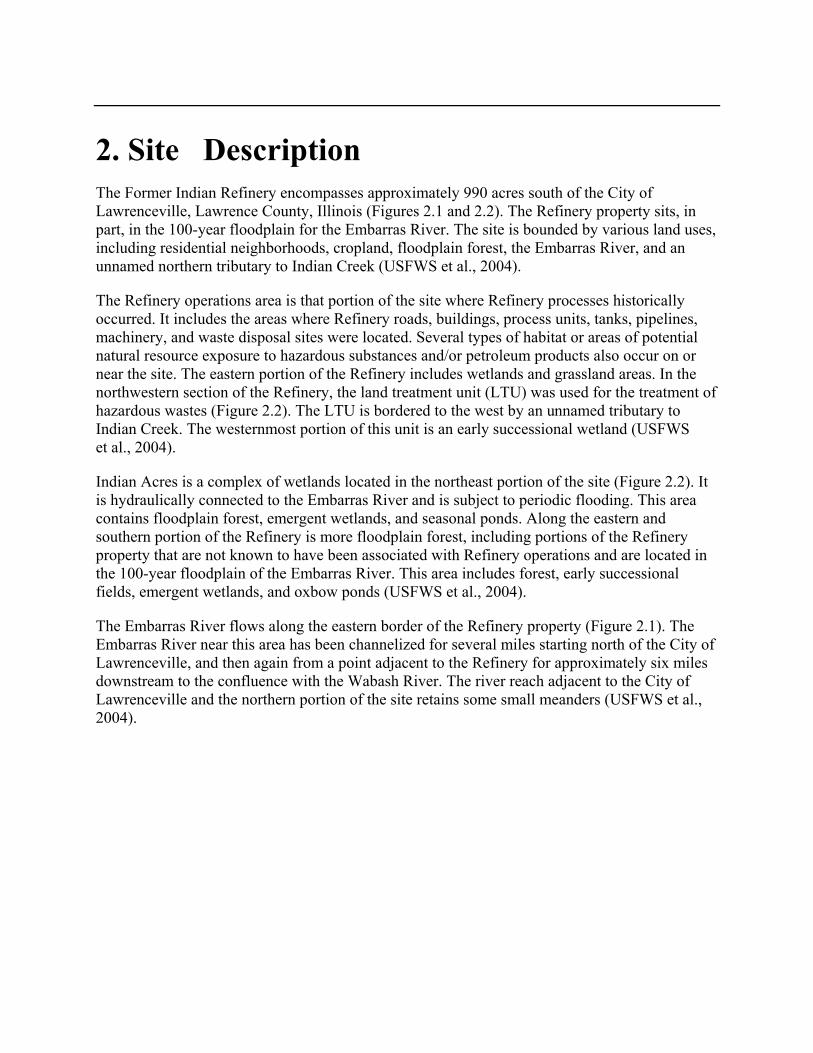
2. Site Description The Former Indian Refinery encompasses approximately 990 acres south of the City of Lawrenceville, Lawrence County, Illinois (Figures 2.1 and 2.2). The Refinery property sits, in part, in the 100-year floodplain for the Embarras River. The site is bounded by various land uses, including residential neighborhoods, cropland, floodplain forest, the Embarras River, and an unnamed northern tributary to Indian Creek (USFWS et al., 2004).
The Refinery operations area is that portion of the site where Refinery processes historically occurred. It includes the areas where Refinery roads, buildings, process units, tanks, pipelines, machinery, and waste disposal sites were located. Several types of habitat or areas of potential natural resource exposure to hazardous substances and/or petroleum products also occur on or near the site. The eastern portion of the Refinery includes wetlands and grassland areas. In the northwestern section of the Refinery, the land treatment unit (LTU) was used for the treatment of hazardous wastes (Figure 2.2). The LTU is bordered to the west by an unnamed tributary to Indian Creek. The westernmost portion of this unit is an early successional wetland (USFWS et al., 2004).
Indian Acres is a complex of wetlands located in the northeast portion of the site (Figure 2.2). It is hydraulically connected to the Embarras River and is subject to periodic flooding. This area contains floodplain forest, emergent wetlands, and seasonal ponds. Along the eastern and southern portion of the Refinery is more floodplain forest, including portions of the Refinery property that are not known to have been associated with Refinery operations and are located in the 100-year floodplain of the Embarras River. This area includes forest, early successional fields, emergent wetlands, and oxbow ponds (USFWS et al., 2004).
The Embarras River flows along the eastern border of the Refinery property (Figure 2.1). The Embarras River near this area has been channelized for several miles starting north of the City of Lawrenceville, and then again from a point adjacent to the Refinery for approximately six miles downstream to the confluence with the Wabash River. The river reach adjacent to the City of Lawrenceville and the northern portion of the site retains some small meanders (USFWS et al., 2004).

Stratus Consulting Site Description (12/19/2008)
Page 2-2
Figure 2.1. The City of Lawrenceville, Illinois, and the Former Indian Refinery property.

Stratus Consulting Site Description (12/19/2008)
Page 2-3
2.1 History of the Refinery The Indian Refining Company completed and began operating the Indian Refinery in Lawrenceville in 1907. The Refinery operated from 1907 to 1985, then again from 1990 to 1995. Several important innovations were introduced at the Indian Refinery, including a solvent dewaxing process that led to Havoline Wax-Free motor oil in 1929, and the development of the first furfural solvent extraction in 1933. The Texas Oil Company (Texaco) purchased a controlling interest in the Indian Refining Company in 1931 and purchased the entire company in 1943 (Hinds, 2001).
The northeastern portion of the property known as Indian Acres (Figure 2.2) was dedicated to lube oil refining and production. In the 1950s, lubricant production at the Indian Refinery was discontinued and the manufacturing facility at Indian Acres was dismantled. A small portion of the northern part of Indian Acres was sold to the City of Lawrenceville for the construction of a wastewater treatment plant in the early 1980s (IEPA, 2000; Hinds, 2001).
Figure 2.2. The Former Indian Refinery property in Lawrenceville.

Stratus Consulting Site Description (12/19/2008)
Page 2-4
The Refinery continued production of gasoline and motor oils until the 1980s. It closed in 1985, reopened in 1990, and closed permanently in 1995. Texaco and its predecessors and subsidiaries operated the Refinery until 1985. Indian Refining LP, a subsidiary of Castle Energy, operated the Refinery from 1990 to 1995. American Western Refining obtained the facility in 1995 but did not restart operations and subsequently filed for bankruptcy. The American Western Refining Liquidating Trust (AWRLT) continues minimal on-site operations such as maintenance of water treatment facilities.
During the years of operation, the Refinery produced various products, including liquid petroleum gas, motor gasoline, aviation gasoline, jet fuel, burner oil, diesel oil, home heating oil, fuel oil, asphalt materials, lube oil, and motor oil. Wastes generated by these operations include oily sludges, leaded tank bottoms, acidic lube oil filter clay, lime sludge, catalyst waste, and tar/asphalt wastes (IEPA, 2000).
Remediation history
In 1983 and 1984, EPA conducted a CERCLA Preliminary Assessment and Screening Site Inspection at the Refinery. In 1985, Texaco conducted an investigation of Indian Acres that revealed that the area had been used as a waste disposal area for lube oil acid sludge and lube oil filter cake sludge, both of which are highly acidic wastes that contain high concentrations of petroleum products (U.S. EPA, 2008).
In 1986, the IEPA conducted a preliminary review and visual site inspection at the Refinery pursuant to the Resource Conservation and Recovery Act of 1976 (RCRA), as amended. The review and inspection identified 33 solid waste management units (SWMUs) at the site. The IEPA and Indian Refining entered into a consent order in State court in May 1992, in which Indian Refining agreed to conduct investigations of the 33 SWMUs (U.S. EPA, 2008). Work proceeded under that order until refinery operations halted in 1995.
Site activities in 1996 included (U.S. EPA, 2008):
Placing Indian Acres and the adjacent Baltimore and Ohio (B&O) Pond under a Seal Order to restrict access to these contaminated areas
Removal of contamination at adjacent residential properties that the Refinery had contaminated
Installation of a sewer line through Indian Acres by the City of Lawrenceville, violating the Seal Order and providing a conduit for the migration of contaminants to the Embarras River.

Stratus Consulting Site Description (12/19/2008)
Page 2-5
In June 1997, the USFWS discovered an ongoing oil release and an associated contaminated area on the southern part of the Refinery property near Tank Farm B (at and near Turner Pond, identified in Figure 2.2). EPA conducted a removal action that included collection and treatment of discharged petroleum product from the area, removal and on-site treatment of petroleum-soaked soils, and installation of an interceptor trench to prevent further migration of the petroleum plume (U.S. EPA, 2008).
AWRLT maintains on-site oil-water separators and a wastewater treatment facility, where effluent from separators is treated and subsequently discharged into the Embarras River pursuant to a National Pollutant Discharge Elimination System (NPDES) permit. Water and petroleum from the Tank Farm B interceptor trench is directed to the separator and treatment plant. Other than water treatment facilities and some administrative and storage buildings, aboveground structures were demolished between 1998 and 2003 (U.S. EPA, 2008).
In June and July 2005, the City of Lawrenceville removed and sealed the Indian Acres sewer line. A new sewer line was routed around areas of known contamination (SECOR International and Trihydro Corporation, 2005).
Texaco has submitted plans to remove the underground pipes at the site, work that is expected to occur in 2008. The RI has been completed and is in review. IEPA, Texaco, and Texaco’s contractors are evaluating remedies for the Refinery and expect to release the FS in 2008 (IEPA, 2007). Both the State and the Federal Trustees have had the opportunity to comment on RI documents and work plans, and they will also have the opportunity to provide comment on the FS and the Selected Remedy.
2.2 Sources of Hazardous Substances The primary ongoing sources of hazardous substances at the Refinery are the various refinery wastes or products that were deposited or spilled on site. Areas of waste disposal at the site include Indian Acres, the LTU in the northwestern area of the site, the tank farms, and other areas across the site (see Figure 2.2). In addition, petroleum product, which was most likely released from leaking tanks and pipelines, is present on top of the groundwater under the site.
The waste disposal area at Indian Acres was used for the disposal of lube oil filter clay sludge, acid sludge, and spent filter clay from the former lube oil refinery (Trihydro, 1993). Estimates of the quantity of waste disposed at Indian Acres include 4,500 cubic yards of acid sludge (Trihydro, 1993) and 73,000 cubic yards of lube oil filter clay sludge (Lange, 1986). Crause (1997) reported that leaded tank bottoms (lead-containing liquid and sludge from the bottom of storage tanks) were also disposed of at Indian Acres. No liners or waste containment structures were used in the Indian Acres disposal areas.

Stratus Consulting Site Description (12/19/2008)
Page 2-6
The LTU (also known as the Landfarm), built in the late 1970s, was used for on-site waste processing and disposal. According to CEC (1997), the LTU operated from 1981 until 1988. The following RCRA hazardous wastes or petroleum byproducts were placed in the LTU: slop oil emulsion solids, heat exchanger bundles cleaning sludge, oil/water separator sludge, and leaded tank bottoms. In addition, other tank bottoms (hazardous and nonhazardous), wastewater treatment plant sludges, oily soils and sludges, and raw water softening sludge were also placed in the LTU.
The areas that formerly contained clusters of petroleum storage tanks, known as tank farms, are sources of hazardous substances as well. Tank bottoms and residual sludges were deposited on the land surrounding the tanks. Estimates of deposited waste on the tank farms include 70 cubic yards of leaded tank bottoms and 1,400 cubic yards of crude sludge placed in Tank Farm B South, 4 cubic yards of leaded tank bottoms placed in Tank Farm B North, and 170 cubic yards of leaded tank bottoms and 2,800 cubic yards of crude sludge placed in Tank Farm E (Figure 2.2; Lange, 1986).
In 1997, the USFWS discovered that petroleum products and contaminated groundwater from Tank Farm B was being released into the adjacent floodplain forest wetlands. As part of the response action, a total of 10,287 cubic yards of contaminated soils were excavated from the impacted area and placed in on-site bioremediation cells located within tank berms in Tank Farm B. Approximately 11 million gallons of contaminated water was pumped to the oil/water separator during the 16 months of removal activities (USFWS, 1997). The free-phase petroleum product released to the wetlands contained benzene, toluene, xylene, methylnaphthalene, naphthalene, 1,3,5-trimethylbenzene, and other petroleum hydrocarbons (U.S. EPA, 2008).
Soil data from the Phase I remedial investigation (Trihydro, 2006) show the presence of heavy metals; benzene, toluene, ethylbenzene, and xylenes (BTEX); polycyclic aromatic hydrocarbons (PAHs); and other organic contaminants in soils throughout the site. Hazardous substances and petroleum products released at the Refinery include, but are not limited to, those substances and compounds shown in Table 2.1.
As part of the cooperative assessment, the State and Federal Trustees and Texaco prepared “SPE” documents that review contaminant sources and pathways and natural resources exposure in many areas in and near the Refinery. Specifically, these SPE documents present a compilation and review of available information on the sources of hazardous substances and/or petroleum products, pathways by which the hazardous substances and/or petroleum products reached Trustee natural resources, and the evidence that those natural resources were exposed. Additional information about sources is included in Chapter 5, where information from the SPE documents is summarized.

Stratus Consulting Site Description (12/19/2008)
Page 2-7
Table 2.1. Hazardous substances and/or petroleum products released at the Former Indian Refinery
Class of substances Hazardous substance and/or
petroleum product Metals Arsenic and compounds Chromium and compounds Copper and compounds Lead and compounds Man ganese and compounds Mercury and compounds Zinc and compounds
Benzene Ethylbenzene Toluene
Aromatic hydrocarbons
Xylenes Acenaphthene
Anthracene Benzo(a)pyrene Benzo(a)anthracene 1-Methylnaphthalene
Polycyclic aromatic hydrocarbons
2-Methylnaphthalene 2-Butanone Acetone Bis(2-ethylhexyl)phthalate Cyclohexane Methylene chloride
Other organic contaminants
Trichlorofluoromethane Source: Trihydro, 2006.

3. Pathways The NRDA included an assessment of whether sufficient exposure pathways exist (or have existed) by which hazardous substances are (or were) transported in the environment, resulting in natural resource exposure to those substances [43 CFR § 11.63]. This section presents a summary of pathway information; pathways were carefully examined in SPE documents for the site (e.g., Appendices E and F). Pathways were determined using a combination of information about the nature and transport mechanisms of the hazardous substances, potential pathways, and data documenting the presence of the hazardous substances in the pathway resource.
Figure 3.1 presents a general diagram of pathways by which both State and Federal Trustee natural resources were exposed to hazardous substances and/or petroleum products that the Refinery released. Some Trustee natural resources are in direct contact with sources. Hazardous substances and/or petroleum products also have been and continue to be transported to Trustee natural resources via the following pathways.
Geologic (soil) pathway [43 CFR § 11.63(e)] Groundwater pathway [43 CFR § 11.63(c)] Surface water pathway [43 CFR § 11.63(b)].
Releases of hazardous substances and/or petroleum products from the Refinery have directly exposed soil, sediment, groundwater, and surface water to contamination. This contamination is transported in the environment, resulting in further exposure of natural resources to contaminants from the site (Figure 3.1).
Soils have been exposed directly to hazardous substances and/or petroleum products by spills, leaks, and contaminant disposal into landfills. The contaminated soil has itself exposed other natural resources to contamination. For example, in floodplain forests, surface water has been exposed by overland flow and drainage from areas of contaminated land and soils. The erosion of contaminated surface soils and creek banks has likely exposed sediments in aquatic areas of the site.
Surface water and sediments have been exposed to contamination by historic discharges, disposal activities, leaks, and spills. Surface water runoff and floodwaters over contaminated land may entrain contaminants from floodplain waste disposal sites. In addition, contaminated groundwater may discharge into surface water resources, such as occurred in 1997 when petroleum products and contaminated groundwater discharged into the wetland near Tank Farm B.

Stratus Consulting Pathways (12/19/2008)
Page 3-2
Piscivorous birds
Waterfowl Fish Reptiles/amphibians Mammals Passerine birds
Source releases
Terrestrialplants
Benthicinvertebrates
Aquaticvegetation
Riparianvegetation
Terrestrialinvertebrates
Groundwater SoilSediment Surface water
Raptors
Figure 3.1. Simplified pathways by which hazardous substances are transported to Trustee natural resources.

Stratus Consulting Pathways (12/19/2008)
Page 3-3
Groundwater resources at the Refinery have been exposed to hazardous substances and/or petroleum products by infiltration of liquid petroleum wastes through unsaturated soils after spills from tanks, disposal areas, and leaking underground pipes. In addition, groundwater resources are exposed when infiltrating precipitation transports surface contaminants from soils through the unsaturated zone and into shallow groundwater.
Chapter 5 presents data showing that hazardous substances and/or petroleum products in soils, surface water, and groundwater are present at the Refinery in sufficient concentrations to serve as a pathway to other natural resources.

4. NRDA Approach This chapter describes the approach that the State and Federal Trustees and Texaco used to determine and quantify natural resource damages at the Refinery. The assessment was conducted in accordance with the Assessment Plan that was released to the public on October 5, 2006 [71 FR 58873].
In NRDA, natural resource “injuries” are determined by comparing resources to “baseline” conditions. A natural resource injury is “a measurable adverse change, either long- or short-term, in the chemical or physical quality or the viability of a natural resource resulting either directly or indirectly from exposure to a discharge of oil or release of a hazardous substance” [43 CFR § 11.14(v)]. Baseline conditions are the “conditions that would have existed at the assessment area had the discharge of oil or release of the hazardous substance under investigation not occurred” [43 CFR § 11.14(e)]. Natural resource injuries are determined and quantified prior to the assessment of compensable damages.
This chapter provides an overview of the approach and methods that were used in the assessment. Additional details are provided in Chapters 5 and 6, which present the results of the injury assessment and damages assessment, respectively.
4.1 Refinery NRDA Overview The State and Federal Trustees and Texaco conducted the NRDA for the Refinery cooperatively. DOI regulations allow for NRDAs to be conducted cooperatively between Trustees and a PRP [43 CFR § 11.32 (d)]. A cooperative NRDA is intended to provide the public with the appropriate amount of resource restoration sooner and at less cost than if Trustees were to conduct the NRDA unilaterally. The cooperative approach allowed this NRDA to proceed concurrently with the RI/FS, with the State and Federal Trustees and Texaco freely sharing information, data, and expertise, avoiding duplication, reducing costs, and achieving common objectives where possible. In conducting the NRDA cooperatively with Texaco, the State Trustees were able to reach agreement more expeditiously on the natural resource restoration that is required to make the public whole for the natural resource injuries.
This NRDA relies primarily on the extensive site-specific information and data that were collected as part of the RI at the Refinery. IEPA has been overseeing the RI/FS since September 2000, when EPA requested that IEPA take lead oversight responsibility for the site. A consent decree in October 2001 called for the RI to be completed in three phases, with the main processing areas evaluated in later phases to allow for complete removal of refinery
Stratus Consulting NRDA Approach (12/19/2008)
Page 4-2
infrastructure (SECOR International et al., 2004b). By the summer of 2007, all phases of the RI were complete, including draft ecological and human health risk assessments (IEPA, 2007).
The data and information collected in the three phases of the RI include chemical contamination data for thousands of environmental samples, information on historical operations and waste disposal practices at the Refinery, surface water and groundwater pathways of contaminant migration, and ecological resources at and near the Refinery. In addition to the data and information from the RI, the State and Federal Trustees and Texaco also conducted focused studies specifically for the NRDA, such as the compilation and review of historical wastewater discharge permits, notices of violations of those permits, and the chemical analysis of selected petroleum source areas to help identify natural resource exposure to substances released from the Refinery.
Based on initial reviews of data and information for the Refinery, the State and Federal Trustees and Texaco grouped the areas and resources of the Refinery into the following four categories, assessing injuries and damages separately for each category:
Habitat areas along the eastern side of the Refinery, between the Refinery and the Embarras River, and south of the Refinery (Figure 4.1). These areas are floodplain forest habitat in the Embarras River floodplain.
Surface water resources, which include the Embarras River adjacent to the Refinery and several other water bodies at or adjacent to the Refinery (Figure 4.2).
Groundwater resources.
Individual organisms injured by exposure to contaminants within the industrial footprint of Refinery operations (Figure 4.1).
These four resource categories encompass all of the types of natural resources that were addressed in the injury assessment. In terms of the DOI regulations for conducting an NRDA, these resource categories include the following specific natural resources [43 CFR § 11.14(z)]: biological resources, geologic resources, surface water resources, and groundwater resources.

Stratus Consulting NRDA Approach (12/19/2008)
Page 4-3
Figure 4.1. Floodplain forest habitat identified as potentially injured and areas within the industrial footprint of the Refinery. Different approaches were used to assess injuries and damages in these areas.

Stratus Consulting NRDA Approach (12/19/2008)
Page 4-4
Figure 4.2. Surface water resources (in blue) investigated for potential injury.

Stratus Consulting NRDA Approach (12/19/2008)
Page 4-5
4.2 Conducting the NRDA Prior to Remedy Selection
The State and Federal Trustees and Texaco conducted this cooperative NRDA concurrently with the RI/FS. Currently, the FS is ongoing and a remedy to address substantial threats to health, welfare, and the environment from contamination at the site has not yet been selected.1 Therefore, the extent of contaminant cleanup that will be conducted at the Refinery as part of response actions cannot be specified. This represents an uncertainty in how and when injured natural resources at the Refinery will be returned to baseline conditions, and in the amount of residual injuries that will remain following implementation of the selected remedy.
The State and Federal Trustees and Texaco addressed this response action uncertainty at the Refinery by using “reasonable worst-case” assumptions about what the selected remedy will be and what the residual injuries will be following remedy implementation. In order to determine reasonable worst-case assumptions, the State and Federal Trustees and Texaco consulted with the site Remedial Project Manager from IEPA and with Texaco RI/FS contractors to identify a range of cleanup alternatives. For each potential remedial alternative, estimates of the natural resource injuries that will remain following remedy implementation were developed, including the timeframe and degree of residual injury at each sub-unit, and the short-term and long-term injuries that are caused by the remedies themselves.
To ensure that the NRDA settlement fully compensates for the natural resource injuries at the Refinery, future injuries were quantified based on the “worst-case” remedial alternatives that result in the greatest amount of future injury. For most of the sub-units, the monitored natural attenuation remedy, in which no cleanup actions are conducted, results in the largest amount of future injury. At some sub-units, the largest amount of future injury results from remedies that cause significant habitat alterations, such as remedies that involve removal of contamination with heavy machinery (which can increase short-term injuries to ecological habitat), or remedies that require waste disposal areas to be capped in place and maintained indefinitely. Although some of the cleanup alternatives considered are unlikely to be selected at the conclusion of the RI/FS, they were nevertheless included in the analysis to ensure that future injuries to natural resources were not underestimated.
1. Neither CWA nor OPA provides any restrictions upon when a lawsuit to recover natural resource damages may be commenced. While Section 9613 (g)(1) of CERCLA provides that a lawsuit to recover natural resource damages may not be commenced “before selection of the remedial action if the President is diligently proceeding with a remedial investigation and feasibility study under section 9604(b),” that provision does not preclude prosecution of NRDA claims where the RI/FS is proceeding under State oversight, nor does it preclude entry of NRDA settlements prior to remedy selection or completion of the RI/FS by a Federal agency acting on behalf of the President.

Stratus Consulting NRDA Approach (12/19/2008)
Page 4-6
In summary, the State and Federal Trustees and Texaco addressed the uncertainty of the future remedy by assuming that the worst-case remedy would be selected at all sites and by quantifying future injuries based on that worst-case remedy. These assumptions assure that future residual injuries are not underestimated, regardless of which remedy is selected for the site. In fact, it is likely that the State and Federal Trustees and Texaco overestimated the injuries at the Refinery, because the worst-case remedy is unlikely to be selected in many sub-units. However, even if an unprotective remedy is selected at a sub-unit, the injury quantification in this NRDA accounts for the future residual injuries that would result. By using this approach to address the uncertainty of an unselected remedy, the State Trustees and Texaco reached a proposed NRDA settlement prior to selection of the remedy for the site.
4.3 Injury Assessment Approach The injury assessment for the Refinery consisted of determining and quantifying the injuries to natural resources that resulted from releases of hazardous substances and/or petroleum products from the Refinery. Injury determination is the identification of what injuries result from the releases, and injury quantification is the quantification of the nature, degree, and extent of the injuries. Injuries are quantified against baseline conditions. The term “injury assessment” in this document refers to the combination of injury determination and quantification that was conducted for the Refinery.
Injuries were determined using the injury definitions in the DOI NRDA regulations at 43 CFR § 11.62. Some injury definitions include specific numeric injury thresholds, such as Federal or State drinking water standards for groundwater or aquatic life standards or criteria for surface water. Other definitions are narrative, such as concentrations of hazardous substances that are sufficient to cause adverse changes in the viability of biological resources, or to cause injury to another resource that comes in contact with a resource. The specific injury definitions used in the injury determination for each resource are detailed in the Assessment Plan.
Uncertainties regarding baseline conditions and the extent of natural resource injuries were addressed using the “reasonable worst-case” assumptions described previously for addressing uncertainty in the selected remedy. In cases where data variability was high, sample coverage was low, or baseline conditions were uncertain, the State and Federal Trustees and Texaco assumed the highest reasonable degree of injury. This stipulation was more timely and cost-effective than collecting additional data, even if it resulted in an overestimate of injuries and damages.

Stratus Consulting NRDA Approach (12/19/2008)
Page 4-7
4.3.1 Injuries to floodplain forest habitat
Floodplain forest habitat is the predominant habitat type in many areas at the Refinery and in areas south and east of the Refinery that were used as waste disposal areas or where contaminants have migrated (Figure 4.1). Floodplain forests occupy low-lying areas adjacent to streams and rivers and are subject to periodic flooding. Mature floodplain forests typically contain different woody species, including a tree canopy with a mixture of shade-tolerant and shade-intolerant species; shrubs, vines, and herbaceous species; and standing dead trees and fallen logs (Basinger and Edgin, 2006). Dominant vegetation in the floodplain forest includes silver maple (Acer saccharinum), green ash (Fraxinus pennsylvanica), eastern cottonwood (Populus deltoides), box elder (Acer interius), common reed (Phragmites australis), and narrow-leaved cattail (Typha angustifolia). The leatherflower (Clematis viorna), a State endangered species, has been identified in the floodplain forest between the Refinery and the Embarras River (SECOR International et al., 2004b).
A total of 181 bird species have been identified in the area of the Refinery, particularly in floodplain forest habitat. Seven species of frogs and toads, two salamander species, eight snake species, six turtle species, and two skinks have been observed in the floodplain forest and the grasslands at the Refinery (SECOR International et al., 2004b). The Indiana bat, listed on both the State and Federal endangered species lists, is known to occur in Lawrence County, and the Refinery property contains suitable habitat (Gardner et al., 1996).
An assessment of injuries to individual resources within the floodplain forest, such as the leatherflower or the Indiana bat, may have resulted in an incomplete evaluation of injuries to all Trustee resources. Therefore, injuries to Trustee natural resources in the floodplain forest were assessed using Habitat Equivalency Analysis (HEA), where injuries to all Trustee natural resources were quantified as the loss of habitat ecological services caused by the releases of contaminants into the floodplain forest habitat. The DOI regulations define natural resources services as “the physical and biological functions performed by the resource including the human uses of those functions. These services are the result of the physical, chemical, or biological quality of the resource” [43 CFR § 11.14(nn)]. Example resource services include physical habitat for wildlife, nutrient and energy cycling, food web interactions, flood control, groundwater recharge, and recreation [43 CFR § 11.71(e)]. HEA is used to determine the amount of restoration that is required to compensate for past, current, and future (i.e., residual to any cleanup) reductions in habitat services.
A benefit of HEA is that it explicitly creates a connection between services lost because of injury and services gained through restoration. The connection provides a clear demonstration to the public that Trustees have fulfilled their mandate of compensating the public for losses of natural resources and their services. The implicit assumption of HEA is that the public can be compensated with direct service-to-service restoration scaling, where the services provided by

Stratus Consulting NRDA Approach (12/19/2008)
Page 4-8
proposed habitat restoration actions are of similar type, quality, and value as the services lost because of injury to the overall habitat of an impacted area (Allen et al., 2005; NOAA, 2006).
The Assessment Plan (Appendix B) and Chapter 5 describe the HEA method in more detail. The HEA model, developed by the U.S. National Oceanic and Atmospheric Administration (NOAA), has been applied in many NRDAs as a tool for quantifying injuries and scaling restoration. One of the key inputs required for HEA is the degree of ecological service losses caused by releases of hazardous substances and/or petroleum products, typically expressed as the percent of services lost compared to the services that would have been provided by the habitat absent contamination (i.e., under baseline conditions).
To estimate the degree of ecological service loss in floodplain forest habitat that results from contaminant releases from the Refinery, the State and Federal Trustees and Texaco developed a quantitative model that relates site contaminant concentrations measured in soil, sediment, and surface water to ecological services losses. First, contaminant dose-response models were developed from the toxicological literature to predict the degree of toxicity to biota caused by different concentrations of contaminants in soil, sediment, or surface water. The predicted toxicological response was then used to estimate habitat service loss. Based on this relationship, the extensive database of contaminant concentrations in soil, sediment, and surface water at the Refinery was utilized to develop initial estimates of service loss. Other information, such as aerial photographs showing presence/absence of vegetation, the presence of unvegetated tarry waste at the surface, site operational history, and contaminant transport pathways, was used in addition to the chemistry data to develop the final estimates of service losses in floodplain forest habitat for input to the HEA model. The details of the methods used to estimate floodplain forest habitat service losses are presented in Chapter 5.
4.3.2 Injuries to surface water, groundwater, and organisms exposed in the Refinery footprint
Available data and information were compiled and analyzed to develop estimates of the spatial extent, temporal extent, and degree of the injuries to groundwater, surface water, aquatic habitat, and individual organisms exposed to contaminants within the Refinery footprint. The spatial extent, temporal extent, and degree of injuries were then considered qualitatively in the scaling of restoration to compensate for these injuries. HEA was not an appropriate scaling tool for these particular injuries. For aquatic habitat, most of the injuries occurred in the past when the Refinery was still operating. Data were insufficient to allow for quantification of injuries as aquatic habitat service losses in a HEA. The State and Federal Trustees and Texaco agreed that worst-case estimates of injuries to these resources potentially resulting in an overestimate of damages were more cost-effective than attempting to collect sufficient data to allow for the use of HEA.

Stratus Consulting NRDA Approach (12/19/2008)
Page 4-9
Groundwater and the Refinery industrial footprint are not habitat, per se, and thus HEA is not an appropriate tool to use to quantify injuries. Specific details of the injury assessment conducted for groundwater and organisms injured within the Refinery footprint are included in Chapter 5.
4.4 Damages Assessment Approach
The State and Federal Trustees and Texaco used a restoration-based approach to quantify damages. Damages for the site were quantified as the type and amount of resource restoration required to offset the natural resource injuries caused by the Refinery, where “restoration” as used in this document refers to directly restoring the injured resource, or to rehabilitating, replacing, or acquiring equivalent resources [43 CFR § 11.80(b)]. The State and Federal Trustees and Texaco identified and screened potential restoration projects, and the State and Federal Trustees selected preferred projects. These projects were then scaled to determine the amount of restoration required to offset the injuries and thereby make the public whole. As described in Chapter 6, the NRDA settlement includes restoration actions in the form of acquisition and transfer of property that Texaco will implement directly, as well as restoration actions that Texaco will fund and the State Trustees will implement. The selected restoration projects will benefit natural resources near the Refinery and will provide improvements to the equivalent resources or resource services that were injured and lost. Therefore, the restoration will directly compensate for the injuries caused by hazardous substance and/or petroleum product releases at the Refinery.

5. Natural Resource Injuries This chapter presents the results of the cooperative injury assessment in this NRDA. Chapter 6 then presents the proposed restoration to offset these injuries to Trustee natural resources.
Section 5.1 presents injuries to floodplain forest habitat areas in and adjacent to the Refinery property. Section 5.2 describes injuries to aquatic habitat, Section 5.3 describes injuries to natural resources within the Refinery footprint, and Section 5.4 describes injury to groundwater. Section 5.5 then summarizes the injury data.
5.1 Floodplain Forest Habitat Most of the injured habitat in and adjacent to the Refinery property is Embarras River floodplain forest. The State and Federal Trustees and Texaco evaluated several different floodplain forest habitat areas separately. Figure 5.1 shows each of the evaluated floodplain forest areas.
The State and Federal Trustees and Texaco developed basic guidelines and a toxicity model for estimating service loss. The general guidelines for service loss include the following:
If hazardous substance and/or petroleum product concentrations do not, have not, and are not expected to exceed baseline concentrations and injury thresholds, there is no service loss.
If petroleum product or tar covers the ground surface and little or no vegetation is growing, service loss is 100%.
If hazardous substance and/or petroleum product concentrations exceed baseline concentrations and injury thresholds, the basic toxicological dose-response relationship applies when assigning service loss: the higher the concentrations of hazardous substances and/or petroleum products, the higher the service loss.
The State and Federal Trustees and Texaco developed a model to estimate service loss based on concentrations of hazardous substances and/or petroleum products in soils, sediments, and surface water. The model output was supplemented with relevant site-specific information such as aerial photographs, the presence of unvegetated tarry waste at the surface, and site operational history to designate the percent service loss for each floodplain forest area over time. These service loss estimates were then input to HEA models to estimate the total injury over space and time for each area.

Stratus Consulting Natural Resource Injuries (12/19/2008)
Page 5-2
Figure 5.1. Floodplain forest habitat areas (shown in green) for which injuries were assessed in the floodplain forest HEA.

Stratus Consulting Natural Resource Injuries (12/19/2008)
Page 5-3
Quantitative service loss model
As an aid in estimating service loss for settlement purposes, the State and Federal Trustees and Texaco developed a quantitative model that they called the “Tool.” The Tool relates measured chemical concentrations in soil, sediment, and surface water to floodplain forest service losses, incorporating a series of quantitative toxicological dose-response models that estimate toxicity and service loss from the available database of contaminant concentrations. First, the Tool calculates the estimated toxicity and service loss in each sample caused by each individual contaminant. The separate service losses from each contaminant are then combined into a single service loss estimate for the sample as a whole.
The results of the Tool service loss calculations were displayed on aerial photographs of each habitat area using a geographic information system (GIS). The State and Federal Trustees and Texaco used these plots to guide their estimates of service loss across each area.
The Tool incorporates the following dose-response toxicological models:
A model relating the molar sum of 18 PAHs in soils to estimated service loss, based on a literature review of the toxic effects of PAHs to soil invertebrates (Appendix D)
A model relating organic contaminants (except PAHs) and metals in soils to estimated service loss, based on threshold concentrations from the Refinery’s screening-level ecological risk assessment (SLERA) (ELM Consulting, 2004) and the dose-response curve from the soil PAH model
A model relating the concentrations of hazardous substances in surface water to estimated service loss, based on the guidance for developing aquatic life criteria under the CWA (e.g., Stephan et al., 1985) and data from the SLERA (ELM Consulting, 2004)
A model relating the concentrations of hazardous substances in sediment to estimated service loss, based on threshold concentrations in MacDonald et al. (2000) and dose-response curves in Field et al. (2002).
Appendix D is a memorandum describing the development of the soil PAH service loss model in detail. As described in the appendix, a comprehensive dose-response model was developed from data on the toxicity of PAHs to soil invertebrates as reported in the literature. The toxicological evaluation of soil PAHs focused on invertebrates because these organisms are typically sensitive to the toxic effects of PAHs. The dose-response model predicts the degree of toxicity of soil PAHs to soil invertebrates based on a combination of mortality, reproduction, and growth endpoints.

Stratus Consulting Natural Resource Injuries (12/19/2008)
Page 5-4
Figure 5.2 shows the relationship between soil PAH concentrations and ecological service loss from the model in Appendix D. The fitted curve results in an equation for estimating service loss based on the molar sum of PAHs in soil. Service losses are incurred at concentrations over 0.26 µmol/g PAH in soil, with 100% service loss if concentrations exceed 1.7 µmol/g. Appendix D provides the details of the literature review and incremental steps that resulted in Figure 5.2.
For injuries caused by soil contaminants other than PAHs (i.e., other organic chemicals and metals), injury thresholds were taken from the SLERA (ELM Consulting, 2004). The thresholds in the SLERA are typically no-effect level threshold concentrations, meaning that there is a high probability that there are no effects at concentrations less than the thresholds. Service losses at concentrations above the injury thresholds were estimated using the same shape (but not the same injury threshold) of the dose-response curve that was developed for PAHs. In other words, since 100% service loss from PAHs occurs at a concentration (1.7 µmol/g) that is 6.5 times the injury threshold concentration (0.26 µmol/g), it was estimated that 100% injury also occurs for all other soil contaminants at 6.5 times their respective injury thresholds. This same approach was used for estimating service losses for organic contaminants in sediment using injury thresholds from the SLERA (ELM Consulting, 2004).
y = 53.888Ln(x) + 72.42R2 = 0.9732
0
25
50
75
100
0 0.5 1 1.5 2
Total PAH concentration (mol/g soil)
Serv
ice
loss
(%)'
Figure 5.2. Modeled relationship between service loss (as a percent loss compared to baseline conditions) and PAH concentrations in soil.

Stratus Consulting Natural Resource Injuries (12/19/2008)
Page 5-5
For metal contamination measured in sediments within the floodplain forest habitat, service losses were estimated using a dose-response model that is based on injury thresholds from MacDonald et al. (2000) and dose-response curves from Field et al. (2002). Most of the selected injury thresholds for sediment metals were threshold effects concentrations, or concentrations below which adverse effects to aquatic invertebrates are not expected. The Field et al. (2002) dose-response curves for nine separate metals showed that, on average, the concentration toxic to 50% of exposed organisms was about three times the concentration toxic to 20% of exposed organisms. Similarly, the concentration toxic to 80% of exposed organisms was about 10 times the concentration toxic to 20% of exposed organisms (Field et al., 2002).
The Field et al. (2002) ratios were used to estimate service loss based on contaminant concentrations in sediment (Table 5.1). The injury threshold concentration from MacDonald et al. (2000) was assumed to be the concentration toxic to 20% of the organisms. Three times the injury threshold concentration, toxic to 50% of the exposed organisms (Field et al., 2002), was assigned a 50% service loss. Ten times the injury threshold concentration, toxic to 80% of the organisms (Field et al., 2002), was assigned a 90% service loss. The curve was then extrapolated to estimate 100% service loss when contaminant concentrations were at least 15 times the injury threshold concentration.
Table 5.1. Dose-response relationship for metals in sediment Ratio of measured concentration to threshold injury concentration
Predicted toxicity expressed as percent of exposed organisms that will experience toxicity
Estimated service loss
1 < 20% 0% 3 50% 50%
10 80% 90% 15a 10 0% 100%
a. The estimate of 100% mortality at 15 times the injury threshold was derived by extrapolation from the other data.
Service loss estimates based on contaminant concentrations in surface water were made using Federal or State water quality criteria as injury thresholds, and the relationship of the assigned threshold to toxicity (e.g., Stephan et al., 1985). For most contaminants, the chronic criterion was used as the injury threshold, and service loss was estimated to be 50% at a concentration equal to an acute criterion. A 100% service loss was estimated to occur at concentrations more than four times the acute criterion.
Finally, for each soil, sediment, or surface water sample, the Tool combined the calculated service loss for each individual contaminant into a single service loss estimate for the sample as a whole using a response addition model (Field et al., 2002; Borgert et al., 2004). The net service

Stratus Consulting Natural Resource Injuries (12/19/2008)
Page 5-6
loss was based on residual services. For example, a concentration of a given contaminant resulting in a calculated 25% service loss leaves 75% residual services. The total net service loss was one minus the product of the residual services for all contaminants. Therefore, if three contaminants in a sample each caused a 25% service loss, the total service loss for the sample was (1 – [75% 75% 75%]) = 58% net service loss.
HEA models
The injury assessment provides the degree and spatial and temporal extent of resource service losses, and the HEA models provide a method for scaling the equivalent restoration to offset the injuries. Restoration is scaled so that the natural resource service gains provided through restoration equal the cumulative service losses at the injured site (Allen et al., 2005; Cacela et al., 2005; NOAA, 2006).
The information required to quantify the habitat service loss (or HEA “debits”) includes (1) time periods of injury, including evaluation of the effect of response activities and scenarios for future losses if necessary; (2) spatial extent of injury; (3) quantification of lost services over space and time compared to baseline conditions; (4) a discount rate; and (5) a base year. Debits are commonly expressed in units of discounted service acre-years (DSAYs).
The State and Federal Trustees and Texaco used a 3% discount rate and 2006 as the base year for all HEA injury calculations. Injuries were calculated starting in 1981, just after the Federal Superfund law was passed in December 1980. Estimated future injuries were calculated through 2110, at which time any ongoing injuries have negligible impact on the total injury because future injuries are discounted relative to the present.
The spatial extent of injury and quantification of lost services were estimated using site contaminant data, the Tool, and other available site-specific information. HEA debits to floodplain forest habitat are expressed in units of DSAYs.
5.1.1 Indian Acres
Indian Acres is in the northeast corner of the Refinery property (Figure 5.1). The primary sources of hazardous substances and/or petroleum products in Indian Acres are lube oil filter clay and acidic sludge from a lube oil fabrication process that occurred on the western side of Indian Acres from 1915 through 1950. The unvegetated, acidic, tarry waste is evident in the floodplain forest (Figures 5.3 and 5.4). Some tarry wastes were buried and now have vegetation growing on the surface; the State and Federal Trustees and Texaco assumed that any evidence of petroleum waste in the upper three feet of soil represented a potential injury to Trustee resources. The SPE (Appendix E) included an analysis of boring logs from Indian Acres documenting the presence or absence of petroleum waste.

Stratus Consulting Natural Resource Injuries (12/19/2008)
Page 5-7
The State and Federal Trustees and Texaco divided Indian Acres into different sub-areas based on the industrial history and the presence and concentrations of hazardous substances and/or petroleum products. On the eastern side of Indian Acres, baseline habitat is floodplain forest providing 100% of floodplain forest services. In addition, baseline habitat for unvegetated tarry waste disposal sites anywhere in Indian Acres was assumed to be floodplain forest providing 100% of floodplain forest services.
Figure 5.3. 1999 aerial view of the main lube oil filter clay and acid sludge disposal area at Indian Acres. Photo source: Greg Ratliff, IEPA.

Stratus Consulting Natural Resource Injuries (12/19/2008)
Page 5-8
The western side of Indian Acres was part of the Refinery infrastructure until the 1950s. Roads, refinery buildings, and other infrastructure disturbed the habitat. Therefore, in these areas, baseline conditions are not a fully functioning floodplain forest. The State and Federal Trustees and Texaco estimated that these areas provide 50% of the baseline services of fully functioning floodplain forest. Injuries from contamination at these areas were quantified assuming this 50% baseline condition.
Figure 5.4. Main lube oil filter clay and acid sludge disposal area at Indian Acres. July 2000. Photo source: Greg Ratliff, IEPA.

Stratus Consulting Natural Resource Injuries (12/19/2008)
Page 5-9
Figure 5.5 shows areas that contain unvegetated tarry waste at the surface, petroleum waste in the upper three feet of soils, and petroleum waste below three feet. These data were compiled from site investigations and RI/FS reports (CEC, 1997; SECOR International et al., 2004a; Trihydro, 2006). Figure 5.6 then presents the results from the Tool data analysis as well as the final estimated service losses in Indian Acres based on Tool results and other information. Table 5.2 summarizes the total service loss and DSAYs of debit at Indian Acres.
Table 5.2. Service loss and HEA debit in Indian Acres sub-areas, 1981-2110
Description Baseline services
Service loss
Area (acres)
Debit (DSAYs)
Former lube oil refinery; high contaminant concentrations and petroleum waste in soils 50% 100% 12.4 382 Former lube oil refinery; moderate contaminant concentrations and petroleum waste in soils 50% 75% 14.1 248 Unvegetated tarry waste; oily waste apparent at ground surface; high contaminant concentrations 100% 100% 12.8 848 Floodplain forest surrounding waste disposal areas; moderate contaminant concentrations 100% 62.5% 10.8 552 Floodplain forest east of disposal areas; low to moderate contaminant concentrations 100% 25% 11.0 290 Total 61.1 2,321
The State and Federal Trustees and Texaco evaluated between three and nine different potential remedies at each Indian Acres sub-area, and they estimated future service loss for each scenario. Scenarios ranged from complete removal of contamination with constructed wetlands to monitored natural attenuation with no cleanup. The worst-case remedy that resulted in the largest amount of potential future injuries for most areas was monitored natural attenuation. For areas of devegetated tarry waste, natural attenuation was not considered to be a reasonable scenario. The State Trustees (including IEPA), the Federal Trustee, and Texaco agreed that the extent of the contamination in the tarry waste areas clearly requires a response action. Thus, the worst-case scenario for these tarry waste areas was a permanent engineered cap over the contamination with poor vegetation and few habitat services.
5.1.2 SWMU 28/30
SWMU 28 and SWMU 30 are on the eastern side of the Refinery, immediately south of the Firewater Ponds (Figure 5.1). For this assessment, the two SWMUs are considered to be one unit. Absent contamination, baseline habitat is floodplain forest providing 100% of floodplain forest services.

Stratus Consulting Natural Resource Injuries (12/19/2008)
Page 5-10
Figure 5.5. Areas with unvegetated tarry waste at the surface, tarry waste within the upper three feet of soils, and tarry waste below three feet. The State and Federal Trustees and Texaco incorporated this information into the injury quantification for Indian Acres. Data sources: CEC, 1997; SECOR International et al., 2004a; Trihydro, 2006.

Stratus Consulting Natural Resource Injuries (12/19/2008)
Page 5-11
Figure 5.6. Estimated service loss at Indian Acres. Baseline conditions for tarry waste areas and areas on the eastern side of Indian Acres were assumed to be 100% of floodplain forest services. Baseline conditions in areas on the western side were assumed to provide 50% of floodplain forest services.

Stratus Consulting Natural Resource Injuries (12/19/2008)
Page 5-12
The SWMU 28/30 area was used as a landfill for petroleum waste during Refinery operations. The unit received spent catalyst from the fluid catalytic cracking unit (FCCU), as well as boilerhouse sludge, asbestos insulation, construction waste, and asphaltic material. Impurities removed from the FCCU catalyst and deposited in SWMU 28/30 include aluminum oxide, silicon dioxide (sand), and iron. Lead may also be present in older FCCU waste, because oils containing leaded gasoline were recirculated through the FCCU (Trihydro, 1993).
Some areas in SWMU 28/30 contain visible oily waste at the surface. The Tool results show that the majority of soil samples from this area contain hazardous substance concentrations sufficient to cause 100% service loss (Figure 5.7). The State and Federal Trustees and Texaco estimated a 100% loss of natural resource services at this 15.9-acre site. The reasonable worst-case scenario that results in the most future injury was monitored natural attenuation, resulting in 100% service loss in perpetuity. Therefore, the injury quantification is based on the assumption that site remediation will not reduce future injuries. The total HEA debit for this scenario is 925 DSAYs.
5.1.3 SWMU 9 North
SWMU 9 North is on the east side of the Refinery, south and west of the Firewater Ponds, immediately west of SWMU 28/30, and immediately west of the wastewater aeration ponds (Figure 5.1). For this assessment, the State and Federal Trustees and Texaco divided SWMU 9 North into two sub-areas: the northern area and the flare tower area in the south. The northern area of SWMU 9 North includes SWMUs 26 and 29, two small waste disposal units within SWMU 9 North. The southern portion of SWMU 9 North contained a flare tower when the Refinery was operational. Figure 5.1 delineates the SWMU 9 North northern area and flare tower area.
Baseline conditions for the northern portion are 100% of floodplain forest services. Because part of the flare tower section of SWMU 9 North contained Refinery infrastructure, the State and Federal Trustees and Texaco estimated baseline services to be 50% of floodplain forest services.
The northern portion of SWMU 9 North, including SWMUs 26 and 29, was a landfill for Refinery wastes, including FCCU catalyst and dredge spoils from water treatment ponds. Tar and oily waste is present at the surface in many locations (Trihydro, 1993; CEC, 1997). Figure 5.8 delineates the areas where petroleum waste was found in soil borings.
The southern portion of SWMU 9 North contained a flare tower, used for burning off unusable waste gas and liquids. It was part of the Refinery infrastructure and was not used to landfill contaminated dredge spoils and FCCU catalyst.

Stratus Consulting Natural Resource Injuries (12/19/2008)
Page 5-13
Figure 5.7. Petroleum waste areas and calculated service loss in individual soil and sediment samples at SWMU 28/30. The State and Federal Trustees and Texaco estimated service loss at 100% for the entire area.

Stratus Consulting Natural Resource Injuries (12/19/2008)
Page 5-14
Figure 5.8. Petroleum waste areas and calculated service loss in individual soil, sediment, and surface water samples in and around the SWMU 9 North areas.

Stratus Consulting Natural Resource Injuries (12/19/2008)
Page 5-15
Hazardous substance concentrations in most soil and sediment samples in SWMU 9 North were sufficient to cause 100% service loss, based on the Tool analysis (Figure 5.8). Hazardous substance concentrations in the flare tower area were elevated in most samples, though two samples did not contain hazardous substances exceeding injury thresholds. Table 5.3 summarizes the lost services and DSAYs of debit for the SWMU 9 North areas. The State and Federal Trustees and Texaco estimated a 100% loss of natural resource services for the northern portion of SWMU 9 North, and a 50% loss of services in the flare tower area. The reasonable worst-case scenario for SWMU 9 North remediation was monitored natural attenuation, with current service losses continuing in perpetuity. Therefore, the injury quantification is based on the assumption that site remediation will not reduce future injuries.
Table 5.3. Service loss and HEA debit in SWMU 9 North sub-areas, 1981-2110
Description Baseline services
Service loss
Area (acres)
Debit (DSAYs)
Flare tower area south of the waste disposal areas 50% 50% 9.3 164 FCCU catalyst and waste pond dredge spoils disposal area; petroleum waste on or near ground surface; includes SWMU 26 and SWMU 29 100% 10 0% 13.7 964 Total 23.0 1,128
5.1.4 SWMU 9 South
SWMU 9 South is on the east side of the Refinery, west of the wastewater aeration ponds and east of the Lime Sludge Area (Figure 5.1). Absent contamination, baseline habitat is floodplain forest providing 100% of floodplain forest services.
SWMU 9 South is a backfilled slough that was used for disposal of building waste (concrete) and rusted barrels. Contaminants from adjacent areas such as SWMU 9 North or the Lime Sludge Area may have migrated to SWMU 9 South. Soil boring logs revealed an area covering roughly one acre containing petroleum waste near the surface, and other smaller areas containing deeper petroleum waste (Figure 5.9). The results of the Tool analysis showed concentrations of hazardous substances sufficient to cause 100% loss of natural resource services in the areas where petroleum waste was buried. Contaminant concentration data for the remainder of SWMU 9 South show some samples containing hazardous substance concentrations at 100% service loss levels, some samples with moderate service loss, and some samples with no service loss (Figure 5.9).

Stratus Consulting Natural Resource Injuries (12/19/2008)
Page 5-16
Figure 5.9. Petroleum waste areas and calculated service loss in individual soil and sediment samples in SWMU 9 South.

Stratus Consulting Natural Resource Injuries (12/19/2008)
Page 5-17
The State and Federal Trustees and Texaco estimated a 50% loss of natural resource services at this 11.0-acre site, based on a review of data from the Tool, qualitative information about the use of SWMU 9 South as a landfill, and best professional judgment. The reasonable worst-case scenario was an assumption of monitored natural attenuation, with 50% service loss in perpetuity. Therefore, the injury quantification is based on the assumption that site remediation will not reduce future injuries. The total HEA debit for this scenario was 387 DSAYs.
5.1.5 Lime Sludge Area
The Lime Sludge Area is in the southeast section of the Refinery, between Turner Pond and SWMU 9 South (Figure 5.1). Absent contamination, baseline habitat is floodplain forest providing 100% of floodplain forest services.
The 55-acre Lime Sludge Area is also known as SWMU 7 (North and South) and the Boilerhouse Slough. It received sludge, primarily calcium carbonate (lime) and silt, from the softening of Embarras River water for steam boiler use and for cooling tower makeup water. The Lime Sludge Area also received raw water clarifier sludge, primarily ferric sulfate and lime. Other wastes in the Lime Sludge Area include boiler blowdown, tank levee drainage from Tank Farm B, and the blowdown from cooling tower #3 (SECOR International and ELM Consulting, 2002).
The results of the Tool analysis for the Lime Sludge Area (Figure 5.10) show exceedences of injury thresholds in nearly every sample. Most of the samples exceed injury thresholds for lead. Over half of the samples contain contaminant concentrations sufficient to cause 100% service loss.
Combining the Tool data shown in Figure 5.10 with other information about the lime sludge waste disposal, the State and Federal Trustees and Texaco estimated a 65% service loss for the area as a whole. The reasonable worst-case scenario that results in the most future injury was an assumption of monitored natural attenuation, with 65% service loss in perpetuity. Therefore, the injury quantification is based on the assumption that site remediation will not reduce future injuries. The total HEA debit for injuries in the Lime Sludge Area is 2,542 DSAYs.
5.1.6 Turner Pond and drainage pathways
Turner Pond is southeast of Tank Farm B and southwest of the Lime Sludge Area (Figure 5.1). Turner Pond was originally a floodplain forest wetland, with a floodplain forest baseline habitat providing 100% of floodplain forest services. A removal action to address a petroleum release into the wetland removed contaminated soil and vegetation from the area, leaving a pond in its place.

Stratus Consulting Natural Resource Injuries (12/19/2008)
Page 5-18
C-Pond is a constructed pond at the south end of the Refinery (Figure 5.1) and is part of the Refinery stormwater capture and treatment system. Because it is part of the Refinery’s permitted wastewater system, injuries to C-Pond habitat were not addressed in this NRDA.1 Contaminated water that overflows or seeps around C-Pond follows a drainage pathway east-southeast,
1. Injuries to birds and wildlife injured by exposure to hazardous substances and/or petroleum products in C-Pond were evaluated. See Section 5.3.
Figure 5.10. Calculated service loss in soil and sediment samples from the Lime Sludge Area.

Stratus Consulting Natural Resource Injuries (12/19/2008)
Page 5-19
combines with any overflow from Turner Pond, and then flows south and southeast toward the Embarras River (Figure 5.11).
The SPE for Turner Pond and the C-Pond and Turner Pond drainage pathways is included as Appendix F. This section includes a brief summary of the results.
C-Pond drainage pathway
C-Pond is an elongated north-south pond with a capacity of six million gallons. A smaller, unnamed pond to the south receives overflow from C-Pond (Figure 5.11). C-Pond receives surface runoff directly from Tank Farms C and D, while runoff from Tank Farms E and F and the LTU is transferred to C-Pond via open ditches and pipes. The runoff from the tank farms contains hazardous substances and/or petroleum products. Pumps located at the south end of C-Pond transfer water through a pipeline to wastewater treatment facilities on-site (Trihydro, 1993; CEC, 1997; Densmore, 1998).
During substantial precipitation events, the water in C-Pond overflows into the small overflow pond and is then discharged into the C-Pond drainage pathway (Densmore, 1998). This overflow situation occurs approximately 25-30 days per year (Rudy Witsman, American Western Refining, personal communication, June 2005).
In addition, a storm sewer conveys water along the west side of C-Pond and discharges directly to the C-Pond drainage pathway at an unknown rate. The sewer most likely originates north of the Refinery property and runs through petroleum product plumes in Tank Farm D and Tank Farm E, conveying the petroleum to the C-Pond drainage pathway. The discharge appears to contain petroleum products (Figure 5.12).
The earliest documentation of C-Pond overflow events was 1984. As a worst-case scenario, Trustees and Texaco estimate that service losses in the C-Pond drainage pathway started in 1981 and reached a maximum of 75% service loss in 1984. Service loss in this scenario remained and will remain at 75% until 2009, when the implemented remedy should remove the sources of hazardous substances and/or petroleum products. By 2015, service loss will be 50% due to residual contamination and remain at 50% in perpetuity. Thus, the worst-case scenario assumes that contaminant releases from C-Pond will be curtailed, but it assumes no remediation within the drainage pathway itself. The total HEA debit for the 2.9 acres of C-Pond drainage pathway is 126 DSAYs (Table 5.4).

Stratus Consulting Natural Resource Injuries (12/19/2008)
Page 5-20
Figure 5.11. C-Pond drainage pathway, Turner Pond, and the Turner Pond drainage pathway, south of C-Pond and Tank Farms B and C. The dashed line outlines an area of lower elevation, based on a topographic survey (Trihydro, 2006). The estimated spatial extent of the Turner Pond drainage pathway for the purposes of the assessment is shown in Figure 5.1.

Stratus Consulting Natural Resource Injuries (12/19/2008)
Page 5-21
Figure 5.12. Likely petroleum product (blue sheen) on water in the C-Pond drainage pathway, June 2005. Photo source: Beth Whetsell, IDNR.
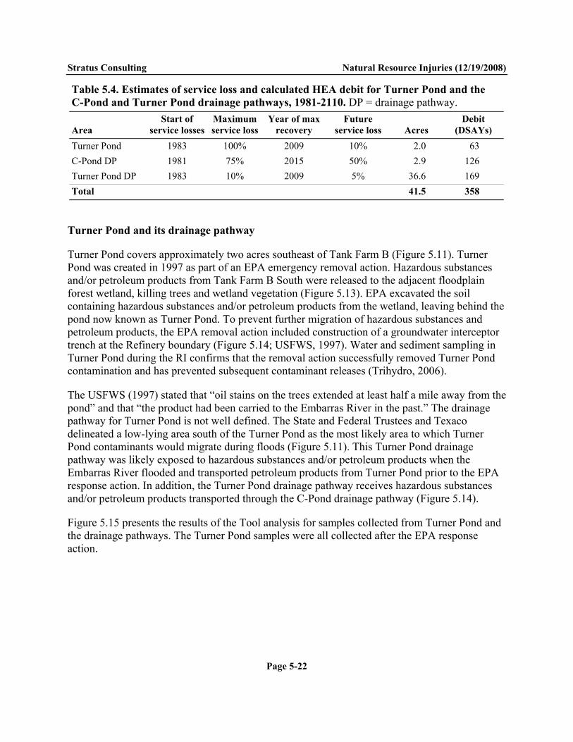
Stratus Consulting Natural Resource Injuries (12/19/2008)
Page 5-22
Table 5.4. Estimates of service loss and calculated HEA debit for Turner Pond and the C-Pond and Turner Pond drainage pathways, 1981-2110. DP = drainage pathway.
Area Start of
service losses Maximum service loss
Year of max recovery
Future service loss Acres
Debit (DSAYs)
Turner Pond 1983 100% 2009 10% 2.0 63 C-Pond DP 1981 75% 2015 50% 2.9 126 Turner Pond DP 1983 10% 2009 5% 36.6 169 Total 41.5 358
Turner Pond and its drainage pathway
Turner Pond covers approximately two acres southeast of Tank Farm B (Figure 5.11). Turner Pond was created in 1997 as part of an EPA emergency removal action. Hazardous substances and/or petroleum products from Tank Farm B South were released to the adjacent floodplain forest wetland, killing trees and wetland vegetation (Figure 5.13). EPA excavated the soil containing hazardous substances and/or petroleum products from the wetland, leaving behind the pond now known as Turner Pond. To prevent further migration of hazardous substances and petroleum products, the EPA removal action included construction of a groundwater interceptor trench at the Refinery boundary (Figure 5.14; USFWS, 1997). Water and sediment sampling in Turner Pond during the RI confirms that the removal action successfully removed Turner Pond contamination and has prevented subsequent contaminant releases (Trihydro, 2006).
The USFWS (1997) stated that “oil stains on the trees extended at least half a mile away from the pond” and that “the product had been carried to the Embarras River in the past.” The drainage pathway for Turner Pond is not well defined. The State and Federal Trustees and Texaco delineated a low-lying area south of the Turner Pond as the most likely area to which Turner Pond contaminants would migrate during floods (Figure 5.11). This Turner Pond drainage pathway was likely exposed to hazardous substances and/or petroleum products when the Embarras River flooded and transported petroleum products from Turner Pond prior to the EPA response action. In addition, the Turner Pond drainage pathway receives hazardous substances and/or petroleum products transported through the C-Pond drainage pathway (Figure 5.14).
Figure 5.15 presents the results of the Tool analysis for samples collected from Turner Pond and the drainage pathways. The Turner Pond samples were all collected after the EPA response action.

Stratus Consulting Natural Resource Injuries (12/19/2008)
Page 5-23
Figure 5.13. Turner Pond area before the emergency removal action in 1997. Petroleum products released in the adjacent tank farm were transported via groundwater and entered this wetland, killing the wetland vegetation.

Stratus Consulting Natural Resource Injuries (12/19/2008)
Page 5-24
Figure 5.14. Tank Farm B South and Turner Pond. Plume delineation by SECOR International. LNAPL is light petroleum product such as gasoline that is present atop the groundwater. Source: Trihydro, 2006.

Stratus Consulting Natural Resource Injuries (12/19/2008)
Page 5-25
Figure 5.15. Calculated service loss in samples from Turner Pond and the C-Pond and Turner Pond drainage pathways.
Stratus Consulting Natural Resource Injuries (12/19/2008)
Page 5-26
Unlike injuries in other floodplain forest areas, the injuries in Turner Pond and its drainage pathway have not been constant since 1981. Based on an analysis of aerial photographs, Tool results (Figure 5.15), and other information, the State and Federal Trustees and Texaco estimate that the release from Tank Farm B to Turner Pond started in 1983, reaching 100% service loss in 1985. Service loss remained at 100% until the EPA response was completed in 1998. In the reasonable worst-case scenario, Turner Pond services will improve to 90% of baseline by the end of 2008, with the 10% service loss remaining in perpetuity due to residual contamination. This scenario assumes that no additional remediation will occur in Turner Pond. The HEA debit for the two-acre area of Turner Pond is 63 DSAYs (Table 5.4).
For the worst-case remediation scenario in the Turner Pond drainage pathway, the State and Federal Trustees and Texaco estimated that service losses started in 1983, reached a maximum of 10% in 1985, and remained at 10% until the EPA response action was complete in 1998. Service loss will be reduced to 5% by 2009 and remain at 5% in perpetuity due to residual contamination. This reasonable worst-case scenario assumes that contaminant releases from C-Pond will be curtailed, but it assumes no remediation within the drainage pathway itself. The total HEA debit for the 36.6-acre area of the Turner Pond drainage pathway is 169 DSAYs (Table 5.4).
5.1.7 Settling Ponds
The Settling Ponds are four constructed ponds immediately south of SWMU 28/30 (Figure 5.1). Because of their location and the fact that they are man-made, baseline conditions for the Settling Ponds is floodplain forest habitat providing 100% of floodplain forest services.
The Settling Ponds received wastewater from the Refinery’s oil/water separators in the 1970s on an interim basis while the wastewater aeration ponds were constructed. Trihydro (1993) states that the Settling Ponds became operational in 1973; however, based on historical aerial photographs, it appears that three of the four ponds were constructed in the 1950s. The use of those ponds prior to 1973 is unknown. The wastewater aeration ponds were completed by 1976, at which point presumably the Settling Ponds were no longer used in the wastewater system.
Figure 5.16 shows a recent aerial photograph of the Settling Ponds and the Tool results from samples collected within and near the ponds. Vegetation encroaching into the ponds is evident in the photograph. One sediment sample in the southeast pond contained lead and some petroleum products at concentrations sufficient to cause 100% service loss. Two samples did not exceed any injury thresholds, and the remainder showed low to moderate service loss (Figure 5.16).

Stratus Consulting Natural Resource Injuries (12/19/2008)
Page 5-27
As a reasonable worst-case scenario, the State and Federal Trustees and Texaco estimate a 20% service loss for the Settling Ponds, based on the Tool information in Figure 5.16 and other information about the use of the Settling Ponds. The worst-case scenario for future injuries is a 20% service loss in perpetuity, with no reduction in service loss from site remediation. HEA debit for the 12.3 acres of the Settling Ponds was 172 DSAYs.
Figure 5.16. Calculated service loss in soil, sediment, and surface water samples from the Settling Ponds.

Stratus Consulting Natural Resource Injuries (12/19/2008)
Page 5-28
5.1.8 Southern and Firewater Ponds Floodplain Forests
The Southern Floodplain Forest is in the southeast corner of the Refinery property, and the Firewater Ponds Floodplain Forest is a small parcel of forest east of the Firewater Ponds, north of SWMU 28/30, and south of Indian Acres (Figure 5.1). Absent contamination, baseline habitat is floodplain forest that provides 100% of floodplain forest services.
Neither of these parcels of floodplain forest were part of Refinery operations. Contamination in these parcels would likely have been deposited via surface runoff or aerial deposition. The Tool results for samples in the Southern Floodplain Forest (Figure 5.17) show one sample with elevated metals concentrations immediately adjacent to the wastewater aeration ponds. Samples with low to moderate service loss and several samples with no service loss are mixed throughout the parcel. The southern and eastern Southern Floodplain Forest boundaries follow the Refinery boundary (Figure 5.17). Samples collected south and east of these boundaries showed no evidence of off-site migration of Refinery contamination.
The State and Federal Trustees and Texaco estimate a 10% service loss for the 120.2-acre Southern Floodplain Forest parcel, and assume no reduction in future service loss from site remediation. This scenario results in 846 DSAYs of HEA debit.
Three samples were collected in the Firewater Ponds Floodplain Forest, from immediately adjacent to the Firewater Ponds (Figure 5.18). The State and Federal Trustees and Texaco estimate the same service loss for this parcel as for the Southern Floodplain Forest: 10% service loss for the 12-acre parcel, with no reduction in future service loss from site remediation. This scenario results in 84 DSAYs of HEA debit.
5.2 Aquatic Habitat The State and Federal Trustees and Texaco investigated potential injury to the following aquatic habitats in and near the Refinery (Figure 5.19):
Embarras River Lime Sludge Area Ponds A tributary of Indian Creek to the west of the Refinery property Oxbow ponds south of the Southern Floodplain Forest Former Embarras River channel south of the Southern Floodplain Forest.

Stratus Consulting Natural Resource Injuries (12/19/2008)
Page 5-29
Figure 5.17. Calculated service loss in soil, sediment, and surface water samples from the Southern Floodplain Forest.

Stratus Consulting Natural Resource Injuries (12/19/2008)
Page 5-30
Figure 5.18. Calculated service loss in soil samples from the Firewater Ponds Floodplain Forest.

Stratus Consulting Natural Resource Injuries (12/19/2008)
Page 5-31
Figure 5.19. Aquatic habitat assessed for potential injury.

Stratus Consulting Natural Resource Injuries (12/19/2008)
Page 5-32
Based on a review of available data and other information, the State and Federal Trustees and Texaco determined that there has been and will be no service loss in the oxbow ponds or former Embarras River channel. Evidence of injury was found in the Lime Sludge Area Ponds and in the Embarras River. The Indian Creek tributary showed some evidence of potential injury, including metals and detectable petroleum products in sediment. However, baseline habitat conditions in the tributary are highly degraded, including a deeply incised and eroded channel and non-refinery sources of petroleum products upstream of and adjacent to the Refinery. The State and Federal Trustees and Texaco concluded that releases of hazardous substances and/or petroleum products from the Refinery, if any, were not likely to cause injury to aquatic resources in the tributary.
Lime Sludge Area Ponds
The Lime Sludge Area Ponds were used as settling ponds at the south end of the Lime Sludge Area disposal site. The outfall from the ponds had a NPDES permit in the early 1970s, but the outfall was out of compliance with the phosphate standard, and the permit was subsequently denied in 1973. The Lime Sludge Area Ponds existed prior to the construction of the Lime Sludge Area and thus baseline conditions were considered to be aquatic habitat rather than floodplain forest.
Figure 5.20 shows the results of the Tool analysis of samples from the Lime Sludge Area Ponds. Moderate service loss was found in sediment samples from the north pond. The two samples from the south pond included one with no service loss, and one with 100% service loss. Heavy metals, primarily lead and chromium, were responsible for the exceedences of injury thresholds.
Embarras River
Historically, the Embarras River near Lawrenceville meandered through a large swamp. The river has been channelized, with former swampland drained to become agricultural fields, and levees constructed to prevent flooding. Where levees are not present, the Embarras River floods regularly, with large changes in river stage common. Agricultural and petroleum industries are present upstream of the Refinery. Baseline conditions in the Embarras River likely include the presence of agricultural chemicals and petroleum products unrelated to Refinery operations.
The high energy of the Embarras River near Lawrenceville during frequent flood events likely scours the river channel, preventing long-term deposition of contaminated sediment. Surface water and sediment samples collected from the river during the RI showed little evidence of ongoing contamination in the Embarras River. Thus, most of the evidence of injury to the Embarras River is based on known releases to the river such as exceedences of NPDES criteria in wastewater outflow. There are no published reports of large oil spills or fish kills in the
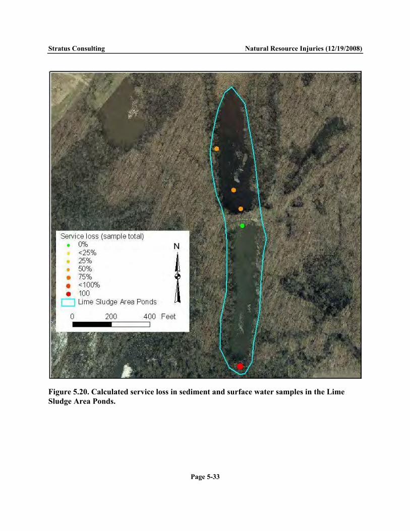
Stratus Consulting Natural Resource Injuries (12/19/2008)
Page 5-33
Figure 5.20. Calculated service loss in sediment and surface water samples in the Lime Sludge Area Ponds.

Stratus Consulting Natural Resource Injuries (12/19/2008)
Page 5-34
vicinity of the Refinery. The ultimate fate of the releases of hazardous substances and/or petroleum products into the Embarras River is unknown and is not likely to be obtainable at a reasonable cost.
The following is a summary of known releases to the Embarras River:
Three recorded incidents of small oil spills into the Embarras River or into drainage ditches that lead to the Embarras River in 1995
Regular exceedences of NPDES permitted concentrations of hazardous substances in the wastewater treatment system outfalls, including at least 79 reported violations from Outfall 001 between 1980 and 2003, according to IEPA files
Petroleum product releases from Indian Acres to the Embarras River from 1996 through 2005, following the City of Lawrenceville’s improper and unpermitted installation of a storm sewer through Indian Acres
Releases from Turner Pond during flood events prior to the EPA response action in 1997
Releases from C-Pond into the C-Pond drainage pathway and ultimately to the Embarras River during flood events.
To compensate for these injuries, the State and Federal Trustees and Texaco agreed on an aquatic habitat restoration project that will offset the injuries to aquatic habitat (Chapter 6). The State and Federal Trustees and Texaco qualitatively determined that the magnitude and timing of habitat benefits from the aquatic restoration project would offset the magnitude and timing of aquatic injuries.
5.3 Resources within the Refinery Footprint The Refinery footprint is the area in which Refinery infrastructure, such as buildings, roads, process areas, wastewater treatment plants, pipe racks, and tanks, was present prior to the start of demolition of the Refinery in 1998. These areas are not considered typical habitat, and thus a HEA approach to injury quantification is not appropriate. However, releases of hazardous substances and/or petroleum products within the industrial footprint injured Trustee biological resources including birds and wildlife.
The USFWS (1997) discovered dead birds covered with oil at multiple locations on the Refinery property in June 1997. At the time of the site inspection, USFWS investigators found 17 oiled bird remains in a large exposed oil collection pit (Separator #7) on the eastern side of the Refinery, and another four oiled bird remains at C-Pond, at the southern end of the Refinery

Stratus Consulting Natural Resource Injuries (12/19/2008)
Page 5-35
(Figure 2.2). The 21 dead birds included nine rock doves (Columba livia), one mourning dove (Zenaida macroura), two brown thrashers (Toxostoma rufum), two red-winged blackbirds (Agelaius phoeniceus), two common grackles (Quiscalus quiscula), two green-backed herons (Butorides virescens, or B. striatus), one redhead (Aythya americana), one American robin (Turdus migratorius), and one wood duck (Aix sponsa). Bird exclosures were subsequently constructed to prevent avian access to the collection pit.
During a 2003 herpetological survey, ELM Consulting (2003) found approximately 61 dead birds and one dead snake trapped in a thick, black, asphaltic material located on the ground surface throughout Tank Farm A, west of Indian Acres (Figure 5.21). The dead birds comprised four European starlings (Sturnus vulgaris), three northern cardinals (Cardinalis cardinalis), 26-29 common grackles, three house sparrows (Passer domesticus), five red-winged blackbirds, and 15-17 unidentifiable bird species. The dead snake was a common garter snake (Thamnophis sirtails). Texaco contractors covered the oily waste with plywood to prevent avian contact, then subsequently removed the oily waste as part of Tank Farm A demolition.
Figure 5.21. Bird mortality in Tank Farm A, 2003. Source: ELM Consulting, 2003.

Stratus Consulting Natural Resource Injuries (12/19/2008)
Page 5-36
The State and Federal Trustees and Texaco were unable to find other recorded evidence of mortality at the Refinery. However, until the implementation of a remedy at the site, Trustee natural resources will continue to be exposed to petroleum wastes in areas such as the tank farms or C-Pond. These wastes are likely to cause injuries to natural resources within the Refinery footprint.
Based on available data, the State and Federal Trustees and Texaco concluded that the development of wildlife mortality models and resource equivalency analyses would not be cost-effective given the apparent amount of injury. The State Trustees and Texaco instead agreed on restoration projects/concepts to offset the injuries within the Refinery footprint (Chapter 6).
5.4 Groundwater Groundwater underlying the Refinery has been monitored extensively as part of RI activities. This section includes data presented in the draft groundwater SPE as well as data from the Refinery environmental database (Trihydro, 2006).
Light non-aqueous phase liquid (LNAPL) has been found on top of the groundwater at multiple wells at the Refinery, indicating migration of petroleum products from the Refinery to the groundwater. According to the SPE, the specific gravities and boiling ranges of the LNAPL indicate a variety of petroleum products have been released to groundwater, ranging in weight from gasoline to heavier diesel.
Groundwater from wells with LNAPL present generally was not sampled for chemical analysis to avoid potential contamination from LNAPL during sampling. The presence of LNAPL in a well is evidence that the groundwater in that location is contaminated. Furthermore, dissolved hazardous substances such as metals and BTEX have been found in many wells where LNAPL did not prevent sampling.
The State and Federal Trustees and Texaco compiled the groundwater data from the environmental database and displayed the spatial extent of LNAPL plumes (SECOR International et al., 2004b) and exceedences of groundwater quality criteria using GIS. Inorganic chemistry data in groundwater showed widespread exceedences of drinking water criteria for lead throughout the Refinery property. Because the NRDA was conducted concurrently with the RI, Texaco contractors addressed the widespread lead exceedence question in the RI by installing upgradient background wells and changing to a low-flow sampling technique. The combined results indicated that the lead in the groundwater samples was likely from aquifer materials flushed into the samples during well pumping, rather than lead dissolved in the groundwater.

Stratus Consulting Natural Resource Injuries (12/19/2008)
Page 5-37
Groundwater underlying the Refinery would be potable absent the release of hazardous substances and/or petroleum products. Injured groundwater was quantified based on LNAPL plumes and exceedences of drinking water quality thresholds for organic contaminants (excluding phthalates) at the Refinery (Figure 5.22). Most of the exceedences shown in Figure 5.22 are for petroleum contaminants such as BTEX and PAHs. The areal extent of injured groundwater in Figure 5.22 is approximately 255 acres.
The USFWS (1997) reported that approximately 11 million gallons of contaminated water was pumped to the oil/water separator during the 16 months of removal activities during the Turner Pond response, indicating that the total annual flux of contaminated groundwater site-wide is likely to be high.
The Trustees used the spatial extent of the plume and other qualitative information to scale appropriate restoration projects to offset groundwater injury (Chapter 6). The existing groundwater intercept structures along the Refinery boundary are likely to continue to contain the groundwater plumes. If Texaco successfully removes leaking underground pipes in 2008 as planned, it is likely that the onsite groundwater plumes will be reduced. However, as a worst-case scenario for scaling restoration, the Trustees assumed that any additional remedial actions would not reduce the size of the plumes onsite.
5.5 Summary Injuries to Trustee natural resources at the Refinery were determined and quantified separately for floodplain forest habitat, aquatic habitat, natural resources within the Refinery footprint, and groundwater.
The State and Federal Trustees and Texaco used HEA to quantify injuries to floodplain forest habitat. The total estimated service loss in floodplain forest habitat is 8,764 DSAYs (Table 5.5), based on reasonable worst-case scenarios for past and future interim losses. The total area of injured floodplain forest habitat is 353 acres (Table 5.5).
Injuries to surface water resources were determined for the Lime Sludge Areas Ponds and the Embarras River. However, injuries to the Embarras River are difficult to quantify. Some injuries occurred in the past and were ephemeral, with limited data available for injury quantification. The high energy of the Embarras River during floods likely scours sediment, removing evidence of past and ongoing releases to sediment. Since no data are available to quantify the injuries from most releases, the State and Federal Trustees and Texaco proposed an aquatic habitat restoration project that all parties agreed would offset aquatic injuries (Chapter 6) without developing a scaling model.

Stratus Consulting Natural Resource Injuries (12/19/2008)
Page 5-38
Figure 5.22. Spatial extent of groundwater injury at the Refinery, based on LNAPL plumes and the exceedences of injury thresholds for organic contaminants.

Stratus Consulting Natural Resource Injuries (12/19/2008)
Page 5-39
Table 5.5. Summary of floodplain forest habitat area injuries and service loss
Description Area
(acres)
Baseline floodplain
forest services
Maximum service loss, 1981-2009
Estimated future service loss, 2010-2110a
HEA debit
(DSAYs)Indian Acres: west side, high impact 12.4 50% 100% 100% → 50% 382 Indian Acres: west side, moderate impact 14.1 50% 75% 75% 248 Indian Acres: east side, high impact 12.8 100% 100% 100% → 50% 848 Indian Acres: east side, moderate impact 10.8 100% 62.5% 100% → 50% 552 Indian Acres: east side, low impact 11.0 100% 25% 25% 290 SWMU 28 and SWMU 30 15.9 100% 100% 100% 925 SWMU 9 North, northern portion 13.7 100% 100% 100% 964 SWMU 9 North, flare tower area 9.3 50% 75% 75% 164 SWMU 9 South 11.0 100% 50% 50% 387 Lime Sludge Area 55.6 100% 65% 65% 2,542 Turner Pond 2.0 100% 100% 10% 63 Turner Pond drainage pathway 36.6 100% 10% 5% 169 C-Pond drainage pathway 2.9 100% 75% 75% → 50% 126 Settling Ponds 12.3 100% 20% 20% 172 Southern Floodplain Forest 120.2 100% 10% 10% 846 Firewater Ponds Floodplain Forest 12.0 100% 10% 10% 84 Totalb 353 8,764 a. Under reasonable worst-case remediation scenarios, it is assumed that some waste in Indian Acres will be capped in place, and that discharges to C-Pond drainage pathway will be curtailed. At all other sites, it is assumed that the selected remedy will be monitored attenuation with no cleanup. b. Total may not equal sum of above due to rounding.
Some wildlife mortality, primarily to birds, has been documented within the Refinery footprint. Trustee wildlife resources continue to be exposed to hazardous substances and/or petroleum products within the Refinery, in areas such as tank farms and C-Pond where oily wastes are present. The State and Federal Trustees and Texaco used the available information on past bird and wildlife mortalities to develop restoration projects/concepts that offset the injuries within the Refinery footprint (Chapter 6).
Hazardous substances and/or petroleum products from spills and leaking tanks and pipes have injured groundwater resources under the Refinery. Based on exceedences of organic contaminant injury thresholds (mostly petroleum-derived contaminants) and estimates of the extent of LNAPL plumes, the Trustees estimated that the spatial extent of groundwater injury at the Refinery is approximately 255 acres.

6. Damage Determination The State and Federal Trustees and Texaco used a restoration-based approach to damage determination, where restoration actions compensate the public for past, ongoing, and future natural resource injuries as a result of hazardous substances and/or petroleum product releases at the Refinery. Specifically, they developed appropriate habitat and resource conservation and restoration projects to offset the injuries summarized in Chapter 5. These projects include the conservation and restoration of substantial floodplain forest along the Embarras River downstream of the Refinery, and projects to improve groundwater recharge and reduce groundwater use and contamination in the Lawrenceville area. These conservation and restoration projects, which are in addition to site remediation activities conducted pursuant to the RI/FS, will make the public whole for past, ongoing, and future natural resource injuries.
Section 6.1 describes projects to offset floodplain forest habitat injuries and includes a calculation of the HEA credit for the projects. Section 6.2 describes restoration projects to offset groundwater injuries, including floodplain forest habitat conservation that will preserve groundwater recharge, and projects to reduce groundwater use and groundwater contamination in the Lawrenceville area. Section 6.3 describes an aquatic restoration project to offset aquatic habitat injuries, Section 6.4 describes additional on-site restoration to offset injuries to Trustee resources within the Refinery footprint, and Section 6.5 describes the anticipated costs of the restoration projects. Finally, Section 6.6 presents a summary of the damages, including all restoration projects, land acquisitions, and project costs.
6.1 Floodplain Forest Habitat Projects Injuries to floodplain forest habitat resulted in 8,764 DSAYs of HEA debit, based on reasonable worst-case scenarios described in Chapter 5. An equivalent amount of HEA credit from floodplain forest acquisition and restoration projects is required to offset these injuries.
The State and Federal Trustees and Texaco targeted conservation and restoration of floodplain forest habitat downstream of (and not contaminated by) the Refinery as the most appropriate and cost-effective restoration for the floodplain forest injuries. This preference was based on numerous selection criteria, including nexus and proximity to the injured habitat, availability of the land parcels, and the cost of acquisition and restoration (see Appendix A, Table 5.1). Three separate land parcels were identified for conservation and restoration projects: the Siddens property, the AWR property, and the White Farm (Figure 6.1).
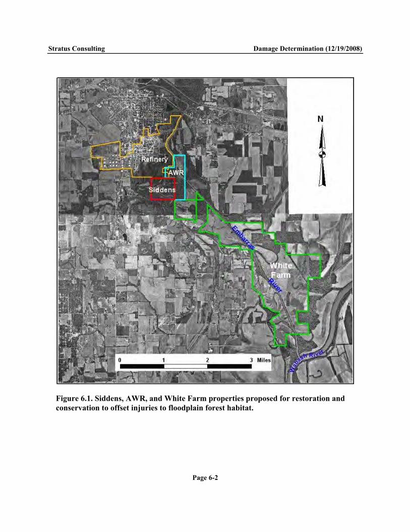
Stratus Consulting Damage Determination (12/19/2008)
Page 6-2
Figure 6.1. Siddens, AWR, and White Farm properties proposed for restoration and conservation to offset injuries to floodplain forest habitat.

Stratus Consulting Damage Determination (12/19/2008)
Page 6-3
HEA credit for these properties is generated both by enhancing the habitat services through habitat restoration and by avoided adverse future land uses through habitat conservation. The following sections discuss calculations of HEA credit for these floodplain forest properties.
6.1.1 Avoided adverse land use – Siddens and AWR properties
HEA credit for the floodplain forest properties includes conservation credit for preventing future adverse land use. Potential land uses for floodplain forests in Lawrence County include leaving the parcels as unmanaged forest, resource harvesting such as agriculture or logging, and land development for private hunt clubs. The State and Federal Trustees and Texaco considered the probability of each of these land use scenarios in the calculations of HEA credit for avoided adverse land use.
The State and Federal Trustees and Texaco formed a restoration working group (RWG), including IDNR regional restoration ecologists and biologists with extensive knowledge of the floodplain forest habitat in the area, to assess current and estimate future floodplain habitat services at the Siddens and AWR properties (e.g., Basinger and Edgin, 2006). Using GIS, aerial photographs, and field reconnaissance, the RWG identified eight land units within the Siddens and AWR properties, based on past land use and current habitat (Figure 6.2). Current land uses include agricultural fields that have recently gone fallow, former agricultural fields in various stages of succession to floodplain forest, and mature floodplain forest. The RWG conducted surveys of the eight units, estimating the current level of habitat services in each unit relative to baseline floodplain forest.
Current floodplain forest habitat services for land units in Siddens and AWR range from 50% of baseline services for the fallow agricultural field on the east bank of the Embarras River (Unit 7) to 100% of baseline services for the mature floodplain forest units (Units 3, 4, and 6). Units 2 and 5 are in early succession, providing an estimated 60% of baseline services, and Units 1 and 9 are in mid-succession, providing an estimated 75% of baseline services.1 Table 6.1 presents the area of each land unit and the current services provided. The eight land units within the Siddens and AWR parcels comprise 328 acres.2 The weighted average services for the entire 328 acres are 83% of baseline floodplain forest services (Table 6.1).
1. Unit 8 is the Embarras River, which is not included in this analysis of floodplain forest habitat services.
2. The GIS files of the Siddens and AWR properties provided to the RWG for evaluating restoration projects and HEA credit covered 328 acres for the combined parcels. This is a minimum acreage – the actual acreage needs to be verified and may be greater than 328 acres.

Stratus Consulting Damage Determination (12/19/2008)
Page 6-4
Figure 6.2. Habitat units in the Siddens and AWR parcels, based on current and potential future habitat condition and land use. The current habitat services and total size of each unit are shown in Table 6.1, except for the Embarras River (Unit 8), which is not included in the floodplain forest habitat analysis.
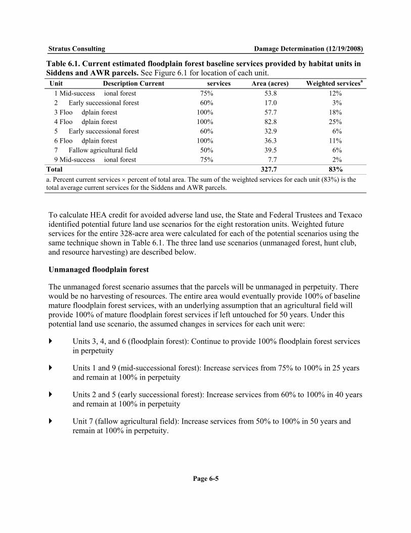
Stratus Consulting Damage Determination (12/19/2008)
Page 6-5
Table 6.1. Current estimated floodplain forest baseline services provided by habitat units in Siddens and AWR parcels. See Figure 6.1 for location of each unit. Unit Description Current services Area (acres) Weighted servicesa
1 Mid-success ional forest 75% 53.8 12% 2 Early successional forest 60% 17.0 3% 3 Floo dplain forest 100% 57.7 18% 4 Floo dplain forest 100% 82.8 25% 5 Early successional forest 60% 32.9 6% 6 Floo dplain forest 100% 36.3 11% 7 Fallow agricultural field 50% 39.5 6% 9 Mid-success ional forest 75% 7.7 2%
Total 327.7 83% a. Percent current services percent of total area. The sum of the weighted services for each unit (83%) is the total average current services for the Siddens and AWR parcels.
To calculate HEA credit for avoided adverse land use, the State and Federal Trustees and Texaco identified potential future land use scenarios for the eight restoration units. Weighted future services for the entire 328-acre area were calculated for each of the potential scenarios using the same technique shown in Table 6.1. The three land use scenarios (unmanaged forest, hunt club, and resource harvesting) are described below.
Unmanaged floodplain forest
The unmanaged forest scenario assumes that the parcels will be unmanaged in perpetuity. There would be no harvesting of resources. The entire area would eventually provide 100% of baseline mature floodplain forest services, with an underlying assumption that an agricultural field will provide 100% of mature floodplain forest services if left untouched for 50 years. Under this potential land use scenario, the assumed changes in services for each unit were:
Units 3, 4, and 6 (floodplain forest): Continue to provide 100% floodplain forest services in perpetuity
Units 1 and 9 (mid-successional forest): Increase services from 75% to 100% in 25 years and remain at 100% in perpetuity
Units 2 and 5 (early successional forest): Increase services from 60% to 100% in 40 years and remain at 100% in perpetuity
Unit 7 (fallow agricultural field): Increase services from 50% to 100% in 50 years and remain at 100% in perpetuity.

Stratus Consulting Damage Determination (12/19/2008)
Page 6-6
Weighting these scenarios by area results in a site-wide average of 20 years to increase services from 83% to 100%, with services remaining at 100% in perpetuity. The probability of this unmanaged forest scenario was estimated to be 50%, based on specific factors such as the location of and available access to the Siddens and AWR parcels, as well as general factors such as the current land use practices in other Embarras River floodplain forest areas.
Hunt club
The hunt club scenario assumes that the parcels will be manipulated to improve hunting and facilitate access for hunters. Units 5 and 7 will be converted to open fields to attract wildlife. The other units would be managed to remain in various states of successional forest. Specifically, the assumed changes in services for each unit were:
Units 3, 4, and 6 (floodplain forest): Reduce services from 100% floodplain forest services to 75% services in 10 years and remain at 75% in perpetuity
Units 1 and 9 (mid-successional forest): Continue to provide 75% services in perpetuity
Unit 2 (early successional forest): Increase services from 60% to 75% in 10 years and remain at 75% in perpetuity
Units 5 and 7 (early successional forest and fallow agricultural field): Decrease services from 50% (Unit 7) or 60% (Unit 5) to 30% in two years and remain at 30% in perpetuity.
Weighting these scenarios by area results in a site-wide average of six years to decrease services from 83% to 65%, with services remaining at 65% in perpetuity. The probability of this hunt club scenario occurring if the land is not conserved is estimated to be 30%.
Resource harvesting
The harvesting scenario (farming and logging) assumes that Units 5 and 7 will return to active agriculture, and the remaining units will be floodplain forest managed for logging. Logging scenarios assume that the trees require 50 years to reach maturity after each logging event, and then the forest is logged again. The assumed changes in services for each unit are:
Units 3, 4, and 6 (floodplain forest): Reduce services from 100% floodplain forest services to 60% services in one year after logging, increase services to 100% over 50 years, and then repeat the logging cycle
Units 1 and 9 (mid-successional forest): Reduce services from 75% floodplain forest services to 60% services in one year after selective logging, increase services to 100% over 50 years, and then repeat the logging cycle

Stratus Consulting Damage Determination (12/19/2008)
Page 6-7
Unit 2 (early successional forest): Increase services from 60% to 100% over 50 years, and then start the logging cycle
Units 5 and 7 (early successional forest and fallow agricultural field): Decrease services from 50% (Unit 7) or 60% (Unit 5) to 30% in one year and remain at 30% in perpetuity.
Weighting these scenarios by area results in a site-wide average decrease in services from 83% to 53% in one year after initial logging, with services increasing to 85% after 50 years, then decreasing to 53% again at the start of the next logging cycle. The probability of this harvesting scenario occurring if the land is not conserved is estimated to be 20%.
Section 6.1.4 describes the calculation of HEA credit for each of these future use scenarios.
6.1.2 Restoration of floodplain habitat – Siddens and AWR properties
After consultation with IDNR regional natural resources experts in the RWG, the State and Federal Trustees and Texaco developed a suite of restoration projects for the Siddens and AWR properties (Figure 6.3). These restoration actions will enhance habitat quality in the floodplain forest to levels exceeding baseline services for unmanaged floodplain forest (i.e., the restored habitat will provide greater than 100% of baseline habitat services). Proposed restoration actions include basic floodplain forest improvements such as tree planting and riparian buffers to reduce erosion. Other proposed projects are described in a restoration conceptual plan developed as part of the cooperative NRDA process (Appendix G). Below is a brief description of some of the proposed floodplain forest restoration projects.
Forest improvement
Forest improvement includes the removal of less desirable tree species, improving conditions for desirable tree species, and thinning trees to desirable densities. Forest improvement enhances wildlife habitat and the appearance and health of the forest. Periodic thinning can improve tree quality and reduce the time span to reach maturity. After thinning, the remaining trees usually increase nut or seed production. This provides additional food for wildlife and a seed source for the next generation of trees. More open space between tree crowns also encourages larger crowns with more nut production and understory growth for wildlife (Missouri Department of Conservation, 2006).
A well-managed forest enhances a watershed by absorbing most of the incoming precipitation, reducing soil erosion, replenishing groundwater, and stabilizing the flows of springs. Thinned forests have more moisture and growing room available, allowing vigorously growing trees to withstand stresses caused by insects, disease, and drought (Missouri Department of Conservation, 2006).

Stratus Consulting Damage Determination (12/19/2008)
Page 6-8
Figure 6.3. Proposed habitat restoration in the Siddens and AWR parcels. Source: Restoration Conceptual Plan (Appendix G, Figure 2).

Stratus Consulting Damage Determination (12/19/2008)
Page 6-9
Depressional habitat enhancement
Depressional habitat includes vernal pools and shallow, temporary wetlands. This habitat is important as breeding and rearing habitat for amphibians, crustaceans, and insects (Biebighauser, 2003). Approximately one-half of all frogs and one-third of all salamander species rely on seasonal or temporary wetlands for development (Biebighauser, 2003). Depressional habitat also provides benefits for migratory birds, reptiles, and mammals, especially as feeding and resting areas during migration.
To improve depressional habitat within the Siddens and AWR parcels, cut trees from forest improvement activities would be placed in depressional areas. In addition, some excavation of depressions would be conducted to increase water storage capacity and provide areas of standing water through dry periods.
Canebrake restoration
Giant cane (Arundinaria gigantean) is a perennial bamboo species historically found in vast areas of southeastern Illinois floodplains prior to European settlement (Campbell, 1985; Platt and Brantley, 1997). Mature cane forms into dense monotypic stands known as canebrakes.
Canebrake is considered to be a critically endangered ecosystem, reduced to less than 2% of its former extent (Noss et al., 1995). Canebrakes are critical habitat for several species. In addition, cane growing in riparian buffers enhances water quality and stabilizes stream banks, reducing nitrates and sediments in groundwater and overland flow (Schoonover, 2001; Schoonover and Williard, 2003).
The State and Federal Trustees and Texaco identified several openings in the floodplain forest on the Siddens and AWR properties that would benefit from canebrake restoration (Figure 6.3). As part of habitat enhancement in these areas, canebrakes will be planted and maintained, thus providing critical canebrake habitat. Appendix G discusses the benefits of canebrake restoration in more detail.
Sensitive species enhancement/reintroduction
Proposed restoration actions also include habitat enhancements and species reintroductions for sensitive species, including the copperbelly water snake (Nerodia erythrogaster neglecta), bloodleaf (Iresine rhizomatosa), storax (Styrax americana), and alligator snapping turtle (Macrochelys temminckii). Habitat enhancements include wetland creation and conservation, habitat buffer strip creation, and forest improvements in uplands. Translocation of bloodleaf, storax, and the alligator snapping turtle may be implemented in concert with other ongoing reintroduction efforts in Illinois.

Stratus Consulting Damage Determination (12/19/2008)
Page 6-10
6.1.3 White Farm
The White Farm is a large parcel of land encompassing most of the Embarras River floodplain between the Siddens/AWR parcels and the confluence with the Wabash River (Figure 6.1). Conservation of the 1,954 acres of White Farm plus the 328 acres of Siddens and AWR properties would provide a large, nearly continuous corridor of protected floodplain forest habitat between the Refinery and the mouth of the Embarras River.
The White Farm is currently in the Federal wetlands reserve program (WRP), where the landowners received financial compensation to restore, protect, and enhance wetlands in exchange for retiring the land from agriculture. Because of the commitment to the WRP, the avoided adverse use credit for this land is less than for Siddens and AWR properties.
Detailed restoration plans have not yet been developed for the White Farm. It is anticipated that habitat restoration actions similar to those at the Siddens and AWR properties, such as timber stand and depressional habitat enhancements, canebrake restoration, and threatened species translocation, will be conducted at White Farm to enhance floodplain forest habitat services.
6.1.4 HEA credit
Baseline services for the Siddens and AWR properties are 100% unmanaged floodplain forest habitat services. Credit is earned for preventing the properties from becoming harvested or becoming a hunt club, as well as for restoration projects that improve habitat services above baseline. The full benefits of floodplain forest restoration would occur after 50 years, after full tree canopies develop in the forest. Services would improve linearly from the current weighted average floodplain services of 83% to 120% after 50 years.
Total HEA credit for conservation and restoration of the Siddens and AWR properties from 2008 through 2110 is 2,066 DSAYs (Table 6.2). Credit for conservation of the property (1,499 DSAYs) covers the entire 328 acres. Credit for restoration projects (568 DSAYs) covers 311 acres, reserving 17 acres of aquatic habitat to be restored as compensation for aquatic habitat injuries (Section 6.2). Credit for conservation is 4.6 DSAYs per acre, and credit for habitat restoration is 1.8 DSAYs per acre, providing a total of 6.4 DSAYs per acre of credit at the Siddens and AWR properties.
Because the White Farm is in the WRP and thus adverse future land use is less likely, HEA credit for conservation and restoration of White Farm is estimated as 75% of the per-acre credit for the Siddens and AWR properties, or 4.8 DSAYs/acre.

Stratus Consulting Damage Determination (12/19/2008)
Page 6-11
Table 6.2. HEA credit for conservation and restoration of the Siddens and AWR properties, 2008-2110. Services are weighted average services for the entire 328-acre property. Credits calculated through 2110, after which credit is near zero because of discounting.
Scenario Start year
Start services
End year
End services Likelih ood
Credit (DSAYs)
Unmanaged foresta 2008 83% 2027 100% 50% – 20 28 100% 2110 100% 50% – Hunt club 2008 83% 2013 65% 30% 67.3 20 14 65% 2110 65% 30% 819.1 Resource harvesting 2008 83% 2009 53% 20% 28.2 20 10 53% 2059 85% 20% 461.8 20 60 53% 2110 85% 20% 121.4
2008 83% 2057 120% – 204 Multiple restoration projects 2058 12 0% 2110 120% – 364 Total 2,066 a. Unmanaged forest is the baseline condition – there is no adverse land use for this scenario. Credit is earned for the hunt club and harvesting scenarios each year that their weighted average services are less than the unmanaged forest scenario, and credit is earned for the restoration projects each year that weighted average services are greater than the unmanaged forest scenario.
Table 6.3 summarizes the conservation and restoration necessary to offset floodplain forest habitat injuries. Conservation and restoration of all of the Siddens and AWR properties at 6.4 DSAYs per acre, as well as 1,395 acres of the White Farm at 4.8 DSAYs per acre, will offset the floodplain forest habitat injuries.
Table 6.3. HEA credit for floodplain forest habitat conservation and restoration
Property/ project Acres Summary of HEA credit inputs
HEA credits per acre (DSAYs)
Total HEA credits
(DSAYs) Siddens/AWR habitat conservation and restoration
328 Improvement to 120% services in 50 years through active restoration of floodplain forest habitat Land conservation preventing future adverse land uses such as logging, farming, or hunt club development
6.4 2,070
White Farm habitat conservation and restoration (portion)
1,395 Avoidance of future adverse land use through conservation plus active restoration of floodplain forest habitat Per-acre credit is 75% of AWR/Siddens
4.8 6,694
Total credits 8,764

Stratus Consulting Damage Determination (12/19/2008)
Page 6-12
6.2 Groundwater Restoration Projects
The State and Federal Trustees and Texaco convened a groundwater working group (GWWG) to evaluate many different groundwater restoration options. The GWWG included employees of the Illinois State Water Survey, the Illinois State Geological Survey, and the Illinois Department of Public Health who provide research and technical assistance on groundwater issues for the State, as well as contractors conducting the groundwater investigations at the Refinery. The GWWG evaluated many compensatory restoration options for groundwater. The selected options described below will compensate for the injuries to groundwater at the Refinery (see Chapter 5).
6.2.1 Groundwater protection – White Farm
Groundwater protection is the preservation of groundwater recharge areas at the surface to prevent future adverse effects on groundwater quality and reduced groundwater infiltration. Nitrate and pesticide contamination are common shallow groundwater problems in Lawrence County. Eliminating the use of fertilizers and pesticides at the ground surface and preventing mineral extraction protects groundwater quality in the future. In addition, active harvesting of resources, including logging and farming, can increase surface runoff, thus reducing the quantity of precipitation that infiltrates to groundwater.
As described in Section 6.1, approximately 1,395 acres of the 1,954-acre White Farm property (Figure 6.1) are proposed as compensation for floodplain forest habitat injuries. The remaining 559 acres (1,954-1,395) of White Farm is partial compensation for groundwater injuries. The State will ensure that the White Farm is protected against future land uses that would adversely affect groundwater quality and quantity. Restoration activities on White Farm will also increase groundwater recharge and improve groundwater quality. The 559 acres of protected White Farm habitat is more than twice the area of the 255-acre groundwater plume at the Refinery.
6.2.2 Reduced groundwater contamination – best management practice seminars
Shallow groundwater contamination from fertilizer and pesticide use is a common problem in Lawrence County. To reduce this contamination in the future, the University of Illinois Extension will present several best management practice (BMP) seminars in the Lawrenceville area. These seminars will provide local farmers with fertilizer and pesticide management options that result in high crop yields while reducing fertilizer and pesticide use. Reduced fertilizer and pesticide use will ultimately benefit groundwater quality in the area, as less fertilizer and pesticide will be transported through the unsaturated soils to shallow groundwater, although the degree and spatial extent of these groundwater improvements are difficult to quantify.

Stratus Consulting Damage Determination (12/19/2008)
Page 6-13
6.2.3 Reduced groundwater consumption – Supervisory Control and Data Acquisition system
The City of Lawrenceville provides drinking water to its citizens from shallow alluvial groundwater pumped from wells approximately three miles east of the city (Figure 6.4). The City’s current groundwater acquisition system uses outdated technology. Groundwater pumping rates are set manually at the start of each season, with the rate set at the highest estimated demand. Whenever actual demand is less than the estimated peak demand for the season, the City is pumping and treating more water than is necessary, with excess water discharged to surface water.
Supervisory Control and Data Acquisition (SCADA) systems are electronic controls that adjust groundwater pumping rates to meet demand in real time. SCADA systems can also monitor water distribution systems, detecting when leaks occur. Installation of SCADA controls for the City of Lawrenceville’s water system will greatly reduce excess groundwater pumping from the alluvial aquifer. Reduced groundwater usage serves as partial compensatory restoration for groundwater injuries at the Refinery.
6.3 Aquatic Habitat Restoration Releases of hazardous substances and/or petroleum products from the Refinery injured aquatic habitat such as the Lime Sludge Area Ponds and the Embarras River (see Chapter 5). The State Trustees and Texaco are evaluating aquatic habitat restoration projects to offset the injuries. One potential project involves restoration of two oxbow ponds near the southeastern border of the Refinery property that provide approximately 20 acres of aquatic habitat in the Embarras River floodplain forest (Figure 6.5). These ponds are valuable amphibian and reptile habitat, with high productivity and abundant woody debris. In addition, during Embarras River floods, these ponds become hydraulically connected to the river, providing refuge from floodwaters to riverine aquatic species as well as habitat to these species after the river recedes.
Field reconnaissance revealed that silt may adversely affect these oxbow ponds, and that erosion at the downstream end of the ponds could potentially cause the ponds to drain into the surrounding forest, thus destroying the aquatic habitat. The State and Federal Trustees and Texaco investigated restoration options such as water control structures and dredging of silt to potentially restore the aquatic habitat and prevent the erosion and eventual failure of the downstream banks of the ponds. The State Trustees and Texaco continue to investigate such measures.

Stratus Consulting Damage Determination (12/19/2008)
Page 6-14
Figure 6.4. City of Lawrenceville drinking water supply well field.

Stratus Consulting Damage Determination (12/19/2008)
Page 6-15
Figure 6.5. Oxbow ponds that will be restored to offset injuries to aquatic habitat.

Stratus Consulting Damage Determination (12/19/2008)
Page 6-16
Restoration and conservation of these oxbow ponds will offset injuries to aquatic habitat. Most of the area of the oxbow ponds is on the Siddens property, which will be conserved as compensation for floodplain forest habitat injuries (see Section 6.1), thus ensuring that ponds will be protected in the future. The Restoration Plan will describe the anticipated restoration activities in more detail.
6.4 On-site Restoration
As described in Chapter 5, the State and Federal Trustees and Texaco concluded that the amount of natural resource injuries within the Refinery industrial footprint was not likely sufficient to warrant the development of a resource-to-resource resource equivalency analysis (REA) model. To address natural resource injuries within the Refinery footprint, it was agreed that it is appropriate to consider creation of habitat through ecological revitalization as a complement or enhancement of remedial alternatives in the FS, to the extent reasonable, technically feasible, cost-effective, and consistent with the IEPA-approved remedy and the proposed future use of the property. Specifically, consistent with the vision presented in the 2006 Illinois Comprehensive Wildlife Conservation Plan and Strategy, Texaco will, in its discretion, identify and evaluate in the FS such approaches as promoting the establishment of native vegetation, the incorporation of opportunities for passive recreation, and the incorporation or creation of appropriate avian, aquatic or terrestrial habitats.
6.5 Restoration Costs
The State and Federal Trustees and Texaco developed unit costs for restoration projects at the Siddens and AWR properties, including costs for floodplain forest projects such as timber stand improvement, depressional habitat enhancements, species translocation, and canebrake restoration; aquatic restoration projects at the oxbow ponds; and the SCADA and BMP groundwater restoration projects. The proposed projects were found to be both cost-effective and feasible. The specific details of the cost analysis will be published in a Restoration Plan.
The State Trustees examined the suite of restoration options and anticipated the improvements in floodplain forest and aquatic habitat services that would occur as a result of restoration. In total, they estimated that $1,362,000 is required to make the public whole, paying for:
Active floodplain forest restoration, sufficient to raise floodplain habitat services to 120% of baseline over 50 years, at the Siddens and AWR properties and on 1,395 acres of the White Farm property
Restoration of the oxbow ponds

Stratus Consulting Damage Determination (12/19/2008)
Page 6-17
Additional restoration, acquisition, and/or preservation of floodplain forest, to cover the uncertainty in the restoration benefits and cost analyses.
In addition, the State Trustees estimated that $115,000 would be required for the SCADA and the BMP seminars.
The following section summarizes the proposed settlement, including the restoration costs. The Restoration Plan will describe anticipated unit costs for restoration and discuss in more detail the anticipated allocation of restoration settlement money.
6.6 Summary
To make the public whole for injuries to natural resources as a result of hazardous substance and/or petroleum product releases, Texaco will acquire floodplain forest habitat and transfer the land to the State. In addition, Texaco will provide funding for habitat restoration, additional land acquisition, and projects to reduce groundwater consumption and improve groundwater quality in Lawrence County. Table 6.4 summarizes the proposed agreement between Texaco and the State Trustees.

Stratus Consulting Damage Determination (12/19/2008)
Page 6-18
Table 6.4. Proposed settlement between the State Trustees and Texaco to compensate for natural resource injuries at the Refinery Project Description Cost/property
Siddens acquisition
Provide Siddens property to the State for permanent habitat conservation 160 acresa
AWR acquisition Provide AWR property to the State for permanent habitat conservation 20 0 acresa
White Farm acquisition
Provide White Farm property to the State for permanent habitat conservation 1,9 54 acres
Land acquisition and conservation subtotal 2,314 acres Habitat restoration and additional land acquisitionb
Restoration of floodplain forest habitat on Siddens, AWR, and White Farm properties; restoration of aquatic habitat in oxbow ponds; additional restoration/acquisition/preservation to cover uncertainty in the restoration benefits and cost analyses $1,362,000
Restoration and/or additional acquisition subtotal $1,362,000 SCADA and BMP Purchase SCADA system for City of Lawrenceville and provide
funding for University of Illinois Extension to conduct BMP seminars for Lawrence County farmers $115,000
Assessment costs Future costs for the State Trustees, including the Restoration Plan, restoration oversight, and administrative costs associated with land transfers $250,000
SCADA, BMP, and assessment cost subtotal $365,000 Total Habitat restoration, floodplain forest acquisition, groundwater
conservation, groundwater quality improvement, and project administration
2,314 acres + $1,727,000
a. The exact acreage of the Siddens and AWR parcels will be verified in a final survey. b. The proposed settlement between the State Trustees and Texaco includes a lump sum payment for the habitat restoration as presented in this document as well as for supplemental acquisition and restoration. A forthcoming Restoration Plan will include more details about the proposed restoration projects, including project-specific cost estimates.

References Allen, P.D., D.J. Chapman, and D. Lane. 2005. Scaling environmental restoration to offset injury using habitat equivalency analysis. In Economics and Ecological Risk Assessment: Applications to Watershed Management, R.J.F. Bruins and M.T. Heberling (eds.). CRC Press, Boca Raton, FL, pp. 165-184.
Basinger, M. and R. Edgin. 2006. Floodplain forest services “white paper” for the Former Indian Refinery NPL site. Prepared for the Lawrenceville Natural Resource Damage Assessment Technical Work Group. June.
Biebighauser, T.R. 2003. A Guide to Creating Vernal Ponds. U.S. Forest Service.
Borgert, C.J., T.F. Quill, L.S. McCarty, and A.M. Mason. 2004. Can mode of action predict mixture toxicity for risk assessment? Toxicology and Applied Pharmacology 201:85-96.
Cacela, D., J. Lipton, D. Beltman, J. Hansen, and R. Wolotira. 2005. Associating ecosystem service losses with indicators of toxicity in habitat equivalency analysis. Environmental Management 35(3):343-351.
Campbell, J.N. 1985. The Land of Cane and Clover: Presettlement Vegetation in So-Called Bluegrass Region of Kentucky. Herbarium Report, University of Kentucky, Lexington.
CEC. 1997. Consent Decree Work Plan Phase I and Supplemental Work Plan, Lawrenceville Refinery (December 1996-February 1997). Prepared by Chemical & Environmental Consultants, Laramie, WY, for Indian Refining Company, Lawrenceville, IL.
Crause, T. 1997. Letter re: Applicability of the CERCLA Petroleum Exclusion for Waste Deposited at the Texaco Refinery Site in Lawrenceville, Illinois. To Jeanne Griffin, U.S. EPA, Chicago, IL. May 20.
Densmore, M. 1998. HRS Documentation Record, Indian Refinery, Lawrenceville, Illinois. Illinois Environmental Protection Agency.
ELM Consulting. 2003. Documentation of Bird and Snake Mortality, Tank Farm A, Former Indian Refinery, Lawrenceville, Illinois. Draft. ELM Consulting, Barrington, IL.
ELM Consulting. 2004. Screening Level Ecological Risk Assessment. Appendix P of Phase I Remedial Investigation, Former Indian Refinery Site, Lawrenceville, Illinois. Prepared for ChevronTexaco. Barrington, IL. August.

Stratus Consulting References (12/19/2008)
Page R-2
Field, L.J., D.D. MacDonald, S.B. Norton, C.G. Ingersoll, C.G. Severn, D. Smorong, and R. Lindskoog. 2002. Predicting amphipod toxicity from sediment chemistry using logistic regression models. Environmental Toxicology and Chemistry 21(9):1993-2005.
Gardner, J.E., J. Hofmann, and J.D. Garner. 1996. Summer distribution of the federally endangered Indiana bat (Myotis sodalis) in Illinois. Transactions of the Illinois State Academy of Science 89(3,4):187-196.
Hinds, J. 2001. Indian Refining Company, Incorporated Havoline Motor Oil (through 1962). The Texas Company/Texaco Inc. (through 1985) Company History Timeline. Available: http://www.oldgas.com/info/texacohist.html. Accessed October 11, 2005.
IEPA. 2000. Lawrence County Site on Superfund List: Site along Embarras River Has a Long, Complicated History. Illinois Environmental Protection Agency. Available: http://www.epa.state.il.us/environmental-progress/v25/n4/lawrenceville.html. Accessed October 24, 2005.
IEPA. 2007. Indian Refining/Texaco Superfund Site: Fact Sheet #13, July 2007. Available: http://www.epa.state.il.us/community-relations/fact-sheets/indian-refining/indian-acres-13.html. Accessed October 2, 2007.
Lange, R.M. 1986. Preliminary Review and Visual Site Inspection (Lawrenceville/Texaco). Illinois Environmental Protection Agency, Springfield. August 5.
MacDonald, D.D., C.G. Ingersoll, and T.A. Berger. 2000. Development and evaluation of consensus-based sediment quality guidelines for freshwater ecosystems. Archives of Environmental Contamination and Toxicology 39:20-31.
Missouri Department of Conservation. 2006. Timber Stand Improvement: A Guide for Improving Your Woodlot by Cutting Firewood. Available: http://www.mdc.mo.gov/documents/forest/3-660.PDF. Accessed January 2006.
NOAA. 2006. Habitat Equivalency Analysis: An Overview. Prepared by Damage Assessment and Restoration Program, National Oceanic and Atmospheric Administration, Department of Commerce. March 21, 1995 (revised October 4, 2000 and May 23, 2006).
Noss, R.F., E.T. Laroe III, and J.M. Scott. 1995. Endangered Ecosystems of the United States: A Preliminary Assessment of Loss and Degradation. United States Department of Interior. National Biological Service. Biological Report 28. Washington, D.C.
Platt, S.G. and C.G. Brantley. 1997. Canebrakes: An ecological and historical perspective. Castanea 62:8-21.

Stratus Consulting References (12/19/2008)
Page R-3
Schoonover, J.E. 2001. Attenuation of Nutrients and Sediment in Agricultural Surface and Subsurface Runoff by Giant Cane and Forest Riparian Buffer Zones. MSc thesis. Southern Illinois University, Carbondale, IL.
Schoonover, J.E. and K.W.J. Williard. 2003. Ground water nitrate reduction in giant cane and forest riparian buffer zones. Journal of American Water Resources Association 39:347-354.
SECOR International and ELM Consulting. 2002. Remedial Investigation/Feasibility Study Workplan. Former Indian Refinery Site, Lawrenceville, IL. Prepared for Chevron Texaco Inc., Ventura, CA. December.
SECOR International and Trihydro Corporation. 2005. Summary Report for Area North of Indian Acres: City Storm Sewer Investigation, Former Indian Refinery Site, Lawrenceville, Illinois. Submitted by Chevron Environmental Management Company on behalf of Texaco Inc., San Ramon, CA. March 3.
SECOR International, Trihydro Corporation, and ELM Consulting. 2004a. Interim Technical Memorandum: Indian Acres, Former Indian Refinery, Lawrenceville, Illinois. Submitted by Chevron Environmental Management Company on behalf of Texaco, Inc., San Ramon, CA. March.
SECOR International, Trihydro Corporation, and ELM Consulting. 2004b. Technical Memorandum: Phase I Remedial Investigation, Former Indian Refinery Site, Lawrenceville, Illinois. Volume 1 of 5: Text, Figures, Tables, Appendix A. Submitted by Chevron Environmental Management Company on behalf of Texaco Inc. San Ramon, CA. August 13.
Stephan, C.E., D.I. Mount, D.J. Hansen, J.H. Gentile, G.A. Chapman, and W.A. Brungs. 1985. Guidelines for Deriving Numerical National Water Quality Criteria for the Protection of Aquatic Organisms and their Uses. Prepared by the U.S. EPA Office of Research and Development. Report number PB85227049/AS. January.
Trihydro. 1993. Prioritization Plan for Investigating Solid Waste Management Units: Lawrenceville Refinery. Submitted to Indian Refining Company, Lawrenceville, IL. Revised August 18.
Trihydro. 2006. Former Indian Refinery Remedial Investigation and GIS Databases. Maintained by Trihydro, Inc., Laramie, WY.
U.S. EPA. 2008. NPL Fact Sheets for Illinois: Indian Refinery – Texaco Lawrenceville. Available: http://www.epa.gov/R5Super/npl/illinois/ILD042671248.htm. Accessed December 8, 2008.

Stratus Consulting References (12/19/2008)
Page R-4
USFWS. 1997. Report of Investigation: American Western Refining Company; Re: Lawrenceville Refinery.
USFWS, IDNR, and IEPA. 2004. Final Preassessment Screen Determination for the Former Indian Refinery NPL Site. U.S. Fish and Wildlife Service, Rock Island, Illinois; Illinois Department of Natural Resources; Illinois Environmental Protection Agency, Springfield. September.