Embed Size (px)
Citation preview
Report of a Canoe Expedition along the East Coast of Vancouver IslandAuthor(s): James DouglasSource: Journal of the Royal Geographical Society of London, Vol. 24 (1854), pp. 245-249Published by: Wiley on behalf of The Royal Geographical Society (with the Institute of BritishGeographers)Stable URL: http://www.jstor.org/stable/3698112 .
Accessed: 16/05/2014 04:25
Your use of the JSTOR archive indicates your acceptance of the Terms & Conditions of Use, available at .http://www.jstor.org/page/info/about/policies/terms.jsp
.JSTOR is a not-for-profit service that helps scholars, researchers, and students discover, use, and build upon a wide range ofcontent in a trusted digital archive. We use information technology and tools to increase productivity and facilitate new formsof scholarship. For more information about JSTOR, please contact [email protected].
.
Wiley and The Royal Geographical Society (with the Institute of British Geographers) are collaborating withJSTOR to digitize, preserve and extend access to Journal of the Royal Geographical Society of London.
http://www.jstor.org
This content downloaded from 193.104.110.108 on Fri, 16 May 2014 04:25:32 AMAll use subject to JSTOR Terms and Conditions
DOUGLAS on Vancouver Island. 245
vestigator through the only barrier that stopped her progress, and it is certainly a great triumph to geographical research that what is called the "North-West Passage" should have been discovered by Commander R. M'Clure and his gallant companions.
GEO. BACK.
NoTE.-Captain M'Clure and his crew left the Investigator on the 3rd June, 1853, and repaired on board the Resolute, Captain Kellett, which ship failed in getting farther than about twenty-five miles S.E. of Byam Martin Island, where she wintered; and was ultimately deserted in April, 1854, by the order of Sir Edward Belcher. Captain M'Clure finally reached England in the Phoenix steamer, Captain Inglefield, in September, 1854.
X. - Report of a Canoe Expedition along the East Coast of Vancouver Island. By JAMEs DOUGLAS, Esq., Governor.
Communicated by the COLONIAL OFFICE. With Note on Queen Charlotte Islands.
Read February 28, 1853.
SIR, Fort Victoria, Aug. 27, 1852. SINCE I had last the honour of addressing you on the
22nd instant, I have carried out the project, which I have long entertained, of a canoe expedition through the Canal de Arro, and along the E. coast of Vancouver Island, for the purpose of examining the country, and of communicating with the native tribes who inhabit that part of the colony; and I will now con- cisely state the result of my observations in the course of that journey.
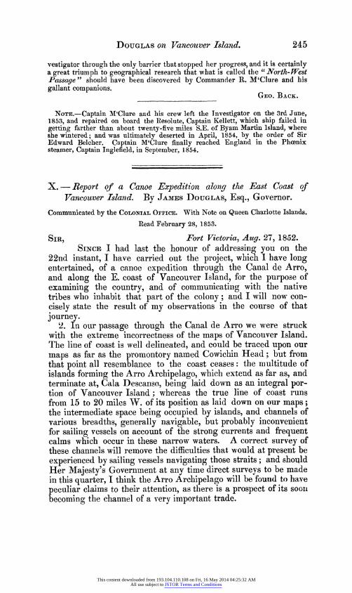
2. In our passage through the Canal de Arro we were struck with the extreme incorrectness of the maps of Vancouver Island. The line of coast is well delineated, and could be traced upon our maps as far as the promontory named Cowichin Head; but from that point all resemblance to the coast ceases: the multitude of islands forming the Arro Archipelago, which extend as far as, and terminate at, Cala Descanso, being laid down as an integral por- tion of Vancouver Island; whereas the true line of coast runs from 15 to 20 miles W. of its position as laid down on our maps; the intermediate space being occupied by islands, and channels of various breadths, generally navigable, but probably inconvenient for sailing vessels on account of the strong currents and frequent calms which occur in these narrow waters. A correct survey of these channels will remove the difficulties that would at present be experienced by sailing vessels navigating those straits; and should Her Majesty's Government at any time direct surveys to be made in this quarter, I think the Arro Archipelago will be found to have peculiar claims to their attention, as there is a prospect of its soon becoming the channel of a very important trade.
This content downloaded from 193.104.110.108 on Fri, 16 May 2014 04:25:32 AMAll use subject to JSTOR Terms and Conditions

246 DOUGLAS on Vancouver Island.
3. On our route through the Canal de Arro we touched at the Cowichin river, which falls into that canal about 20 miles N. of Cowichin Head, and derives its name from the tribe of Indians which inhabits the neighbouring country. They live in several villages, each having a distinct chief, or headman, who cannot be said to rule the community which acknowledges his supremacy, as there is no code of laws, nor do the chiefs possess the power or means of maintaining a regular government; but their personal influence is nevertheless very great with their followers. The Cowichins are a warlike people, mustering about 500 fighting-men, among a population of about 2100 souls.
They were extremely friendly and hospitable to our party, and gave us much information of the interior, which, by their report, appears to be well watered and abounding in extensive tracts of arable land.
The Cowichin rises in a lake, within a few hours' journey of the salt-water arm of Nitinat (Barclay Sound), on the W. coast of Vancouver Island, and is navigable for canoes to its source. These Indians partially cultivate the alluvial islands near the mouth of the river, where we saw many large and well-kept fields of potatoes in a very flourishing state, and a number of fine cucumbers, which had been raised in the open air without any particular care.
4. About 10 miles N. of the Cowichin the Chemanis river enters the Canal de Arro. It is altogether a smaller stream than the former, and is navigable but a short distance from the coast. It is inhabited by a branch of the Cowichin tribe, whom we did not see.
5. As we proceeded N. from the Cowichin a complete change was observed in the physical character of the country, the primi- tive and transition rocks of the Victoria District being replaced by the sandstone formations; in some places falling with a gentle slope, in others presenting precipitous cliffs towards the sea.
6. The promontory of Cala Descanso is the northern point of the Arro Archipelago; beyond which is the Inlet of Wentuhuysen, to which point my attention was particularly attracted through a report of coal having been seen by the Indians in that vicinity. These people are called Nanainio, and speak nearly the same lan- guage, but have not the reputation of being either so numerous or warlike as the Cowichin tribe.
We entered into immediate communication, and found them very friendly, and disposed to give every information we desired in regard to all matters concerning their own affairs and the coun- try which they inhabit.
They live chiefly by fishing, and also grow large quantities of potatoes in fields which they have brought into cultivation earn
This content downloaded from 193.104.110.108 on Fri, 16 May 2014 04:25:32 AMAll use subject to JSTOR Terms and Conditions

DOUGLAS on Vancouver Island. 247
their villages. These are built chiefly on a river named Nanaimo, which falls into the inlet, and is navigable for canoes to the dis- tance of 40 miles from the sea-coast. Food is cheap and abun- dant, and we were plentifully supplied with fresh salmon and ex- cellent potatoes during our stay there.
7. The reports concerning the existence of coal in that place were, I rejoice to say, not unfounded; as the Indians pointed out three beds cropping out in dififerent parts of the inlet; and they also reported that several other beds occurred on the coast and in the interior of the country, which we did not see. One of those beds measured 571 inches in depth, of clean coal; and it was impossi- ble to repress a feeling of exultation in beholding so huge a mass of mineral wealth, so singularly brought to light by the hand of nature, as if for the purpose of inviting human enterprise, at a time when coal is a great desideratum in the Pacific ;* and the discovery can hardly fail to be of signal advantage to the colony. The two other seams which we examined were about I of a mile distant from the former, and measured respectively 3 inches and 20 inches in depth, and are valuable chiefly as indicating the direction of the beds.
There is every reason to believe, from the appearance of the country and its geological phenomena, that Vancouver Island, about Wentuhuysen Inlet, is one vast coal-field: and, if that con- jecture be correct, the progress of the colony will be rapid and prosperous, notwithstanding the many adverse circumstances which have hitherto retarded the development of its resources.
8. That consideration induces me to offer a few remarks on the navigation of the coast between Victoria and Wentuhuysen Inlet. The shortest and most direct route between those points is through the Canal de Arro, a part of the coast of which little is known, and, judging from the maps in my possession, has never been correctly surveyed. Merchant vessels are therefore deterred from taking that route, and follow the circuitous channel explored by Vancouver in the year 1795, which greatly prolongs the voyage, making the difference of nearly a week, in point of time, on a short run of 140 miles.
It is therefore of the very greatest importance to the trade of this colony that the Canal de Arro should be explored and a cor- rect survey prepared as soon as possible, showing the soundings, shoals, and anchorages where ships may bring-to in calms, or during the continuance of adverse winds; and I beg most earnestly to recommend that measure to your consideration, especially as Her Majesty's Government would thereby render an essential service not only to this colony, but to the general interests of trade and navigation.
* Coal has been quoted at San Francisco at seventeen dollars per ton.-ED.
This content downloaded from 193.104.110.108 on Fri, 16 May 2014 04:25:32 AMAll use subject to JSTOR Terms and Conditions

248 DOUGLAS on Vancouver Island.
9. Our excursion did not extend beyond the Inlet of Wentu- huysen, from whence we commenced our return to Victoria, after distributing small presents to the chiefs of the various tribes, with which they appeared highly satisfied.
10. In the course of that journey we observed traces of iron- stone on several parts of the coast; and we also procured a rich specimen of copper ore, found in a distant part of Vancouver Island, which will be hereafter examined.
The Hudson Bay Company's schooner 'Cadborough' lately visited the coal district in Wentuhuysen Inlet, and succeeded in procuring, with the assistance of Indians, about 50 tons of coal in one day. The harbour is safe and accessible to vessels of any class, and the coal is within two cables' length of the anchorage; so that every circumstance connected with this valuable discovery is suggestive of success.
11. The Hudson Bay Company have also sent a small body of miners to examine the coal beds, and to commence immediate operations there.
12. Her Majesty's ship ' Thetis' arrived at Esquimault on the 22nd instant, direct from Queen Charlotte Islands; and, I be- lieve, Captain Kupar has orders from the Commander-in-chief to remain on the coast till the month of January next, chiefly with the view of guarding the ports of Queen Charlotte Islands. The gold diggings in that quarter have not been productive this season, which has not, however, altered the general opinion entertained as to its wealth in the precious metals-the adventurers ascribing their late want of success simply to the circumstance of the true beds not having been discovered.
Fine specimens of lead and copper ore have also been procured on Queen Charlotte Islands, which, in a commercial view, gives it an additional value.
NOTE.-The discovery of gold in this part of Her Britannic Majesty's domi- nions was made by Captain Rooney, who commanded the schooner ' Susan Sturge,' * belonging to Messrs. Gray and Easterby, merchants at San Fran- cisco, and by whom he was instructed to go up to Queen Charlotte Islands, and explore and see what business could be done with those islands that would be advantageous to the trade of San Francisco; and in the early part of the year 1852 he sailed for these northern islands, and on arrival made several disco- veries-one of which was that, instead of there being (as is laid down on the
charts) one large island, a group of three islands were found. He also disco- vered and named Victoria Island, Elliott Isles, Wansey Isle, and laid down the various places named in the sketch annexed. Having entertained friendly intercourse with the natives, whom he found anxious to trade with him, he returned to San Francisco in the latter part of May, and, beside bringing a variety of matters and things relating to the commerce that might be opened
* This schooner has since been taken and plundered by the natives of these very islands on the 26th of September, 1852.-ED.
This content downloaded from 193.104.110.108 on Fri, 16 May 2014 04:25:32 AMAll use subject to JSTOR Terms and Conditions

125 12 e3
Skcetok to illustrate Cda Desea•nso
Report of a CaLoe Expedition along the
Semose. f"aL...i FAST COAST OF VANCOUWVER ISLAND;
",/ by James
DouglasEsq.
GovY
1854._ ,
... .)
Inleort---. 49 4
(DOUTH IF0OMT IVON:
ARCLAY SOUND NN ChuaaiL (NITIEAT)
~ tom
COn ICow'R S
ot Fo r
English Miles VICTO •" b0 "- pez'
CF oser i wsleeahi. ? sy
So e011
;Z54124 o e o C, e e 1r3
Eihs.Mie VsI(2 'sh~~bi~ 50I CT , 1 A
This content downloaded from 193.104.110.108 on Fri, 16 May 2014 04:25:32 AMAll use subject to JSTOR Terms and Conditions

Proceedings of the Party sent to cross the Isthmus of Darien. 249
with these islands, he had on board two sons of native chiefs, who came with him as a guarantee of good faith to parties wishing to trade with them. A spe- cimen of the gold-bearing quartz from Una Point, Mitchell Harbour, in the middle island of the Queen Charlotte Islands, was also brought, which, from an assay made in London, yielded 6317 dwts. 4 grs. of gold to the ton of quartz. Small pieces of gold, varying in size from a grain of wheat to a pigeon's egg, fall out of the rock after blasting. Traces of silver have also been found in the rock.-En.
XI.-Official Report of the Proceedings of the Exploring Party under Commander J. C. PREVOST, of H.M.S. Virago, sent to cross the Isthmus of Darien.
Communicated through SIR RODERICK I. MURCHISON.
Read April 24, 1854.
December 16th, 1853.-(Full Moon.) 8.0 P.M. Weighed and steamed from the anchorage of Taboga, near Panama, shaping a course to pass inside the Pearl Islands. 11. Sighted Pacheca, the northernmost of the Pearl Islands. Daylight, off the Farallon Ingles.
Saturday, 17th.-8 A.M. Entered the Gulf of San Miguel, steering mid- channel between Points Brava and Garachind to avoid the Buey Shoal, which extends some distance S. of the former. The tide or current was strong against us; general soundings from 6 to 8 fathoms, which deepened as we approached Punta Patino. Passed through the Boca-Chica Passage at low- water spring-tides; lowest cast 7 fathoms. Entered the harbour of Darien, a magnificent sheet of water, and at 2.30 P.M. anchored in the mouth of the Savana River.
Sunday, 18th.-8.15 A.M. Discovered the ship dragging her anchor, let go small bower and got steam up; brought up outside the river in Darien Harbour with 48 fathoxns on each anchor. 10.30. Low water. Weighed and pro- ceeded up the river. In picking up a berth, the ship grounded on a soft mud- bank off the right side of the river Savana; laid out kedge, let go small bower, and waited for the tide to flow. 3 P.M. Ship floated, steamed to an anchorage in mid-channel, and moored with swivel, 36 fathoms on each anchor. We were shortly afterwards visited by the authorities from Chapigana, a village situated about 8 miles distant on the S. bank of the Tuyra, containing about 150 inhabitants. These persons, viz. the Gefe Politico and Governor of the province, Don Manuel Borbina, the Alcalde, and Messrs. Hossack and Nelson, Scotchmen, gave us every information in their power of the route we were about to take, and obtained for us all the native assistance we required.
Monday, 19th.-About noon a party in the cutter and gig, with a canoe for the Indians, left the ship fully armed and equipped, with 14 days' provisions.
The latitude and longitude of two principal points being given, viz., Fuerte del Principe, lat. 8' 34' N.,* long. 770 56' W., and Port Escoces, lat. 8' 50' N., long 77' 41' W., I deemed it better to work out our route as a course and distance, and cut our road accordingly, rather than trust to the uncertainty of the published maps, which appear to differ mate- rially from each other. The survey made by Mr. W. Haydon, acting
* The positions of these places are, according to Mr. Gisborne's recent survey (as laid down in his MS. map), also adopted in an Admiralty Chart, just published, Fuerte del Principe, lat. 80 44' N., long. 780 8' W., and Port Escoces, lat. 80 51' N., long. 770 36gI W.-ED.
This content downloaded from 193.104.110.108 on Fri, 16 May 2014 04:25:32 AMAll use subject to JSTOR Terms and Conditions