Embed Size (px)
Citation preview
REPORT FOR STRATEGIC PLANNING COMMITTEE
Date of Meeting 15th July 2015
Application Number 14/04756/FUL
Site Address Land At Salisbury Retail Park
London Road
Bishopdown
Salisbury
Wiltshire
SP1 3YX
Proposal Site 1 - Full application for Class A1 foodstore with associated petrol filling station and car parking, access and landscape works.
Site 2 - Outline application (all matters but access reserved) for provision of public open space/play area (Class D2), incorporating a pedestrian and cycle link between Green Lane and London Road
Applicant Asda Stores Ltd
Town/Parish Council LAVERSTOCK
Ward ST MARKS AND BISHOPDOWN
Grid Ref 415858 131860
Type of application Hybrid Full and Outline Planning
Case Officer Richard Hughes
Reason for the application being considered by Committee
Furthermore, on 11th February 2015, Members of the Strategic Planning Committee approved an application for a food retail store, car park and vehicular access at London Road, Salisbury (ref 14/5997/ful refers). This application, together with the application subject of this current report has been considered together as part of officers assessment of the retail and highways impact of the proposals. Consequently, given the likely combined impact of the retail schemes, it is considered that the matters need to be considered by Committee.
1. Purpose of Report
To consider the above application and the recommendation of the Area Development Manager that planning permission should be APPROVED subject to conditions and a suitable S106 legal agreement.
2. Report Summary
Members are invited to consider the impact of the proposed foodstore on the vitality and viability of the city centre and future investment, the scale and design of the development, visual and landscape impacts, the impact of car parking and traffic, and the strategic road network. The impact of the proposed planned retail store in comparison with two other current superstore applications, including the recently approved ALDI scheme, are also examined in the report.
City Council – Supports the application in principle, but object due to various highway issues remaining unresolved, including the provision of an access from Green Lane, the provision of a 30 mph speed limit along the A30, adequate safe cycle access to the store, and the traffic survey taking into account the new school at the Barratts development.
Laverstock and Ford Parish Council Support, subject to conditions related to noise and antisocial behaviour, and store opening not permitted outside the hours of 7am to 11pm.
Winterbourne Parish Council – Concerned about the likely increase in traffic congestion and possible detrimental impact on the local shop in the Parish
Third parties - 105 letters raising various concerns and issues, including supporting and negative comments regards the impact of the development.
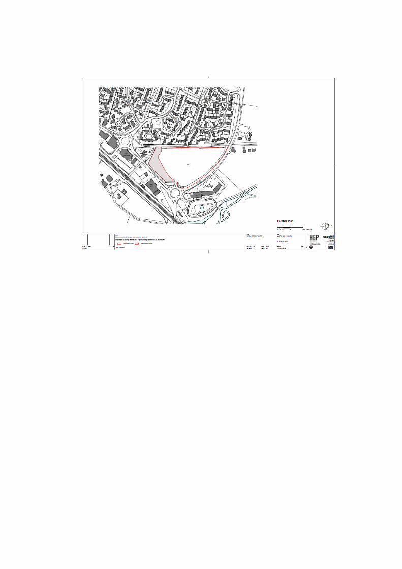
3. Site Description
The application site lies on the north eastern edge of Salisbury in the Bishopdown area of the city, adjacent to Pearce Way and the A30 London Road. It extends to 3.9ha, of which3.4ha comprises the full application area and 0.5ha the outline application. The land is of an open, overgrown character.
Vehicular access into the site is proposed from the roundabout at the junction of the A30 andPearce Way, at which point some limited development has already taken place, beingpreliminary ground works associated with an access that was intended to serve a previouslyapproved retail park in the 1990’s.
The site is bounded to the west by Green Lane, a right of way that separates itfrom residential properties to the west on the Bishopdown Farm estate. To the northeast on the other side of Pearce Way is a Premier Inn hotel and the Hampton Inn pub-restaurant, while to the southeast running down London Road are a number of car dealerships. Further south along London Road are additional commercial premises, including a health & fitness centre and a residential car home, and a petrol filling station containing a small M&S Simply Food, as well as a Park & Ride facility that is accessed off the St Thomas Way/London Road roundabout just south of the site. To the southwest the site abuts the rear gardens of Bishopdown Cottages, a small terrace of houses. Land to the north of Pearce Way is allocated for new housing within the adopted Core Strategy and is currently being developed (Hampton Park).
4. Planning History
The site in question and the immediate surrounding area has a long, detailed, and complex planning history. However, in relation to the site subject of this application, the following previous applications are considered to be of most relevance:
S/2012/0905 Material amendment application - to alter internal layout of retail units approved as part of planning permission S/2011/1723.
S/2011/1723 Application to vary Condition 1 of extant planning permission S/2007/1460 (8 unit retail warehouse development providing 8,361m2 of retail floorspace on the ground floor with 4,182m2 of retail floorspace at mezzanine level, together with associated car parking, cycle parking, servicing, access and landscaping) to extend time limit for implementation.
S/2007/1460 8 unit retail warehouse development providing 8,361m2 of retail floorspace on the ground floor with 4,182m2 of retail floorspace at mezzanine level, together with associated car parking, cycle parking, servicing, access and landscaping
S/2002/2117 erection of a mixed use development comprising a 4812 metres squared gross (2787 m squared net) foodstore (class a1) with coffee shop separate colleague & customer car parks service yard & vehicular & pedestrian access together with 1254m squared gross (930m squared net) of office accommodation (b1) & a 890m squared retail parade (a1) & associated landscaping
S/1998/0373 Reserved matters approval associated with outline consent S/1994/0632 Approved 1998. (Note: Members should note that following this approval and the discharge of conditions, works commenced on site, thus keeping the permission alive in perpetuity)
S/1994/0632 Outline planning permission for a bulky goods retail units (8361sqm) and a garden centre, together with cap parking, and access off London Road. Approved, subject to a legal agreement related to various highway measures. (Members should note that a bulky goods retail condition was imposed).
S/1991/1664 Outline application - construction of a motor traders park together with the construction of a new roundabout and the realignment of the A30 london road (Note: Members should note that whilst the motor traders park was never developed, the new roundabout and associated highway works were commenced, leading to the road arrangement at the site today).
Notwithstanding the above planning history related to the specific site, Members should also be aware that the impact of this application needs to be considered in combination with other
major applications for retail and other uses in the area, of which the following are considered of most relevant:
14/03690/FUL – Food retail store, petrol station, parking, roadworks, and wetland Southampton Road, Salisbury (currently undetermined)
14/05997/ful – ALDI food retail store, London Road, Salisbury. Approved subject to a S106 agreement
S/2009/1943 – Hampton Park 2 – Full planning permission allowed on appeal for 500 dwellings, vehicular access onto Pearce Way, and a Country Park.
And also the following developments which affect the A36 trunk road system:
15/1104/ful – Dolphin Industrial Park, Southampton Road, Salisbury. Variation to bulky goods retail conditions in relation to consent S/2012/1808 (not yet determined).
14/12175/FUL 65 bed hotel with drive thru restaurant with associated parking, access and landscaping. (Currently undetermined)
14/11461/ful Access (egress) serving Tesco’s, off Petersfinger Road. (Currently undertermined).
14/10789/VAR - Countrywide stores, Hatches Lane Salisbury – Relaxation of retail planning conditions. Approved.
14/03278/VAR - Dunelm, Hatches Lane, Southampton Road, Salisbury. Relaxation of retail planning conditions. Approved. (Store now trading).
S/2012/1808 – Dolphin Industrial Park, Southampton Road, Salisbury (see above)
S/2010/1274 - Tesco, London Road, Amesbury
S/2008/0550 – Lidl, Southampton Road, Salisbury
5. The Proposal
The proposal has been adjusted and amended following the various consultation comments submitted over recent months, and can be divided into two parts:
Site 1 - Full application for Class A1 foodstore (amended scheme) with associated petrol filling station and car parking, access and landscape works. The store would have 4,937sq m gross floorspace (2,323sq m net); and a reduction in car parking spaces from 361 to 274 spaces in line with the reduced sales.
Site 2 - Outline application (all matters but access reserved) on 5083sq m site, for provision of ecological mitigation, as well as public open space, incorporating a pedestrian and cycle link between Green Lane and London Road
Furthermore, as a result of comments from the various highways consultees and other parties, the applicant has also submitted an “alternative” layout plan for the site which shows
how a pedestrian and cycle link could be provided between the retail store and the adjacent Green Lane (this matter is covered in detail in the following report).
The application did not require an Environmental Impact Assessment, but has been submitted together with a variety of reports, including:
Retail assessment Design and access statement Landscape proposals design report Tree reports Statement of community consultation Transport Assessment and Travel Plan Energy and sustainability reports Ecology and lighting reports Noise and Air Quality
(Members should note that the detailed elevations and other plans related to this scheme also show the likely location and appearance of several advertisements associated with the retail store. Please note that such adverts will require a separate advertisement consent application in due course, and cannot be determined through this current planning application).
6.Planning Policy
NPPF– Given the scale of this application, much of this guidance is relevant to this application. The most relevant sections and policies are referred to throughout the following report.
NPPG – Overall design, environmental impacts, and general impact on amenities
Wiltshire Core Strategy - The most relevant policies of this document are as follows:
CP 21 – Maltings and central car parkCP41 – Sustainable constructionCP36 – Economic regenerationCP38 – Retail and leisureCP50-52 –Landscape infrastructure and ecologyCP57 – Design and amenityCP58 – Conservation of the historic environmentCP61 - Transport and DevelopmentCP67 – Flood RiskCP69 – River Avon SAC
6. Summary of consultation responses
WC Highways – No objections subject to a number of S106 contributions and suitable conditions (see highways section of Planning Considerations section for more details)
WC Rights of Way – Would like to see a pedestrian and cycle link with Green Lane as per the applicants alternative suggested plan in order to encourage users of the store who may live nearby the walk and cycle to the store.
WC Transportation team – Welcome in principal the proposed cycle and footpath link on the planned open space but concern that the pathway would not be sufficiently linked into the adjacent planned store to encourage more sustainable access to the site. Also, would welcome the creation of a pedestrian and cycle link between the store site and Green lane. Also, raised issues regards the number more motorcycling bays be provided and that a shelter for mobility scooters should also be provided.WC Archaeology – No objections subject to a watching brief being conditioned.WC Drainage – Comments made regarding about the methods and consents required subject to drainage proposals.WC Public Art – Provision of public art required in line with Council policy and strategyWC Ecology – Compensatory ecological mitigation is required due to the removal of the existing open land. This could be provided in the planned open space and the landscaping, particularly along Green Lane – this will need to be secured in any S106. Condition requiring a Construction Environmental Management Plan to control the impact on the SAC river system, and a Landscape and Ecology Management Plan to ensure protection of on site protected species.WC Landscape- No wider landscape issuesWC Urban Design – Raised issue related to the design and materials of the building and whether the building would be sympathetic to the areaWC Open Space – Preferred option is for ASDA to maintain the open space in perpetuity rather than this Council.WC Conservation – There are no known heritage assets that would be affected by the proposal therefore, no comments to make.WC Public Protection – Following discussions, agreed the imposition of a condition related to a noise assessment strategy, and a request for contributions towards improving air quality/sustainable transport initiatives. WC Spatial Planning - The retail priority for the council at Salisbury the proposed redevelopment of the Maltings and Central Car Park, this is a town centre site adjacent to the existing Primary and Secondary shopping areas and this development together with the existing convenience commitments in South Wiltshire and Salisbury will meet the convenience and comparison need up to 2021, hence the reason why the WCS does not allocate a site for a further supermarket.
The proposal is therefore not in the up to date development plan as evidence does not indicate that a further convenience store is needed in Salisbury. As the NPPF forms a material consideration a retail appraisal has been undertaken by the applicant in order to assess whether the proposal meets the sequential test and impact requirements of CP 38 of the WCS and the NPPF or not and whether if it meets the requirements and represents a retail material consideration to indicate that the proposal can be approved. The Council has in response commissioned consultants to assess the applicants retail appraisal and this concludes that for the reduced scheme this proposal meets the sequential test and impact would be more limited and therefore can meet the requirements of the NPPF.
As the NPPF forms a material consideration, the retail appraisal that is being undertaken separately, will determine if a retail material consideration indicates that this proposal is appropriate in respect to retail policy. This has now shown that the proposal can be considered for approval.
Responses from other council and statutory consultees should be considered and recommended conditions attached to any approval.
Environment Agency – No objection subject to conditions related to surface water drainage and a construction environmental management plan.Natural England – No objections subject to suitable conditions related to sustainable surface water drainage being providedEsso – No objections provided the pipeline is protected during developmentEnglish Heritage – No commentsHighways Agency – Direction of Non Approval Withdrawn. It is considered that the proposal would not adversely affect the strategic road network, and would reduce traffic along the A36 Southampton Road artery.Network Rail – No observations to makeWiltshire Fire and Rescue – General safety adviceWessex Water – Existing foul sewer runs across the same part of the site as the esso pipeline, and this must be protected. There is adequate capacity within existing water supply.
7. Publicity
Bishopdown Farm Residents Association – provide the following comments:
i) London Road – concern about the impact on vehicular traffic on this extremely congested road, and consideration should be given to reducing the speed limit to 30mph from St Marks Roundabout to St Thomas Bridge.
ii) Opening delivery hours – should reflect proximity to residential areasiii) Green Lane access – Would welcome such an access as it would encourage
residents to walk to the storeiv) Signage – should be kept to a minimum. Do not like the suggested rooftop sign which
would be highly visible and intrusive.v) Trolleys- The scheme should be designed to stop these being taken off sitevi) Bus Stops – The bus service expansion should include capacity for ASDA shoppersvii) Litter – Bins in suitable locations are needed
Salisbury City Council – Supports the application in principle, but maintains an objection until a pedestrian and cycle route being provided between the store and Green Lane at the junction with Linford Road. Lighting needs to be installed on the southern end of Green Lane. Access to public transport needs further work to ensure that passengers can safely and easily access bus services on the eastern side of the A30. The speed limit on the A30 must be reduced to 30mph out to the A338 roundabout to provide safer access and egress at the ASDA entrance and improve general safety for cyclist, pedestrian and motorists along the London Road.
Laverstock and Ford Parish Council Support, subject to conditions related to the following:
i)Noise within the delivery area must be minimal and be contained by fencing and shielding ii)The times of delivery to the store must be controlled to avoid a nuisance to neighbouring properties
iii)Store opening must not be permitted outside of the hours of 7am to 11pmiv) There must be robust security in order to prevent anti-social behaviour in the car park when the store is closed
Winterbourne Parish Council – Concerned about the likely increase in traffic congestion and possible detrimental impact on the local shop in the Parish
Third party comments - 105 letters raising the following matters:
Proposal would exacerbate traffic problems along London Road Would result in traffic parking in adjacent housing area Too much traffic and development in area, including 500 new dwellings Would adversely affect city centre retail trade and local shops More supermarkets not needed Supermarket needed to west of city centre, not here Would adversely affect Laverstock which will be used as a rat run Loss of valuable open space and ecological land/protected species May adversely impact the amenities of adjacent housing due to noise and
disturbance, light pollution Antisocial behaviour may result in adjacent housing area Welcome ASDA store, will reduce trips to other ASDA stores (inc Andover) Reduce traffic along Southampton Road Reduce traffic along London Road to Andover
Cycling Opportunities Group (COGS) – A number of reservations regarding out of town development and its effect on local transport infrastructure, but in this case, the adverse effects of trip generation by the supermarket may be balanced by a reduction in trips generated further afield to existing supermarkets that are remote from residential areas. The application includes a number of improvements to cycle and footways, but the previously proposed access to Green Lane needs to be restored for adjacent residents. We object unless this access is reinstated.
Milford Preservation Group - The application continues to have great merit, in that a) creation of a major retail outlet in the growing residential area to the Northeast of Salisbury is an essential element in the City's future; b) it would lead to a reduction of traffic passing through Laverstock village , Milford and the 'rat run' Milford Mill Road leading to the Bourne Retail Park off the A36 Southampton Road; and c) it would relieve the ever-increasing traffic congestion on the A36 Southampton Road between Alderbury and the Salisbury College Roundabout. For these reasons we give our full support to the revised Application.
8. Planning Considerations
8.1 Principle of development and planning policy
The National Planning Policy Framework (NPPF) indicates clearly that:
“14. At the heart of the National Planning Policy Framework is a presumption in
favour of sustainable development, which should be seen as a goldenthread running through both plan-making and decision-taking.
For decision-taking this means:
●approving development proposals that accord with the development planwithout delay; and●where the development plan is absent, silent or relevant policies areout‑of‑date, granting permission unless:
–– any adverse impacts of doing so would significantly and demonstrablyoutweigh the benefits, when assessed against the policies in thisFramework taken as a whole; or–– specific policies in this Framework indicate development should berestricted.”
At paragraph 111, the NPPF also indicates that:
“111. Planning policies and decisions should encourage the effective use of land byre-using land that has been previously developed (brownfield land), providedthat it is not of high environmental value. Local planning authorities maycontinue to consider the case for setting a locally appropriate target for theuse of brownfield land.”
Core Policy 36 (Economic Regeneration) of the Wiltshire Core Strategy supports regeneration opportunities and aims to maximise the re-use of previously developed land. The provision of economic development on previously developed land will therefore be supported. The policy indicates that:
“Regeneration of brownfield sites will be supported in the Principal Settlements, Market Towns and Local Service Centres where the proposed uses help to deliver the overall strategy for that settlement, as identified in Core Policy 1 (Settlement Strategy) and in any future community-led plans, including Neighbourhood Plans, and/or enhance the vitality and viability of the town centre by introducing a range of active uses that complement the existing town centre.”
The “fall back” position
The site subject of this application has an extant planning permission for a bulky goods retailing scheme, which was approved in the mid 1990’s and a start was made on the scheme, (the creation of an access arrangement off London Road) thus keeping the permission alive in law (Reserved matters 1998/0373 refers), and in theory, enables that particular development to be continued at any time, although given how much time has elapsed since the consent was given and works started, it seems unlikely that such a historic proposal would now actually be built out in reality. The footprint of the building permitted was just above 8000sqm, plus 420 car parking spaces.
The land was subsequently allocated for development in the 2003 Salisbury District Local Plan, and planning permission was later given on appeal for a similar bulky goods retail scheme in 2009 (application ref S/2007/1460 refers). This permission was subsequently renewed by later applications for modifications to the scheme until April 2015. Whilst (to the
best of officers knowledge), this later approval has not been commenced and hence may well have lapsed, a future revised application was a similar scheme would be difficult to resist in planning terms. The permitted footprint was just over 8000sqm with 405 parking spaces. With mezzanine floors, the floor area permitted was just over 12,000sqm gross.
Consequently, whilst the site is no longer subject of an policy allocation under the newly adopted WCS, officers consider the site to effectively fall within the definition of brownfield, previously developed land, due to the extant planning permission on the site from the 1990’s.
As a result, the principle of the development of the land would be difficult to refute, and its development for some form of retail use is considered to be acceptable, subject to its impacts. Such impacts are considered elsewhere in this report.
Other retail applications and developments
This impacts of this current retail application (for ASDA), needs to be assessed in the context of at least two current applications for retail development (see planning history section of this report for more details). Firstly, a separate application for an ALDI store has been approved only a few hundred metres south of the ASDA site, on the eastern side of London Road, adjacent to the existing park and ride site (application 14/05997/ful refers). Members of Strategic Committee resolved to approve the ALDI scheme, subject to a suitable S106 and conditions.
The cumulative impact of this store and the ASDA store in retail terms on the city centre retailing strategy needs to be considered, as does the joint impact of both on traffic congestion along London Road and the surrounding highway network.
Similarly, an application by for a retail store on Southampton Road in Salisbury has also been submitted (application 14/03690/FUL refers). The cumulative impacts of this scheme, together with the ALDI and ASDA schemes on the city centre retail environment and the highway system also needs to be considered.
The following report considers these cumulative impacts, as well as those resulting from recently consented retail schemes in the immediate area of the sites concerned.
Hampton Park development
This is of relevance to this report as the planning application related to 500 dwellings has recently been approved and is partially completed, on land to north of the application site. The Secretary of state approved the scheme in September 2011. As part of the consideration of this current retail application, the 2009 appeal decision approving the retail park was taken into consideration. In particular, the transport assessment and EIA took into account the approved/extant retail approval on this site and its impacts. As a result, it is considered that the cumulative impacts of both schemes would have been fully considered by the Inspector. The housing is now being built out. As a result, the impacts of this significant development have been considered in conjunction with this retail application, particularly with respect to highway impacts.
8.2 Retail impact on city centre and Maltings/Central Car Park scheme
A number of the third parties have raised concerns about the impact of the ASDA store on the vitality and viability of the city centre. However, a number of responses have also welcomed the proposal. Others have highlighted the need for a retail store to the west of the city, not on this site. These responses are summarised elsewhere in this report.
As a result of the 2009 appeal case related to this London Road site (S/2007/1460 refers), the development of the land for a large scale bulky goods retail scheme has considered to be acceptable in recent years. Further, given the extant planning permission on the site for a similar bulky goods scheme, this currently scheme subject of this application (by ASDA) needs to considered against this planning history background, plus any policy changes and other material considerations. In particular, the ASDA proposal has been considered in the context of the recent approval of an ALDI store, also on London Road, and the currently undetermined application for a retail store on the Southampton Road, Salisbury (which itself is affected by other recent and current applications related to retail matters along the A36, as listed in the Planning History section of this report).
In terms of National Policy, the previous appeal decision in 2009 was made against the backdrop of PPS4, which has since been replaced by the NPPF. This continues the town centre first stance of the previous guidance, and indicates the following:
“23. Planning policies should be positive, promote competitive town centreenvironments and set out policies for the management and growth ofcentres over the plan period..”
Paragraph 24 of the NPPF continues thus:
“24. Local planning authorities should apply a sequential test to planningapplications for main town centre uses that are not in an existing centre andare not in accordance with an up-to-date Local Plan. They should requireapplications for main town centre uses to be located in town centres, then inedge of centre locations and only if suitable sites are not available should outof centre sites be considered. When considering edge of centre and out ofcentre proposals, preference should be given to accessible sites that are wellconnected to the town centre. Applicants and local planning authoritiesshould demonstrate flexibility on issues such as format and scale.”
Paragraph 26 & 27 of the NPPF continues thus:
“26. When assessing applications for retail, leisure and office development outsideof town centres, which are not in accordance with an up-to-date Local Plan,local planning authorities should require an impact assessment if thedevelopment is over a proportionate, locally set floorspace threshold (if thereis no locally set threshold, the default threshold is 2,500 sq m).This shouldinclude assessment of:
● the impact of the proposal on existing, committed and planned public andprivate investment in a centre or centres in the catchment area of theproposal; and
●the impact of the proposal on town centre vitality and viability, includinglocal consumer choice and trade in the town centre and wider area, up tofive years from the time the application is made. For major schemes wherethe full impact will not be realised in five years, the impact should also beassessed up to ten years from the time the application is made.
27. Where an application fails to satisfy the sequential test or is likely to havesignificant adverse impact on one or more of the above factors, it should berefused.”
Since the 2009 appeal decision related to this site, the previous Salisbury District Local Plan and the South Wiltshire Core Strategy have now been replaced by the Wiltshire Core Strategy. Policy 38 of the WCS and its supporting text seeks to enhance the vitality and viability of the town centres in Wiltshire through policies promoting the regeneration of central areas and delivery of new growth at settlements to support the vitality of centres. The policy states that:
“All proposals for retail or leisure uses on sites not within a town centre in excess of 200 sq metres gross floorspace, including extension of existing units, must be accompanied by an impact assessment which meets the requirement of national guidance and established best practice, and demonstrates that the proposal will not harm the vitality or viability of any nearby centres. All such proposals must also comply with the sequential approach, as set out in national guidance, to ensure that development is on the most central site available.”
More specifically, the WCS also contains reference to the redevelopment of the Maltings and Central Car Park Site within Salisbury City Centre, in policy CP21. The WCS indicates that the strategy promotes the sensitive regeneration of a mixed-use retail led development on the Maltings and Central Car Park. Not only is the site sequentially preferable, but it also offers an excellent opportunity large enough to deliver the level of retail development needed for the city within a central location. Its proximity to the existing city centre means it can complement the existing centre rather than compete with it. This will help contribute towards the continued viability and vibrancy of the whole of Salisbury City centre and should incorporate an element of residential, office and leisure uses.
The impact of any development of the London Road site on this proposed development of the Maltings and central car park (which is an allocated site within the WCS) was a significant material consideration as part of the 2009 appeal considerations. Since that time, the situation regarding the Maltings and Central Car park site has continued to mature, with ongoing discussions between the owners of the site and the Council. A draft master plan has been drawn up, which was the subject of public consultation in 2013. As a result, the issue remains of significant material weight, as it was in 2009.
A detailed retail study has been submitted with the application, which assesses the likely impacts of the scheme, including the impact of the scheme in conjunction with other consented retail schemes. The applicants retail report offers the following conclusions:
• The application site already benefits from an extant planning permission for major non-foodretail development. The current planning application will therefore result in a significant reduction in the quantum of Class A1 retail floorspace.
• Compared to the fallback planning permission, the proposed Asda will also provide over0.5ha of land for community use, with the hybrid application seeking outline permission for
a variety of possible uses.
• Currently main food shopping in Salisbury is dominated by the Tesco Extra store onSouthampton Road, and to a lesser extent the Waitrose on Churchill Way West. Bothstores (together with the Sainsbury in the city centre) are trading well above theirbenchmark company average levels. This is suggestive of a quantitative need for anotherstore. The proposed Asda would address this while also providing increased choice andcompetition to local residents.
• The location of main foodstores across Salisbury shows a gap in provision in the northernpart of the city. As well as the extensive areas of existing housing this part of the city alsocontains major allocations for further residential development, increasing the need for anew store to serve this area.
• Owing to the historic nature of the city, the only site within the city centre that would becapable of accommodating a new superstore is The Maltings/Central Car Park. Howeverthat is integral to the Council’s strategy of improving the city centre’s non-food retail offer,which is required to strengthen the city against competition from other centres. The onlyfood retailing envisaged for this site is a relocation/enhancement of the existing Sainsburysupermarket. The development of another superstore would not be suitable.
• The proposed ASDA will not cause any significant adverse impact on the vitality or viabilityof any defined centre, and will not prejudice the Council’s aspirations for theMaltings/Central Car Park redevelopment.
• The proposed store will provide up to 350 new jobs within the store, as well as further job opportunities during the construction phase.
• In diverting trade away from the existing Tesco Extra store the proposed Asda will alsomake a small contribution to reducing the existing traffic congestion along SouthamptonRoad. It is also known that some residents in Salisbury are currently travelling out of thecity to visiting the existing Asda stores in Andover and Totton: the provision of a store onLondon Road will therefore reduce the need to travel.
The Council commissioned an assessment of the applicants retail report, undertaken by GVA Grimley. This report initially concluded that applicants retail report had a number of flaws, namely:
The applicant’s supporting material lacked a proper assessment ofthe non-food and leisure elements against the tests of impact and the sequentialapproach.
Inadequate information and analysis to demonstrate compliance with the sequential approach to site selection. In particular, the applicant has not demonstrated sufficient flexibility in terms of scale and format when considering alternative sites and there is the lack of a proper assessment of the suitability and availability of the MCCP site.
The ASDA store is likely to have a significant impact upon the health of Salisbury city centre and the Maltings site, by virtue of the direct convenience and comparison goods impacts and the potential of the store to affect vitality and viability levels within the centre.
The applicants have responded to the above critique, and have adjusted and reduced the scale of the net sales area of the retail store down to approximately 2,323sqm (from 3,716sqm), and have thus argued a corresponding reduction in the likely retail impact of the proposal on the city centre.
Notwithstanding the applicants amendments and arguments, it has also recently transpired that Sainsbury’s have decided to pull out of its involvement in the ongoing Salisbury Gateway application at Southampton Road, subject of separate undetermined application 14/03690/ful. This has implications for the ASDA proposal, as it may suggest that Sainsbury’s may wish to concentrate its efforts on its city centre store, located on the Maltings/city centre car park site. Consequently, if this is the case, Sainsbury’s ongoing involvement in the Maltings project makes it more unlikely that the central site would be available to ASDA.
The Council’s retail advisers, GVA Grimley, have concluded that the significantly reduced ASDA proposal is now likely to have a more acceptable impact on the city centre than the original scheme (approximately half the original impact), and far less impact than the undetermined Southampton Road application, and has advised that, should the Council be minded to approve this proposal, then conditions are placed upon the approved store to control the amount of convenience and comparison goods floorspace, along with the total net sales area and the ability to sub-divide the unit into separate parts.
Based on the above, Officers advise that the next best sequential preferable site for the ASDA proposal (other than the Maltings site) would appear to be the site subject of the application. This view is based on the assessment of a number of different sites, and the assessments of the various planning merits of the development outlined within this officer report, which suggests that in the main, the proposed development on the London Road site would have impacts which could be mitigated successfully, and is located close to existing housing areas, thus enabling easy access by non-car methods of travel. In contrast, there remains a number of unresolved planning issues with the Southampton Road site and these are likely to remain issues even if the planned ASDA development were to be proposed at the Southampton Road site. Consequently, officers conclude that at the time of writing, the London Road site is a preferable site sequentially.
In retail terms, the proposal is therefore considered acceptable and in line with national and local plan retail policy, subject to a number of restrictive retail conditions, to limit the retail impact of the scheme.
8.3 Impact on highway systems around the site
London Road and hence the site, is accessed via the A36 Trunk road system. Numerous third party objections have been received related to the impact of this proposed development on the highway system around the site, particularly on the already busy London Road route, and the smaller road system in the adjoining residential areas, including through Laverstock. From the 105 pieces of correspondence concerned, it appears to be one of the main areas concern.
The NPPF indicates at paragraph 23 that:
“32. All developments that generate significant amounts of movement should besupported by a Transport Statement or Transport Assessment. Plans anddecisions should take account of whether:
●the opportunities for sustainable transport modes have been taken updepending on the nature and location of the site, to reduce the need formajor transport infrastructure;●safe and suitable access to the site can be achieved for all people; and●improvements can be undertaken within the transport network that costeffectively limit the significant impacts of the development. Developmentshould only be prevented or refused on transport grounds where theresidual cumulative impacts of development are severe.”
At paragraph 75, the NPPF also states that:
“75. Planning policies should protect and enhance public rights of way and access.Local authorities should seek opportunities to provide better facilities forusers, for example by adding links to existing rights of way networksincluding National Trails.”
Core Policy 61 (Transport and New Development) of the WCS indicates that:
“New development should be located and designed to reduce the need to travel particularly by private car, and to encourage the use of sustainable transport alternatives. As part of a required transport assessment, the following must be demonstrated:
i. That consideration has been given to the needs of all transport users (where relevant) according to the following hierarchy:a. Visually impaired and other disabled people b. Pedestrians c. Cyclists. d. Public transport. e. Goods vehicles. f. Powered two-wheelers. g. Private cars.
ii. That the proposal is capable of being served by safe access to the highway network iii. That fit for purpose and safe loading/unloading facilities can be provided where these are required as part of the normal functioning of the development. Where appropriate, contributions will be sought towards sustainable transport improvements and travel plans will be required to encourage the use of sustainable transport alternatives and more sustainable freight movements.”
A detailed Transport Assessment was submitted with the application. This was subsequently amended following comments from the Highways Agency (now Highways England) and incorporates highway data associated with the recent ALDI application scheme further south along London Road. The applicants report concludes the following impacts are likely:
a)Hampton Park Roundabout. The analysis in the ATA showed that this junction will operate within capacity in all three peak hours;
b)St Thomas Way roundabout is approaching capacity in the Friday evening peak hour by 2025 without the proposed development. The analysis has shown that change in traffic flows at this junction as a result of the proposed development will not have an adverse impact on the operation of the roundabout. The roundabout will continue to operate within capacity in the morning peak hour and Saturday peak hour.
c)The Barrington Road/London Road junction is operating within capacity in all time periods with and without the proposed development. By 2025, in the morning and evening peak hour with and without the proposed development the junction is operating at capacity. However, the analysis has shown that change in traffic flows at this junction as a result of the proposed development will not have an adverse impact on the operation of the junction. The junction will continue to operate within capacity in the Saturday peak hour with and without the proposed development.
d)St Mark’s roundabout. The change in traffic flows were calculated and St Mark’s roundabout is proposed to experience a reduction of trips in the base plus development scenario compared to the base scenario and therefore no further assessment is considered to be necessary. This was subsequently agreed with the Highways Agency.
Based on the interpretation of the junction analysis, the applicants report concludes that proposed development will not have an adverse impact on the operation of the local highway network and furthermore, the report considers that mitigation measures are not required.
Based on the above report and discussions with the applicants, and after detailed consideration of the matter over a number of months, the Highways Agency withdrew its Direction of Non – Approval regards the application, thus signalling the Agency’s support for the proposal in terms of the impact of the scheme on the A36 road system, including the St Marks roundabout. As a result, it is considered that it would now be difficult to refuse the application on the basis of the impact of the ASDA application on the A36 trunk road system or its junction with London Road.
With regards the impact of the scheme on London Road itself and the surrounding highway systems within residential areas, the Council’s own highways officer has also critical assessed the scheme, and has made the following comments:
“There is a previous permission on this site for non-food retail units and the site benefits from an extant permission for such a use. In assessing this proposal it is therefore necessary to look only at the increase in traffic over that likely to be generated by the previous, extant, permission.
It is now proposed to have a reduced size of store and a revised Transport Assessment has been submitted. It compares the new proposal with the extant permission and also take account of the new residential development at Hampton Park and the recently approve Aldi store on London Road. I have examined the document and agree with the conclusion that London Road and the local highway network has adequate capacity to accommodate the additional movements generated by the proposed store. It should be borne in mind that the peak traffic generation for food retail does not generally correspond with peak flows on the highway, although some “pass by” trips will occur during those peak periods.
I have examined the latest internal layout and I note that no direct is proposed access from Green Lane. I consider that that link is important to attract non-car trips to the store as it
offers a more direct, and thus shorter, route into the store for cyclists and pedestrians than that through the open space to the west of the site, which will also require users to cross the access to the service yard. A link is clearly feasible as it has been shown on previous layout plans and it should be provided in addition to the link through the open space which links Green Lane with London Road.”
“I note that the application includes additional lengths of footway along the roads adjacent to the site and these will need to be provided prior to the store opening. These footways will be located on the existing highway verge and will thus form part of the adopted highway. A legal agreement will be required to cover their construction.
The bus services along this section of London Road are currently infrequent. This will be changed in the near future when the hourly R7 service is diverted to operate via Pearce Way. Future service frequency improvements (to 2 per hour) are also likely with funding being provided by the Hampton Park development. However, in order to influence the modal split on journeys to the store, I consider that a more frequent and reliable service will need to be provided and thus a contribution is sought for the improvement of bus services along the London Road corridor.
I have examined the S106 Unilateral Undertaking in respect of the previous permission on the site. This contains two main transport provisions namely a public transport contribution of £300,000 and a £500,000 contribution to the improvement of St Thomas bridge should this be undertaken within 10 years, the latter secured by a Bond. I have already identified the need for the Public Transport contribution above and a sum of £350,000 for improvements to the public transport provision on the London Road corridor would be appropriate for this development given the time lapse since the previous permission.
I have looked carefully at the bridge contribution and note that its purpose was to remove the need for higher vehicles to use the centre of the carriageway and thus reduce the likelihood of vehicles hitting the bridge. However I acknowledge that no progress has been made with this scheme since it was identified during the first application on this site over 15 years ago and also that 6 years have passed of the ten years specified in respect of the last permission. Whilst the bridge works have highway benefits they cannot be claimed to be necessitated by the development. For this reason I do not consider that the requirement for a contribution/Bond would meet the current tests in the CIL regulations and thus this element is not being pursued.
There will be a need for a Green Travel Plan for the store and this can be secured either as part of the S106 Agreement or by way of condition. Subject to a S106 Agreement to secure the public transport contribution outlined above there is no highway objection to this application”
As a consequence of the above comments, it is considered that despite the understandable local concerns related to traffic impact, it would be difficult to refuse the proposal on the impact of the proposal on the A36 trunk road system or the London Road A30 or associated road network around the site, provided a suitable S106 agreement is entered into and suitable conditions proposed, which would mitigate the identified highway impacts. The other highway and access related matters are also considered below.
Access to the site via a linkage from Green Lane
As part of the numerous third party and other consultee comments received, many have notably either requested that some form of pedestrian and cycle access is created from Green into the site, or have requested that no such link is created. Given this split in opinion, the developers have simply offered to alternative sets of plans, one showing the provision of such an access, the other no access.
In officers opinion, the provision of a link would be sensible in sustainability terms, creating an easy non –car way of access the site, which may encourage more people from the adjacent housing to leave their cars at home, and shop more sustainably. The Council Sustainable Transport Highways Team support the provision of such a link, as do other consultees, including WC Highways, the City Council, and COGS and BFRA.
However, the negative side to providing such a link is that it may encourage users of the supermarket to park within the adjacent housing area close to the site, and to walk through to the store. This point has been highlighted by a number of residents, as has the possible creation of antisocial behaviour, although limited justification for this is given.
Notwithstanding this matter, the creation of a link wide enough to allow cycling and pedestrians (usually approx 3 metres), is likely to result in some possible harm to existing trees and shrubs along Green Lane, and open up views of the store and its operations to users of Green Lane, thus further increasing the impact of the store on the surrounding area. Any additional lighting of this path in future is also likely to affect adjacent trees and wildlife.
Notwithstanding the above, it would in any case be possible to access the site sustainably, using either the planned cycle and pathway route via the area of planned open space to the south of the store, or via the pathways linking to the extended path around Pearce way to the north of the site, which links into Green Lane and the surrounding highway system.
Consequently, whilst the positive sustainable benefits of a pathway link are understood, it is considered that the likely negative impacts of the provision of such a path in the suggested location may outweigh any positive gains accrued. However, should members consider otherwise, it would be possible to condition the creation of the suggested pathway link as shown on the alternative plans as submitted.
Additional footpaths around the site
Currently, the footpath system around part of the site (north east of the vehicular access to the site adjacent to Pearce Way) is incomplete. The proposal would complete the footpath/cycleway in this area, improving the accessibility of the site. This is considered to be a positive improvement resulting from the proposal.
Site B - Access between Green Lane and London Road
As referred to above, the proposal also provides for a footpath and cycleway on the planned open space adjacent the retail store site and Bishopdown Cottages. In officer’s opinion, this will enhance linkages around the site, and improve upon the current footpath arrangement,
given the narrow nature of part of the London Road pavement adjacent to Bishopdown Cottages. This is considered to be a positive improvement resulting from the proposal. It is noted that some third parties, including the Council’s transportation team, have suggested that the access arrangements as proposed in this location may result in possible conflict between cycle users and vehicles. It is accepted that it may not be a totally ideal arrangement in so far as this route involves cycles crossing the roadway to the service area. However, this is a small proportion of the route, and it is difficult to see how this area could otherwise be arranged to avoid all conflict with vehicular traffic. Subject to adequate sight lines and markings/signage in this location, it is considered that the proposed arrangement would not, in officers opinion, be so likely to result in obvious conflict as to warrant the refusal of the whole scheme solely on this basis. Indeed, it is considered that the benefits of this linkage to Green Lane outweigh the likely harm caused by the perceived safety issue.
Highway works to the A30
The surrounding highway system was remodelled in the early 1990’s as part of the previous historic planning consents for the application site and the adjacent housing developments.
A number of third parties have suggested that this proposal should only be acceptable subject to works to reduce the speed of traffic along the A30. Whilst such concerns are understandable, neither of the previous planning permissions for retail development on this site contained such a requirement, save for a requirement previously to allow future works to lower the road beneath the railway bridge. However, neither the Council’s Highways officer nor the Highways Agency has suggested any such works being necessary to allow this current development. As a consequence, it would be difficult to justify any significant highway adjustments above and beyond those required by the highways consulters.
Sustainable travel
Notwithstanding the above, a significant financial contribution would be generated by this development towards improving the existing bus service in this area. A contribution of some £350,000 has been mooted and this will be secured via any S106. Similarly, a Green Travel plan for the use will help create a modal shift to more sustainable forms of travel for the employees of the store.
Overall, given the recent planning history of the site, and given the comments of the Highways Agency and the Council’s own highways officer, it is considered that a refusal of the scheme on the basis of the likely impacts of the development on the surrounding highway systems would be difficult to justify, and that suitably conditioned, the scheme would comply with the aims of national planning policy, and local plan transport policies. 8.4 Design, landscaping, and impact on surrounding landscape and area
The site is located in a prominent location adjacent to the main A30 London Road. The site, and therefore any development on the site, will therefore be visible to users of the adjacent highway system, which acts as one of the main arterial and gateway roads serving the city centre and surrounding hinterland.
On design and landscape matters, paragraph 58 of the NPPF indicates that:
“58. ..............Planning policies and decisions should aim to ensure that developments:
● will function well and add to the overall quality of the area, not just forThe short term but over the lifetime of the development;●establish a strong sense of place, using streetscapes and buildings toCreate attractive and comfortable places to live, work and visit;● optimise the potential of the site to accommodate development, createAnd sustain an appropriate mix of uses (including incorporation of greenand other public space as part of developments) and support local facilitiesand transport networks;●respond to local character and history, and reflect the identity of localsurroundings and materials, while not preventing or discouragingappropriate innovation;● create safe and accessible environments where crime and disorder, and thefear of crime, do not undermine quality of life or community cohesion;and
●are visually attractive as a result of good architecture and appropriatelandscaping.”
Paragraphs 64 & 65 of the NPPF go onto to state that:
“64. Permission should be refused for development of poor design that fails totake the opportunities available for improving the character and quality of anarea and the way it functions.
65. Local planning authorities should not refuse planning permission for buildingsor infrastructure which promote high levels of sustainability because ofconcerns about incompatibility with an existing townscape, if those concernshave been mitigated by good design (unless the concern relates to adesignated heritage asset and the impact would cause material harm to theasset or its setting which is not outweighed by the proposal’s economic,social and environmental benefits).”
Core Policy 51 (landscape) relates to landscape impact, and indicates that development should protect, conserve and where possible enhance landscape character and must not have a harmful impact upon landscape character, while any negative impacts must be mitigated as far as possible through sensitive design and landscape measures. Similarly, Core Policy 57 of the WCS indicates that a high standard of design is required in all new developments, including extensions, alterations, and changes of use of existing buildings. Development is expected to create a strong sense of place through drawing on the local context and being complimentary to the locality.
Furthermore, Core Policy 52 (Green Infrastructure) of the WCS is relevant, and indicates that where development is permitted developers will be required to:
• Retain and enhance existing on site green infrastructure • Make provision for accessible open spaces in accordance with the requirements of the adopted Wiltshire Open Space Standards • Put measures in place to ensure appropriate long-term management of any green infrastructure directly related to the development
• Provide appropriate contributions towards the delivery of the Wiltshire Green Infrastructure Strategy and • Identify and provide opportunities to enhance and improve linkages between the natural and historic landscapes of Wiltshire.
Following initial consultee and third party comments (and following the retail issues outlined elsewhere in this report), the applicants have chosen to amend the originally submitted scheme, as follows:
• A significant reduction in the store size from 6,030sq m gross floorspace (3,716sq m net) to 4,937sq m gross floorspace (2,323sq m net);• A reduction in car parking spaces from 361 to 274 spaces in line with the reduced salesarea;• An overall reduction in the store has allowed the reposition of the store footprint to anoptimal position;• Western Boundary: the building has been moved 3m away from the Green Lane boundaryand car park reconfigured to increase the landscape belt and reduce impact on rootprotection zones of existing trees. This has also facilitated a dedicated enclosed accessroute to the Click and Collect Facility, which has itself been relocated further from the GreenLane boundary;• Eastern Boundary: the store has been positioned 5.8m further from the boundary reducingthe impact of the entrance to the development, increasing the landscaping area andreducing the height of the retaining structure;• Northern Boundary: the landscape belt to Pearce Way has been significantly increasedthrough a reduction in car park spaces. The reduced depth of the store has enabled thefront of the store has been moved 6m towards the southern boundary without increasingproximity of the store to that boundary;• Southern Boundary: the service yard has been reduced in size with a landscaped bufferzone introduced between the service yard and open space;• The Marshalling Area has been internalised and is integral to the store both in functions and materials• Increase in size of home shopping and click and collect facilities;• The external plant areas to the east elevation have been relocated within the buildingfootprint and cycle shelters centralised• The ATM facility has been reduced and is now integral to the store rather than stand-aloneunit, enabling the cycle shelters to be centralised at the front of the store and seasonaltrading to be relocated to improve pedestrian flow;• Removal of double length trolley bays to the front of the store, improving circulation;• Minor amendments to the elevations of the store to suit the revised format whilst retainingthe material palette; and• Reduced extent of roof plant to reflect smaller store with reduced visual and acoustic impact.
The amended, reduced scheme still envisages a large prominent supermarket building. Although essentially a utilitarian box, discussions regards the design and external appearance of the building have taken place with officers. The building would have a flat roof, with timber cladding on the upper sections of the elevations, and some brickwork and sheet cladding elsewhere.
Whilst the architectural design may not be to everyone’s taste, it is a significant material consideration that the site has extant planning permission for an approximately 8000sqm
building plus over 400 parking spaces, and has recently had a similar previous consent for a large scale bulky goods retail building, together with a similarly large area of car parking.
In officers opinion, the (amended) scheme submitted as part of this current application offers several design improvements over the previous consented schemes from the 1990’s and that subject of permission reference S/2007/1460:
The overall bulk of the building would be smaller than the consented schemes. The consented L shaped buildings would be significantly larger and thus more visible generally.
The proposed building would be located towards the centre of the site, with the car parking to the north. This means that only a small portion of the western facade of the building would be located adjacent to Green Lane and the associated protected trees, and as a result, would have less visual impact on Green Lane and the associated mature trees than the previous consents.
Given that the service yards would no longer be directly abutting Green Lane as previously approved, there is likely to be less noise and general disturbance to housing located within close proximity to the west of the site.
A previous planned 3 metre acoustic fence of significant length along the western edge of the site with Green lane is also no longer required in that location.
Furthermore, whilst the rear service yard of the building would face south towards the existing Bishopdown Cottages, the yard and any associated lighting and fencing and other disturbance would be separated from the cottages by a large area of retained open land. This land will perform several functions, including acting as a landscape buffer for the development, an ecological mitigation area for other land lost to the development, and also to provide a footpath and cycle link from Green Lane to London Road.
As the site benefits from an extant planning permission, any existing ecology could be removed at any time. In officers opinion, the current scheme therefore improves on the consented schemes as it offers some meaningful ecological mitigation.
The landscape proposals for the site include the planting of new individual trees, some of which are recommended to be larger specimens minimum 4.5m high, 2 m clear stem to the London Road frontage in order to provide instant visual enhancement. The new trees will compensate for the loss of the scrubland trees in the centre of the site. Belts of new and retained buffer planting is also proposed around the western and eastern boundaries with further soft landscaping relating to the Pearce Way frontage and the new Petrol Filling Station.
Consequently, whilst the current visual appearance of the site will be transformed, the mature, protected trees along Green Lane will remain and are protected during construction, along with some of the existing foliage. Although this development will result in a dramatic change to the site, previous consents actually allowed less new planting to take place on site than the current scheme, and may have resulted in harm to some of the mature trees along Green Lane, due partly to the previous required acoustic fencing. In contrast, this current scheme is therefore considered somewhat of an improvement in general landscaping terms compared to the previous planning permissions. A refusal on the basis of the landscape impact of the scheme or the loss of the existing green character of the site may therefore be difficult to support, particularly without an objection from the Council’s Landscape officer, or Ecology officer.
Consequently, whilst in officers opinion the suggested building and associated paraphernalia are likely to be readily visible from London Road and the surrounding area, including the wider area and elevated land including the Laverstock Downs and part of the planned Country Park associated with the Hampton Park development, the proposed works may well have significantly less visual impact on the wider area than the previous consented schemes or any such similar/identical scheme which may be proposed in future.
It is therefore considered that with suitable conditions to secure the aforementioned details and landscaping scheme, the proposal would accord with national guidance and local policies.
8.5 Sustainable design issues
Paragraph 96 of the NPPF indicates that:
96. In determining planning applications, local planning authorities should expectnew development to:
● comply with adopted Local Plan policies on local requirements fordecentralised energy supply unless it can be demonstrated by theapplicant, having regard to the type of development involved and itsdesign, that this is not feasible or viable; and● take account of landform, layout, building orientation, massing andlandscaping to minimise energy consumption.”
Core Policy 41 of the Wiltshire Core Strategy indicates that for major, non residential development:
New development, .....will be encouraged to incorporate design measures to reduce energy demand. Development will be well insulated and designed to take advantage of natural light and heat from the sun and use natural air movement for ventilation, whilst maximising cooling in the summer........All non-residential development will be required to achieve the relevant BREEAM “Very Good” standards , rising to the relevant BREEAM “Excellent” standards from 2019 (inter alia..).....All proposals for major development will be required to submit a Sustainable Energy Strategy alongside the planning application outlining the low-carbon strategy for the proposal.....”
The development has been accompanied by a Sustainable Construction report. This outlines the environmental credentials of the building. Policy 41 of the WCS indicates that non residential development should achieve an energy rating of BREEAM very good or equivalent. A condition has been imposed below related to this matter, which reflects the condition imposed on the previous Bulky Goods retail scheme previously approved in 2009 on this site (S/2007/1460 refers). The proposed car park would also include a number of electric vehicle parking and hook up spaces.
Consequently, subject to a suitable planning condition, the suggested scheme is therefore considered to accord with National planning guidance, and adopted local policies.
8.6 Archaeology and heritage assets
Whilst the site is not located close to any significant heritage or cultural assets (Old Sarum SAM and Figsbury Ring SAM are some distance away to the north east and west), the site is located within an area where archaeological remains have been found in recent years following the 2009 permission. The NPPF indicates that:
“131. In determining planning applications, local planning authorities should takeaccount of:
●the desirability of sustaining and enhancing the significance of heritageassets and putting them to viable uses consistent with their conservation;● the positive contribution that conservation of heritage assets can make tosustainable communities including their economic vitality; and● the desirability of new development making a positive contribution to localcharacter and distinctiveness.
134. Where a development proposal will lead to less than substantial harm to thesignificance of a designated heritage asset, this harm should be weighedagainst the public benefits of the proposal, including securing its optimumviable use.”
Core policy 57 & 58 of the WCS reflect the above advice.
Following discussions with the Council’s Archaeologist, it has been agreed that an archaeological condition can be imposed on any consent, which secures a watching brief and final report on any findings. This is consistent with the previous planning permission on this site from 2009 (S/2007/1460 refers).
Consequently, subject to a suitable planning condition, the suggested scheme will lead to less than substantial harm, and could lead to public benefits, as outlined elsewhere in this report. The scheme is therefore considered to accord with National planning guidance, and adopted local policies.
8.7 Ecology and biodiversity
A number of third party concerns have been expressed at the loss of the existing site due to its use as informal open space and as a home for wildlife.
The site is located on the eastern side of Salisbury, adjacent to residential and commercial developments. Part of the River Avon SSSI/SAC is located approximately 150m from the site (the river system). The development site comprises a mix of grassland, scrub and scrub woodland habitats. It is bounded on one side by a hedgerow and lane containing a number of mature trees (Green Lane), some of which are formally protected. The site contains habitat suitable for notable invertebrate species and the adjacent lane is known to be of local value for bats.
Paragraph 118 of the NPPF indicates clearly that:
“118. When determining planning applications, local planning authorities shouldaim to conserve and enhance biodiversity by applying the followingprinciples:
● if significant harm resulting from a development cannot be avoided
(through locating on an alternative site with less harmful impacts),adequately mitigated, or, as a last resort, compensated for, then planningpermission should be refused;● proposed development on land within or outside a Site of Special ScientificInterest likely to have an adverse effect on a Site of Special ScientificInterest (either individually or in combination with other developments)should not normally be permitted. Where an adverse effect on the site’snotified special interest features is likely, an exception should only be madewhere the benefits of the development, at this site, clearly outweigh boththe impacts that it is likely to have on the features of the site that make itof special scientific interest and any broader impacts on the nationalnetwork of Sites of Special Scientific Interest;● opportunities to incorporate biodiversity in and around developmentsshould be encouraged;
planning permission should be refused for development resulting in theloss or deterioration of irreplaceable habitats, including ancient woodlandand the loss of aged or veteran trees found outside ancient woodland,unless the need for, and benefits of, the development in that locationclearly outweigh the loss;
Similarly, Core Policy 50 (Biodiversity and geodiversity) of the WCS indicates that: “Development proposals must demonstrate how they protect features of nature conservation and geological value as part of the design rationale. There is an expectation that such features shall be retained, buffered, and managed favourably in order to maintain their ecological value, connectivity and functionality in the long-term. Where it has been demonstrated that such features cannot be retained, removal or damage shall only be acceptable in circumstances where the anticipated ecological impacts have been mitigated as far as possible and appropriate compensatory measures can be secured to ensure no net loss of the local biodiversity resource, and secure the integrity of local ecological networks and provision of ecosystem services.........all development should seek opportunities to enhance biodiversity. Major development in particular must include measures to deliver biodiversity gains through opportunities to restore, enhance and create valuable habitats, ecological networks and ecosystem services..”
Core Policy 69 (Protection of the River Avon SAC) of the WCS also covers similar issues, and indicates that:
“In order to avoid and reduce potential environmental effects on the River Avon SAC, development will need to incorporate measures during construction and operation to avoid and prevent pollution and mitigate potential disturbance effects; appropriate measures may include consideration of suitable buffer zones along watercourses, habitat enhancements and river access management measures...
Consequently, a detailed ecological report has been submitted with the application and this assesses the potential ecological effects of the proposed construction of a new ASDA store at London Road, Salisbury. The following mitigation measures are recommended by the report to conserve and enhance biodiversity on the site:
The high value invertebrate habitat will be retained on the site. Any vegetation clearance should take place outside of the bird nesting season of
March to September. Mature trees adjacent to the site should be retained and protected during
construction. The lighting scheme should be designed to prevent light spill onto adjacent
habitats, particularly mature trees which may be used by bats. Surface water drainage on the site should be via soakaways in order to maintain
water levels in nearby protected sites. The development presents opportunities for ecological enhancements in line with
local and national biodiversity targets. Recommendations include the planting of fruiting trees in landscaped areas, the enhancement of an existing boundary hedge and the erection of bird and bat boxes on the site.
Furthermore, since the submission of the application, the developers have held a public consultation exercise. The originally submitted scheme has therefore been redesigned to include an area of informal open space (Site B) between the planned retail store and the back of Bishopdown Cottages, which will act as ecological mitigation. Furthermore, a wider strip of landscaping between the proposed car parking and the protected trees along Green Lane will now be retained with its existing flora/scrub planting, rather than the area removed and replanted. The Council’s Ecologist supports these changes to the scheme and has indicated that in her opinion, it is unlikely that the scheme would adversely affect the SAC given its distance from the river system, subject to suitable conditions controlling the works, including provisions within any legal agreement related to the future maintenance of the planned open space as an area for ecological mitigation.
As the site benefits from an extant planning permission, any existing ecology could in theory be removed at any time. In officers opinion, the current scheme therefore improves on the previously consented schemes as it offers more ecological mitigation. Consequently, subject to suitable planning conditions, the scheme is therefore considered to accord with National planning guidance, and adopted local policies. The impacts of light pollution on nature conservation matters is also assessed below.
8.8 Noise, light pollution, air quality, and general impact on amenity
The application site is located very close existing residential properties, including those located on the western side of Green Lane on the Bishopdown/Hampton Park housing estate, and the Bishopdown Cottages, a terrace of properties located to the south of the site. There has been concern expressed by various third parties and adjacent neighbours regards the impact of the proposals in terms of general noise and disturbance with regards the operation of the store. Unlike the previous 2009 consent, the applicants have indicated that they wish to open the store to customers 24 hours a day.
In terms of national policy, paragraph 123 of the NPPF states that:
“123. Planning policies and decisions should aim to:
●avoid noise from giving rise to significant adverse impacts on health andquality of life as a result of new development;●mitigate and reduce to a minimum other adverse impacts on health andquality of life arising from noise from new development, including throughthe use of conditions;●recognise that development will often create some noise and existingbusinesses wanting to develop in continuance of their business should not
have unreasonable restrictions put on them because of changes in nearbyland uses since they were established; and●identify and protect areas of tranquillity which have remained relativelyundisturbed by noise and are prized for their recreational and amenityvalue for this reason.”
In terms of local policy, CP57 of the WCS is reiterated in full elsewhere in this report, and indicates that the aim of local policy is to protect residential amenity at point 7:
“ vii. Having regard to the compatibility of adjoining buildings and uses, the impact on the amenities of existing occupants, and ensuring that appropriate levels of amenity are achievable within the development itself, including the consideration of privacy, overshadowing; vibration; and pollution (such as light intrusion, noise, smoke, fumes, effluent, waste or litter)”
Core Policy 55 (air quality) of the Wiltshire Core Strategy indicates that:
“Development proposals which by virtue of their scale, nature or location are likely to exacerbate existing areas of poor air quality, will need to demonstrate that measures can be taken to effectively mitigate emission levels in order to protect public health, environmental quality and amenity. Mitigation measures should demonstrate how they will make a positive contribution to the aims of the Air Quality Strategy for Wiltshire and where relevant, the Wiltshire Air Quality Action Plan. Mitigation may include:
i. Landscaping, bunding or separation to increase distance from highways and junctions ii. Possible traffic management or highway improvements to be agreed with the local authority iii. Abatement technology and incorporating site layout / separation and other conditions in site planning iv. Traffic routing, site management, site layout and phasing, and v. Where appropriate, contributions will be sought toward the mitigation of the impact a development may have on levels of air pollutants.”
It is acknowledged that the establishment of a large supermarket and associated car park on this site is likely to result in a change to the amenities currently experienced by residents of housing close to the site, particularly if the store operates 24 hours as planned. Levels of traffic noise and general disturbance will increase significantly when compared to the current benign use of the land. The 24 hour operation would also result in traffic noise being created on and around the site during the night and early morning period, although the amount of traffic during the night is unlikely to be as significant as that during the day or evening.
The concerns of adjacent neighbours regards the likely impact on their amenity are therefore somewhat justified, particularly as the previous planning consents on the site limit the hours of opening of the previous proposals and do not allow for 24 hour opening times.
The applicants have submitted a number of reports, outlining the likely impacts of the development, namely an Air Quality report, ventilation and extraction design statement, and external lighting design report, and an environmental noise survey/noise impact assessment.
The Council’s EHO has had a protracted discussion with the applicant regards the likely impacts of the development in terms of noise disturbance. Clarification of various noise emissions and similar factors have been discussed, and some adjustments have been made to the proposal. The EHO has now stipulated that in terms of air quality, some form of contribution is required, either towards sustainable transport measures, and/or towards the Council monitoring facilities in this area. Regards other noise matters, the EHO has requested that a Noise Management Scheme be conditioned, which will outline how noise is to be controlled from the site, including from the planned extraction and similar systems, and also which would also restrict the hours of operation of the click and collect services, and the operation of the onsite compactor. The EHO is currently considering the applicants suggested hours of delivery, and officers will report the conclusion of these deliberations at the meeting.
However, as all ready stated elsewhere in this report, it is considered that this revised proposal would actually represent an improvement over the previous consented schemes in terms of general noise disturbance, given particularly that the original west facing service yard has now been relocated to face south. Whilst now facing Bishopdown Cottages, the yard and associated plant would be divided from the dwellings by a modest area of open land. The scheme is therefore likely to significantly reduce any likely noise impacts from plant and good vehicles compared to the consented schemes.
As a consequence, it is considered that it would be difficult to justify a reason for a refusal of this current scheme on a basis that significantly more harm would be caused to surrounding residential amenities. Consequently, subject to the final comments of the EHO, and suitable planning conditions and S106 terms, the suggested scheme is therefore considered to accord with National planning guidance, and adopted local policies.
Light pollution
The scheme inherently involves the provision of lighting and columns to light the associated car parking, servicing, and circulation areas, as is common with such developments. The development therefore has the potential to increase lighting pollution in this area, compared to the current use of the site.
Paragraph 125 of the NPPF indicates that:
“125. By encouraging good design, planning policies and decisions should limit theimpact of light pollution from artificial light on local amenity, intrinsically darklandscapes and nature conservation.”
A lighting strategy has been submitted with the application. The scheme would have numerous lighting apparatus around the site, including lamps on/around the external facade of the buildings, as well as lighting within the proposed car park, and around the perimeter, including lighting to the rear service yard.
This contains much technical data related to the impact of the planned lighting. The following summaries the information within that document:
The ASDA external lighting scheme has been developed to provide a safe and secure car park for customers and colleagues.
The design and layout of the external lighting system will comply with Dark Skies criteria limiting upward lighting component.
Luminaire selections have been made in accordance with ILE guidance taking account of local residential properties.
The external car park is designed to achieve 20 lux average illumination with a minimum of 7 lux. (A moon lit night, in the absence of any artificial light, would provide an illumination level of 1 Lux).
The external lighting comprises LED lamps mounted on 8 metre columns.
All areas of external lighting will be automatically timed and photocell controlled via anexternal lighting control panel, suitably zoned to meet the operational needs of the store,and to conserve energy use. The lighting solution has been prepared in accordance with the current Design Standard for exterior lighting in conjunction with current standards. Care has been taken when selecting luminaires to ensure the appropriate products have been chosen that will greatly reduce light and glare to and around site boundaries.
On the above basis, it is considered that the proposal has been designed in manner which would limit the amount of light pollution within the surrounding area, although it is acknowledged that compared to the existing situation, lighting pollution will increase significantly. Members should however consider that the site already benefits from a planning consent for not-dissimilar built form, and thus, it may be difficult to defend a reason for refusal based on the impact of light pollution.
8.9 Flooding and drainage matters
The NPPF indicates that inappropriate development in areas at risk of flooding should be avoided by directing development away from areas at highest risk, and promotes a sequential approach to assessing developments. The aim of the Sequential Test is to steer new development to areas with the lowest probability of flooding. Development should not be allocated or permitted if there are reasonably available sites appropriate for the proposeddevelopment in areas with a lower probability of flooding. The StrategicFlood Risk Assessment should provide the basis for applying this test. Asequential approach should be used in areas known to be at risk from anyform of flooding. The NPPF continues:
“103. When determining planning applications, local planning authorities shouldensure flood risk is not increased elsewhere and only consider developmentappropriate in areas at risk of flooding where, informed by a site-specificflood risk assessment following the Sequential Test, and if required theException Test, it can be demonstrated that:
●within the site, the most vulnerable development is located in areas oflowest flood risk unless there are overriding reasons to prefer a differentlocation; and
●development is appropriately flood resilient and resistant, including safeaccess and escape routes where required, and that any residual risk can besafely managed, including by emergency planning; and it gives priority tothe use of sustainable drainage systems.”
Core Policy 67 of the Wiltshire Core Strategy relation to Flood Risk also indicates that:
“Development proposed in Flood Zones 2 and 3 as identified within the Strategic Flood Risk Assessment will need to refer to the Strategic Housing Land Availability Assessment when providing evidence to the local planning authority in order to apply the Sequential Test in line with the requirements of national policy and established best practice. All new development will include measures to reduce the rate of rainwater run-off and improve rainwater infiltration to soil and ground (sustainable urban drainage) unless site or environmental conditions make these measures unsuitable.”
The latest Environment Agency modelling indicates that the ASDA London Road site lies within Flood Zone 1, and hence, sequentially preferable. However, as the site is over one hectare, a full flood risk assessment has therefore been prepared to accompany a planning application. There is no significant risk of flooding from secondary sources such as groundwater, surface water flooding, sewers or from artificial water bodies.
The Environment Agency has not objected to this application on the above basis. Given that the site already benefits from an extant consent for a similar development, it is therefore considered that a refusal on flooding or drainage grounds would be difficult to justify.
8.10 Site B - Provision of open space, linkages, and ecology mitigation
Unlike previous consents on this site, the southern part of the site has been given over to an area of open space & ecological mitigation, which will also provide a cycle and pedestrian route between London Road and Green Lane. Members should note that this element of the application is in Outline form only, apart from its means of access. Thus, as a result, a future application will be needed in relation to the exact detail of this area, as the details shown on the submitted drawings must be treated as indicative only.
A number of third party comments have raised concerns about the loss of the existing use of the existing site as informal open space, and dog walking area. Whilst such comments are understandable given the availability of the land for informal usage for some 20 years, the site has never been formally allocated as public open space in any Development Plan, and with the existence of existing public open space serving the housing development, and the planned Hampton Park Country Park area, it is considered that it would be difficult to make a case that the area suffered from a lack of informal open space. Notwithstanding this matter, the site already benefits from an extant planning permission which in theory results in the removal of the open character of the land, and which did not contain any replacement open space, and also benefits from a more recent planning permission, which likewise, did not contain any open space replacement.
In general terms, unlike housing development, there is also no particular policy to require new open space provision with this supermarket development. The Council’s open space officers have confirmed that it would be preferable if this site were managed by the applicants rather than by the Council.
On the above basis, a refusal of this current scheme based on the lack of provision for or the loss of public open space, would be difficult to support, particularly as the current scheme does envisage the provision of a modest area of informal open space. The provision,
ownership and long term maintenance of this area of open space will need to form part of any S106 Agreements associated with the development.
9. CIL/S106 contributions
The scheme would result in a number of impacts identified in the above report. However, it is considered that some of these impacts can be mitigated via provisions or contributions secured via a S106 legal agreement, as explained below:
Public Art – Saved Policy D8 requires larger development to make a contribution towards the provision of public art within the South Wiltshire Area. Regards this particular site, the previous extant planning permission made a contribution towards public art, and these monies were transferred to the Council some 15 years ago following approval of the reserved matters application S/1998/373. The Council Public Art officer has indicated that no further contribution is required, provided these monies can be used as part of the new scheme. The S106 will need to reflect this. At the moment, it is envisaged that public art could perhaps be provided on the area of open space which forms part of the scheme.
Air Quality – The Councils EHO has suggested that a contribution towards sustainable travel may ameliorate his concerns on this matter, but is currently considering whether a contribution towards the Council air quality measuring apparatus is required, as outlined in WCS CP55 . Once resolved, this matter needs to be included within any S106 Agreement.
Traffic measures – In accordance with the comments of the Council’s Highways officer, the following provisions are suggested should Members consider them appropriate in order to encourage modal shift and make the development more sustainable:
Financial contribution of £350,000 towards enhanced bus services to serve the site Provision of a Green Travel Plan Provision of additional footways and cycleways along edge of site
Public open space and associated pathways – The Council’s open space officer has indicated that the Council would not wish to adopt or take on this area of open space. Thus, the developer would have to take on the provision and maintenance of this land, and ensure that the land is accessible to the public, including the proposed pathways between Green Lane and London Road. The S106 will also need to ensure that the ecological compensation intended to be the main purpose of this land is carried out and maintained.
10. Conclusion
The proposal has been the subject of a number of third party concerns, including the likely traffic impact, the impact on the city centre and surrounding retail shops, and the impact on surrounding residential amenities. It is also the case that there have been a number of comments in support of the scheme, in relation to customer choice and retail impact, jobs, and the reduction in traffic.
It is considered that whilst the proposed retail scheme would divert some trade from Salisbury city centre, the overall level of retail impact would not be significant enough to warrant refusal of the application. Furthermore, at the time of consideration of this proposal, and despite being a sequentially preferable site, officers are of the opinion that the Maltings/Central Car Park development site in the heart of Salisbury City Centre would not be available for the development proposed, particularly due to the apparent existing and planned future involvement of Sainsbury’s in the site. Thus, the suitability of the application site and other sites elsewhere must be considered in accordance with the NPPF.
With regards the suitability of the chosen application site, the impact of a retail store on the planned site as suggested has been rigorously assessed. The site subject of the application is regarded by officers as a previously developed site, located within an established and growing mixed residential and commercial area. The site has good transport links, and is able to be accessed via a variety of sustainable transport methods. The site also benefits from an extant planning permission for a much larger commercial/retail scheme, including a larger provision of car parking, and also has previously had other permissions for similar schemes. These historic consents would be likely to have similar, if not greater, impacts on surrounding receptors than the current planned retail scheme. The scheme would also provide for some additional improvements to the localised highway infrastructure and provide some ecological mitigation, and a small area of open space and local linkages, some of which are not present on the previous planning permissions related to the site. The proposed building has also been re-orientated compared to previous permissions on the site, thus lessening the likely impacts on adjacent protected trees and the green corridor along Green Lane, and also lessening the general noise impacts on adjacent residential properties to the west of the site. There would also be potential benefits to ecology and biodiversity compared to the approved and extant planning permissions related to the site.
Other sites around the city have also been considered, but are not considered either suitable for the development and/or available to take accommodate the development proposed. The likely impacts resulting from the proposed development on other such sites is also likely to be significantly worse than the likely impacts resulting from the development on the planned site subject of this application.
Consequently, whilst the various concerns have been taken into account, it is considered that the proposal is acceptable, subject to suitable mitigation in the form of various restrictive conditions and a legal agreement. Therefore, the proposal is considered to be in line with national and local planning policies, as outlined in the report.
Should Members be minded to Approve this application, under the terms of the Consultation Direction issued by Central Government, as the retail scheme is within close proximity to other retail development, either approved or built out in recent years, the LPA must consult the Secretary of State prior to issuing any decision. (Members should note that the recent ALDI application was also referred to the SoS, which did not choose to call in the application in that instance)
RECOMMENDATION:THAT PERMISSION BE APPROVED/GRANTED, SUBJECT TO:
i) THE SECRETARY OF STATE DELEGATING THIS APPLICATION BACK TO THE LPA FOR DETERMINATION; AND
ii) A S106 LEGAL AGREEMENT BEING ENTERED INTO WITH RESPECT TO THE PROVISION OF THE FOLLOWING HIGHWAY RELATED MITIGATION MEASURES:
a)FINANCIAL CONTRIBUTION OF £350,000, TOWARDS THE PROVISION AND IMPROVEMENT OF BUS SERVICES TO AND FROM THE SITE
b)THE PROVISION OF A GREEN TRAVEL PLAN TO ENCOURAGE USERS OF THE PROPOSED DEVELOPMENT TO USE NON-CAR TRAVEL MODES TO ACCESS THE SITE
c)A SCHEME FOR THE PROVISION OF PUBLIC ART ON THE APPLICATION SITE, UTILISING THE FINANCIAL CONTRIBUTION PREVIOUSLY PROVIDED TO THE COUNCIL AS PART OF RESERVED MATTERS PERMISSION S/1998/0373.
D)A SCHEME FOR THE PROVISION OF AN AREA OF ECOLOGICAL MITIGATION FOR SITE B (REQUIRED AS A RESULT OF THE DEVELOPMENT OF SITE A) THAT THE TIMING, PROVISION, AND MAINTENANCE OF SITE B SHALL BE SUBMITTED TO AND AGREED IN WRITING BY THE LOCAL PLANNING AUTHORITY BY A SPECIFIED DATE AND IN ACCORDANCE WITH AGREED TRIGGER POINTS. THE SCHEME SHALL INCLUDE RETAINED AND NEW PLANTING, AND THE PROVISION OF A 3M WIDE PATHWAY AND CYCLE-PATH BETWEEN LONDON ROAD AND GREEN LANE. THE SCHEME SHALL ALLOW FOR FREE PUBLIC ACCESS THROUGH THE SITE IN PERPETUITY.
And subject to the following conditions:
01 The development (subject of Site A – retail store, petrol station, car parking, servicing area and landscaping, and access points) hereby permitted shall begin no later than three years from the date of this decision.
REASON: To comply with the provisions of Section 91 of the Town and Country Planning Act 1990 as amended by the Planning and Compulsory Purchase Act 2004.
Approved details
02 The development shall be carried out in accordance with the submitted details of materials as outlined as part of this planning application, unless otherwise agreed in writing by the Local Planning Authority.
Proposed Site Plan: 13.145.A(00)_04 Rev H • Proposed Ground Floor Plan: 13.145A(00)_05 Rev C • Proposed Roof Plan: 13.145A(00)_06 Rev C • Proposed Site Sections: 13.145A(00)_07 Rev C • Proposed Elevations: 13.145A(00)_08 Rev E • Proposed Part Elevations: 13.145A(00)_09 Rev D • Proposed Colour Elevations: 13.145A(00)_14 Rev B • Proposed Landscape Master Plan A2309 03 Rev G
• Design and Access Statement Appendix – Design Amendments (to be read in conjunction withpreviously submitted Design and Access Statement Rev C)
Retail Assessment Transport Assessment Draft Travel Plan Design & Access Statement Supplementary Design & Access Statement relating to PFS Air Quality Assessment Ecological Appraisal -Full application/Asda store Ecological Appraisal - Outline application Tree Survey Report Statement of Community Involvement Environmental Noise Survey/Noise Impact Assessment Flood Risk Assessment (incorporating drainage strategy) Heritage Assessment Ground Investigation Report Waste Management Statement External Lighting Design Statement Energy Conservation Design Statement Ventilation & Extraction Design Statement
REASON: In order to ensure that the scheme is constructed in accordance with the details previous agreed
Materials
03 No external materials or external facade works shall take place/be applied until full details/samples of the materials for the external elevations of the buildings and walling, have been submitted to and approved in writing by the Local Planning Authority. Development shall be carried out in accordance with the approved details.
REASON: In order to ensure that the architectural details of the scheme are of an acceptable quality.
Noise Management Plan
04 Before the retail store first comes into use/operation on Site A, there shall be submitted to and approved in writing by the Local Planning Authority, a Noise Management Plan which shall include all operational activities and fixed plant, including delivery times for goods to the retail unit, the operating times for the click and collect facility, and a scheme for insulation against noise emissions from extractor fans and all similar equipment. Unless expressly agreed by the LPA as part of the Noise Management Plan, the waste compactor facility shall only operate between 0600hrs and 2300hrs. Development shall be carried out in accordance with the approved Noise Management Plan.
REASON: In the interests of the protection of amenity
Customer trolleys
05 Before the retail use of Site A hereby permitted first comes into operation, a scheme to restrict the removal of customer trolleys from the retail park site shall be submitted to and approved in writing by the Local Planning Authority prior to the retail foodstore. Development shall be carried out in accordance with the approved scheme.
REASON: To limit the impact of the development on adjacent residential amenity
Lighting
06 Before the erection of any lighting on either Site A or B, a scheme for the lighting of the car park, cycle/footway and the buildings shall be submitted to and approved in writing by the Local Planning Authority. Development shall be carried out in accordance with the approved details.
REASON: To limit the impact of the development on visual and residential amenity and the surrounding natural habitat.
Landscape and ecology
07 No development shall take place, including site clearance, until a Landscape and Ecology Management Plan has been submitted to and approved in writing by the Local Planning Authority which should include the following points (a) tree and shrub/vegetation protection and retention along the western boundary of the site (Green Lane) as ecological compensation; (b) a scheme for the assessment, protection and translocation of any existing reptiles; (c) the provision of bird boxes on the proposed landscaping areas; (d) any site vegetation clearance between March-August inclusive shall not commence until approved in writing by the Local Planning Authority (e) a timetable, and details of a management regime for the long term maintenance of the open/planted areas, and which body will be responsible for implementing the Plan. All works will be carried out in accordance with the agreed Plan.
REASON: To limit the impact of the development on visual and residential amenity and the surrounding natural habitat.
Construction works
08 No development shall take place, including site clearance, until a Construction Environmental Management Plan has been submitted to and approved in writing by the Local Planning Authority which should include the following points (a) lighting on site during construction and the control of light pollution; (b) the siting of any compound, plant, machinery, and parking of all vehicles associated with construction (c) the protection of the aquifer, river system, ecology and adjacent residential uses from pollution during construction; (d) the hours of construction of the development hereby permitted shall be limited to the following times - Monday to Friday - 0700 hours to 1800 hours, Saturday - 0800 hours to 1300 hours, and there shall be no construction work carried out on Sundays and Public Holidays.
All works will be carried out in accordance with the agreed Plan.
REASON: To limit the impact of the development on visual and residential amenity and the surrounding natural habitat.
Retail limitations
09 With regards Site A, notwithstanding the provisions of the Town and Country Planning (General Permitted Development) (England) Order 2015 (or any Order revoking or re-enacting or amending that Order with or without modification), the retail store shall be used solely for purposes within Class(es) A1 (retail) of the Schedule to the Town and Country Planning (Use Classes) Order 1987 (as amended)(or in any provisions equivalent to that class in any statutory instrument revoking or re-enacting that Order with or without modification). There shall be no subdivision of the Class A1 retail unit hereby approved, or any additional internal floor space created (including any insertion of mezzanine floors) for the purposes of additional net retail sales area, not covered by this permission.
REASON: The proposed use is acceptable but the Local Planning Authority wish to consider any future proposal for a change of use, other than a use within the same class(es), having regard to the circumstances of the case and in order to limit the impact of the development on the vitality and viability of Salisbury city centre, including the planned Maltings and Central Car Park development, and surrounding small scale neighbourhood retail shops.
10 Regards site A, notwithstanding the provisions of the Town and Country Planning (General Permitted Development) (England) Order 2015 (or any Order revoking or re-enacting or amending that Order with or without modification), there shall be no additions to, or extensions or enlargements of any building forming part of the development hereby permitted for the purposes of the creation of additional net retail sales floor area.
REASON: In the interests of the amenity of the area and to enable the Local Planning Authority to consider individually whether planning permission should be granted for additions, extensions or enlargements and in order to limit the impact of the development on the vitality and viability of Salisbury city centre, including the planned Maltings and Central Car Park development, and surrounding small scale neighbourhood retail shops.
Landscaping
11.With regards to Site A, no landscaping works shall take place until a scheme detailing the hard and soft landscaping has been submitted to and approved by the LPA. This should include details of surface materials; planting along the southern boundary of Site A with Site B; times of planting, species and size; and a long term maintenance scheme for the soft landscaping. The landscaping shall be carried out and maintained in accordance with the approved scheme.
REASON: In order to soften the future visual impact of the proposed buildings and improve the street scene
Highways and parking
12 No development shall take place until full details of the construction of a shared cycleway/footway along Pearce Way and London Road together with a new link between London Road and Green Lane (including on site B), including new bus shelter, raised kerbs,
any additional street lighting and all works contained within the existing public highway at the proposed access point, and detailed design of the cycle parking facilities, have been submitted to and approved in writing by the Local Planning Authority; the works shall be constructed in accordance with the approved details prior to the retail use of the development first coming into operation.
REASON: To improve the sustainability and accessibility of the site by non car modes of transport.
13 No part of the development of Site A hereby permitted shall be first brought into use until the access, turning area, servicing area, parking spaces and cycle spaces have been completed in accordance with the details shown on the approved plans. The areas shall be maintained for those purposes at all times thereafter.
REASON: In the interests of highway safety and to ensure that satisfactory facilities for the parking of cycles are provided, and to encourage travel by means other than the private car.
Drainage
14 No development shall take place regards the drainage scheme/works for the site, until a scheme for the discharge of surface and foul water from the buildings hereby permitted has been submitted to and approved in writing by the Local Planning Authority, and the drainage scheme shall be carried out and retained in accordance with the approved details. The scheme submitted shall limit surface water run-off and shall involve safe management and on-site storage of surface water in excess of the design capacity of the drainage system.
REASON: To limit the impact of the scheme on the drainage system and surrounding natural habitats.
Archaeology
15 No development shall commence within Site A or Site B until:
A written programme of archaeological investigation, which should include on-site work and off-site work such as the analysis, publishing and archiving of the results, has been submitted to and approved by the Local Planning Authority for that Site; and
The approved programme of archaeological work has been carried out in accordance with the approved details.
REASON: To enable the recording of any matters of archaeological interest.
Sustainable design
16 The development of hereby permitted shall achieve a BREEAM ( Building Research Establish Environment Assessment Method) rating of 'very good'. Unless otherwise agreed in writing with the Local Planning Authority, the retail unit shall not be occupied until the post-construction state assessment and subsequent BREEAM Certificate certifying that 'very good' status has been achieved has been submitted to and agreed in writing by Local Planning Authority.
REASON: In order to produce a scheme with a high level of sustainable design in accordance with adopted Wiltshire Core Strategy Policy CP41
Site B
17 Notwithstanding the provisions of condition 1 above, the development hereby approved for Site A shall not be commenced until a scheme for the protection of existing flora and fauna on Site B (as defined on the approved plans) including the protection of the trees and existing vegetation along the Green Lane boundary, as ecological compensation areas, during the construction of Site A has been submitted to and approved in writing by the Local Planning Authority.
REASON: In order to ensure that Site B is protected from development works during the construction of Site A, in order that a suitable area of ecological mitigation is retained during the construction of Site A.
18 With regards Site B (the ecological mitigation area), approval of the details of the layout, external appearance of any buildings/structures, and the landscaping thereto of Site B (excluding those works approved in full as part of Site A) of the site (herein called the reserved matters) shall be obtained from the Local Planning Authority in writing, prior to commencement of the development of Site B. Development shall be carried out in accordance with the approved details.
REASON: The application was made for outline planning permission and is granted to comply with the provisions of Section 92 of the Town and Country Planning Act 1990 and Article 5 (1) of the Town and Country Planning (Development Management Procedure) (England) Order 2015.
19 Applications for the approval of the reserved matters in relation to Site B shall be made to the Local Planning Authority before the expiration of 3 years from the date of this permission. The development of Site B hereby permitted shall be begun either before the expiration of three years from the date of this permission, or before the expiration of two years from the date of approval of the last of the reserved matters to be approved, whichever is the later.
REASON: The application was made for outline planning permission and is granted to comply with the provisions of Section 92 of the Town and Country Planning Act 1990 and Article 5 (1) of the Town and Country Planning (Development Management Procedure) (England) Order 2015.
Additional access via Green Lane (if agreed by Members)
20 No development associated with the link to Green Lane shall commence on site until full details of a direct pedestrian/cycle link from Green Lane into the north western boundary of the site have been submitted to and approved in writing by the Local Planning Authority, including required tree and shrub protection/replanting and levels. No part of the development hereby approved shall be first brought into use until that link has been completed in accordance with the approved details.
REASON: To ensure that adequate pedestrian and cycle routes are provided to the site in the interests of highway safety.
INFORMATIVE
1.The Environment Agency has indicated that detailed design of the surface water management scheme for the proposed development must meet the following criteria:
Any outflow from the site to watercourse must be limited to existing Greenfield run-off rates and volumes and discharged incrementally for all return periods up to and including the 1 in 100 year storm. There should be parity in runoff rate and volume. Any additional volume of runoff caused by the development must be discharged at 2l/s/ha or less. Any discharge to public sewer must be agreed with the operator.
The surface water drainage system must incorporate enough attenuation to deal with the surface water run-off from the site up to the critical 1% Annual Probability of Flooding (or 1 in a 100-year flood) event, including an allowance for climate change for the lifetime of the development. Drainage calculations must be included to demonstrate this (e.g. Windes or similar sewer modelling package calculations that include the necessary attenuation volume).
Where infiltration forms part of the proposed stormwater system such as infiltration trenches and soakaways, soakage test results, test locations and detailed designs are to be submitted in accordance with BRE digest 365. The site investigation should look at seasonal variation in ground water levels and infiltration rates.
If there is any surcharge and flooding from the system, overland flood flow routes and "collection" areas within the site (e.g. car parks, landscaping) must be shown on a drawing. CIRIA good practice guide for designing for exceedance in urban drainage (C635) should be used. The run-off from the site during events up to and including the critical 1 in 100 year storm plus an allowance for climate change must be contained within the site and must not reach unsafe depths on site. The adoption and maintenance of the drainage system must be addressed and clearly stated.
2.The Environment Agency has indicated that safeguards should be implemented during the construction phase to minimise the risks of pollution from the development. Such safeguards should cover: - the use of plant and machinery- oils/chemicals and materials- the use and routing of heavy plant and vehicles- the location and form of work and storage areas and compounds- the control and removal of spoil and wastes.The applicant should refer to the Environment Agency's Pollution Prevention Guidelines at: https://www.gov.uk/government/collections/pollution-prevention-guidance-ppg
3.The applicant should note that the advertisements shown on the submitted plans cannot be approved as part of this planning application, and will need separate advertisement consent.
4. The archaeological investigation work should be conducted by a professional archaeological contractor in accordance with a Written Scheme of Investigation agreed by this office. There will be a financial implication for the applicant.