Embed Size (px)
Citation preview

REPORTDOCUMENTATIONTITLEHighwayGatewaysUsedbyPortTrucks
ORGANIZATIONHamptonRoadsTransportationPlanningOrg.723WoodlakeDriveChesapeake,Virginia23320http://www.hrtpo.org
AUTHORRobertB.Case,PE,PhD
REPORTDATE February2018 ABSTRACTHRTPOstaffpreparedthisstudytoinformtheHRTPOBoardwhichhighwayroutesport‐relatedtrucksprimarilyusetoenterandexitHamptonRoads.HRTPOstaffplanstousethestudy results to inform the scoring of candidate projects under the HRPTO ProjectPrioritization Tool, and to provide the study results as input formajor regional studiescurrentlybeingconductedbyHRTPOandVDOT.ACKNOWLEDGMENTSThisdocumentwaspreparedbytheHamptonRoadsTransportationPlanningOrganization(HRTPO) in cooperationwith the Port of Virginia Port (POV) using the StreetLight Datasystem, access to which was provided by the Virginia Department of Transportation(VDOT).The contentsof this report reflect the viewsof theHRTPO. TheHRTPO staff isresponsible for the facts and the accuracy of the data presented herein. This documentdoesnotconstituteastandard,specification,orregulation.ThecontentsdonotnecessarilyreflecttheofficialviewsorpoliciesoftheFHWA,FTA,VDOTorDRPT.FHWA,FTA,VDOTor DRPT acceptance of this report as evidence of fulfillment of the objectives of thisprogram does not constitute endorsement/approval of the need for any recommendedimprovementsnordoesitconstituteapprovaloftheirlocationanddesignoracommitmentto fund any such improvements. Additional project level environmental impactassessmentsand/orstudiesofalternativesmaybenecessary.NON‐DISCRIMINATIONThe HRTPO assures that no person shall, on the ground of race, color, national origin,handicap,sex,age,orincomestatusasprovidedbyTitleVIoftheCivilRightsActof1964andsubsequentauthorities,beexcludedfromparticipationin,bedeniedthebenefitsof,orbeotherwisesubjecttodiscriminationunderanyprogramoractivity.TheHRTPOTitleVIPlanprovidesthisassurance,informationaboutHRTPOresponsibilities,andaDiscriminationComplaintForm.

3
TABLEOFCONTENTSINTRODUCTION p.4METHODOLOGY p.5FINDINGS p.12NEXTSTEPS p.21

4
INTRODUCTION
ThepurposeofthisstudyistofindwhichhighwaygatewaystoHamptonRoadsaremostusedbytrucksgoingto/fromthelocalPortofVirginiaportfacilities.TheHRTPOcanusethisinformationasinputtoitsdecisionswhenplanningandfundinghighwayimprovementswithaneyetohelpingportoperations.Specifically,HRTPOstaffintendsto:
Employthestudy’smeasurementofhighwaygatewayusagebyport‐relatedtrucksinscoringcandidateprojectswiththeHRTPOPrioritizationTool(toolcomponent:“increaseaccesstoportfacilities”,10pointsforhighwayprojects)
Providethestudy’smeasurementofhighwaygatewayusagebyport‐relatedtruckstotheconsultantspreparingtheUS58ArterialManagementPlan
Providethestudy’smeasurementofhighwaygatewayusagebyport‐relatedtruckstotheconsultantspreparingtheRegionalConnectorsStudy.
FIGURE112HighwayGatewaysforHamptonRoadsSource:HRTPOstaffviainsight.streetlightdata.com

5
METHODOLOGYInitialDataSet:ATRIHRTPOstaffinitiallytriedtoenumerateporttruckusageofregionalhighwaygatewaysusingonemonthoftrucklocationdatafromtheAmericanTruckingResearchInstitute(ATRI).Today,manytrucksintheUSareequippedwithGPSunitsthatperiodically(e.g.onceperminute)recordthelocationofthetruck(latitudeandlongitude),primarilyforthebenefitofthetruckingcompany.ParticipatingcompaniessendthisdatatoATRIforresearchpurposes.ATRIgaveHRTPOstaffanelectronicfilecontainingtheminute‐by‐minutelocationofATRI‐participatingtrucksinHamptonRoadsforthemonthofSeptember2014.
FIGURE2TrucksVisitingNorfolkInternationalTerminals(NIT)Sept.30,2014Source:HRTPOstaffprocessingofATRIdataviaESRIGIS

6
HRTPOstaffprocessedthese7.5mrecords,identifyingthosetrucksthatenteredoneofthefourPOVfacilities(NorfolkInternationalTerminals[NIT],PortsmouthMarineTerminal[PMT],NewportNewsMarineTerminal[NNMT],andtheVirginiaInternationalGateway[VIG]),andthenfindingwhichhighwaygatewaytheyusedifentering/leavingHamptonRoads.Unfortunately,thisanalysisrenderedillogicalresults(e.g.highusageofUS17inNorthCarolinaandlowusageofUS460),apparentlyasaresultofthenon‐randomgroupoftruckingcompaniesprovidingGPSdatatoATRI.Consequently,HRTPOstaffpursuedtheanalysisofanothertruck‐locationdataset.

7
FinalDataSet:StreetLightHRTPOstaffsuccessfullyenumeratedtherelativeusageofregionalhighwaygatewaysbyporttrucks(i.e.whichhighwaygatewaysareusedthemost)usingStreetLight,atraveldatafirm.StreetLightcollectstraveldatafromseveralsourcesincluding:
Forpersonaltravel:connectedcarsandsmartphones Fortrucktravel:GPS‐basedfleetmanagement
“AsofDecember2016,StreetLight’sdatarepositoriesprocessanalyticsfornearly35Musers,orabout10%ofthepopulationandabout12%ofcommercialtrucktrips.”1Fromthislocationdata,StreetLightestimatesoriginsanddestinationsoftrips.Tomakethisdatausable,StreetLightdevelopedaweb‐basedanalyticaltoolInSight,accessibleforpayingcustomers.Fortunately,VDOThascontractedwithStreetLight,andhasmadetheserviceavailabletoHRTPOstaff.
FIGURE3StreetLightDataSourcesSource:https://www.streetlightdata.com/population‐mobility‐technology
1StreetLightslidesattachedto9‐26‐16emailfromDarrelJohnson(VDOT)

8
TripsBetweenPortFacilitiesandGatewaysInitially,HRTPOstaffusedStreetLighttoenumeratetripsbetweenlocalcontainerportfacilitiesandregionalhighwaygateways.ContainerPorts
NewportNewsMarineTerminal(NNMT) NorfolkInternationalTerminals(NIT) PortsmouthMarineTerminals(PMT) VirginiaInternationalGateway(VIG)
FIGURE4ContainerPortsinHamptonRoadsSource:HRTPOstaffviaESRI

9
FIGURE5TruckTrafficusingHighwayGateways,byPortOrigin,Jul’16‐Jun’17Source:HRTPOstaffcalculationusingHRTPOstaffprogrammingofStreetLight(4_Ports_and_12_1402_od_commercial.xlsx)
OfthefourportsinHamptonRoads,VIGandNITweredominantduringthestudyperiod.Unfortunately,aswiththeATRIdata,wegotunreasonableresultswhenusingStreetLighttomeasuretripsbetweenportfacilitiesandhighwaygateways,i.e.US17inChesapeakeshowinghighusage,andUS460showinglowusage.Uponfurtherexamination,HRTPOstafffoundthatStreetLightdataindicatesthatonlyasmallportionoftrucktripsoriginatingatportfacilitieshavedestinationsoutsideofHamptonRoads2,asshownonthefigureonfollowingpage.Fortunately,werealizedthatStreetLight’s“trip”definition—StreetLightterminatesatripwhenthetravelerisstationaryfor5minutes—waslikely“ending”tripswithinHamptonRoadseventhoughtheactualtripcontinuedoutsidetheregion.Infact,manyofthe“trips”endedneartheportfacility,apparentlyduetostoppingatthegate. 2ForVIGorigins,StreetLightindicatesthatonly12%oftrucktripshavedestinationsbeyondthesubject12highwaygateways.
NIT42%
NNMT3%PMT
6%
VIG49%

10
FIGURE6VirginiaandNorthCarolinaTrip“Ends”ofTrucksfromVIG,Jul’16‐Jun’17,onedotequals100StreetLightIndexTrucksSource:HRTPOmappingviaESRIusingHRTPOstaffprogrammingofStreetLight(porttrucks‐StreetLight‐VIGasorigin.mxd)
Thevolatilityoflowsamplesizerendersthesefewtrucksunreliableforestimatinghighwaygatewayusage.

11
TripsBetweenPort‐RelatedDistributionCentersandGatewaysInordertoaccountforStreetLight’s5‐minute‐stoptripparameter,insteadofexaminingtripsdirectlyfromthesubjectports,HRTPOstaffusedStreetLighttoenumeratetripsbetweenport‐relateddistributioncentersandregionalhighwaygatewaysasameasureoftheusageofthosegatewaysbyport‐relatedtrucks.Port‐RelatedDistributionCenters3
CanonVirginia Liebherr HighLinerFoods BauerCompressors Stihl MassimoZanettiBeverage USUIInternational Sumitomo DollarTree LumberLiquidators HaynesFurniture TargetStores Caspari AceHardware J.M.Smucker Unilever/LiptonTea Kraft/PlantersPeanuts QVCNetwork InternationalPaper CostPlusWorldMarket Safco Wal‐Mart LaTienda
HRTPOstaffdevelopedthislistbyidentifyingwhichofthedistributioncentersonthePortofVirginia’s“DistributionCentersUtilizingthePort”map(followingpage)arelocatedwithinHamptonRoads(i.e.withinthegatewayslistedinthefollowing“Findings”section).
3Source:“DistributionCentersUtilizingThePort”map,PortofVirginiaUpdatetotheTransportationTechnicalAdvisoryCommittee,JeffFlorin,June3,2015TTAC(seefollowingpage).

12
FIGURE7Port‐RelatedDistributionCentersSource:PortofVirginiaUpdatetotheTransportationTechnicalAdvisoryCommittee,JeffFlorin,June3,2015TTAC
FIGURE8Port‐RelatedDistributionCenterswithinHamptonRoadsSource:“DistributionCentersUtilizingthePort”slideenteredbyHRTPOstaffintoStreetlightthenprocessedwithESRI(snipped)

13
FINDINGSHavingidentifiedamethodofanalyzingthetravelofport‐relatedtruckswhileaccountingforthe5‐minuteStreetLightrule—i.e.usingport‐relateddistributioncenters,insteadofportterminals,astriporigins—HRTPOstaffwasabletosuccessfullydetermineroutesusedbyport‐relatedtrucks.First,HRTPOstaffprogrammedStreetLighttodeterminethedestinationsoftripsfromPort‐RelatedDistributionCentersusingthefollowingspecifications:
Geography: censusblockgroups Dataperiod: July2016thruJune2017(oneyear) Vehicletype: commercialtrucks(14klbs.andabove) Datatype: averageweekday,StreetLighttrafficindex

14
AccordingtoStreetLight,thedestinationoftruckswithoriginsatPort‐RelatedDistributionCentersinHamptonRoadsisasfollows:
FIGURE9DestinationsofTrucksfromPort‐RelatedDistributionCenters,Jul’16‐Jun’17Source:HRTPOstaffprocessing(viaESRI)oftripsfromPortDistributionCentersviaStreetlight(sevenstateswworldstmap.jpg)
Notethat,duetothe5‐minuteStreetLighttriprulediscussedabove,althoughtheabovetripendsmaybeintermediatestops(e.g.fuelinglocations)alongthewaytotheactualfinal(undetermined)destination,theyfallfarenoughfromthedistributioncenteroriginstodeterminethehighwaygatewayused.
15
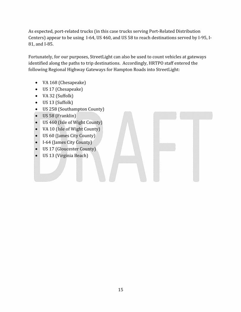
Asexpected,port‐relatedtrucks(inthiscasetrucksservingPort‐RelatedDistributionCenters)appeartobeusingI‐64,US460,andUS58toreachdestinationsservedbyI‐95,I‐81,andI‐85.Fortunately,forourpurposes,StreetLightcanalsobeusedtocountvehiclesatgatewaysidentifiedalongthepathstotripdestinations.Accordingly,HRTPOstaffenteredthefollowingRegionalHighwayGatewaysforHamptonRoadsintoStreetLight:
VA168(Chesapeake) US17(Chesapeake) VA32(Suffolk) US13(Suffolk) US258(SouthamptonCounty) US58(Franklin) US460(IsleofWightCounty) VA10(IsleofWightCounty) US60(JamesCityCounty) I‐64(JamesCityCounty) US17(GloucesterCounty) US13(VirginiaBeach)
16
FIGURE10HighwayGatewaysattheEdgeofHamptonRoadsSource:HRTPOstaffprocessingviaStreetLight(snipped)
17
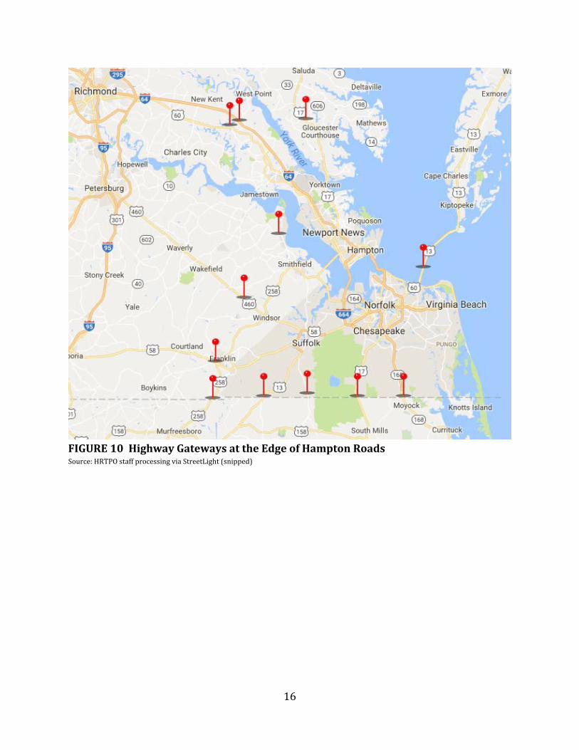
Usingthesamespecificationsasoutlinedabovefortheabovedestinationanalysis,HRTPOstaffusedStreetLighttodeterminethehighwaygatewaysusedbytrucksfromPort‐RelatedDistributionCenters.AccordingtoHRTPOstaffprocessingofStreetLightdata,thesubjectPort‐RelatedDistributionCenterscontributetotrucktrafficatthegatewaysasfollows:
FIGURE11TruckUsageofHighwayGateways,byPort‐RelatedDistributionCenterSource:HRTPOstaffprocessingofStreetLightdata,July’16thruJune’17(Port_Distr_Cntrs_1040_od_commercial.xlsx)NotethedominanceoftheWalmartdistributioncenterinJamesCityCounty.

18
AccordingtoHRTPOstaffprocessingofStreetLightdata,trucksfromPort‐RelatedDistributionCentersonthePeninsulausehighwaygatewaysasfollows:
FIGURE12UsageofGatewaysbyPeninsulaPort‐RelatedDistributionCentersSource:HRTPOstaffprocessingofStreetLightdata,July’16thruJune’17(Port_Distr_Cntrs_1040_od_commercial.xlsx)Notsurprisingly,mostofthetrucksfromPort‐RelatedDistributionCentersonthePeninsulauseI‐64toleavetheregion.Somewhatsurprisingly,asignificantnumberoftruckdriversservingdistributioncentersonthePeninsulausetheChesapeakeBayBridgeTunnel(CBBT),apparentlydrivingoutoftheirway4toavoidtrafficintheDCareawhenservingdestinationsinthenortheast.
4TheCBBTliessouthofthePeninsula.

19
AccordingtoHRTPOstaffprocessingofStreetLightdata,trucksfromPort‐RelatedDistributionCentersontheSouthsideusehighwaygatewaysasfollows:
FIGURE13UsageofGatewaysbySouthsidePort‐RelatedDistributionCentersSource:HRTPOstaffprocessingofStreetLightdata,July’16thruJune’17(Port_Distr_Cntrs_1040_od_commercial.xlsx)Notsurprisingly,manyofthetrucksfromPort‐RelatedDistributionCentersontheSouthsideuseUS58andUS460toleavetheregion.GiventhatmanydestinationsliewestandnorthofRichmond,theportionofport‐relatedtrucksusingI‐64toleaveHamptonRoads(14%,oroneoutofseven)issurprisinglysmall.Congestionattheharborcrossings(HamptonRoadsBridgeTunnel[HRBT]andMonitorMerrimacMemorialBridgeTunnel[MMMBT])andalongI‐64westoftheNewportNews–Williamsburgairportmayexplainthisresult.
20
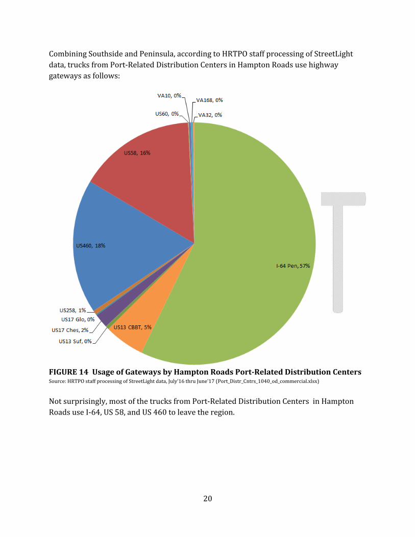
CombiningSouthsideandPeninsula,accordingtoHRTPOstaffprocessingofStreetLightdata,trucksfromPort‐RelatedDistributionCentersinHamptonRoadsusehighwaygatewaysasfollows:
FIGURE14UsageofGatewaysbyHamptonRoadsPort‐RelatedDistributionCentersSource:HRTPOstaffprocessingofStreetLightdata,July’16thruJune’17(Port_Distr_Cntrs_1040_od_commercial.xlsx)Notsurprisingly,mostofthetrucksfromPort‐RelatedDistributionCentersinHamptonRoadsuseI‐64,US58,andUS460toleavetheregion.

21
Inordertocheckthestudyresults,HRTPOstaffcomparedthestudy’smeasurementofhighwaygatewayusagebytrucksservingport‐relateddistributioncenterstoknownhighwaygatewayusagebytrucksservingallpurposes,asshownbelow:
FIGURE15UsageofGatewaysbyTrucksSource:HRTPOstaffprocessingofVDOTcountandStreetLightGPSdata(Port_Distr_Cntrs_1040_od_commercial.xlsx)Theabovecomparisonindicates:
Thetopthreegatewaysforport‐relatedtrucks,andthetopthreegatewaysforalltrucks,arethesamethreegateways:I‐64,US460,andUS58.
I‐64PeninsulaandUS460appeartobeevenmoreimportanttoport‐relatedtrucksthantheyaretoalltrucks.
0%
10%
20%
30%
40%
50%
60%
70%
I‐64 Pen US13 CBBT US13 Suf US17 Ches US17 Glo US258 US460 US58 US60 VA10 VA168 VA32
Portion of Sum of All Gateways
Trucks from Port‐Related DistributionCenters, average weekday, 7/2016‐6/2017 (StreetLight analysis by HRTPO)
All Trucks, average weekday, 2015(Regional Freight Study, HRTPO, 2017)
22
NEXTSTEPSTheHRTPOcanusetheproductofthisstudyasinputtoitsdecisionswhenplanningandfundinghighwayimprovementswithaneyetohelpingportoperations.Specifically,HRTPOstaffintendsto:
Employthestudy’smeasurementofhighwaygatewayusagebyport‐relatedtrucksinscoringcandidateprojectswiththeHRTPOPrioritizationTool(toolcomponent:“increaseaccesstoportfacilities”,10pointsforhighwayprojects)
Providethestudy’smeasurementofhighwaygatewayusagebyport‐relatedtruckstotheconsultantspreparingtheUS58ArterialManagementPlan
Providethestudy’smeasurementofhighwaygatewayusagebyport‐relatedtruckstotheconsultantspreparingtheRegionalConnectorsStudy.