Embed Size (px)
Citation preview
HSSC5-05.8A
5TH
MEETING OF THE HYDROGRAPHIC SERVICES AND STANDARDS COMMITTEE
Seagull On The Bund Hotel, Shanghai, China, 5-8 November 2013
Report of the Tidal and Water Level Working Group
Submitted by: Chairman, TWLWG Related Documents: Report of TWLWG 5 meeting (available from IHO web site). Related Projects: None
Chair: Gwenaële Jan, France
Vice-Chair: Christopher Jones, UK
Secretary: David Wyatt, IHB
Member States: Australia, Brazil, Canada, Chile, China, Cuba, Denmark, Ecuador, Finland, France, Germany, India, Indonesia, Italy, Japan, Korea Rep of, New Zealand, Norway, Portugal, South Africa, Spain, UK, Uruguay, USA, Venezuela.
Expert Contributor Organisations:
Bohdan Pillich (Tidal Expert) IOC-GLOSS
see Annex A for full details
Meetings Held During Reporting Period TWLWG 5 14 - 16 May 2013, Helsinki, Finland Next Meeting TWLWG 6 April 2014, venue Wollongong, Australia
Work Program The 5th meeting of the TWLWG took place at the offices of the Finnish Transport Agency, Pasila, Helsinki, Finland from 14 – 16 May 2013 and was hosted by the Finnish Transport Agency (FTA). The meeting was attended by 11 representatives from 9 IHO Member States and the IHB. During discussion on the Standard Constituent List (Task A), UK gave a presentation, which highlighted variations in the angular speed of harmonic tidal constituents and orbital elements based on the most helpful correspondence with the Korean delegate following TWLWG 4. It was agreed UK and France would investigate the angular speed of harmonic tidal constituents with a view to improve the precision of tide predictions; it was considered as a minimum 7 decimal places should be quoted. An update on NOAA progress towards direct time series predictions based on Chart Datum (CD) for on-line availability was provided via teleconference link. It was noted where sufficient information was available for harmonic analysis for predicted tides; this was being conducted whilst maintaining time and height for areas of sparse data. It was highlighted NOAA intend to move away from domestic hard copy tide tables but the issue of international uses still required to be addressed. The draft document, which contained suggested feature attributes to be included in digital tide tables, was brought to the attention of all participants. A background brief on S-100 Product Specifications was provided with additional information provided by the IHB via teleconference, particularly guidance on the appropriate initial areas to be discussed and considered within the TWLWG capabilities. The use of gridded data component should be an area for further discussion. It was agreed that the WG concentrate on the product that will be used in the ECDIS first and leave the transfer format
for later. It was suggested once the WG has a clear understanding of the nature of the requirement, it will be in a better position to define components / services that are needed make it happen. It was recognised that what is required is a type of bathymetric attributed grid/ product that can be used as a layer within an ECDIS. The grid would be based on full resolution survey data, and the choice of grid interval would be determined by the quality of the underlying survey data and the intended use; i.e. in a port area where depths are critical and tidal variations significant, a small (fine) grid interval grid would be more appropriate (provided that the underlying survey data can support it) than a course one. It was noted that the depth information in existing ENC is not sufficiently comprehensive to support this type of application and therefore some form of time variable layer based on a gridded bathymetric surface or triangulated irregular network (TIN) surface would be more viable.
The gridded dataset would effectively become a navigational surface (based on chart datum CD), and the next issue to consider would be how to apply the tidal model including the temporal component to the navigational surface in order that CD depths are adjusted to reflect the tidal / time variables. The tide adjusted depth at each grid cell would drive the portrayal within the EDCIS. This could simply be as a colour coded bathymetric surfaces, or green (safe) amber (beware) and red (no go) areas based on the vessels draft. It was noted a number of there are a number of issues that may need further discussion such as;
a. appropriate metadata for data quality, grid resolution, source bathymetry, tidal regime portrayal; b. what would trigger alarms (e.g. grounding alarm etc …) in the ECDIS.
A basic outline scope requirement was generated for review by TSMAD, see Annex B.
As a result of considerable intersessional correspondence and further work during the meeting, the review into IHO Resolution 3/1919, as amended, (Datums and Benchmarks) was brought to a conclusion. Finland briefed on the discussions and principles involved, including a detailed explanation on the complex issues between adjacent areas and how these could be considered by national HOs. The main challenges were the articulation of the correct terminology for areas connected to ocean areas with appreciable variations of water level and areas with minimal variation in water level and limited connection to oceans. An agreed text to IHO Resolution 3-1919, as amended, was generated for submission to HSSC 5 and subsequent Member State approval, see Annex C. A minor amendment to IHO Resolution 2/1977, as amended, (National TIDAL Constituent Banks) was proposed to reflect the new WG title, see Annex D. It was agreed a revised text for IHO Resolution 27/1919, as amended, (Time To Be Used) was required to reflect the supply of digital tidal data; the proposed revised text for submission to HSSC 5 and subsequent Member State approval is at Annex E. Revision of IHO Resolution 27/1919, as amended, highlighted a need for a minor amendment to IHO Resolution 1/1977, as amended, see Annex F. Concerns were raised over the consistency with other related IHO publications, in particular S-4 and C-13. In response to an output from an IHO/EU bilateral meeting, the TWLWG were invited to investigate the establishment and maintenance of vertical reference frameworks for the high resolution bathymetric surfaces. UK briefed on background and work in progress by NSHCTWG and previous work undertaken by Belgium, Denmark, Germany, France, Netherlands, Norway and UK. It was noted similar work was being undertaken by France and Norway. Sweden highlighted associated work and the connection with the EVR System and its similarities with the EVRF and the move towards a common reference model. UK articulated the actions required and noted the liaison required with NSHCTWG, of which France, Norway and UK were members, in addition to Belgium, Denmark, Germany and Netherlands. In addition the work undertaken by the Netherlands and the BLAST Project were noted. Sweden highlighted a paper from the University of Southern Mississippi on a similar subject and Chile noted the large quantity of work already being undertaken by specialists in various countries and organizations, including the associated workshops on Geodetic Vertical Monitoring developed in
conjunction of the sessions of the Group of Experts of GLOSS. Feedback and comment for the following bilateral IHO/EU meeting was subsequently coordinated by the UK. Correspondence with CSPCWG regarding sections of publication S-4, which relate to tidal issues, were discussed. It was agreed to recommend to HSSC 5 to move Resolution 1/2008, as amended, from Section 2.3.1 to Section 2.2 of IHO publication M-3. After further discussion it was felt Resolution 3/1947, as amended, still had relevance and a number of occurrences on charts where this Resolution applied. It was felt there remained a need to retain this Resolution. TWLWG wished to liaise further with CSPCWG before providing any recommendation on the removal of Resolution 3/1947. In addition it was considered S-4 may require further review by CSPCWG once the revised wording to Resolution 3/1919 has been approved by Member States. In the draft Work Plan, attached at Annex G, the completion dates for some items have been amended to reflect progress made to date.
Progress on HSSC Action Items
N/A
Problems Encountered N/A
Any Other Items of Note N/A
Conclusions and Recommended Actions N/A
Justification and Impacts
N/A
Action Required of HSSC
The HSSC is invited to:
a. note this report
b. re-appoint the TWLWG to continue its work under its current Terms of Reference
c. endorse the draft Work Plan at Annex G
d. approve the draft IHO Resolution 3/1919 as amended, (Datums and Benchmarks) and
the definitions of Low Water, Mean Water and High Water for submission to IHO
Member States at Annex C.
e. approve the minor amendment to IHO Resolution 2/1977, as amended, (National Tidal
Constituent Banks), Annex D .
f. approve the draft revised text for IHO Resolution 27/1919, as amended, (Time to be
Used), Annex E.
g. approve the minor amendment to IHO Resolution 1/1977, as amended, (Collection and
Publication of Tidal Data), Annex F.
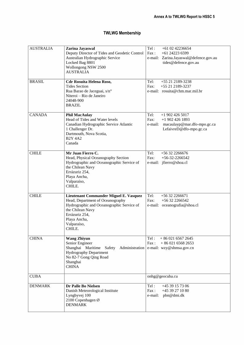
Annex A to TWLWG Report to HSSC 5
TWLWG Membership
AUSTRALIA Zarina Jayaswal
Deputy Director of Tides and Geodetic Control
Australian Hydrographic Service
Locked Bag 8801
Wollongong NSW 2500
AUSTRALIA
Tel : +61 02 42236654
Fax : +61 24223 6599
e-mail: [email protected]
BRASIL
Cdr Rosuita Helena Roso,
Tides Section
Rua Barao de Jaceguai, s/n°
Niteroi – Rio de Janeiro
24048-900
BRAZIL
Tel: +55 21 2189-3238
Fax: +55 21 2189-3237
e-mail: [email protected]
CANADA Phil MacAulay Head of Tides and Water levels
Canadian Hydrographic Service Atlantic
1 Challenger Dr.
Dartmouth, Nova Scotia,
B2Y 4A2
Canada
Tel: +1 902 426 5017 Fax: +1 902 426 1893
e-mail: [email protected]
CHILE Mr Juan Fierro C.
Head, Physical Oceanography Section
Hydrographic and Oceanographic Service of
the Chilean Navy
Errázuriz 254,
Playa Ancha,
Valparaíso,
CHILE.
Tel: +56 32 2266676
Fax: +56-32-2266542
e-mail: [email protected]
CHILE Lieutenant Commander Miguel E. Vasquez Head, Department of Oceanography
Hydrographic and Oceanographic Service of
the Chilean Navy
Errázuriz 254,
Playa Ancha,
Valparaíso,
CHILE.
Tel: +56 32 2266671
Fax: +56 32 2266542
e-mail: [email protected]
CHINA
Wang Zhiyun Senior Engineer
Shanghai Maritime Safety Administration
Hydrography Department
No 82-7 Gong Qing Road
Shanghai
CHINA
Tel : + 86 021 6567 2645
Fax : + 86 021 6568 2653
e-mail: [email protected]
CUBA [email protected]
DENMARK Dr Palle Bo Nielsen
Danish Meteorological Institute
Lyngbyvej 100
2100 Copenhagen Ø
DENMARK
Tel : +45 39 15 73 06
Fax : +45 39 27 10 80
e-mail: [email protected]
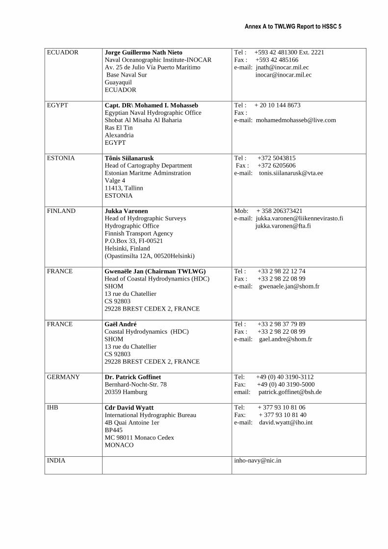
Annex A to TWLWG Report to HSSC 5
ECUADOR Jorge Guillermo Nath Nieto
Naval Oceanographic Institute-INOCAR
Av. 25 de Julio Vía Puerto Marítimo
Base Naval Sur
Guayaquil
ECUADOR
Tel : +593 42 481300 Ext. 2221
Fax : +593 42 485166
e-mail: [email protected]
EGYPT Capt. DR\ Mohamed I. Mohasseb
Egyptian Naval Hydrographic Office
Shobat Al Misaha Al Baharia
Ras El Tin
Alexandria
EGYPT
Tel : + 20 10 144 8673
Fax :
e-mail: [email protected]
ESTONIA Tõnis Siilanarusk
Head of Cartography Department
Estonian Maritme Adminstration
Valge 4
11413, Tallinn
ESTONIA
Tel : +372 5043815
Fax : +372 6205606
e-mail: [email protected]
FINLAND Jukka Varonen
Head of Hydrographic Surveys
Hydrographic Office
Finnish Transport Agency
P.O.Box 33, FI-00521
Helsinki, Finland
(Opastinsilta 12A, 00520Helsinki)
Mob: + 358 206373421
e-mail: [email protected]
FRANCE Gwenaële Jan (Chairman TWLWG)
Head of Coastal Hydrodynamics (HDC)
SHOM
13 rue du Chatellier
CS 92803
29228 BREST CEDEX 2, FRANCE
Tel : +33 2 98 22 12 74
Fax : +33 2 98 22 08 99
e-mail: [email protected]
FRANCE Gaël André
Coastal Hydrodynamics (HDC)
SHOM
13 rue du Chatellier
CS 92803
29228 BREST CEDEX 2, FRANCE
Tel : +33 2 98 37 79 89
Fax : +33 2 98 22 08 99
e-mail: [email protected]
GERMANY Dr. Patrick Goffinet
Bernhard-Nocht-Str. 78
20359 Hamburg
Tel: +49 (0) 40 3190-3112
Fax: +49 (0) 40 3190-5000
email: [email protected]
IHB Cdr David Wyatt International Hydrographic Bureau
4B Quai Antoine 1er
BP445
MC 98011 Monaco Cedex
MONACO
Tel: + 377 93 10 81 06
Fax: + 377 93 10 81 40
e-mail: [email protected]
INDIA
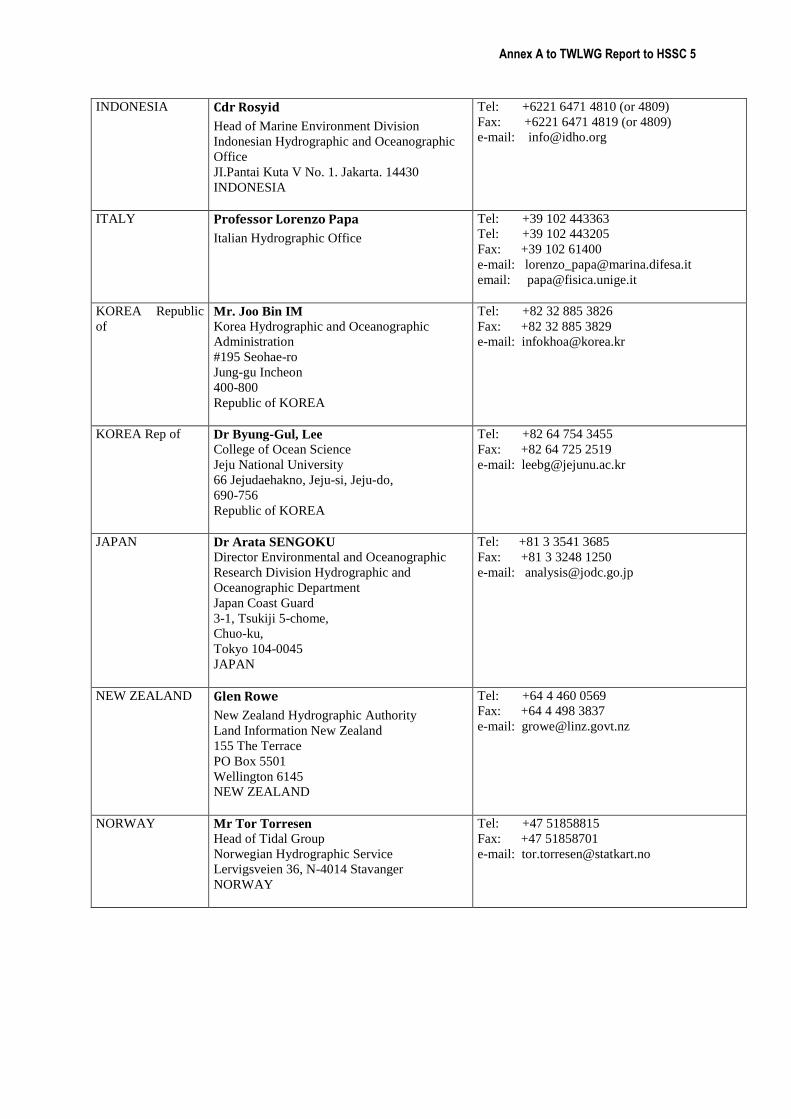
Annex A to TWLWG Report to HSSC 5
INDONESIA Cdr Rosyid
Head of Marine Environment Division
Indonesian Hydrographic and Oceanographic
Office
JI.Pantai Kuta V No. 1. Jakarta. 14430
INDONESIA
Tel: +6221 6471 4810 (or 4809)
Fax: +6221 6471 4819 (or 4809)
e-mail: [email protected]
ITALY Professor Lorenzo Papa
Italian Hydrographic Office
Tel: +39 102 443363
Tel: +39 102 443205
Fax: +39 102 61400
e-mail: [email protected]
email: [email protected]
KOREA Republic
of Mr. Joo Bin IM
Korea Hydrographic and Oceanographic
Administration
#195 Seohae-ro
Jung-gu Incheon
400-800
Republic of KOREA
Tel: +82 32 885 3826
Fax: +82 32 885 3829
e-mail: [email protected]
KOREA Rep of Dr Byung-Gul, Lee College of Ocean Science
Jeju National University
66 Jejudaehakno, Jeju-si, Jeju-do,
690-756
Republic of KOREA
Tel: +82 64 754 3455
Fax: +82 64 725 2519
e-mail: [email protected]
JAPAN Dr Arata SENGOKU
Director Environmental and Oceanographic
Research Division Hydrographic and
Oceanographic Department
Japan Coast Guard
3-1, Tsukiji 5-chome,
Chuo-ku,
Tokyo 104-0045
JAPAN
Tel: +81 3 3541 3685
Fax: +81 3 3248 1250
e-mail: [email protected]
NEW ZEALAND Glen Rowe
New Zealand Hydrographic Authority
Land Information New Zealand
155 The Terrace
PO Box 5501
Wellington 6145
NEW ZEALAND
Tel: +64 4 460 0569
Fax: +64 4 498 3837
e-mail: [email protected]
NORWAY Mr Tor Torresen
Head of Tidal Group
Norwegian Hydrographic Service
Lervigsveien 36, N-4014 Stavanger
NORWAY
Tel: +47 51858815
Fax: +47 51858701
e-mail: [email protected]
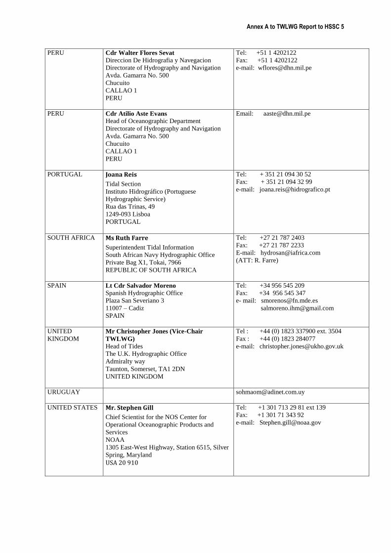
Annex A to TWLWG Report to HSSC 5
PERU Cdr Walter Flores Sevat
Direccion De Hidrografia y Navegacion
Directorate of Hydrography and Navigation
Avda. Gamarra No. 500
Chucuito
CALLAO 1
PERU
Tel: +51 1 4202122
Fax: +51 1 4202122
e-mail: [email protected]
PERU Cdr Atilio Aste Evans
Head of Oceanographic Department
Directorate of Hydrography and Navigation
Avda. Gamarra No. 500
Chucuito
CALLAO 1
PERU
Email: [email protected]
PORTUGAL Joana Reis
Tidal Section
Instituto Hidrográfico (Portuguese
Hydrographic Service)
Rua das Trinas, 49
1249-093 Lisboa
PORTUGAL
Tel: + 351 21 094 30 52
Fax: + 351 21 094 32 99 e-mail: [email protected]
SOUTH AFRICA
Ms Ruth Farre
Superintendent Tidal Information
South African Navy Hydrographic Office
Private Bag X1, Tokai, 7966
REPUBLIC OF SOUTH AFRICA
Tel: +27 21 787 2403
Fax: +27 21 787 2233
E-mail: [email protected]
(ATT: R. Farre)
SPAIN
Lt Cdr Salvador Moreno
Spanish Hydrographic Office
Plaza San Severiano 3
11007 – Cadiz
SPAIN
Tel: +34 956 545 209
Fax: +34 956 545 347
e- mail: [email protected]
UNITED
KINGDOM Mr Christopher Jones (Vice-Chair
TWLWG)
Head of Tides
The U.K. Hydrographic Office
Admiralty way
Taunton, Somerset, TA1 2DN
UNITED KINGDOM
Tel : +44 (0) 1823 337900 ext. 3504
Fax : +44 (0) 1823 284077
e-mail: [email protected]
URUGUAY [email protected]
UNITED STATES Mr. Stephen Gill
Chief Scientist for the NOS Center for
Operational Oceanographic Products and
Services
NOAA
1305 East-West Highway, Station 6515, Silver
Spring, Maryland
USA 20 910
Tel: +1 301 713 29 81 ext 139
Fax: +1 301 71 343 92
e-mail: [email protected]
Annex A to TWLWG Report to HSSC 5
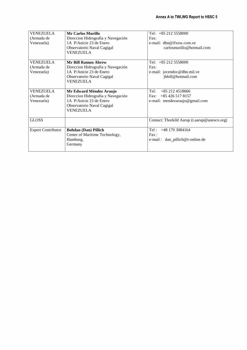
VENEZUELA
(Armada de
Venezuela)
Mr Carlos Murillo
Direccion Hidrografia y Navegación
1A P/Anicie 23 de Enero
Observatorio Naval Cagigal
VENEZUELA
Tel: +85 212 5558000
Fax:
e-mail: [email protected]
VENEZUELA
(Armada de
Venezuela)
Mr Bill Ramon Abrew
Direccion Hidrografia y Navegación
1A P/Anicie 23 de Enero
Observatorio Naval Cagigal
VENEZUELA
Tel: +85 212 5558000
Fax:
e-mail: [email protected]
VENEZUELA
(Armada de
Venezuela)
Mr Edward Méndez Araujo
Direccion Hidrografia y Navegación
1A P/Anicie 23 de Enero
Observatorio Naval Cagigal
VENEZUELA
Tel: +85 212 4518666
Fax: +85 426 517 8157
e-mail: [email protected]
GLOSS
Contact: Thorkild Aarup ([email protected])
Expert Contributor Bohdan (Dan) Pillich
Center of Maritime Technology,
Hamburg,
Germany
Tel : +48 170 3084164
Fax :
e-mail : [email protected]
Annex G to TWLWG Report to HSSC 5
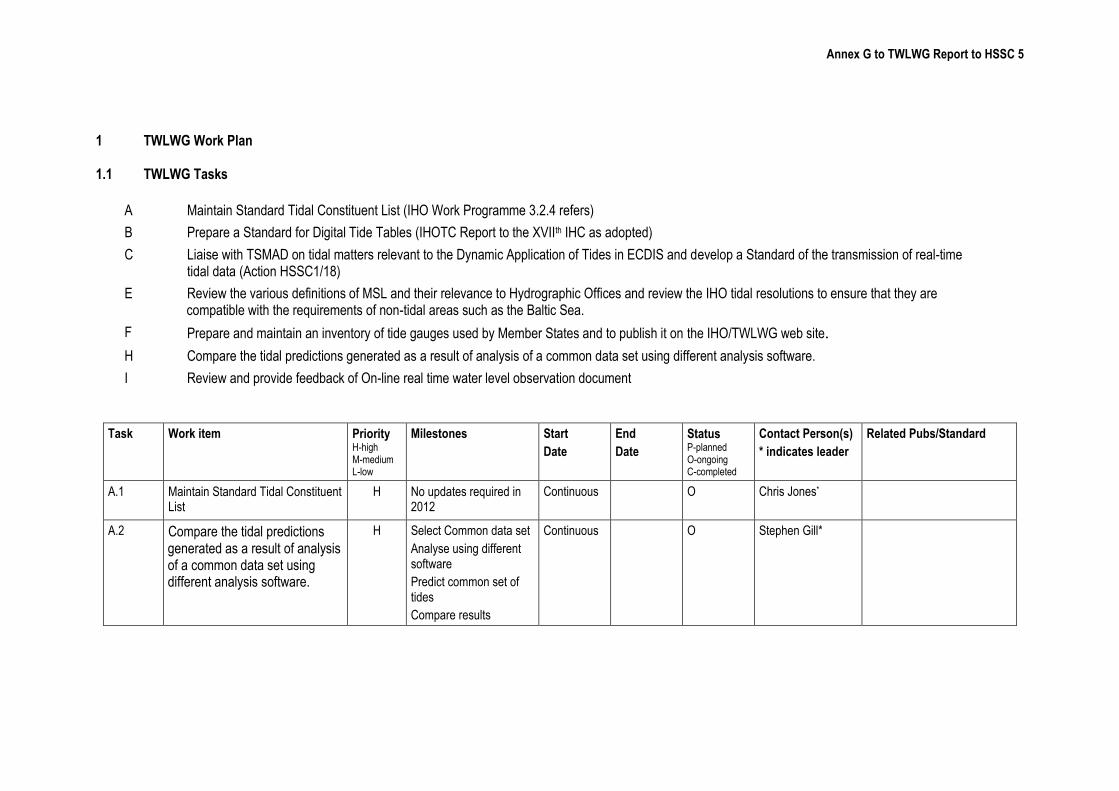
1 TWLWG Work Plan 1.1 TWLWG Tasks
A Maintain Standard Tidal Constituent List (IHO Work Programme 3.2.4 refers)
B Prepare a Standard for Digital Tide Tables (IHOTC Report to the XVIIth IHC as adopted)
C Liaise with TSMAD on tidal matters relevant to the Dynamic Application of Tides in ECDIS and develop a Standard of the transmission of real-time tidal data (Action HSSC1/18)
E Review the various definitions of MSL and their relevance to Hydrographic Offices and review the IHO tidal resolutions to ensure that they are compatible with the requirements of non-tidal areas such as the Baltic Sea.
F Prepare and maintain an inventory of tide gauges used by Member States and to publish it on the IHO/TWLWG web site.
H Compare the tidal predictions generated as a result of analysis of a common data set using different analysis software.
I Review and provide feedback of On-line real time water level observation document
Task Work item Priority H-high M-medium L-low
Milestones Start
Date
End
Date
Status P-planned O-ongoing C-completed
Contact Person(s)
* indicates leader
Related Pubs/Standard
A.1 Maintain Standard Tidal Constituent List
H No updates required in 2012
Continuous O Chris Jones*
A.2 Compare the tidal predictions generated as a result of analysis of a common data set using different analysis software.
H Select Common data set
Analyse using different software
Predict common set of tides
Compare results
Continuous O Stephen Gill*
Annex G to TWLWG Report to HSSC 5
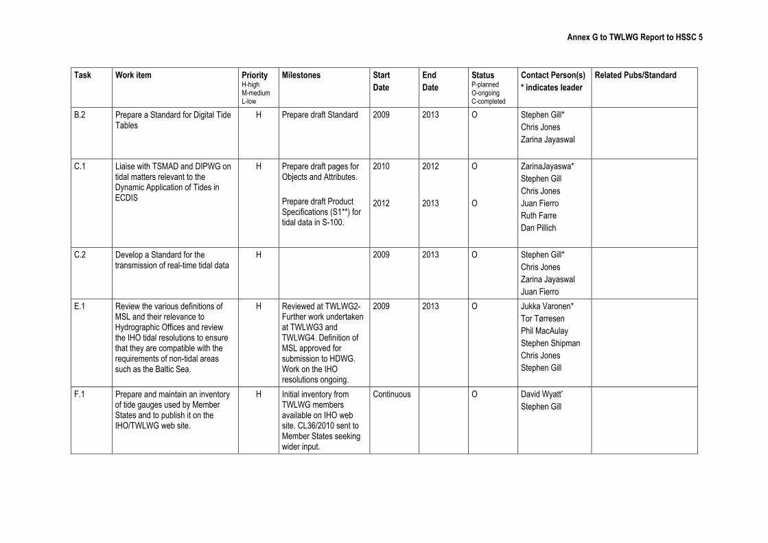
Task Work item Priority H-high M-medium L-low
Milestones Start
Date
End
Date
Status P-planned O-ongoing C-completed
Contact Person(s)
* indicates leader
Related Pubs/Standard
B.2 Prepare a Standard for Digital Tide Tables
H Prepare draft Standard 2009 2013 O Stephen Gill*
Chris Jones
Zarina Jayaswal
C.1 Liaise with TSMAD and DIPWG on tidal matters relevant to the Dynamic Application of Tides in ECDIS
H Prepare draft pages for Objects and Attributes.
Prepare draft Product Specifications (S1**) for tidal data in S-100.
2010
2012
2012
2013
O
O
ZarinaJayaswa*
Stephen Gill
Chris Jones
Juan Fierro
Ruth Farre
Dan Pillich
C.2 Develop a Standard for the transmission of real-time tidal data
H 2009 2013 O Stephen Gill*
Chris Jones
Zarina Jayaswal
Juan Fierro
E.1 Review the various definitions of MSL and their relevance to Hydrographic Offices and review the IHO tidal resolutions to ensure that they are compatible with the requirements of non-tidal areas such as the Baltic Sea.
H Reviewed at TWLWG2- Further work undertaken at TWLWG3 and TWLWG4. Definition of MSL approved for submission to HDWG. Work on the IHO resolutions ongoing.
2009 2013 O Jukka Varonen*
Tor Tørresen
Phil MacAulay
Stephen Shipman
Chris Jones
Stephen Gill
F.1 Prepare and maintain an inventory of tide gauges used by Member States and to publish it on the IHO/TWLWG web site.
H Initial inventory from TWLWG members available on IHO web site. CL36/2010 sent to Member States seeking wider input.
Continuous O David Wyatt*
Stephen Gill
Annex G to TWLWG Report to HSSC 5
Task Work item Priority H-high M-medium L-low
Milestones Start
Date
End
Date
Status P-planned O-ongoing C-completed
Contact Person(s)
* indicates leader
Related Pubs/Standard
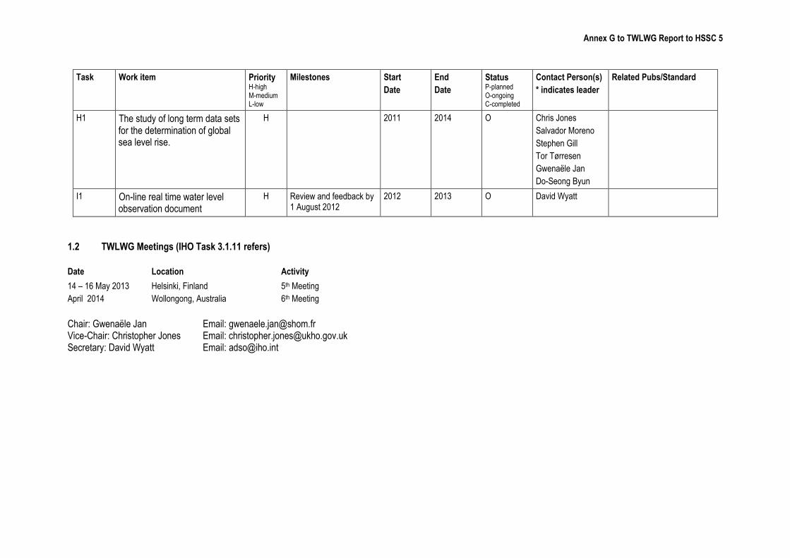
H1 The study of long term data sets for the determination of global sea level rise.
H 2011 2014 O Chris Jones
Salvador Moreno
Stephen Gill
Tor Tørresen
Gwenaële Jan
Do-Seong Byun
I1 On-line real time water level observation document
H Review and feedback by 1 August 2012
2012 2013 O David Wyatt
1.2 TWLWG Meetings (IHO Task 3.1.11 refers)
Date Location Activity
14 – 16 May 2013
April 2014
Helsinki, Finland
Wollongong, Australia
5th Meeting
6th Meeting
Chair: Gwenaële Jan Email: [email protected] Vice-Chair: Christopher Jones Email: [email protected] Secretary: David Wyatt Email: [email protected]
Annex C to TWLWG Report to HSSC 5
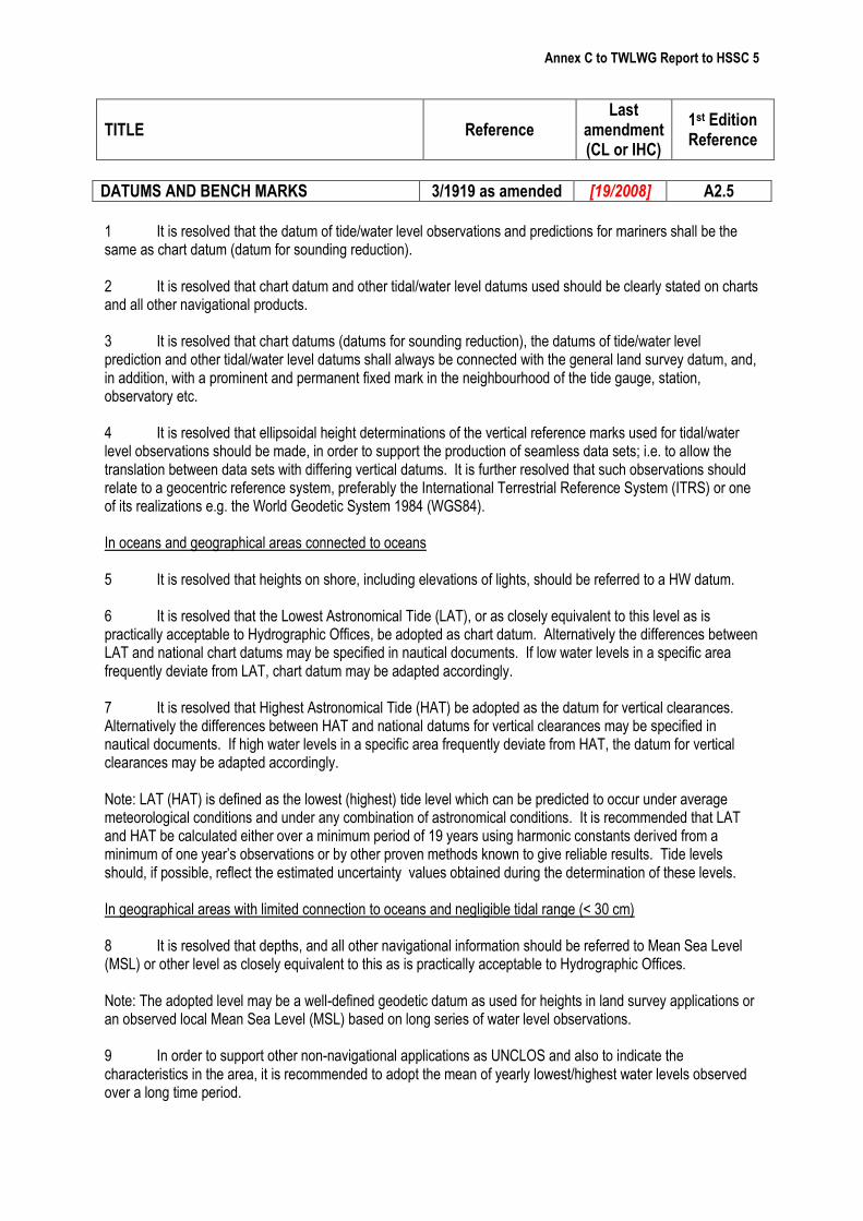
DATUMS AND BENCH MARKS 3/1919 as amended [19/2008] A2.5
1 It is resolved that the datum of tide/water level observations and predictions for mariners shall be the same as chart datum (datum for sounding reduction). 2 It is resolved that chart datum and other tidal/water level datums used should be clearly stated on charts and all other navigational products. 3 It is resolved that chart datums (datums for sounding reduction), the datums of tide/water level prediction and other tidal/water level datums shall always be connected with the general land survey datum, and, in addition, with a prominent and permanent fixed mark in the neighbourhood of the tide gauge, station, observatory etc. 4 It is resolved that ellipsoidal height determinations of the vertical reference marks used for tidal/water level observations should be made, in order to support the production of seamless data sets; i.e. to allow the translation between data sets with differing vertical datums. It is further resolved that such observations should relate to a geocentric reference system, preferably the International Terrestrial Reference System (ITRS) or one of its realizations e.g. the World Geodetic System 1984 (WGS84). In oceans and geographical areas connected to oceans 5 It is resolved that heights on shore, including elevations of lights, should be referred to a HW datum. 6 It is resolved that the Lowest Astronomical Tide (LAT), or as closely equivalent to this level as is practically acceptable to Hydrographic Offices, be adopted as chart datum. Alternatively the differences between LAT and national chart datums may be specified in nautical documents. If low water levels in a specific area frequently deviate from LAT, chart datum may be adapted accordingly. 7 It is resolved that Highest Astronomical Tide (HAT) be adopted as the datum for vertical clearances. Alternatively the differences between HAT and national datums for vertical clearances may be specified in nautical documents. If high water levels in a specific area frequently deviate from HAT, the datum for vertical clearances may be adapted accordingly. Note: LAT (HAT) is defined as the lowest (highest) tide level which can be predicted to occur under average meteorological conditions and under any combination of astronomical conditions. It is recommended that LAT and HAT be calculated either over a minimum period of 19 years using harmonic constants derived from a minimum of one year’s observations or by other proven methods known to give reliable results. Tide levels should, if possible, reflect the estimated uncertainty values obtained during the determination of these levels. In geographical areas with limited connection to oceans and negligible tidal range (< 30 cm) 8 It is resolved that depths, and all other navigational information should be referred to Mean Sea Level (MSL) or other level as closely equivalent to this as is practically acceptable to Hydrographic Offices. Note: The adopted level may be a well-defined geodetic datum as used for heights in land survey applications or an observed local Mean Sea Level (MSL) based on long series of water level observations. 9 In order to support other non-navigational applications as UNCLOS and also to indicate the characteristics in the area, it is recommended to adopt the mean of yearly lowest/highest water levels observed over a long time period.
TITLE Reference Last
amendment (CL or IHC)
1st Edition Reference
Annex C to TWLWG Report to HSSC 5
Inland Waters 10 It is resolved that depths, and all other navigational information should be referred to an appropriate level practically acceptable to Hydrographic Offices or if needed LW as a reference level for depths and HW for vertical clearances. The selection of which one of the alternatives to be used is a difficult issue which can only be determined locally and which will be largely dependent on seasonal hydrological conditions. LW and HW are defined preferably as the mean of lowest/highest water levels, or as a suitable percentile of lowest/highest water levels, observed over a long time period.
Annex D to TWLWG Report to HSSC 5
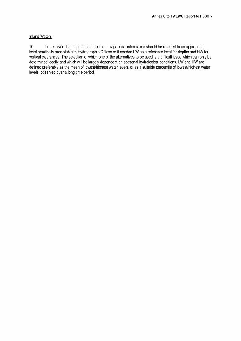
NATIONAL TIDAL CONSTITUENT BANKS 2/1977 as amended 42/2000 A6.8
It is resolved that the National Tidal Constituent Banks should store the following information for each location:
a) Location identification by number, name, country, body of water, and geographic coordinates; b) Source, date, time zone, and duration of data used in analysis; c) Identification of geodetic levelling datum, and date of reference to this datum, elevation of mean sea level and, where applicable, the connection to and identification of the appropriate bench mark(s); and d) Listing of values for tidal constituents giving amplitudes in metres and Greenwich phase lags in degrees and designation of organization responsible for analysis. (Tidal constituents used should form part of those in the Standard List prepared by the IHOTC TWLWG and published on the IHO website.)
See also 9/1919 (A 6.1) and 10/1919 (A 6.2).
Annex E to TWLWG Report to HSSC 5
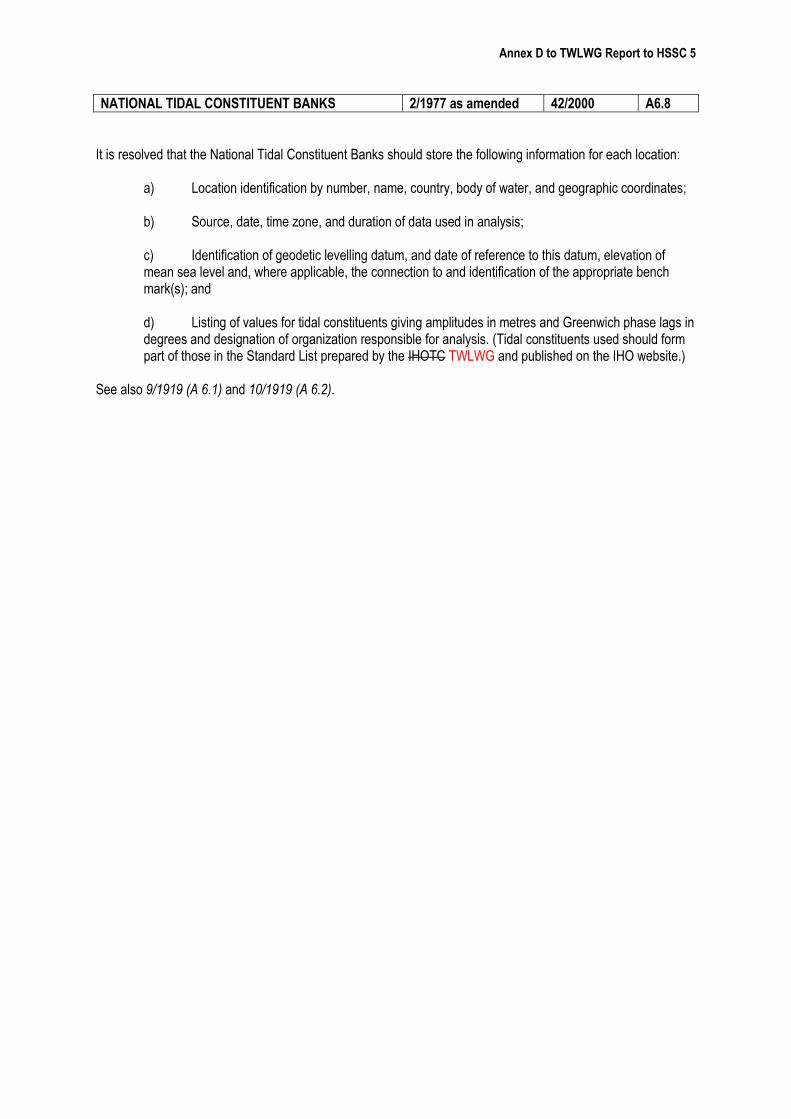
TIME TO BE USED 27/1919 as amended G1.2
It is resolved that the time system employed in printed Tide Tables shall be that actually used Standard Time as observed at the port. It is resolved that daylight saving time shall not be used in the predictions in the printed Tide Tables but that a notice or caution relative to its use and the period of its application shall be included therein. It is strongly recommended that the time system employed in Digital Tide Tables (DTT) published in web sites shall be Standard Time as observed at the port, without daylight saving time application. A notice or caution relative to its use and the period of its application shall be included therein. Additionally, DTT can offer to the user the possibility to set automatically another time system.
Annex F to TWLWG Report to HSSC 5
COLLECTION AND PUBLICATION OF TIDAL DATA 1/1977 as amended 42/2000 A6.7
It is recommended that Member States gather tidal data from as many locations as feasible and maintain sets of harmonic constants in National Tidal Constituent Data Banks. It is recommended that Member States make public, using their WEB website or other suitable means, tidal and tidal stream predictions and a list of locations included in their own Tidal Constituent Data Banks.
Annex B to TWLWG Report to HSSC 5
‘Scoping Document’ Dynamic Tides and Water Levels in ECDIS Basic Outline Scope and Requirement Generate a time variable layer which displays, as designated by the user, the appropriate available safe water on an ENC in an ECDIS. Depth variability should be based on the available gridded bathymetric surface or triangulated irregular network (TIN) surface, with water level predictions or near real-time observations, generated from single point, simple zone model, complex zone model or co-tidal models. Also it should be based on forecast meteorological surge where these are available. The display should be capable of showing predicted tides for voyage planning and near real-time tides for voyage execution. The metadata associated with the display should be available with the delivered tidal data. Deliver this information with an ENC, or make it available to be applied to an ENC in an ECDIS.


![IHO S-100: The New IHO Hydrographic Geospatial … hydrographic review may 2009 →iho s-100) iho s-100 [] .Published in: International Hydrographic Review · 2009Authors: Robert Ward](https://img.pdfslide.us/doc/110x75/5ae4a48c7f8b9a495c8ed661/iho-s-100-the-new-iho-hydrographic-geospatial-hydrographic-review-may-2009.jpg)