Embed Size (px)
Citation preview
REPLACEMENT OF TIMBER TRUSS BRIDGE OVER THE CROOKWELL RIVER, MR 54 BINDA ROAD, CROOKWELL
Review of environmental factors JUNE 2013 RMS/PUB 13.354 ISBN 978-1-922245-60-1

MONTH/YEAR
(blank page)
Prepared by nghenvironmental
18/21 mary st surry hills nsw 2010 australia t (02) 8202 8333
www.nghenvironmental.com.au e [email protected]
po box 434 bathurst nsw 2795 australia
0488 820 748
suite 1, 216 carp st (po box 470) bega nsw 2550 australia
t (02) 6492 8333
suite 1, 39 fitzmaurice st (po box 5464) wagga wagga nsw 2650 australia
t (02) 6971 9696
room 15 341 havanna st (po box 434) bathurst nsw 2795
t 69719696
unit 17/27 yallourn st (po box 1037) fyshwick act 2609 australia
t (02) 6280 5053
suite 7, 5/18 griffin dr (po box 1037) dunsborough wa 6281 australia
t (08) 9759 1985
Roads and Maritime Services
Replacement of Timber Truss Bridge over the Crookwell River, MR54 Binda Road, Crookwell
Review of environmental factors
June 2013
Document Verification
Project Title: Replacement of Timber Truss Bridge over the Crookwell River, MR54 Binda Road, Crookwell
Project Number: 4948
Project File Name: Environment Crookwell Bridge REF final_170613.docx
Revision Date Prepared by (name) Reviewed by (name) Approved by (name)
Draft v1.0
7.3.2013 Jonathan Dowling Raphael Morgan Raphael Morgan
Final draft v1.0
23.5.2013
Jonathan Dowling Raphael Morgan Raphael Morgan
Final v1.0
18.06.2013
Jonathan Dowling Raphael Morgan Raphael Morgan
nghenvironmental prints all documents on environmentally sustainable paper including paper made from
bagasse (a by-product of sugar production) or recycled paper.
nghenvironmental is a registered trading name of nghenvironmental Pty Ltd; ACN: 124 444 622.
ABN: 31 124 444 622
Replacement of Truss Bridge over the Crookwell River i Review of Environmental Factors
Executive summary
The proposal
Roads and Maritime Services (RMS) proposes to replace the existing Truss Bridge over Crookwell River, MR54 Binda Road, about 10 kilometres north of Crookwell Township. The proposal is located in the Upper Lachlan Shire Local Government Area. The proposal comprises demolition and replacement of the timber truss bridge over the Crookwell River and about 700 metres of road works on the approaches to the bridge. The timber truss bridge is listed as a local heritage item in the Upper Lachlan Shire LEP and is listed on the RMS section 170 Heritage and Conservation Register.
Need for the proposal
The Timber Truss Bridge over Crookwell River was identified for replacement as part of the ‘Bridges for the Bush’ initiative to meet the demand for increased access of larger, safer and heavier freight vehicles to provide the benefit to freight productivity on NSW roads. The replacement of the bridge is in accordance with the Timber Truss Road Bridges – A Strategic Approach to Conservation Strategy. The existing timber truss bridge across Crookwell River is a single span, single lane bridge for both traffic directions. Maintenance costs have continued to increase due to the labour intensive work needed to maintain the bridge. A new bridge would provide one travel lane in each direction, two metre shoulders to allow for cyclists, upgraded road approaches and improved safety. The new bridge would also improve the capacity of the NSW freight network as it would carry Higher Mass Limit (HML) vehicles.
Options considered
The following options were considered:
Do nothing option.
Construction of a 3-span 35 metre long bridge (preferred option).
Construction of a 2-span 35 metre long bridge.
Construction of a single span bridge.
Construction of a new bridge 15 metres upstream from the centre line of the existing timber truss bridge.
Construction of a new bridge on the existing alignment. The preferred option is to construct of a 3-span 35 metre long bridge because it is cost-effective, relatively easy to construct and potential environmental impacts can be mitigated by standard safeguards.
Statutory and planning framework
RMS is the proponent and determining authority for the proposed works. By adopting the requirements of the State Environmental Planning Policy (Infrastructure) 2007, the proposed works may be carried out without the need for development consent from the Upper Lachlan Shire Council. The proposal is subject to an environmental
Replacement of Truss Bridge over the Crookwell River ii Review of Environmental Factors
impact assessment under Part 5 of the Environmental Planning and Assessment Act 1979.
Community and stakeholder consultation
RMS has consulted with the local community using the following:
Community update newsletter in February 2013.
Project website with project information, maps and photographs.
A media release inviting comment on the proposal in February 2013.
Telephone calls to key stakeholders. RMS would consult with Upper Lachlan Shire Council in accordance with State Environmental Planning Policy (Infrastructure) 2007 because the proposal would impact a locally significant heritage item. RMS would undertake a delisting process with the Heritage Branch because it is a statutory requirement when demolishing items listed on a section 170 register. RMS would consult with DPI (Fisheries) NSW because the piling and scour protection works in the river bed would be classed as dredging and reclamation under the Fisheries Management Act 1994.
Environmental impacts
The proposal would require the removal of about 1.1 hectares of vegetation. The vegetation to be removed is mainly exotic grassland. No threatened species would be impacted by the proposed works. Temporary construction noise impacts are predicted at four residential properties though these would not be highly noise affected. The proposal is not predicted to result in operational noise impacts. The proposal would result in the demolition of Crookwell Timber Truss Bridge, a locally significant heritage item listed on the RMS s.170 heritage register. Demolition of the bridge has the potential to dislodge lead paint, causing soil and water contamination. The demolition, piling and construction activities near the river have the potential to cause sedimentation. The scour protection works would have a positive impact on the hydrology and reduce the release of sediment to the river. The proposal would result in some traffic disruptions during construction but no full road closures would be required. The implementation of safeguards and management measures would minimise or avoid potential impacts.
Justification and conclusion
The proposal would provide a two-lane bridge that would improve the freight network and provide improved driving conditions for motorists. The proposal would also result in reduced maintenance costs. The impacts caused by the proposal to the environment would generally be minor and mostly temporary with the implementation of the recommended safeguards. The proposed works are considered justified as

Replacement of Truss Bridge over the Crookwell River iii Review of Environmental Factors
they would meet all objectives of the proposal with mostly minor environmental impacts.
Replacement of Truss Bridge over the Crookwell River iv Review of Environmental Factors
Contents
Executive summary ................................................................................................................................... i
1 Introduction ......................................................................................................................................... 1
1.1 Proposal identification ............................................................................................................... 1
1.2 Purpose of the report ................................................................................................................. 2
2 Need and options considered ..................................................................................................... 4
2.1 Strategic need for the proposal .............................................................................................. 4
2.2 Existing road and infrastructure ............................................................................................. 5
2.3 Proposal objectives..................................................................................................................... 6
2.4 Alternatives and options considered .................................................................................... 6
2.5 Preferred option ........................................................................................................................... 8
3 Description of the proposal .......................................................................................................... 9
3.1 The proposal.................................................................................................................................. 9
3.2 Design .............................................................................................................................................. 9
3.3 Construction activities ............................................................................................................. 10
3.4 Ancillary facilities ...................................................................................................................... 16
3.5 Public utility adjustment ......................................................................................................... 17
3.6 Property acquisition ................................................................................................................. 17
4 Statutory and planning framework ......................................................................................... 18
4.1 State Environmental Planning Policies ............................................................................ 18
4.2 Local Environmental Plans ................................................................................................... 19
4.3 Other relevant legislation ....................................................................................................... 20
4.4 Commonwealth legislation .................................................................................................... 21
4.5 Confirmation of statutory position ...................................................................................... 22
5 Stakeholder and community consultation ........................................................................... 23
5.1 Consultation strategy .............................................................................................................. 23
5.2 Community involvement ........................................................................................................ 23
5.3 Aboriginal community involvement .................................................................................... 24
5.4 ISEPP consultation .................................................................................................................. 24
5.5 Government agency and stakeholder involvement .................................................... 25
5.6 Ongoing or future consultation ............................................................................................ 25
6 Environmental assessment ....................................................................................................... 26
6.1 Geology, soils and water ....................................................................................................... 26
6.2 Non-Aboriginal heritage ......................................................................................................... 31
6.3 Biodiversity .................................................................................................................................. 38
6.4 Hydrology and flooding .......................................................................................................... 49
6.5 Noise and vibration .................................................................................................................. 51
6.6 Visual ............................................................................................................................................. 59
6.7 Traffic and Access .................................................................................................................... 66
6.8 Aboriginal heritage ................................................................................................................... 67
6.9 Air quality ..................................................................................................................................... 71
Replacement of Truss Bridge over the Crookwell River v Review of Environmental Factors
6.10 Socio-economic ......................................................................................................................... 73
6.11 Waste ............................................................................................................................................ 74
6.12 Cumulative impacts ................................................................................................................. 76
6.13 Summary of beneficial effects ............................................................................................. 76
6.14 Summary of adverse effects ................................................................................................ 76
7 Environmental management ..................................................................................................... 77
7.1 Environmental management plans (or system)............................................................ 77
7.2 Summary of safeguards and management measures .............................................. 77
7.3 Licensing and approvals ........................................................................................................ 91
8 Conclusion ....................................................................................................................................... 92
8.1 Justification ................................................................................................................................. 92
8.2 Objects of the EP&A Act ........................................................................................................ 92
8.3 Conclusion ................................................................................................................................... 93
9 Certification ...................................................................................................................................... 95
10 References .................................................................................................................................. 96
Appendices
Appendix A Consideration of clause 228(2) factors and matters of national environmental significance
Appendix B Concept design and property acquisition Appendix C Communications Plan, Community Update and Community Issues
Report Appendix D Biodiversity Assessment Report Appendix E Visual Impact Assessment Report Appendix F Noise and Vibration Impact Assessment Report Appendix G Statement of Heritage Impact Report Appendix H Aboriginal Heritage Impact Assessment Report Appendix I Hazardous Paint Survey Appendix J Soil and water testing results
Replacement of Truss Bridge over the Crookwell River 1 Review of Environmental Factors
1 Introduction
This chapter introduces the proposal and provides the context of the environmental assessment.
1.1 Proposal identification
Roads and Maritime Services (RMS) proposes to replace the existing timber Truss Bridge over Crookwell River, MR54 Binda Road, about 10 kilometres north of Crookwell Township. The proposal is located in the Upper Lachlan Shire Local Government Area. The location of the proposal is shown in Figure 1-1. Binda Road is a two-lane road that runs north-south, with Crookwell River flowing from east to west at the proposal site. The area is rural, with scattered residences. The land surrounding is undulating and used as farmland. The local setting is shown in Figure 1-2. The proposal is in line with the New South Wales Government ‘Bridges for the Bush’ initiative. This initiative is a commitment to improve road freight productivity by replacing or upgrading bridges over the next five years at 17 key locations in regional NSW. The timber truss bridge is listed as a local heritage item in the Upper Lachlan Shire LEP and is listed on the RMS section 170 Heritage and Conservation Register and would be demolished in line with the Timber Truss Road Bridges – A Strategic Approach to Conservation Strategy (RMS, 2011). The Timber Truss Bridge over Crookwell River has been identified for replacement as part of this initiative to meet the demand for increased access of larger, safer and heavier freight vehicles along this route. The proposal has an approximate cost of $4.5 million that would be funded by the NSW Government through the ‘Bridges for the Bush’ initiative. The proposal comprises demolition and replacement of the timber truss bridge over the Crookwell River and about 700 metres of road works on the approaches to the bridge. The proposed works would include:
Construction of a new bridge along a modified alignment to the west of the existing timber truss bridge. The new bridge would include 3 spans with an overall length of 39.37 metres and be 12.20 metres wide. It would include cast in place bored piles within the river bed.
Construction of new road approaches along the modified alignment.
Demolition of the existing timber truss bridge.
Scour remediation works to stop ongoing erosion of river bank to the southeast of the existing timber truss bridge and southwest of the proposed bridge.
Removal of sediment that has built up in the river bed west of the proposed bridge.
Relocation of overhead electricity line. A detailed description of the proposed works is provided in Chapter 3.

Replacement of Truss Bridge over the Crookwell River 2 Review of Environmental Factors
Figure 1-1 Regional setting of the proposal
100 m
Crookwell Bridge
Crookwell River Binda Road
Figure 1-2 Proposal location (Source: Google)
1.2 Purpose of the report
This Review of Environmental Factors has been prepared by nghenvironmental on behalf of Roads and Maritime Services Southern Region. For the purposes of these works, Roads and Maritime Services is the proponent and the determining authority under Part 5 of the Environmental Planning and Assessment Act 1979 (EP&A Act).
Replacement of Truss Bridge over the Crookwell River 3 Review of Environmental Factors
The purpose of the REF is to describe the proposal, to document the likely impacts of the proposal on the environment, and to detail protective measures to be implemented. The description of the proposed works and associated environmental impacts have been undertaken in context of clause 228 of the Environmental Planning and Assessment Regulation 2000, the Threatened Species Conservation Act 1995 (TSC Act), the Fisheries Management Act 1994 (FM Act), and the Australian Government’s Environment Protection and Biodiversity Conservation Act 1999 (EPBC Act). In doing so, the REF helps to fulfil the requirements of section 111 of the EP&A Act that Roads and Maritime Services examine and take into account to the fullest extent possible, all matters affecting or likely to affect the environment by reason of the activity. The findings of the REF would be considered when assessing:
Whether the proposal is likely to have a significant impact on the environment and therefore the necessity for an environmental impact statement to be prepared and approval to be sought from the Minister for Planning and Infrastructure under Part 5.1 of the EP&A Act.
The significance of any impact on threatened species as defined by the TSC Act and/or FM Act, in section 5A of the EP&A Act and therefore the requirement for a Species Impact Statement.
The potential for the proposal to significantly impact a matter of national environmental significance or Commonwealth land and the need to make a referral to the Australian Government Department of Sustainability, Environment, Water, Population and Communities for a decision by the Commonwealth Minister for the Environment on whether assessment and approval is required under the EPBC Act.
Replacement of Truss Bridge over the Crookwell River 4 Review of Environmental Factors
2 Need and options considered
2.1 Strategic need for the proposal
Bridges for the Bush The proposal is in line with the Roads and Maritime Services ‘Bridges for the Bush’ initiative and commitment to replace or upgrade bridges over the next five years at key locations to improve road safety and freight productivity across rural and regional New South Wales. Addressing the State’s deficient rural bridges is a key priority for NSW investment as the bridges currently present the most critical restrictions to freight access. MR54 Binda Road is a major arterial linking the townships of Binda and Crookwell with Goulburn. The Timber Truss Bridge over the Crookwell River is located on MR54 Binda Road, around 10 kilometres north of Crookwell. This bridge has been identified for replacement as part of the ‘Bridges for the Bush’ initiative to meet the demand for increased access of larger, safer and heavier freight vehicles to provide the benefit to freight productivity on NSW roads. The existing timber truss bridge across Crookwell River is a single span, single lane bridge for both traffic directions. The existing bridge was designed for up to 16.25 tonne vehicles, not the weight of today’s modern freight vehicles which exceed 42.5 tonne. Maintenance costs have continued to increase due to the labour intensive work needed to maintain the bridge. A new bridge would provide one travel lane in each direction, two metre shoulders to allow for cyclists, upgraded road approaches and improved safety. The new bridge would also improve the capacity of the NSW freight network as it would carry Higher Mass Limit (HML) vehicles. Timber Truss Road Bridges The Timber Truss Bridge at Crookwell is to be replaced as part of the strategic document, the Timber Truss Road Bridges – a Strategic Approach to Conservation (RMS 2012), which was endorsed by the Heritage Council of NSW on 13 August 2012. RMS manages 48 of the State's 63 remaining timber truss bridges. Built between about 1860 and 1936, these bridges represent an important part of the heritage of NSW, with 29 currently listed on the State Heritage Register. In balancing future transport needs with heritage conservation, RMS has researched and identified those timber truss bridges that require either:
Long-term conservation.
Conservation with modifications.
Replacement. Of the 48 bridges under RMS management, RMS is proposing to retain 26 bridges that would reflect the history and diversity of timber truss style bridges. It is proposed that 22 timber truss bridges be replaced with a modern bridge. The Timber Truss Bridge at Crookwell would be removed and replaced by a modern bridge.
Replacement of Truss Bridge over the Crookwell River 5 Review of Environmental Factors
2.2 Existing road and infrastructure
The existing bridge is a single span timber bridge (de Burgh Truss Type Bridge utilising timber for compression and steel for tension) constructed in 1903 and has a single travel lane. It is 27.73 metres long and has a 4.7 metre wide carriageway. The existing bridge has the following deficiencies:
The design of the existing bridge does not meet the minimum loading requirements of AS5100-2004 and rehabilitation works would not address this issue.
The single lane bridge represents an inconvenience to current traffic densities.
The bridge cannot carry Higher Mass Limit (HML) vehicles. The current detour length for HML vehicles is 29 kilometres. Traffic counts recorded in 2010 from a permanent station approximately 19 kilometres north of Crookwell township recorded an Average Daily Traffic (ADT) of 511 vehicles ( 8% heavy vehicles) running along this stretch of road.
The bridge is not designed for the impact and fatigue effect of current traffic speeds.
The bridge structure and road approaches are in poor condition and require major rehabilitation.
Maintenance costs of the bridge have continued to be relatively high.
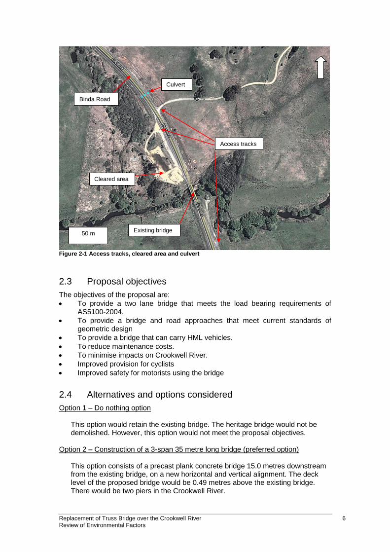
The approach roads to the bridge are two-lane roads that narrow to one lane immediately before the bridge. Traffic coming from the north must yield to traffic from the south. This is indicated by ‘yield’ signs on either side of the road from the southbound approach. Signs on both approaches to the bridge indicate that the road narrows ahead. There is an access road to a residence about 135 metres north of the existing bridge on the eastern side of Binda Road. There is also an access track about 85 metres north of the existing bridge that leads to a cleared area on the north western side of the existing bridge. A stormwater culvert runs under Binda Road about 185 metres north of the bridge. An access track leading to the southern abutment of the timber truss bridge is located to the south east of the existing bridge, starting 170 metres south of the bridge. James Park Road intersection is located around 380 metres to the south of the bridge. The access tracks, cleared area and culvert are shown on Figure 2-1.
Replacement of Truss Bridge over the Crookwell River 6 Review of Environmental Factors
Binda Road
50 m
Culvert
Cleared area
Access tracks
Existing bridge
Figure 2-1 Access tracks, cleared area and culvert
2.3 Proposal objectives
The objectives of the proposal are:
To provide a two lane bridge that meets the load bearing requirements of AS5100-2004.
To provide a bridge and road approaches that meet current standards of geometric design
To provide a bridge that can carry HML vehicles.
To reduce maintenance costs.
To minimise impacts on Crookwell River.
Improved provision for cyclists
Improved safety for motorists using the bridge
2.4 Alternatives and options considered
Option 1 – Do nothing option This option would retain the existing bridge. The heritage bridge would not be
demolished. However, this option would not meet the proposal objectives. Option 2 – Construction of a 3-span 35 metre long bridge (preferred option)
This option consists of a precast plank concrete bridge 15.0 metres downstream from the existing bridge, on a new horizontal and vertical alignment. The deck level of the proposed bridge would be 0.49 metres above the existing bridge. There would be two piers in the Crookwell River.
Replacement of Truss Bridge over the Crookwell River 7 Review of Environmental Factors
This new structure would provide wider traffic lanes, upgraded road approaches and improve safety. The earth fill works of this option were assessed to be the lesser compared to the remainder of the options.
Option 3 – Construction of a 2-span 35 metre long bridge
This option consists of a precast I-girder superstructure on a new horizontal alignment. The proposed bridge would be constructed 15 metres downstream from the existing bridge under a new vertical alignment. The deck level of the bridge would be 1.37 metres above the existing bridge deck level. There would be one pier in the Crookwell River. The amount of earth fill works were assessed to be larger compared to Option 2 and the bridge pier would be located in the middle of the river.
Option 4 – Construction of a single span bridge
This option would have a single span Super-T bridge along a new horizontal alignment. The new bridge would be located 15 metres downstream from the bridge, under new vertical alignment. The deck level of the proposed bridge would be 1.82 metres above the existing bridge deck level. The amount of earth fill in this option is larger than Options 2 and 3.
Option 5 – Construction of a new bridge 15 metres upstream from the centre line of
the existing timber truss bridge
This option was assessed to be the most expensive option compared to Options 2, 3 and 4 downstream given the required bridge length would be longer and the alignment would be skewed to the river flow. This upstream option would shift the eastern road approach closer to the river bank. This section of the river is subject to severe erosion.
Option 6 – Construction of a new bridge on the exiting alignment
This option is not feasible because it would not allow for staged construction and would result in complete road closure for the duration of the works. This would result in a 29 kilometre detour and have major traffic impacts that are not justifiable.
2.4.1 Methodology for selection of preferred option
The options were assessed using the following criteria:
The preferred option should meet the objective of the proposal.
The preferred option should minimise environmental impacts.
The preferred option should provide a cost effective solution.
The preferred option should be constructible.
The location of the proposed bridge was the determining factor for the location
of the proposed road approaches alignment. Therefore, only the bridge options
are discussed.
Replacement of Truss Bridge over the Crookwell River 8 Review of Environmental Factors
2.4.2 Analysis of options
Option 1 would not meet the objectives of the proposal. Option 6 would require a complete road closure and was not considered in more detail. All remaining options would require works that have the potential to impact the Crookwell River. A single span bridge (Option 4 or single span Option 5) would have the least impact on the Crookwell River because piling in the river bed would not be required. However, the construction of a single span bridge would require significantly more fill than any of the other options and would have the potential to impact the Crookwell River given its proximity to the river bank. The bridge under Option 4 would also be longer than any other option. This would result in high construction costs. Impacts to the river would be similar for options 2 and 3 as they both would require piling within the waterway. However, Option 2 would require less fill than the other options, including option 3. This would reduce the constructability costs of these options.
2.5 Preferred option
Option 2 is the preferred option. Option 2 would have the potential to cause some impacts to Crookwell River but would require less fill, be easier to construct and provide a cost effective option for meeting the proposal objectives. Impacts to the Crookwell River can be avoided or minimised through implementation of standard environmental safeguards commonly used in the construction industry.
Replacement of Truss Bridge over the Crookwell River 9 Review of Environmental Factors
3 Description of the proposal
This chapter describes the proposal and provides descriptions of existing conditions, the design parameters including major design features, the construction method and associated infrastructure and activities.
3.1 The proposal
The proposal comprises demolition and replacement of the timber truss bridge over the Crookwell River and about 700 metres of road works on the approaches to the replacement bridge. A concept design is provided in Appendix B. The general features of the proposal are:
Construction of a new concrete bridge along a modified alignment to the west of the existing timber truss bridge. The proposed bridge would be 12.12 metres wide and would include 3 spans within an overall length of 39.37 metres. Two piers supported on cast in place bored piles would be constructed within the creek bed.
Construction of road approaches to the new bridge. The existing approach roads would be removed to allow for the construction of the eastern batters of the new road alignment.
Replace the existing culvert and headwalls under Binda Road.
Upgrade to existing access to a private residence north of the bridge
Relocation of electricity line and three poles to the west of the proposed road approaches.
Adjustment to the location of a Telstra cable under Binda Road.
Demolition of the existing timber truss bridge.
Scour remediation works to stop ongoing erosion of river bank to the southeast of the existing timber truss bridge and southwest of the proposed bridge.
Removal of a build-up of sediment to the west of the proposed bridge.
Ancillary facilities include three compound sites.
3.2 Design
3.2.1 Design criteria
The concept design is provided in Appendix B.
Bridge The bridge would be designed and constructed to meet the requirements of AS5100-2004 and relevant Australian Standards.
The bridge superstructure comprises of 3 spans along a 39.37 metre long deck with a carriageway consisting of two 3.5 metre wide lanes and 2.0 metre wide shoulders and high performance barriers on each side of the bridge. The deck would be constructed of 535mm deep prestressed concrete spaced planks composite with a cast-in-place reinforced concrete deck slab and an asphalt wearing course over a waterproof membrane layer. The deck would have a 3% grade to each side from the centre line and be above the 100 year flood level. The bridge substructure would comprise spill through abutments with sill beams and cantilevered wing walls supported on bored cast-in-situ reinforced concrete piles with permanent steel casing. The bridge abutments would comprise three 900mm dia
Replacement of Truss Bridge over the Crookwell River 10 Review of Environmental Factors
piles each. The piers comprise pile trestles with cast-in-place reinforced concrete piles with permanent casing below the existing creek bed level. Bridge piers would comprise two 1050mm diameter piles each. Road approaches The approach roads would have two 3.5 metre lanes. The pavement would be:
14/7 double double seal.
150 millimetres of DGB20
150 millimetres of DGS
300 millimetres of select material with a minimum CBR of 15%
Subgrade with a minimum CBR of 4% Scour protection The scour protection south east of the existing bridge and the scour protection on the south west side would require installation of geofabric material on the scoured area. Drainage blanket quality rock (0.5 metre – 1 metre) would be installed in the river bed. Drainage blanket quality rock (150 millimetres – 250 millimetres) would be installed on top of the larger rock. The scour protection south east of the existing bridge would be about 12 metres wide, about 3.5 metres deep and about 4.5 metres high. The scour protection on the south west side of the existing bridge would be about nine metres wide, about five metres deep and about six metres high. Cross-sections of the bridge, approach roads and scour protection works south east of the bridge are provided in Appendix B.
3.2.2 Engineering constraints
The main engineering constraint would be:
Providing access for equipment to a waterway.
The relocated electricity line would cross the compound site on the north west side of the bridge. This may limit the type of plant that can be used in this area.
3.3 Construction activities
3.3.1 Work methodology
Site establishment and installation of traffic controls
Installation of traffic controls in accordance with the Traffic Management Plan and Traffic Control Plans prepared for the works (refer to section 3.3.6).
New road reserve boundary fencing would be installed along new property boundary.
Installation of erosion and sediment controls in accordance with the Erosion and Sediment Control Plans and environmental specifications prepared for the project.
Establishment of three compound sites (refer to section 3.4 and Figure 3-1).
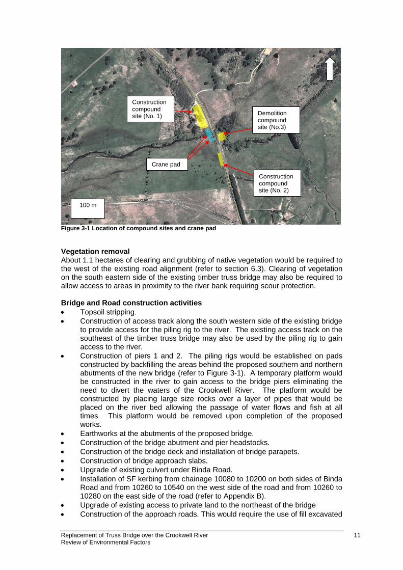
Replacement of Truss Bridge over the Crookwell River 11 Review of Environmental Factors
Crane pad
Construction compound site (No. 2)
100 m
Construction compound site (No. 1) Demolition
compound site (No.3)
Figure 3-1 Location of compound sites and crane pad
Vegetation removal About 1.1 hectares of clearing and grubbing of native vegetation would be required to the west of the existing road alignment (refer to section 6.3). Clearing of vegetation on the south eastern side of the existing timber truss bridge may also be required to allow access to areas in proximity to the river bank requiring scour protection. Bridge and Road construction activities
Topsoil stripping.
Construction of access track along the south western side of the existing bridge to provide access for the piling rig to the river. The existing access track on the southeast of the timber truss bridge may also be used by the piling rig to gain access to the river.
Construction of piers 1 and 2. The piling rigs would be established on pads constructed by backfilling the areas behind the proposed southern and northern abutments of the new bridge (refer to Figure 3-1). A temporary platform would be constructed in the river to gain access to the bridge piers eliminating the need to divert the waters of the Crookwell River. The platform would be constructed by placing large size rocks over a layer of pipes that would be placed on the river bed allowing the passage of water flows and fish at all times. This platform would be removed upon completion of the proposed works.
Earthworks at the abutments of the proposed bridge.
Construction of the bridge abutment and pier headstocks.
Construction of the bridge deck and installation of bridge parapets.
Construction of bridge approach slabs.
Upgrade of existing culvert under Binda Road.
Installation of SF kerbing from chainage 10080 to 10200 on both sides of Binda Road and from 10260 to 10540 on the west side of the road and from 10260 to 10280 on the east side of the road (refer to Appendix B).
Upgrade of existing access to private land to the northeast of the bridge
Construction of the approach roads. This would require the use of fill excavated
Replacement of Truss Bridge over the Crookwell River 12 Review of Environmental Factors
from the site and imported fill.
Installation of safety barriers on road approaches – about 255 metres on north western side of Binda Road, about 120 metres on the north eastern side of Binda Road, about 130 metres on the south eastern side of Binda Road and about 120 metres on the south western side of Binda Road.
Asphalt works on the approach roads and bridge deck and slab.
Installation of line marking on new approach roads and bridge.
Relocation of directional signs. Drainage The drainage design is provided in Appendix B. The main drainage elements are:
Replacement of the culvert and headwall under Binda Road about 180 metres from the existing bridge.
Construction of three diversion drains beside Binda Road south of the existing bridge – about 105 metres on south eastern side of Binda Road, about 45 m and about 140 metres on the south western side of Binda Road.
Construction of two diversion drains beside Binda Road north of the existing bridge – about 60 metres on the north western side on Binda Road and about 110 metres on the north eastern side of Binda Road.
Installation of sub surface drainage along various sections of the proposed road. Sub surface drainage outlets would be installed to transfer stormwater from the sub surface drains to existing drains or to the new diversion drains.
Installation of outlet treatment at four diversion drains draining to the Crookwell River.
Demolition of the truss bridge The demolition of the bridge would involve the management of steel and timber bridge parts with lead paint. This is discussed below. The demolition works would comprise the following:
Installation of erosion and sediment controls including controls specific to the management of lead in accordance with RMS Safety Specifications.
The bottom chords would be propped up from the ground using temporary scaffolding and beams placed on timber pads and the temporary rock platform constructed prior to the bridge piling works as described in section 3.3.1 above.
The bridge would be removed by crane. Crane access to the timber truss bridge would be gained from behind the bridge abutments and from the existing access track to the southeast of the timber truss bridge.
The truss span would be demolished by removing its individual components, e.g. top chord, diagonals, verticals, bottom chords, etc. The bridge deck would be demolished by removing the bitumen layer, the timber decking and the diagonals followed by the removal of the steel girders.
The bridge abutments would be demolished by removing the timber trusses by crane and concrete/masonry by excavator. The removal of the bridge abutments may require some earthworks around the abutments (profiling). Upon the removal of the bridge abutments the river bank would be stabilised using gabion rock mattress or other erosion control works.
Bridge parts would be stored in the compound before being recycled or disposed of at an appropriately licensed waste facility. The demolition works would be undertaken in accordance with RMS Specification B341 Demolition of Existing Structure. The disposal of waste material would be in accordance with the requirements of RMS Specification G36 Environmental Protection Management System, Section 6.11
Replacement of Truss Bridge over the Crookwell River 13 Review of Environmental Factors
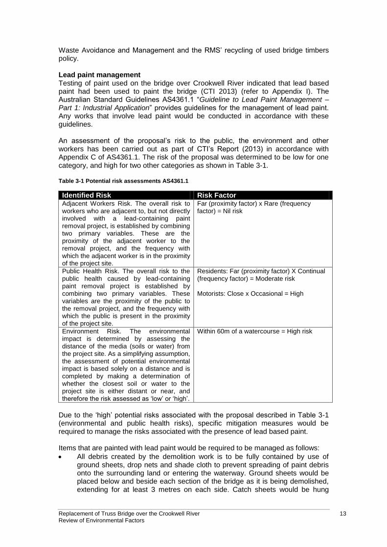
Waste Avoidance and Management and the RMS’ recycling of used bridge timbers policy. Lead paint management Testing of paint used on the bridge over Crookwell River indicated that lead based paint had been used to paint the bridge (CTI 2013) (refer to Appendix I). The Australian Standard Guidelines AS4361.1 “Guideline to Lead Paint Management – Part 1: Industrial Application” provides guidelines for the management of lead paint. Any works that involve lead paint would be conducted in accordance with these guidelines. An assessment of the proposal’s risk to the public, the environment and other workers has been carried out as part of CTI’s Report (2013) in accordance with Appendix C of AS4361.1. The risk of the proposal was determined to be low for one category, and high for two other categories as shown in Table 3-1. Table 3-1 Potential risk assessments AS4361.1
Identified Risk Risk Factor Adjacent Workers Risk. The overall risk to workers who are adjacent to, but not directly involved with a lead-containing paint removal project, is established by combining two primary variables. These are the proximity of the adjacent worker to the removal project, and the frequency with which the adjacent worker is in the proximity of the project site.
Far (proximity factor) x Rare (frequency factor) = Nil risk
Public Health Risk. The overall risk to the public health caused by lead-containing paint removal project is established by combining two primary variables. These variables are the proximity of the public to the removal project, and the frequency with which the public is present in the proximity of the project site.
Residents: Far (proximity factor) X Continual (frequency factor) = Moderate risk Motorists: Close x Occasional = High
Environment Risk. The environmental impact is determined by assessing the distance of the media (soils or water) from the project site. As a simplifying assumption, the assessment of potential environmental impact is based solely on a distance and is completed by making a determination of whether the closest soil or water to the project site is either distant or near, and therefore the risk assessed as ‘low’ or ‘high’.
Within 60m of a watercourse = High risk
Due to the ‘high’ potential risks associated with the proposal described in Table 3-1 (environmental and public health risks), specific mitigation measures would be required to manage the risks associated with the presence of lead based paint. Items that are painted with lead paint would be required to be managed as follows:
All debris created by the demolition work is to be fully contained by use of ground sheets, drop nets and shade cloth to prevent spreading of paint debris onto the surrounding land or entering the waterway. Ground sheets would be placed below and beside each section of the bridge as it is being demolished, extending for at least 3 metres on each side. Catch sheets would be hung
Replacement of Truss Bridge over the Crookwell River 14 Review of Environmental Factors
below the bridge, or a fully scaffolded platform erected with impervious covers, where the bridge crosses over the water.
Remove paint from "cut zones" by use of chemical stripper or vacuum-shrouded power tools.
Spray remaining paint with PVA to encapsulate flaking paint.
Remove the timber or steel member(s) from the structure and place on plastic sheeting.
Wrap in plastic for transportation.
Contaminated containment materials would be disposed of at the end of the project.
Scour protection works The scour protection works area, south east of the existing bridge, would be accessed from the existing access track off Binda Road. It is proposed that these works be undertaken from the top of the bank, i.e. from the access track. The scour protection area would be about 12 metres wide, about 3.5 metres deep and about 4.5 metres high. The scour protection area on the south west side of the existing bridge would be accessed from the temporary construction access track and crane pad on the south west side of the bridge (refer to Figure 3-1). These works would be undertaken from the top of the bank. The scour protection area would be about nine metres wide, about five metres deep and about six metres high. Environmental controls including silt booms would be installed prior to commencing the rehabilitation works. Geofabric material would be laid from the top of the bank down the slope to cover the entire area requiring rehabilitation. Large drainage blanket quality rock would be placed at the toe of the bank using an excavator. Drainage blanket quality rock of smaller size would be placed to form a 1.5 to 1 batter. Sediment and vegetation that has built up in the creek bed west of the proposed bridge would be removed. Temporary erosion and sediment controls would be removed upon completion of the scour rehabilitation works. Post construction works The river banks and all areas that have been disturbed by the works would be remediated in accordance with the requirements of RMS Quality Specifications. All temporary structures would be removed.
3.3.2 Construction hours and duration
The construction works are estimated to have duration of 12 months including weather contingency. The works are expected to start in mid 2013. Construction would be undertaken during standard working hours: Standard hours: Monday to Friday – 7:00 am to 6:00 pm Saturday – 8:00 am to 1:00 pm Sundays and Public Holidays - No work
Replacement of Truss Bridge over the Crookwell River 15 Review of Environmental Factors
There is potential for asphalt works and traffic switching work to be undertaken outside these hours. If work outside standard hours is required then they would be undertaken in accordance with RMS’s Environmental Noise Management Manual (RTA, 2001).
3.3.3 Plant and equipment
The following is a list of the equipment and machinery that may be used during the project (other equipment may also be required):
Excavators.
Compactors.
Earthwork equipment.
Concrete trucks.
Piling Rig.
Concrete boom pump.
Hot works equipment.
Scaffolding and formwork.
Crane (300T).
Asphalting machines.
Graders.
Smooth drum rollers.
Vibrating (pad foot) rollers.
Vibrating plates.
Line marking equipment.
Franna crane.
Chainsaw.
Delivery trucks.
Front end loaders.
Water carts.
Chain saws.
Concrete supply agitator.
Bobcat.
Backhoe.
Stabilisers.
Concrete vibrators.
3.3.4 Earthworks
Earthworks would be required to construct the approaches to the bridge along the new road alignment. Topsoil would be stripped until a solid foundation is reached. This soil would be stockpiled and reused on site where possible. Road base material would be imported and used in the construction of the new road alignment. Excavating and backfilling would be required during the demolition of the existing timber truss bridge and construction of the new bridge. The estimated cut and fill quantities for the works are: Cut: 2,797 m3
Replacement of Truss Bridge over the Crookwell River 16 Review of Environmental Factors
Fill: 7,412 m3
3.3.5 Source and quantity of materials
RMS estimated that the following quantities would be required for the proposed works:
Material Volume
Unbound and modified pavement course
2,118 m3
Pavement stabilisation 2,505 m3
Precoated aggregate 154 m3
Guide posts 11
Safety barriers 636 m
Imported fill 4,615 m3
3.3.6 Traffic management and access
A Traffic Management Plan and Traffic Control Plans would be prepared for the works. The existing timber truss bridge would remain in use during the construction of the new bridge. Two-way traffic along MR54 Binda Road would be retained. Traffic would be switched from the old alignment to the new road alignment once the construction of the new bridge has been completed. Access to a private property may be temporarily affected during the construction of the northern approach to the new bridge and upgrade works at this access location. However access to the private property would be maintained at all times.
3.4 Ancillary facilities
Three compound sites and would be established (refer Figure 3-1) as follows: Compound Site No. 1 – Northwest of the new bridge A compound site to the north west of the works would be the main compound during the construction of the new bridge and approach roads. The compound site at the north west of the bridge would contain parking, site office, toilets and fuel/chemical storage facilities. Compound Site No. 2 – Southwest of the new bridge A second compound site would be located on the western side of Binda Road, near the southern end of the works. This compound site would comprise of a small shed that would be used mainly for material storage purposes. Compound site No. 3 – Southeast of existing timber truss bridge Following the construction of the new bridge the main compound would move to the south eastern side of the existing bridge. This compound would be used during the demolition of the existing timber truss bridge. Compound sites No. 1 and No. 2 are located on private property (refer to section 3.6).
Replacement of Truss Bridge over the Crookwell River 17 Review of Environmental Factors
3.5 Public utility adjustment
The works would require the relocation of an overhead electricity line and an underground Telstra cable. Telstra cable A Telstra cable currently running under Binda Road, north of the bridge will require relocation. The relocation of this service would take place during the construction of the northern approach to the new bridge. Electricity line An overhead electricity line currently running within private land along the western side of the existing timber truss bridge requires relocation to allow for the construction of the new road alignment. About 470 metres of electricity line and three poles would be relocated to the west of the proposed bridge and road. The new line would be located on Crown Land and on private property. A 15 metre easement would be create for the proposed electricity line. The relocation work would take place prior to the construction works commencing.
3.6 Property acquisition
RMS would be required to acquire property along the length of the proposed works, to the west and east of Binda Road, north and south of the existing timber truss bridge. RMS would acquire the land in accordance with the Land Acquisition (Just Terms Compensation) Act 1991 and the RMS Land acquisition information guide 2012. The land to be acquired includes Crown Land and land in private ownership. A plan showing the land to be acquired is provided in Appendix B. The properties where the land would be acquired are:
Lot 1 DP1040427 (Private Land on the south western side of the bridge and a
small area of land on the north western side of the bridge). Partial acquisition
of the lot. The area to be acquired would be 5736.4 square metres.
Lot 7306 DP 1140304 (Crown Land on the north western side of the bridge).
Partial acquisition of the lot. The area to be acquired would be 7176.3 square
metres.
Lot 7307 DP 1140304 (Crown Land on the north eastern side of the bridge).
Partial acquisition of the lot. The area to be acquired would be 571 square
metres.
Replacement of Truss Bridge over the Crookwell River 18 Review of Environmental Factors
4 Statutory and planning framework
This chapter describes the statutory planning context of the proposal and considers the relevant provisions of Part 5 of the Environmental Planning and Assessment Act 1979 (EP&A Act). The chapter also discusses relevant Environmental Planning Instruments (EPI) and other relevant legislation.
4.1 State Environmental Planning Policies
4.1.1 State Environmental Planning Policy (Infrastructure) 2007
State Environmental Planning Policy (Infrastructure) 2007 (ISEPP) aims to facilitate the effective delivery of infrastructure across the State. Clause 94 of ISEPP permits development on any land for the purpose of a road or road infrastructure facilities to be carried out by or on behalf of a public authority without consent. As the proposal is for demolition of a timber truss bridge, construction of a replacement bridge and road works on the approach roads to the bridge and is to be carried out by Roads and Maritime Services, it can be assessed under Part 5 of the Environmental Planning and Assessment Act 1979. Development consent from council is not required. The proposal is not located on land reserved under the National Parks and Wildlife Act 1974 and does not affect land or development regulated by State Environmental Planning Policy No. 14 - Coastal Wetlands, State Environmental Planning Policy No. 26 - Littoral Rainforests, State Environmental Planning Policy (State and Regional Development) 2011 or State Environmental Planning Policy (Transitional Major Projects) 2005. Part 2 of the ISEPP contains provisions for public authorities to consult with local councils and other public authorities prior to the commencement of certain types of development. Consultation, including consultation as required by ISEPP (where applicable), is discussed in chapter 5 of this REF.
4.1.2 State Environmental Planning Policy 44 – Koala Habitat Protection
The SEPP 44 encourages the conservation and management of natural vegetation areas that provide habitat for Koalas to ensure that permanent free living populations will be maintained over their present range. RMS is a public authority and is not bound by this SEPP. However, RMS has taken the aims of the SEPP into consideration. The SEPP 44 aims to identify areas of potential and core Koala Habitat. These are described as follows:
Core Koala Habitat is defined as an area of land with a resident population
of Koalas, evidenced by attributes such as breeding females, and recent
and historical records of a population.
Potential Koala Habitat is defined as areas of native vegetation where the
trees listed in Schedule 2 of SEPP 44 constitute at least 15% of the total
number of trees in the upper or lower strata of the tree component.
Replacement of Truss Bridge over the Crookwell River 19 Review of Environmental Factors
Crookwell LGA is listed on Schedule 1 of SEPP 44, therefore the field surveys considered the presence of core and potential koala habitat at the site. No koalas or koala feed trees were found during the survey. The site does not constitute potential or core koala habitat (refer to section 6.3).
4.2 Local Environmental Plans
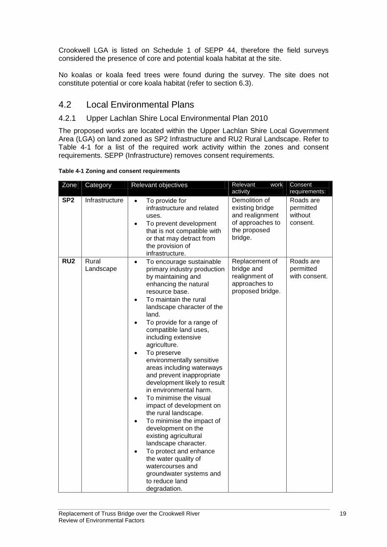
4.2.1 Upper Lachlan Shire Local Environmental Plan 2010
The proposed works are located within the Upper Lachlan Shire Local Government Area (LGA) on land zoned as SP2 Infrastructure and RU2 Rural Landscape. Refer to Table 4-1 for a list of the required work activity within the zones and consent requirements. SEPP (Infrastructure) removes consent requirements. Table 4-1 Zoning and consent requirements
Zone Category Relevant objectives Relevant work activity
Consent requirements:
SP2 Infrastructure To provide for infrastructure and related uses.
To prevent development that is not compatible with or that may detract from the provision of infrastructure.
Demolition of existing bridge and realignment of approaches to the proposed bridge.
Roads are permitted without consent.
RU2 Rural Landscape
To encourage sustainable primary industry production by maintaining and enhancing the natural resource base.
To maintain the rural landscape character of the land.
To provide for a range of compatible land uses, including extensive agriculture.
To preserve environmentally sensitive areas including waterways and prevent inappropriate development likely to result in environmental harm.
To minimise the visual impact of development on the rural landscape.
To minimise the impact of development on the existing agricultural landscape character.
To protect and enhance the water quality of watercourses and groundwater systems and to reduce land degradation.
Replacement of bridge and realignment of approaches to proposed bridge.
Roads are permitted with consent.
Replacement of Truss Bridge over the Crookwell River 20 Review of Environmental Factors
Zone Category Relevant objectives Relevant work activity
Consent requirements:
To maintain areas of high conservation value vegetation.
Section 2.7 Demolition of a work requires development consent. However, the Infrastructure SEPP removes the requirement for consent. Section 5.10 Development consent is required for the demolition of any heritage item. However, the Infrastructure SEPP removes the requirement for consent. Impact from the proposal on the heritage listed bridge are considered in section 6.2.
4.3 Other relevant legislation
4.3.1 Threatened Species Conservation Act 1995 (TSC Act)
The Threatened Species Conservation Act 1995 aims to conserve and protect certain classes of threatened, endangered and vulnerable species, populations and ecological communities.
Section 5A of the EPA&A Act lists a number of factors to be taken into account when deciding if there is the likelihood of a significant impact on threatened species, populations and their habitat or on ecological communities. If there is a chance of an impact, then an Assessment of Significance would be required to determine the significance of the impact. If there is likelihood for a significant impact on threatened species, populations and their habitat or on ecological communities then a Species Impact Assessment is required. The Assessment of Significance concluded that the proposal is not likely to significantly affect the threatened fauna species considered likely to occur in the study area, either directly or indirectly, provided the recommended safeguards are carried out. Therefore, a Species Impact Statement is not required. More information about threatened species is available in Section 6.3 the background searches and the habitat assessment in Appendix D.
4.3.2 Fisheries Management Act 1994 (FM Act)
The provisions of the Fisheries Management Act 1994 relating to the development approval process operate similarly to the above TSC Act. The Act identifies threatened aquatic species, populations and ecological communities and requires an identical test of significance. Activities that trigger the requirement for Roads and Maritime Services to notify the Minister for Fisheries are as follows:
Dredging or reclamation of waterways, including removal of snags or
aquatic vegetation (28 days notification) (sections 198 and 199).
Temporary or permanent blockage of fish passage requires a permit under
section 219.
Piling in the creek bed falls under the definition of dredging and reclamation. RMS is required, under clause 199 of the FM Act, to consult with DPI (Fisheries). Refer to
Replacement of Truss Bridge over the Crookwell River 21 Review of Environmental Factors
Section 5 for further information.
4.3.3 Water Management Act 2000 (WM Act)
Under the WM Act a controlled activity approval is required from the NSW Office of Water for certain types of developments and activities that are carried out in or near a river, lake or estuary. Under the WM Act a controlled activity means:
(a) The erection of a building or the carrying out of a work (within the meaning of the Environmental Planning and Assessment Act 1979), or (b) The removal of material (whether or not extractive material) or vegetation from land, whether by way of excavation or otherwise, or (c) The deposition of material (whether or not extractive material) on land, whether by way of landfill operations or otherwise, or (d) The carrying out of any other activity that affects the quantity or flow of water in a water source.
This approval must be sought prior to the commencement of works; however, public authorities are exempt from the requirements to obtain a controlled activity approval under Clause 39A of the Water Management (General) Regulation 2004. RMS is a public authority and is therefore exempt from the requirements.
4.3.4 Heritage Act 1977
The NSW Heritage Act 1977 is a statutory tool designed to conserve the cultural heritage of NSW and used to regulate development impacts on the state’s heritage assets. Administered by the NSW Heritage Office, the Act details the statutory requirements for protecting historic buildings and places and includes any place, building, work, relic, movable object, which may be of historic, scientific, cultural, social, archaeological, natural or aesthetic value. When items are listed on the State Heritage Register (SHR) applications to carry out works on those items need to be made to the Heritage Council under Section 60 of the Act. A search of the study area and surrounds indicated that no items in the vicinity of Crookwell River Bridge are included on the SHR; therefore no Section 60 applications are required. State agencies and authorities in NSW are required to keep a register of heritage places under their management under Section 170 of the Act. The s.170 registers are also held in the NSW Heritage Branch’s State Heritage Inventory (SHI), an electronic database of statutory listed heritage items in NSW. Crookwell River Bridge is listed on the RMS Heritage and Conservation Register under s.170 of the Act. It is a statutory requirement under s.170 that a delisting process with the NSW Heritage Branch (OEH) be undertaken when demolishing items listed on an s.170 register. The demolition would therefore need to be assessed by the Heritage Branch.
4.4 Commonwealth legislation
4.4.1 Environment Protection and Biodiversity Conservation Act 1999
Under the Environment Protection and Biodiversity Conservation Act 1999 (EPBC Act) a referral is required to the Australian Government for proposed ‘actions that have the potential to significantly impact on matters of national environmental significance or the environment of Commonwealth land. These are considered in Appendix A and chapter 6 of the REF.
Replacement of Truss Bridge over the Crookwell River 22 Review of Environmental Factors
The assessment of the proposal’s impact on matters of national environmental significance and the environment of Commonwealth land found that there is unlikely to be a significant impact on relevant matters of national environmental significance. Accordingly, the proposal has not been referred to the Australian Government Department of Sustainability, Environment, Water, Population and Communities.
4.5 Confirmation of statutory position
RMS is the proponent and determining authority for the proposed works. By adopting the requirements of the State Environmental Planning Policy (Infrastructure) 2007, the proposed works may be carried out without the need for development consent from the Upper Lachlan Shire Council. The proposal is subject to an environmental impact assessment under Part 5 of the Environmental Planning and Assessment Act 1979.
Replacement of Truss Bridge over the Crookwell River 23 Review of Environmental Factors
5 Stakeholder and community consultation
This chapter discusses the consultation undertaken to date with the community, relevant government agencies, Aboriginal community and other stakeholders. It also outlines the consultation proposed for the future.
5.1 Consultation strategy
RMS developed a communications plan in accordance with the RMS Community Involvement Practice Notes and Resources Manual, which identified activities for the consultation process involving RMS, other relevant government agencies, organisations, community representatives and residents. The overarching strategy was to inform key stakeholders, immediate residents and businesses, road users and the broader community of the plan to replace the existing Crookwell Timber Truss Bridge. A number of communication tools outlined in the section below were used to inform the community. Objectives of the plan were:
To provide factual information to the public and key stakeholders about the proposal.
To clearly outline the opportunities to provide feedback and how it will be incorporated.
To gather feedback, local knowledge, and important information that will shape development of the proposal.
To be open and transparent about the work that RMS are doing.
To build and sustain relationships with key stakeholders.
5.2 Community involvement
A community update newsletter (refer to Appendix C) was letter box dropped to Crookwell residents in mid February 2013. The newsletter provided project information, background, location maps and invited the community to comment on the proposed replacement of the Crookwell Timber Truss Bridge. A dedicated Crookwell Bridge webpage was created on the RMS project website and contained project information, maps, and photographs. A media release was distributed to local media on 14 February 2013 also inviting the community to comment on the proposed replacement. The community was given the opportunity to comment from 13 February to 27 February 2013. No submissions or comments were received from the community during the comment period. Several phone calls were made to key stakeholders including Upper Lachlan Shire Council and impacted landowners to gather community feedback on the project. A number of comments and issues were raised during the phone discussions. Safety and access One stakeholder raised safety concerns regarding access to their property when travelling southbound. The road has a 100 km/hr speed limit and the left hand turn into their property could be dangerous if other traffic do not slow down behind them. The stakeholder often has a trailer on their vehicle which also makes it difficult to turn
Replacement of Truss Bridge over the Crookwell River 24 Review of Environmental Factors
into the driveway. The driveway location is outside the project area and is outside the project scope. This issue has been referred to a RMS Road Safety and Traffic Officer who is now investigating this issue. Impact of proposal on property boundary One stakeholder raised concerns about where the new property boundary would be placed and the impact it could have on trees within their property. They were also concerned about the potential location of power poles on their land. RMS proposes to place a stretch of fence on the outside of these trees in the road reserve to avoid damage or loss of the trees. This addition does not impact the road safety or long term maintenance of the road or bridge. The Community Issues Report is provided in Appendix C. The report is also available on the RMS website.
5.3 Aboriginal community involvement
A Native Title search was conducted on 7 December 2012 by RMS, which indicated that there was a Native Title claim by Gundungurra Tribal Council Aboriginal Corporation (GTCAC) active within the study area. The study area is within the boundary of Pejar Local Aboriginal Land Council (PLALC). Aboriginal consultation was carried out in accordance with Stage 2 of the RMS Procedure for Aboriginal cultural heritage consultation and investigation (PACHCI). Representatives from PLALC and GTCAC were contacted by the RMS Aboriginal Cultural Heritage Advisor and were invited to participate in the Stage 2 PACHCI survey. A representative from PLALC attended the site survey. Representatives from GTCAC were booked in for the site survey but did not attend on the day. PLALC has provided a site survey report which has been incorporated in the Aboriginal Heritage Assessment Report as an appendix. A copy of the final Aboriginal Heritage Assessment Report has been forwarded to PLALC and GTCAC for their information. No Aboriginal consultation under Stage 3 PACHCI is required by RMS. Refer to Section 6.8 and Appendix H for an assessment of the potential impacts to Aboriginal heritage.
5.4 ISEPP consultation
Clause 14 of the ISEPP requires that consultation with local council must occur when a development has the potential to impact on a local heritage item when this impact is likely to not be minor or inconsequential to the local heritage item. Crookwell River Bridge is considered to be a heritage item of local significance under Schedule 5 of the Upper Lachlan Shire LEP. Under Clause 14 the public authority undertaking the development must assess the impact on the item, provide the local council with written notice to carry out the development with a copy of the Statement of Heritage Impacts and consider any response to the notice received from the council regarding the proposal within 21 days of receiving the notice.
Replacement of Truss Bridge over the Crookwell River 25 Review of Environmental Factors
5.5 Government agency and stakeholder involvement
RMS would consult with the following government agencies:
NSW Heritage Branch – RMS would undertake a delisting process with the
Heritage Branch because it is a statutory requirement when demolishing
items listed on a section 170 register.
DPI (Fisheries) NSW – the piling and scour protection works in the river
bed would be classed as dredging and reclamation under clause 199 of
the Fisheries Management Act 1994. RMS is required to give notice of the
proposed works to NSW Fisheries and consider any comments received
within 28 days of the notice.
5.6 Ongoing or future consultation
RMS is currently undertaking consultation with local landowners about access, compound establishment and property acquisition.
The following ongoing consultation will also be undertaken:
Ongoing meetings with Upper Lachlan Shire Council, government agencies and other stakeholders as required.
Consultation with community stakeholders to assist in managing impacts during construction. This includes:
− Notifying residents when works will commence. − Notifying residents of night works.
Follow-up meetings to discuss access arrangements with directly affected landowners prior to construction impacts.
Replacement of Truss Bridge over the Crookwell River 26 Review of Environmental Factors
6 Environmental assessment
This section of the REF provides a detailed description of the potential environmental impacts associated with the construction and operation of the proposal. All aspects of the environment potentially impacted upon by the proposal are considered. This includes consideration of the factors specified in the guidelines Is an EIS required? (DUAP 1999) and Roads and Related Facilities (DUAP 1996) as required under clause 228(1)(b) of the Environmental Planning and Assessment Regulation 2000. The factors specified in clause 228(2) of the Environmental Planning and Assessment Regulation 2000 are also considered in Appendix A. Site-specific safeguards are provided to ameliorate the identified potential impacts.
6.1 Geology, soils and water
6.1.1 Existing environment
Geology The geology of the Crookwell subregion is dominated by fine grained Ordovician and Silurian sedimentary rocks, with some granites, while tertiary basalts with buried river gravels are located along ridges well above present streams. The underlying geology of the study area itself consists of Quarternary alluvial gravel, sand, silt and clay along the river, with the ‘Abercrombie Formation’ located on either side of Binda Road, to the north and south of the river. The ‘Abercrombie Formation’ consists of brown and buff to grey thinly to very thickly bedded fine- to coarse grained mica-quartz (+-feldspar) sandstone, interbedded with laminated siltstone and mudstone (RMS 2013). Soils The soils of the proposal site are described as red-brown earths, characterised by a layer of sandy loam to light clay loam overlying a clay subsoil (ASRIS, accessed 30/01/13). Geotechnical investigations found that soils at the northern abutment comprised fill and residual sandy clay of firm consistency below the fill. Soils at the southern bridge pier were found to be gravelly sand overlaying residual sandy clay. Soils at the southern abutment were found to be loose to very loose and soft clayey sand, gravelly sand and clay (RMS 2011). The proposed site and surrounding area is classed as having an extremely low probability for the occurrence of acid sulphate soils (ASRIS, accessed 7/03/13). SESL Australia carried out analysis on soil in the river bed and on the bank. The analysis found that the soil was considered to be non-aggressive to concrete and steel and have low salinity (SESL 2012) (refer to Appendix J). There are two areas in the vicinity of the bridge where the river bank is being scoured and bank erosion is occurring. There is a scoured area to the south east of the existing bridge (upstream) at a bend in the river and a scoured area to the south west of the existing bridge. Both areas are scoured during periods of high flow. Water The Crookwell River is part of the Lachlan Catchment within the Murray-Darling basin and managed by the Lachlan Catchment Management Authority. The Crookwell River is an arterial waterway in the upper reaches of the Lachlan Catchment. It drains

Replacement of Truss Bridge over the Crookwell River 27 Review of Environmental Factors
into Lake Wyangala (dammed) more than 50 kilometres downstream, north of the proposed works. The Crookwell River within the vicinity of the proposed works is around 30 metres wide and its form is highly variable. SESL Australia carried our analysis on a water sample from the Crookwell River at the existing bridge (refer to Appendix J). The purpose of the sampling was to assess the corrosion and scaling properties of the water. The assessment found that the water was slightly alkaline, with a pH of 7.7 and had electrical conductivity of 0.22 mS/cm. The water is considered to be non-aggressive to concrete and steel. No water quality monitoring data from the Lachlan Catchment Management Authority was available for the Crookwell River. However, water quality within the catchment would be impacted by agricultural activities and land clearing in the region. Contamination Testing by CTI Consultants found lead paint on the structure (CTI, 2012).
Generally, the paint on the steel items tested was found to contain a moderate to high level of lead. The only exception was the top surface of the bottom chord which is assumed to be due to previous maintenance painting activities. The truss span has a steel lower chord, with steel bracing posts and rods. The paint on most items was in very poor condition with significant flaking. There is also frequent spot corrosion, on bracing members and associated with the rivets on the lower chords. Pull-off adhesion testing showed the adhesion of the paint to be variable, with some areas low enough to be at risk of dislodging if handled roughly during demolition and transport. The paint on the timber items on the truss span contains a high amount of lead and the condition is generally poor on the outer surfaces. Paint flakes were visible on the ground near the ends of the bridge. While no testing has been undertaken, there is the potential for some contamination of soils in the area around the bridge.
6.1.2 Potential impacts
Construction Demolition of the bridge has the potential to dislodge lead paint form the bridge. The paint would land on the soil or in the Crookwell River causing soil and water contamination. The demolition would be undertaken using appropriate containment controls to avoid potential impacts (refer to section 3 for details of methodology). The proposal has the potential to destabilise the river banks due to the movement of construction machinery. This has the potential to result in sediment laden water entering the river and a rise in turbidity at the site and downstream. Risks would be higher during activities needed for the construction of the new bridge, demolition of the existing bridge and scour protection works. Earthworks would be required to construct the new bridge abutments and to construct the new road alignment. These works also have the potential to lead to sediment laden water entering the river and/or its unnamed drainage line running north of the river which would increase turbidity and downstream sedimentation. The proposed bridge would be a three span bridge and would require piling and the construction of bridge supports in the river bed. This has the potential to cause downstream sedimentation.
Replacement of Truss Bridge over the Crookwell River 28 Review of Environmental Factors
A four cell box culvert running under Binda Road, north of the existing bridge would be extended to run under the new approach road. The works on the culvert have the potential to release sediment to the existing stormwater channels. Concrete spills to the river during the pile construction would have the potential to raise the pH of the water in the area of the spill. The removal of vegetation has the potential to disturb soils and create an erosion hazard. Due to the limited number of vegetation to be removed, impacts are likely to be minor. The risk is higher where riparian vegetation would need to be removed. The proposed works have the potential to impact soil and water quality through accidental spills. This risk is increased at site compounds where vehicle, machinery and other equipment may be stored and which are relatively close to the river and its unnamed drainage line (within 10 metres). Contaminated runoff from accidental hydrocarbon or chemical spills could also impact water quality in the Crookwell River. Excavations and/or profiling of the abutments once the bridge has been removed has the potential to disturb contaminated soils should these be present on site. The removal of sediment from the river would have the potential to cause sedimentation of the river. If a catastrophic event were to occur such as the bridge collapsing during demolition there could be potential ramifications to water quality. The demolition of the bridge would be undertaken section by section with the bridge being supported by temporary beams and scaffolding. This would minimise any potential risk of collapse of the bridge. Operation The proposed bridge would have two pier supports in the river channel. The flow in the river could be altered in the area around the proposed bridge piles which could result in erosion and sedimentation. The proposal would provide scour protection to a section of the river bank, southeast of the existing bridge that has been scoured during periods of high flow. Scour protection would also be installed around the base of the new bridge abutments and immediately downstream of the southern abutment, where major scour of the bank has occurred and destabilised the area. This would have a positive impact on water quality by preventing the release of sedimentation from the scoured area. Although the proposed demolition activities may present a short term localised risk to water quality from accidental spills and turbidity, it is expected that there would be considerable long term benefits to the water quality of Crookwell River from the demolition of the bridge. The removal of the bridge would eliminate the need for future maintenance work and the on-going risks of pollution such as lead paint. Long term impacts to water quality are not anticipated as risks from the proposal are only limited to the timeframe of the demolition works.
6.1.3 Safeguards and management measures
Impact Environmental safeguards Responsibility Timing
Works within Environmental Work Method RMS and Pre-
Replacement of Truss Bridge over the Crookwell River 29 Review of Environmental Factors
Impact Environmental safeguards Responsibility Timing
the waterway Statements (EWMS) would
be prepared for high risk
activities within waterways
(bridge construction, bridge
demolition and scour
protection works). The
EWMS would include, but
not be limited to, the
following and be reviewed by
RMS's Local Environmental
Officer prior to
commencement of works:
Description of works/activities including machinery.
Outline of the sequence of the works/activities
An environmental risk assessment to determine potential risks to discrete work elements or activities likely to affect the environment.
A map indicating the locations of controls to be put in place.
Evaluation of methods to reduce environmental risks.
Mitigation measures to reduce environmental risks (including those listed in this assessment).
A process for assessing the performance of the implemented mitigation measures.
A process for resolving environmental issues and conflicts.
Emergency procedures for chemical spills and other potential emergency incidents.
A contingency plan would be prepared in the event of a collapse of the bridge during demolition.
Soil testing would be undertaken prior to and following completion of the demolition to determine if there has been any impacts. Appropriate remediation would be undertaken should significant differences be found.
The removal of lead contaminated structures would be conducted in accordance with the Australian Standard Guidelines AS4361.1 “Guideline to Lead Paint Management – Part 1: Industrial Application”.
Contractor construction
Replacement of Truss Bridge over the Crookwell River 30 Review of Environmental Factors
Impact Environmental safeguards Responsibility Timing
Erosion and sedimentation
An Erosion and Sedimentation Control Plan (ESCP) would be prepared and implemented.
Erosion and sediment controls would be maintained regularly until the proposed works are completed (including the removal of any built up soils and materials).
Only the minimal amount of vegetation would be removed for access. Where trees need to be removed, preference would be made to keep the root in place.
Access to the waterway would be via two access tracks, the existing disturbed area to the southeast of the bridge, and a new track to be created on the western side of the bridge. All other areas would be designated as no go zones to avoid disturbance of the banks.
During rehabilitation, stabilise the banks of the waterway through revegetation and/or armouring according to a landscape plans.
Contractor Pre-construction and construction
Degradation of waterway from spills
Spill kits are to be kept on all machinery with operators trained with how to use them.
Response to spills to be discussed during toolbox meetings.
All debris created by the demolition work is to be fully contained by use of drop nets and shade cloth to prevent spreading of paint debris entering the waterway.
All re-fuelling of vehicles and equipment would be undertaken in an impervious bunded area at the compound site. The location of the refuelling bund would be located 40 metres from the top of the bank of the Crookwell River and away from the unnamed tributary.
The refuelling of the crane and/or drilling rig which would be located in proximity of the bank would be undertaken in an impervious double bund.
In the event of a spill or paint contamination of the waterway, works would cease and an RMS Environmental Officer be contacted immediately. Any potential contamination of the waterway
Contractor Pre-construction and construction
Replacement of Truss Bridge over the Crookwell River 31 Review of Environmental Factors
Impact Environmental safeguards Responsibility Timing
would be reported to the EPA immediately.
The use of a silt curtain should be considered to minimise potential downstream impacts during construction of the new bridge, demolition of existing bridge and scour protection works. A risk assessment should be undertaken prior to use to ensure the use of the silt curtain would not cause more disturbance than the proposed construction activity. The silt curtain should be used in such a way as not to restrict fish passage.
Access Access would be via existing access tracks where possible to minimise potential erosion susceptibility. Access tracks would be overlaid with geofabric and road base material.
RMS and Contractor
Pre-construction and construction
6.2 Non-Aboriginal heritage
nghenvironmental prepared a Statement of Heritage Impact (SoHI) (ngh, 2013b). This section summarises the report provided in Appendix G.
6.2.1 Existing environment
Background research The following was reviewed to identify any listed or potential heritage items in the area:
Review of existing heritage assessments for the heritage item.
A review of the Timber Truss Bridge Conservation Strategy: Submissions
Report and Revised Conservation Strategy (RMS 2012b).
Searches of Commonwealth, national and state heritage databases. This
has included the Australian Heritage Database and the NSW Heritage
Branch State Heritage Register.
Search of the Upper Lachlan Shire Council Local Environmental Plan
(LEP) 2010.
Search of the RMS Section 170 Heritage and Conservation Register
(S170).
Review of all other relevant literature.
The timber truss bridge is listed as a local heritage item in the Upper Lachlan Shire LEP and is listed on the RMS section 170 Heritage and Conservation Register. The bridge is not listed on the Australian Heritage Database or the State Heritage Register (SHR). There are no items listed on the SHR in the vicinity of the proposal. Timber Truss Bridge Strategy The bridge at Crookwell North is to be replaced as part of the strategic document, the Timber Truss Road Bridges – a Strategic Approach to Conservation (the Strategy) (RMS 2012a), which was endorsed by the Heritage Council of NSW on 13 August
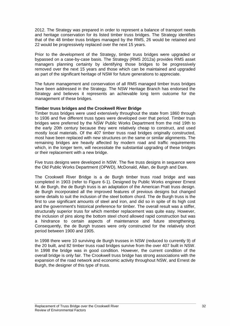
Replacement of Truss Bridge over the Crookwell River 32 Review of Environmental Factors
2012. The Strategy was prepared in order to represent a balance of transport needs and heritage conservation for its listed timber truss bridges. The Strategy identifies that of the 48 timber truss bridges managed by the RMS, 26 would be retained and 22 would be progressively replaced over the next 15 years. Prior to the development of the Strategy, timber truss bridges were upgraded or bypassed on a case-by-case basis. The Strategy (RMS 2012a) provides RMS asset managers planning certainty by identifying those bridges to be progressively removed over the next 15 years and those which can be maintained and upgraded as part of the significant heritage of NSW for future generations to appreciate. The future management and conservation of all RMS managed timber truss bridges have been addressed in the Strategy. The NSW Heritage Branch has endorsed the Strategy and believes it represents an achievable long term outcome for the management of these bridges. Timber truss bridges and the Crookwell River Bridge Timber truss bridges were used extensively throughout the state from 1860 through to 1936 and five different truss types were developed over that period. Timber truss bridges were preferred by the NSW Public Works Department from the mid 19th to the early 20th century because they were relatively cheap to construct, and used mostly local materials. Of the 407 timber truss road bridges originally constructed, most have been replaced with new structures on the same or similar alignments. The remaining bridges are heavily affected by modern road and traffic requirements which, in the longer term, will necessitate the substantial upgrading of these bridges or their replacement with a new bridge. Five truss designs were developed in NSW. The five truss designs in sequence were the Old Public Works Department (OPWD), McDonald, Allan, de Burgh and Dare. The Crookwell River Bridge is a de Burgh timber truss road bridge and was completed in 1903 (refer to Figure 6-1). Designed by Public Works engineer Ernest M. de Burgh, the de Burgh truss is an adaptation of the American Pratt truss design. de Burgh incorporated all the improved features of previous designs but changed some details to suit the inclusion of the steel bottom chord. The de Burgh truss is the first to use significant amounts of steel and iron, and did so in spite of its high cost and the government's historical preference for timber. The overall result was a stiffer, structurally superior truss for which member replacement was quite easy. However, the inclusion of pins along the bottom steel chord allowed rapid construction but was a hindrance to certain aspects of maintenance and future strengthening. Consequently, the de Burgh trusses were only constructed for the relatively short period between 1900 and 1905. In 1998 there were 10 surviving de Burgh trusses in NSW (reduced to currently 9) of the 20 built, and 82 timber truss road bridges survive from the over 407 built in NSW. In 1998 the bridge was in good condition. However, the current condition of the overall bridge is only fair. The Crookwell truss bridge has strong associations with the expansion of the road network and economic activity throughout NSW, and Ernest de Burgh, the designer of this type of truss.
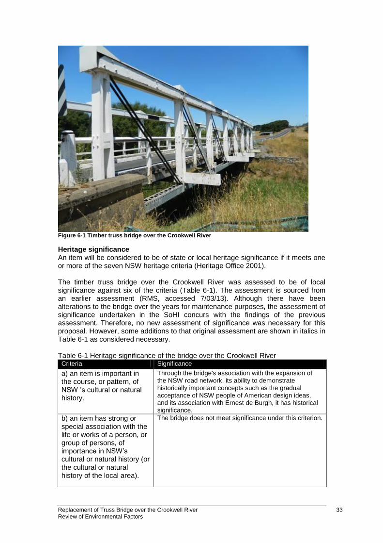
Replacement of Truss Bridge over the Crookwell River 33 Review of Environmental Factors
Figure 6-1 Timber truss bridge over the Crookwell River
Heritage significance An item will be considered to be of state or local heritage significance if it meets one or more of the seven NSW heritage criteria (Heritage Office 2001). The timber truss bridge over the Crookwell River was assessed to be of local significance against six of the criteria (Table 6-1). The assessment is sourced from an earlier assessment (RMS, accessed 7/03/13). Although there have been alterations to the bridge over the years for maintenance purposes, the assessment of significance undertaken in the SoHI concurs with the findings of the previous assessment. Therefore, no new assessment of significance was necessary for this proposal. However, some additions to that original assessment are shown in italics in Table 6-1 as considered necessary. Table 6-1 Heritage significance of the bridge over the Crookwell River Criteria Significance
a) an item is important in the course, or pattern, of NSW ’s cultural or natural history.
Through the bridge's association with the expansion of the NSW road network, its ability to demonstrate historically important concepts such as the gradual acceptance of NSW people of American design ideas, and its association with Ernest de Burgh, it has historical significance.
b) an item has strong or special association with the life or works of a person, or group of persons, of importance in NSW’s cultural or natural history (or the cultural or natural history of the local area).
The bridge does not meet significance under this criterion.
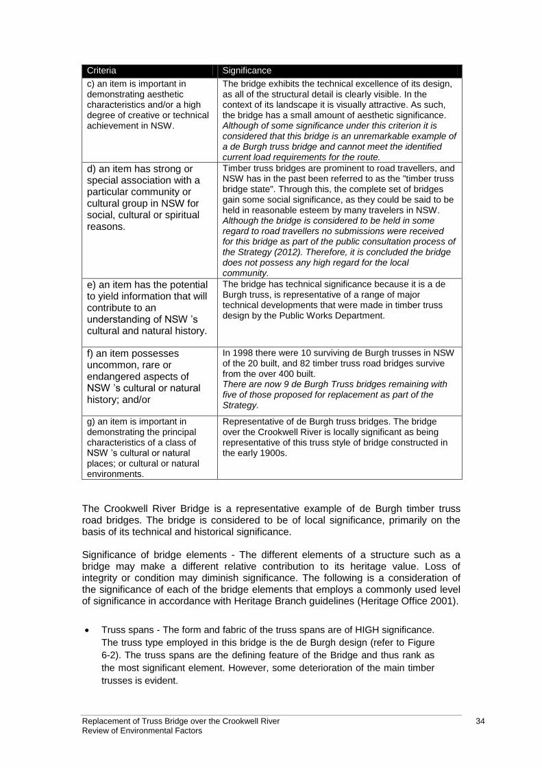
Replacement of Truss Bridge over the Crookwell River 34 Review of Environmental Factors
Criteria Significance
c) an item is important in demonstrating aesthetic characteristics and/or a high degree of creative or technical achievement in NSW.
The bridge exhibits the technical excellence of its design, as all of the structural detail is clearly visible. In the context of its landscape it is visually attractive. As such, the bridge has a small amount of aesthetic significance. Although of some significance under this criterion it is considered that this bridge is an unremarkable example of a de Burgh truss bridge and cannot meet the identified current load requirements for the route.
d) an item has strong or special association with a particular community or cultural group in NSW for social, cultural or spiritual reasons.
Timber truss bridges are prominent to road travellers, and NSW has in the past been referred to as the "timber truss bridge state". Through this, the complete set of bridges gain some social significance, as they could be said to be held in reasonable esteem by many travelers in NSW. Although the bridge is considered to be held in some regard to road travellers no submissions were received for this bridge as part of the public consultation process of the Strategy (2012). Therefore, it is concluded the bridge does not possess any high regard for the local community.
e) an item has the potential to yield information that will contribute to an understanding of NSW ’s cultural and natural history.
The bridge has technical significance because it is a de Burgh truss, is representative of a range of major technical developments that were made in timber truss design by the Public Works Department.
f) an item possesses uncommon, rare or endangered aspects of NSW ’s cultural or natural history; and/or
In 1998 there were 10 surviving de Burgh trusses in NSW of the 20 built, and 82 timber truss road bridges survive from the over 400 built. There are now 9 de Burgh Truss bridges remaining with five of those proposed for replacement as part of the Strategy.
g) an item is important in demonstrating the principal characteristics of a class of NSW ’s cultural or natural places; or cultural or natural environments.
Representative of de Burgh truss bridges. The bridge over the Crookwell River is locally significant as being representative of this truss style of bridge constructed in the early 1900s.
The Crookwell River Bridge is a representative example of de Burgh timber truss road bridges. The bridge is considered to be of local significance, primarily on the basis of its technical and historical significance. Significance of bridge elements - The different elements of a structure such as a bridge may make a different relative contribution to its heritage value. Loss of integrity or condition may diminish significance. The following is a consideration of the significance of each of the bridge elements that employs a commonly used level of significance in accordance with Heritage Branch guidelines (Heritage Office 2001).
Truss spans - The form and fabric of the truss spans are of HIGH significance.
The truss type employed in this bridge is the de Burgh design (refer to Figure
6-2). The truss spans are the defining feature of the Bridge and thus rank as
the most significant element. However, some deterioration of the main timber
trusses is evident.
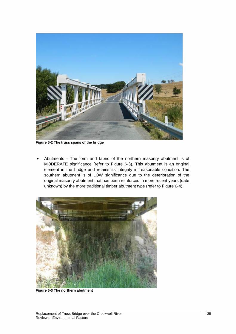
Replacement of Truss Bridge over the Crookwell River 35 Review of Environmental Factors
Figure 6-2 The truss spans of the bridge
Abutments - The form and fabric of the northern masonry abutment is of
MODERATE significance (refer to Figure 6-3). This abutment is an original
element in the bridge and retains its integrity in reasonable condition. The
southern abutment is of LOW significance due to the deterioration of the
original masonry abutment that has been reinforced in more recent years (date
unknown) by the more traditional timber abutment type (refer to Figure 6-4).
Figure 6-3 The northern abutment
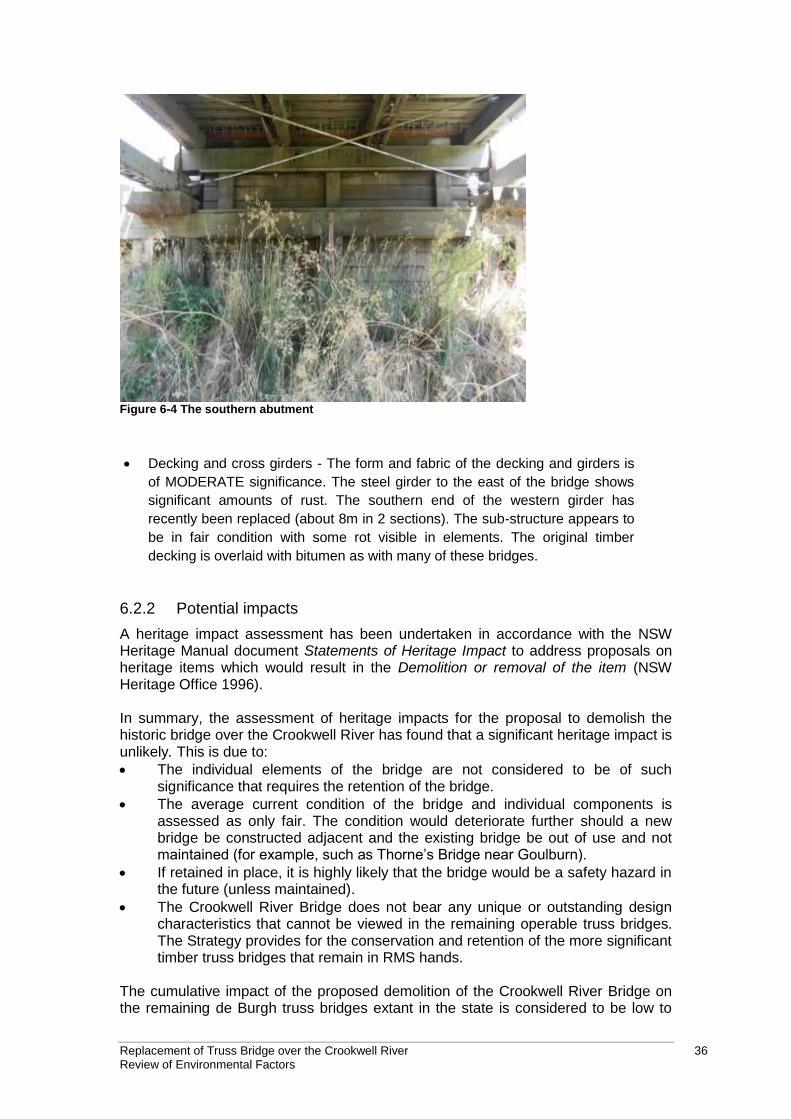
Replacement of Truss Bridge over the Crookwell River 36 Review of Environmental Factors
Figure 6-4 The southern abutment
Decking and cross girders - The form and fabric of the decking and girders is
of MODERATE significance. The steel girder to the east of the bridge shows
significant amounts of rust. The southern end of the western girder has
recently been replaced (about 8m in 2 sections). The sub-structure appears to
be in fair condition with some rot visible in elements. The original timber
decking is overlaid with bitumen as with many of these bridges.
6.2.2 Potential impacts
A heritage impact assessment has been undertaken in accordance with the NSW Heritage Manual document Statements of Heritage Impact to address proposals on heritage items which would result in the Demolition or removal of the item (NSW Heritage Office 1996). In summary, the assessment of heritage impacts for the proposal to demolish the historic bridge over the Crookwell River has found that a significant heritage impact is unlikely. This is due to:
The individual elements of the bridge are not considered to be of such significance that requires the retention of the bridge.
The average current condition of the bridge and individual components is assessed as only fair. The condition would deteriorate further should a new bridge be constructed adjacent and the existing bridge be out of use and not maintained (for example, such as Thorne’s Bridge near Goulburn).
If retained in place, it is highly likely that the bridge would be a safety hazard in the future (unless maintained).
The Crookwell River Bridge does not bear any unique or outstanding design characteristics that cannot be viewed in the remaining operable truss bridges. The Strategy provides for the conservation and retention of the more significant timber truss bridges that remain in RMS hands.
The cumulative impact of the proposed demolition of the Crookwell River Bridge on the remaining de Burgh truss bridges extant in the state is considered to be low to
Replacement of Truss Bridge over the Crookwell River 37 Review of Environmental Factors
moderate. The four de Burgh Bridges that are assessed to be ‘operable’ examples of their type are considered to have higher historic, aesthetic, social and technological value than the Crookwell River Bridge. It is these bridges that would be retained as part of the Strategy.
6.2.3 Safeguards and management measures
Impact Environmental safeguards Responsibility Timing
Demolition of historic bridge
RMS notifies the NSW Heritage Branch (OEH) not less than 14 days prior to any works commencing to remove the s.170 listed bridge. It is a statutory requirement under s.170 that a delisting process with the NSW State Heritage Office be undertaken when transferring or demolishing items listed on an s.170 register.
Under Section 14 of the SEPP (Infrastructure) RMS would provide written notice of the intention to carry out the proposed works, with a copy of this SoHI to the Upper Lachlan Shire Council.
Archival photographic recording of the Truss Bridge over Crookwell River would be completed prior to demolition works.
As there are not many remaining examples of the de Burgh type truss bridge in NSW, the bridge should be included in the proposed RMS Interpretation Strategy/publication.
Demolition of the Crookwell River Bridge should follow the requirements in the RMS Recycling of Used Bridge Timbers policy. All useful parts of the bridges should be salvaged and stockpiled for possible future use.
Contractor and RMS
Pre-construction and construction
Discovery of other heritage items
If unexpected archaeological remains are uncovered during the works, all works must cease in the vicinity of the material/find and the steps in the RTA Standard Management Procedure: Unexpected Archaeological Finds must be followed. Roads and Maritime Services Senior Regional Environmental Officer must be contacted immediately.
If any items defined as relics under the NSW Heritage Act 1977 are uncovered during the works, all works must cease in the vicinity of the find and the Roads and Maritime Services Senior Regional
Contractor and RMS
Construction
Replacement of Truss Bridge over the Crookwell River 38 Review of Environmental Factors
Impact Environmental safeguards Responsibility Timing
Environmental Officer contacted immediately.
6.3 Biodiversity
nghenvironmental carried out a biodiversity assessment to determine the terrestrial and aquatic biodiversity values of the site and surrounding area and potential impacts of the proposal (nghenvironmental, 2013a). This section summarises the Biodiversity Assessment report provided in Appendix D.
6.3.1 Methodology
The field study area for the purposes of this assessment refers to the development footprint which includes the existing truss bridge and the replacement bridge footprint, the road realignments, the temporary site compound and stockpile site, and the Crookwell River in the vicinity of the proposal. nghenvironmental carried out the following database searches to provide background information on threatened species and noxious weeds found in the area: Table 6-2 Databases searched
Resource Target Search date Search area
OEH Wildlife Atlas Data
Threatened flora and fauna and populations
21/12/12 10 km radius of study area
EPBC Act Protected Matters Search
Threatened flora and fauna, endangered populations and ecological communities and migratory species
20/12/12 10 km radius of study area
DPI Records Viewer Threatened fish 18/01/12 Lachlan CMA
DPI Noxious Weed database
Noxious weeds declared in the relevant LGA.
20/12/12 Upper Lachlan Shire Council
Flora survey A detailed flora list for the field study area was compiled using the “random meander” method (Cropper 1993). Flora species present were identified and their abundances were estimated using a qualitative measure (low, medium, or high). An assessment and description of the vegetation communities present in the field study area was undertaken with reference to the structure and condition of vegetation including evidence of past disturbances. Significant exotic species, including noxious weeds, were recorded along with their relative abundance. A full list of the flora species recorded is presented in Appendix A of the Biodiversity Assessment report (refer to Appendix D). Fauna survey An assessment of habitat types available and their quality and suitability as threatened species habitat was conducted across the subject site. Factors such as arboreal resources, ground-layer resources, vegetation structure, connectivity and
Replacement of Truss Bridge over the Crookwell River 39 Review of Environmental Factors
disturbance were noted. An assessment of the site as potential Koala habitat or core Koala habitat was also undertaken, taking into account feed tree densities and evidence of use including scats and scratches. Incidental sightings of fauna and their traces (e.g. scats, tracks, scratches) made while present on the site were also recorded. A record of bird species observed during the fauna assessment was taken. A bat survey comprising stag watching with Anabat devices to observe and record microbats leaving the bridge at dusk was carried out. Two Anabat detectors were set up to record over two nights. Aquatic survey The aquatic environment within the vicinity of the proposal was assessed during field surveys. These surveys aimed to describe the existing environment of the field study area and included an aquatic fauna and flora habitat assessment. Sites were selected with the intention to assess the range of habitats in Crookwell River in the field study area. Three sites were selected, the locations of which are described in Table 6-3. Table 6-3 Sites surveyed
Site Waterway Description
Site 1 Crookwell River Upstream of the existing bridge
Site 2 Crookwell River Downstream of the existing bridge
Site 3 Unnamed drainage line About 300 metres downstream of the confluence with Crookwell River. Within proximity to the northern bounds of the works.
A visual assessment of instream habitat quality at each site was undertaken using the following measures of habitat quality:
Type and condition of riparian vegetation.
Flow types (pools, riffles, runs).
Type of substrate and the presence of bars.
Bed and bank stability and influences.
Favourable habitat features such as snags, woody debris, vegetation and undercuts.
Any physical barriers or influences to fish passage. The presence of native and exotic macrophytes (aquatic plants) was identified at each site. Percentage cover of submerged, floating (free-floating or attached) and emergent macrophytes was recorded. Aquatic vertebrates (in particular, threatened species) of the study area have been described by literature review. Class of waterway was identified according to the definitions in Table 6-4 (Fairfull and Witheridge 2003). Stream order was identified using the Strahler System where waterways are given an ‘order’ according to the number of additional tributaries associated with each waterway (Strahler 1952). Creeks were assessed to determine if they provided Key Fish Habitat in accordance with the definition and maps
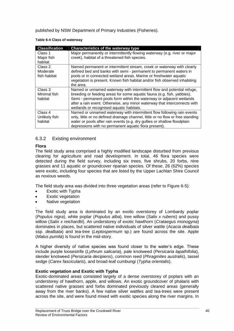
Replacement of Truss Bridge over the Crookwell River 40 Review of Environmental Factors
published by NSW Department of Primary Industries (Fisheries). Table 6-4 Class of waterway
Classification Characteristics of the waterway type
Class 1 Major fish habitat
Major permanently or intermittently flowing waterway (e.g. river or major creek), habitat of a threatened fish species.
Class 2 Moderate fish habitat
Named permanent or intermittent stream, creek or waterway with clearly defined bed and banks with semi - permanent to permanent waters in pools or in connected wetland areas. Marine or freshwater aquatic vegetation is present. Known fish habitat and/or fish observed inhabiting the area.
Class 3 Minimal fish habitat
Named or unnamed waterway with intermittent flow and potential refuge, breeding or feeding areas for some aquatic fauna (e.g. fish, yabbies). Semi - permanent pools form within the waterway or adjacent wetlands after a rain event. Otherwise, any minor waterway that interconnects with wetlands or recognised aquatic habitats.
Class 4 Unlikely fish habitat
Named or unnamed waterway with intermittent flow following rain events only, little or no defined drainage channel, little or no flow or free standing water or pools after rain events (e.g. dry gullies or shallow floodplain depressions with no permanent aquatic flora present).
6.3.2 Existing environment
Flora The field study area comprised a highly modified landscape disturbed from previous clearing for agriculture and road development. In total, 46 flora species were detected during the field survey, including six trees, five shrubs, 20 forbs, nine grasses and 11 aquatic or groundcover riparian species. Of these, 26 (62%) species were exotic, including four species that are listed by the Upper Lachlan Shire Council as noxious weeds. The field study area was divided into three vegetation areas (refer to Figure 6-5):
Exotic with Typha
Exotic vegetation
Native vegetation . The field study area is dominated by an exotic overstorey of Lombardy poplar (Populus nigra), white poplar (Populus alba), tree willow (Salix x rubens) and pussy willow (Salix x reichardtii). An understorey of exotic hawthorn (Crataegus monogyna) dominates in places, but scattered native individuals of silver wattle (Acacia dealbata ssp. dealbata) and tea-tree (Leptospermum sp.) are found across the site. Apple (Malus pumila) is found in the mid-story. A higher diversity of native species was found closer to the water’s edge. These include purple loosestrife (Lythrum salicaria), pale knotweed (Persicaria lapathifolia), slender knotweed (Persicaria decipiens), common reed (Phragmites australis), tassel sedge (Carex fascicularis), and broad-leaf cumbungi (Typha orientalis). Exotic vegetation and Exotic with Typha Exotic-dominated areas consisted largely of a dense overstorey of poplars with an understorey of hawthorn, apple, and willows. An exotic groundcover of phalaris with scattered native grasses and forbs dominated previously cleared areas (generally away from the river banks). A few native silver wattles and tea-trees were present across the site, and were found mixed with exotic species along the river margins. In
Replacement of Truss Bridge over the Crookwell River 41 Review of Environmental Factors
the exotic area to the east of the bridge, the dense canopy along the river bank shades out most native species, with a canopy cover of over 80%. As the distance from the banks increases, the overstorey cover drops to 0% and groundcovers become dominant. The zone shown as exotic with Typha in Figure 6-5 was dominated by an exotic overstorey and a generally exotic understorey, with some small patches of native broad-leaf cumbungi. The overstorey was again very dense, with a canopy cover of over 80%. The batter here is largely exotic, with some scattered native forbs and Typha present in wetter areas. The groundcovers underneath the poplars and hawthorns here are generally exotic and blackberry was fairly common at the base of the batter. Native vegetation An area to the northwest of the bridge (Figure 6-5) contains three hollow-bearing trees, including a large native Argyle apple (Eucalyptus cinerea), and scattered native shrubs and grasses. While a large component of this zone consisted of exotic forbs and shrubs, there were regenerating eucalypts here as well. The overstorey canopy cover was quite low, around 5-15%, which is indicative of woodland. The site was very degraded, but is probably derived from the vegetation class known as Southern Tableland Grassy Woodlands. However, because the field study is dominated by exotics at both an overstorey and a groundcover level, it is difficult to determine which specific vegetation community was present before clearing. Threatened flora species NSW OEH Wildlife Atlas database searches for threatened species revealed seven flora species that are known to occur or have the potential to occur within 10 km of the project site. Commonwealth EPBC searches revealed four flora species that have the potential to occur within 10 km of the project site. Targeted searches of the area did not detect any of these species. Given the highly disturbed and degraded nature of the field study area and the dominance of exotic species the site is unlikely to support a population of these threatened plants. A detailed justification of this conclusion is provided for each of the 11 threatened flora species in Appendix D of the full report (Appendix D). Noxious weeds Four noxious weeds were identified in the field study area including Sweet briar (Rosa rubiginosa), Blackberry (Rubus fruticosus), Paterson’s curse (Echium plantagineum) and a hybrid of golden willow and crack willow (Salix x rubens). Threatened Ecological Communities NSW OEH Wildlife Atlas database searches for Endangered Ecological Communities (EECs) revealed three EECs with the potential to occur in the field study area.
Tableland Basalt Forest in the Sydney Basin and South Eastern Highlands Bioregions.
Tablelands Snow Gum, Black Sallee, Candlebark and Ribbon Gum Grassy Woodland in the South Eastern Highlands, Sydney Basin, South East Corner and NSW South Western Slopes Bioregions.
White Box Yellow Box Blakely’s Red Gum Woodland. The Commonwealth Protected Matters Search Tool (EPBC Act) revealed two EECs which have the potential to occur within 10 km of the field study area.
Natural Temperate Grassland of the Southern Tablelands of NSW and the Australian Capital Territory.
White Box-Yellow Box-Blakely's Red Gum Grassy Woodland and Derived Native Grassland.
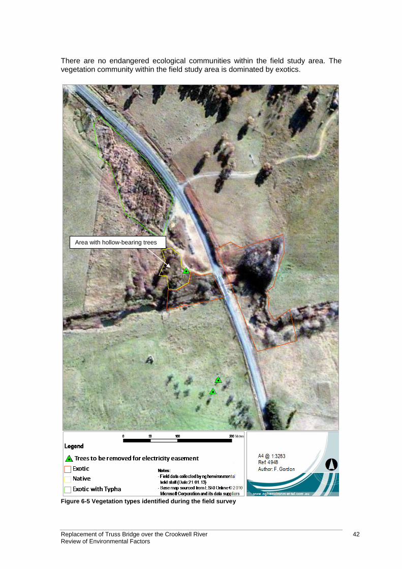
Replacement of Truss Bridge over the Crookwell River 42 Review of Environmental Factors
There are no endangered ecological communities within the field study area. The vegetation community within the field study area is dominated by exotics.
Area with hollow-bearing trees
Figure 6-5 Vegetation types identified during the field survey
Replacement of Truss Bridge over the Crookwell River 43 Review of Environmental Factors
Fauna Terrestrial Fauna Thirty-one fauna species were detected during the field surveys; 18 bird, ten mammal, and one amphibian species. For a complete species list refer to Appendix E of the full report (Appendix D). Five species of microbat were confidently identified. They included the White-striped Mastiff Bat (Tadarida australis), Gould’s Wattled Bat (Chalinolobus gouldii), Chocolate Wattled Bat (Chalinolobus morio), Southern Forest Bat (Vespadelus regulus), and Large Forest Bat (Vespadelus darlingtoni). Those species identified with ‘probable’ certainty included the Little Forest Bat (Vespadelus vulturnus) and Nyctophilis spp., which cannot be identified to species based on calls. Two threatened species were identified with ‘possible’ certainty, and included the Eastern Bent-wing Bat (Miniopterus schreibersii oceanensis) and Eastern false pipistrelle (Falsistrellus tasmaniensis), both listed as vulnerable under the TSC Act. Fauna habitat value at the site is low. Exotic species such as rabbits and foxes are likely to be common across the landscape. Frogs were not found in the Crookwell River during the survey. The only frog activity found was at the culvert at the northern extent of the works, occupied by the Striped Marsh Frog (Limnodynastes peroni), a very common species. No eucalypt species occur within the subject site, therefore the site does not constitute potential or core koala habitat under SEPP 44 –Koala Habitat Protection. The site is unlikely to provide habitat for koalas. Threatened fauna species NSW Wildlife Atlas database searches for threatened species listed on the TSC Act identified 23 bird species, three reptile, one amphibian, eight mammal, and one invertebrate species within 10 km of the field survey area (Appendix A and B of the full report). The EPBC Act protected matters search tool revealed five bird, two reptile, one amphibian, two mammal, two aquatic, and 11 migratory bird species with the potential to occur within 10 km of the field study area (Appendix A and B of the full report). According to the results of the Anabat survey two threatened microbat species may occur in the area, the Eastern Bent-wing Bat and Eastern False pipistrelle, both listed as vulnerable under the TSC Act. The bridge provides potential roosting habitat for both of these species, therefore a Seven Part Test has been prepared (refer to 6.1.3 and Appendix F of the full report). Other threatened species may use the field study area on occasion, such as waterbirds (See Appendix E of Appendix D). However, disturbance at the site would only be temporary, and would only impact a small amount of potential habitat. Disturbance to this habitat is not critical to the survival of any threatened species, and considering the high mobility of species that may utilise the site on occasion, they are unlikely to be impacted and have not been considered any further. Overall, the field study area in its present disturbed condition is unlikely to provide valuable habitat to any threatened fauna species. Aquatic The Crookwell River is a Class 1 waterway according to Fairfull and Witheridge (2003) as it is a major river and habitat is available for a range of species, including
Replacement of Truss Bridge over the Crookwell River 44 Review of Environmental Factors
threatened species. The Crookwell River within proximity to the proposal is at least a third order stream according to the Strahler Stream order (Strahler 1952). This reach of the Crookwell River is considered Key Fish Habitat according to NSW Department of Fisheries mapping. The unnamed tributary which drains into the Crookwell River downstream of the existing bridge, is a Class 4 waterway according to Fairfull and Witheridge (2003) as it has intermittent flow following rain events only, little or no defined drainage channel, little or no flow or free standing water or pools after rain events. The culvert that would be replaced as part of the works drains to the unnamed tributary. Threatened Aquatic Species, Populations and Communities The Lachlan Catchment supports a diverse assemblage of species. The pressures from introduced species, as well as other factors such as reduced water quality, increased fishing pressure, and habitat degradation, have likely resulted in a decline in the population densities of native fish (DPI 2006). A search of relevant databases and literature have identified that four threatened species and one endangered population have the potential to occur within the Crookwell River, within the vicinity of the works:
Bidyanus bidyanus, Silver Perch - Listed as Vulnerable on the FM Act.
Maccullochella peelii, Murray Cod - Listed as Vulnerable on the EPBC Act.
Macquaria australasica, Macquarie Perch - Listed as Endangered on the FM Act and Endangered on the EPBC Act.
Nannoperca australis, Southern Pygmy Perch - Listed as Endangered on the FM Act.
The Murray Darling Basin population of the eel-tailed catfish Listed as Endangered on the FM Act.
The stream is mostly pooled, with pools separated by vegetated sediment bars and small boulders. Instream vegetation was relatively diverse upstream of the bridge. Species lining the wetted stream included common reed (Phragmites australis), Knotweeds (Persicaria spp.) and sedges (Carex fascicularis and Cyperus sp.). Some submerged vegetation was observed in slow flowing areas of the pools (Vallisneria americana and Myriophyllum caput-medusae). Some shading was provided by trees along the banks. Predominant instream habitat features upstream of the bridge included small boulders and woody debris, small areas of gravel beds and some riffles between pools. Instream habitat was largely diversified by the vegetation which provided shading, overhanging roots, trailing vegetation and instream habitat amongst submerged and emergent vegetation. There was also a series of pooled areas which is a key habitat feature for many species. Fish activity within the upstream pools was observed during dusk surveys, although identification could not be confirmed. An eastern long-necked turtle (Chelodina longicollis) and a Water Rat (Hydromys chrysogaster) were observed in the pools upstream of the existing bridge. Downstream of the bridge, habitat was less complex where instream, and some overhanging vegetation, provided habitat. Downstream of the proposed works, the river had steep banks which were greater
Replacement of Truss Bridge over the Crookwell River 45 Review of Environmental Factors
than two metres high. There were some trees scattered along the upper banks, however, these were sparse and provided little shading over the channel. Beneath the bridge and downstream of the bridge, instream vegetation was dense, dominated by Common Reed, Sedges and Knotweeds. The stream was separated by vegetated sediment bars. The unnamed channel north of the Crookwell River was dominated by dense exotic vegetation, as described above. The channel was shallow (bank heights around one metre) and the ground was moist in most areas. It is likely there is some subsurface flow as there was flow evident in some reaches of the channel. There was very little habitat for aquatic vertebrates during low flow conditions observed on site. Erosion of the river bank as a result of runoff was particularly evident downstream of the existing bridge. Gabion baskets had been installed as a means of protection against erosion. The site does not contain any areas that have been declared as critical habitat under the TSC Act. The Crookwell River and its associated riparian vegetation acts as a natural corridor for terrestrial and aquatic fauna.
6.3.3 Potential impacts
Approximately 1.1 hectares of vegetation would be impacted by the proposal. The vegetation to be removed is mainly exotic grassland. The relocation of the three power poles on the western side of the road requires the removal of three trees. The mature hollow-bearing tree to be removed from the edge of the compound site, north-west of the bridge (refer to Figure 6-5), has the potential to provide habitat for hollow dependent avifauna and microbats including threatened species. Hollow-bearing trees are a limited resource within this cleared agricultural landscape, and while the loss of one tree is unlikely to have a significant impact upon these mobile species, it still constitutes the loss of a habitat component that is a limiting resource and will not be replaced. Alternatives to this option have been investigated by RMS, and have succeeded in avoiding the large Argyle Apple on site, an important hollow-bearing tree within the landscape. The remaining two trees to be removed are planted plum trees (Prunus spp.) which are not native. Their loss is deemed inconsequential in relation to biodiversity. Large trees to be removed are exotic species such as willows and poplars and one native hollow-bearing tree at the edge of the compound site northwest of the bridge. Some native species would be removed. All native species of vegetation to be removed during the proposed works are common and widespread, and often found in disturbed or degraded environments. The higher-quality patch of vegetation to the northwest of the bridge has a sparse native overstorey as well as native shrubs and regenerating eucalypts. This area should be retained where possible (refer to Figure 6-5). No endangered ecological communities would be impacted by the proposal. The relocation of the power line would require the removal of the hollow-bearing tree on the edge of the compound site and two plum trees. However, the relocation route would avoid two large hollow bearing trees located to the west of compound located on the north western side of the existing bridge (refer to Figure 3-1). The bridge provides potential habitat for roosting microbats. From the results of the field survey it is unlikely that the bridge is an important habitat resource for microbats
Replacement of Truss Bridge over the Crookwell River 46 Review of Environmental Factors
and/or other fauna. Microbats may use the bridge as a temporary roosting site on occasion, therefore safeguard and management measures prior to construction have been recommended in section 6.3.4. The results of the survey indicate that the bridge is unlikely to provide a permanent roosting site for threatened microbats. The Crookwell River is likely to provide a foraging resource for threatened bats and other threatened species such as birds. However, the proposed works would have minimal on this foraging habitat due to the relatively small footprint of the works and their temporary nature and similar habitat available downstream and upstream. Therefore, the proposed works would be unlikely to impact these species. The Seven-part Test concluded that the proposal is not likely to significantly affect the threatened microbat species detected in the study area, either directly or indirectly, provided the recommended safeguards are carried out. The corridor of willow trees on the banks of the Crookwell River maintain habitat connectivity along the banks of the Crookwell River and are likely to provide habitat for some fauna. However, the majority of this habitat would not be impacted by the works. Some disturbance to instream vegetation may prevent terrestrial wildlife movement along the Crookwell River, however, this will be temporary and the site will be rehabilitated post-construction. Risk of spread of the four noxious weed species observed in the field study area has the potential to occur during vegetation removal and movement of machinery. Each species requires particular treatment to be successfully managed and advice should be sought before removal. Willows present within the creekline to the west of the existing bridge will be removed as part of the proposed works. Particular care should be taken when trimming or removing Willows, as these species are difficult to fully remove from the site due to their ability to reproduce vegetatively. Pathogens such as Phytophthora and Chytrid have the potential to be introduced or spread during the proposed construction works in the field study area. They are listed as Key Threatening Processes (KTPs) under both the TSC Act and EPBC Act. Construction activities within and adjacent to the Crookwell River and the unnamed tributary to its north have the potential to create erosion and sedimentation which could impact water quality, aquatic habitats and aquatic flora and fauna at the site and further downstream. Erosion and sedimentation is assessed in section 6.1. Potential impacts on aquatic fauna would include:
Reduction of light penetration (as a result of increased turbidity) and subsequent reduction of aquatic macrophytes (loss of habitat).
Loss of aquatic habitats such as rocky areas, riffles and macrophytes Riparian vegetation and bank form within the Crookwell River at the proposed works area would be impacted by the proposed scour remediation works. However, this would improve the erosive resistance of the bank in the long term. Construction of the bridge would require the use of temporary instream structures which may impact the free passage of fish. The instream structures would include temporary platforms constructed by placing large size rocks over a layer of pipes that would be placed on the river bed allowing the passage of water flows and fish at all times. This platform would be removed upon completion of the proposed works. Instream structures have the potential to directly impact and remove aquatic habitat through reclamation. The footprint of the proposed bridge which would include four piles within the channel would only have minimal impact on the availability of aquatic habitats. This area is also currently disturbed compared to other areas further
Replacement of Truss Bridge over the Crookwell River 47 Review of Environmental Factors
upstream which would not be impacted. Four threatened fish species (silver perch, Murray cod, Macquarie perch, southern pygmy perch) and one population (eel-tailed catfish) have the potential to occur within the Crookwell River. None of these species are likely to use the unnamed tributary which runs north of the Crookwell River. If fish passage is maintained throughout the proposed works, potential impacts to threatened species would be minimised. There is the potential to have some impact to these species through the direct removal of habitat within the proposed bridge footprint. However, this would be minimal due to the disturbed nature of the impact area and the availability of higher quality habitat further upstream. Seven part tests and Assessments of Significance have been undertaken for threatened fish species and population with the potential to occur at the site (refer to Appendix F of the full report). The assessments have concluded that the proposal is not likely to significantly affect the threatened aquatic fauna species considered with the potential to occur in the field study area, either directly or indirectly. Potential impacts may also result from water quality impacts, especially during the breeding periods, though these are unlikely to have a significant impact on any threatened species with the implementation of mitigation measures outlined in section 6.3.4. A Species Impact Statement is not required for the proposal and the proposed works does not need to be referred to the DSEWPC.
6.3.4 Safeguards and management measures
Impact Environmental safeguards Responsibility Timing
Vegetation removal
Prior to the commencement of works a physical vegetation clearing boundary is to be demarcated and implemented to prevent accidental over clearing. The delineation of such a boundary may include the use of flagging tape, parawebbing or similar.
All vegetation removal is to be done in accordance with the RTA Biodiversity Guidelines – Protecting and Managing Biodiversity on RTA Projects (RTA 2011).
Where possible, mature vegetation should be avoided to maintain habitat connectivity and bank stability.
Areas already impacted by previous clearing or disturbance should be preferentially utilised over undisturbed areas or where native vegetation is present.
Revegetation of the site with locally occurring native flora species typical of the original riparian habitat will improve habitat for both native and threatened species which have the potential to occur in the area.
Contractor Pre-construction and construction
Replacement of Truss Bridge over the Crookwell River 48 Review of Environmental Factors
Impact Environmental safeguards Responsibility Timing
Fauna impacts
A pre-clearing survey for roosting microbats will be conducted by a suitably qualified ecologist immediately prior to the demolition of the bridge.
If microbats are found during the preclearing survey, an ecologist would be present during the demolition of the bridge to capture any additional bats.
Fauna handling must be carried out in accordance with the requirements the RTA Biodiversity Guidelines - Guide 9 (Fauna Handling).
If unexpected threatened fauna or flora species are discovered, stop works immediately and follow the RTA Unexpected Threatened Species Find Procedure in the RTA Biodiversity Guidelines 2011 – Guide 1 (Pre-clearing process).
Contractor Pre-construction
Noxious weeds
The requirements of the Noxious Weeds Act 1993 will be followed, and any weed removal activities should follow Guide 6 (Weed Management) in the RMS Biodiversity Guidelines, the Noxious Weeds Act 1993 and the Upper Lachlan Shire Council Noxious Weeds Policy (2009).
The contractor is to prepare and implement a machinery hygiene protocol. Machinery would be cleaned prior to entering the site to ensure that weed seeds and propagules are not imported to the site.
Particular care should be taken when trimming or removing Willows, as these species are notorious for being difficult to fully remove from the site due to their ability to reproduce vegetatively.
Contractor Pre-construction and construction
Pests and pathogens
The proposed works should follow the best practice hygiene guidelines in the RMS Biodiversity Guidelines (Guide 7: Pathogen Management) to prevent their introduction or spread.
Contractor Pre-construction and construction
Impacts on riparian vegetation
The proposed development will be undertaken within the riparian zone of the Crookwell River. As such, the works should follow Guide 10 (Aquatic Habitats and Riparian Zones) in the RMS Biodiversity Guidelines to minimise potential impacts. Considerations relevant to
Contractor Pre-construction and construction
Replacement of Truss Bridge over the Crookwell River 49 Review of Environmental Factors
Impact Environmental safeguards Responsibility Timing
the proposal will include clearing of riparian vegetation and site rehabilitation.
Impacts on fish
DPI (fisheries) should be notified of the proposed reclamation as part of the works under section 198 of the Fisheries Management Act 1994.
Should any fish kills occur during construction, all works would stop and DPI (Fisheries) and the RMS local environmental officer would be contacted immediately.
Construction methods within the waterway should ensure that the free passage of fish downstream and upstream is maintained at all times.
The use of a silt curtain should be considered to minimise potential downstream impacts. A risk assessment should be undertaken prior to use to ensure the use of the silt curtain would not cause more disturbance than the proposed construction activity. The silt curtain should be used in such a way as not to restrict fish passage.
Contractor and RMS
Construction
Impacts on the aquatic environment
Where instream works cannot be avoided, the instream works footprint should be minimised as to avoid impacts to instream vegetation and fish habitat.
Removal of instream habitat structures such as boulders, vegetation and large woody debris, should be avoided where possible. Any relocation/removal would be done in consultation with DPI Fisheries
The design and location of the bridge piles should ensure that any modification to local hydrology as a result of these would not cause bank erosion or encourage sediment build-up around the structure.
If feasible, instream works with a high potential to impact water quality (e.g. piling activities) should be avoided during the breeding period of aquatic species (spring/summer).
Contractor and RMS
Pre-construction and construction
6.4 Hydrology and flooding
6.4.1 Existing environment
The Crookwell River is an arterial waterway in the upper reaches of the Lachlan
Replacement of Truss Bridge over the Crookwell River 50 Review of Environmental Factors
Catchment. It drains into Lake Wyangala (dammed) more than 50 kilometres downstream, north of the proposed works. The Crookwell River within the vicinity of the proposed works is around 30 metres wide and its form is highly variable. The river flows in a westerly direction in the area of the site. Predominant instream features upstream of the bridge included small boulders and woody debris, small areas of gravel beds and some riffles between pools. Downstream of the proposed works, the river had steep banks which were high, greater than two metres. The build up of sediment within the river downstream of the bridge has altered the flow of the river and may have potentially caused scouring of the southern bank. No information on flood zones within the locality are available. Upper Lachlan Shire council is currently undertaking flood studies. However, the deck of the proposed bridge and surrounding land at the same level is above the 1 in 100 year flood level.
6.4.2 Potential impacts
If a catastrophic event were to occur such as the bridge collapsing during demolition there could be potential temporary impacts on the local hydrology. The demolition of the bridge would be undertaken section by section with the bridge being supported by beams and scaffolding. This would minimise any potential risk of collapse of the bridge. The proposed works and the compound site would be located in an area where floods may occur. The deck of the proposed bridge would be above the 1 in 100 year flood level. This means that the compound site on the north western side of the bridge would not be likely to be impacted by a 1 in 100 year flood. However, if flooding should occur during the proposed works, major water quality impacts may results if construction plant in the river and the compound site on the south eastern side of the bridge are not removed from the site. Monitoring of any potential floods and preparation of a flood contingency plan as described in section 6.4.3 would avoid any potential impacts. The proposed bridge would have two pier supports in the river channel. The piers would comprise two 1050 millimetre diameter piles each. The piers represent about 7% of the channel and would be unlikely to substantially impact the flow in the Crookwell River. The piles could result in minor local changes in flow which could result in erosion and sedimentation. The proposal would have a positive impact on hydrology by preventing scouring at the bend in the river to the east of the existing bridge and at the southern abutment of the proposed bridge. The scour protection works would prevent further changes to the river hydrology by stabilising this area. The build-up of sediment in the waterway near the southern abutment of the proposed bridge would be removed. This would improve river flow in this area of the river and prevent potential further scouring of the banks.
6.4.3 Safeguards and management measures
Impact Environmental safeguards Responsibility Timing
Impacts on hydrology
The bridge piles would be designed to minimise potential hydrological
RMS Design
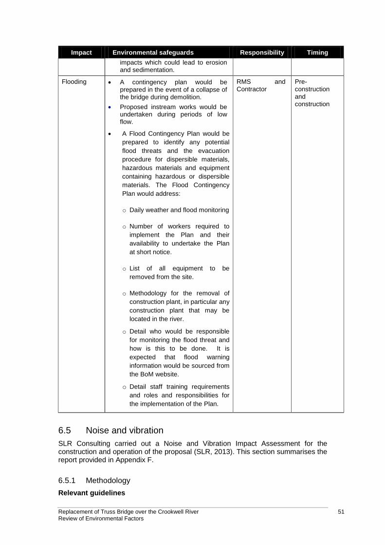
Replacement of Truss Bridge over the Crookwell River 51 Review of Environmental Factors
Impact Environmental safeguards Responsibility Timing
impacts which could lead to erosion and sedimentation.
Flooding A contingency plan would be prepared in the event of a collapse of the bridge during demolition.
Proposed instream works would be undertaken during periods of low flow.
A Flood Contingency Plan would be
prepared to identify any potential
flood threats and the evacuation
procedure for dispersible materials,
hazardous materials and equipment
containing hazardous or dispersible
materials. The Flood Contingency
Plan would address:
o Daily weather and flood monitoring
o Number of workers required to
implement the Plan and their
availability to undertake the Plan
at short notice.
o List of all equipment to be
removed from the site.
o Methodology for the removal of
construction plant, in particular any
construction plant that may be
located in the river.
o Detail who would be responsible
for monitoring the flood threat and
how is this to be done. It is
expected that flood warning
information would be sourced from
the BoM website.
o Detail staff training requirements
and roles and responsibilities for
the implementation of the Plan.
RMS and Contractor
Pre-construction and construction
6.5 Noise and vibration
SLR Consulting carried out a Noise and Vibration Impact Assessment for the construction and operation of the proposal (SLR, 2013). This section summarises the report provided in Appendix F.
6.5.1 Methodology
Relevant guidelines
Replacement of Truss Bridge over the Crookwell River 52 Review of Environmental Factors
The noise and vibration guidelines for construction and operations are based on the publications managed by the Environmental Protection Authority (EPA). The guidelines applicable to this assessment include:
Operational Noise – Road Noise Policy (RNP), DECCW 2011.
Construction Noise – Interim Construction Noise Guideline (ICNG), DECC 2009.
Construction Vibration (human comfort) – Assessing Vibration a technical guideline, DEC 2006.
Construction Vibration (damage limits) – German Standard DIN 4150, Part 3: Structural Vibration in Buildings: Effects on Structures.
In order to characterise the noise environment across the project area and to establish existing ambient noise levels upon which to base the noise emission targets, environmental noise monitoring was performed at representative locations within the project area. The ambient noise monitoring locations L1 and L2 are indicated in Figure 6-6. Both attended and unattended ambient measurements were taken at each monitoring location. In addition, in order to assist with operational noise prediction, operator attended vehicle pass-by noise measurements were undertaken at representative positions within the project area. The rating background level (RBL) was established for each monitoring location. Construction noise management levels (NML) were established using the RBL according to the ICNG. The major construction scenarios were identified and noise levels estimated for each scenario. The estimated noise levels were compared to the NMLs to determine the construction noise impact of the proposal. Operational noise goals were established in accordance with the RNP.
6.5.2 Existing environment
The study area extends along both sides of the road corridor in the vicinity of the works. The land adjacent to the road corridor in the study area is predominantly characterised as rural-residential with large open spaces of grassland and areas with undulating topography. Four nearby sensitive receivers were identified (refer to Table 6-5 and Figure 6-6). Table 6-5 Nearby sensitive receivers
Location Lot Brief Description
R1 115DP753012 About 230m from Binda Road. Residential, direct line of sight to bridge and approach from the south, northern approach partially shielded by earth mound
R2 1DP1035308 About 50m from Binda Road. Residential, direct line of sight to bridge, approaches partially shielded by topography
R3 42DP753012 About 400m west of Binda Road. Residential receiver.
R4 1DP10404727 About 900m west of Binda Road Residential receiver.
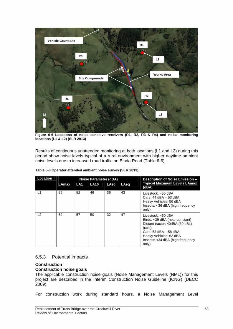
Replacement of Truss Bridge over the Crookwell River 53 Review of Environmental Factors
N
L1 R3
R4 R2
R1
Site Compounds
Vehicle Count Site
L2
Works Area
Figure 6-6 Locations of noise sensitive receivers (R1, R2, R3 & R4) and noise monitoring locations (L1 & L2) (SLR 2013)
Results of continuous unattended monitoring at both locations (L1 and L2) during this period show noise levels typical of a rural environment with higher daytime ambient noise levels due to increased road traffic on Binda Road (Table 6-6). Table 6-6 Operator attended ambient noise survey (SLR 2013)
Location Noise Parameter (dBA) Description of Noise Emission – Typical Maximum Levels LAmax (dBA)
LAmax LA1 LA10 LA90 LAeq
L1 56 52 46 36 43 Livestock: ~55 dBA Cars: 44 dBA – 53 dBA Heavy Vehicles: 56 dBA Insects: <36 dBA (high frequency only)
L2 62 57 50 32 47 Livestock: ~50 dBA Birds: ~39 dBA (near constant) Distant tractor: 40dBA (60 dBL) (rare) Cars: 53 dBA – 58 dBA Heavy Vehicles: 62 dBA Insects: <34 dBA (high frequency only)
6.5.3 Potential impacts
Construction Construction noise goals The applicable construction noise goals (Noise Management Levels (NML)) for this project are described in the Interim Construction Noise Guideline (ICNG) (DECC 2009). For construction work during standard hours, a Noise Management Level
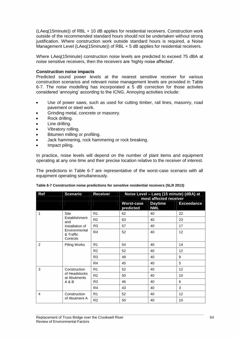
Replacement of Truss Bridge over the Crookwell River 54 Review of Environmental Factors
(LAeq(15minute)) of RBL + 10 dB applies for residential receivers. Construction work outside of the recommended standard hours should not be undertaken without strong justification. Where construction work outside standard hours is required, a Noise Management Level (LAeq(15minute)) of RBL + 5 dB applies for residential receivers. Where LAeq(15minute) construction noise levels are predicted to exceed 75 dBA at noise sensitive receivers, then the receivers are ‘highly noise affected’. Construction noise impacts Predicted sound power levels at the nearest sensitive receiver for various construction scenarios and relevant noise management levels are provided in Table 6-7. The noise modelling has incorporated a 5 dB correction for those activites considered ‘annoying’ according to the ICNG. Annoying activities include:
Use of power saws, such as used for cutting timber, rail lines, masonry, road pavement or steel work.
Grinding metal, concrete or masonry.
Rock drilling.
Line drilling.
Vibratory rolling.
Bitumen milling or profiling.
Jack hammering, rock hammering or rock breaking.
Impact piling. In practice, noise levels will depend on the number of plant items and equipment operating at any one time and their precise location relative to the receiver of interest. The predictions in Table 6-7 are representative of the worst-case scenario with all equipment operating simultaneously. Table 6-7 Construction noise predictions for sensitive residential receivers (SLR 2013)
Ref Scenario Receiver Noise Level – Laeq (15 minute) (dBA) at most affected receiver
Worst-case predicted
Daytime NML
Exceedance
1 Site Establishment and Installation of Environmental & Traffic Controls
R1 62 40 22
R2 63 40 23
R3 57 40 17
R4 52 40 12
2 Piling Works R1 54 40 14
R2 52 40 12
R3 49 40 9
R4 45 40 5
3 Construction of Headstocks at Abutments A & B
R1 52 40 12
R2 50 40 10
R3 46 40 6
R4 43 40 3
4 Construction of Abutment A
R1 52 40 12
R2 50 40 10
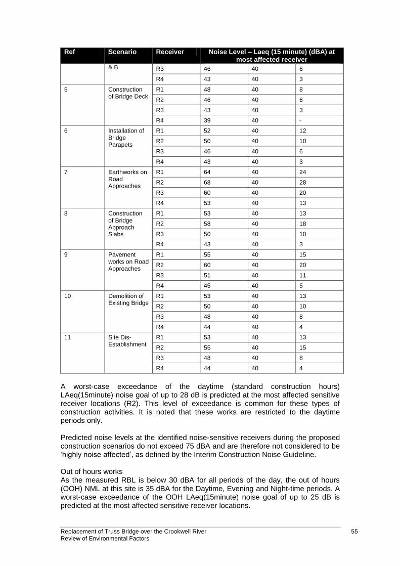
Replacement of Truss Bridge over the Crookwell River 55 Review of Environmental Factors
Ref Scenario Receiver Noise Level – Laeq (15 minute) (dBA) at most affected receiver
& B R3 46 40 6
R4 43 40 3
5 Construction of Bridge Deck
R1 48 40 8
R2 46 40 6
R3 43 40 3
R4 39 40 -
6 Installation of Bridge Parapets
R1 52 40 12
R2 50 40 10
R3 46 40 6
R4 43 40 3
7 Earthworks on Road Approaches
R1 64 40 24
R2 68 40 28
R3 60 40 20
R4 53 40 13
8 Construction of Bridge Approach Slabs
R1 53 40 13
R2 58 40 18
R3 50 40 10
R4 43 40 3
9 Pavement works on Road Approaches
R1 55 40 15
R2 60 40 20
R3 51 40 11
R4 45 40 5
10 Demolition of Existing Bridge
R1 53 40 13
R2 50 40 10
R3 48 40 8
R4 44 40 4
11 Site Dis-Establishment
R1 53 40 13
R2 55 40 15
R3 48 40 8
R4 44 40 4
A worst-case exceedance of the daytime (standard construction hours) LAeq(15minute) noise goal of up to 28 dB is predicted at the most affected sensitive receiver locations (R2). This level of exceedance is common for these types of construction activities. It is noted that these works are restricted to the daytime periods only. Predicted noise levels at the identified noise-sensitive receivers during the proposed construction scenarios do not exceed 75 dBA and are therefore not considered to be ‘highly noise affected’, as defined by the Interim Construction Noise Guideline. Out of hours works As the measured RBL is below 30 dBA for all periods of the day, the out of hours (OOH) NML at this site is 35 dBA for the Daytime, Evening and Night-time periods. A worst-case exceedance of the OOH LAeq(15minute) noise goal of up to 25 dB is predicted at the most affected sensitive receiver locations.
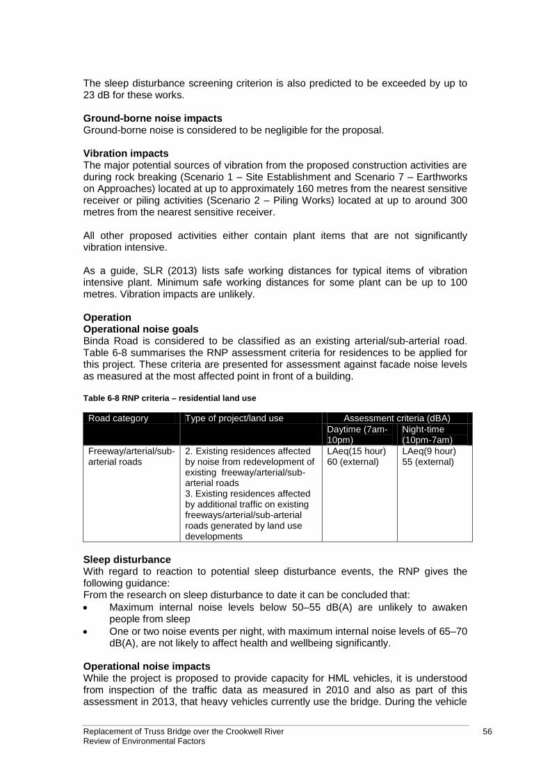
Replacement of Truss Bridge over the Crookwell River 56 Review of Environmental Factors
The sleep disturbance screening criterion is also predicted to be exceeded by up to 23 dB for these works. Ground-borne noise impacts Ground-borne noise is considered to be negligible for the proposal. Vibration impacts The major potential sources of vibration from the proposed construction activities are during rock breaking (Scenario 1 – Site Establishment and Scenario 7 – Earthworks on Approaches) located at up to approximately 160 metres from the nearest sensitive receiver or piling activities (Scenario 2 – Piling Works) located at up to around 300 metres from the nearest sensitive receiver. All other proposed activities either contain plant items that are not significantly vibration intensive. As a guide, SLR (2013) lists safe working distances for typical items of vibration intensive plant. Minimum safe working distances for some plant can be up to 100 metres. Vibration impacts are unlikely. Operation Operational noise goals Binda Road is considered to be classified as an existing arterial/sub-arterial road. Table 6-8 summarises the RNP assessment criteria for residences to be applied for this project. These criteria are presented for assessment against facade noise levels as measured at the most affected point in front of a building. Table 6-8 RNP criteria – residential land use
Road category Type of project/land use Assessment criteria (dBA)
Daytime (7am-10pm)
Night-time (10pm-7am)
Freeway/arterial/sub-arterial roads
2. Existing residences affected by noise from redevelopment of existing freeway/arterial/sub-arterial roads 3. Existing residences affected by additional traffic on existing freeways/arterial/sub-arterial roads generated by land use developments
LAeq(15 hour) 60 (external)
LAeq(9 hour) 55 (external)
Sleep disturbance With regard to reaction to potential sleep disturbance events, the RNP gives the following guidance: From the research on sleep disturbance to date it can be concluded that:
Maximum internal noise levels below 50–55 dB(A) are unlikely to awaken people from sleep
One or two noise events per night, with maximum internal noise levels of 65–70 dB(A), are not likely to affect health and wellbeing significantly.
Operational noise impacts While the project is proposed to provide capacity for HML vehicles, it is understood from inspection of the traffic data as measured in 2010 and also as part of this assessment in 2013, that heavy vehicles currently use the bridge. During the vehicle
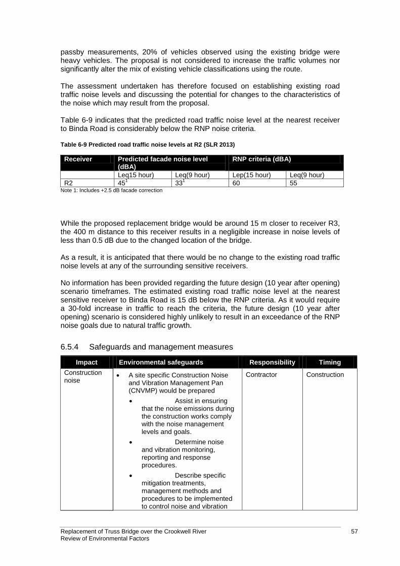
Replacement of Truss Bridge over the Crookwell River 57 Review of Environmental Factors
passby measurements, 20% of vehicles observed using the existing bridge were heavy vehicles. The proposal is not considered to increase the traffic volumes nor significantly alter the mix of existing vehicle classifications using the route. The assessment undertaken has therefore focused on establishing existing road traffic noise levels and discussing the potential for changes to the characteristics of the noise which may result from the proposal. Table 6-9 indicates that the predicted road traffic noise level at the nearest receiver to Binda Road is considerably below the RNP noise criteria. Table 6-9 Predicted road traffic noise levels at R2 (SLR 2013)
Receiver Predicted facade noise level (dBA)
RNP criteria (dBA)
Leq15 hour) Leq(9 hour) Lep(15 hour) Leq(9 hour)
R2 451
331
60 55 Note 1: Includes +2.5 dB facade correction
While the proposed replacement bridge would be around 15 m closer to receiver R3, the 400 m distance to this receiver results in a negligible increase in noise levels of less than 0.5 dB due to the changed location of the bridge. As a result, it is anticipated that there would be no change to the existing road traffic noise levels at any of the surrounding sensitive receivers. No information has been provided regarding the future design (10 year after opening) scenario timeframes. The estimated existing road traffic noise level at the nearest sensitive receiver to Binda Road is 15 dB below the RNP criteria. As it would require a 30-fold increase in traffic to reach the criteria, the future design (10 year after opening) scenario is considered highly unlikely to result in an exceedance of the RNP noise goals due to natural traffic growth.
6.5.4 Safeguards and management measures
Impact Environmental safeguards Responsibility Timing
Construction noise
A site specific Construction Noise and Vibration Management Pan (CNVMP) would be prepared
Assist in ensuring that the noise emissions during the construction works comply with the noise management levels and goals.
Determine noise and vibration monitoring, reporting and response procedures.
Describe specific mitigation treatments, management methods and procedures to be implemented to control noise and vibration
Contractor Construction
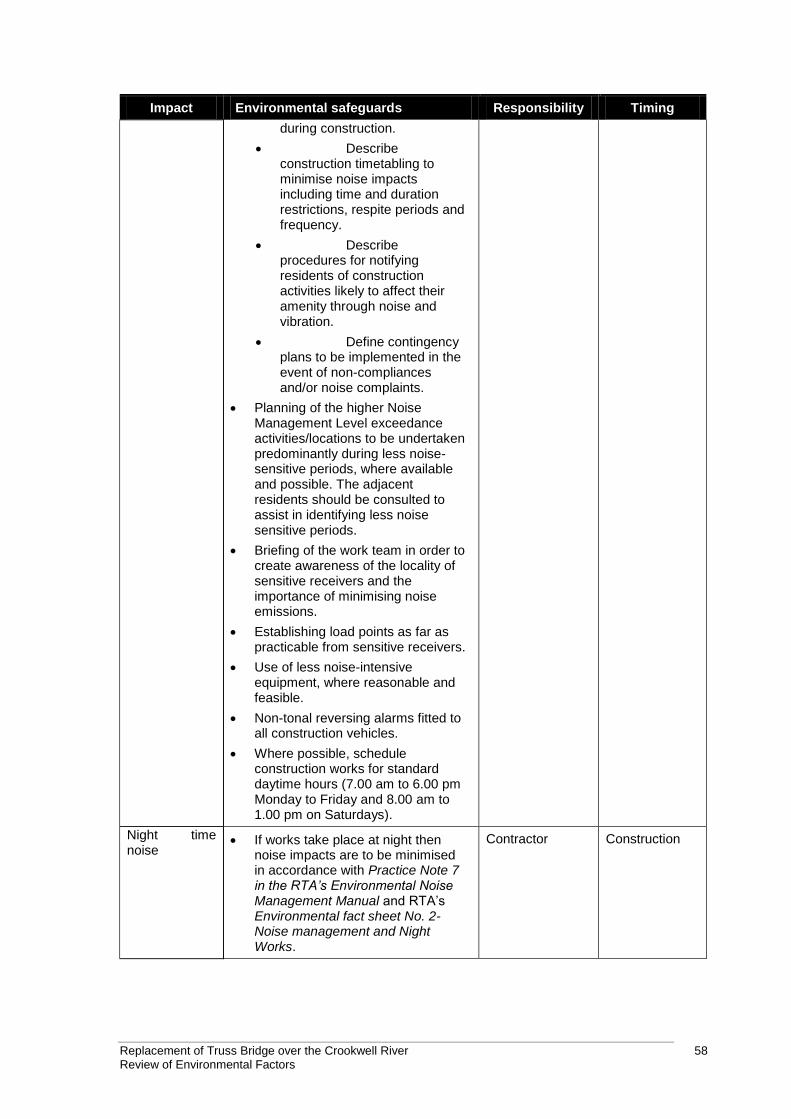
Replacement of Truss Bridge over the Crookwell River 58 Review of Environmental Factors
Impact Environmental safeguards Responsibility Timing
during construction.
Describe construction timetabling to minimise noise impacts including time and duration restrictions, respite periods and frequency.
Describe procedures for notifying residents of construction activities likely to affect their amenity through noise and vibration.
Define contingency plans to be implemented in the event of non-compliances and/or noise complaints.
Planning of the higher Noise Management Level exceedance activities/locations to be undertaken predominantly during less noise-sensitive periods, where available and possible. The adjacent residents should be consulted to assist in identifying less noise sensitive periods.
Briefing of the work team in order to create awareness of the locality of sensitive receivers and the importance of minimising noise emissions.
Establishing load points as far as practicable from sensitive receivers.
Use of less noise-intensive equipment, where reasonable and feasible.
Non-tonal reversing alarms fitted to all construction vehicles.
Where possible, schedule construction works for standard daytime hours (7.00 am to 6.00 pm Monday to Friday and 8.00 am to 1.00 pm on Saturdays).
Night time noise
If works take place at night then noise impacts are to be minimised in accordance with Practice Note 7 in the RTA’s Environmental Noise Management Manual and RTA’s Environmental fact sheet No. 2- Noise management and Night Works.
Contractor Construction
Replacement of Truss Bridge over the Crookwell River 59 Review of Environmental Factors
6.6 Visual
Clouston Associates carried out a landscape and visual impact assessment for the proposal (Clouston Associates 2013). This section summarises the report provided in Appendix E.
6.6.1 Methodology
The assessment was carried out in accordance with the Guidelines for Landscape Character and Visual Impact Assessment (RTA 2009). The impacts of the proposal were assessed in terms of:
Landscape Character Assessment - An analysis of the existing landscape that identifies landscape character zones according to their topography, drainage and urban form. Includes an assessment of likely impacts based on sensitivity and magnitude criteria.
Visual Impact Assessment - Identification and analysis of impacts of the proposal on key viewpoints.
The study area for the purposes of the assessment is shown in Figure 6-7.
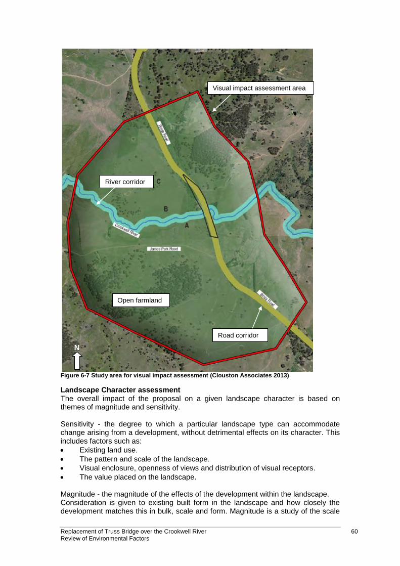
Replacement of Truss Bridge over the Crookwell River 60 Review of Environmental Factors
N
River corridor
Road corridor
Open farmland
Visual impact assessment area
Figure 6-7 Study area for visual impact assessment (Clouston Associates 2013)
Landscape Character assessment The overall impact of the proposal on a given landscape character is based on themes of magnitude and sensitivity. Sensitivity - the degree to which a particular landscape type can accommodate change arising from a development, without detrimental effects on its character. This includes factors such as:
Existing land use.
The pattern and scale of the landscape.
Visual enclosure, openness of views and distribution of visual receptors.
The value placed on the landscape. Magnitude - the magnitude of the effects of the development within the landscape. Consideration is given to existing built form in the landscape and how closely the development matches this in bulk, scale and form. Magnitude is a study of the scale
Replacement of Truss Bridge over the Crookwell River 61 Review of Environmental Factors
or degree of change to the landscape resource, the nature of the effect and its duration including whether it is permanent or temporary. Visual impact assessment The overall visual impact of the proposal is based on themes of magnitude and sensitivity. Sensitivity - each visual receptor type has an inherent and varied sensitivity to change in the visual scene based on their personal context in which the view is being experienced. This will have a direct bearing on the perception of visual impact experienced by the receptor and qualifies the quantitative impacts. Appendix E describes the levels of sensitivity for each receptor type. Magnitude - the magnitude of the visual effects of the development within the landscape. A series of quantitative assessments are studied, including distance from development, quantum of view, duration of view and magnitude of change. Appendix E describes the ratings assigned to these quantitative assessments. Overall Impact Rating The severity of landscape character and visual impacts are calculated using matrix Table 6-10 - based on a combination of magnitude and sensitivity. Table 6-10 Visual impact grading matrix
Magnitude
Sen
sit
ivit
y
High High to
moderate Moderate
Moderate to Low
Low Negligible
High High Impact High Impact Moderate-
High Moderate-
High Moderate Negligible
High to moderate
High Impact Moderate-
High Moderate-
High Moderate Moderate Negligible
Moderate Moderate-
High Moderate-
High Moderate Moderate
Moderate-Low
Negligible
Moderate to Low
Moderate-High
Moderate Moderate Moderate-
Low Moderate-
Low Negligible
Low Moderate Moderate Moderate-
Low Moderate-
Low Low Impact Negligible
Negligible
Negligible Negligible Negligible Negligible Negligible Negligible
6.6.2 Existing environment
The geography of the study area is characterised by undulating hillsides with cleared slopes and ridgelines which are typically covered with remnants of local vegetation communities. The study area is a river valley landscape, characterised by open hillsides and vegetated ridge lines. The predominant land use within the study is agricultural. Land is divided into allotments for grazing both sheep and cattle which has had a major influence on the surrounding landscape. Low density residential properties with warehousing and storage structures are found within the existing study area. Vegetation within the construction footprint is described as highly modified having been disturbed from previous clearing for agriculture and road development. Vegetation is largely exotic in origin, however, some specimens of native vegetation have been recorded.
Replacement of Truss Bridge over the Crookwell River 62 Review of Environmental Factors
Landscape character Three landscape character zones were established for the study area. Refer to Appendix E for a detailed description of each:
Open farmland.
Riparian corridor.
Road corridor. Refer to Figure 6-7 for map showing landscape character zones. Key viewpoints Seven key viewpoints were identified that have the potential to be visually impacted by the proposal. The locations identified are (refer to Figure 6-8):
1. Residential property north west of the existing bridge - A.
2. Residential property north east of the existing bridge - B.
3. Residential property south of the existing bridge- C.
4. Residential property south west of the existing bridge - D.
5. James Park Road looking north east.
6. Binda Road looking south.
7. Binda Road looking north.
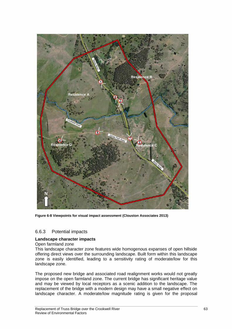
Replacement of Truss Bridge over the Crookwell River 63 Review of Environmental Factors
N
Residence D Residence C
Residence B
Residence A
Figure 6-8 Viewpoints for visual impact assessment (Clouston Associates 2013)
6.6.3 Potential impacts
Landscape character impacts Open farmland zone This landscape character zone features wide homogenous expanses of open hillside offering direct views over the surrounding landscape. Built form within this landscape zone is easily identified, leading to a sensitivity rating of moderate/low for this landscape zone.
The proposed new bridge and associated road realignment works would not greatly impose on the open farmland zone. The current bridge has significant heritage value and may be viewed by local receptors as a scenic addition to the landscape. The replacement of the bridge with a modern design may have a small negative effect on landscape character. A moderate/low magnitude rating is given for the proposal
Replacement of Truss Bridge over the Crookwell River 64 Review of Environmental Factors
within this character zone. The overall landscape character impact would therefore be moderate/low for this character zone. Riparian corridor This landscape character zone forms a distinctive edge to the Crookwell River. Some vegetation clearing will be required to the west of the existing bridge. Due to the intermittent distribution of vegetation within the corridor, this clearing will have little visual effect to the current landscape pattern. These factors lead to a moderate/low overall sensitivity rating. The bridge design will only have an impact on the riparian corridor immediately west of the existing bridge. The magnitude of the proposal within this landscape zone is limited due to the similarities of the proposed works to the existing elements and would not affect the character of this zone as a whole. The proposal is given a moderate/low magnitude rating within this landscape character zone. The overall landscape character impact would therefore be moderate/low for this character zone. Road corridor This landscape zone forms a distinctive linear corridor north south through the study area and includes the existing Crookwell River bridge. Development is limited to a single lane carriageway, associated road elements, safety and drainage features. This zone has a low overall sensitivity rating. The scale and bulk of the proposed development is of a similar magnitude to existing infrastructure elements within the study area. The current bridge does, however, have significant heritage value and may be viewed by receptors travelling along the road as a scenic addition to the landscape. The replacement of the bridge with a modern design may have a small negative effect on the landscape character of this zone. Therefore, the proposal is considered to have a moderate/low magnitude within this landscape zone. The overall landscape character impact would therefore be moderate/low for this character zone. Overall landscape character impact The removal of vegetation within the riparian corridor zone would be a permanent change to the landscape. The road corridor and open farmland zones can accommodate the proposal without any substantial change to their character given the limited nature of the new infrastructure. The loss of a heritage structure would, however, have some associated negative impacts and raises the overall landscape character rating from negligible to moderate/low. Visual impacts The visual impact viewpoints are shown in Figure 6-8. Table 6-11 provides a summary of the visual impact at each viewpoint. Table 6-11 Summary of visual impacts at each viewpoint
Viewpoint Construction impact
Construction impact rating
Operational impact Operational impact rating
1 Views of compound Moderate/high View of new bridge Moderate/low
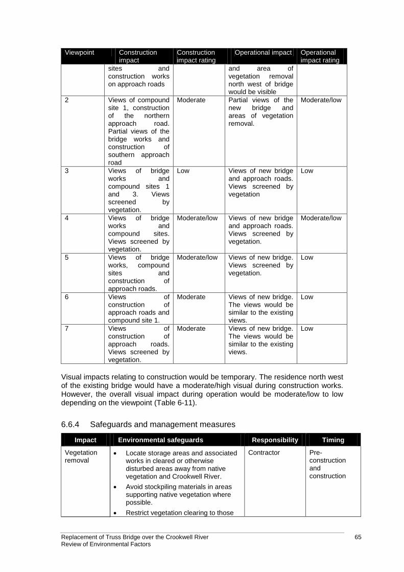
Replacement of Truss Bridge over the Crookwell River 65 Review of Environmental Factors
Viewpoint Construction impact
Construction impact rating
Operational impact Operational impact rating
sites and construction works on approach roads
and area of vegetation removal north west of bridge would be visible
2 Views of compound site 1, construction of the northern approach road. Partial views of the bridge works and construction of southern approach road
Moderate Partial views of the new bridge and areas of vegetation removal.
Moderate/low
3 Views of bridge works and compound sites 1 and 3. Views screened by vegetation.
Low Views of new bridge and approach roads. Views screened by vegetation
Low
4 Views of bridge works and compound sites. Views screened by vegetation.
Moderate/low Views of new bridge and approach roads. Views screened by vegetation.
Moderate/low
5 Views of bridge works, compound sites and construction of approach roads.
Moderate/low Views of new bridge. Views screened by vegetation.
Low
6 Views of construction of approach roads and compound site 1.
Moderate Views of new bridge. The views would be similar to the existing views.
Low
7 Views of construction of approach roads. Views screened by vegetation.
Moderate Views of new bridge. The views would be similar to the existing views.
Low
Visual impacts relating to construction would be temporary. The residence north west of the existing bridge would have a moderate/high visual during construction works. However, the overall visual impact during operation would be moderate/low to low depending on the viewpoint (Table 6-11).
6.6.4 Safeguards and management measures
Impact Environmental safeguards Responsibility Timing
Vegetation removal
Locate storage areas and associated works in cleared or otherwise disturbed areas away from native vegetation and Crookwell River.
Avoid stockpiling materials in areas supporting native vegetation where possible.
Restrict vegetation clearing to those
Contractor Pre-construction and construction
Replacement of Truss Bridge over the Crookwell River 66 Review of Environmental Factors
Impact Environmental safeguards Responsibility Timing
areas where it is necessary and opportunities to minimise clearing would be part of the detailed design.
Trim rather than removal of trees to be undertaken where possible, to be conducted by a qualified arborist.
Rehabilitate riparian areas according to the RTA Biodiversity Guidelines, 2011.
Areas to be revegetated would be planted with suitable native vegetation species.
Bridge construction
Bridge works would be managed in accordance with the RMS Bridge aesthetics guidelines, 2003.
Bridge detailed design (including steel safety barrier and abutments) to read as cohesive set of elements.
Proposed batter slopes would be 4:1 where possible, to assist in blending the proposal better within the landscape.
Proposed batter slopes should be planted with native grasses to reduce visual Impact and blend with landscape.
Choose finishes and materials based on limiting the amount of contrast with the surrounding landscape with the preferred use of muted colours
RMS Design
6.7 Traffic and Access
6.7.1 Existing environment
The truss bridge is on Binda Road, about 10km north of Crookwell. The road is a two-lane road but the road narrows to one lane over the existing bridge. Traffic coming from the north must yield to traffic from the south. This is indicated by ‘yield’ signs on either side of the road, approaching the bridge. Signs on both approaches to the bridge indicate that the road narrows ahead. The existing bridge cannot carry Higher Mass Limit (HML) vehicles. The current detour length for HML vehicles is 29 kilometres. Traffic counts taken during the noise assessment (SLR 2013) recorded a total of 618 vehicles per day crossing the bridge. This comprised of 542 motorist, cyclists and motorcyclists; 46 light goods vehicles and 30 heavy goods vehicles. The heavy goods vehicles accounted for about 5% of all vehicle movements.
6.7.2 Potential impacts
Construction The existing bridge would remain in operation while the new bridge and approach road is being constructed. There would be some temporary traffic delays when the
Replacement of Truss Bridge over the Crookwell River 67 Review of Environmental Factors
new approach roads are connected to the existing Binda Road. There would be traffic restrictions at the northern and the southern approach roads. Binda would be likely to be blocked for short periods (about 15 minutes) when traffic is switched from the old approach road to the new approach road. However, there would be no full road closures requiring detours at any time during construction. Access to private residents would be impacted during the construction of the approach roads however access to properties would be maintained throughout the construction phase. The new approach roads would be higher than the existing road. RMS would resurface and match the levels of access roads to the new road level. A new temporary access track would be constructed at the south west of the bridge to provide access to the rock platform for the piling rig. This would allow the piling rig to access the piers without having to try to clear the existing truss bridge. Operation The construction of a two-lane bridge would have positive impact for motorists. Motorists travelling from the north would no longer have to give way to those travelling from the south. The proposed two-lane bridge would be constructed to have capacity to carry HML vehicles. This would have a positive impact on the freight network.
6.7.3 Safeguards and management measures
Impact Environmental safeguards Responsibility Timing
Traffic and access
A Traffic Management Plan would be prepared and controls established at the site in accordance with RMS’s Traffic Controls at Work Sites.
Road users would be advised of the proposed work through Variable Message Signs (VMS).
Local residents would be notified in a timely manner prior to any works that may affect access to their property.
The temporary access track at the south west of the bridge would be removed and revegetated on completion of the works.
RMS and Contractor
Construction
6.8 Aboriginal heritage
Artefact carried out an assessment of Aboriginal heritage for the proposal (Artefact 2013). The Aboriginal Archaeological Survey Report (ASR) complies with Stage 2 of the RMS Procedure for Aboriginal Cultural Heritage Consultation and Investigation (PACHCI), as well as the Office of Environment and Heritage (OEH) regulations, including the Code of Practice for Archaeological Investigation of Aboriginal Objects in New South Wales 2010 (Code of Practice), and the Aboriginal Cultural Heritage Consultation Requirements for Proponents 2010. This section summarises the report provided in Appendix H.
Replacement of Truss Bridge over the Crookwell River 68 Review of Environmental Factors
6.8.1 Methodology
The study area for the Aboriginal heritage assessment includes the bridge and the immediate surrounding area (refer to Figure 6-9). Study area survey The survey was conducted on foot, with all areas of ground exposure examined for traces of Aboriginal occupation, and the landscape examined for evidence of disturbance or areas of potential archaeological sensitivity. No mature native trees remain in the study area and therefore cultural scarring or marking that may have been the work of Aboriginal people was not expected. A photographic record was kept to record different aspects of the landform units within the study area, vegetation, and levels of disturbance. Aboriginal community consultation Aboriginal consultation has been conducted in accordance with Stage 2 of the RMS PACHCI. A Native Title search indicated that there was a Native Title claim by Gundungurra Tribal Council Aboriginal Corporation (GTCAC) active within the study area. The study area is within the boundary of Pejar Local Aboriginal Land Council (PLALC). Representatives from PLALC and GTCAC were contacted by the RMS Aboriginal Cultural Heritage Advisor and were invited to participate in the Stage 2 PACHCI survey. Justin Boney from PLALC attended the site survey. Representatives from GTCAC were booked in for the site survey but did not attend on the day. PLALC has provided a site survey report which has been incorporated in the Aboriginal Heritage Assessment Report as an appendix. A copy of the final Aboriginal Heritage Assessment Report has been forwarded to PLALC and GTCAC for their information. No Aboriginal consultation under Stage 3 PACHCI is required by RMS. Predictive model A predictive model was developed for the study area, which used in the current study comprises a series of statements about the nature and distribution of evidence of Aboriginal land use that is expected in the study area. These statements are based on the information gathered regarding:
Landscape context and landform units.
Ethno historical evidence of Aboriginal land use.
Distribution of natural resources.
Results of previous archaeological work in the vicinity of the study area.
Predictive modelling proposed in previous investigations. Assessment of significance Archaeological significance refers to the archaeological or scientific importance of a landscape or area. This is characterised using archaeological criteria such as archaeological research potential, representativeness and rarity of the archaeological resource and potential for educational values. These are outlined below:
Research potential: does the evidence suggest any potential to contribute to an understanding of the area and/or region and/or state’s natural and cultural history?
Representativeness: how much variability (outside and/or inside the subject area) exists, what is already conserved, how much connectivity is there?
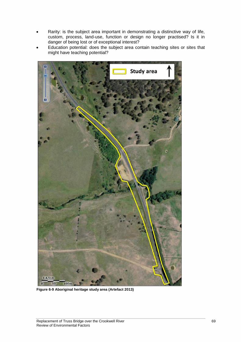
Replacement of Truss Bridge over the Crookwell River 69 Review of Environmental Factors
Rarity: is the subject area important in demonstrating a distinctive way of life, custom, process, land-use, function or design no longer practised? Is it in danger of being lost or of exceptional interest?
Education potential: does the subject area contain teaching sites or sites that might have teaching potential?
Figure 6-9 Aboriginal heritage study area (Artefact 2013)
Replacement of Truss Bridge over the Crookwell River 70 Review of Environmental Factors
6.8.2 Existing environment
Land use history The land surrounding Crookwell River Bridge was used for grazing from the early 19th century and has never been subject to development, apart from that associated with the road and river crossing. Some disturbance would have occurred through grazing, and the construction and maintenance of Binda Road and Crookwell River Bridge. The construction of the original road alignment would have disturbed land on either side of the current road alignment to the south of the bridge (including a strip of land around 5-15 metres wide to the east of the current road embankment, and a strip around 10-20 metres wide to the west of the current road embankment). The former road alignment would also have involved land disturbance to the north-west of the current bridge, between 20 and 50 metres from the present-day road. No details are known about the nature of the road’s construction, however, it is reasonable to assume that it would have involved some levelling and/or cutting, or the creation and subsequent removal of a road embankment. Either of these scenarios would have resulted in some degree of soil disturbance. The construction of the existing bridge and road alignment would have involved further disturbance to the river and river banks, and to land on either side of the bridge, including the creation of a road embankment built of fill to the south of the river and levelling to the north of the bridge. The land to the east of the bridge has also been affected by the diversion of the river, which occurred at some time before 1902 and has caused significant erosion. Aboriginal history in the area Aboriginal people traditionally lived in small family or clan groups that were associated with particular territories or places. According to the anthropologist Norman Tindale, Crookwell is located on the boundary of two major language groups: the Ngunawal to the west and the Gandangara to the east. There remains some uncertainty regarding which of the two groups occupied the study area. Aboriginal occupation of the area continued after European settlement, as shown by an account of conflict between two Aboriginal groups in 1851. Aboriginal Heritage Information System search An extensive Aboriginal Heritage Information System (AHIMS) search did not identify any previously recorded Aboriginal heritage sites. Predictive model The predictive model found that in the study area:
Stone artefacts/artefact scatters will be the most likely Aboriginal site type.
Artefact densities will be highest on lower hill slopes adjacent to watercourses.
Artefacts will be located in areas of least ground disturbance. Field study No previously recorded Aboriginal sites were located within or near the study area, and no previously unidentified Aboriginal sites were recorded during the field survey. The high levels of ground disturbance and landscape modification that were evident throughout most of the proposed development footprint during the survey, as well as the flood prone nature and shallow soils of the area surrounding the bridge indicate
Replacement of Truss Bridge over the Crookwell River 71 Review of Environmental Factors
that the study area has low potential for intact archaeological deposits associated with Aboriginal occupation. No areas of moderate or high archaeological potential were identified in or immediately adjacent to the study area. Assessment of significance The study area does not provide good research potential as there are no areas of archaeological potential to be investigated. Representativeness values are low within the study area and it is not rare within the local context. The area does not have potential to be used for education in Aboriginal heritage or archaeology. The study area is therefore assessed as having a low archaeological significance.
6.8.3 Potential impacts
The majority of the proposed works would occur in areas that have already been subject to considerable disturbance. The least disturbed area that would be affected is the narrow strip of land outside the road corridor to the west of Binda Road and south of the river, where the top soil would be stripped prior to the addition of fill. However, this area has been subject to some disturbance as the site of the former roadway and is located on a floodplain. It is therefore unlikely to contain any archaeological deposits associated with Aboriginal occupation and is of low archaeological potential. No Aboriginal sites, areas of particular cultural significance, or areas of archaeological potential would be impacted by the proposed development.
6.8.4 Safeguards and management measures
Impact Environmental safeguards Responsibility Timing
Destruction of Aboriginal heritage items
If Aboriginal heritage items are uncovered during the works, all works in the vicinity of the find must cease and the RTA’s Aboriginal cultural heritage advisor and the senior regional environmental officer contacted immediately. Steps in the RTA Standard Management Procedure: Unexpected Archaeological Finds must be followed.
Contractor and RMS
Construction
6.9 Air quality
6.9.1 Existing environment
The area is rural, with scattered residences and farm land surrounding the site. The major sources of air emissions within the Upper Lachlan Shire are domestic or commercial solvents and aerosols, and domestic solid fuel heaters. There are no facilities within the LGA that report air emissions to the National Pollutant Inventory (NPI) Upper Lachlan Shire Council 2013). There are four sensitive receivers in the area (refer to Table 6-12 and to Figure 6-6).
Replacement of Truss Bridge over the Crookwell River 72 Review of Environmental Factors
Table 6-12 Nearby sensitive receivers
Location Lot Brief Description
R1 115DP753012 About 230m from Binda Road. Residential, direct line of sight to bridge and approach from the south, northern approach partially shielded by earth mound
R2 1DP1035308 About 50m from Binda Road. Residential, direct line of sight to bridge, approaches partially shielded by topography
R3 42DP753012 About 400m west of Binda Road.
R4 1DP10404727 About 900m west of Binda Road
The main impact on air quality is likely to be from motor vehicles. However, air quality is likely to be good due to the low population density and relatively low traffic volumes.
6.9.2 Potential impacts
During proposed works there would be the potential for a localised deterioration in air quality due to dust and particulates generated from disturbed surfaces, in particular during earthworks and demolition of the existing bridge, and emissions from machinery and vehicles. Surfaces with lead paint would be managed under appropriate containment measures in accordance with (AS 4361.1) and therefore impacts are unlikely (refer to section 6.1). Impacts to air quality are likely to be minor and localised considering the scope of works and methodologies and the fact that sensitive receivers are located at a considerable distance from the proposal site.
6.9.3 Safeguards and management measures
Impact Environmental safeguards Responsibility Timing
Vehicle and other plant/equipment/machinery emissions
Well serviced vehicles, machinery and other plant or equipment is to be used in the proposal.
Vehicles would not be left running idle.
RMS and Contractor
Construction
Dust pollution Measures including watering/ progressive stabilisation of disturbed areas, or wrapping of bridge sections would be use to minimise air pollution
Visual surveillance for visible dust generation would occur at all times. Work would cease when high levels of airborne dust cannot be controlled.
Trucks transporting material to and from the proposal site would be covered at all times.
Contractor Construction
Removal of bridge
The removal of the bridge and lead contaminated material would be
Contractor Construction
Replacement of Truss Bridge over the Crookwell River 73 Review of Environmental Factors
Impact Environmental safeguards Responsibility Timing
undertaken in accordance with AS 4361.1 (CTI 2013).
6.10 Socio-economic
6.10.1 Existing environment
The area surrounding the bridge is sparsely populated, with the closest township being Crookwell, 10 kilometres to the south. Crookwell has a population of about 1900 people. The nearest regional centre is Goulburn, 55 kilometres to the south east. The existing bridge is not designed to carry Higher Mass Limit (HML) vehicles. The current detour length for HML vehicles is 29 kilometres. However, heavy vehicle currently use the bridge (refer to section 6.5). Four residential properties are located near the proposal site with access to Binda Road (Figure 6-6).
6.10.2 Potential impacts
The proposal would require partial land acquisitions as discussed in section 3.6. . The land is privately owned and crown land. RMS has identified and consulted with the affected private land owners. The land acquisition would be in accordance with the Land Acquisition (Just Terms Compensation) Act 1991 and the RMS Land acquisition information guide (RMS 2012c). The proposal would temporarily impact access to residences and would have some impacts on traffic. These impacts are discussed in section 6.7. The proposal would have some minor visual and noise impacts for road users. These impacts are discussed in sections 6.6 and 6.5 respectively. RMS would not require a full road closure at any time during the works. The works would have no impact on emergency services. The proposal would have a long term positive impact by providing a two-lane bridge that can carry Heavy Mass Load vehicles. The proposed bridge would include improved safety conditions at the locality as the risk associated with leaving the bridge in place would be removed. These risks include potential falling materials, bridge collapse and the presence of a dangerous substance in the form of flaking lead paint. The proposal would also remove any potential long term maintenance costs.
6.10.3 Safeguards and management measures
Impact Environmental safeguards Responsibility Timing
Local community
The landowner’s permission would be sought for access to land during the adjustments to private property
RMS Pre-construction and
Replacement of Truss Bridge over the Crookwell River 74 Review of Environmental Factors
Impact Environmental safeguards Responsibility Timing
access.
Community consultation would be undertaken by RMS in accordance with the RMS’s Community Involvement Practice Notes and Resource Manual.
RMS would establish appropriate modes of communication for the receipt of complaints from stakeholders on the proposal.
Complaints received would be recorded and attended to promptly in accordance with the RMS’s Community Involvement Practice Notes and Resource Manual.
RMS would provide regular updates on the proposal at their website and when appropriate through advertisements in newspapers, variable message signs and letterbox drop-offs.
construction
6.11 Waste
6.11.1 Policy setting
Waste management would be undertaken in accordance with the Waste Avoidance and Resource Recovery Act 2001. The objectives of this Act that are applicable to the proposal are:
(a) to encourage the most efficient use of resources and to reduce environmental harm in accordance with the principles of ecologically sustainable development,
(b) to ensure that resource management options are considered against a hierarchy of the following order:
(i) avoidance of unnecessary resource consumption,
(ii) resource recovery (including reuse, reprocessing, recycling and energy recovery),
(iii) disposal,
(c) to provide for the continual reduction in waste generation,
(d) to minimise the consumption of natural resources and the final disposal of waste by encouraging the avoidance of waste and the reuse and recycling of waste,
(e) to assist in the achievement of the objectives of the Protection of the Environment Operations Act 1997.
6.11.2 Potential impacts
The proposed works would generate waste from the following sources.
Steel parts of the existing bridge that are coated with lead paint.
Potentially treated (e.g. Copper Chromium Arsenic) timber from the bridge.
Grass, shrubs and tree cuttings from vegetation clearing.
Replacement of Truss Bridge over the Crookwell River 75 Review of Environmental Factors
Potentially contaminated soil from lead paint flakes from the bridge.
General waste.
Waste would be temporarily stored on site prior to disposal at an appropriately licensed waste facility. There is potential for lead paint on bridge parts to flake off and contaminate soil.
6.11.3 Safeguards and management measures
Impact Environmental safeguards Responsibility Timing
Production of packaging materials and other construction waste.
The resource management hierarchy would be followed at all times throughout the proposal:
avoid resource consumption → recover recyclable materials for reuse → dispose material unable to be recycled
Any bridge parts with lead paint requiring temporary storage prior to disposal would be stored in bunded areas.
Steel bridge parts with lead paint would be removed from the bridge in accordance with Guide to Lead Paint Management – Part 1 Industrial Applications 1995 and disposed of at an appropriately licensed waste facility.
RMS would survey the bridge for treated timber prior to the start of any demolition work.
Timber that has been treated would be disposed of at an appropriately licensed waste facility.
Any contaminated soil would be stored in a bunded area and disposed of at an appropriately licensed waste facility.
There would be no disposal or re-use of construction waste on to other land.
Waste would not to be burnt on site.
Waste material would not be left on site once the works have been completed.
Working areas would be maintained, kept free of rubbish and cleaned up at the end of each working day.
RMS and contractor.
Pre-construction and construction
Production of garden organics materials
The cleared vegetation would be reused on site or disposed of at a facility licensed to receive garden organics materials.
Noxious weeds would be disposed of according to relevant guidelines.
RMS and contractor.
Pre-construction and construction
Replacement of Truss Bridge over the Crookwell River 76 Review of Environmental Factors
Impact Environmental safeguards Responsibility Timing
Production of solid putrescibles waste
Proper bins (with lids) would be available for the temporary storage of putrescible waste within the site compound and then disposed of by a licensed contractor.
RMS and contractor.
Construction
6.12 Cumulative impacts
RMS is not aware of any other existing or future developments in the area that the proposal could interact with and result in a cumulative impact. The cumulative impacts of the destruction of a de Burgh Truss Bridge was assessed to be low (section 6.4), nghenvironmental 2013b). RMS would maintain five examples of this type of bridge, therefore the destruction of this bridge would only have a minor cumulative heritage impact. The proposed works would improve freight transport with other similar works as part of the Bridges for the Bush Initiative.
6.13 Summary of beneficial effects
The benefits of the proposal would be:
Provision of a two-lane bridge to replace the existing single lane structure.
Improvement to the freight network.
Reduction in ongoing maintenance costs.
Improvements to Crookwell River bank stability.
6.14 Summary of adverse effects
The adverse impacts of the proposal would be:
Demolition of a historic bridge.
Removal of an estimated 1.1 ha of vegetation.
Potential to impact water quality of the Crookwell River and to impact
aquatic habitats.
Temporary noise impacts to four residential properties.
Replacement of Truss Bridge over the Crookwell River 77 Review of Environmental Factors
7 Environmental management
7.1 Environmental management plans (or system)
A number of safeguards and management measures have been identified in order to minimise adverse environmental impacts, including social impacts, which could potentially arise as a result of the proposal. Should the proposal proceed, these management measures would be incorporated into the detailed design and applied during the construction and operation of the proposal. A Project Environmental Management Plan (PEMP) and a Contractors Environmental Management Plan (CEMP) will be prepared to describe safeguards and management measures identified. These plans will provide a framework for establishing how these measures will be implemented and who would be responsible for their implementation. The plans will be prepared prior to construction of the proposal and must be reviewed and certified by the Roads and Maritime Services Environmental Officer, Southern Region, prior to the commencement of any on-site works. The CEMP will be a working document, subject to ongoing change and updated as necessary to respond to specific requirements. The CEMP and PEMP would be developed in accordance with the specifications set out in the QA Specification G36 – Environmental Protection (Management System), QA Specification G38 – Soil and Water Management (Soil and Water Plan) and the QA Specification G40 – Clearing and Grubbing].
7.2 Summary of safeguards and management measures
Environmental safeguards outlined in this document would be incorporated into the detailed design phase of the proposal and during construction and operation of the proposal, should it proceed. These safeguards would minimise any potential adverse impacts arising from the proposed works on the surrounding environment. The safeguards and management measures are summarised in Table 7-1.
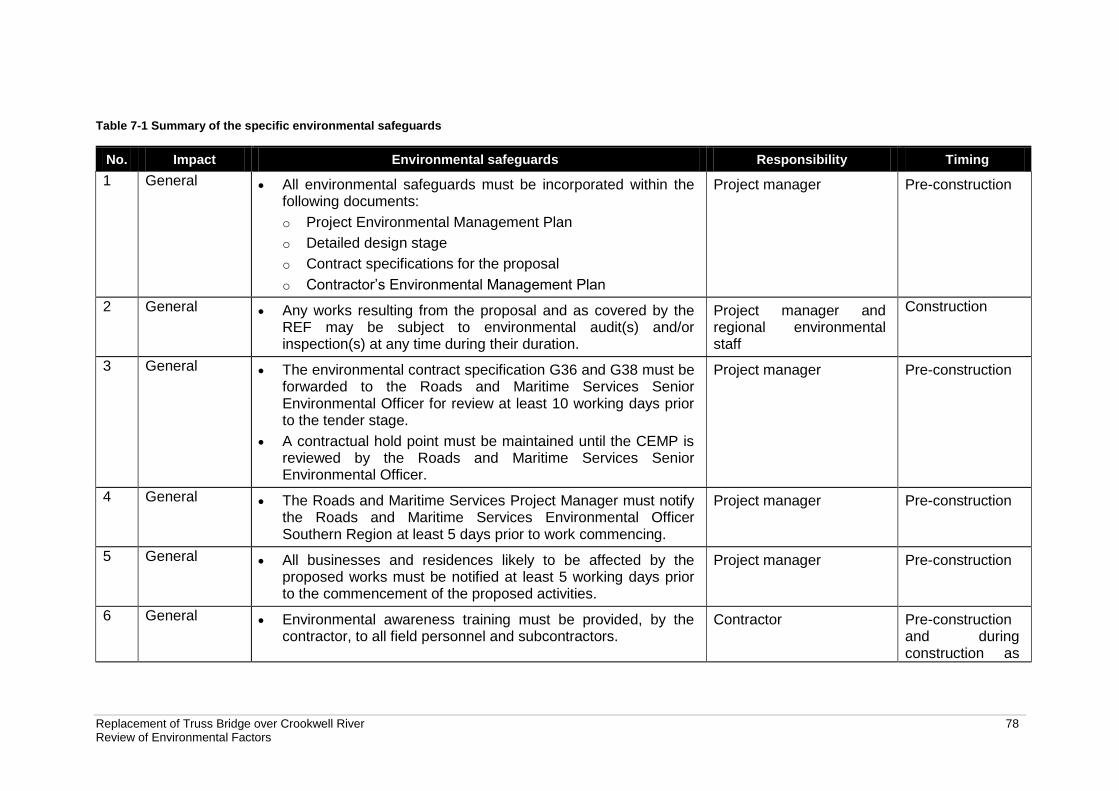
Replacement of Truss Bridge over Crookwell River 78 Review of Environmental Factors
Table 7-1 Summary of the specific environmental safeguards
No. Impact Environmental safeguards Responsibility Timing
1 General All environmental safeguards must be incorporated within the following documents: o Project Environmental Management Plan o Detailed design stage o Contract specifications for the proposal o Contractor’s Environmental Management Plan
Project manager Pre-construction
2 General Any works resulting from the proposal and as covered by the REF may be subject to environmental audit(s) and/or inspection(s) at any time during their duration.
Project manager and regional environmental staff
Construction
3 General The environmental contract specification G36 and G38 must be forwarded to the Roads and Maritime Services Senior Environmental Officer for review at least 10 working days prior to the tender stage.
A contractual hold point must be maintained until the CEMP is reviewed by the Roads and Maritime Services Senior Environmental Officer.
Project manager Pre-construction
4 General The Roads and Maritime Services Project Manager must notify the Roads and Maritime Services Environmental Officer Southern Region at least 5 days prior to work commencing.
Project manager Pre-construction
5 General All businesses and residences likely to be affected by the proposed works must be notified at least 5 working days prior to the commencement of the proposed activities.
Project manager Pre-construction
6 General Environmental awareness training must be provided, by the contractor, to all field personnel and subcontractors.
Contractor Pre-construction and during construction as
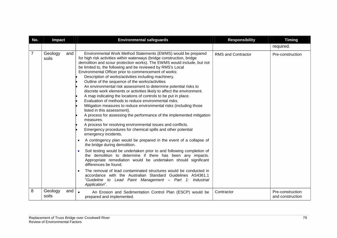
Replacement of Truss Bridge over Crookwell River 79 Review of Environmental Factors
No. Impact Environmental safeguards Responsibility Timing
required.
7 Geology and soils
Environmental Work Method Statements (EWMS) would be prepared for high risk activities within waterways (bridge construction, bridge demolition and scour protection works). The EWMS would include, but not be limited to, the following and be reviewed by RMS's Local Environmental Officer prior to commencement of works:
Description of works/activities including machinery.
Outline of the sequence of the works/activities
An environmental risk assessment to determine potential risks to discrete work elements or activities likely to affect the environment.
A map indicating the locations of controls to be put in place.
Evaluation of methods to reduce environmental risks.
Mitigation measures to reduce environmental risks (including those listed in this assessment).
A process for assessing the performance of the implemented mitigation measures.
A process for resolving environmental issues and conflicts.
Emergency procedures for chemical spills and other potential emergency incidents.
A contingency plan would be prepared in the event of a collapse of the bridge during demolition.
Soil testing would be undertaken prior to and following completion of the demolition to determine if there has been any impacts. Appropriate remediation would be undertaken should significant differences be found.
The removal of lead contaminated structures would be conducted in accordance with the Australian Standard Guidelines AS4361.1 “Guideline to Lead Paint Management – Part 1: Industrial Application”.
RMS and Contractor Pre-construction
8 Geology and soils
An Erosion and Sedimentation Control Plan (ESCP) would be prepared and implemented.
Contractor Pre-construction and construction
Replacement of Truss Bridge over Crookwell River 80 Review of Environmental Factors
No. Impact Environmental safeguards Responsibility Timing
Erosion and sediment controls would be maintained regularly until the proposed works are completed (including the removal of any built up soils and materials).
Only the minimal amount of vegetation would be removed for access. Where trees need to be removed, preference would be made to keep the root in place.
Access to the waterway would be via two access tracks, the existing disturbed area to the southeast of the bridge, and a new track on the western side of the bridge. All other areas would be designated as no go zones to avoid disturbance of the banks.
During rehabilitation, stabilise the banks of the waterway through revegetation and/or armouring according to a landscape plans.
9 Geology and soils
Spill kits are to be kept on all machinery with operators trained with how to use them.
Response to spills to be discussed during toolbox meetings.
All debris created by the demolition work is to be fully contained by use of drop nets and shade cloth to prevent spreading of paint debris entering the waterway.
All re-fuelling of vehicles and equipment would be undertaken in an impervious bunded area at the compound site. The location of the refuelling bund would be located 40 metres from the top of the bank of the Crookwell River and away from the unnamed tributary.
The refuelling of the crane and/or drilling rig which would be located in proximity of the bank would be undertaken in an impervious double bund.
In the event of a spill or paint contamination of the waterway, works would cease and an RMS Environmental Officer be contacted immediately. Any potential contamination of the waterway would be reported to the EPA immediately.
The use of a silt curtain should be considered to minimise potential
Contractor Pre-construction and construction
Replacement of Truss Bridge over Crookwell River 81 Review of Environmental Factors
No. Impact Environmental safeguards Responsibility Timing
downstream impacts during construction of the new bridge, demolition of existing bridge and scour protection works. A risk assessment should be undertaken prior to use to ensure the use of the silt curtain would not cause more disturbance than the proposed construction activity. The silt curtain should be used in such a way as not to restrict fish passage.
10 Geology and soils
Access would be via existing access tracks where possible to minimise potential erosion susceptibility. Access tracks would be overlaid with geofabric and road base material.
RMS and Contractor Pre-construction and construction
11 Non-Aboriginal heritage
RMS notifies the NSW Heritage Branch (OEH) not less than 14 days prior to any works commencing to remove the s.170 listed bridge. It is a statutory requirement under s.170 that a delisting process with the NSW State Heritage Office be undertaken when transferring or demolishing items listed on an s.170 register.
Under Section 14 of the SEPP (Infrastructure) RMS would provide written notice of the intention to carry out the proposed works, with a copy of this SoHI to the Upper Lachlan Shire Council.
Archival photographic recording of the Truss Bridge over Crookwell River would be completed prior to demolition works.
As there are not many remaining examples of the de Burgh type truss bridge in NSW, the bridge should be included in the proposed RMS Interpretation Strategy/publication.
Demolition of the Crookwell River Bridge should follow the requirements in the RMS Recycling of Used Bridge Timbers policy. All useful parts of the bridges should be salvaged and stockpiled for possible future use.
Contractor and RMS Pre-construction and construction
12 Non-Aboriginal heritage
If unexpected archaeological remains are uncovered during the works, all works must cease in the vicinity of the material/find and the steps in the RTA Standard Management Procedure: Unexpected Archaeological Finds must be followed. Roads and Maritime Services Senior Regional Environmental Officer must be contacted
Replacement of Truss Bridge over Crookwell River 82 Review of Environmental Factors
No. Impact Environmental safeguards Responsibility Timing
immediately.
If any items defined as relics under the NSW Heritage Act 1977 are uncovered during the works, all works must cease in the vicinity of the find and the Roads and Maritime Services Senior Regional Environmental Officer contacted immediately.
13 Biodiversity Prior to the commencement of works a physical vegetation clearing boundary is to be demarcated and implemented to prevent accidental over clearing. The delineation of such a boundary may include the use of flagging tape, parawebbing or similar.
All vegetation removal is to be done in accordance with the RTA Biodiversity Guidelines – Protecting and Managing Biodiversity on RTA Projects (RTA 2011).
Where possible, mature vegetation should be avoided to maintain habitat connectivity and bank stability.
Areas already impacted by previous clearing or disturbance should be preferentially utilised over undisturbed areas or where native vegetation is present.
Revegetation of the site with locally occurring native flora species typical of the original riparian habitat will improve habitat for both native and threatened species which have the potential to occur in the area.
Contractor Pre-construction and construction
14 Biodiversity A pre-clearing survey for roosting microbats will be conducted by a suitably qualified ecologist immediately prior to the demolition of the bridge.
If microbats are found during the preclearing survey, an ecologist would be present during the demolition of the bridge to capture any additional bats.
Fauna handling must be carried out in accordance with the requirements the RTA Biodiversity Guidelines - Guide 9 (Fauna Handling).
Contractor Pre-construction
Replacement of Truss Bridge over Crookwell River 83 Review of Environmental Factors
No. Impact Environmental safeguards Responsibility Timing
If unexpected threatened fauna or flora species are discovered, stop works immediately and follow the RTA Unexpected Threatened Species Find Procedure in the RTA Biodiversity Guidelines 2011 – Guide 1 (Pre-clearing process).
15 Biodiversity The requirements of the Noxious Weeds Act 1993 will be followed, and any weed removal activities should follow Guide 6 (Weed Management) in the RMS Biodiversity Guidelines, the Noxious Weeds Act 1993 and the Upper Lachlan Shire Council Noxious Weeds Policy (2009).
The contractor is to prepare and implement a machinery hygiene protocol. Machinery would be cleaned prior to entering the site to ensure that weed seeds and propagules are not imported to the site.
Particular care should be taken when trimming or removing Willows, as these species are notorious for being difficult to fully remove from the site due to their ability to reproduce vegetatively.
Contractor Pre-construction and construction
16 Biodiversity The proposed works should follow the best practice hygiene guidelines in the RMS Biodiversity Guidelines (Guide 7: Pathogen Management) to prevent their introduction or spread.
Contractor Pre-construction and construction
17 Biodiversity The proposed development will be undertaken within the riparian zone of the Crookwell River. As such, the works should follow Guide 10 (Aquatic Habitats and Riparian Zones) in the RMS Biodiversity Guidelines to minimise potential impacts. Considerations relevant to the proposal will include clearing of riparian vegetation and site rehabilitation.
Contractor Pre-construction and construction
18 Biodiversity DPI (fisheries) should be notified of the proposed reclamation as part of the works under section 198 of the Fisheries Management Act 1994.
Should any fish kills occur during construction, all works would stop and DPI (Fisheries) and the RMS local environmental officer would be contacted immediately.
Contractor and RMS Construction
Replacement of Truss Bridge over Crookwell River 84 Review of Environmental Factors
No. Impact Environmental safeguards Responsibility Timing
Construction methods within the waterway should ensure that the free passage of fish downstream and upstream is maintained at all times.
The use of a silt curtain should be considered to minimise potential downstream impacts. A risk assessment should be undertaken prior to use to ensure the use of the silt curtain would not cause more disturbance than the proposed construction activity. The silt curtain should be used in such a way as not to restrict fish passage.
19 Biodiversity Where instream works cannot be avoided, the instream works footprint should be minimised as to avoid impacts to instream vegetation and fish habitat.
Removal of instream habitat structures such as boulders, vegetation and large woody debris, should be avoided where possible. Any relocation/removal would be done in consultation with DPI Fisheries
The design and location of the bridge piles should ensure that any modification to local hydrology as a result of these would not cause bank erosion or encourage sediment build-up around the structure.
If feasible, instream works with a high potential to impact water quality (e.g. piling activities) should be avoided during the breeding period of aquatic species (spring/summer).
Contractor and RMS Pre-construction and construction
20 Hydrology and flooding
The bridge piles would be designed to minimise potential hydrological impacts which could lead to erosion and sedimentation.
RMS Design
21 Hydrology and flooding
A contingency plan would be prepared in the event of a collapse of the bridge during demolition.
Proposed instream works would be undertaken during periods of low flow.
A Flood Contingency Plan would be prepared to identify any potential
flood threats and the evacuation procedure for dispersible materials,
hazardous materials and equipment containing hazardous or
dispersible materials. The Flood Contingency Plan would address:
RMS and Contractor Pre-construction and construction
Replacement of Truss Bridge over Crookwell River 85 Review of Environmental Factors
No. Impact Environmental safeguards Responsibility Timing
o Daily weather and flood monitoring
o Number of workers required to implement the Plan and their
availability to undertake the Plan at short notice.
o List of all equipment to be removed from the site.
o Methodology for the removal of construction plant, in particular any
construction plant that may be located in the river.
o Detail who would be responsible for monitoring the flood threat and
how is this to be done. It is expected that flood warning information
would be sourced from the BoM website.
o Detail staff training requirements and roles and responsibilities for
the implementation of the Plan.
22 Noise and vibration
A site specific Construction Noise and Vibration Management Pan (CNVMP) would be prepared
Assist in ensuring that the noise emissions during the construction works comply with the noise management levels and goals.
Determine noise and vibration monitoring, reporting and response procedures.
Describe specific mitigation treatments, management methods and procedures to be implemented to control noise and vibration during construction.
Describe construction timetabling to minimise noise impacts including time and duration restrictions, respite periods and frequency.
Describe procedures for notifying residents of
Contractor Construction
Replacement of Truss Bridge over Crookwell River 86 Review of Environmental Factors
No. Impact Environmental safeguards Responsibility Timing
construction activities likely to affect their amenity through noise and vibration.
Define contingency plans to be implemented in the event of non-compliances and/or noise complaints.
Planning of the higher Noise Management Level exceedance activities/locations to be undertaken predominantly during less noise-sensitive periods, where available and possible. The adjacent residents should be consulted to assist in identifying less noise sensitive periods.
Briefing of the work team in order to create awareness of the locality of sensitive receivers and the importance of minimising noise emissions.
Establishing load points as far as practicable from sensitive receivers.
Use of less noise-intensive equipment, where reasonable and feasible.
Non-tonal reversing alarms fitted to all construction vehicles.
Where possible, schedule construction works for standard daytime hours (7.00 am to 6.00 pm Monday to Friday and 8.00 am to 1.00 pm on Saturdays).
23 Noise and vibration
If works take place at night then noise impacts are to be minimised in accordance with Practice Note 7 in the RTA’s Environmental Noise Management Manual and RTA’s Environmental fact sheet No. 2- Noise management and Night Works.
Contractor Construction
24 Visual Locate storage areas and associated works in cleared or otherwise disturbed areas away from native vegetation and Crookwell River.
Avoid stockpiling materials in areas supporting native vegetation where possible.
Restrict vegetation clearing to those areas where it is necessary and opportunities to minimise clearing would be part of the detailed
Contractor Pre-construction and construction
Replacement of Truss Bridge over Crookwell River 87 Review of Environmental Factors
No. Impact Environmental safeguards Responsibility Timing
design.
Trim rather than removal of trees to be undertaken where possible, to be conducted by a qualified arborist.
Rehabilitate riparian areas according to the RTA Biodiversity Guidelines, 2011.
Areas to be revegetated would be planted with suitable native vegetation species.
25 Visual Bridge works would be managed in accordance with the RMS Bridge aesthetics guidelines, 2003.
Bridge detailed design (including steel safety barrier and abutments) to read as cohesive set of elements.
Proposed batter slopes would be 4:1 where possible, to assist in blending the proposal better within the landscape.
Proposed batter slopes should be planted with native grasses to reduce visual Impact and blend with landscape.
Choose finishes and materials based on limiting the amount of contrast with the surrounding landscape with the preferred use of muted colours
RMS Design
26 Traffic and access
A Traffic Management Plan would be prepared and controls established at the site in accordance with RMS’s Traffic Controls at Work Sites.
Road users would be advised of the proposed work through Variable Message Signs (VMS).
Local residents would be notified in a timely manner prior to any works that may affect access to their property.
The temporary access track at the south west of the bridge would be removed and revegetated on completion of the works.
RMS and Contractor Construction
27 Aboriginal heritage
If Aboriginal heritage items are uncovered during the works, all works in the vicinity of the find must cease and the RTA’s Aboriginal cultural
Contractor and RMS Construction
Replacement of Truss Bridge over Crookwell River 88 Review of Environmental Factors
No. Impact Environmental safeguards Responsibility Timing
heritage advisor and the senior regional environmental officer contacted immediately. Steps in the RTA Standard Management Procedure: Unexpected Archaeological Finds must be followed.
28 Air quality Well serviced vehicles, machinery and other plant or equipment is to be used in the proposal.
Vehicles would not be left running idle.
RMS and Contractor Construction
29 Air quality Measures including watering/ progressive stabilisation of disturbed areas, or wrapping of bridge sections would be use to minimise air pollution
Visual surveillance for visible dust generation would occur at all times. Work would cease when high levels of airborne dust cannot be controlled.
Trucks transporting material to and from the proposal site would be covered at all times.
Contractor Construction
30 Air quality The removal of the bridge and lead contaminated material would be undertaken in accordance with AS 4361.1 (CTI 2013).
Contractor Construction
31 Socio-economic
The landowner’s permission would be sought for access to land during the adjustments to private property access.
Community consultation would be undertaken by RMS in accordance with the RMS’s Community Involvement Practice Notes and Resource Manual.
RMS would establish appropriate modes of communication for the receipt of complaints from stakeholders on the proposal.
Complaints received would be recorded and attended to promptly in accordance with the RMS’s Community Involvement Practice Notes and Resource Manual.
RMS would provide regular updates on the proposal at their website and when appropriate through advertisements in newspapers,
RMS Pre-construction and construction
Replacement of Truss Bridge over Crookwell River 89 Review of Environmental Factors
No. Impact Environmental safeguards Responsibility Timing
variable message signs and letterbox drop-offs.
32 Waste The resource management hierarchy would be followed at all times throughout the proposal:
avoid resource consumption → recover recyclable materials for reuse → dispose material unable to be recycled
Any bridge parts with lead paint requiring temporary storage prior to disposal would be stored in bunded areas.
Steel bridge parts with lead paint would be removed from the bridge in accordance with Guide to Lead Paint Management – Part 1 Industrial Applications 1995 and disposed of at an appropriately licensed waste facility.
RMS would survey the bridge for treated timber prior to the start of any demolition work.
Timber that has been treated would be disposed of at an appropriately licensed waste facility.
Any contaminated soil would be stored in a bunded area and disposed of at an appropriately licensed waste facility.
There would be no disposal or re-use of construction waste on to other land.
Waste would not to be burnt on site.
Waste material would not be left on site once the works have been completed.
Working areas would be maintained, kept free of rubbish and cleaned up at the end of each working day.
RMS and contractor. Pre-construction and construction
33 Waste The cleared vegetation would be reused on site or disposed of at a facility licensed to receive garden organics materials.
Noxious weeds would be disposed of according to relevant guidelines.
RMS and contractor. Pre-construction and construction
Replacement of Truss Bridge over Crookwell River 90 Review of Environmental Factors
No. Impact Environmental safeguards Responsibility Timing
34 Waste Proper bins (with lids) would be available for the temporary storage of putrescible waste within the site compound and then disposed of by a licensed contractor.
RMS and contractor. Construction
Replacement of Truss Bridge over Crookwell River 91 91 Review of Environmental Factors
7.3 Licensing and approvals
A license under Part 7 of the Fisheries Management Act 1994 would be required should fish passage need to be temporarily blocked during construction. Clause 14 of the ISEPP requires that consultation with local council must occur when a development has the potential to impact on a local heritage item when this impact is likely to not be minor or inconsequential to the local heritage item. Crookwell River Bridge is considered to be a heritage item of local significance under Schedule 5 of the Upper Lachlan Shire LEP. Under Clause 14 the public authority undertaking the development must assess the impact on the item, provide the local council with written notice to carry out the development with a copy of the Statement of Heritage Impacts and consider any response to the notice received from the council regarding the proposal within 21 days of receiving the notice. RMS would undertake a delisting process with the Heritage Branch because it is a statutory requirement when demolishing items listed on a section 170 register. Under clause 199 of the Fisheries Management Act 1994, RMS is required to give notice to DPI (Fisheries) NSW and consider any comments received within 28 days for proposed dredging and reclamation works.
Replacement of Truss Bridge over Crookwell River 92 92 Review of Environmental Factors
8 Conclusion
8.1 Justification
The proposal would provide a two-lane bridge that would improve the freight network and provide improved driving conditions for motorists. The proposal would also result in reduced maintenance costs. The REF has determined that impacts caused by the proposal to the environment would generally be minor and mostly temporary with the implementation of the recommended safeguards. The proposed works are considered justified as they would meet all objectives of the proposal with mostly minor environmental impacts.
8.2 Objects of the EP&A Act
Object Comment
5(a)(i) To encourage the proper management, development and conservation of natural and artificial resources, including agricultural land, natural areas, forests, minerals, water, cities, towns and villages for the purpose of promoting the social and economic welfare of the community and a better environment.
The replacement and demolition of Crookwell Bridge would meet the objectives of the proposal, notably the removal of safety concerns, removed costs due to ongoing maintenance and improved conditions of the freight network and driving conditions. These objectives can be considered valuable to the community as they provide for a safer environment.
5(a)(ii) To encourage the promotion and co-ordination of the orderly economic use and development of land.
The proposal would improve the freight network in NSW in accordance with the ‘bridges for the bush’ initiatives.
5(a)(iii) To encourage the protection, provision and co-ordination of communication and utility services.
Not relevant to the project.
5(a)(iv) To encourage the provision of land for public purposes.
Not relevant to the project.
5(a)(v) To encourage the provision and co-ordination of community services and facilities.
Not relevant to the project.
5(a)(vi) To encourage the protection of the environment, including the protection and conservation of native animals and plants, including threatened species, populations and ecological communities, and their habitats.
The proposal would result in the removal of 1.1 ha of vegetation, mostly exotic species. The proposal is not likely to have significant impacts to native animals and plants, including threatened species, populations and ecological communities, and their habitats. This is discussed in more detail in section 6.3.
5(a)(vii) To encourage ecologically sustainable development.
Ecologically sustainable development is considered in Sections 8.2.1 – 8.2.4 below.
5(a)(viii) To encourage the provision and maintenance of affordable housing.
Not relevant to the project.
5(b) To promote the sharing of the responsibility for environmental planning
Not relevant to the project.
Replacement of Truss Bridge over Crookwell River 93 93 Review of Environmental Factors
Object Comment
between different levels of government in the State.
5(c) To provide increased opportunity for public involvement and participation in environmental planning and assessment.
Public consultation has occurred in the form of reviewing previous RMS reports such as the Roads and Maritime Services Timber Truss Bridge Conservation Strategy, Submissions report and revised conservation strategy (RMS 2012). Consultation with government agencies and authorities has occurred (Section 5).
8.2.1 The precautionary principle
The precautionary principle has been adopted during the preparation of the REF. Detailed design of the proposal would ensure that no serious or irreversible environmental harm would arise from the demolition activities. Operational safeguards would be implemented to minimise or mitigate any potential impacts and provide a high degree of certainty that no significant environmental impacts would occur as a result of the proposal.
8.2.2 Intergenerational equity
The proposal would not adversely impact on the environment such that it would compromise the health, diversity or productivity of the environment to unsustainable levels that subsequently would impact on the present and future generations. The proposal would improve the safety of Binda Road and improve the freight network. While some negative impacts would result through the removal of a heritage listed bridge, the removal is consistent with the Timber Truss Bridge Conservation Strategy – Submissions Report and Revised Conservation Strategy (RMS 2012). Bridges of a similar type as the Crookwell River Bridge would be retained in NSW.
8.2.3 Conservation of biological diversity and ecological integrity
Section 6.3 discussed the potential impacts of the proposal on biodiversity. The proposal would require the removal of some vegetation which is mostly composed of exotic species including weeds. The proposal is unlikely to impact on the biological diversity and ecological integrity of the site.
8.2.4 Improved valuation, pricing and incentive mechanisms
The removal of the existing bridge would reduce ongoing maintenance costs that are required for the upkeep of the bridge. Improvements to the freight network would also have economic benefits.
8.3 Conclusion
The proposed replacement of the truss bridge over Crookwell River, 10 kilometres north of Crookwell is subject to assessment under Part 5 of the EP&A Act. The REF has examined and taken into account to the fullest extent possible all matters affecting or likely to affect the environment by reason of the proposed activity. This has included consideration of conservation agreements and plans of management under the NPW Act, joint management and biobanking agreements under the TSC Act, wilderness areas, critical habitat, impacts on threatened species, populations and ecological communities and their habitats and other protected fauna and native
Replacement of Truss Bridge over Crookwell River 94 94 Review of Environmental Factors
plants. A number of potential environmental impacts from the proposal have been avoided or reduced during the concept design development and options assessment. The proposal as described in the REF best meets the project objectives but would still result in some impacts on vegetation and non-Aboriginal heritage. Mitigation measures as detailed in this REF would ameliorate or minimise some of these expected impacts. The proposal would also improve the freight network, provide safer access to the bridge and reduce ongoing maintenance costs. On balance the proposal is considered justified. The environmental impacts of the proposal are not likely to be significant and therefore it is not necessary for an environmental impact statement to be prepared and approval to be sought for the proposal from the Minister for Planning under Part 5.1 of the EP&A Act. The proposal is unlikely to affect threatened species, populations or ecological communities or their habitats, within the meaning of the Threatened Species Conservation Act 1995 or Fisheries Management Act 1994 and therefore a Species Impact Statement is not required. The proposal is also unlikely to affect Commonwealth land or have an impact on any matters of national environmental significance.
Replacement of Truss Bridge over Crookwell River 95 95 Review of Environmental Factors
9 Certification
This review of environmental factors provides a true and fair review of the proposal in relation to its potential effects on the environment. It addresses to the fullest extent possible all matters affecting or likely to affect the environment as a result of the proposal. (signed) Jonathan Dowling Senior Environmental Consultant nghenvironmental I have examined this review of environmental factors and the certification by Jonathan Dowling of nghenvironmental and accept the review of environmental factors on behalf of Roads and Maritime Services. (signed) Scott Fayers
Replacement of Truss Bridge over Crookwell River 96 96 Review of Environmental Factors
10 References
ASRIS (Accessed 30/01/13 and 7/03/13), Atlas of Australian Soils, CSIRO Australia. http://www.asris.csiro.au/mapping/viewer.htm Artefact 2013, Crookwell Bridge Replacement Aboriginal Archaeological Survey Report, Sydney. Clouston Associates 2013, Crookwell Bridge Replacement Landscape Character and Visual Impact Assessment, Sydney. Cropper, S.C. 1993, Management of Endangered Plants. CSIRO, East Melbourne, Victoria. CITI 2012, Hazardous Paint Survey Crookwell Bridge, Sydney. Heritage Office 2001, Assessing heritage significance, Sydney. nghenvironmental 2013a, Biodiversity Assessment MR54 Replacement of Truss Bridge over Crookwell River, Crookwell North, Sydney. nghenvironmental 2013b, Statement of Heritage impact Proposed Demolition of Timber Truss Bridge over the Crookwell River Crookwell North, Bega. RMS (Accessed 7/03/13), Heritage and conservation register, http://www.rta.nsw.gov.au/cgi-bin/index.cgi?action=heritage.show&id=4300130 RMS 2011, Geotechnical Interpretative Report – Bridge over Crookwell River, James Park. RMS 2012a, Timber Truss Road Bridges – a Strategic Approach to Conservation. RMS 2012b, Timber Truss Road Bridges Conservation Strategy Submissions report and revised conservation strategy, Sydney. RMS 2013, Bridge over Crookwell River, James Park Geotechnical Investigation Factual Report. RTA 2001, RTA Environmental Noise Management Manual. RTA 2009, Guidelines for Landscape Character and Visual Impact Assessment, Sydney. RTA 2011, Biodiversity Guidelines. SESL 2012, Corrosion & Scaling Assessment. SLR 2013, Crookwell Truss Bridge Replacement Environmental Noise and Vibration Impact Assessment Construction and Operation, Sydney. Upper Lachlan Shire Council 2013, Annual Report 2011-2012.
Replacement of Truss Bridge over Crookwell River 97 97 Review of Environmental Factors
Terms and acronyms used in this REF
CEMP Construction environmental management plan
EIA Environmental impact assessment
EP&A Act Environmental Planning and Assessment Act 1979 (NSW). Provides the
legislative framework for land use planning and development assessment in NSW
EPBC Act Environment Protection and Biodiversity Conservation Act 1999
(Commonwealth). Provides for the protection of the environment, especially matters of national environmental significance, and provides a national assessment and approvals process.
ESD Ecologically sustainable development. Development which uses, conserves and enhances the resources of the community so that ecological processes on which life depends, are maintained and the total quality of life, now and in the future, can be increased
FM Act Fisheries Management Act 1994 (NSW)
Heritage Act Heritage Act 1977 (NSW)
ISEPP State Environmental Planning Policy (Infrastructure) 2007
LALC Local Aboriginal Land Council
LEP Local Environmental Plan. A type of planning instrument made under Part 3 of the EP&A Act.
NES Matters of national environmental significance under the Commonwealth Environment Protection and Biodiversity Conservation Act 1999.
Noxious Weeds Act Noxious Weeds Act 1993 (NSW)
NPW Act National Parks and Wildlife Act 1974 (NSW)
SEPP State Environmental Planning Policy. A type of planning instrument made under Part 3 of the EP&A Act.
SEPP 14 State Environmental Planning Policy No.14 – Coastal Wetlands
TSC Act Threatened Species Conservation Act 1995 (NSW)
QA Specifications Specifications developed by Roads and Maritime Services for use with roadworks and bridgeworks contracts let by Roads and Maritime Services
Appendix A
Consideration of clause 228(2) factors and matters of national environmental significance
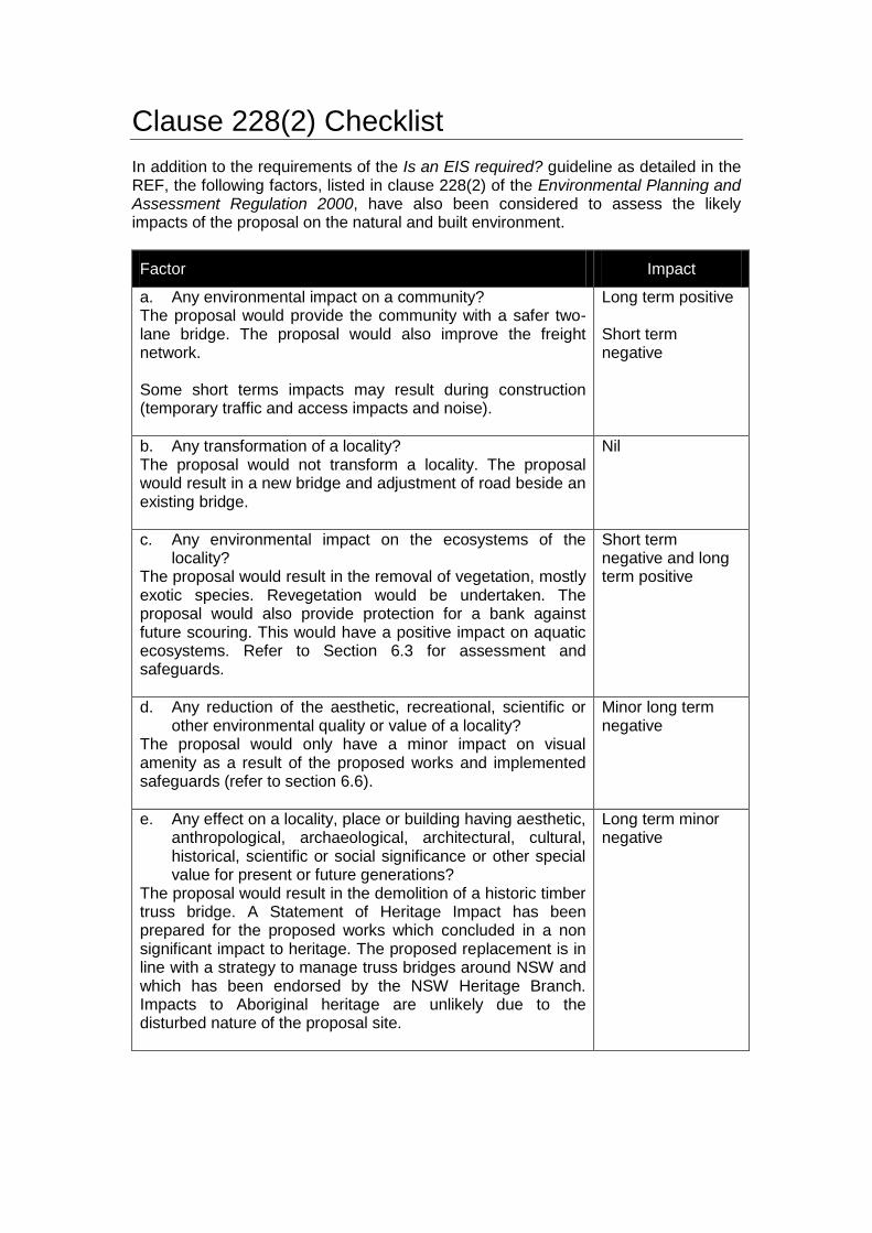
Clause 228(2) Checklist
In addition to the requirements of the Is an EIS required? guideline as detailed in the REF, the following factors, listed in clause 228(2) of the Environmental Planning and Assessment Regulation 2000, have also been considered to assess the likely impacts of the proposal on the natural and built environment.
Factor Impact
a. Any environmental impact on a community? The proposal would provide the community with a safer two-lane bridge. The proposal would also improve the freight network. Some short terms impacts may result during construction (temporary traffic and access impacts and noise).
Long term positive Short term negative
b. Any transformation of a locality? The proposal would not transform a locality. The proposal would result in a new bridge and adjustment of road beside an existing bridge.
Nil
c. Any environmental impact on the ecosystems of the locality?
The proposal would result in the removal of vegetation, mostly exotic species. Revegetation would be undertaken. The proposal would also provide protection for a bank against future scouring. This would have a positive impact on aquatic ecosystems. Refer to Section 6.3 for assessment and safeguards.
Short term negative and long term positive
d. Any reduction of the aesthetic, recreational, scientific or other environmental quality or value of a locality?
The proposal would only have a minor impact on visual amenity as a result of the proposed works and implemented safeguards (refer to section 6.6).
Minor long term negative
e. Any effect on a locality, place or building having aesthetic, anthropological, archaeological, architectural, cultural, historical, scientific or social significance or other special value for present or future generations?
The proposal would result in the demolition of a historic timber truss bridge. A Statement of Heritage Impact has been prepared for the proposed works which concluded in a non significant impact to heritage. The proposed replacement is in line with a strategy to manage truss bridges around NSW and which has been endorsed by the NSW Heritage Branch. Impacts to Aboriginal heritage are unlikely due to the disturbed nature of the proposal site.
Long term minor negative
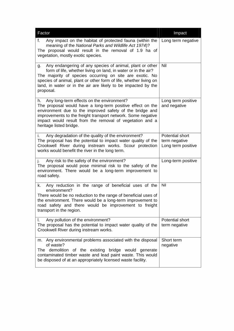
Factor Impact
f. Any impact on the habitat of protected fauna (within the meaning of the National Parks and Wildlife Act 1974)?
The proposal would result in the removal of 1.9 ha of vegetation, mostly exotic species.
Long term negative
g. Any endangering of any species of animal, plant or other form of life, whether living on land, in water or in the air?
The majority of species occurring on site are exotic. No species of animal, plant or other form of life, whether living on land, in water or in the air are likely to be impacted by the proposal.
Nil
h. Any long-term effects on the environment? The proposal would have a long-term positive effect on the environment due to the improved safety of the bridge and improvements to the freight transport network. Some negative impact would result from the removal of vegetation and a heritage listed bridge.
Long term positive and negative
i. Any degradation of the quality of the environment? The proposal has the potential to impact water quality of the Crookwell River during instream works. Scour protection works would benefit the river in the long term.
Potential short term negative Long term positive
j. Any risk to the safety of the environment?
The proposal would pose minimal risk to the safety of the environment. There would be a long-term improvement to road safety.
Long-term positive
k. Any reduction in the range of beneficial uses of the environment?
There would be no reduction to the range of beneficial uses of the environment. There would be a long-term improvement to road safety and there would be improvement to freight transport in the region.
Nil
l. Any pollution of the environment? The proposal has the potential to impact water quality of the Crookwell River during instream works.
Potential short term negative
m. Any environmental problems associated with the disposal of waste?
The demolition of the existing bridge would generate contaminated timber waste and lead paint waste. This would be disposed of at an appropriately licensed waste facility.
Short term negative
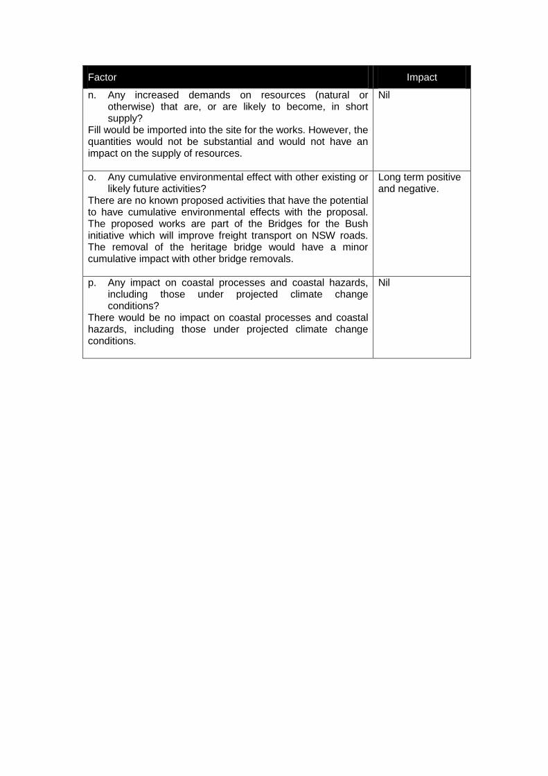
Factor Impact
n. Any increased demands on resources (natural or otherwise) that are, or are likely to become, in short supply?
Fill would be imported into the site for the works. However, the quantities would not be substantial and would not have an impact on the supply of resources.
Nil
o. Any cumulative environmental effect with other existing or likely future activities?
There are no known proposed activities that have the potential to have cumulative environmental effects with the proposal. The proposed works are part of the Bridges for the Bush initiative which will improve freight transport on NSW roads. The removal of the heritage bridge would have a minor cumulative impact with other bridge removals.
Long term positive and negative.
p. Any impact on coastal processes and coastal hazards, including those under projected climate change conditions?
There would be no impact on coastal processes and coastal hazards, including those under projected climate change conditions.
Nil
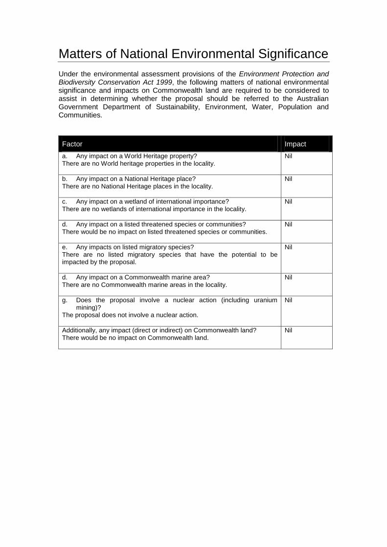
Matters of National Environmental Significance
Under the environmental assessment provisions of the Environment Protection and Biodiversity Conservation Act 1999, the following matters of national environmental significance and impacts on Commonwealth land are required to be considered to assist in determining whether the proposal should be referred to the Australian Government Department of Sustainability, Environment, Water, Population and Communities.
Factor Impact
a. Any impact on a World Heritage property? There are no World heritage properties in the locality.
Nil
b. Any impact on a National Heritage place? There are no National Heritage places in the locality.
Nil
c. Any impact on a wetland of international importance? There are no wetlands of international importance in the locality.
Nil
d. Any impact on a listed threatened species or communities? There would be no impact on listed threatened species or communities.
Nil
e. Any impacts on listed migratory species? There are no listed migratory species that have the potential to be impacted by the proposal.
Nil
d. Any impact on a Commonwealth marine area? There are no Commonwealth marine areas in the locality.
Nil
g. Does the proposal involve a nuclear action (including uranium mining)?
The proposal does not involve a nuclear action.
Nil
Additionally, any impact (direct or indirect) on Commonwealth land? There would be no impact on Commonwealth land.
Nil

Appendix B
Concept design and property acquisition

Appendix C
Communications Plan, Community Update and Community Issues Report
Appendix D
Biodiversity Assessment Report
Appendix E
Visual Impact Assessment Report
Appendix F
Noise and Vibration Impact Assessment Report
Appendix G
Statement of Heritage Impact

Appendix H
Aboriginal Heritage Impact Assessment Report

Appendix I
Hazardous Paint Survey
Appendix J
Soil and Water Testing Results