Embed Size (px)
Citation preview
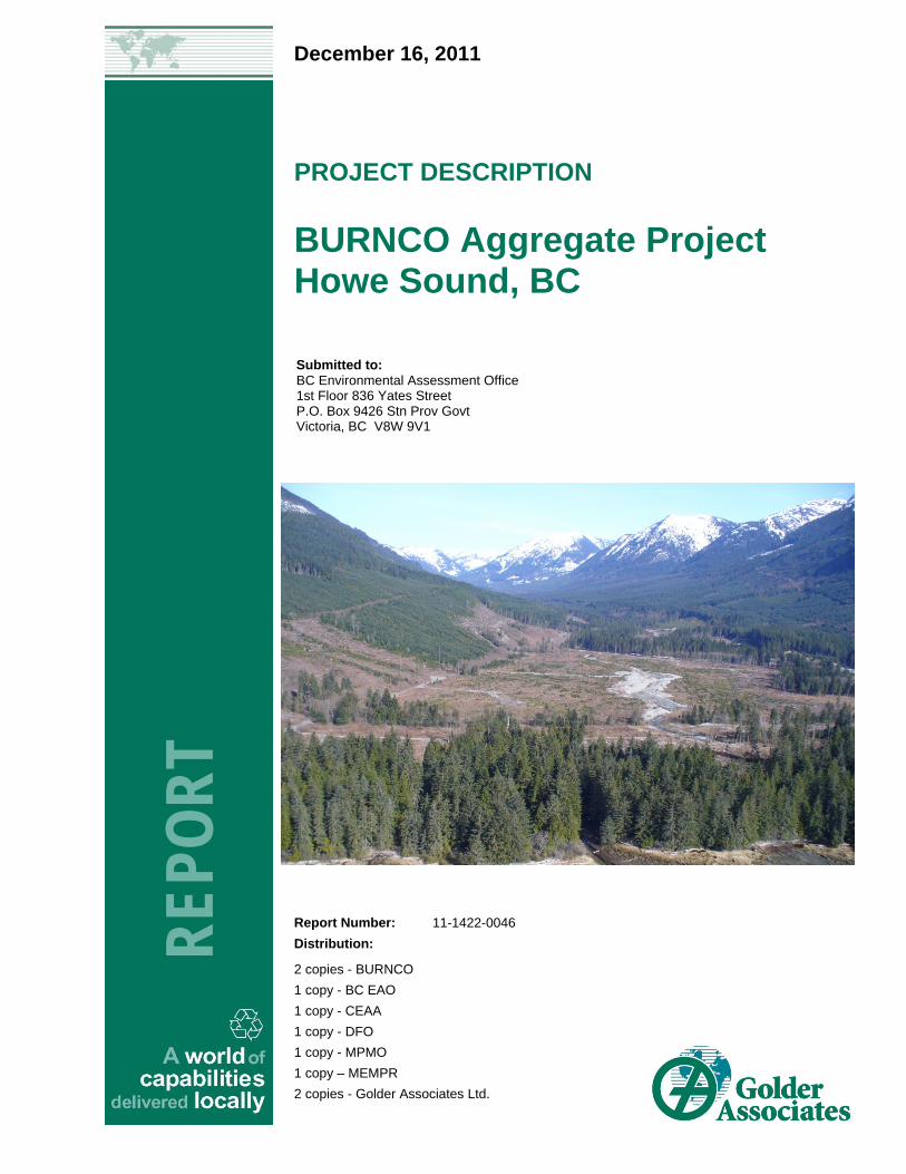
December 16, 2011
PROJECT DESCRIPTION
BURNCO Aggregate Project Howe Sound, BC
REP
OR
T
Report Number: 11-1422-0046
Distribution:
2 copies - BURNCO
1 copy - BC EAO
1 copy - CEAA
1 copy - DFO
1 copy - MPMO
1 copy – MEMPR
2 copies - Golder Associates Ltd.
Submitted to:BC Environmental Assessment Office 1st Floor 836 Yates Street P.O. Box 9426 Stn Prov Govt Victoria, BC V8W 9V1

BURNCO AGGREGATE PROPERTY
December 16, 2011 Report No. 11-1422-0046 i
Executive Summary
The BURNCO Aggregate Project (49 28’ N 123 23’ W) (“Project”) is situated in McNab Valley on the northwest shore of Howe Sound, British Columbia (BC), approximately 22 kilometres (km) west-southwest of Squamish and 35 km northwest of Vancouver. The valley’s glaciofluvial fan-delta comprises a substantial deposit of sand and gravel, and investigations indicate that it constitutes a significant commercially extractable aggregate resource.
The purpose of the BURNCO Aggregate Project Description is to provide a summary description of size and characteristics of the project; location and summary of areas, physical and biological environments; and resources potentially affected by the Project, along with contact information for the Project proponent.
Since 2008, the property has been owned by 0819042 BC Ltd., with common ownership to BURNCO Rock Products Ltd. (“BURNCO”). It is BURNCO’s intent to develop a sand and gravel aggregate pit on the property to initially supply material to their ready-mix concrete plants in south Burnaby and Port Kells, BC. The project will rely on transport of products off-site by barge, and will include development of a marine barge loading facility.
BURNCO’s concrete plants in the Lower Mainland are currently supplied with aggregate from the Orca Sand and Gravel mine at Port McNeil on northern Vancouver Island. The development of the BURNCO Aggregate pit would result in a greater than 280 km reduction in barge tow distance between the current aggregate source and the concrete plants, thereby improving both the environmental impacts and economic viability of BURNCO’s operations.
Although the geological characterization of the property and resources within the Project area is underway, the overall concept for the project is to initially surface-mine material from the sand and gravel deposit within the property; thereafter, excavation of the deposit would be achieved via high-speed clamshell dredge in a defined wetted pit. It is anticipated that excavation of the deposit will proceed to a depth of greater than 15 metres (m) initially and will proceed east from an existing road across the deposit to avoid all existing natural watercourses. Current estimates suggest that initial extraction of the aggregate resource will be on the order of 400,000 tonnes per year, increasing to 1 to 1.6 million tonnes per annum (MTPA) within a few years for the duration of the resource, with possible production ‘spikes’ to a maximum annual anticipated maximum of 4 MTPA, due to potential special project demands, such as large infrastructure works.
Currently, the property is readily accessible only by boat, float plane or helicopter. A road passes along the west side of the valley, with other roads and paths branching off to access other areas. BURNCO has no plans to improve the direct road access into the property. Small boats and float planes can land at an existing dock on the western end of the beach area.
The BURNCO property has been subject to heavy industrial use since the 1940s and forestry activities over the last century. The property has existing facilities in need of maintenance or repair including a marine dock, barge ramp, marine log storage dump, decommissioned fuel storage tanks, maintenance shed – warehouse and biocells in soil protected sites. The BURNCO property has been logged several times since the 1900s, while re-establishment of forest cover on the property in the area of the aggregate deposit has to-date been poor. The site vegetation comprises mainly immature planted conifers and opportunistic deciduous trees. The marine shoreline of the site comprises a sand, gravel and cobble beach, with a log dump, dock and warehouse on a cleared area of the shoreline at the site’s southwest corner.

BURNCO AGGREGATE PROPERTY
December 16, 2011 Report No. 11-1422-0046 ii
Minimal data are available regarding wildlife species present on the site, although Roosevelt elk (Cervus
elaphus), black bear (Ursus americanus), blacktail deer (Odocoileus hemionus), coyote (Canis latrans) and
various bird species have been observed in the valley.
An artificial groundwater-fed channel was constructed on the property by previous owners in the 1980s, and this
channel was extended upstream in 2003. The entire groundwater channel is approximately 1,225 m long by 4 to
12 m wide, but only a small portion in the upper channel is now available as spawning habitat by chum
(Oncorhynchus keta) and coho salmon (O. kisutch). Adjacent to the project site, the McNab Creek mainstem
supports populations of chum, coho, pink (O. gorbuscha) and chinook salmon (O. tshawytscha), cutthroat trout
(O. clarki), rainbow trout and steelhead (O. mykiss).
BURNCO recognizes that an assessment of the project’s environmental effects will be required in order to
understand and address the concerns of government regulators, the public, local government agencies and First
Nations, so as to obtain the necessary permits for the project to proceed. In particular, a BC Mines Act permit
must be obtained to approve the Mine Plan and Reclamation Program, and based on previous discussions with
federal and provincial regulators, it is anticipated that the project will trigger environmental assessments under
the British Columbia Environmental Assessment Act (BCEAA) and the Canadian Environmental Assessment Act
(CEAA).

BURNCO AGGREGATE PROPERTY
December 16, 2011 Report No. 11-1422-0046 iii
List of Abbreviations
AB Alberta
AOA Archaeological Overview Assessment
BC British Columbia
BCEAA British Columbia Environmental Assessment Act
BCEAO British Columbia Environmental Assessment Office
BCTS British Columbia Timber Supply
CDN Canadian
CEAA Canadian Environmental Assessment Act
CMT Culturally Modified Tree
CWS Canadian Wildlife Service
DFO Department of Fisheries and Oceans Canada
EAC Environmental Assessment Certificate
EMP Environmental Management Plan
EMPR Energy Mines Petroleum Resources
GSB Geological Survey Branch
GHG Greenhouse gas
HADD Harmful Alteration, Disruption or Destruction of Fish Habitat
HCA Heritage Conservation Act
lb Pound
MEMPR Ministry of Energy Mines
MPMO Major Projects Management Office
MTPA Million tonnes per annum (year)
NOW Notice of Work
NRC Natural Resources Canada
NWPA Navigable Waters Protection Act
ppm Parts per Million
ROW Right-of Way
SARA Species at Risk Act
TPY Tonnes per Year

BURNCO AGGREGATE PROPERTY
December 16, 2011 Report No. 11-1422-0046 iv
Table of Contents
1.0 INTRODUCTION ............................................................................................................................................................... 1
1.1 LOCATION .......................................................................................................................................................... 1
2.0 PROPONENT INFORMATION ......................................................................................................................................... 2
2.1 Proponent Identification ....................................................................................................................................... 2
2.2 Key Proponent Contacts ...................................................................................................................................... 2
3.0 PROJECT JUSTIFICATION ............................................................................................................................................. 4
3.1 Need for the Project ............................................................................................................................................. 4
3.2 Estimated Resource ............................................................................................................................................ 5
4.0 PROJECT OVERVIEW ..................................................................................................................................................... 6
4.1 Project Components ............................................................................................................................................ 6
4.1.1 Pit Development ............................................................................................................................................. 6
4.1.2 Processing ..................................................................................................................................................... 7
4.1.3 Marine Loading Facility and Barging .............................................................................................................. 7
4.1.4 Other Facilities, Infrastructure and Alternatives ............................................................................................. 8
4.2 Project Emissions, Discharges and Waste .......................................................................................................... 9
4.3 Reclamation, Closure and Monitoring ................................................................................................................ 10
4.4 Labour ............................................................................................................................................................... 10
4.5 Cost ................................................................................................................................................................... 11
5.0 PROJECT SETTING (AGGREGATE SITE AND BARGE ROUTE) ............................................................................... 12
5.1 Physical Setting ................................................................................................................................................. 12
5.1.1 Geology ........................................................................................................................................................ 12
5.1.2 Climate and Physiography ........................................................................................................................... 12
5.1.3 Hydrogeology ............................................................................................................................................... 13
5.1.4 Hydrology ..................................................................................................................................................... 13
5.2 Biological Setting ............................................................................................................................................... 13
5.2.1 Freshwater Environment .............................................................................................................................. 13
5.2.1.1 Natural Waters .......................................................................................................................................... 13
5.2.1.2 Constructed Groundwater Channel .......................................................................................................... 15
BURNCO AGGREGATE PROPERTY
December 16, 2011 Report No. 11-1422-0046 v
5.2.1.3 Wildlife ...................................................................................................................................................... 15
5.2.2 Marine Environment ..................................................................................................................................... 15
5.2.3 Terrestrial Environment ................................................................................................................................ 16
5.2.3.1 Ecological Setting ..................................................................................................................................... 16
5.2.3.2 Wildlife ...................................................................................................................................................... 17
5.2.3.2.1 Mammals ............................................................................................................................................... 17
5.2.3.2.2 Birds ...................................................................................................................................................... 17
5.2.3.2.3 Reptiles and Amphibians ....................................................................................................................... 17
5.2.3.3 Species at Risk ......................................................................................................................................... 18
5.2.3.3.1 Southern Resident Killer Whales ........................................................................................................... 21
5.3 Human Setting ................................................................................................................................................... 21
5.3.1 Socio-community ......................................................................................................................................... 21
5.3.1.1 First Nation Setting ................................................................................................................................... 21
5.3.2 Regional and Local Community ................................................................................................................... 22
5.3.3 Industrial Setting .......................................................................................................................................... 22
5.3.4 Land, Water and Resource Use ................................................................................................................... 23
6.0 POTENTIAL ENVIRONMENTAL EFFECTS OF THE PROJECT .................................................................................. 24
7.0 SUSTAINABILITY FACTORS ........................................................................................................................................ 28
8.0 FIRST NATIONS AND PUBLIC CONSULTATION ........................................................................................................ 30
8.1 First Nations Consultation and Engagement ..................................................................................................... 30
8.1.1 Project Mine Footprint .................................................................................................................................. 30
8.1.2 Mine Product Shipping Barge Route ............................................................................................................ 31
8.2 Public, Stakeholder and Agency Consultation ................................................................................................... 32
8.3 Consultation Planning and Activities .................................................................................................................. 33
8.4 Long-term Property and Resource Stewardship ................................................................................................ 33
9.0 ENVIRONMENTAL ASSESSMENT REVIEW PROCESSES ......................................................................................... 34
9.1 Provincial ........................................................................................................................................................... 34
9.2 Federal .............................................................................................................................................................. 34
9.2.1 Common Federal Triggers and Issues ......................................................................................................... 35
9.2.1.1 Canadian Environmental Protection Act ................................................................................................... 35

BURNCO AGGREGATE PROPERTY
December 16, 2011 Report No. 11-1422-0046 vi
9.2.1.2 Fisheries Act ............................................................................................................................................. 35
9.2.1.3 Explosives Act .......................................................................................................................................... 36
9.2.1.4 Navigable Waters Protection Act .............................................................................................................. 36
10.0 OTHER REQUIRED PERMITS AND APPROVALS ....................................................................................................... 37
11.0 SCHEDULE .................................................................................................................................................................... 39
12.0 CONCLUDING REMARKS ............................................................................................................................................. 40
TABLES
Table 1: Species at Risk that Potentially Occur on the BURNCO Aggregate Property
Table 2: Preliminary Assessment of Potential Project Related Effects and Possible Mitigation
Table 3: Public, Stakeholder and Agency Consultation
Table 4: BURNCO Aggregate Project Technical Studies Completed October 2010 and Submitted to DFO as Part of the
Supplementary Review
Table 5: Permits and Approvals Potentially Required for the Project
Table 6: Project Schedule
FIGURES
Figure 1: Key Map, Parks, Environmental Sensitive Area, Resource Use Areas
Figure 2: Proposed Conceptual Site Layout
Figure 3: Proposed and Existing Barge Shipping Routes
Figure 4: Area Watercourse Classification
Figure 5: Resource and fisheries areas
APPENDICES
APPENDIX A Photographs
BURNCO AGGREGATE PROPERTY
December 16, 2011 Report No. 11-1422-0046 1
1.0 INTRODUCTION The BURNCO Aggregate Project (“the Project”) has proposed the development of a sand and gravel pit to
provide high quality construction aggregates for use in British Columbia’s (BC) Lower Mainland. The anticipated
production volumes of the project range from 1 to 1.6 million tonnes per annum (MTPA), with all products leaving
the site in coastal barges that will be loaded at a dedicated facility constructed at the location of a former log
dump and within an existing marine foreshore lease.
The purpose of the BURNCO Aggregate Project Description is to provide a: summary description of size and
characteristics of the project; location and summary of areas, physical and biological environments; and
resources potentially affected by the Project, and contact information for the Project proponent.
1.1 LOCATION The Project will be located on a flat, glaciofluvial fan-delta deposit comprising sand and gravel on the western
shore of Howe Sound’s Thornbrough Channel, north of Gambier Island and approximately 22 km west-
southwest of Squamish and 35 km northwest of Vancouver (Figure 1). The project site’s geographic coordinates
are 49 34’ 00”N 123 23’ 20”W.
The Project will be located on a 320 hectare (ha) private property (“the Property”) that has been owned since
2008 by 0819042 BC Ltd and BURNCO Rock Products Ltd. The individual properties that together comprise the
site are:
DL 677 LD 37 New Westminster Group 1;
DL 677A LD 37 New Westminster Group 1;
DL 6778 LD 37 New Westminster Group 1;
PCL A DL 677B LD 37 New Westminster Group 1; and,
Foreshore Tenure #240515.
The Property was formerly four-wheel-drive accessible along a network of logging roads. However, many of
these roads were decommissioned in 2008 and 2009 under existing obligations by Canfor Ltd. (a previous site
owner), and consequently vehicular access is via all-terrain-vehicle only. Outside the BURNCO property, a road
passes along the western side of the valley, with other roads and paths branching off to access other areas
(Figure 2, Appendix A). BURNCO has no plans to improve the direct road access to the site. Currently, the site
is readily accessible only by boat, float plane or helicopter. Small boats and float planes can land at the west
portion of the site beach area at an existing dock and shoreline loading area (Appendix A, Photograph 3).
McNab Creek (BC Watershed Code 900-106300) flows along the east side of the Property outside the proposed
project area. The creek is a 12.7 km long, fourth-order watercourse that drains directly into the marine
environment of Howe Sound (Figures 1, 2, Appendix A).

BURNCO AGGREGATE PROPERTY
December 16, 2011 Report No. 11-1422-0046 2
2.0 PROPONENT INFORMATION
2.1 Proponent Identification BURNCO Rock Products Ltd. (“BURNCO”) is a private business that was founded in 1912. BURNCO is based
in Calgary, with operations in Saskatchewan, throughout Alberta and now BC, and is Canada’s largest
independent ready-mix concrete company. Operations were established in BC within the Metro Vancouver,
Shuswap and Okanagan regions in 2004. BURNCO employs over 800 people and has developed four main
divisions within its operations as follows:
Aggregate operations to supply sand, gravel and crushed stone used in construction; a permitted aggregate
project in West Kelowna has recently been developed to supply the central Okanagan;
Landscape centres to distribute landscape materials to contractors and homeowners in Alberta and BC;
Ready-mix operations to provide concrete to construction projects throughout BC and Alberta; and,
Asphalt operations to produce a range of hot and cold mixes for paving projects in Alberta.
2.2 Key Proponent Contacts Proponent: BURNCO Rock Products Ltd.
www.BURNCO.com
Mr. Derek Holmes, Regional Manager
B.C. Aggregate Division
BURNCO Rock Products Ltd
1A, 2760 Emerson Street.
Abbotsford, BC V2T 3J6
Phone: 604-345-4382
Fax: 604-859-3319
E-mail: [email protected]
Mr. J. Kim Titus, Vice President
Aggregate Division
BURNCO Rock Products Ltd
200, 155 Glendeer Circle S.E.
Box 1480, Station T
Calgary, AB T2H 2P9
Phone: 403-255-2600
Fax: 403-255-0323
E-mail: [email protected]

BURNCO AGGREGATE PROPERTY
December 16, 2011 Report No. 11-1422-0046 3
BURNCO’s Environmental Assessment Representative: Golder Associates Ltd.
Mark Johannes
Associate, Senior Environmental Specialist
Golder Associates Ltd.
500-4260 Still Creek Drive
Burnaby, BC V5C 6C6
Phone: 604-296-4261
Fax: 604-298-5253
E-mail: [email protected]

BURNCO AGGREGATE PROPERTY
December 16, 2011 Report No. 11-1422-0046 4
3.0 PROJECT JUSTIFICATION
3.1 Need for the Project Investigations indicate that a commercial aggregate resource is present on the Property. Construction
aggregates are produced from sand, gravel and crushed rock, which are naturally-occurring, environmentally
benign materials. The production of aggregate relies solely on physical processes (e.g., sizing, crushing and
washing), and no chemical processing is involved.
Aggregates are used in a wide range of construction and development applications:
Transportation infrastructure, ports, road construction, airports – preload, road base, asphalt pavement,
curb/gutter, concrete;
Housing – fill, concrete foundations, walls, slabs, concrete block, brick, stucco, roofing, drainage;
Municipal works – sewers, roads, parks, sidewalks, paths;
Schools, hospitals, arenas, theatres, civic works – fills, concrete, parking lots;
Commercial – malls/shopping centres, roadways, parking; and,
Industrial – buildings, parking, roads.
Each of these applications consumes significant volumes of specialized aggregate products produced by sand
and gravel pits and/or quarries. Cumulatively, 10 to 15 tonnes of aggregate per year are consumed for every
BC resident.
With the steady growth of the population of BC’s South Coast, along with continued depletion of existing local
aggregate supplies, there is a need to locate and develop new sources of aggregate in proximity to the Lower
Mainland. The relative cost of aggregate is often low, but transportation costs are high, often eclipsing the cost
of the product. Shipping by water is the most cost-effective way of transporting aggregate products, and
shipping short distances by water further reduces environmental and societal costs.
BURNCO’s concrete plants in the Lower Mainland are currently supplied with aggregate purchased mainly from
the Orca Sand and Gravel Quarry at Port McNeil on northern Vancouver Island. BURNCO proposes to develop
its own aggregate source much closer to its existing ready-mix concrete plants in the Lower Mainland, to reduce
transport costs, provide more sustainable environmental options and facilitate future viable business growth.
BURNCO’s three other divisions (asphalt, aggregate and landscape) also require access to an aggregate
resource to meet projected demands in the BC marketplace. The development of the Project will result in a
significant 280 km one-way reduction in barge tow distance between the current primary aggregate supply
(i.e., Port McNeil) to BURNCO’s Lower Mainland operations.

BURNCO AGGREGATE PROPERTY
December 16, 2011 Report No. 11-1422-0046 5
3.2 Estimated Resource Based on preliminary volume estimates, the aggregate resource is projected to conservatively exceed
30 million tonnes of sand and gravel, giving the Project an expected economic lifespan of 20 years.
Investigations to confirm the size of the resource, some of which are ongoing at this time, are required to more
accurately determine the size and characteristics of the deposit. The extraction model used for the site will
dictate the actual tonnage of aggregate production. Variables used to estimate the actual extracted volumes
include:
Geometry of pit;
Side slope angles;
Stratigraphy of deposit (textures, quality, thickness of various formations);
Setbacks used in pit development;
Depth of extraction; and,
Pit surface area.
The actual commercially extractable aggregate resource volume will be revised depending upon the information
and design of the mine plan and the aggregate resource evaluation.

BURNCO AGGREGATE PROPERTY
December 16, 2011 Report No. 11-1422-0046 6
4.0 PROJECT OVERVIEW 4.1 Project Components The sand and gravel pit development is proposed to take place within a 70 ha clear-cut (2002 to 2004) area of
the Property (Figure 2). The processing plant will be located in the cleared areas near the existing warehouse
and land-based log sorting area south of BC Hydro’s right-of way (ROW). All components of the project will be
outside existing natural watercourses and riparian areas (Figure 2). Sorted aggregate products will be conveyed
from the plant to sand and gravel barges via a barge-loading facility adjacent to the marine foreshore to the
south of the pit, located within an existing foreshore lease and log dump area at the southwest corner of the
Property (Figure 2). The specific location and configuration of the processing plant and conveyor/loading facility
will be determined based on detailed site planning to avoid and limit impacts on the foreshore, along with
forested areas. Barged aggregate products will be delivered to existing BURNCO facilities in either Burnaby or
Langley (Figure 3).
BURNCO will manage the remainder of the Property as private forest lands and will accommodate other
industrial or transportation use, or needs of neighbouring property owners. At the end of the Project’s life span,
BURNCO will maintain ownership and manage long term stewardship for forest, fisheries, wildlife and water
resources on the property.
4.1.1 Pit Development
Sand and gravel will be extracted from the pit using an electrically powered floating clamshell dredge equipped
with a primary crusher and a floating conveyor system. This equipment will be initially placed on the western
area of the deposit and will dig downward to form a pit (which will fill with water from natural groundwater input).
The dredge will float on the surface of the pit pond formed. From this location, the floating clamshell will work to
extract material based on the aggregate deposit and mine plan, gradually enlarging the pond (Figure 2).
Because portions of the gravel deposit extend to approximately >15m below the surface in some locations and
because most of the resource is below the water table, a floating clamshell dredge will be used to extract sand
and gravel. No pit dewatering will be required, and no explosives will be used.
A portion of the constructed artificial groundwater channel currently in the centre of the Property serves as a
“French drain” that lowers the overall level of the water table within the lower Property area. As the pit pond is
developed through the Project life-cycle, the level of the pond overflow will be maintained so to raise the water
table across the property to re-establish a more natural groundwater level.
The existing logging road network running parallel to the creek at the north end of the proposed pit will be used
as a hydraulic training berm, which will limit potential flood events and limit potential surface water avulsion into
the project site and pit. Hydraulic and avulsion studies (2010) indicate the road can and has been used as a
berm in the area adjacent to the right-handed south turning bend on McNab Creek (Figure 2). Fisheries and
Oceans Canada (DFO) work in the area in 2001 and 2002 developed the road into the berm by addition of
material to gain elevation. Detailed hydrologic and hydraulic characterization of the site is underway and results
will be used to guide the pit and mine plan. Preliminary studies in 2010 and a DFO independent review in 2010
indicate a viable aggregate mine plan is possible for the site.

BURNCO AGGREGATE PROPERTY
December 16, 2011 Report No. 11-1422-0046 7
As proposed sand and gravel extraction proceeds through the Project’s life span (Figure 2), the overburden will
be removed and stockpiled around the project area. This material can be used for future site reclamation when
combined with the inorganic fines extracted from the sand and gravel during processing (Figure 2). No material
from the pit will be disposed-of at sea. The final site reclamation will include a ground- and surface water-fed
pond, with the surrounding areas to be reclaimed by contouring the landscape, revegetation and planted forest.
4.1.2 Processing
The processing plant will be located in a preloaded area above the pit elevation to enhance water recycling
process and drainage. The plant will be situated in the southwestern corner of the Property outside of buffer
areas around watercourses and the marine foreshore. The existing 300 m wide treed buffer will be largely
maintained between the proposed project site and the marine shoreline to avoid and limit potential visual, noise,
dust and emission impacts on the environment. Nonetheless, dust and noise suppression and mitigation
measures will be fully applied and maintained throughout project construction, operation and closure stages of
the project. Dust and noise suppression and mitigation measures have been successfully implemented by
BURNCO in multiple urban operations to avoid and limit impacts.
Processing of the dredged material will involve screening the fines from the gravel and further screening to
separate the different aggregate sizes. Oversize gravels will be crushed. The sand will be sized and dewatered
to remove silt-sized fractions, and the wash water will be sent to sedimentation ponds for removal of silt and
reuse of water by means of a 95% efficient recycling process. Water will be recycled from settling ponds, which
will have an initial estimated capacity of some 15,100 litres per hour (L/hour) (4,000 gallons per hour). The
process site will be secured and processing water will not be discharged.
The processed sand and gravel products will be conveyed to a stockpile area prior to loading onto barges.
Initially the processing plant may be active 12 hours per day, 260 days per year.
There will be at least seven stockpiles of different aggregate product types. A conveyor will feed material from
below the storage piles to the barge conveyor using an automated materials-handling system. This handing
system in turn limits fuel-powered equipment and non-renewable energy use and emissions, avoids and limits
dust and noise, and increases plant efficiency. All processing facilities will be fully enclosed above ground.
The nature of extraction and processing at the Project, coupled with the availability of electricity from the nearby
BC Hydro transmission line, will allow the use of electric motor-driven systems for processing to limit greenhouse
gas emissions from the project.
4.1.3 Marine Loading Facility and Barging
The marine loading facility will be designed to accommodate up to 5,000 to 6,000 deadweight tonnage (DWT)
barges (80 m LOA, draught 4.5 m). The location of the barge loading facility has been proposed within the
existing foreshore lease and log dump area (Figure 2).

BURNCO AGGREGATE PROPERTY
December 16, 2011 Report No. 11-1422-0046 8
The loading facility will consist of a limited series of pilings that support a fixed, above-ground electric conveyor
with a capacity of 1,000 tonnes per hour. Construction of the facility will involve installation of steel pilings in the
foreshore and subtidal area where needed, and construction of sleeper foundations on the ground surface away
from the foreshore. The land conveyor, between the process plant and the barge loader, will be supported on
ties and sleeper foundations on the ground surface.
The bathymetry of the nearshore marine environment in the area of the proposed marine loading will not require
dredging. Marine dredging or marine disposal of dredgeate, liquid or solid waste will not be a part of this project.
No explosive use is planned.
During operation, tug boats will deliver empty barges and pick up aggregate filled barges. The barge loading
facility is expected to be operational less than 300 days per year. A mooring buoy will be located in deeper
water for barge storage within the lease and the log dump area.
Filled barges will be towed through existing barging routes and navigational channels from the site through the
Ramillies Channel, Howe Sound to the Fraser River through established shipping traffic lanes (Figure 3). Filled
barges will use North Arm of the Fraser River to deliver barges to existing BURNCO facilities in Burnaby
(59 km), and will use the South Arm of the Fraser River to deliver BURNCO facilities in Langley (102 km).
BURNCO presently uses Seaspan tugs and barges to deliver aggregate to existing BURNCO facilities from Port
McNeil (360 km). Seaspan and other tug barge, and log booming operators use the Ramillies Channel in Howe
Sound, along with the existing shipping routes in the Fraser River to move bulk materials.
4.1.4 Other Facilities, Infrastructure and Alternatives
Additional facilities associated with the proposed project will include:
Site office and communications building, with offices and boardroom;
Workers lunch/dry room;
Washroom facilities;
First aid facility with attendant and helipad;
Caretaker’s cabin;
Upgrades to a small craft dock (48 linear metres) with tie-up area for a float plane, serviced with 30 amp (A)
125 volt (V) shore power;
Upgrades to a boat launch adjacent to the dock for various small craft;
Upgrades to an existing marine barge grid and abutment for heavy equipment loading/offloading on site. In
addition, supplies on trucks for the project will be brought over by barge and delivered to the site by way of
the marine barge grid;
Upgrades to the existing fuelling facility for the storage of diesel and gasoline for on-site equipment;
Upgrades to the existing heavy equipment maintenance shop and warehouse;

BURNCO AGGREGATE PROPERTY
December 16, 2011 Report No. 11-1422-0046 9
Electrical substation located adjacent to existing BC Hydro transmission line;
Outdoor switchyard, electric building, and 100 m electric transmission line ;
Pump room for well/stream intake water distribution and fire-fighting, based on existing water licence;
Sewage and stormwater treatment facility;
Site lighting where required;
Trench drains, catch-basins and manholes directed to a retention pond or water treatment and recycling
plant; and,
Short term portable concrete batch plant for project facilities during the construction phases.
Alternatives to the main project components including: pit development and extraction, processing plant and
marine loading facilities will be sited and oriented in the project area based on the final mine plan and resource
evaluation. Figure 2 illustrates the projected aggregate mine components and general siting within the project
area. Detailed designs, plans and specific locations for siting and life cycle development of the aggregate pit,
siting of the processing plant and marine loading facility will be finalized through mine resource evaluation and
mine plan designs. The general characteristics of the project components are consistent with existing aggregate
mine development. The project components will be designed to use methods and updated technology for
aggregate extraction, processing and marine loading and transportation to limit potential effects on the
environment. The project components are proposed to be constructed over a six month period using weekly
barges as supply for construction materials.
4.2 Project Emissions, Discharges and Waste Sand and gravel projects can potentially produce a variety of emissions, discharges and wastes, such as:
Emissions of atmospheric contaminants, such as dust and exhaust gases produced by fossil fuel-burning
equipment (e.g., during extraction and sorting of the sand and gravel resource, barge loading and shipping
of the products to market);
Liquid discharges (e.g., process water and sewage) into the freshwater and marine environment; and,
Solid wastes, such as household and industrial wastes (e.g., lubricant containers, worn-out equipment
parts) associated with facility operation.
BURNCO AGGREGATE PROPERTY
December 16, 2011 Report No. 11-1422-0046 10
The Project will be constructed and operated to avoid, limit and mitigate emissions, discharges and wastes as
follows:
Atmospheric contamination (dust) will be minimized during project operation through extraction of the
aggregate resource under wet conditions using a clamshell dredge, which will limit dust emissions.
Processing facilities will be fully enclosed and operated under wet conditions to limit dust;
The use of electrically powered equipment to extract, process and load the aggregate resource will
minimize the amount of exhaust emissions related to burning fossil fuel during aggregate extraction;
The proximity of the project site to BURNCO’s markets in the Lower Mainland is also intended to reduce
barging distance relative to present aggregate barging and; therefore, minimize exhaust emissions related
to transportation of the aggregate products to market;
Discharge of water used in gravel/sand washing will be minimized by retaining the wash water in
sedimentation ponds for silt removal and reuse of water by means of a 95% efficient recycling process;
and,
Household and industrial solid wastes associated with facility operation will be barged off-site and disposed
of in an approved landfill facility.
4.3 Reclamation, Closure and Monitoring The Project will use progressive reclamation of the site that includes ongoing reclamation activities taking place
alongside ongoing extraction throughout the proposed operations area. A preliminary Reclamation and Closure
Plan will be prepared as part of the Environmental Assessment Certificate (EAC) Application, and will describe
the proposed measures and commitments to remove surface facilities and reclaim areas and develop a
functional ecosystem in the freshwater pit.
Site planning will include landscaping, further design and development of the existing training berm along the
north edge logging road of the pit area, along with the creation of surface water features, fisheries habitats and
revegetation throughout the site consistent with the operational extraction schedule. Ongoing monitoring will be
conducted for relevant noise and dust, water quality parameters, along with fish and wildlife resources.
BURNCO proposes to provide interim monitoring reports summarizing the progress of ongoing reclamation
activities.
4.4 Labour The Project is expected to provide approximately 80 person-years of employment during the construction phase,
and at least 360 person-years of employment during the operation phase. The Project is expected to results in
eight full-time (40 hr work-week) employees, five part time (20 hr work-week) for mine pit operations on-site
(40 hours full time and 20 hours part time) and four full-time direct employees for transportation and distribution
of aggregate resources to BURNCO’s operating facilities.

BURNCO AGGREGATE PROPERTY
December 16, 2011 Report No. 11-1422-0046 11
It is expected that employees traveling to and from the work site, and delivery of essential equipment and
materials such as fuel and parts will be by boat, barge, or water taxi from Gibsons and/or Horseshoe Bay. The
nearby communities (e.g., Squamish, Gibsons, West Vancouver) have available temporary accommodation to
meet all requirements during construction. Therefore, there is not anticipated to provide a construction camp on
the site or any other residential facilities at any time with the exception of a caretaker’s cabin for security and
facility care.
4.5 Cost The estimated capital cost of the project is less than CDN $60 million including the following preliminary cost
breakdown:
Pit Area and Clam Shell - $7.9 million;
Process Plant Area - $15.1 million;
Reclaim Transfer Area - $3.5 million;
Barge Loader Area - $7.4 million;
Electrical and Substation - $7.8 million;
Site (drainage and water treatment, fire protection, site grading, services);
Other costs including environmental assessment, resource valuation, additional engineering studies; and,
Contingency - $12.5 million.

BURNCO AGGREGATE PROPERTY
December 16, 2011 Report No. 11-1422-0046 12
5.0 PROJECT SETTING (AGGREGATE SITE AND BARGE ROUTE)
5.1 Physical Setting 5.1.1 Geology
The Project site is located within the Coast Mountains adjoining Howe Sound and geologically within the
“Coast Plutonic Complex”, which is generally characterized as granitic plutonic bedrock. Within the site,
metasedimentary rock (e.g., phyllite, slate) crops out locally on the west side of the property, although
granodiorite bedrock dominates the area. In addition, some possible volcanic units are reported within the
valley. The surrounding mountain peaks are dominantly formed of granodiorite plutonic rock.
Unconsolidated glaciofluvial and glacial sediments dominate the surficial geology of the Property, although
post-glacial fluvial deposits occur in the valley. The sand-and-gravel fan-delta extends from the valley into Howe
Sound, with a steep drop-off located a distance of a few hundred metres offshore. It is likely that the valley fan
was created as glacial ice receded and decayed some ten thousand years ago, well after the present
Howe Sound fjord was formed. Glacial decay would have produced significant sediment deposition due to
higher water volumes.
The bedrock surface on which the fan has accumulated is likely to be undulating and irregular, with the deposit
thickness ranging between 50 to 100 m (approximately). The stratigraphy of the fan is variable, with textural and
compositional range consistent with the variable prevailing sedimentological and hydraulic conditions at the time
and locale of deposition. In addition, sediment provenance reflects local bedrock geology and is dominated by
granitic rock, with some volcanic and metamorphic components.
Due to the nature of the deposit (i.e., unconsolidated sediments) and the underlying geology, acid rock drainage
is not expected to be an issue on the BURNCO property.
5.1.2 Climate and Physiography
The setting of the Property is on a glacially-derived sand and gravel fan-delta near sea level (10 to 50 m above
sea level (asl)) at the mouth of a glaciated coastal mountain valley (Figures 1 and 2), on the shore of a fjord.
The mountain peaks that surround the valley reach a height of more than 1,500 m asl, although the topography
of the Property is relatively flat.
The Property and Barge route are located in the Coastal Western Hemlock very wet maritime biogeoclimatic
zone, submontane (CWHvm1) variant. The CWHvm1 has a wet climate, with cool summers and mild winters
with relatively little snow (Pojar et al. 1991) and a prolonged moderate temperature growing period.
The summer climate on the Property and Barge route is typically warm and dry; from June until late September
the average temperature is from 20 to 28 degrees centigrade (C). Winters between November until February
are typically mild and wet, with an average temperature range between 0 to 10C. Although snowfall occurs
occasionally, most of the precipitation is in the form of rain.

BURNCO AGGREGATE PROPERTY
December 16, 2011 Report No. 11-1422-0046 13
5.1.3 Hydrogeology
Preliminary data from groundwater characterization indicates that the groundwater contours slope down the
valley into the constructed groundwater channel that was built on the site by DFO and others. Due to the coarse
sediment texture, the sands and gravels of the valley fill are typically highly permeable. The presence of the
groundwater channel appears to depress the groundwater surface within approximately 150 m of the channel.
Groundwater maintains a positive pressure across the site flowing into the ocean during all levels of tide.
5.1.4 Hydrology
The Project site comprises a portion of the McNab valley and watershed. McNab Creek (BC Watershed Code
900-106300) flows north-easterly for approximately 12.7 km from its headwaters on Thirtynine Mountain to its
mouth on the western shore of Thornbrough Channel. The watershed has a surface area of 6,330 ha and, with
the exception of the BURNCO Property and neighbouring strata development, is entirely situated on Crown land.
Where it flows across or adjacent to the Property, McNab creek has a low-gradient channel with gravel and
cobble bars. There are no glaciers and few alpine areas of late-persisting snow within the watershed. Lakes
comprise less than 1% of the watershed area and there is no significant water storage except in snowpacks, and
groundwater.
Typical of coastal watersheds the highest stream flow in McNab Creek occur during the autumn/winter months
(October through January), when rainfall is greatest (~3,200 millimetres (mm) average). From February onward,
average monthly flow declines until late summer (August), when the lowest flows occur. Flows increase abruptly
with the onset of the autumn rains in September and October.
The Project barging route comprises portions of the lower Fraser River in the both the North and South Arms.
The Fraser River has a watershed basin size of approximately 235,000 square kilometres (km2) and an overall
river length of approximately 1,375 km. The lower 100 km of river length is considered the lower Fraser River
and floodplain. The average discharge below Hope within the barging route is approximately 3,500 cubic metres
per second (m3/s). Fraser River discharge is seasonal with summer melt flows more than ten times greater than
the winter discharge. The lower portion of the Fraser River from the river mouth to Mission is influenced by tidal
cycles from the Strait of Georgia.
5.2 Biological Setting 5.2.1 Freshwater Environment
5.2.1.1 Natural Waters
McNab Creek - The lower 1 km of the McNab Creek channel and estuary is heavily aggraded with sand, cobble
and boulders due to recent and historic forest harvesting in the upper portions of the watershed (Appendix A,
Photograph 6) (Figure 4). Lower McNab Creek presently experiences lateral movement across a channel that
has a maximum width of 200 m fan within its channel. The site where the sand and gravel pit is proposed does
not include the creek, and contains no natural surface waters (Figure 2).
BURNCO AGGREGATE PROPERTY
December 16, 2011 Report No. 11-1422-0046 14
Where it flows on or adjacent to the Property, McNab Creek supports salmon runs of chum (Oncorhynchus
keta), pink (O. gorbuscha), coho (O. kisutch) and chinook (O. tshawytscha) salmon, as well as resident and
sea-run cutthroat (O. clarki clarki) and rainbow trout/steelhead (O. mykiss). Other species, such as sculpins
(Cottus spp.) are also present. Records of salmon escapement show an average adult salmon return (DFO –
Salmon Escapement Data System) to McNab Creek range from 200 to 1,500 spawners and average less than
500 salmon. Chum salmon comprise greater than 50% of the adult salmon previously observed in the creek.
Salmon escapement surveys and enumeration have been completed annually since 2009 and indicate salmon
habitat use within the lower 2 km of the creek.
Harlequin Creek - A non-gazetted watercourse known locally as Harlequin Creek (or “SS Creek”) flows
eastward down the hillside to the west of the project, before turning southward to flow toward Howe sound along
the west side of a logging road (Figure 4). The creek flows under the logging road bridge a short distance
upstream from its mouth on Howe Sound. Harlequin Creek is fish-bearing and supports cutthroat trout, sculpins,
and in the lower 200 m below a beaver dam, juvenile coho salmon. Harlequin Creek is situated outside the
proposed Project footprint and is not expected to be affected by the project.
Another small, ephemeral unnamed watercourse is situated in the cutblock immediately north of Harlequin
Creek. This creek flows into the marine foreshore of the site (Figure 4). This watercourse may support cutthroat
trout during the winter months and a limited population of coho salmon. The creek experiences limited flows
during summer months. Like Harlequin Creek, this channel is situated outside the proposed project footprint,
and is not expected to be affected by the project.
Natural Shoreline Channels (Foreshore Inlets) - Three short inlets and channels are located within the marine
foreshore (400, 600, and 820 m west of the mouth of McNab Creek) of the Project site (Figure 4). The channels
are tidally influenced and have a substrate composed mostly of mud. Their flow is partially freshwater when they
are exposed at low tide, but become inundated by saltwater marine tidal waters when the channels are flooded
at high tide. Relatively little freshwater flow is present in the western two channels, but there is comparatively
more flow in the easternmost channel determined by seasonal connection with the artificial constructed
groundwater channel to the east and north in this foreshore inlet and channel. The low tide fish fauna of the
three channels comprises prickly sculpin (Cottus asper), tidepool sculpin (Oligocottus maculosus) and
saddleback gunnel (Pholis ornata), all of which tolerate a wide range of salinities. Coho and other salmonids
species have been infrequently captured in these channels and are considered to have spring and wetted
summer season use as habitats prior to drying during periods of low flow.
Lower Fraser River to Langley – The proposed Project barging route comprises portions of the tidally
influenced lower Fraser River in both the North and South Arms. The lower Fraser River in both the North and
South Arms provides habitat for over 25 species of fish, along with providing a corridor and habitat for migratory
and resident waterfowl. Most of the salmonid, sturgeon, surf smelt and eulachon fish species use the lower
Fraser River as an important migration corridor from the Strait of Georgia to upper reaches of the Fraser River.
All Pacific salmon species use the lower Fraser River as habitat for adult holding and migration to spawning
grounds, and smolt migration to the Strait of Georgia. Juvenile coho and Chinook salmon use the Fraser and
estuary for rearing habitats. Other non-migratory fish species (e.g., prickly sculpin, peamouth chub, carp,
redside shiner, northern pikeminnow) inhabitat the South and Main arm of the Fraser River as resident species
and rely on local habitats in sloughs, backwater areas, and tributaries.

BURNCO AGGREGATE PROPERTY
December 16, 2011 Report No. 11-1422-0046 15
5.2.1.2 Constructed Groundwater Channel
An artificially constructed groundwater channel was built in three phases during 1985, 1998, and 2001 to 2003 in
the centre of the Property, with an objective to provide spawning and rearing habitat for chum and coho salmon
(Figure 4). In total, the channel is currently approximately 1,225 m long, with an average wetted width of
approximately 4 to 12 m (Figure 4).
In order to reach the water table, Phase 3 section of the groundwater channel was constructed within a deep (>6 to 9 m) excavated ditch. The banks of this ditch are long (>15m) and steep, with a grade of approximately 1.2 Horizontal: 1 Vertical (>40° slope), and composed of sand, gravel, and cobbles. The fine material in the ditch banks is eroding into the channel, and consequently the spawning substrates in the Phase 3 constructed channel have become covered by and embedded within fine sediment material. Only short segments of the latest (Phase 3) portion of the channel currently appear to be functioning as spawning habitat for chum salmon. In comparison, the earlier Phases 1 and 2 currently function only as juvenile salmonid rearing habitat. Seasonal salmon density and habitat use surveys have been completed in the channel during 2009 to 2011.
5.2.1.3 Wildlife
Wildlife species found in the freshwater habitats on the Property include beaver (Castor canadensis), common
merganser (Mergus merganser), American dipper (Cinclus mexicanus) and spotted sandpiper (Actitis
macularia). Likely to occur are river otter (Lutra canadensis) and mink (Mustela vison). Pacific tailed frog
(Ascaphus truei) occurs in Harlequin Creek and Pacific great blue heron (Ardea herodias fannini) forages in
McNab Creek, Harlequin Creek, and the artificial groundwater channel.
Wildlife species that occur in the marine habitat and observed within McNab Creek, on or near the Property
include harbour seal (Phoca vitulina), various waterfowl species, gulls (Larus glaucescens and L. canus),
common loon (Gavia immer), horned grebe (Podiceps auritus) and Pacific great blue heron. The lower Fraser
River is habitat to diverse wildlife species across the tidal portions of the river to Mission including waterfowl,
raptors, small and large mammals, and harbour seals.
5.2.2 Marine Environment
The marine foreshore of the Property comprises an intertidal sand, gravel and cobble beach that extends an
average of 150 to 300 m outward from the high tide line (Figure 2). At its seaward edge (approximately 200 m
from the high tide line), the beach drops off sharply, eventually reaching a depth of more than 200 m. The
western 500 m of the foreshore area is an existing foreshore lease and has been historically used as a log
booming and log dump area.
The intertidal fauna on the Property consists mainly of barnacles (Balanus glandula) and blue mussels (Mytilus
edulis), which have encrusted the larger gravel and cobble particles, as well as invertebrates such as isopods,
amphipods and shore crabs (Hemigrapsus oregonensis) beneath the rocks. Marine worms, clams and ghost
shrimp burrow within the fine beach substrate.

BURNCO AGGREGATE PROPERTY
December 16, 2011 Report No. 11-1422-0046 16
Subtidal benthic invertebrates along the property shore likely include Dungeness crab (Cancer magister), tanner
crab (Chionoecetes bairdi) and snow crab (C. opilio). At other locations in Howe Sound (CORI and AMR 2001),
squat lobster (Munida quadraspina), and shrimp (Pandalus sp.) inhabit the seafloor of deeper offshore waters.
Sea whips (Balticina septentrionalis) occur in dense assemblages at approximately 20 to 30 m depths on muddy
and sandy substrates and anemones (Metridium sp. and Urticina sp.) are abundant and widespread. The
subtidal benthic macroinvertebrate fauna also includes polychaete worms, snails and bivalves, crustaceans,
phoronid worms and nemertene worms. Porifera, Cnidaria, Platyhelminthes, Echiura, Sipuncula, Entoprocta,
Bryozoa and Echinodermata are also probably present at low abundance. A 2005 subtidal investigation showed
low abundance of marine epifauna in the log dump area related to an existing mat of woody debris covering the
substrate.
In the intertidal marine habitat, gulls, waterfowl, common loon, horned grebe, cormorants and harbour seals are
present during high tides, whereas gulls and northwestern crow (Corvus caurinus) forage along the shore during
low tide. SAR observed in the intertidal zone of the Project area include marbled murrelet, double-crested
cormorant, and Pacific great blue heron.
In the nearshore marine of the Project site and in the lower Fraser River habitats, bird such as gulls, waterfowl
(e.g., surf scoters (Melanitta perspicillata)), marbled murrelet (Brachyramphus marmoratus), southern pelagic
cormorant (Phalacrocorax pelagicus resplendens), and double-crested cormorant (Phalacrocorax auritus) occur.
Harbour seals are common, while Harbour porpoise (Phocoena phocoena) and Steller sea lion (Eumetopias
jubatus) occasionally transit the waters of Thornbrough and Ramillies Channels. There are also recent records
of grey whale (Eschrichtius robustus) occurrence in Howe Sound. Southern resident killer whales (Orcinus orca)
have not been observed in this portion of Howe Sound, but have been observed in the Strait of Georgia and
estuary area of the lower Fraser River.
5.2.3 Terrestrial Environment
5.2.3.1 Ecological Setting
The natural forest on the Property is dominated by western hemlock (Tsuga heterophylla), Amabilis fir (Abies
amabilis), and lesser amounts of western redcedar (Thuja plicata). The natural understorey comprises a
well-developed shrub layer dominated by red huckleberry (Vaccinium parvifolium) and Alaskan blueberry
(Vaccinium alaskensis), along with a well-developed moss layer dominated by Hylocomium splendens and
Rhytidiadelphus loreus. Herbs are sparse and include minor amounts of deer fern (Blechnum spicant), five
leaved bramble (Rubus pedatus), bunchberry (Cornus canadensis) and queen's cup (Clintonia uniflora).
A large proportion of the Property has recently been logged (Appendix A, Photographs 1 and 2), except for
riparian buffer strips along McNab Creek and the marine foreshore. Much of the logged area has been
colonized by red alder (Alnus rubra) and various shrub species, including salmonberry (Rubus spectabilis), red
huckleberry, false azalea (Menziesia ferruginea), salal (Gaultheria shallon) and sword fern (Polystichum
munitum). In some areas of the Property, dense stands of immature conifers (e.g., western hemlock and
western redcedar have become established (e.g., to the east of the groundwater channel). Riparian shrubs have
become established on the ditch banks adjacent to Phases 1 and 2 of the groundwater channel, but relatively
little vegetation has become established along the most recently constructed Phase 3 portion of the channel or in
the areas along where sand, gravel, and cobbles have been side-cast.

BURNCO AGGREGATE PROPERTY
December 16, 2011 Report No. 11-1422-0046 17
5.2.3.2 Wildlife
5.2.3.2.1 Mammals
The Property is frequented by a variety of mammal species, including black bear (Ursus americanus), blacktail
deer (Odocoileus columbianus) and various small mammal species including shrews, rodents, and mustellids.
Coyote (Canis latrans) and cougar (Puma concolor) occasionally forage on the property, while grizzly bear
(Ursus arctos) have been observed in the upper valley.
Furthermore, in 2001 a group of 25 Roosevelt elk (Cervus elaphus) was trapped by the BC Ministry of
Environment near Pender Harbour and released in the McNab Creek watershed. The herd currently numbers
approximately 40 animals, with elk frequently observed on the property during the fall, winter and spring.
5.2.3.2.2 Birds
The upland habitats on the Property consist of cutblocks and adjacent forests. Many bird species occur on the
property, including breeding songbirds such as rufous hummingbird (Selasphorus rufus), red-breasted sapsucker
(Sphyrapicus ruber), northern flicker (Colaptes auratus), Hammond's flycatcher (Empidonax hammondii),
warbling vireo (Vireo gilvus), Steller's jay (Cyanocitta stelleri), northwestern crow, common raven (Corvus corax),
barn swallow (Hirundo rustica), black-capped chickadee (Poecile atricapillus), winter wren (Troglodytes
troglodytes), golden-crowned kinglet (Regulus satrapa), Swainson's thrush (Catharus ustulatus), hermit thrush
(Catharus guttatus), American robin (Turdus migratorius), varied thrush (Ixoreus naevius), cedar waxwing
(Bombycilla cedrorum), orange-crowned warbler (Vermivora celata), yellow warbler (Dendroica petechia),
yellow-rumped warbler (Dendroica coronata), black-throated gray warbler (Dendroica nigrescens), Townsend's
warbler (Dendroica townsendi), Macgillivray's warbler (Oporornis tolmiei), Wilson's warbler (Wilsonia pusilla),
western tanager (Piranga ludoviciana), spotted towhee (Pipilo maculatus), song sparrow (Melospiza melodia),
white-crowned sparrow (Zonotrichia leucophrys), and dark-eyed junco (Junco hyemalis).
Other bird species that occur on the Property include ruffed grouse (Bonasa umbellus), sooty grouse
(Dendragapus fuliginosus), bald eagle (Haliaeetus leucocephalus), sharp-shinned hawk (Accipiter striatus),
red-tailed hawk (Buteo jamaicensis), turkey vulture (Cathartes aura), belted kingfisher (Ceryle alcyon), and band-
tailed pigeon (Patagioenas fasciata). Common nighthawk (Chordeiles minor) forages over the cutblock, as does
barn swallow (Hirundo rustica). Northern goshawk (Accipiter gentilis) and coastal western screech-owl
(Megascops kennicottii kennicottii) occur regionally, and may also occur on the Property. Several pairs of barn
swallows nest in the abandoned warehouse at the south end of the Property.
5.2.3.2.3 Reptiles and Amphibians
Garter snakes (Thamnophis spp.) are abundant on the Property, and northern alligator lizard (Elgaria coerulea)
occurs in areas of exposed gravel, such as along the groundwater channel. Northern red-legged frog (Rana
aurora) and Pacific chorus frog (Pseudacris regilla) breed in ephemeral wetlands at the south end of the
Property. Other amphibians which could occur on the Property include northwestern salamander (Ambystoma
gracile), long-toed salamander (Ambystoma macrodactylum) and western toad (Bufo boreas), but none of these
species have been observed there.
BURNCO AGGREGATE PROPERTY
December 16, 2011 Report No. 11-1422-0046 18
5.2.3.3 Species at Risk
“Species at risk” (“SAR”) is a term applied to wildlife and fish species that are included in the BC Ministry of
Environment’s (MOE’s) Conservation Data Centre’s “red or blue lists”1, or considered “Endangered”,
“Threatened”, or “Special Concern” by the federal government’s Committee on the Status of Endangered
Species in Canada (COSEWIC) and are listed as such in Schedule 1 of federal Species at Risk Act. Although a
wide variety of marine, freshwater and terrestrial wildlife species potentially occur on or around the Property, only
20 are considered SAR (Table 1). The presence of the endangered Queen Charlotte goshawk on the Property
has not been confirmed, but it is possible that this, or the more abundant atricapillus subspecies, may forage on
the site.
Roosevelt elk is the SAR most likely to be affected by the Project. The valley resident herd of approximately
40 animals, which has grown from 25 animals introduced into the watershed in 2001, frequent the large cutblock
on and around the Property during the winter months. The herd utilise the Property as the vegetation there is at
an early seral stage and because higher-elevation cutblocks with similar seral characteristics become snowed in
during the winter months. This population currently supports a recreational harvest of three animals per year.
Fish species with potential to occur in the lower Fraser River that are considered SAR include: white sturgeon,
eulachon and migratory Interior Fraser River coho and Chinook salmon.
1 The MOE’s Conservation Data Centre’s (CDC’s) “blue list” includes ecological communities, and indigenous species and subspecies (i.e., “elements”) that are considered to be of “special concern” in BC. Elements are considered to be of special concern if their characteristics make them particularly sensitive to human activities or natural events. Blue-listed elements are considered to be “at risk”, but are not “extirpated”, “endangered” or “threatened”. The CDC’s “red list” includes any element that is extirpated, endangered, or threatened in British Columbia. Extirpated elements no longer exist in the wild in British Columbia, but occur elsewhere. Endangered elements are facing imminent extirpation or extinction throughout their entire geographic range. Threatened elements are likely to become endangered if limiting factors are not addressed. Under the federal Species at Risk Act (SARA), the Committee on the Status of Endangered Wildlife in Canada (COSEWIC) also has the responsibility to evaluate the status of wildlife in Canada, and to assign species to one of following categories: “special concern”, “threatened”, “endangered”, “extirpated”, or “extinct”. “Special concern” species are those that may become “threatened” or “endangered” because of a combination of biological characteristics and identified threats if no action is taken to prevent this. “Threatened” species are those likely to become “endangered” if nothing is done to reverse the factors leading to their extirpation or extinction. “Endangered” species face imminent extirpation or extinction. The federal government formally recognizes the status of COSEWIC-recommended species under SARA by placing these species on one of Schedules 1 through 3 of SARA.

BURNCO AGGREGATE PROPERTY
December 16, 2011 Report No. 11-1422-0046
Table 1: Species at Risk that Potentially Occur on the BURNCO Aggregate Property
English Name Latin Name BC CDC
List COSEWIC
Ranking (Date) SARA
Schedule Comment
Coastal Cutthroat Trout. Oncorhynchus clarkii clarkii
Blue - - Confirmed present in McNab Creek, Harlequin Creek, and constructed groundwater channel.
Coastal Tailed Frog Ascaphus truei Blue SC (May 2000) 1 Confirmed present in Harlequin Creek.
Western Toad Anaxyrus boreas - SC (Nov 2002) 1 May occur in forested portions of Property, but unconfirmed.
Northern Red-legged Frog Rana aurora Blue SC (Nov 2004) 1 Confirmed present; breeds in temporary wetlands on southern portion of Property.
Surf Scoter Melanitta perspicillata Blue - - Migrant and winter resident observed infrequently along marine foreshore of Property.
Sooty Grouse Dendragapus fuliginosus
Blue - - Confirmed present on Property, probably breeds.
Double-crested Cormorant Phalacrocorax auritus Blue NAR (May 1978) - Observed infrequently along marine foreshore of Property. Does not breed there.
Pacific Great Blue Heron Ardea herodias fannini Blue SC (Mar 2008) 1
Observed commonly along marine foreshore of Property, in the McNab Creek estuary, and in the constructed groundwater channel. Does not breed on the Property.
"Queen Charlotte" Goshawk Accipiter gentilis laingi Red T (Nov 2000) 1
Goshawks occur regionally, and probably occur on the Property. However, it is unknown whether they are the "listed" laingi subspecies, or the more common (non-SAR) atricapillus subspecies. Breeding on the property is not known. Does not breed in or near the proposed Project footprint.
Marbled Murrelet Brachyramphus marmoratus
Blue T (Nov 2000) 1 Observed infrequently along marine foreshore of the Property. Does not breed on the Property.
Band-tailed Pigeon Patagioenas fasciata Blue SC (Nov 2008) - Observed infrequently in upland areas of the Property. Not known to breed on the Property.
Coastal Western Screech-Owl Megascops kennicottii kennicottii
Blue SC (May 2002) 1
Has been observed in McNab Creek valley upstream from Property; may forage in riparian forests of Property. Does not breed on the Property.
Common Nighthawk Chordeiles minor - T (Apr 2007) 1 Observed foraging over Property. Does not breed on the Property.

BURNCO AGGREGATE PROPERTY
December 16, 2011 Report No. 11-1422-0046 20
English Name Latin Name BC CDC
List COSEWIC
Ranking (Date) SARA
Schedule Comment
Barn Swallow Hirundo rustica Blue - - Breeds on in abandoned warehouse on Property, and forages over Property and marine foreshore
Wolverine, luscus ssp. Gulo gulo luscus, western population
Blue SC (May 2003) - Rare, wide-ranging species which occurs regionally, but which is not known to occur on Property.
Steller Sea Lion Eumetopias jubatus Blue SC (Nov 2003) 1 Occasionally observed transiting marine waters of Thornbrough Channel.
Harbour porpoise Phocoena phocoena Blue SC (Nov 2003) 1 Occasionally observed transiting marine waters of Thornbrough Channel.
Grey whale Eschrichtius robustus Blue SC (May 2004) 1 Recent observations of this species in Howe Sound.
Grizzly Bear Ursus arctos Blue SC (May 2002) - Single individual infrequently observed in upper portion of McNab Creek valley.
Roosevelt Elk Cervus canadensis roosevelti
Blue - - Observed commonly on Property, particularly during winter months.
Southern Resident Killer Whale Orcinus orca Red E (June 2003) 1
Distribution does not commonly extend northward of Point Grey, BC. Observed commonly in areas of salmon concentration particularly during fall salmon migrations in the estuary of the Fraser River.
Notes: BC Status SARA COSEWIC STATUS (date status assigned in parentheses) Red = endangered 1 = Schedule 1 SC = Special Concern Blue = threatened 3 = Schedule 3 T = Threatened E = Endangered NAR = Not at Risk

BURNCO AGGREGATE PROPERTY
December 16, 2011 Report No. 11-1422-0046 21
5.2.3.3.1 Southern Resident Killer Whales
The northeast Pacific southern resident population of the killer whale (Orcinus orca, Population 5) is red-listed by
the CDC and in 2008 was listed as endangered under SARA, Schedule 1, based on a status report prepared by
COSEWIC (COSEWIC 2008). In 2008, Fisheries and Oceans Canada (DFO) prepared a recovery strategy for
this population (DFO 2008). Under SARA, it is illegal to destroy the “critical habitat” of O. orca, Population 5.
Critical habitat is considered “habitat that is vital to the survival or recovery of wildlife species” and may be an
identified breeding site, nursery area or feeding ground.
Both the COSEWIC (2008) and DFO (2008) documents delineate the location of critical habitat of O. orca,
Population 5, and indicate that its distribution does not extend northward of Point Grey (BC) approximately 31km
to the south of the Property. Similarly, the United States National Marine Fisheries Service (2008), in their
recovery strategy for southern resident killer whales, summarized 15,540 unique killer whale sightings from
Puget Sound, the Strait of Juan de Fuca, and the southern Strait of Georgia; but recorded no observations from
Howe Sound, and very few observations north of Point Grey.
5.3 Human Setting 5.3.1 Socio-community
5.3.1.1 First Nation Setting
The BURNCO Property lies within the traditional territories of the Squamish Nation, as per Statement of Intent
maps publicly available through the BC Treaty Commission and information derived from the public version of
the Consultative Areas Database. However, there are no aboriginal settlements on or near the Property. The
closest Indian Reserves to the property are under the administration of the Squamish Nation. They are Defence
Island IR 28 and Kwum Kwum IR 28A, two islands in Thornbrough Channel, approximately 8 km east of the
property, and Kaikalahun IR 25, located on the western shore of Howe Sound, near Port Mellon (Figure 1).
The foreshore areas of the Property in Howe Sound and the proposed Strait of Georgia and lower Fraser
shipping routes are located within the traditional territory of the Tsleil-Waututh Nation and potentially other First
Nations with interests in the lower Fraser River (Section 8.1.2). BURNCO has distributed the draft project
description to the Tsleil-Waututh Nation and has been in contact with Tsleil-Waututh staff regarding the project.
BURNCO will distribute the draft project description to other identified First Nations.
BURNCO has distributed the draft project description to the Squamish Nation and has had preliminary
discussions with Squamish Chiefs (October 2010) and staff regarding the project, Squamish interest and
participation, and stewardship of fisheries and wildlife resources.
Consultation with the Squamish Nation, Tsleil-Waututh Nation and First Nations within the area of the lower
Fraser River (Section 8.1.2) will attempt to identify whether and to what extent their respective aboriginal
interests may be adversely affected by the project, as well as, where necessary, measures to avoid, minimize, or
otherwise accommodate any adverse effects to those interests.

BURNCO AGGREGATE PROPERTY
December 16, 2011 Report No. 11-1422-0046 22
5.3.2 Regional and Local Community
The Project site is located in the Sunshine Coast Regional District, within Howe Sound in the area of interest for
Island Trust and within the area of interest in the lower Fraser for Metro Vancouver. The Sunshine Coast
Regional District presently has the Project’s private land area zoned as rural land use, and has no zoning for
foreshore area.
The closest economic and commercial centres to the Project property area include Gibsons, Squamish and West
Vancouver. The barge route includes the larger area and municipalities of Vancouver, Richmond, Burnaby,
Surrey and Langley.
The immediate local seasonal community near the Property comprises 16 strata lots and 12 seasonal homes on
the east side of the McNab Creek mouth (on the opposite side of McNab creek from the Property). The
community is primarily accessed by water, although ATV access to Sechelt is possible over a network of
deactivated logging roads. The community is strata title, and also owns approximately 22 ha of adjacent
forested land on the hill side to the east of the creek.
The next nearest communities to the Property are Port Mellon, 7.5 km to the south, and Woodfibre, 20 km to the
northeast, although individual dwellings are present on Gambier Island 3 km away across Thornbrough Channel.
5.3.3 Industrial Setting
Logging activity in the valley dates back to 1900, and has continued uninterrupted until 2005. Haul roads and
trails are constructed from locally-available materials, including the gravels located in the fan and similar gravel
deposits available further up the valley.
Canfor began large-scale logging operations in the valley in the 1970s and established a logging camp near the
beach. Canfor was granted the land as private property from Crown Land in 1970. Canfor also established a
water licence on Harlequin Creek (now held by BURNCO), and ran a log dump and storage area near the camp
until the late 1990s. The property was given to Howe Sound Limited Partnership (HSLP) in 2001. HSLP owned
the property from 2001 to 2004.
The first rock quarrying in the valley was begun in 1941 by M. Randall, who established small rock quarry near
the river mouth to supply material for the construction of logging roads.
In 1997, Westcoast Gas Services proposed an above-ground liquid natural gas (LNG) storage facility in the
valley, and in 1999 received an Environmental Assessment Certificate (EAC) (#E99-01) to build the facility. The
LNG project has not been developed.
AJB Investments Ltd. (AJB), a division of the Surespan Group of Companies, owned the Property between 2004
and 2006, and proposed development of a sand and gravel pit there. However, AJB did not obtain a Mine
Permit for this development, and subsequently opted to conduct forest harvesting across >90% the property. In
2006 Canadian National Investments (CNI) purchased the Property and undertook preliminary planning for a rail
depot, deep-sea container port, and sand and gravel quarry at the site. These projects did not proceed beyond
the planning stage.
On April 4, 2008, 0819042 BC Ltd. (a Tricycle Lane Company and BURNCO sister company) purchased the
Property from CNI. BURNCO holds all mineral tenures and mining claims on the property.

BURNCO AGGREGATE PROPERTY
December 16, 2011 Report No. 11-1422-0046 23
Barge and bulk vessel traffic are common throughout the area of Strait of Georgia, Howe Sound and lower Fraser River and use existing shipping routes and navigation channels. Annual ship traffic in Howe Sound and the lower Fraser River are greater than 6,000 ship movements annually greater than 15,000 throughout the lower Strait of Georgia.
5.3.4 Land, Water and Resource Use
The Project will be located on a 320 ha area of private land and a foreshore tenure owned and permitted by BURNCO. Greater than 90% of the property has been previously logged during the last century and most recently during 2001 to 2006. The Property and valley area has been used over the past 100 years for industrial forest harvesting and log sorting. A series of logging roads in the watershed have been deactivated and only a single mainline road remains open in the lower portion of the valley. This mainline road runs the extent of the property (Figure 2) and BC Timber Sales has an agreement with BURNCO to maintain and potentially upgrade this road.
BURNCO has an existing water licence for potable water use from Harlequin Creek. No other ground or surface water licencing exists on the Property. Additional water licencing and potable water use may be attributable to the McNab strata seasonal residents adjacent to the Property.
Sound Energy is presently pursuing permitting for a run-of river power project in a tributary to McNab Creek called Box Canyon Creek. The confluence of the creek is approximately 300 m north of the Project area. The Box Canyon Project site is located outside the BURNCO Property approximately 3 km northeast of the Project. No water licencing has been permitted the Box Canyon Project at this time.
BURNCO’s property is presently zoned as Rural Land use by the Sunshine Coast Regional District (SCRD) and will require rezoning to Industrial Land use for the Project. The foreshore area presently has no zoning classification. BURNCO has initiated the rezoning process with the SCRD and approval is pending.
No commercial or aboriginal fisheries are known to occur on the Project site, in the area of foreshore lease and DFO’s Fisheries Management Area 28-3 adjacent to the Project site, or Area 28-2 along the proposed barge shipping route within Howe Sound (Figure 5). Recreational fisheries for marine species including crab and prawns may occur in marine areas adjacent to the Property within DFO’s Management Area 28-3 (Figure 5). Specific resource management areas are found within the larger Management Area 28 (28-A) under specific harvest and management regulations for salmon, shrimp, intertidal clams, crabs, euphausiids, groundfish and smelt. Freshwater fishing has been observed in McNab Creek in areas adjacent to the Property.
Commercial, recreational and First Nation fisheries for salmon, eulachon and surf smelt, plus recreational fisheries for white sturgeon are undertaken in the tidal portion of the lower Fraser River (DFO Fisheries Management Area 29). No directed commercial fisheries for coho and Chinook salmon exist in the lower Fraser River; however, coho and chinook are captured in recreational fisheries between October through to December. IN addition, commercial and First Nation fisheries are captured in the lower Fraser River for sockeye, chum and pink salmon, dependent and annual management directions, during July through November.
Recreational hunters have been observed on the Property. These observations are based on docked boats and wildlife camera photos of hunters. Illegal activities have been forwarded to the RCMP.
Recreational fisheries and hunting are presently regulated in the under Ministry of Environment Region 2 lower Mainland and in tidal waters in Management Area 28 by DFO.
BURNCO AGGREGATE PROPERTY
December 16, 2011 Report No. 11-1422-0046 24
6.0 POTENTIAL ENVIRONMENTAL EFFECTS OF THE PROJECT The potential receptors of the environmental effects of the proposed sand and gravel aggregate pit can be
categorized as follows:
Air Quality;
Noise;
Surface Water and Aquatic Habitat;
Groundwater;
Contaminated Site;
Terrestrial Ecosystem;
Marine Ecosystem;
Socio-community;
Public Health and Safety;
Economic and Land Use;
Heritage Resources (Archaeology and Traditional Use); and,
Visual Aesthetics.
A brief summary of the anticipated effects of the project on these types of receptors is provided in Table 2.
Table 2: Preliminary Assessment of Potential Project Related Effects and Possible Mitigation
Environmental Component
Issue/Potential Effect Examples of Potential Mitigation Measures
Air Quality and Emissions Fugitive dust;
Toxic compounds as dust; and;
Effect of dust on vegetation and habitat.
Watering or use of surfactants to reduce dust; and,
Enclose operations to avoid and limit dust.
Greenhouse gas emissions; and,
Emissions of sulphur and nitrogen compounds.
Use electrical equipment;
Limit use of fuel-burning vehicles;
Use low-sulphur fuels; and,
Idle time restrictions.
Noise Noise from extraction and processing equipment, and vehicles; and,
Noise from barge loading and conveyors.
Use source noise minimization equipment;
Use noise enclosed crushers and screening equipment;
Strobe lights rather than backup alarms on vehicles;
Siting of pit and processing plant behind vegetation buffer around the project area;
Berms built of overburden to surround active pit; and,
Lowering conveyor drop heights into barges.

BURNCO AGGREGATE PROPERTY
December 16, 2011 Report No. 11-1422-0046 25
Environmental Component
Issue/Potential Effect Examples of Potential Mitigation Measures
Surface Water and Aquatic Habitat
Loss of fish habitat in Phase 3 upper portions of the constructed groundwater channel in alluvial fan;
Adverse effects to water quality and habitat due to erosion and sedimentation; and,
Increased nutrients in receiving waters may cause a range of effects including increased algal growth, change in invertebrate community, and secondary effects such as decrease in dissolved oxygen.
Project will avoid overlap and will not affect fish habitat or fish passage in McNab Creek or Harlequin Creek, or foreshore inlet channels and creeks;
Re-establish groundwater channel and riparian areas on the western portion of property;
Implement Best Management Practices (e.g., sedimentation and erosion control plan) and develop of Environmental Management Plans;
Recycle process water to the extent practical;
Based on detailed hydraulic, hydrologic, groundwater engineering studies, training berms designed and built using existing roadways to reduce risk of flooding and avulsion from McNab Creek into the project area;
Maintain all effluent consistent with the Mines Regulation guidelines; and,
Institute mining practices to limit the generation of nitrogen and phosphorus; recycle mine water to the extent practical.
Groundwater Drawdown and/or altered flow rates;
Water quality degradation due to impoundment in aggregate pit; and,
Elevated salt water levels and potential salt water intrusion.
Recycle groundwater within the pit process (e.g., through the process pond);
Detailed groundwater characterization to determine potential impacts and approaches mitigate project-related effects; and,
Create 300 m groundwater buffer zone between freshwater pit and marine environment to prevent salt water intrusion.
Contaminated Site Disturbance of Canfor’s existing
constructed biocells and capped soils. Minimize impact to potentially contaminated
sites based on certificate of compliance as appropriate.
Terrestrial Ecosystem Loss of habitat and direct mortality of
wildlife due to clearing, grubbing, and overburden removal storage; and,
Disturbance of wildlife due to pit operations.
Minimize the mine footprint and interaction of equipment with wildlife;
Reclaim and restore site on closure; and,
Best Management Practices to avoid or limit impacts on SAR.
Marine Ecosystem Loss of habitat due to construction and
operation of marine loading facilities;
Disturbance of marine aquatic resources due to operation of loading facility; and,
No dredging activities or disposal at sea will be undertaken.
Minimize the loading facility footprint and interaction of equipment, vessel traffic with marine mammals and aquatic resources;
Habitat compensation for unavoidable loss of aquatic marine habitats;
Loading facility pile driving mitigation practices in marine area;
Implementation of Best Management Practices and development of Environmental Management Plans; and,
Vessel traffic and noise management plans.
BURNCO AGGREGATE PROPERTY
December 16, 2011 Report No. 11-1422-0046 26
Environmental Component
Issue/Potential Effect Examples of Potential Mitigation Measures
Socio-community In-migration and effects on sustainable community population;
Employment effects;
Demand on local community services
Construction and transient workforce;
Demands on local community services (Gibsons) (education, recreation, health, emergency, police); and,
Transportation and navigation effects.
Modifications to project design;
Community management planning with local communities, First Nations and stakeholders to address population effects, availability and access to local housing, provision of services and infrastructure, and potential impacts to community well being as appropriate;
Training and skill development strategies and support;
Traffic and navigation;
Public consultation;
First Nations consultation and engagement; and,
Potential for Memoranda of Understanding (MOUs), Participation Agreements with First Nations.
Public Health Public and workforce health and safety. Traffic and navigation safety planning; and,
Employee health, safety plans.
Economic and Land Use Employment generation;
Income generation;
Local business opportunities;
Fiscal benefits to governments (GDP, tax revenue);
Recreational and industrial land use; and,
Existing tenures and agreements on land.
Model indirect and induced employment, income, revenue generation and GDP effects, as a basis for understanding mechanisms to maximize employment and income benefits;
Project construction, operations and closure managed integrally with local and regional economic priorities and activities;
Public and First Nations consultation findings as they pertain to economic issues will be reviewed and considered in the economic effects assessment results;
Local hiring and procurement policies;
Sustainable employment and procurement strategies;
Public and First Nations Consultation;
Sustainable economic development planning;
Potential for MOUs, Participation Agreements with First Nations;
Seek input on recreational access and other end land use objectives; and,
Implement reclamation and closure plans consistent with end land use objectives.
Heritage Resources First Nations traditional land use; and,
Impacts of archaeological and heritage resources due to clearance of land and aggregate pit operations.
Traditional knowledge and traditional use studies as appropriate;
First Nations consultation and engagement;
MOUs, Participation Agreements with First Nations; and,
Archaeological and heritage assessments and management plans.

BURNCO AGGREGATE PROPERTY
December 16, 2011 Report No. 11-1422-0046 27
Environmental Component
Issue/Potential Effect Examples of Potential Mitigation Measures
Visual impact Stockpiles; and,
Lighting.
Siting of processing plant behind treed foreshore frontage;
Vegetated berms built of overburden to surround active pit area; and,
Orientation of stockpiles to minimize visual impact.

BURNCO AGGREGATE PROPERTY
December 16, 2011 Report No. 11-1422-0046 28
7.0 SUSTAINABILITY FACTORS The Canadian Environmental Assessment Act (CEAA) defines sustainable development as “development that meets the needs of the present without compromising the ability of future generations to meet their own needs”. This definition is adapted from the World Commission on Environment and Development (Brundtland 1987).
Project-related environmental, social, economic and cultural sustainability issues will be identified by considering aspects linked to Project site infrastructure, layout, planning, design and production schedule. BURNCO will support sustainability by designing, constructing, operating, and reclaiming the aggregate Project site by incorporating practices including:
Environmental Sustainability:
A contained footprint and aggregate pit closure plan that limits residual effects on soils, vegetations and plants, wildlife, aquatic resources, fish communities and fish habitats;
A reduced environmental footprint through use of a shortened aggregate barging route from source to processing facilities;
Collecting, treating and recycling process for more than 90% of the water before discharge into the receiving environment;
Progressive reclamation of the aggregate pit site at project closure, including removal of infrastructure that is not essential for post-closure management and monitoring and returning disturbed land to its previous use where possible;
Management of lands not involved in aggregate pit site as private forest lands, and accommodation of other industrial or transportation uses or needs of neighbouring property owners; and,
Management and long term stewardship for forest, fisheries, wildlife and water resources on the property.
Economic Sustainability:
Maximizing employment and business opportunities, and associated income benefits to local communities though hiring of appropriately skilled personnel;
Adding economic diversity to the local and regional economy and increase government revenues (taxes, fees), especially when the aggregate pit is in full operation to supply demands for sand and gravel to BURNCO’s plants in Metro Vancouver; and,
While aggregate pit closure will conclude direct and indirect economic benefits, the Reclamation and Closure Plan will have been developed by BURNCO in conjunction with communities and First Nations to minimize adverse effects by providing opportunities to upgrade skills, working with other regional employers to find replacement jobs and identifying new opportunities for economic development.
Social Sustainability:
Supporting individual capacity and skill development (including transferable skills) through training, potentially prioritized for local residents and First Nations;
Supporting local business capacity such that their skill base is strengthened and can be applied elsewhere in the economy (i.e., supporting longer term economic diversification and stability); and,
Supporting First Nations’ sustainable development goals through consultation processes.

BURNCO AGGREGATE PROPERTY
December 16, 2011 Report No. 11-1422-0046 29
Cultural Sustainability:
Preserving cultural heritage and any structure or site that is of archaeological significance; and,
Maintenance of access to traditional territories and accommodation of traditional culture and customs in
the Project area.

BURNCO AGGREGATE PROPERTY
December 16, 2011 Report No. 11-1422-0046 30
8.0 FIRST NATIONS AND PUBLIC CONSULTATION
8.1 First Nations Consultation and Engagement 8.1.1 Project Mine Footprint
CEAA has previously distributed the Notice of Commencement of the Environmental Assessment (May 5, 2010)
for BURNCO Aggregate Project to the following First Nation Chiefs and Councils including:
Chief James Thomas and Council, Halalt Nation, 8017 Chemainus Rd., Chemainus, BC, V0R 1K5;
Chief Richard Thomas and Council, Lyackson Nation, 9137 Chemainus Rd., Chemainus, BC, V0R 1K5;
Chief Earl Jack Sr. and Council, Penelakut Nation, PO Box 360, Chemainus, BC, V0R 1K0;
Chief Justin George and Council, Tsleil-Waututh Nation, 3075 Takaya Drive, North Vancouver, BC,
V7H 3A8;
Chief Ernest Campbell and Council, Musqueam Nation, 6735 Salish Drive, Vancouver, BC, V6N 4C4;
Chief Cyril Livingstone and Council, Lake Cowichan Nation, 313 Deer Rd., PO Box 1376, Lake
Cowichan, BC, V0R 2G0;
Chief Lydia Hwistum and Council, Cowichan Nation, 5760 Allenby Rd., Duncan, BC, V9L 5J1;
Chief John Elliott and Council, Chemainus First Nation, 12611-A Trans Canada Highway,
Ladysmith, BC, V9G 1M5; and,
Chief Gibby Jacob and Council, Squamish Nation, PO Box 86131, North Vancouver, BC, V7L 4J5.
BURNCO is aware of potential interest in the Project by the Squamish Nation (letter July 8, 2010) and
Tsleil-Waututh Nation and has initiated communication with Chief and Council for both nations. Consultation
with the Squamish Nation and Tsleil-Waututh First Nation will attempt to identify whether and to what extent their
respective aboriginal interests may be adversely affected by the project footprint, as well as, where necessary,
measures to avoid, limit, or otherwise accommodate any adverse project-related effects to those interests.
BURNCO will continue to consult with the Squamish Nation and Tsleil-Waututh Nation council and leaders to
engage the First Nations at the band level through introductory meetings and communications. BURNCO has
sent out project introduction letters (March 25, and April 6, 2010), the Project Description and a copy of the
current Notice of Work (NOW) to representatives from the Squamish Nation and Tsleil-Waututh Nation.
BURNCO has met with Chiefs of the Squamish Nation on October 5, 2010 and has delivered information in
person to band offices. The Squamish Nation and Tsleil-Waututh Nations have identified individual project-
related contacts for future communication with BURNCO. Squamish Nation and Tsleil-Waututh Nation contacts
for the BURNCO Aggregate Project include:
Chief Gibby Jacob, Chief Ian Campbell. Squamish Nation, PO Box 86131, North Vancouver, BC, V7L 4J5;
Lisa Wilcox Intergovernmental Relations , Squamish Nation, PO Box 86131, North Vancouver,
BC, V7L 4J5, 604-982-0510, [email protected];

BURNCO AGGREGATE PROPERTY
December 16, 2011 Report No. 11-1422-0046 31
Chief Justin George, Tsleil-Waututh Nation, 3075 Takaya Drive, North Vancouver, BC, V7H 3A8,
604-924-2338, [email protected]; and,
Evan Stewart, Natural Resources Management Coordinator, Tsleil-Waututh Nation. 3075 Takaya Drive,
North Vancouver, BC, V7H 3A8, 604-924-4162, [email protected].
8.1.2 Mine Product Shipping Barge Route
First Nations will also be contacted regarding the proposed project barge route from Howe Sound along the North Arm of the Fraser River to Burnaby and the South Arm of the Fraser River to Langley processing facilities. The list of potentially affected First Nations along the barge route is preliminary and may change based on further information. The notice of commencement of the environmental assessment for BURNCO Aggregate Project may be distributed at this time to the following First Nation Chiefs and Councils with potential interest along the barge route (Figure 3) including:
Squamish First Nation;
Tsleil-Wathuth First Nation;
Stz’uminus First Nation;
Cowichan Tribes;
Lake Cowichan First Nation;
Lyackson First Nation;
Penelakut First Nation;
Kwikwetlem First Nation;
Musqueum Nation;
Halalt First Nation;
Semiahmoo First Nation;
Tsawassen First Nation;
Seabird Island Band;
Shxw’ow’hamel First Nation;
Skwahlook First Nation;
Soowahlie Indian Band;
Sto:Lo Tribal Council;
Sto:Lo Nation;
Kwantlen First Nation;
Katzie First Nation; and
Qayqayt First Nation.

BURNCO AGGREGATE PROPERTY
December 16, 2011 Report No. 11-1422-0046 32
8.2 Public, Stakeholder and Agency Consultation BURNCO has conducted the public, stakeholder and agency meetings during 2009 to 2011. Table 3 identifies
the consultation meetings and potential interests and issues, while technical studies completed October 2010
and submitted to DFO as part of the supplementary review are listed in Table 4.
Table 3: Public, Stakeholder and Agency Consultation
Date Group Interest/Issues
Dec. 1, 2008 Apr 13, 2010 (Vancouver Meetings) May 29, 2010 (On-site Meeting)
McNab Strata Seasonal Residents
Development, noise and visual issues on BURNCO Property adjacent to seasonal properties. Reduced properties values. Impacts to local fish, wildlife and water resources.
May 13, 2010 (Meeting/ Presentation)
SCRD – Planning Development Committee
SCRD voted to inform ILMB that BURNCO will have to apply to rezone the upland portion of the property to build a sorting facility and create new zoning for the waterfront area, which is currently not zoned.
Ongoing 2009-2011
Industry: Howe Sound Pulp and Paper (HSPP), Canfor, AJB, BC Hydro, BC Timber Sales
Working agreements have been developed with BC Hydro, BCTS and BC MOFR for access and development on the property. BURNCO do not have investigative sand and gravel permits on Crown Land Tenure on lands adjacent to the proposed Project. Those investigative permits have since been abandoned to focus on development within private BURNCO lands.
Ongoing 2008-2011
Sound Energy – Box Canyon IPP
BURNCO has been working with Sound Energy – Box Canyon IPP during 2010 and 2011 on data sharing and for access and development through the BURNCO’s property. Discussions are intended to continue during 2012 and project planning phases.
Ongoing 2009-2011
Agencies and Regulators
BC MOFR and DFO as part of EAO/CEAA site tours and Working Group meetings in 2009, 2010 and ongoing in 2011 and 2012. BURNCO has met in 2009 and 2010 on a number of occasions with the EAO convened working group comprising representation from local government (Sunshine Coast Regional District, Island Trust), provincial agencies (MOE, MFLNRO) and federal agencies (TC, EC and DFO).
Ongoing 2009-2011 DFO
BURNCO and DFO have met for discussion and consultation during a series of conference calls, in person and site meetings in 2010 and 2011 for the basis of a supplementary agency review of the Project Description and additional information and to assist with the re-design of project. DFO has reviewed additional information provided by BURNCO (Table 4) for the Project to address a series of project-related questions. DFO provided a supplementary project review in January 2011 and confirmed their decision on June 27, 2011 to continue to review the Project through the Canadian Environmental Assessment process. As part of this supplementary review, BURNCO is aware of additional concerns raised by DFO and will address measures in the Project to avoid and limit potential project-related effects on fish and fish habitats.

BURNCO AGGREGATE PROPERTY
December 16, 2011 Report No. 11-1422-0046 33
Table 4: BURNCO Aggregate Project Technical Studies Completed October 2010 and Submitted to DFO as Part of the Supplementary Review
Report Title/Topic
1. Fish Habitat and Productivity Assessment – Groundwater Channel
2. Geotechnical Stability Assessment of Constructed Groundwater Channel
3. McNab Valley Marine Foreshore Inlet Groundwater Channel Surveys 2010
4. Review of Species at Risk – McNab Valley
5. Assessment of Avulsion Risk on McNab Creek
6. Hydrologic and Hydraulic Characterization – McNab Valley
7. Preliminary Hydrogeologic Characterization – McNab Valley
8. Fisheries Habitat Compensation Options
9. McNab Valley – Geologic Setting and Characterization
10. Revised Project Description
8.3 Consultation Planning and Activities First Nations and Public Consultation plans will continue for the Project. BURNCO will continue to meet with public, stakeholder, industry, First Nations and agencies to support ongoing consultation for the Project. Meetings and open houses are planned in 2011 and 2012 as part of the Draft Application Information Requirement review and as part of the ongoing environmental and social assessment review. The consultation programs will be designed with the intent of meeting all EA consultation requirements. The fundamental objective of the consultation programs will be for First Nations, regulatory agencies, key stakeholders and members of the public to have the opportunity to provide input to: project design; issue identification; baseline characterization programs; and review of key EA documents, including draft the Application Information Requirements (dAIR), the EAC Application and Environmental Management Plans (EMP’s).
BURNCO and project staff have met with Squamish and Tsleil-Waututh Nation council and staff, District of Sunshine Coast, Island Trust, McNab Strata seasonal residents and local municipal, provincial and federal agency staff and local industry on a number of occasions during the initial stages of project planning during 2009 to 2011. These discussions and meetings are being tracked through a specific consultation log. To date the First Nation, public, and local government discussions have included:
Distribution of Project background and the draft Project description to First Nations;
Communication and meeting with Squamish Nation chiefs and council members;
Communication, meeting and site tour with local residents and government staff;
Presentation to local residents and local governments as an information session on the Project; and,
Participation during site tours, working group meetings and provincial and federal agency discussions.
8.4 Long-term Property and Resource Stewardship BURNCO will manage and provide long term stewardship for forest, fisheries, wildlife and water resources on
the property. BURNCO has met with the Squamish Nation and the neighbouring seasonal residents and will
continue discussion related to local fisheries and wildlife resource enhancement.

BURNCO AGGREGATE PROPERTY
December 16, 2011 Report No. 11-1422-0046 34
9.0 ENVIRONMENTAL ASSESSMENT REVIEW PROCESSES The Project will require an environmental assessment pursuant to the British Columbia Environmental
Assessment Act (BCEAA) because the Project’s sand and gravel production is expected to exceed the
thresholds defined in the Reviewable Projects Regulation (RPR BC Reg. 370/2002), and it is anticipated to
trigger a federal review under the Canadian Environmental Assessment Act (CEAA) due to its requirement for
Federal permits, approvals, and authorizations.
9.1 Provincial The Reviewable Projects Regulation (Part 3) under BCEAA states that a proposed sand or gravel pit is a
reviewable project if the new facility:
a) Will have a production capacity of >500,000 tonnes/year of excavated sand or gravel or both sand and
gravel during at least one year of its operation;
b) Over a period of <4 years of operation, >1,000,000 tonnes of excavated sand or gravel or both sand and
gravel; or,
c) Results in disturbance of 750 hectares of land not previously permitted, or 50% increase in disturbed area
over that previously permitted.
BURNCO is expecting to mine more than 500,000 tonnes/year of sand or gravel once achieving full operation,
so review under BCEAA is expected to apply.
9.2 Federal It is likely that CEAA will apply to the development and operation of the Project, because federal departments or
agencies are required to make a decision on the proposed project as follows:
There is existing fish habitat (i.e., constructed groundwater channel) in the area where the proposed pit
may be located, therefore the destruction of the upper portion of the groundwater channel habitat may
require an authorization under the Section 35(2) of the federal Fisheries Act. This will trigger an
assessment of the project under CEAA under Schedule 1, Part 1, Section 6 of CEAA’s Law List
Regulations; and,
If the production capacity of the project meets or exceeds 1,000,000 tonnes per year, the project will require a
Comprehensive Study under CEAA (as opposed to a Screening Study), under Schedule, Part 5, Section 18(i) of
the CEAA’s Comprehensive Study List Regulation.
If a Federal review under CEAA is triggered for the Project, the federal review will be administered and
coordinated through the federal government’s Major Projects Management Office (MPMO). The MPMO, working
collaboratively with federal departments and agencies, would serve as a single window into the federal

BURNCO AGGREGATE PROPERTY
December 16, 2011 Report No. 11-1422-0046 35
regulatory process, and complements the technical discussions between proponents and regulators. The
MPMO would provide guidance to project proponents and other stakeholders, coordinates project agreements
and timelines between federal departments and agencies, and tracks and monitors the progression of major
resource projects through the federal regulatory review process.
Each major resource project progressing through the federal regulatory system administered by the MPMO is
accompanied by a Project Agreement. The Project Agreement is entered into solely by federal agencies to
facilitate the effective, coordinated, and concurrent discharge of their statutory duties, functions and obligations.
Project Agreements provide the roles and responsibilities, along with details of the federal agencies related to
the project management of a specific major resource project within the regulatory system, including timelines for
regulatory reviews, approvals and permitting. Project Agreements are designed to facilitate the evolution of a
proponent's major resource project through the regulatory system.
If the Project triggers reviews under both BCEAA and CEAA, it is expected that the provincial Environmental
Assessment Office (EAO) would lead a harmonized review of the Project under the Canada – BC Agreement on
Environmental Assessment Cooperation (2004).
BURNCO has met with DFO and MPMO towards discussion and consultation on the Project, its layout and
approach intending to avoid and limit potential impacts of sensitive salmon habitats in the valley. A federal
coordination response was distributed for the Project on March 17, 2010 and a federal notice of Project
commencement was first issued by CEAA on April 27, 2010.
9.2.1 Common Federal Triggers and Issues
9.2.1.1 Canadian Environmental Protection Act
The Project will not trigger the Canadian Environmental Protection Act because it will not involve dredge or fill
operations that will result in the disposal of dredged material at sea, seafloor disturbance, disposal of any
substance at sea, or disposal of any other substance into marine waters.
9.2.1.2 Fisheries Act
Fish and fish habitat are present in McNab Creek, Harlequin Creek, upstream, adjacent to, and downstream
from the proposed Project site. Fish habitat is also present downstream from the project site in several
groundwater-fed channels that drain the gravel deposit into the Howe Sound (Figure 2). No fish habitat is
present in the upland portion of the project site except for the upstream portions of the artificial constructed
groundwater channel.
The proposed project is not expected to prevent fish passage, result in fish mortality, or result in the deposition of deleterious substances into fish-frequented waters. However, it is expected to result in a “harmful alteration, disruption or destruction” (HADD) of fish habitat through the loss of the Phase 3 portion (440 m) of the constructed groundwater channel, and it is therefore expected that the removal of the groundwater channel will require an authorization under the Fisheries Act. Proposed mitigation for this HADD will include habitat creation on Property including construction of a new engineered ground and water surface fed channel on the western portion of the property.

BURNCO AGGREGATE PROPERTY
December 16, 2011 Report No. 11-1422-0046 36
The proposed gravel extraction project will be designed to avoid and limit impacts to flow or water levels in fish habitats in McNab and Harlequin Creeks. Groundwater evaluation, baseline studies and modelling are underway. Similarly, because the project will not involve dewatering of the pit, it is not expected to affect the flow of the downstream (Phase 1 and 2 – 460 m) sections of the constructed groundwater channel, or other foreshore watercourses downstream from the project site. Detailed hydrogeology, hydraulic and hydrologic models are being completed to support the mine plan design for the Project. Preliminary reporting on these technical studies are available as reports identified in Table 3. Fisheries and Oceans Canada has completed an independent review of the Project (January 2011), which has resulted in a revised and updated Mine Plan for the Project.
Intertidal and subtidal marine fish habitat is present in the area where the barge loading facility will be constructed using piles and surface foundations in dry areas. It is expected that a letter of advice or authorization under the Fisheries Act will be required for the construction of the loading facility. The structure will be partially self-compensating because it is not expected to cause shading of intertidal habitat, but will create hard, vertical structures through piles which can be colonized by sessile marine organisms, and provide cover for fish.
The proposed project will not result in deposition into fish-frequented waters of effluent or waste rock as provided for under the Metal Mining Effluent Regulations.
9.2.1.3 Explosives Act
The proposed project will not be subject to the Explosives Act because it will not involve the manufacture and storage of explosives.
9.2.1.4 Navigable Waters Protection Act
The project will not result in the construction of any new structures or facilities in navigable freshwater habitats as determined by Transport Canada’s input (BURNCO supplementary information April 19, 2010, Transport Canada response to CEAA Federal EA Notification April 27, 2010). However, the barge loading facility will be constructed in the marine environment in existing log dump and foreshore lease areas. The loading structure is expected to extend approximately 250 m from the shoreline into deeper water into Howe Sound, and will have a maximum width for vessel movement of approximately 200 m. It is expected that construction of the facility will involve pile driving and will not involve dredging or disposal at sea. Aggregate product from the proposed site will use established barging traffic navigation and shipping channels in Howe Sound and the lower Fraser River for delivery to existing BURNCO processing facilities in Burnaby and Langley.
The marine loading facility and barge route will be situated in the navigable waters of Howe Sound. The barge route will be situated in the navigable waters of the Strait of Georgia and lower Fraser River. Transport Canada has indicated that a permit for the marine loading facility may be required under the Navigable Waters Protection Act, Section 5(3).

BURNCO AGGREGATE PROPERTY
December 16, 2011 Report No. 11-1422-0046 37
10.0 OTHER REQUIRED PERMITS AND APPROVALS In addition to the EAC under BCEAA, the Project will require other provincial permits, approvals, and licenses to
construct and operate the aggregate pit. As indicated above, federal permits, approvals and authorizations may
also be required.
The Concurrent Approval Regulation under BCEAA allows for the concurrent review of provincial permits and
approvals at the time of filing the EAC Application. The regulation applies to almost all provincial permits,
authorizations and approvals to undertake works that are within the scope of the assessment under the Act.
Under the Concurrent Approval Regulation, provincial ministries must issue a decision on any applications for
permits, approvals or authorizations applied for concurrently with an EAC Application within 60 days of the date
the EAC was issued for the project, as long as the proponent follows the required procedures for soliciting
concurrent permitting.
Although proponents can apply for both federal and provincial permits, approvals, and authorizations at the time
of filing an EAC Application under a harmonized BCEAA/CEAA process, the Concurrent Approval Regulation
does not apply to federal permits and approvals.
Although there is no legislative or regulatory timeframe during which federal agencies must issue approvals
under their respective legislation and mandates. It is anticipated that timelines for receipt of federal approvals
and authorizations may be possible through the Project Agreement to be established by the MPMO. Permits
and approvals that could potentially be applicable to the Project are shown in Table 3.
Table 5: Permits and Approvals Potentially Required for the Project
Statute Responsible Agency Action
Sunshine Coast Regional District
Rezoning Bylaw SCRD Rezoning from rural land use to industrial.
Provincial
BC Mines Act Ministry of Energy and Mines Application for Mines Act Permit. Permitting Approved work system and reclamation program; Approvals to construct and operate.
BC Mineral Tenure Act Ministry of Energy and Mines Not Applicable. Mining Lease – Notice of Intention Application.
Land Act Ministry of Agriculture and Lands, Integrated Land Management Bureau
BURNCO to hold one lease for log handling, second lease for gravel storage and loading.
Surface lease (to 30 years with set boundaries); and,
License of occupation (to ten years, imprecise boundaries).
Includes an Environmental, social and First Nations evaluation. Surface land use on Crown lands for facilities or transportation rights of way associated with approved Mines Act Notice of Work.

BURNCO AGGREGATE PROPERTY
December 16, 2011 Report No. 11-1422-0046 38
Statute Responsible Agency Action
Heritage Conservation Act (HCA)
Ministry of Tourism, Culture and the Arts, Archaeology Branch
HCA Permit to conduct an Archaeological Impact Assessment. Facilitates the protection and conservation of heritage property in BC, and includes aboriginal traditional use sites. Does not apply to reserve lands which are under federal jurisdiction, but does apply to off-reserve traditional territories.
Forest Act, Forest and Range Practices Act, Forest Practices Code
Ministry of Forests and Range, South Central District Manager
Special Use Permit, Occupant License to Cut, Road Use Permit for industrial use. Use of Crown land in Provincial Forest or wilderness areas; site clearing; access clearance and development.
Water Act Ministry of Environment, Water Stewardship Division
Water License, Approval Application for Changes in and about a Stream. Diversions, storage and use of water. Existing water licence on Harlequin Creek.
Environmental Management Act
Ministry of Environment, Environmental Protection Division
Waste Discharge Authorization. Generation of liquid, gaseous or solid waste.
Health Act, Drinking Water Protection Act, various
Interior Health Food premises permit, water supply system construction permit, and various occupancy approvals. Camp.
Fire Services Act Ministry of Public Safety Firefighting facilities. Fuel Storage Approval.
Federal
Metal Mining Effluent Regulations
Fisheries and Oceans Canada Not applicable.
Canadian Environmental Protection Act of 1999
Environment Canada Not applicable. No dredging or disposal at sea.
Migratory Birds Convention Act
Canadian Wildlife Service Best practices to avoid disturbing active nest sites.
Species at Risk Act Environment Canada Best practices to avoid disturbing species at risk.

BURNCO AGGREGATE PROPERTY
December 16, 2011 Report No. 11-1422-0046 39
11.0 SCHEDULE The key milestones throughout the pre-feasibility, assessment, aggregate pit development, operation,
reclamation and closure phases of the project are summarized in Table 4.
Table 6: Project Schedule
Task Start Date Completion Date
Pre-feasibility investigations and engineering February 2009 April 2012
Geotechnical and geological investigations February 2009 April 2012
Coastal engineering studies October 2010 April 2012
Detailed design December 2011 August 2012
Tendering, award, procurement and installation of mechanical equipment
January 2013 March 2013
Initial meeting with EAO and CEA Agency November 2009 Ongoing
Initiate First Nations engagement and public consultation February 2009 Ongoing
Prepare and submit Project Description to EAO and CEA Agency
December 2011
Mines Act Permit July 2011 December 2012
Submit Draft Application Information Requirements to EAO
January 2012
Regulatory, First Nations and Public Review of Draft Application Information Requirements
December 2011 February 2012
Conduct Discipline-Specific Environmental Assessment Technical Studies
September 2009 June 2012
Prepare EAC application TBD TBD
EAC application review
30-Day Screening Period TBD TBD
180-Day Regulatory Review TBD TBD
45-Day Referral to the Ministers of Environment, and Energy, Mines and Petroleum Resources
TBD TBD
Environmental Assessment Certificate Decision
Permits and approval
Construction TBD TBD
Aggregate mining December 2013 September 2033
Reclamation December 2013 September 2033

BURNCO AGGREGATE PROPERTY
December 16, 2011 Report No. 11-1422-0046 40
12.0 CONCLUDING REMARKS BURNCO Rock Products Ltd. is committed to conducting a thorough environmental assessment of the Project to
avoid, limit and mitigate potential project-related environmental, social or cultural effects. BURNCO will work
with public stakeholders, government agencies, First Nations, local residents to bring forward a successful
project plan and operation that will provide multiple benefits to local communities, First Nations, local resources,
the environment and the Province of British Columbia.
GOLDER ASSOCIATES LTD.
Mark Johannes, Ph.D. Fred Shrimer, P.Geo., LG/LEG (WA), FGAC Associate, Environmental Assessment Specialist Associate, Senior Geoscientist MJ/FS/asd \\Bur1-s-filesrv2\final\2011\1422\11-1422-0046\REP 1216_11 BURNCO Aggregate Project Description_FINAL\REP 1216_11 BURNCO Aggregate Project Description_FINAL.docx
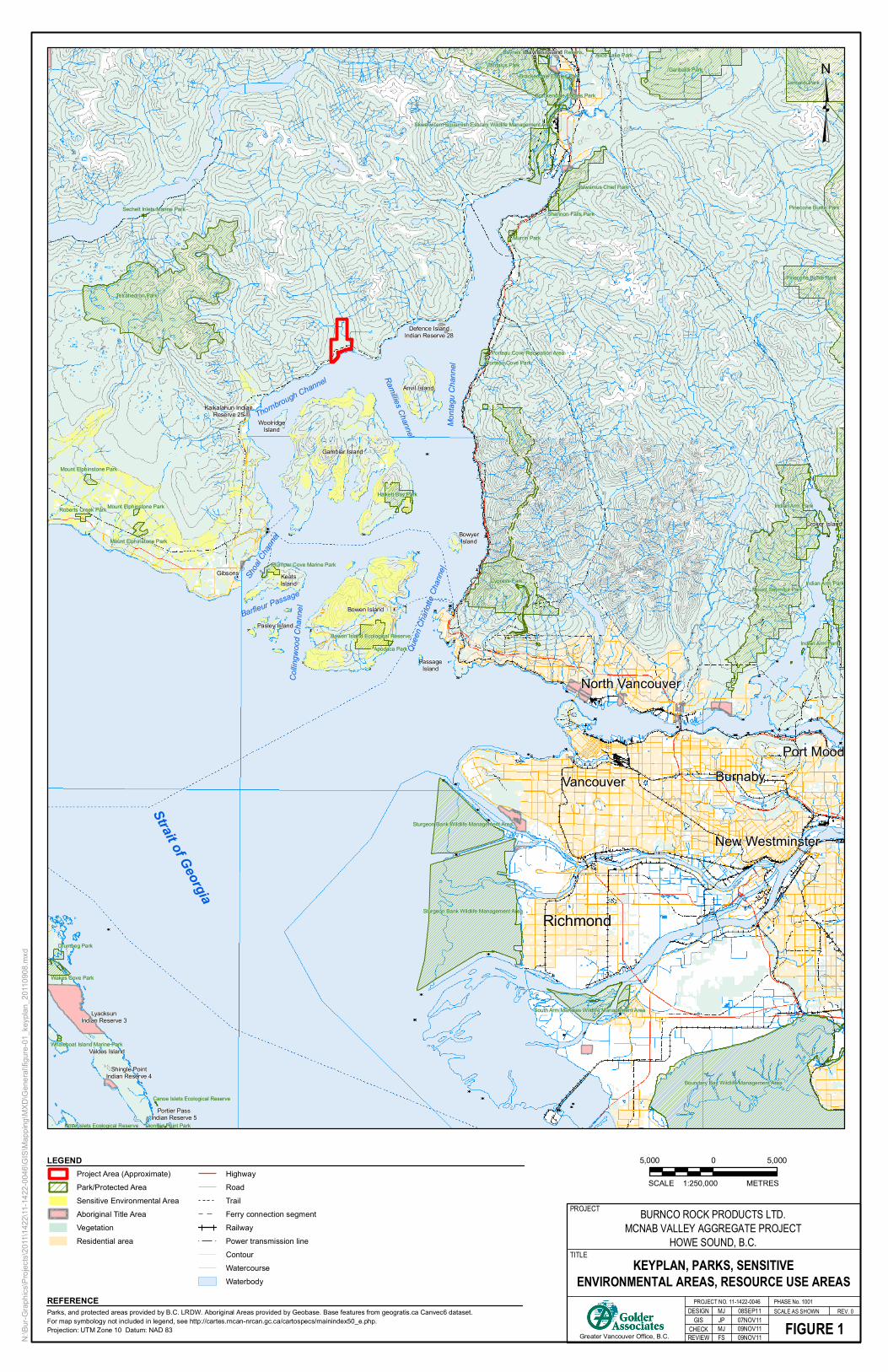
Tetrahedron Park
Boundary Bay Wildlife Management Area
Cypress ParkMount Seymour Park
Garibaldi Park
Sturgeon Bank Wildlife Management Area
Garibaldi Park
Tantalus Park
Pinecone Burke Park
Indian Arm Park
Indian Arm Park
Sturgeon Bank Wildlife Management Area
Pinecone Burke Park
Stawamus Chief Park
Indian Arm Park
Halkett Bay Park
Brackendale Eagles Park
South Arm Marshes Wildlife Management Area
Bowen Island Ecological Reserve
Skwelwil’em Squamish Estuary Wildlife Management Area
Brackendale Eagles Park
Wakes Cove Park
Shannon Falls Park
Alice Lake Park
Drumbeg Park
Mount Elphinstone Park
Porteau Cove Park
Plumper Cove Marine Park
Mount Elphinstone Park
Roberts Creek Park
Murrin Park
Baynes Island Ecological Reserve
Dionisio Point Park
Apodaca Park
Mount Elphinstone Park
Whaleboat Island Marine Park
Sechelt Inlets Marine Park
Porteau Cove Recreation Area
Canoe Islets Ecological Reserve
Rose Islets Ecological Reserve
Richmond
Burnaby
Gibsons
Vancouver
Port Mood
Anvil Island
KeatsIsland
Bowen Island
Valdes Island
Baynes Island
BowyerIsland
Croker Island
Pasley Island
Gambier Island
PassageIsland
New Westminster
North Vancouver
WoolridgeIsland
Kaikalahun IndianReserve 25
Shingle PointIndian Reserve 4
Shoa
l Cha
nnel
Mo
nta
gu C
han
nel
Barfleur Passage
Strait of Georgia
Ram
illies Channel
Thornbrough Channel
Que
en C
harlo
tte C
hann
el
Co
lling
woo
d C
han
nel
Defence IslandIndian Reserve 28
Portier PassIndian Reserve 5
LyacksunIndian Reserve 3
400
200
600
100
800
300
1000
500
700
900
1200
1100
1400
1600
1300
1800
1500
20002200 2400
1700
1200
1200
800
1200
1200
1600
400
1600
1400
1400
1600
1600
900
1400
600
200
200
1600
1500
1200
1400
1700
1400
1100
800
400
1500
1000
1200
1400
600
300
1400
1800
100
1600
1800
1600
1400
200
1100
140014
00
800
1200
1600
1000
1400
1600
600
100
600
100
1400
400
600
1600
1000
1100700
1400
1800
400
1200
1200
200
1400
1400
1400
800
800
1400
200
1500
400
1400
100
100
800
200
2000
200
1000
200
1100
200
100
1600
100
1800
1500
1200
500
1400
1400
400
1200
1000
1000
12001800
100
1000
1400
1000
1600800
1400
600
700
1800
100
1200
1200
1800
1300
600
1000
2000
1400
1600
800
200
1200
1200
800
1600
200
100
1000
400
400
1800
300
100
1600
1200
1000
1200
1200
1400
1200
1300
1300
100
1400
600
1200
1000
1200
200
1400
100
400
400
400
900
1600
600
1200
100
400
800
1200
1000
1600
600
1400
400
1600
200
1400
1600
1200
1300
200
1000
700
1400
1300
1400
1200
800
1400
200
1400
1800
900
200
1200
1200
200
1000
1000
1800
1600
1400
1200
1400
1400
1400
500
300
1800
1200
400
1400
400
1300
100
1400
1400
1200
600
200
200
1100
600
1400
200
1300
200
1200
800
1400
1300
100
200
1000
1000
1200
100
1000
500
1600
100
1300
1100
800
700
200
1100
400
600
1200
1100
800
1200
1800
1200
600
1100
1400
1400
1400
1800
1400
1200
800
200
100
1000
1400
600
1800
1200
200
1200
300
1300
200
1400
400
1100
400
800
1400
1400
1200
1400
100
1200
1000
1800
1600
700
1200
1800
600
1000
1600
1100
1000
1500
1200
1000
1000
400
1200
1600
400
1400
200
1200
1300
1200
800
900
1200
800
1100
6001300
1200
200
1200
1400
100
100
200
1600
1100
600
1200
1200
400
1100
1200
1800
200
100
300
1100
1200
1000
1600
1100
1200
1400
1000
200
1000
1400
1000
800
100
600
200
100
1400
1600
400
1200
400
400
800
1200
1400
1200
1000
1200
1200
1600
200
1200300
40013
00
1200
1200
1400
1200
1200
1200
900
1200
1200
1000
1800200
1400
1200
1400
1200
5001400
1600
200
1400
1400
1200
120014
00
1800
1200
1000
600
300
1200
400
1600
600
1000
300
800
1600
1200
1400
1400
1200
100
1000
100
800
300
1200
1400
600
400
1200
1200
1200
1400
200
600
100
1400
1400
1200
200
1000
1800
1200
1200
1300
1000
200
1000
1400
1400
1400
1200
200
1200
1400
200
1400
1100
1200
1400
1200
1000
1000
1200
1400
1600
200
200
1600
1000
1600
1600
1200
1300
1200
1600
1200
200
1000
800
800
1400
1000
1600
400
1200
600
1600
1200
400
200
1200
1800
1400
500
1200
1400
100
1100
1600
400
1300
1600
1600
600
1000
1400
200
400
1400
1000
1600
400
200
100
1000
1200
1200
100
100
1000
1200
200
1400
1300
N:\B
ur-G
raph
ics\
Pro
ject
s\20
11\1
422\
11-1
422-
0046
\GIS
\Map
ping
\MXD
\Gen
eral
\figu
re-0
1_ke
ypla
n_20
1109
08.m
xd
Parks, and protected areas provided by B.C. LRDW. Aboriginal Areas provided by Geobase. Base features from geogratis.ca Canvec6 dataset. For map symbology not included in legend, see http://cartes.rncan-nrcan.gc.ca/cartospecs/mainindex50_e.php. Projection: UTM Zone 10 Datum: NAD 83
REFERENCEREV. 0
Greater Vancouver Office, B.C.
DESIGN
KEYPLAN, PARKS, SENSITIVEENVIRONMENTAL AREAS, RESOURCE USE AREAS
FIGURE 1
PROJECT NO. 11-1422-0046SCALE AS SHOWN
PROJECT
TITLE
GIS
REVIEW
MJ 08SEP11
CHECK
BURNCO ROCK PRODUCTS LTD.MCNAB VALLEY AGGREGATE PROJECT
HOWE SOUND, B.C.
JP 07NOV11
5,000 0 5,000
METRES1:250,000SCALE
PHASE No. 1001
LEGENDProject Area (Approximate)
Park/Protected Area
Sensitive Environmental Area
Aboriginal Title Area
Vegetation
Residential area
Highway
Road
Trail
Ferry connection segment
Railway
Power transmission line
Contour
Watercourse
Waterbody
MJ 09NOV11FS 09NOV11

Overburden Stockpiled onNorth Side of BC Hydro Right of Way
Culvert
Training Berm
Overburden andOversize Stockpile
on South Side of Berm
Extent of Existing Flood Protection
To Match ExistingRoad Grade
Culvert Equipped withOverflow Valve Control
Culvert
Surface Collection Ditch andCompensation Fish Channel
Culvert
Temporary FinesStockpile
McNab Creek
GroundwaterChannel
Existing Shop
Processing Plant andProduct Stockpiles
Conveyor to Load-out
Existing Dock
Surface Collection Ditch andCompensation Fish ChannelTie-in to Existing Channel
Proposed BargeLoad-out (Typ.)
Proposed Channel Plug
Year 10
Year 20
Year 7
Year 15Year 17
Year 12Year 3
Year 2
Year 5
Year 4
Year 1
471000
471000
471500
471500
472000
472000
5489
500
5489
500
5490
000
5490
000
5490
500
5490
500
5491
000
5491
000
N:\B
ur-G
raph
ics\
Pro
ject
s\20
11\1
422\
11-1
422-
0046
\GIS
\Map
ping
\MXD
\Gen
eral
\100
1\fig
ure-
02_s
itepl
an.m
xd
Base features from TRIM Positional data. Additional detailed site features provided by McElhanney. Imageryobtained from Google Earth Pro (c 2010). Projection: UTM Zone 10 Datum: NAD 83
REFERENCE
Proposed Aggregate Pit AreaYear 1Year 2Year 3
Year 4Year 5Year 7Year 10Year 12
Year 15Year 17Year 20
BURNCO Property Boundary
Proposed Mine FeaturesExisting Barge Loading & Dock
Existing Warehouse & Maintenance Building
ConveyorBardge Load-OutDikeTraining Berm
75 m Creek Top of Bank OffsetSurface Collection and Compensation Fish ChannelTransmission LineContour - 100 m
Contour - 20 m
Watercourse (Surveyed and TRIM)
Culvert
REV. 0
Greater Vancouver Office, B.C.
DESIGN
PROPOSED CONCEPTUAL SITE LAYOUT
FIGURE 2
PROJECT NO. 11-1422-0046SCALE AS SHOWN
PROJECT
TITLE
GIS
REVIEW
MJ 08SEP11
CHECK
BURNCO ROCK PRODUCTSAGGREGATE PROJECT
HOWE SOUND, B.C.
JP 04NOV11
200 0 200
METRES1:6,000SCALE
PHASE No. 1001
LEGEND
MJ 09NOV11FS 09NOV11

Boundary Bay Wildlife Management Area
Cypress ParkMount Seymour Park
Garibaldi Park
Sturgeon Bank Wildlife Management Area
Garibaldi Park
Tantalus Park
Pinecone Burke Park
Indian Arm Park
Indian Arm Park
Sturgeon Bank Wildlife Management Area
Pinecone Burke Park
Stawamus Chief Park
Indian Arm Park
Halkett Bay Park
Brackendale Eagles Park
South Arm Marshes Wildlife Management Area
Bowen Island Ecological Reserve
Skwelwil’em Squamish Estuary Wildlife Management Area
Brackendale Eagles Park
Shannon Falls Park
Alice Lake Park
Porteau Cove Park
mper Cove Marine Park
Murrin Park
Baynes Island Ecological Reserve
Apodaca Park
Porteau Cove Recreation Area
Richmond
Surrey
Langely
CoquitlamBurnabyVancouver
Port Moody
Anvil Island
KeatsIsland
Bowen Island
Baynes Island
BowyerIsland
Croker Island
sland
Gambier Island
PassageIsland
New Westminster
North Vancouver
ged
l
Mo
nta
gu C
han
nel
assage
Ram
illies Channel
brough Channel
Que
en C
harlo
tte C
hann
el
Co
lling
woo
d C
han
nel
Defence IslandIndian Reserve 28
N:\B
ur-G
raph
ics\
Pro
ject
s\20
11\1
422\
11-1
422-
0046
\GIS
\Map
ping
\MXD
\Gen
eral
\100
1\fig
ure-
03_p
ropo
sed_
barg
e_ro
ute.
mxd
Parks, and protected areas provided by B.C. LRDW. Aboriginal Areas provided by Geobase. Base features from geogratis.ca Canvec6 dataset. For map symbology not included in legend, see http://cartes.rncan-nrcan.gc.ca/cartospecs/mainindex50_e.php. Projection: UTM Zone 10 Datum: NAD 83
REFERENCEREV. 0
Greater Vancouver Office, B.C.
DESIGN
PROPOSED AND EXISTINGBARGE SHIPPING ROUTES
FIGURE 3
PROJECT NO. 11-1422-0046SCALE AS SHOWN
PROJECT
TITLE
GIS
REVIEW
MJ 07NOV11
CHECK
BURNCO ROCK PRODUCTS LTD.MCNAB VALLEY AGGREGATE PROJECT
HOWE SOUND, B.C.
JP 09NOV11
5,000 0 5,000
METRES1:250,000SCALE
PHASE No. 1001
LEGENDProject Area (Approximate)
Proposed Barging Route
Existing Barging Route
Existing Shipping Navigational Channels
Park/Protected Area
Sensitive Environmental Area
Aboriginal Title Area
Vegetation
Residential area
Highway
Road
Trail
Ferry connection segment
Railway
Power transmission line
Contour
Watercourse
Waterbody
Comox
Tahsis
Sidney
Sayward
Gibsons
Whistler
Ucluelet
Pemberton
View Royal
Gold River
Old Ahousat
Port McNeill
Lake Cowichan
MJ 09NOV11FS 09NOV11

ww = 5.5, d = 1.1
ww = 4.2, d = 0.4
ww = 3.7, d = 0.5
CO(ww = 1.2, d = 0.1)
CO, CT(ww = 3.6, d = 0.3)
ww = 4.1, d = 0.1
ww = 32.0, d = 0.4
Overburden Stockpiled onNorth Side of BC Hydro Right of Way
Culvert
Training Berm
Overburden andOversize Stockpile
on South Side of Berm
Extent of Existing Flood Protection
To Match ExistingRoad Grade
Culvert Equipped withOverflow Valve Control
Culvert
Surface Collection Ditch andCompensation Fish Channel
Culvert
Temporary FinesStockpile
McNab Creek
GroundwaterChannel
Existing Shop
Processing Plant andProduct Stockpiles
Conveyor to Load-out
Existing Dock
Surface Collection Ditch andCompensation Fish ChannelTie-in to Existing Channel
Proposed BargeLoad-out (Typ.)
Proposed Channel Plug
CO(ww = 2.7, d = 0.2)
CO(ww = 1.9, d = 0.2)
CM, CO, CT(ww = 4.3, d = 0.2)
CO, CM, CH, PK, ST(ww = 28.0, d = 0.7)
CO(ww = 2.1, d = 0.1)
CT(ww = 1.0, d = 0.1)
CT(ww = 2.7, d = 0.1)
CT(ww = 1.5, d = 0.1)
PK
471000
471000
471500
471500
472000
472000
5489
500
5489
500
5490
000
5490
000
5490
500
5490
500
5491
000
5491
000
N:\B
ur-G
raph
ics\
Pro
ject
s\20
11\1
422\
11-1
422-
0046
\GIS
\Map
ping
\MXD
\Gen
eral
\100
1\fig
ure-
04_a
rea_
wat
erco
urse
_cla
ssifi
catio
n.m
xd
Base features from TRIM Positional data. Additional detailed site features provided by McElhanney. Imageryobtained from Google Earth Pro (c 2010). Projection: UTM Zone 10 Datum: NAD 83
REFERENCE
BURNCO Property Boundary
Proposed Mine Features
Existing Barge Loading & Dock
Existing Warehouse & Maintenance BuildingConveyor
Bardge Load-Out
DikeTraining Berm
75 m Creek Top of Bank Offset
Surface Collection and Compensation Fish ChannelTransmission Line
Contour - 100 m
Contour - 20 mPermanent Watercourse
Seasonal/Ephemeral Watercourse
Tidal Influenced WatercourseExtent of Anadromy
Upper Boundary of SpeciesCulvert
REV. 0
Greater Vancouver Office, B.C.
DESIGN
AREA WATERCOURSE CLASSIFICATION
FIGURE 4
PROJECT NO. 11-1422-0046SCALE AS SHOWN
PROJECT
TITLE
GIS
REVIEW
RH 04NOV11
CHECK
BURNCO ROCK PRODUCTSAGGREGATE PROJECT
HOWE SOUND, B.C.
JP 07NOV11
200 0 200
METRES1:6,000SCALE
PHASE No. 1001
LEGEND
MJ 09NOV11 FS 09NOV11
ww Wetted Width (low flow)
d Channel Depth (low flow)

Tetrahedron Park
Boundary Bay Wildlife Management Area
Cypress ParkMount Seymour Park
Garibaldi Park
Sturgeon Bank Wildlife Management Area
Garibaldi Park
Tantalus Park
Pinecone Burke Park
Indian Arm Park
Indian Arm Park
Sturgeon Bank Wildlife Management Area
Pinecone Burke Park
Stawamus Chief Park
Indian Arm Park
Halkett Bay Park
Brackendale Eagles Park
South Arm Marshes Wildlife Management Area
Bowen Island Ecological Reserve
Skwelwil’em Squamish Estuary Wildlife Management Area
Brackendale Eagles Park
Wakes Cove Park
Shannon Falls Park
Alice Lake Park
Drumbeg Park
Mount Elphinstone Park
Porteau Cove Park
Plumper Cove Marine Park
Mount Elphinstone Park
Roberts Creek Park
Murrin Park
Baynes Island Ecological Reserve
Dionisio Point Park
Apodaca Park
Mount Elphinstone Park
Whaleboat Island Marine Park
Sechelt Inlets Marine Park
Porteau Cove Recreation Area
Canoe Islets Ecological Reserve
Rose Islets Ecological Reserve
Richmond
Tidal Water Resource Management Areas (28-A) - Harvest: -Salmon fisheries (gillnet, seine, troll) -Shrimp -Intertidal clams -Crab -Euphausiids -Groundfish -Smelt.
Burnaby
Gibsons
Vancouver
Port Mood
Anvil Island
KeatsIsland
Bowen Island
Valdes Island
Baynes Island
BowyerIsland
Croker Island
Pasley Island
Gambier Island
PassageIsland
New Westminster
North Vancouver
WoolridgeIsland
Kaikalahun IndianReserve 25
Shingle PointIndian Reserve 4
Shoa
l Cha
nnel
Mo
nta
gu C
han
nel
Barfleur Passage
Strait of Georgia
Ram
illies Channel
Thornbrough Channel
Que
en C
harlo
tte C
hann
el
Co
lling
woo
d C
han
nel
Defence IslandIndian Reserve 28
Portier PassIndian Reserve 5
LyacksunIndian Reserve 3
28-2
28-1
28-3
28-5
28-7
28-4
28-12
28-10 28-11
28-8
28-6
28-13
28-9
28-14
400
200
600
100
800
300
1000
500
700
900
1200
1100
1400
1600
1300
1800
1500
20002200 2400
1700
1200
1200
800
1200
1200
1600
400
1600
1400
1600
1600
900
1400
600
200
200
1600
1500
1400
1700
1400
1100
800
400
1500
1000
1200
1400
600
300
1400
1800
100
1600
1800
1600
1400
200
1100
140014
00
800
1600
1000
1400
1600
600
100
600
100
1400
400
600
1600
1000700
1400
1800
400
1200
1200
200
1400
1400
1400
800
800
1400
200
1500
400
1400
100
100
800
200
2000
200
1000
200
1100
200
100
1600
100
1800
1500
1200
500
1400
1400
400
1000
1000
12001800
100
1000
1400
1000
1600800
1400
600
700
1800
100
1200
1200
1800
600
1000
2000
1400
1600
200
1200
1200
800
1600
200
100
1000
400
400
1800
300
100
1600
1200
1000
1200
1200
1200
1300
1300
100
1400
600
1200
1000
1200
200
100
400
400
400
900
1600
600
1200
100
400
800
1200
1000
1600
600
1400
400
1600
200
1600
1200
1300
200
1000
700
1400
1300
1400
1200
800
1400
200
1400
1800
900
200
1200
1200
200
1000
1000
1800
1600
1400
1200
1400
1400
500
300
1800
1200
400
1400
400
1300
100
1400
1400
1200
600
200
200
600
1400
200
1300
200
1200
800
1300
100
200
1000
1000
1200
100
500
1600
100
1300
1100
800
700
200
400
600
1200
1100
1200
1800
1200
600
1100
1400
1400
1400
1800
1400
1200
800
200
100
1000
1400
600
1800
200
1200
300
1300
200
400
1100
400
800
1400
1400
1200
1400
100
1200
1000
1800
1600
700
1200
1800
600
1000
1600
1100
1000
1500
1200
1000
400
1200
1600
400
1400
200
1300
1200
800
900
1200
800
1100
6001300
1200
200
1200
1400
100
100
200
1600
1100
600
1200
1200
400
1100
1200
1800
200
100
300
1100
1200
1000
1600
1200
1400
1000
200
1000
1400
1000
800
100
600
200
100
1400
1600
400
1200
400
400
800
1200
1400
1200
1000
1200
1600
200
1200300
40013
00
1200
1200
1400
1200
1200
1200
900
1200
1200
1800200
1400
1200
1400
1200
5001400
1600
200
1400
1400
1200
120014
00
1800
1200
600
300
400
1600
600
1000
300
800
1600
1200
1400
1400
1200
100
100
800
300
1200
1400
600
400
1200
1200
1200
200
600
100
1400
1400
1200
200
1000
1800
1200
1200
1300
1000
200
1000
1400
1400
1400
1200
200
1200
1400
200
1400
1100
1200
1400
1200
1000
1000
1200
1400
1600
200
200
1600
1000
1600
1600
1300
1200
1600
1200
200
1000
800
800
1400
1000
1600
400
1200
600
1600
1200
400
200
1200
1800
1400
500
1200
1400
100
1100
1600
4001600
1600
600
1000
1400
200
400
1400
1000
1600
400
200
100
1200
1200
100
100
1000
1200
200
1400
1300
N:\B
ur-G
raph
ics\
Pro
ject
s\20
11\1
422\
11-1
422-
0046
\GIS
\Map
ping
\MXD
\Gen
eral
\100
1\fig
ure-
05_r
esou
rce_
fishe
ries.
mxd
Parks, and protected areas provided by B.C. LRDW. Aboriginal Areas provided by Geobase. Base features from geogratis.ca Canvec6 dataset. For map symbology not included in legend, see http://cartes.rncan-nrcan.gc.ca/cartospecs/mainindex50_e.php. Projection: UTM Zone 10 Datum: NAD 83
REFERENCEREV. 0
Greater Vancouver Office, B.C.
DESIGN
RESOURCE AND FISHERIES AREA
FIGURE 5
PROJECT NO. 11-1422-0046SCALE AS SHOWN
PROJECT
TITLE
GIS
REVIEW
MJ 08SEP11
CHECK
BURNCO ROCK PRODUCTS LTD.MCNAB VALLEY AGGREGATE PROJECT
HOWE SOUND, B.C.
JP 07NOV11
5,000 0 5,000
METRES1:250,000SCALE
PHASE No. 1001
LEGENDProject Area (Approximate)
DFO Management Area
Park/Protected Area
Sensitive Environmental Area
Aboriginal Title Area
Vegetation
Residential area
Highway
Road
Trail
Ferry connection segment
Railway
Power transmission line
Contour
Watercourse
Waterbody
MJ 09NOV11FS 09NOV11

BURNCO AGGREGATE PROPERTY
December 16, 2011 Report No. 11-1422-0046
APPENDIX A Photographs

APPENDIX A Photographs
December 16, 2011 Project No. 11-1422-0046 1/3
Photograph 1: McNab valley, view north, April 6, 2009.
Photograph 2: McNab valley access road and maintenance facility, view north, April 6, 2009.

APPENDIX A Photographs
December 16, 2011 Project No. 11-1422-0046 2/3
Photograph 3: Boat access dock at McNab, September 9, 2009.
Photograph 4: McNab valley foreshore, May 28, 2009.

APPENDIX A Photographs
December 16, 2011 Project No. 11-1422-0046 3/3
Photograph 5: McNab property constructed ground-water channel, view south-southeast, April 6, 2009.
Photograph 6: McNab Creek mainstem, south view – downstream, October 19, 2009.
\\bur1-s-filesrv2\final\2011\1422\11-1422-0046\rep 1216_11 burnco aggregate project description_final\app a_photographs_ mcnab site.docx

Golder Associates Ltd.
500 - 4260 Still Creek Drive
Burnaby, British Columbia, V5C 6C6
Canada
T: +1 (604) 296 4200