Embed Size (px)
Citation preview
RemoteView Geospatial Intelligence Software
AnAlyze With ConfidenCe
From imagery analysis to precision positioning and 3D visualization, RemoteView is the proven solution for situational understanding and interoperability. As the geospatial intelligence solution of choice within 26 countries around the globe, RemoteView is used across a broad spectrum of industries including: military and defense, border security, disaster relief, natural resource management, civil engineering, ecosystem monitoring, city planning, environmental engineering, oil and gas exploration, real estate, utility companies and more.
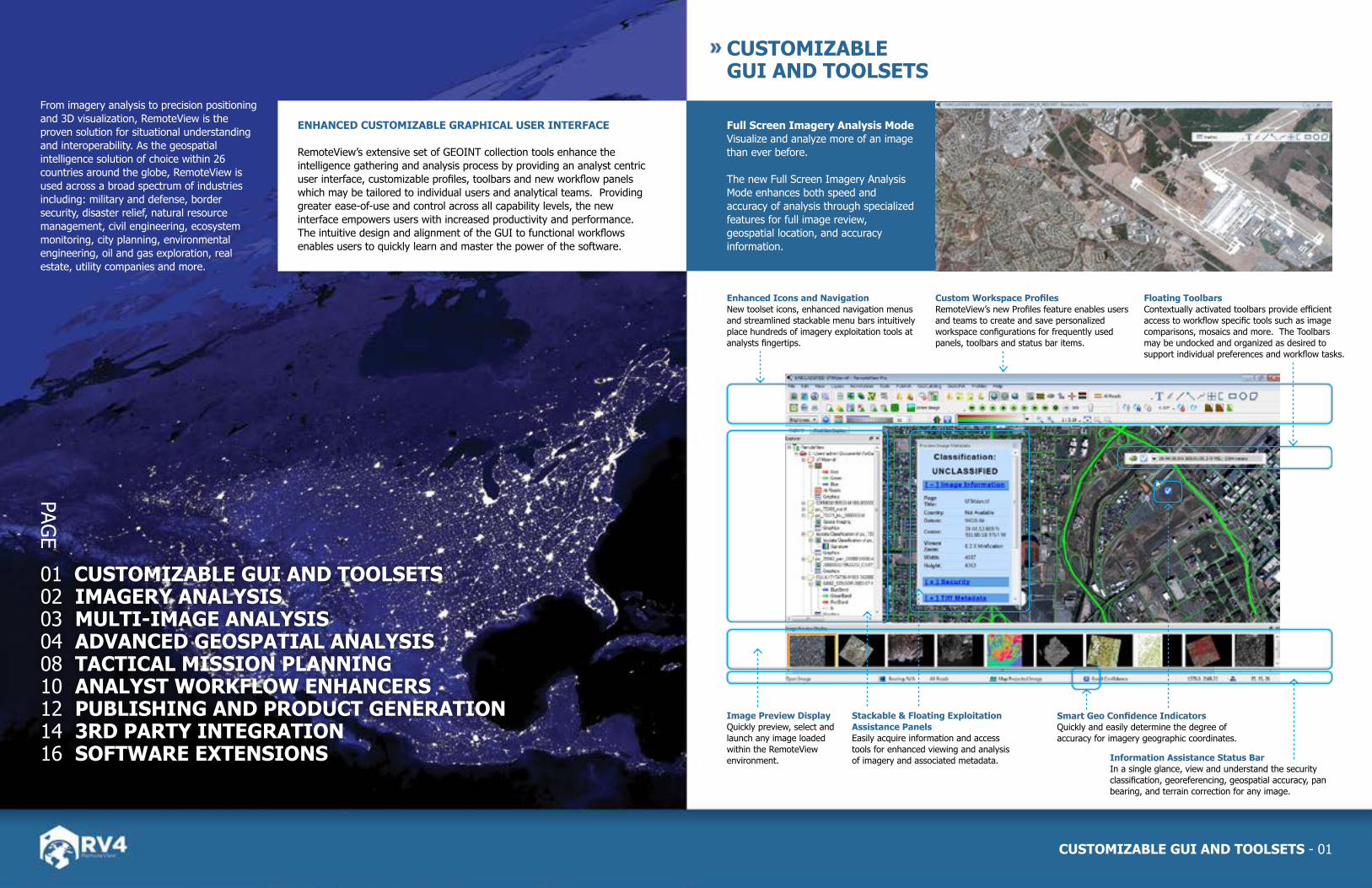
full Screen imagery Analysis Mode Visualize and analyze more of an image than ever before.
The new Full Screen Imagery Analysis Mode enhances both speed and accuracy of analysis through specialized features for full image review, geospatial location, and accuracy information.
Custom Workspace ProfilesRemoteView’s new Profiles feature enables users and teams to create and save personalized workspace configurations for frequently used panels, toolbars and status bar items.
floating toolbarsContextually activated toolbars provide efficient access to workflow specific tools such as image comparisons, mosaics and more. The Toolbars may be undocked and organized as desired to support individual preferences and workflow tasks.
enhanced icons and navigationNew toolset icons, enhanced navigation menus and streamlined stackable menu bars intuitively place hundreds of imagery exploitation tools at analysts fingertips.
Stackable & floating exploitation Assistance PanelsEasily acquire information and access tools for enhanced viewing and analysis of imagery and associated metadata.
image Preview displayQuickly preview, select and launch any image loaded within the RemoteView environment. information Assistance Status Bar
In a single glance, view and understand the security classification, georeferencing, geospatial accuracy, pan bearing, and terrain correction for any image.
Smart Geo Confidence IndicatorsQuickly and easily determine the degree of accuracy for imagery geographic coordinates.
CuStoMizABle Gui And toolSetS
CuStoMizABle Gui And toolSetS - 01
enhAnCed CuStoMizABle GrAPhiCAl uSer interfACe
RemoteView’s extensive set of GEOINT collection tools enhance the intelligence gathering and analysis process by providing an analyst centric user interface, customizable profiles, toolbars and new workflow panels which may be tailored to individual users and analytical teams. Providing greater ease-of-use and control across all capability levels, the new interface empowers users with increased productivity and performance. The intuitive design and alignment of the GUI to functional workflows enables users to quickly learn and master the power of the software.
01 CuStoMizABle Gui And toolSetS02 iMAGery AnAlySiS03 Multi-iMAGe AnAlySiS04 AdVAnCed GeoSPAtiAl AnAlySiS08 tACtiCAl MiSSion PlAnninG10 AnAlySt WorKfloW enhAnCerS12 PuBliShinG And ProduCt GenerAtion14 3rd PArty inteGrAtion16 SoftWAre eXtenSionS
PAGE
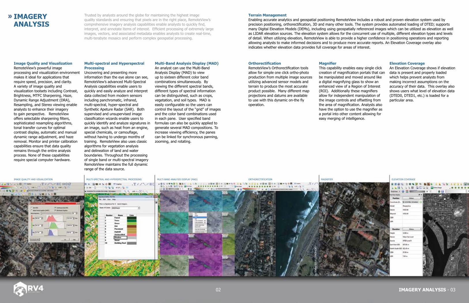
image Quality and VisualizationRemoteView’s powerful image processing and visualization environment makes it ideal for applications that require speed, precision, and clarity. A variety of image quality and visualization toolsets including Contrast, Brightness, MTFC Sharpening, Haze, Dynamic Range Adjustment (DRA), Resampling, and Stereo viewing enable analysts to enhance their imagery to gain perspective. RemoteView offers selectable sharpening filters, sophisticated resampling algorithms, tonal transfer curves for optimal contrast display, automatic and manual dynamic range adjustment, and haze removal. Monitor and printer calibration capabilities ensure that data quality remains through the entire analysis process. None of these capabilities require special computer hardware.
Multi-Band Analysis display (MAd)An analyst can use the Multi-Band Analysis Display (MAD) to view up to sixteen different color band combinations simultaneously. By viewing the different spectral bands, different types of spectral information can be distinguished, such as crops, vegetation, and soil types. MAD is easily configurable so the users can control the layout of the “grid” of images and the color band combinations used in each pane. User specified band formulas can also be quickly applied to generate several MAD compositions. To increase viewing efficiency, the panes can be linked for synchronous panning, zooming, and rotating.
Orthorectification RemoteView’s Orthorectification tools allow for simple one click ortho-photo production from multiple image sources utilizing advanced sensor models and terrain to produce the most accurate product possible. Many different map projections and datums are available to use with this dynamic on-the fly operation.
MagnifierThis capability enables easy single click creation of magnification portals that can be manipulated and moved around like a digital magnifying glass to show an enhanced view of a Region of Interest (ROI). Additionally these magnifiers allow for independent manipulation of the image controls and offsetting from the area of magnification. Analysts also have the option to use the magnifier as a portal into other content allowing for easy merging of intelligence.
terrain ManagementEnabling accurate analytics and geospatial positioning RemoteView includes a robust and proven elevation system used by precision positioning, orthorectification, 3D and many other tools. The system provides automated loading of DTED; supports many Digital Elevation Models (DEMs), including using geospatially referenced images which can be utilized as elevation as well as LIDAR elevation sources. The elevation system allows for the concurrent use of multiple, different elevation types and levels of detail. When utilizing elevation, RemoteView is able to provide a higher confidence in positioning operations and reporting allowing analysts to make informed decisions and to produce more accurate reports. An Elevation Coverage overlay also indicates whether elevation data provides full coverage for areas of interest.
iMAGery AnAlySiS
Trusted by analysts around the globe for maintaining the highest image quality standards and ensuring that pixels are in the right place, RemoteView’s comprehensive imagery analysis capabilities enable analysts to quickly find, interpret, and annotate items of interest. Efficient processing of extremely large images, vectors, and associated metadata enables analysts to create real-time, multi-terabyte mosaics and perform complex geospatial processing.
Multi-spectral and hyperspectral ProcessingUncovering and presenting more information than the eye alone can see, RemoteView’s advanced Multi-Spectral Analysis capabilities enable users to quickly and easily analyze and interpret data collected from modern sensors including panchromatic, infrared, multi-spectral, hyper-spectral and Synthetic Apeture Radar (SAR). Both supervised and unsupervised image classification wizards enable users to quickly identify and analyze signatures in an image, such as heat from an engine, special chemicals, or camouflage, without having to undergo months of training. RemoteView also uses classic algorithms for vegetation analysis and delineation of land and water boundaries. Throughout the processing of single band or multi-spectral imagery RemoteView maintains the full dynamic range of the data source.
iMAGery AnAlySiS - 03
IMAGE QUALITy AND VISUALIzATION MULTI-SPECTRAL AND HyPERSPECTRAL PROCESSING MULTI-BAND ANALySIS DISPLAy (MAD) ORTHORECTIFICATION MAGNIFIER ELEVATION COVERAGE
elevation CoverageAn Elevation Coverage shows if elevation data is present and properly loaded which helps prevent analysts from making incorrect assumptions on the accuracy of their data. This overlay also shows users what level of elevation data (DTED0, DTED1, etc.) is loaded for a particular area.
02
ORTH
ORECTIFIED
IMAG
E
ORIG
INAL IM
AGE
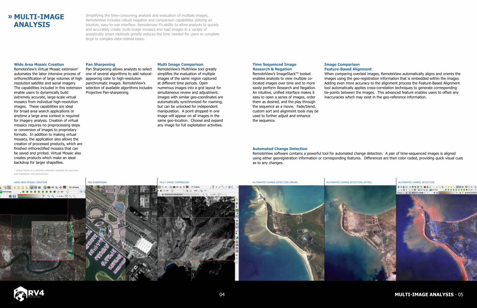
Simplifying the time-consuming analysis and evaluation of multiple images, RemoteView includes robust negation and comparison capabilities utilizing an intuitive, easy-to-use interface. Remoteview 4’s ability to allow analysts to quickly and accurately create multi-image mosaics and load images in a variety of analytically smart methods greatly reduces the time needed for users to complete large or complex data-related tasks.
Wide Area Mosaic Creation RemoteView’s Virtual Mosaic extension1 automates the labor intensive process of orthorectification of large volumes of high resolution satellite and aerial imagery. The capabilities included in this extension enable users to dynamically build extremely accurate, large-scale virtual mosaics from individual high-resolution images. These capabilities are ideal for broad area search applications or anytime a large area context is required for imagery analysis. Creation of virtual mosaics requires no preprocessing steps or conversion of images to proprietary formats. In addition to making virtual mosaics, the application also allows the creation of processed products, which are finished orthorectified mosaics that can be saved and printed. Virtual Mosaic also creates products which make an ideal backdrop for larger shapefiles.
Pan Sharpening Pan Sharpening allows analysts to select one of several algorithms to add natural- appearing color to high-resolution panchromatic images. RemoteView’s selection of available algorithms includes Projective Pan-sharpening.
Multi image Comparison RemoteView’s MultiView tool greatly simplifies the evaluation of multiple images of the same region captured at different time periods. Open numerous images into a grid layout for simultaneous review and adjustment. Images with similar geo-coordinates are automatically synchronized for roaming, but can be unlocked for independent manipulation. A point dropped in one image will appear on all images in the same geo-location. Choose and expand any image for full exploitation activities.
time Sequenced image research & negationRemoteView’s ImageStackTM toolset enables analysts to view multiple co-located images over time and to more easily perform Research and Negation. An intuitive, unified interface makes it easy to open a series of images, order them as desired, and the play through the sequence as a movie. Fade/blend, custom sort and alignment tools may be used to further adjust and enhance the sequence.
image Comparison feature-Based AlignmentWhen comparing overlaid images, RemoteView automatically aligns and orients the images using the geo-registration information that is embedded within the images. Adding even more accuracy to the alignment process the Feature-Based Alignment tool automatically applies cross-correlation techniques to generate corresponding tie-points between the images. This advanced feature enables users to offset any inaccuracies which may exist in the geo-reference information.
Multi-iMAGeAnAlySiS
Automated Change detectionRemoteView software contains a powerful tool for automated change detection. A pair of time-sequenced images is aligned using either georegistration information or corresponding features. Differences are then color coded, providing quick visual cues as to any changes.
Multi-iMAGe AnAlySiS - 05
1 Virtual Mosaic is a software extension available for purchase and installation with RemoteView
WIDE AREA MOSAIC CREATION PAN SHARPENING MULTI IMAGE COMPARISON AUTOMATED CHANGE DETECTION (PRIOR) AUTOMATED CHANGE DETECTION (AFTER) AUTOMATED CHANGE DETECTION
04
Intelligence community, warfighter and commercial analysts alike all benefit from RemoteView’s broad array of trusted, accurate, field-proven geospatial analysis tools such as GIS and Vectorized Layer tools, 3D visualization, high resolution LIDAR analysis capabilities and more. Essential for enhanced mission planning and operations support across disciplines, these capabilities enable users to enhance their imagery to gain perspective.
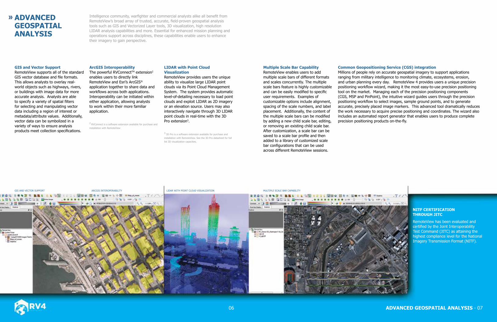
GiS and Vector SupportRemoteView supports all of the standard GIS vector database and file formats. This allows analysts to overlay real- world objects such as highways, rivers, or buildings with image data for more accurate analysis. Analysts are able to specify a variety of spatial filters for selecting and manipulating vector data including a region of interest or metadata/attribute values. Additionally, vector data can be symbolized in a variety of ways to ensure analysis products meet collection specifications.
ArcGiS interoperabilityThe powerful RVConnectTM extension2 enables users to directly link RemoteView and Esri’s ArcGIS® application together to share data and workflows across both applications. Interoperability can be initiated within either application, allowing analysts to work within their more familiar application.
2 RVConnect is a software extension available for purchase and installation with RemoteView
lidAr with Point Cloud VisualizationRemoteView provides users the unique ability to visualize large LIDAR point clouds via its Point Cloud Management System. The system provides automatic level-of-detailing necessary to load point clouds and exploit LIDAR as 2D imagery or an elevation source. Users may also interactively navigate through 3D LIDAR point clouds in real-time with the 3D Pro extension3.
3 3D Pro is a software extension available for purchase and installation with RemoteView. See the 3D Pro datasheet for full list 3D visualization capacities.
Multiple Scale Bar CapabilityRemoteView enables users to add multiple scale bars of different formats and scales concurrently. The multiple scale bars feature is highly customizable and can be easily modified to specific user requirements. Examples of customizable options include alignment, spacing of the scale numbers, and label placement. Additionally, the content of the multiple scale bars can be modified by adding a new child scale bar, editing, or removing an existing child scale bar. After customization, a scale bar can be saved to a scale bar profile and then added to a library of customized scale bar configurations that can be used across different RemoteView sessions.
Common Geopositioning Service (CGS) integration Millions of people rely on accurate geospatial imagery to support applications ranging from military intelligence to monitoring climate, ecosystems, erosion, and urban planning every day. RemoteView 4 provides users a unique precision positioning workflow wizard, making it the most easy-to-use precision positioning tool on the market. Managing each of the precision positioning components (CGS, MSP and PinPoint), the intuitive wizard guides users through the precision positioning workflow to select images, sample ground points, and to generate accurate, precisely placed image markers. This advanced tool dramatically reduces the work necessary to acquire precise positioning and coordinates. The wizard also includes an automated report generator that enables users to produce complete precision positioning products on-the-fly.
nitf CertifiCAtion throuGh JitC
AdVAnCed GeoSPAtiAl AnAlySiS
RemoteView has been evaluated and certified by the Joint Interoperability Test Command (JITC) as attaining the highest compliance level for the National Imagery Transmission Format (NITF).
AdVAnCed GeoSPAtiAl AnAlySiS - 07
GIS AND VECTOR SUPPORT ARCGIS INTEROPERABILITy LIDAR WITH POINT CLOUD VISUALIzATION MULTIPLE SCALE BAR CAPABILITy
06
In today’s fast-paced, complex and rapidly changing military operations environment, analysts are pushed to the limit to quickly and accurately provide intelligence to enable commanders to execute missions. RemoteView’s enhanced toolset allows for just that, from video analysis and forensics to analyzing for safety of navigation, analysts can respond to a variety of tactical requirements with confidence.
Motion imagery AnalysisWith the growth of unmanned aircraft systems (UAS) as essential resources for surveillance and reconnaissance, RemoteView’s V-TRAC™ software extension5 provides a complete motion imagery exploitation tool that leverages Overwatch’s core competencies in photogrammetry, file management, visualization and reporting5. Analysts can utilize V-TRAC for all phases of motion imagery analysis on a laptop computer. The integrated Player, Report Editor and Image Editor tools automate and speed report creation. By integrating V-TRAC with RemoteView and GeoCatalog Workgroup, analysts are able to search archived videos by location or time and then delve into mission sets to exploit useful information.
5 V-TRAC Basic is a complimentary RemoteView software extension. V-TRAC Pro is a software extension available for purchase and installation with RemoteView to provide full feature motion video analysis capabilities. V-TRAC is controlled on the USML, its export or re-export is subject to the U.S. International Traffic in Arms Regulations [22 CFR 120-130], and it requires a license issued by the U.S. Department of State.
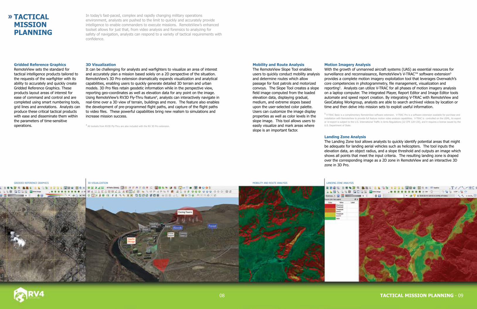
3d VisualizationIt can be challenging for analysts and warfighters to visualize an area of interest and accurately plan a mission based solely on a 2D perspective of the situation. RemoteView’s 3D Pro extension dramatically expands visualization and analytical capabilities, enabling users to quickly generate detailed 3D terrain and urban models. 3D Pro files retain geodetic information while in the perspective view, reporting geo-coordinates as well as elevation data for any point on the image. Using RemoteView’s RV3D Fly-Thru feature4, analysts can interactively navigate in real-time over a 3D view of terrain, buildings and more. The feature also enables the development of pre-programmed flight paths, and capture of the flight paths to video files. These powerful capabilities bring new realism to simulations and increase mission success.
4 All toolsets from RV3D Fly-Thru are also included with the RV 3D Pro extension.
Mobility and route AnalysisThe RemoteView Slope Tool enables users to quickly conduct mobility analysis and determine routes which allow passage for foot patrols and motorized convoys. The Slope Tool creates a slope field image computed from the loaded elevation data, displaying gradual, medium, and extreme slopes based upon the user-selected color palette. Users can customize the image display properties as well as color levels in the slope image. This tool allows users to easily visualize and mark areas where slope is an important factor.
landing zone AnalysisThe Landing Zone tool allows analysts to quickly identify potential areas that might be adequate for landing aerial vehicles such as helicopters. The tool inputs the elevation data, an object radius, and a slope threshold and outputs an image which shows all points that meet the input criteria. The resulting landing zone is draped over the corresponding image as a 2D zone in RemoteView and an interactive 3D zone in 3D Pro.
tACtiCAl MiSSion PlAnninG
Gridded reference GraphicsRemoteView sets the standard for tactical intelligence products tailored to the requests of the warfighter with its ability to accurately and quickly create Gridded Reference Graphics. These products layout areas of interest for ease of command and control and are completed using smart numbering tools, grid lines and annotations. Analysts can produce these critical tactical products with ease and disseminate them within the parameters of time-sensitive operations.
tACtiCAl MiSSion PlAnninG - 09
GRIDDED REFERENCE GRAPHICS 3D VISUALIzATION MOBILITy AND ROUTE ANALySIS LANDING zONE ANALySIS
08
In order to support a wide variety of tasks and operations, analysts must provide accurate geospatially relevant information in an expedited manner, often switching mid-flow between several ongoing jobs. RemoteView software includes tools that speed productivity and analysis capabilities for full spectrum image and data formats.
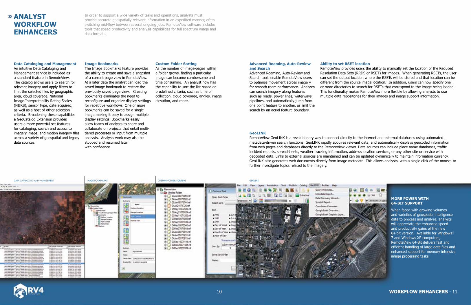
data Cataloging and ManagementAn intuitive Data Cataloging and Management service is included as a standard feature in RemoteView. The catalog allows users to search for relevant imagery and apply filters to limit the selected files by geographic area, cloud coverage, National Image Interpretability Rating Scales (NIIRS), sensor type, date acquired, as well as a host of other selection criteria. Broadening these capabilities a GeoCatalog Extension provides users a more powerful set features for cataloging, search and access to imagery, maps, and motion imagery files across a variety of geospatial and legacy data sources.
image Bookmarks The Image Bookmarks feature provides the ability to create and save a snapshot of a current page view in RemoteView. At a later date the analyst can load the saved image bookmark to restore the previously saved page view. Creating bookmarks eliminates the need to reconfigure and organize display settings for repetitive workflows. One or more bookmarks can be saved for a single image making it easy to assign multiple display settings. Bookmarks easily allow teams of analysts to share and collaborate on projects that entail multi-tiered processes or input from multiple analysts. Analysis work may also be stopped and resumed later with confidence.
Custom folder SortingAs the number of image-pages within a folder grows, finding a particular image can become cumbersome and time consuming. An analyst now has the capability to sort the list based on predefined criteria, such as time of collection, cloud coverage, angles, image elevation, and more.
GeolinKRemoteView GeoLINK is a revolutionary way to connect directly to the internet and external databases using automated metadata-driven search functions. GeoLINK rapidly acquires relevant data, and automatically displays geocoded information from web pages and databases directly to the RemoteView viewer. Data sources can include place name databases, traffic incident reports, spreadsheets, weather tracking information, address location services, or any other site or service with geocoded data. Links to external sources are maintained and can be updated dynamically to maintain information currency. GeoLINK also generates web documents directly from image metadata. This allows analysts, with a single click of the mouse, to further investigate topics related to the imagery.
Ability to set rSet locationRemoteView provides users the ability to manually set the location of the Reduced Resolution Data Sets (RRDS or RSET) for images. When generating RSETs, the user can set the output location where the RSETs will be stored and that location can be different from the source image location. In addition, users can now specify one or more directories to search for RSETs that correspond to the image being loaded. This functionality makes RemoteView more flexible by allowing analysts to use multiple data repositories for their images and image support information.
AnAlySt WorKfloW enhAnCerS
WorKfloW enhAnCerS - 11
Advanced roaming, Auto-review and SearchAdvanced Roaming, Auto-Review and Search tools enable RemoteView users to optimize movement across imagery for smooth roam performance. Analysts can search imagery along features such as roads, power lines, waterways, pipelines, and automatically jump from one point feature to another, or limit the search by an aerial feature boundary.
DATA CATALOGING AND MANAGEMENT IMAGE BOOKMARKS CUSTOM FOLDER SORTING GEOLINK
When faced with growing volumes and varieties of geospatial intelligence data to process and analyze, analysts will appreciate the enhanced speed and productivity gains of the new 64-bit version. Available for Windows® 7 and Windows XP computers, RemoteView 64-Bit delivers fast and efficient handling of large data files and enhanced support for memory intensive image processing tasks.
More PoWer With 64-Bit SuPPort
10
A key feature that sets RemoteView software apart from other geospatial exploitation packages is its powerful publishing and secondary product generation capabilities using a multitude of exportable formats including PDF, PowerPoint, GoogleEarth®, and hard copy maps.
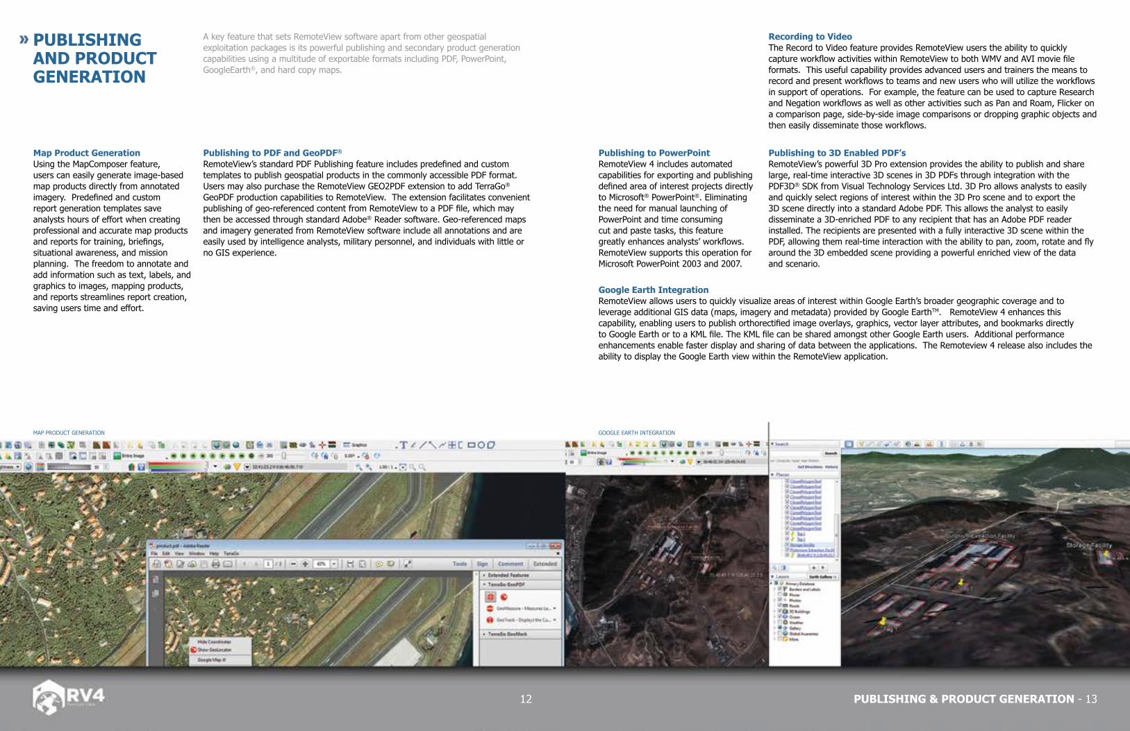
Map Product GenerationUsing the MapComposer feature, users can easily generate image-based map products directly from annotated imagery. Predefined and custom report generation templates save analysts hours of effort when creating professional and accurate map products and reports for training, briefings, situational awareness, and mission planning. The freedom to annotate and add information such as text, labels, and graphics to images, mapping products, and reports streamlines report creation, saving users time and effort.
Publishing to Pdf and GeoPdf® RemoteView’s standard PDF Publishing feature includes predefined and custom templates to publish geospatial products in the commonly accessible PDF format. Users may also purchase the RemoteView GEO2PDF extension to add TerraGo® GeoPDF production capabilities to RemoteView. The extension facilitates convenient publishing of geo-referenced content from RemoteView to a PDF file, which may then be accessed through standard Adobe® Reader software. Geo-referenced maps and imagery generated from RemoteView software include all annotations and are easily used by intelligence analysts, military personnel, and individuals with little or no GIS experience.
Publishing to 3d enabled Pdf’sRemoteView’s powerful 3D Pro extension provides the ability to publish and share large, real-time interactive 3D scenes in 3D PDFs through integration with the PDF3D® SDK from Visual Technology Services Ltd. 3D Pro allows analysts to easily and quickly select regions of interest within the 3D Pro scene and to export the 3D scene directly into a standard Adobe PDF. This allows the analyst to easily disseminate a 3D-enriched PDF to any recipient that has an Adobe PDF reader installed. The recipients are presented with a fully interactive 3D scene within the PDF, allowing them real-time interaction with the ability to pan, zoom, rotate and fly around the 3D embedded scene providing a powerful enriched view of the data and scenario.
recording to VideoThe Record to Video feature provides RemoteView users the ability to quickly capture workflow activities within RemoteView to both WMV and AVI movie file formats. This useful capability provides advanced users and trainers the means to record and present workflows to teams and new users who will utilize the workflows in support of operations. For example, the feature can be used to capture Research and Negation workflows as well as other activities such as Pan and Roam, Flicker on a comparison page, side-by-side image comparisons or dropping graphic objects and then easily disseminate those workflows.
Publishing to PowerPoint RemoteView 4 includes automated capabilities for exporting and publishing defined area of interest projects directly to Microsoft® PowerPoint®. Eliminating the need for manual launching of PowerPoint and time consuming cut and paste tasks, this feature greatly enhances analysts’ workflows. RemoteView supports this operation for Microsoft PowerPoint 2003 and 2007.
Google earth integrationRemoteView allows users to quickly visualize areas of interest within Google Earth’s broader geographic coverage and to leverage additional GIS data (maps, imagery and metadata) provided by Google EarthTM. RemoteView 4 enhances this capability, enabling users to publish orthorectified image overlays, graphics, vector layer attributes, and bookmarks directly to Google Earth or to a KML file. The KML file can be shared amongst other Google Earth users. Additional performance enhancements enable faster display and sharing of data between the applications. The Remoteview 4 release also includes the ability to display the Google Earth view within the RemoteView application.
PuBliShinG & ProduCt GenerAtion - 13
PuBliShinG And ProduCt GenerAtion
MAP PRODUCT GENERATION GOOGLE EARTH INTEGRATION
12
Interoperability and integration with a number of 3rd party applications and numerous GOTS products provide users expanded functionality within the RemoteView application. For example, RemoteView provides integration with:
3rd PArty inteGrAtion
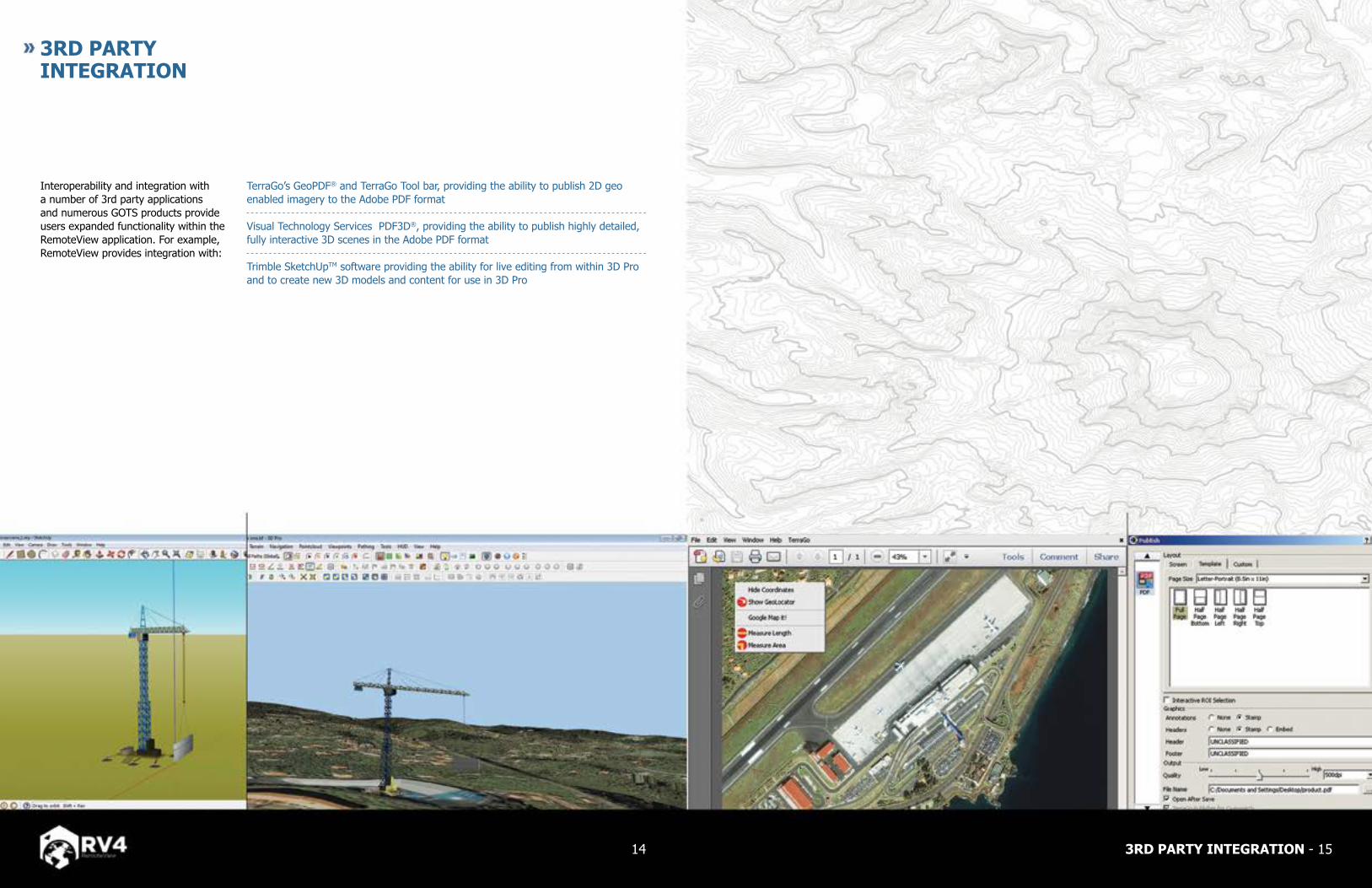
TerraGo’s GeoPDF® and TerraGo Tool bar, providing the ability to publish 2D geo enabled imagery to the Adobe PDF format
Visual Technology Services PDF3D®, providing the ability to publish highly detailed, fully interactive 3D scenes in the Adobe PDF format
Trimble SketchUpTM software providing the ability for live editing from within 3D Pro and to create new 3D models and content for use in 3D Pro
3rd PArty inteGrAtion - 1514
Optional extensions expand the power of the RemoteView product in a cost- effective, modular way, allowing customization to meet unique and specific user requirements without spending excessively on unneeded features and capabilities.6
ntM ModuleAccurate Precision Positioning Overwatch offers a restricted NTM Module that contains additional capabilities developed to serve the needs of the intelligence community. The RemoteView NTM Module provides integration with CGS providing the most advanced precision positioning capability available. The NTM Module is restricted to qualified customers only and is not available with the international version of RemoteView. The NTM Module is controlled on the USML and the export or re-export is subject to the U.S. International Traffic in Arms Regulations [22 CFR 120 - 130] and will require a license issued by the U.S. Department of State.
SoftWAreeXtenSionS
SoftWAre eXtenSionS - 17
The NTM Module is restricted only to qualified customers. Both the NTM Module and V-TRAC software extension are controlled on the USML and whose export or re-export is subject to the U.S. International Traffic in Arms Regulations (22 CFR 120-130) and will require a license issued by the U.S. Department of State.
VirtuAl MoSAiCEffortlessly Assemble Large-Scale Mosaics
The Virtual Mosaic extension streamlines the process of building extremely large-scale virtual mosaics from individual high-resolution images. Virtual Mosaic is ideal for broad area search applications or anytime a large area context is required for imagery analysis.
rVConneCt™Speed Efficiency and Collaboration
The RVConnect extension enables real-time interoperability between RemoteView and Esri’s widely used ArcGIS® software. Linking the two applications, RVConnect allows data, workflows and image layers to be synchronized and shared across both applications.
V-trAC™Master Full Motion Imagery Analysis
The V-TRAC extension provides analysts a complete motion imagery exploitation toolset within the RemoteView environment.
3d Pro™Visualize Missions in 3D
The 3D Pro extension dramatically expands RemoteView’s 3D visualization and analytical tools. 3D Pro provides the ability to visualize, fuse, analyze, and disseminate extremely large and diverse data sources into a visually compelling 3D view of the data allowing mission planners to make accurate decisions.
GeoCAtAloGTimely and Efficiently Manage All Your Geospatial Data
Available in desktop, workgroup and enterprise versions the GeoCatalog extension enables analysts with a one source tool for cataloging, querying, management and access to imagery, maps, and full motion video files across a variety of geospatial and legacy data sources.
Geo2Pdf Produce and Share GEO with Anyone, Anywhere
The GEO2PDF extension facilitates publishing of geo-referenced content from RemoteView to the widely used PDF document format, which may then be easily accessed through standard Adober Reader software using the free TerraGo Toolbar™. Geo-referenced PDF maps and imagery generated from RemoteView include all annotations and are easily used by intelligence analysts, military personnel, and individuals with little or no GIS experience.
6 Software extensions available for purchase and installation with RemoteView.
16
iMAGery AnAlySiS
Processes All national & Commercial imagery
over 30 image formats Supported• NITF, TFRD, GeoTIFF and more
Complete Work folder Architecture
image Quality and Visualization• Contrast, Brightness, MTFC Sharpening, and Haze controls• Magnify region of interest w/o obscuring original image• Dynamic Range Adjustment• Softcopy Image Processing Standard• Bicubic & Lagrange Resampling• Image histogram manipulation
Multi-Spectral and hyperspectral Processing• Multispectral Classification Wizard • Supervised classification• Import training sets from vector files• Unsupervised classification• Thresholding, Multiple-rules• Signature Editor• Statistics, Histograms• Image Calculator NDVI, TSI, Tasseled Cap• Edge Detection, Filtering, Sharpening, Smoothing• Pan-sharpening with auto-registration• Compose individual images into multi-spectral images
Multi-Band Analysis display (MAd)• Simultaneous display of up to sixteen band combinations• Synchronized/individual panning and histogram adjustment• Configurable band combinations, band formula, and layout• Templates for quick generation of MAD compositions
Photogrammetry• Geo data confidence indicator• Elevation coverage warning and display• Precision Positioning• Mensuration Tools• Orthorectification and Orthocalibration• Rigorous Orbview® and QuickBird sensor models• Community Sensor Model (CSM) interface• Image-to-Image calibration • Image-to-Vector calibration • Image-to-Reference calibration • On-the-fly epipolar resampling• Complete end-to-end processing and production tools • Position Quality Assessment (PQA) tool
Common Geo-Positioning Services (ntM Module)*• Intuitive Wizard for CGS, MSP and PinPoint• DPPDB Stand Alone (DSA) monoscopic positioning• NTM, Panchromatic and SAR, registered to DPPDB (NRD)• Two-to-four way Multi-Image Geopositioning (MIG)• DPPDB for height reference in Single Image Geopositioning• Height offset tools for measuring targets not on the ground• Automatic image location based on objective requirements• User customizable output integrated into same workflow• Automatic determination of missed point picks
rVPinPoint• Positioning tool with rigorous error propagation• Wizard-based source image collection• Works with unclassified commercial imagery
MASint (ntM Module)*• AGITK• AGP “Smart Loading”
Multi-iMAGe AnAlySiS
Change detection• Side-by-side comparison• Geographic and feature based alignment of images• Color multiview• Flicker• Colorized difference• Blend • Image Stacking & Coring• Review multiple images simultaneously• Auto Tie-Point Imagery Alignment
Stereo Viewing• Stereo pair shutter mode display• Synthesize and view anaglyph/pseudo stereo pair• Supports DPPDB data sets
Wide Area imagery • Virtual mosaic creation• Map Projected, processed Mosaics• Virtual Mosaic Editor• Supports unlimited images and 100+ GB mosaics • Virtual, ortho-mosaic, and map projection options• Drag-and-Drop mosaic building from RemoteView folder • Dynamic Range Control (Sharpen, Brightness, Contrast) • Auto or manual image alignment options• Dynamic mosaic cut lines • Rapid mosaic navigation• Create search patterns in Overview or Main Viewer windows• Apply pre-defined search patterns as Shapefiles• Overlay image data on mosaic option• Hide individual images or outlines• Create broad or directed area search patterns
GeoSPAtiAl AnAlySiS
GiS and Vector Sopport• GIS vector database and file formats• Spatial filtering • Metadata querying• Vector Layer Creation• Vector Import, Display, Creation and Editing • Display, edit, and create in Shapefile format• Vector query capabilities – spatial and attribute based• Vector cleaning tool – snap/clip to specified tolerance• Attribute table auto-populate tool• Polygon joining/splitting tools• Union, Intersect, XOR, Subtraction, Partition, Convex Hull
Mapping, Charting, Geodesy• OGC Support - Web Map Service (WMS) - Web Coverage Service (WCS)• Georeferencing • Scale bar & Multi-Scale bar• Map grids (Lat/Long, MGRS, UTM, etc.)• Orientation aids• Robust symbology pallet• North Arrow Design Tool • Datum conversions • Full set of USGS Map projections
ArcGiS interoperability• Real-time RemoteView/ArcGIS interoperability*• Sharing of vector layers and raster images*• Synchronized viewers and navigation*• Load/edit Esri Geodatabases directly into RemoteView*• Sharing of feature attribute modifications and changes*• Automated orthorectification of images to ArcGIS3D Pro** Enabled with RVConnect Extension
lidAr Point Clouds· View large LIDAR point cloud data sets· LIDAR derived elevation
tACtiCAl MiSSion PlAnninG
Motion imagery Analysis• Play motion imagery files leveraging intuitive player *• Tag motion imagery files for marking areas of interest*• Adjust motion imagery brightness and contrast in real-time*• Ability to zoom, adjust rotation, and pan through motion imagery*• Track motion imagery flight path over a 2D or 3D map or image*• Apply annotations to motion imagery frames within RemoteView*• Organize mission sets*• Capture live motion imagery streams**• Navigate live streams using forward, reverse, pause **• Tag, clip, and annotate frames in real-time**• Annotate with common shape graphic editor**• Generate reports using integrated Report Editor**• Automatically populate reports with metadata**• Export reports to PowerPoint or PDF***V-TRAC Basic Extension**V-TRAC Pro Extension
Grid reference Graphics (GrG)• Customizable grid labels• Macro and Micro views• Multiple grids
3d Visualization • Use LIDAR data as an elevation source• View terrain draped over elevation data in 3D• Elevation and volume calculation • Real-time, interactive 3D navigation• Ground path and flight path creation • Capture flight path as AVI video file• 2D Slope visualization tool• 2D Colorized elevation• 2D Field of View• Night vision scene simulation*• Filter and adjust LIDAR point cloud attributes*• Flight simulation with Heads-Up-Display*• Building Extrusions from Shapefiles*• 3D Threat Domes and Buffer Zones*• 3D View Shed/Line-of-Sight (LOS) Analysis*• 3D Text Annotations*• Supports industry standard 3D formats*• Displays 3D Geo-specific models*• Edit and import 3D models in Google SketchUp*• Create 3D walls*• Extended 3D model library with auto population tool*• 3D Interactive Measuring Tools*• 3D Interactive Landing Zone Tool*• Google Earth Support*• Save specific viewpoints for later review*• Capture the image to publish in reports and presentations*• Export image with all 3D data to 3D-enabled PDF** Enabled with 3D Pro Extension
Mobility and route Analysis• Slope field image computation • Visualize and mark areas of slope • Determine and map routes
landing zone Analysis• Aerial vehicle landing site identification• Elevation data inputs• Object radius inputs• Slope threshold inputs• 2D and 3D* landing zone drapes over imagery * Enabled with 3D Pro Extension
PuBliShinG & ProduCt GenerAtion
Annotations• Graphics and text annotation• Counting tool• Dimensioned graphics
Publishing tools• Map product generation• Templates for report generation• Hyperlinks to images, maps, and websites • Image chipping & coring• Record workflow activites to video files• SPIA Tag support and editor • Publish to PDF• Publish to GeoPDF (georeferenced imagery/annotations)• Publish to 3D PDF• Publish to PowerPoint• Publish to TIFF, JPEG, JPEG 2000, NITF, BMP, PNG, XML
Google earth integration and Publishing· Display and publish directly to Google Earth· Publish to KML/KMZ files shared amongst Google Earth users· Display Google Earth views in RemoteView application
AnAlySt WorKfloW enhAnCerS
data Cataloging and Management• Catalog imagery, maps, elevation, vector data, and motion imagery• Gain federated access to individual, shared, or enterprise level data• Supports both SQL Server® and Oracle® databases• Highly configurable and scalable to meet specific needs• Remove or add metadata to database schema and query results• Automatically generate reduced resolution data sets and thumbnails• Search diverse collections of geospatial data with a single query• Query geographical regions using bounding rectangles & point radius• Query by time, cloud cover, file type, or other metadata attributes• View, filter, sort, and hide results in Gallery display• Examine images in detail with Full Image Preview
roaming, Auto-review and Search• Broad Area Searching• Directed Area Searching• Geo-Jump location finding • Overview window
image Bookmarking• Saves display configurations• Exportable to XML, 3D Pro, Google Earth
Productivity Support• Individual and batch RSET generation• Individual file format conversion• Custom Folder Sorting
GeolinK Web data Collection and Publishing• Image Metadata browsing• Metadata driven searches of web datastore and web pages• Automated display of geocoded results• Web document generation
hardware Support• Image Metadata browsing• Multi-monitor Support• 64-Bit Processor Capable• Windows XP and 7 • Stereo Visualization
3rd Party integration• TerraGo’s GeoPDF® and TerraGo Tool bar • Visual Technology Services PDF3D® • Trimble SketchUp• Javascript® API Integration
*The NTM Module is restricted only to qualified customers. Both the NTM Module and V-TRAC software extension are controlled on the USML and whose export or re-export is subject to the U.S. International Traffic in Arms Regulations (22 CFR 120-130) and will require a license issued by the U.S. Department of State.
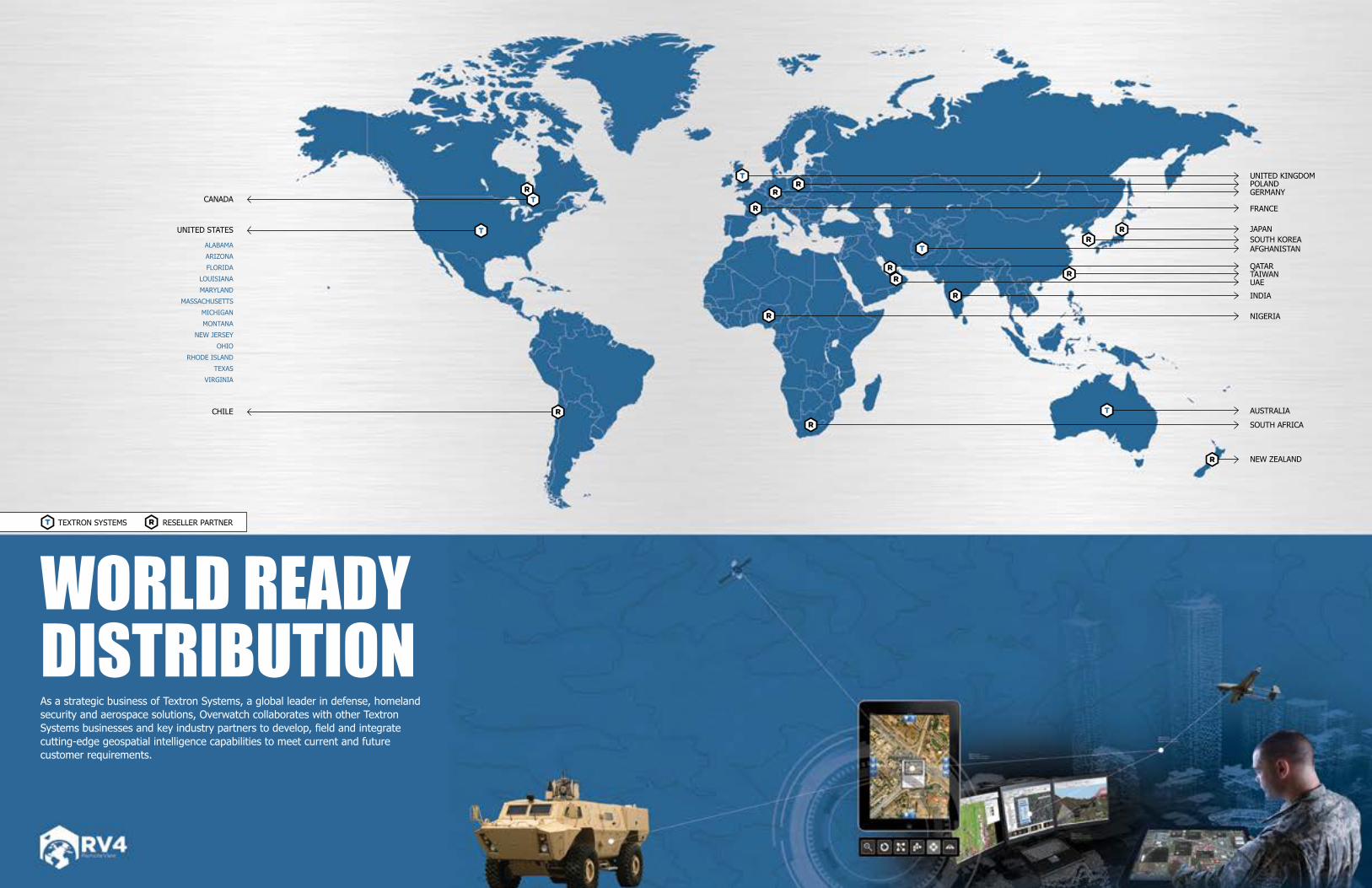
world readydistributionAs a strategic business of Textron Systems, a global leader in defense, homeland security and aerospace solutions, Overwatch collaborates with other Textron Systems businesses and key industry partners to develop, field and integrate cutting-edge geospatial intelligence capabilities to meet current and future customer requirements.
UNITED STATES
ALABAMA
ARIzONA
FLORIDA
LOUISIANA
MARyLAND
MASSACHUSETTS
MICHIGAN
MONTANA
NEW JERSEY
OHIO
RHODE ISLAND
TEXAS
VIRGINIA
TEXTRON SySTEMS RESELLER PARTNER
CANADA
CHILE
UNITED KINGDOMPOLANDGERMANy
FRANCE
JAPANSOUTH KOREAAFGHANISTAN
QATARTAIWANUAE
INDIA
NIGERIA
AUSTRALIA
SOUTH AFRICA
NEW zEALAND
overwatch 21660 Ridgetop Circle Suite 110 Sterling, VA 20166 (800) 937-6881
www.overwatch.com
© 2013 Overwatch Systems, Ltd. All rights reserved. Overwatch is an operating unit of Textron Systems, a Textron Inc. (NYSE: TXT) company. Overwatch, RemoteView, GeoCatalog, V-TRAC, RVConnect, Virtual Mosaic, and ImageStack are trademarks of Overwatch Systems, Ltd. Google Earth is trademark of Google, Inc. SketchUp is a trademark of Trimble Navigation. Windows, PowerPoint, and SQL Server are registered trademarks of Microsoft Corporation. Oracle and Javascript are registered trademarks of Oracle Corporation. TerraGo Toolbar is a trademark and GeoPDF is a registered trademark of TerraGo Technologies, Inc. ArcGIS is a registered trademark of Esri. Orbview is a registered trademark of GeoEye Imagery Collection Systems Inc. Adobe is a registered trademark of Adobe Systems Incorporated. Satellite imagery courtesy of GeoEye, DigitalGlobe, and Intermap. PDF3D is a registered trademark Visual Technology Services Ltd.