Embed Size (px)
Citation preview
Remote Sensing of Remote Sensing of Mesoscale Vortices in Mesoscale Vortices in Hurricane EyewallsHurricane Eyewalls
Presented by:Presented by:Chris CastellanoChris Castellano
Brian CerrutiBrian CerrutiStephen GarbarinoStephen Garbarino
AbstractAbstract
• A phenomena observed only by remote A phenomena observed only by remote sensing and new high resolution sensing and new high resolution technology technology
• Important to observe because they may Important to observe because they may play a significant role in the dynamics of play a significant role in the dynamics of the inner structures of hurricanesthe inner structures of hurricanes
• Without remote sensing instruments like Without remote sensing instruments like MODIS, AVHRR, and NEXRAD mesoscale MODIS, AVHRR, and NEXRAD mesoscale vortices would remain undetected. vortices would remain undetected.

OverviewOverview
• PlatformsPlatforms– TERRA/AQUATERRA/AQUA– NOAA 15,16,17NOAA 15,16,17– WSR-88D UnitsWSR-88D Units
• SensorsSensors– MODISMODIS– AVHRRAVHRR– NEXRAD NEXRAD
• ProductsProducts

PlatformsPlatforms
• TERRA/AQUATERRA/AQUA
• NOAA 15, 16, 17 NOAA 15, 16, 17
• WSR-88DWSR-88D

TERRA Satellite (EOS-AM1)TERRA Satellite (EOS-AM1)
• Multinational, multidiscipline missionMultinational, multidiscipline mission
• Managed by NASA with partners in Managed by NASA with partners in Canada and JapanCanada and Japan
• Planned 15 year data set to be Planned 15 year data set to be collected; began in February 2000collected; began in February 2000
• Sun SynchronousSun Synchronous

TERRA ContinuedTERRA Continued
• Descending time: Descending time: 10:30am10:30am
• Ascending time: Ascending time: 1:30pm1:30pm
• Dimensions: 5.99 x Dimensions: 5.99 x 1.7 x 2.0 meters1.7 x 2.0 meters
• Weight: 5190kgWeight: 5190kg• Power: 2530 W on Power: 2530 W on
averageaverage
MODISMOPITT
CERES MISR ASTER

AQUA Satellite (EOS-PM1)AQUA Satellite (EOS-PM1)
• Launched to collect data about the Launched to collect data about the earths water cycleearths water cycle
• Shares some of the same Shares some of the same instruments in its payload as TERRA instruments in its payload as TERRA satellite satellite
• First of the “Afternoon” Satellites First of the “Afternoon” Satellites
• Also uses a sun synchronous orbitAlso uses a sun synchronous orbit
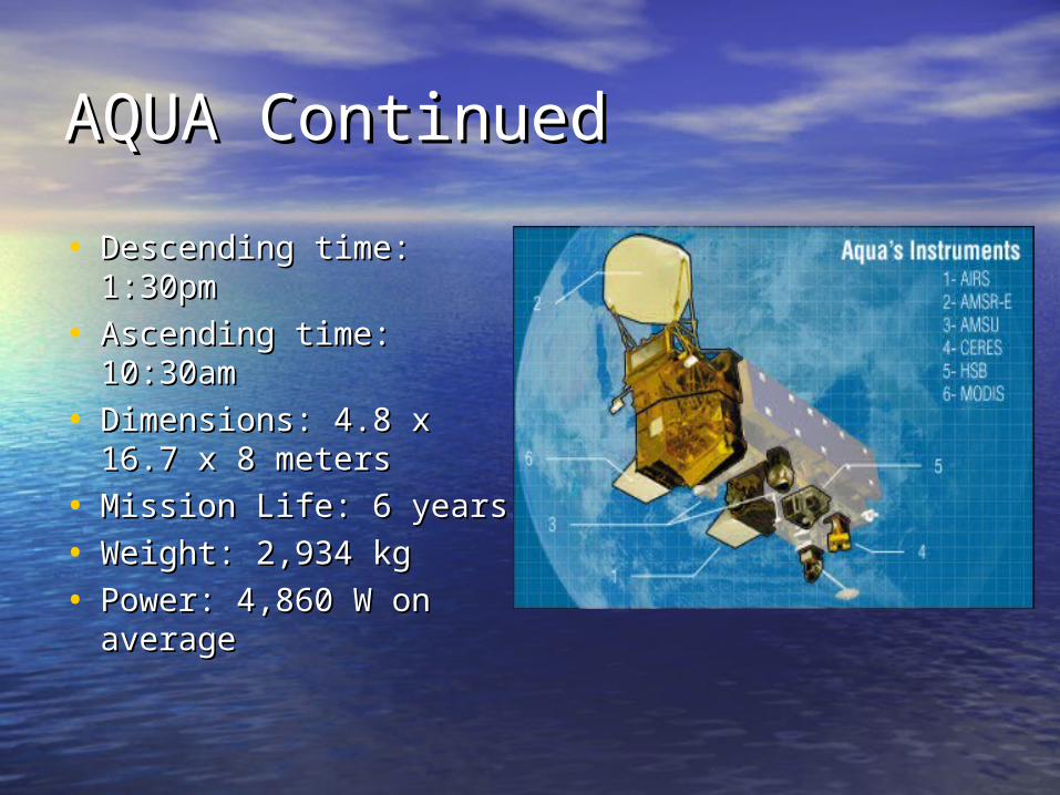
AQUA ContinuedAQUA Continued
• Descending time: Descending time: 1:30pm1:30pm
• Ascending time: Ascending time: 10:30am 10:30am
• Dimensions: 4.8 x Dimensions: 4.8 x 16.7 x 8 meters16.7 x 8 meters
• Mission Life: 6 yearsMission Life: 6 years
• Weight: 2,934 kgWeight: 2,934 kg
• Power: 4,860 W on Power: 4,860 W on averageaverage

NOAA 15NOAA 15
• Launched: May 1998Launched: May 1998
• Operational Status: AM secondaryOperational Status: AM secondary
• Altitude: 807 kmAltitude: 807 km
• Inclination: 98.5 degreesInclination: 98.5 degrees
• Period: 100.1 minutesPeriod: 100.1 minutes
• Carries a variety of instruments Carries a variety of instruments including AVHRRincluding AVHRR

NOAA 16NOAA 16
• Launched: September 2000Launched: September 2000
• Operational Status: PM secondaryOperational Status: PM secondary
• Altitude: 849 kmAltitude: 849 km
• Inclination: 99 degreesInclination: 99 degrees
• Period: 102.1 minutesPeriod: 102.1 minutes
• All instruments on NOAA 15 plus one All instruments on NOAA 15 plus one additional instrumentadditional instrument

NOAA 17NOAA 17
• Launched: June 2002Launched: June 2002
• Operational Status: AM backupOperational Status: AM backup
• Altitude: 810 kmAltitude: 810 km
• Inclination: 98.7 degreesInclination: 98.7 degrees
• Period: 101.2 minutesPeriod: 101.2 minutes
• All instruments on NOAA 16All instruments on NOAA 16

NOAA 15 NOAA 15 Before Before LaunchLaunch
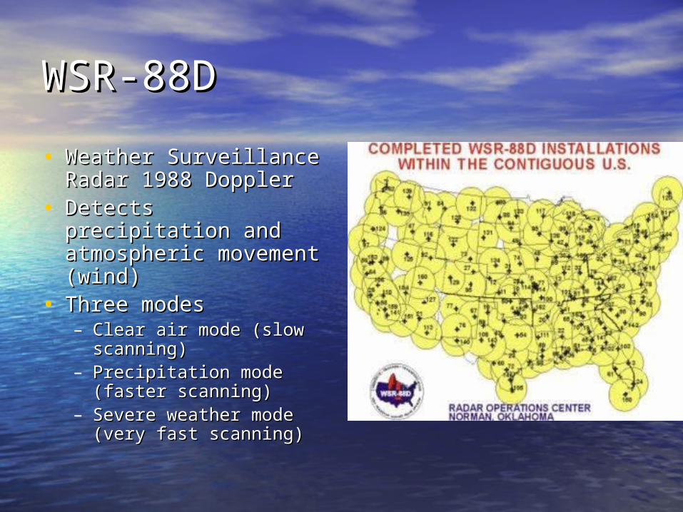
WSR-88D WSR-88D
• Weather Surveillance Weather Surveillance Radar 1988 DopplerRadar 1988 Doppler
• Detects precipitation Detects precipitation and atmospheric and atmospheric movement (wind)movement (wind)
• Three modesThree modes– Clear air mode (slow Clear air mode (slow
scanning)scanning)– Precipitation mode Precipitation mode
(faster scanning)(faster scanning)– Severe weather mode Severe weather mode
(very fast scanning)(very fast scanning)

SensorsSensors
• MODISMODIS– TERRA and AQUA SatellitesTERRA and AQUA Satellites
• AVHRRAVHRR– NOAA 15, 16, 17 SatellitesNOAA 15, 16, 17 Satellites
• NEXRAD NEXRAD – WSR-88D UnitsWSR-88D Units

MODISMODIS
• Moderate Resolution Imaging Moderate Resolution Imaging Spectroradiometer Spectroradiometer
• On board both the Terra (am) and On board both the Terra (am) and Aqua (pm) satellitesAqua (pm) satellites
• Provides high resolution radiometric Provides high resolution radiometric sensitivitysensitivity
• Global coverage every 1-2 daysGlobal coverage every 1-2 days

MODIS continuedMODIS continued
• Range: 0.4um to 14.4umRange: 0.4um to 14.4um• 36 spectral bands36 spectral bands
– 2 have Nadir Resolution: 250 m2 have Nadir Resolution: 250 m– 5 have 500 m resolution5 have 500 m resolution– Rest have 1km resolutionRest have 1km resolution
• +- 5 degrees scanning pattern+- 5 degrees scanning pattern• Altitude: 705 kmAltitude: 705 km• Achieves 2,330 km swathAchieves 2,330 km swath

MODIS continuedMODIS continued
• Uses a whiskbroom scanning method to Uses a whiskbroom scanning method to collect datacollect data
• The optical system uses a two mirror off-The optical system uses a two mirror off-axis a-focal telescopeaxis a-focal telescope– Directs energy to 4 refractive objective Directs energy to 4 refractive objective
assemblies assemblies – One for each One for each
• VisVis• NIRNIR• SW/MW IRSW/MW IR• LW IRLW IR

MODIS continuedMODIS continued
• Uses a photodiode-Uses a photodiode-silicon technology silicon technology for visible and NIR for visible and NIR to reduce noiseto reduce noise
• Has 4 on board Has 4 on board calibrators as well calibrators as well as a view to space as a view to space to keep the to keep the measurements measurements accurateaccurate

MODIS ImageryMODIS Imagery
• Hurricane IsabelHurricane Isabel
• Visible bandVisible band
• 13 September 13 September 20032003

MODIS ImageryMODIS Imagery
• Hurricane KatrinaHurricane Katrina
• Terra SatelliteTerra Satellite
• 28 August 200528 August 2005

MODIS ImageryMODIS Imagery
• Hurricane WilmaHurricane Wilma
• 21 October 200521 October 2005

AVHRRAVHRR
• Advance very high resolution radiometerAdvance very high resolution radiometer
• Used to remotely determine cloud cover Used to remotely determine cloud cover and “surface temperature”and “surface temperature”
• Whiskbroom scannerWhiskbroom scanner
• At 833km the IFOV 1.1 x 1.1km at nadirAt 833km the IFOV 1.1 x 1.1km at nadir
• 4 site revisitations per day4 site revisitations per day
• 6 different channels6 different channels

AVHRR continuedAVHRR continued
AVHRR Channel Characteristics
Channel Number Resolution at
Nadir Wavelengt
h (um) Typical Use
1 1.09 km 0.58 - 0.68 Daytime cloud and
surface mapping
2 1.09 km 0.725 -
1.00 Land-water boundaries
3A 1.09 km 1.58 - 1.64 Snow and ice detection
3B 1.09 km 3.55 - 3.93 Night cloud mapping, sea
surface temperature
4 1.09 km 10.30 -
11.30 Night cloud mapping, sea
surface temperature
5 1.09 km 11.50 -
12.50 Sea surface temperature

AVHRR ImageryAVHRR Imagery
• Hurricane KatrinaHurricane Katrina
• NOAA-15NOAA-15
• 28 August 200528 August 2005

AVHRR ImageryAVHRR Imagery
• Hurricane IsabelHurricane Isabel
• NOAA-15NOAA-15
• 15 September 15 September 20032003

AVHRR ImageryAVHRR Imagery
• Hurricane DeanHurricane Dean
• NOAA-16NOAA-16
• 20 August 200720 August 2007

NEXRADNEXRAD
• Determines location and intensity of Determines location and intensity of precipitation, wind speed to/from the precipitation, wind speed to/from the radar site, as well as several other radar site, as well as several other products (VIL, storm tracks, etc.)products (VIL, storm tracks, etc.)
• 16 tilts (data levels ) are available16 tilts (data levels ) are available
• .6 x .6 miles resolution out to 143 .6 x .6 miles resolution out to 143 miles for base reflectivity at 0.5 miles for base reflectivity at 0.5 degrees (tilt 1)degrees (tilt 1)

NEXRAD continuedNEXRAD continued
• Clear air modeClear air mode– 5 elevation angles5 elevation angles
• Precipitation modePrecipitation mode– 9 elevation angles9 elevation angles
• Severe weather modeSevere weather mode– 14 elevation angles14 elevation angles– Sub-mode of precipitation mode, not Sub-mode of precipitation mode, not
regularly delineated from itregularly delineated from it

NEXRAD continuedNEXRAD continued
• How does radar work?How does radar work?– Creates EM pulse focused by an antenna Creates EM pulse focused by an antenna
transmitted through the atmospheretransmitted through the atmosphere– Objects within range scatter and reflect Objects within range scatter and reflect
the energy the energy – Energy returning to the radar is called an Energy returning to the radar is called an
echoecho– Large target = stronger echo (hail)Large target = stronger echo (hail)– Many targets = stronger echo (heavy Many targets = stronger echo (heavy
precip)precip)

NEXRAD continuedNEXRAD continued

NEXRAD continuedNEXRAD continued

NEXRAD continuedNEXRAD continued
• What is important for our use?What is important for our use?– Base Radial VelocityBase Radial Velocity
•Measurement of movement of particles Measurement of movement of particles to/from radarto/from radar
– Storm Relative Radial Velocity Storm Relative Radial Velocity •4 tilts, storm motion is subtracted from the 4 tilts, storm motion is subtracted from the
base radial velocitybase radial velocity

NEXRAD ImageryNEXRAD Imagery

NEXRANEXRAD D ImagerImageryy

SummarySummary
• PlatformsPlatforms– TERRA/AQUATERRA/AQUA– NOAA 15,16,17NOAA 15,16,17– WSR-88D UnitsWSR-88D Units
• SensorsSensors– MODISMODIS– AVHRRAVHRR– NEXRAD NEXRAD
• ProductsProducts

Questions?Questions?
…sometimes you don't need a …sometimes you don't need a satellite…satellite…
International Space Station
Sept 13, 2003