Embed Size (px)
DESCRIPTION
ground water recharge by GIS
Citation preview
“Remote Sensing and GIS approaches in Artificial Recharge of the Ground
Water Potential Zones in PT-7 Watershed of Akola District
Maharashtra”ByDr. S.F.R. Khadri & Kanak N.
Moharir
Department of Geology Sant Gadge Baba Amravati University
Amravati 9th January 2014
1. Remote sensing and GIS are playing a rapidly increasing role in the field of hydrology and water resources development. Remote sensing provides multi-spectral, multi-temporal and multi-sensor data of the earth’s surface (Choudhury, 1999).
2. The GIS technology provides suitable alternatives for efficient management of large and complex databases. Information from satellites is becoming more and more important for environmental research.
INTRODUCTION
Idiosyncrasy of monsoon and diverse physiographic conditions give rise to unequal distribution of water.
3. The study focuses on development of remote sensing and GIS based analysis and methodology in groundwater recharge studies in watershed. In order to demonstrate the Role of remote sensing
and GIS based methodology, the sub-watershed of PT-7 of Akola district state of Maharashtra (India) has been taken for analyzed.
Study Area
The present study area is sub watershed of Purna river lies between 20°51'0"N and 21°14'30"N latitude and between 76°46'0"E and 77°3'0"E longitude covering parts of Akola district of Maharashtra. The basin area is demarcated from the survey of India Topographical maps were used, it covers an area about 564.55sq.km (Fig. 1). The sub watershed area is represented by the survey of India Topographical maps; 55D/13, and 55C/16 was used.
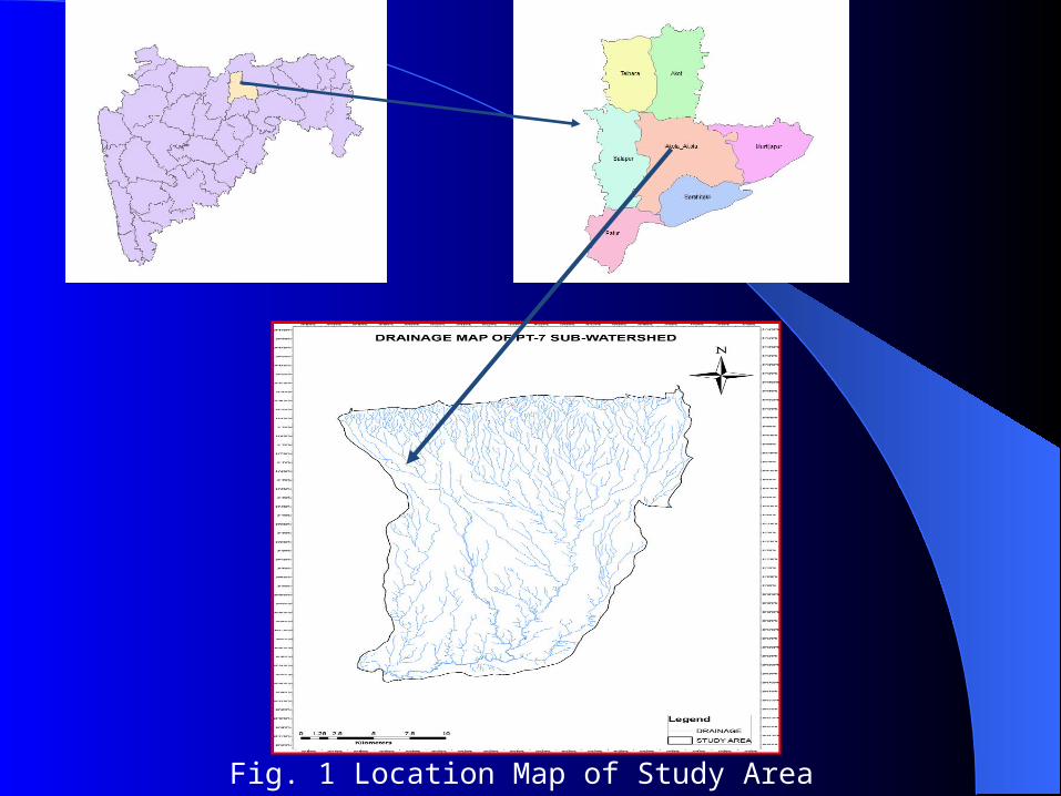
Fig. 1 Location Map of Study Area
Aims and objectives1. To use of remote sensing and GIS
technique in groundwater recharge investigations in sub watershed.
2. To prepare the groundwater potential zones in the sub watershed.
3. To identify the interrelationships of recharge areas with geology, geomorphology, soils and structure of the sub watershed.
4. To suggest suitable sites and methods for artificial recharge to augment groundwater recharge with Village Tank, cement nala bund etc. In the sub watershed.
Methodology
The methodology adopted in the present study is presented schematically and described in the following steps:
1. The LISS-III Open Source satellite image was used for linear, aerial for drainage basin analysis and interpretation (Fig.2). The image interpretation characteristics such as tone, texture, shape, size, pattern and association along with sufficient ground truth and local knowledge were used to finalize the maps of the PT-7 watershed area.
2. The slope map is generated using SRTM data
and spatial analyst tool used from Arc Map software 10.00. The Survey of India toposheets of scale 1: 50,000 are used for delineating the watershed boundary, drainage pattern for the preparation of base map and extracting different thematic layers for the various part of analysis namely drainage, road and water bodies etc.
3. Geomorphology map is prepared using visual interpretation technique and interpretation keys such as tone, texture, size, shape, pattern, shadow and association.
Physiographic 1. The study area can be broadly divided into
low lying plain towards the banks of the PT-7 Sub-watershed in the northeast and horizontal Deccan Trap flows with multiple scarps and abrupt cliffs towards the southern parts.
2. The study area consists of various erosional surfaces in step-like terraces. The horizontal dispositions of the lava flows with a fair degree of uniformity in lithology have considerably simplified the changes brought by the secondary processes like weathering and denudation. (Fig.2) .

Fig. 2 The 3D Model View of PT-7 Watershed
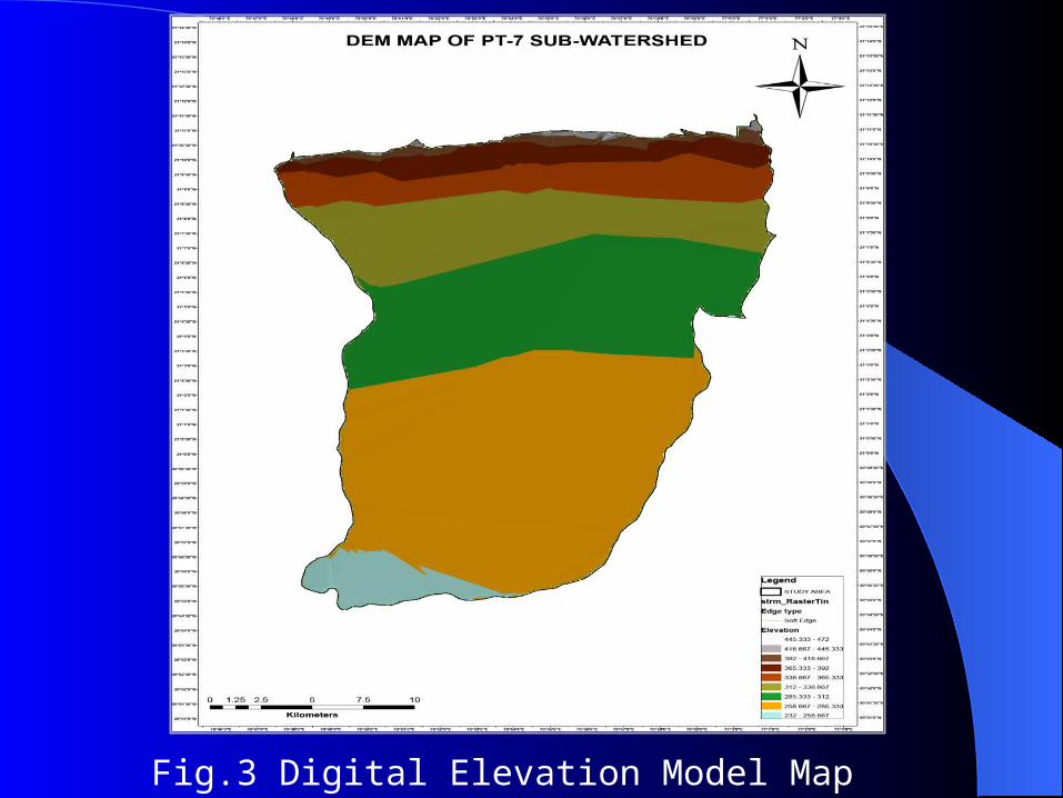
Fig.3 Digital Elevation Model Map
Geomorphology In other words, geomorphology is the study
of landforms and landscapes, including the description, classification, origin development and history of planetary surfaces.
The geomorphological map of the PT-7 sub-watershed has prepared by visual interpretation of the LISS-III satellite image and visual interpretation is carried out base on the image characteristics like tone, size, shape, pattern, texture, location, associated background etc. in conjunction with existing maps and literature.
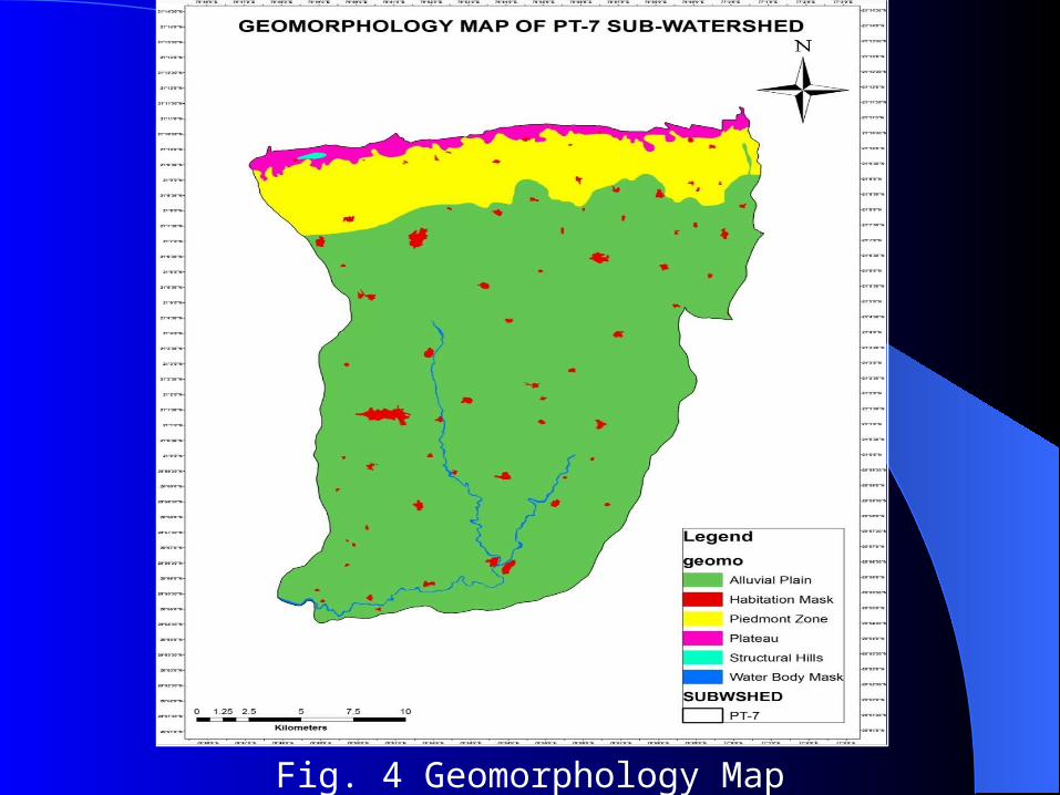
Fig. 4 Geomorphology Map
Soil Characteristics of the watershed
1. The soil information for the study area was digitized from the soil map.
Generally, seven (7) types of soil had been identified in the study area.
2. The soil types of study area are clayey soil, clay loam, clayey, gravely clay, gravely clay loam, gravely sandy loam, sandy clay, and gravely sandy clay. Which are show in the following Fig. 5.
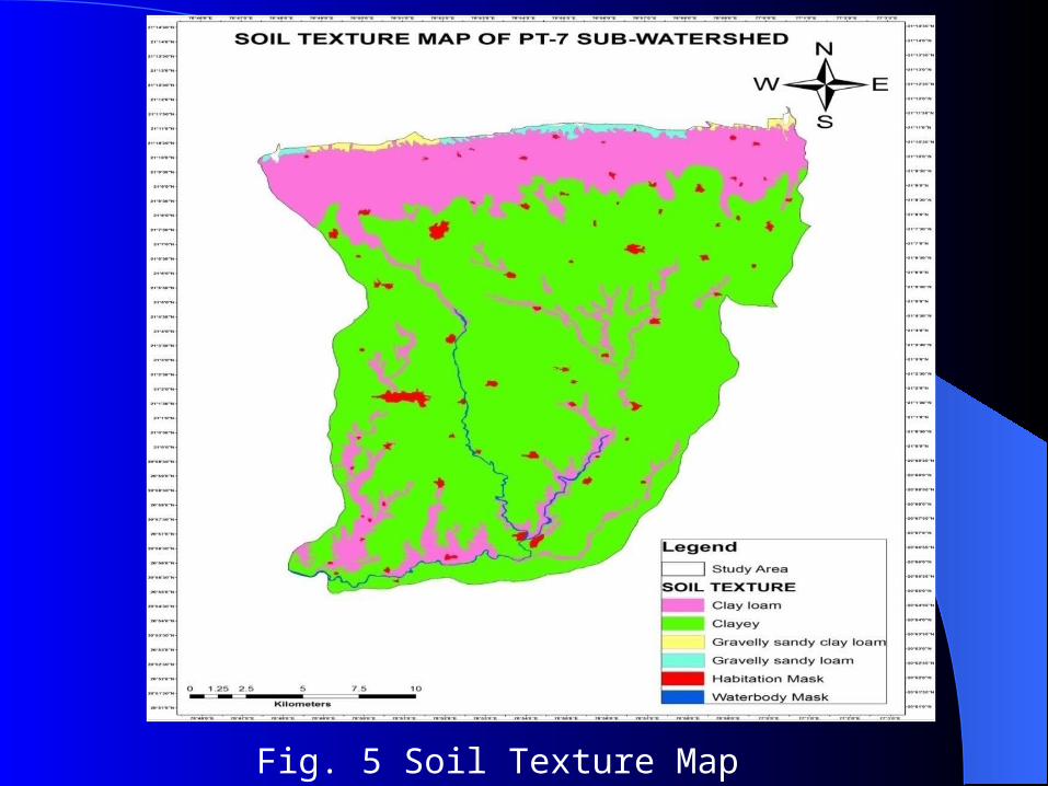
Fig. 5 Soil Texture Map
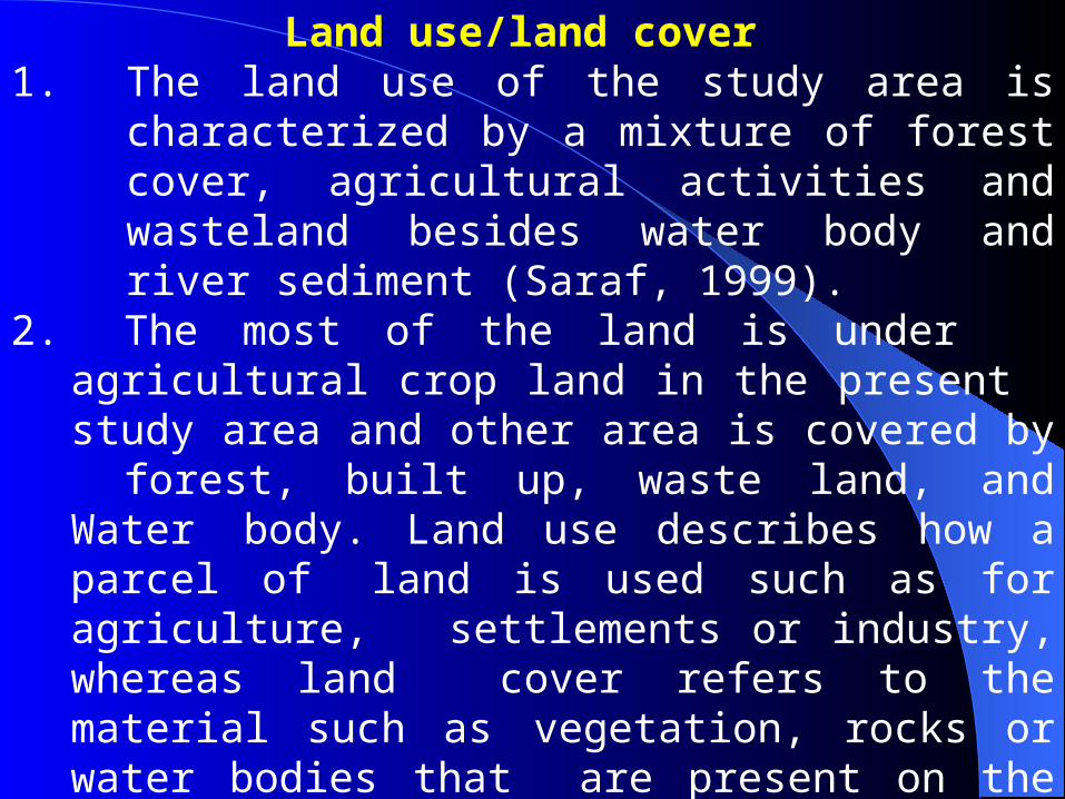
Land use/land cover 1. The land use of the study area is
characterized by a mixture of forest cover, agricultural activities and wasteland besides water body and river sediment (Saraf, 1999).
2. The most of the land is under agricultural crop land in the present study area and other area is covered by forest, built up, waste land, and Water body. Land use describes how a parcel of land is used such as for agriculture, settlements or industry, whereas land cover refers to the material such as vegetation, rocks or water bodies that are present on the earth surface.
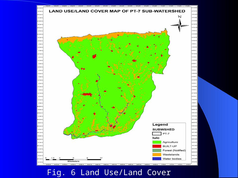
Fig. 6 Land Use/Land Cover Map
Artificial recharge site selection1. Artificial recharge is the process of
augmenting the natural movement of surface water into underground formations by some artificial methods. This is accomplished by constructing infiltration facilities or by inducing recharge from surface water bodies. In hard rock areas, the underlying lithological units do not have sufficient porosity and permeability.
2. The performance of these efforts can be immensely increased if they are performed through proper scientific planning.
Integrated remote sensing and GIS can be a very powerful tool for planning of suitability for artificial recharge structures.
3. In this present study has successfully demonstrated an integrated remote sensing and GIS technique to suggest suitable area for future artificial recharge structures in the PT-7
watershed. The site selection is purely based on hydro geological point of view, the engineering aspects are not considered here (Fig.7).
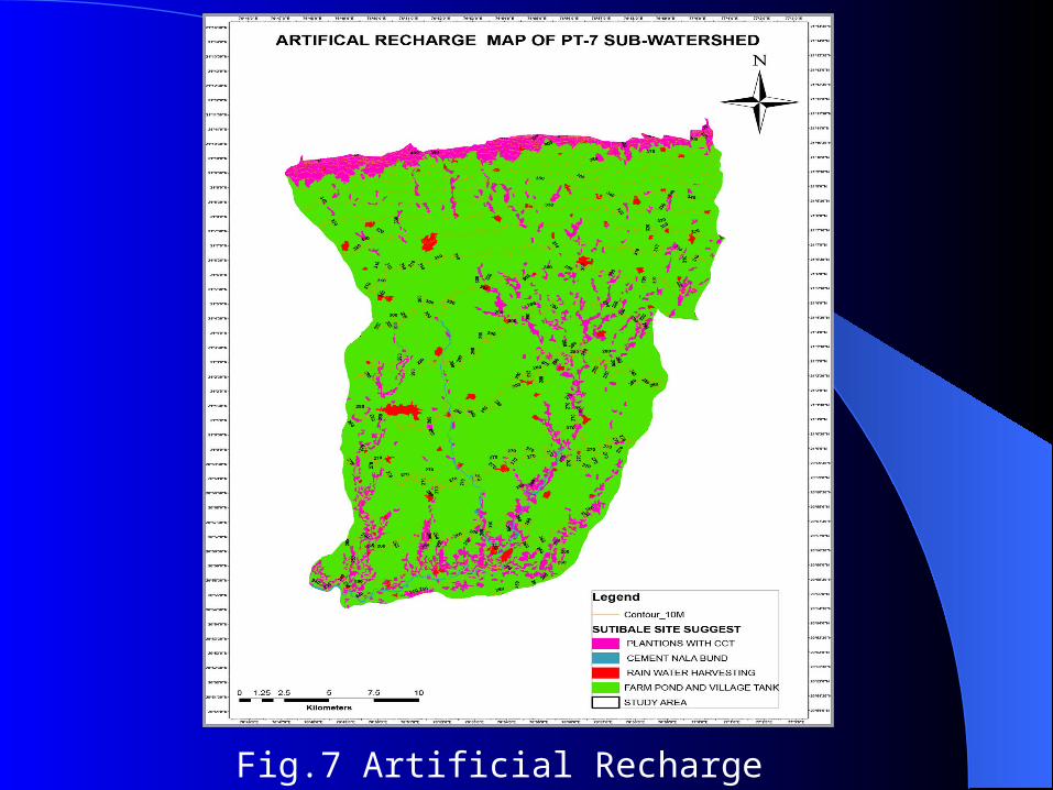
Fig.7 Artificial Recharge Map
Groundwater Resource Assessment
1. In the present study, the groundwater level map and ground water potential map is used for the quantitative estimate of groundwater recharge in the PT-7 watershed.
2. The Role of Remote Sensing and GIS in Artificial Recharge of the Ground Water Aquifer in the PT-7 Sub Watershed in the Purna River Basin, Akola District, Maharashtra.
3. There are various methods in use for the quantitative evaluation of groundwaterrecharge e.g. (a) groundwater level
map(b) rainfall infiltration method. In the present study, the groundwater level map and ground water potential map is used for the quantitative estimate of groundwater recharge in the PT-7 watershed.
4. Groundwater movement is controlled by natural boundaries watershed is the most appropriate unit for groundwater recharge estimation through constructs
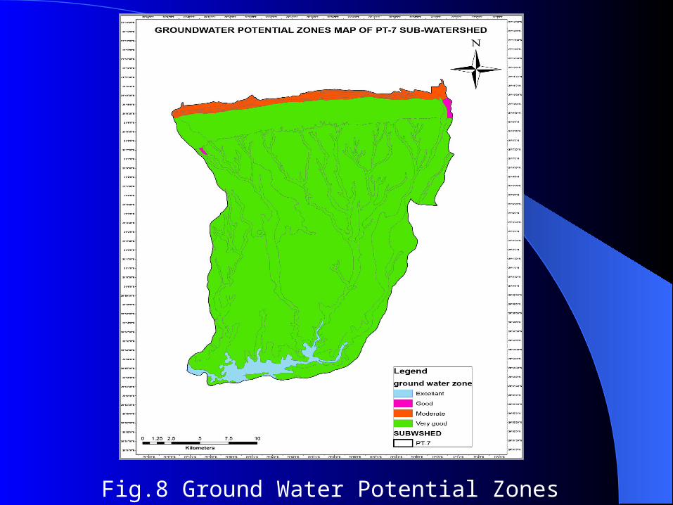
Fig.8 Ground Water Potential Zones Map
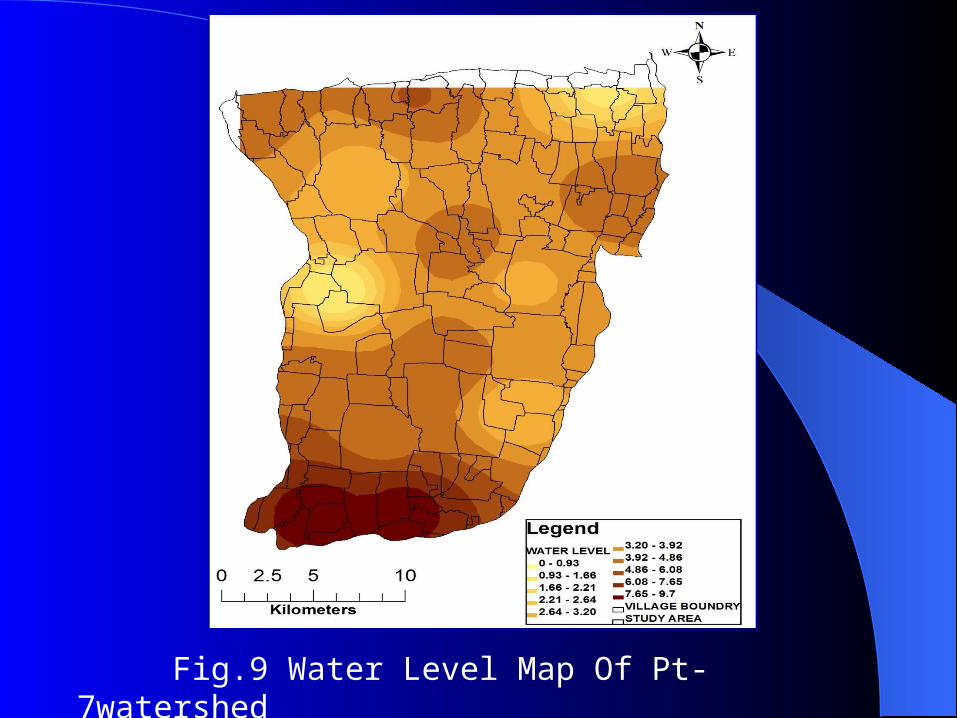
Fig.9 Water Level Map Of Pt-7watershed
Conclusions
The following conclusions are drawn from the above study:
1. In the present study a Role of remote sensing and GIS based methodology has been developed and demonstrated for evaluation of groundwater resources.
2. The present study has demonstrated that the recharge sites situated on a gentle slope and lower order streams are likely to provide artificial recharge to a larger area.
3. Combination of geology, land use land cover, geomorphology, contour, soil and digital elevation model has been found very useful in the selection of suitable sites for artificial recharge.
4. Change in land use is mainly due to the hydrological factors as is clear from the change image derived by subtraction of the land use maps.
5. Moderately high-resolution satellite images data (LISS-III) provide details of the terrain, as well as a synoptic overview, to visualize the general groundwater condition indirectly.

Thank You