Embed Size (px)
Citation preview
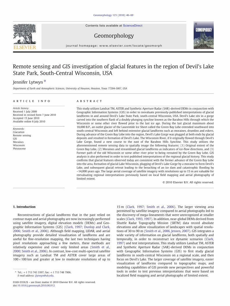
Geomorphology 123 (2010) 46–60
Contents lists available at ScienceDirect
Geomorphology
j ourna l homepage: www.e lsev ie r.com/ locate /geomorph
Remote sensing and GIS investigation of glacial features in the region of Devil's LakeState Park, South-Central Wisconsin, USA
Jennifer Lytwyn ⁎Department of Earth and Atmospheric Sciences, University of Houston, Houston, Texas 77204-5007, USA
⁎ Tel.: +1 713 743 3397; fax: +1 713 748 7906.E-mail address: [email protected].
0169-555X/$ – see front matter © 2010 Elsevier B.V. Adoi:10.1016/j.geomorph.2010.06.012
a b s t r a c t
a r t i c l e i n f oArticle history:Received 1 July 2009Received in revised form 7 June 2010Accepted 15 June 2010Available online 8 July 2010
Keywords:GlaciationRemote sensingGISMorainesWisconsinPleistocene
This study utilizes Landsat TM, ASTER and Synthetic Aperture Radar (SAR)-derived DEMs in conjunction withGeographic Information Systems (GIS) in order to reevaluate previously-published interpretations of glaciallandforms in and around Devil's Lake State Park, south-central Wisconsin, USA. Devil's Lake sits in a gorgecarved into the southern flank of a doubly-plunging syncline known as the Baraboo Hills through which theWisconsin or some other river flowed prior to the last ice age. During the last glacial maximum about18,000 B.P., an outlet glacier of the Laurentide Ice Sheet called the Green Bay Lobe extended southward intosouth-central Wisconsin and left behind extensive glacial landforms such as moraines, drumlins and eskers.During advance of the Green Bay Lobe into the region, Devil's Lake Gorge was plugged at both ends by glacialdeposits and resulted in formation of Devil's Lake. The Wisconsin River, if it originally flowed through Devil'sLake Gorge, found a new course to the east of the Baraboo Hills Syncline. This study utilizes theaforementioned remote sensing data to spatially image the following features: (1) Original extent of theGreen Bay Lobe, (2) Moraines and streamlined glacial landforms as indicators of ice-flow directions, and (3)Former path of the old Wisconsin or some other river prior to being rerouted by the Green Bay Lobe. GISanalysis is also performed in order to test published interpretations of the regional glacial history. This studyconfirms that glacial features observed today are consistent with the former advance of the Green Bay Lobeinto the area, formation of glacial Lake Wisconsin, plugging of Devil's Lake Gorge by a moraine to form Devil'sLake, and subsequent glacial retreat leading to the breaching of an ice dam and catastrophic flooding by~14,000 years ago. The large aerial coverage of satellite imagery with resolutions up to 15 m are valuable forreevaluating regional interpretations previously based on local field mapping and aerial photography oflimited extent.
ll rights reserved.
© 2010 Elsevier B.V. All rights reserved.
1. Introduction
Reconstructions of glacial landforms that in the past relied oncontourmaps and aerial photography are now increasingly performedusing satellite imagery, digital elevation models (DEMs) and Geo-graphic Information Systems (GIS) (Clark, 1997; Dunlop and Clark,2006; Smith et al., 2006). Although field mapping, LIDAR, and aerialphotography provide detailed visualization of landforms and areuseful for fine-resolution mapping, the last two techniques havingpixel resolutions approaching a few meters, these methods arerelatively expensive and cover only limited areas (Smith et al.,2000; Smith et al., 2006). In contrast, low-cost multi-spectral satelliteimagery such as Landsat TM and ASTER cover large areas of100×100 km and greater at low to moderate resolutions of up to
15 m (Clark, 1997; Smith et al., 2006). The larger viewing areapermitted by satellite imagery compared to aerial photographs led tothe discovery of mega-lineaments that were unrecognized at smallerscales (Clark, 1993, 1997). In addition, near-global DEMs derived fromShuttle Radar Topography Mission (SRTM) data record absoluteelevations and allow visualization of landscapes with spatial resolu-tions of 30 to 90 m (Smith et al., 2006, Jensen, 2007). GIS integrates awide variety of information on glacial landforms, both spatially andtemporally, in order to reconstruct ice dynamic scenarios (Clark,1997) and test interpretations. This study utilizes Landsat TM, ASTERand Synthetic Aperture Radar (SAR)-derived DEMs in conjunctionwith Geographic Information Systems (GIS) to first study glaciallandforms in south-central Wisconsin on a regional scale, and thenfocus on Devil's Lake. The larger coverage of satellite imagery, easiervisualization of landforms compared to topographic maps, andmodeling capabilities of GIS provide new perspectives and powerfultools in order to test previous interpretations that were based onlocalized field mapping and aerial photographs of limited extent.
47J. Lytwyn / Geomorphology 123 (2010) 46–60
2. Regional geology
2.1. Older rocks
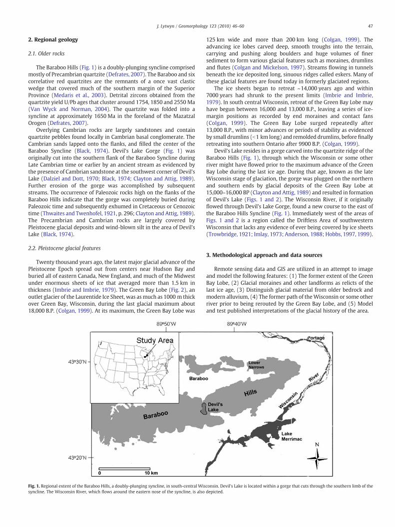
The Baraboo Hills (Fig. 1) is a doubly-plunging syncline comprisedmostly of Precambrian quartzite (Defrates, 2007). The Baraboo and sixcorrelative red quartzites are the remnants of a once vast clasticwedge that covered much of the southern margin of the SuperiorProvince (Medaris et al., 2003). Detrital zircons obtained from thequartzite yield U/Pb ages that cluster around 1754, 1850 and 2550 Ma(Van Wyck and Norman, 2004). The quartzite was folded into asyncline at approximately 1650 Ma in the foreland of the MazatzalOrogen (Defrates, 2007).
Overlying Cambrian rocks are largely sandstones and containquartzite pebbles found locally in Cambrian basal conglomerate. TheCambrian sands lapped onto the flanks, and filled the center of theBaraboo Syncline (Black, 1974). Devil's Lake Gorge (Fig. 1) wasoriginally cut into the southern flank of the Baraboo Syncline duringLate Cambrian time or earlier by an ancient stream as evidenced bythe presence of Cambrian sandstone at the southwest corner of Devil'sLake (Dalziel and Dott, 1970; Black, 1974; Clayton and Attig, 1989).Further erosion of the gorge was accomplished by subsequentstreams. The occurrence of Paleozoic rocks high on the flanks of theBaraboo Hills indicate that the gorge was completely buried duringPaleozoic time and subsequently exhumed in Cretaceous or Cenozoictime (Thwaites and Twenhofel, 1921, p. 296; Clayton and Attig, 1989).The Precambrian and Cambrian rocks are largely covered byPleistocene glacial deposits and wind-blown silt in the area of Devil'sLake (Black, 1974).
2.2. Pleistocene glacial features
Twenty thousand years ago, the latest major glacial advance of thePleistocene Epoch spread out from centers near Hudson Bay andburied all of eastern Canada, New England, and much of the Midwestunder enormous sheets of ice that averaged more than 1.5 km inthickness (Imbrie and Imbrie, 1979). The Green Bay Lobe (Fig. 2), anoutlet glacier of the Laurentide Ice Sheet, was asmuch as 1000 m thickover Green Bay, Wisconsin, during the last glacial maximum about18,000 B.P. (Colgan, 1999). At its maximum, the Green Bay Lobe was
Fig. 1. Regional extent of the Baraboo Hills, a doubly-plunging syncline, in south-central Wissyncline. The Wisconsin River, which flows around the eastern nose of the syncline, is also
125 km wide and more than 200 km long (Colgan, 1999). Theadvancing ice lobes carved deep, smooth troughs into the terrain,carrying and pushing along boulders and huge volumes of finersediment to form various glacial features such as moraines, drumlinsand flutes (Colgan and Mickelson, 1997). Streams flowing in tunnelsbeneath the ice deposited long, sinuous ridges called eskers. Many ofthese glacial features are found today in formerly glaciated regions.
The ice sheets began to retreat ~14,000 years ago and within7000 years had shrunk to the present limits (Imbrie and Imbrie,1979). In south central Wisconsin, retreat of the Green Bay Lobe mayhave begun between 16,000 and 13,000 B.P., leaving a series of ice-margin positions as recorded by end moraines and contact fans(Colgan, 1999). The Green Bay Lobe surged repeatedly after13,000 B.P., with minor advances or periods of stability as evidencedby small drumlins (b1 km long) and remolded drumlins, before finallyretreating into southern Ontario after 9900 B.P. (Colgan, 1999).
Devil's Lake resides in a gorge carved into the quartzite ridge of theBaraboo Hills (Fig. 1), through which the Wisconsin or some otherriver might have flowed prior to the maximum advance of the GreenBay Lobe during the last ice age. During that age, known as the lateWisconsin stage of glaciation, the gorge was plugged on the northernand southern ends by glacial deposits of the Green Bay Lobe at15,000–16,000 BP (Clayton and Attig, 1989) and resulted in formationof Devil's Lake (Figs. 1 and 2). The Wisconsin River, if it originallyflowed through Devil's Lake Gorge, found a new course to the east ofthe Baraboo Hills Syncline (Fig. 1). Immediately west of the areas ofFigs. 1 and 2 is a region called the Driftless Area of southwesternWisconsin that lacks any evidence of ever being covered by ice sheets(Trowbridge, 1921; Imlay, 1973; Anderson, 1988; Hobbs, 1997, 1999).
3. Methodological approach and data sources
Remote sensing data and GIS are utilized in an attempt to imageand model the following features: (1) The former extent of the GreenBay Lobe, (2) Glacial moraines and other landforms as relicts of thelast ice age, (3) Distinguish glacial material from older bedrock andmodern alluvium, (4) The former path of theWisconsin or some otherriver prior to being rerouted by the Green Bay Lobe, and (5) Modeland test published interpretations of the glacial history of the area.
consin. Devil's Lake is located within a gorge that cuts through the southern limb of thedepicted.
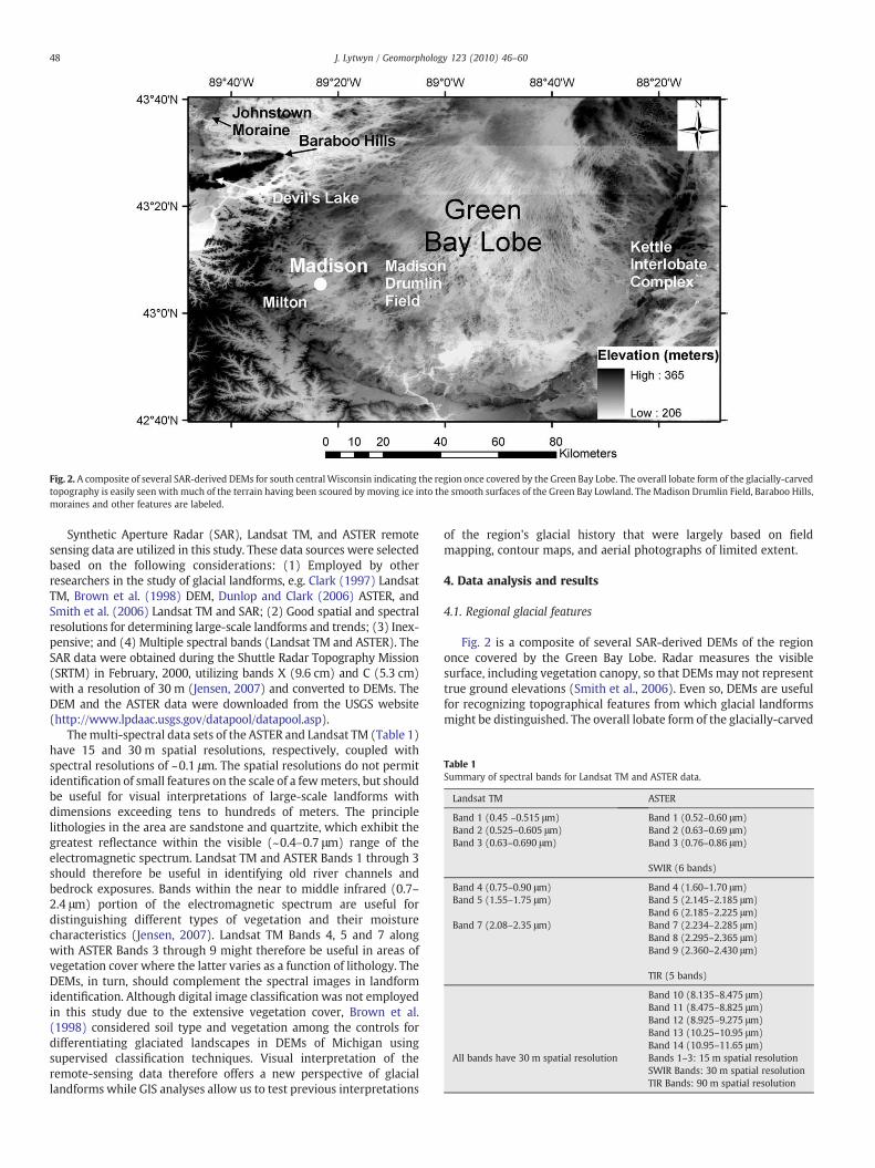
Fig. 2. A composite of several SAR-derived DEMs for south centralWisconsin indicating the region once covered by the Green Bay Lobe. The overall lobate form of the glacially-carvedtopography is easily seen with much of the terrain having been scoured by moving ice into the smooth surfaces of the Green Bay Lowland. The Madison Drumlin Field, Baraboo Hills,moraines and other features are labeled.
Table 1Summary of spectral bands for Landsat TM and ASTER data.
Landsat TM ASTER
Band 1 (0.45 –0.515 μm) Band 1 (0.52–0.60 μm)Band 2 (0.525–0.605 μm) Band 2 (0.63–0.69 μm)Band 3 (0.63–0.690 μm) Band 3 (0.76–0.86 μm)
SWIR (6 bands)
Band 4 (0.75–0.90 μm) Band 4 (1.60–1.70 μm)Band 5 (1.55–1.75 μm) Band 5 (2.145–2.185 μm)
Band 6 (2.185–2.225 μm)Band 7 (2.08–2.35 μm) Band 7 (2.234–2.285 μm)
Band 8 (2.295–2.365 μm)Band 9 (2.360–2.430 μm)
TIR (5 bands)
Band 10 (8.135–8.475 μm)Band 11 (8.475–8.825 μm)Band 12 (8.925–9.275 μm)Band 13 (10.25–10.95 μm)Band 14 (10.95–11.65 μm)
All bands have 30 m spatial resolution Bands 1–3: 15 m spatial resolutionSWIR Bands: 30 m spatial resolutionTIR Bands: 90 m spatial resolution
48 J. Lytwyn / Geomorphology 123 (2010) 46–60
Synthetic Aperture Radar (SAR), Landsat TM, and ASTER remotesensing data are utilized in this study. These data sources were selectedbased on the following considerations: (1) Employed by otherresearchers in the study of glacial landforms, e.g. Clark (1997) LandsatTM, Brown et al. (1998) DEM, Dunlop and Clark (2006) ASTER, andSmith et al. (2006) Landsat TM and SAR; (2) Good spatial and spectralresolutions for determining large-scale landforms and trends; (3) Inex-pensive; and (4) Multiple spectral bands (Landsat TM and ASTER). TheSAR data were obtained during the Shuttle Radar Topography Mission(SRTM) in February, 2000, utilizing bands X (9.6 cm) and C (5.3 cm)with a resolution of 30 m (Jensen, 2007) and converted to DEMs. TheDEM and the ASTER data were downloaded from the USGS website(http://www.lpdaac.usgs.gov/datapool/datapool.asp).
Themulti-spectral data sets of the ASTER and Landsat TM (Table 1)have 15 and 30 m spatial resolutions, respectively, coupled withspectral resolutions of ~0.1 μm. The spatial resolutions do not permitidentification of small features on the scale of a fewmeters, but shouldbe useful for visual interpretations of large-scale landforms withdimensions exceeding tens to hundreds of meters. The principlelithologies in the area are sandstone and quartzite, which exhibit thegreatest reflectance within the visible (~0.4–0.7 μm) range of theelectromagnetic spectrum. Landsat TM and ASTER Bands 1 through 3should therefore be useful in identifying old river channels andbedrock exposures. Bands within the near to middle infrared (0.7–2.4 μm) portion of the electromagnetic spectrum are useful fordistinguishing different types of vegetation and their moisturecharacteristics (Jensen, 2007). Landsat TM Bands 4, 5 and 7 alongwith ASTER Bands 3 through 9 might therefore be useful in areas ofvegetation cover where the latter varies as a function of lithology. TheDEMs, in turn, should complement the spectral images in landformidentification. Although digital image classification was not employedin this study due to the extensive vegetation cover, Brown et al.(1998) considered soil type and vegetation among the controls fordifferentiating glaciated landscapes in DEMs of Michigan usingsupervised classification techniques. Visual interpretation of theremote-sensing data therefore offers a new perspective of glaciallandforms while GIS analyses allow us to test previous interpretations
of the region's glacial history that were largely based on fieldmapping, contour maps, and aerial photographs of limited extent.
4. Data analysis and results
4.1. Regional glacial features
Fig. 2 is a composite of several SAR-derived DEMs of the regiononce covered by the Green Bay Lobe. Radar measures the visiblesurface, including vegetation canopy, so that DEMs may not representtrue ground elevations (Smith et al., 2006). Even so, DEMs are usefulfor recognizing topographical features from which glacial landformsmight be distinguished. The overall lobate form of the glacially-carved
49J. Lytwyn / Geomorphology 123 (2010) 46–60
topography is easily seen with much of the terrain having beenscoured by moving ice into the smooth surfaces of the Green BayLowland. The rim of the large-scale, lobate structure is bordered byextensive ridges consisting of moraines and associated glaciofluvialsediment that was transported and piled up along the margins of theadvancing ice sheet, or deposited by glacial meltwater. The JohnstownMoraine in the upper left hand corner of Fig. 2 marks the maximumextent of the Green Bay Lobe in the area and abuts against the BarabooHills synclinal structure. Other arcuate ridges inboard of the Johns-town Moraine include the Milton Moraine and associated glacio-fluvial sediment that formed during retreat of the Green Bay Lobefollowing the Johnstown Phase (Colgan and Mickelson, 1997). Theeastern margin of the Green Bay Lowland is defined by the KettleInterlobate Complex. The Kettle Moraine is composed of ice-contactand glaciofluvial sediment that is bounded by an escarpment ofSilurian dolomite, forming the boundary between the Green Bay Lobeand Lake Michigan Lobe to the east (Colgan and Mickelson, 1997;Colgan, 1999).
4.2. Madison drumlin field
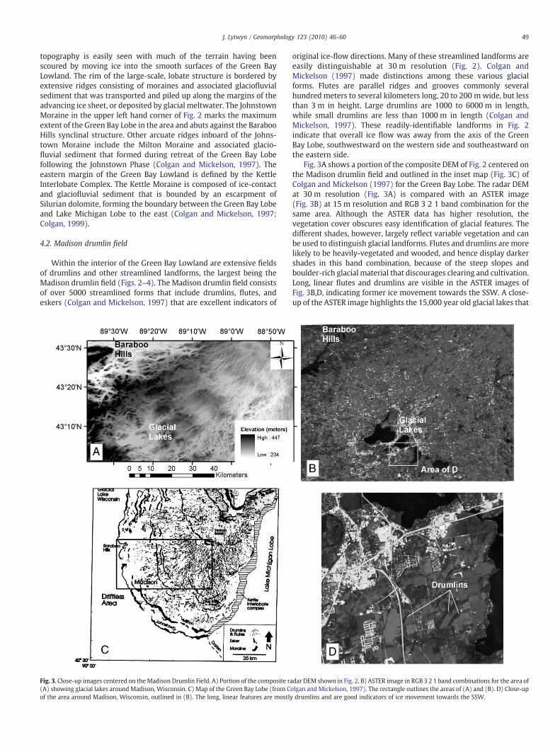
Within the interior of the Green Bay Lowland are extensive fieldsof drumlins and other streamlined landforms, the largest being theMadison drumlin field (Figs. 2–4). The Madison drumlin field consistsof over 5000 streamlined forms that include drumlins, flutes, andeskers (Colgan and Mickelson, 1997) that are excellent indicators of
Fig. 3. Close-up images centered on theMadison Drumlin Field. A) Portion of the composite ra(A) showing glacial lakes aroundMadison, Wisconsin. C) Map of the Green Bay Lobe (from Cof the area around Madison, Wisconsin, outlined in (B). The long, linear features are mostly
original ice-flow directions. Many of these streamlined landforms areeasily distinguishable at 30 m resolution (Fig. 2). Colgan andMickelson (1997) made distinctions among these various glacialforms. Flutes are parallel ridges and grooves commonly severalhundred meters to several kilometers long, 20 to 200 mwide, but lessthan 3 m in height. Large drumlins are 1000 to 6000 m in length,while small drumlins are less than 1000 m in length (Colgan andMickelson, 1997). These readily-identifiable landforms in Fig. 2indicate that overall ice flow was away from the axis of the GreenBay Lobe, southwestward on the western side and southeastward onthe eastern side.
Fig. 3A shows a portion of the composite DEM of Fig. 2 centered onthe Madison drumlin field and outlined in the inset map (Fig. 3C) ofColgan and Mickelson (1997) for the Green Bay Lobe. The radar DEMat 30 m resolution (Fig. 3A) is compared with an ASTER image(Fig. 3B) at 15 m resolution and RGB 3 2 1 band combination for thesame area. Although the ASTER data has higher resolution, thevegetation cover obscures easy identification of glacial features. Thedifferent shades, however, largely reflect variable vegetation and canbe used to distinguish glacial landforms. Flutes and drumlins are morelikely to be heavily-vegetated and wooded, and hence display darkershades in this band combination, because of the steep slopes andboulder-rich glacial material that discourages clearing and cultivation.Long, linear flutes and drumlins are visible in the ASTER images ofFig. 3B,D, indicating former ice movement towards the SSW. A close-up of the ASTER image highlights the 15,000 year old glacial lakes that
dar DEM shown in Fig. 2. B) ASTER image in RGB 3 2 1 band combinations for the area ofolgan and Mickelson, 1997). The rectangle outlines the areas of (A) and (B). D) Close-updrumlins and are good indicators of ice movement towards the SSW.
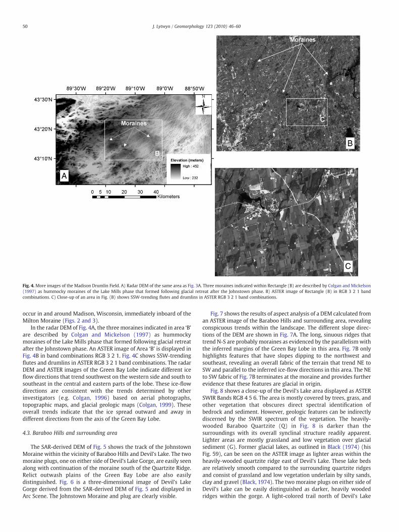
Fig. 4. More images of the Madison Drumlin Field. A) Radar DEM of the same area as Fig. 3A. Three moraines indicated within Rectangle (B) are described by Colgan and Mickelson(1997) as hummocky moraines of the Lake Mills phase that formed following glacial retreat after the Johnstown phase. B) ASTER image of Rectangle (B) in RGB 3 2 1 bandcombinations. C) Close-up of an area in Fig. (B) shows SSW-trending flutes and drumlins in ASTER RGB 3 2 1 band combinations.
50 J. Lytwyn / Geomorphology 123 (2010) 46–60
occur in and around Madison, Wisconsin, immediately inboard of theMilton Moraine (Figs. 2 and 3).
In the radar DEM of Fig. 4A, the threemoraines indicated in area ‘B’are described by Colgan and Mickelson (1997) as hummockymoraines of the Lake Mills phase that formed following glacial retreatafter the Johnstown phase. An ASTER image of Area ‘B’ is displayed inFig. 4B in band combinations RGB 3 2 1. Fig. 4C shows SSW-trendingflutes and drumlins in ASTER RGB 3 2 1 band combinations. The radarDEM and ASTER images of the Green Bay Lobe indicate different iceflow directions that trend southwest on the western side and south tosoutheast in the central and eastern parts of the lobe. These ice-flowdirections are consistent with the trends determined by otherinvestigators (e.g. Colgan, 1996) based on aerial photographs,topographic maps, and glacial geologic maps (Colgan, 1999). Theseoverall trends indicate that the ice spread outward and away indifferent directions from the axis of the Green Bay Lobe.
4.3. Baraboo Hills and surrounding area
The SAR-derived DEM of Fig. 5 shows the track of the JohnstownMoraine within the vicinity of Baraboo Hills and Devil's Lake. The twomoraine plugs, one on either side of Devil's Lake Gorge, are easily seenalong with continuation of the moraine south of the Quartzite Ridge.Relict outwash plains of the Green Bay Lobe are also easilydistinguished. Fig. 6 is a three-dimensional image of Devil's LakeGorge derived from the SAR-derived DEM of Fig. 5 and displayed inArc Scene. The Johnstown Moraine and plug are clearly visible.
Fig. 7 shows the results of aspect analysis of a DEM calculated froman ASTER image of the Baraboo Hills and surrounding area, revealingconspicuous trends within the landscape. The different slope direc-tions of the DEM are shown in Fig. 7A. The long, sinuous ridges thattrend N-S are probably moraines as evidenced by the parallelism withthe inferred margins of the Green Bay Lobe in this area. Fig. 7B onlyhighlights features that have slopes dipping to the northwest andsoutheast, revealing an overall fabric of the terrain that trend NE toSW and parallel to the inferred ice-flow directions in this area. The NEto SW fabric of Fig. 7B terminates at the moraine and provides furtherevidence that these features are glacial in origin.
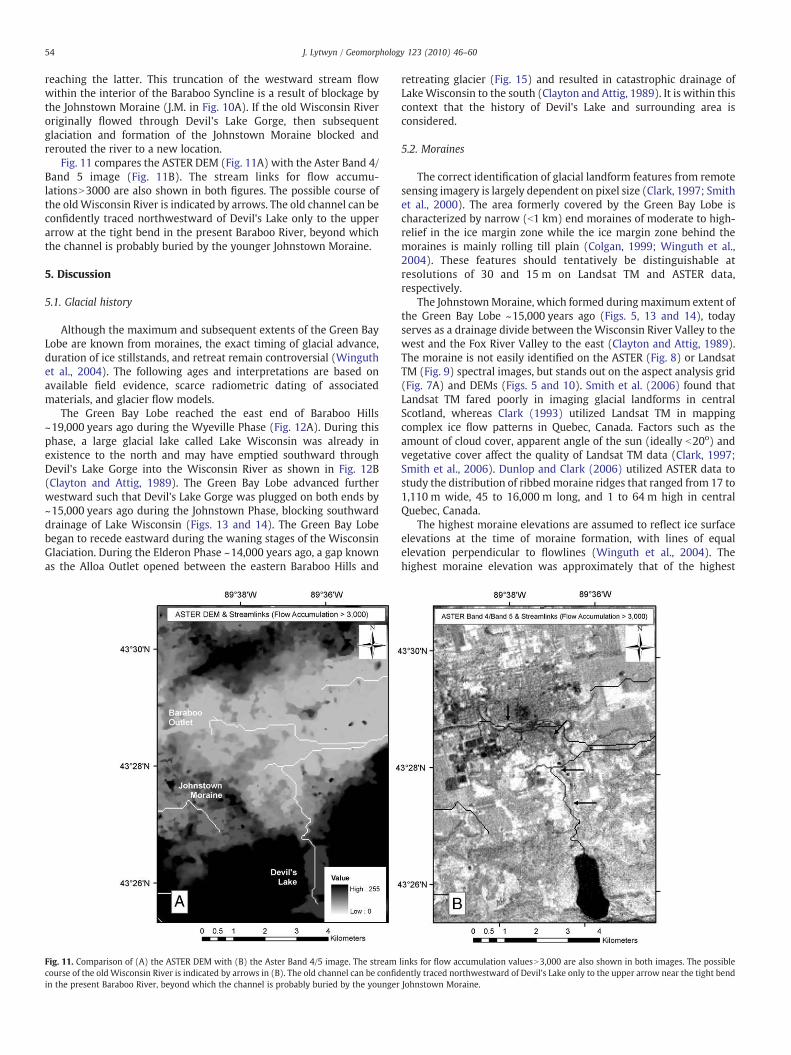
Fig. 8 shows a close-up of the Devil's Lake area displayed as ASTERSWIR Bands RGB 4 5 6. The area is mostly covered by trees, grass, andother vegetation that obscures direct spectral identification ofbedrock and sediment. However, geologic features can be indirectlydiscerned by the SWIR spectrum of the vegetation. The heavily-wooded Baraboo Quartzite (Q) in Fig. 8 is darker than thesurroundings with its overall synclinal structure readily apparent.Lighter areas are mostly grassland and low vegetation over glacialsediment (G). Former glacial lakes, as outlined in Black (1974) (hisFig. 59), can be seen on the ASTER image as lighter areas within theheavily-wooded quartzite ridge east of Devil's Lake. These lake bedsare relatively smooth compared to the surrounding quartzite ridgesand consist of grassland and low vegetation underlain by silty sands,clay and gravel (Black, 1974). The two moraine plugs on either side ofDevil's Lake can be easily distinguished as darker, heavily woodedridges within the gorge. A light-colored trail north of Devil's Lake
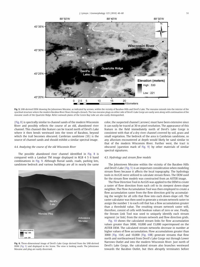
Fig. 5. SAR-derived DEM showing the Johnstown Moraine, as indicated by arrows, within the vicinity of Baraboo Hills and Devil's Lake. The moraine extends into the interior of thesynclinal structure where themodern Baraboo River flows through a breach. The twomoraine plugs on either side of Devil's Lake Gorge are easily seen along with continuation of themoraine south of the Quartzite Ridge. Relict outwash plains of the Green Bay Lobe are also easily distinguished.
51J. Lytwyn / Geomorphology 123 (2010) 46–60
(Fig. 8) is spectrally similar to channel sands of the modernWisconsinRiver and possibly reflects the course of an old, abandoned riverchannel. This channel-like feature can be traced north of Devil's Lakewhere it then bends westward into the town of Baraboo, beyondwhich the trail becomes obscured. Cambrian sandstone (SS) is thesource of channel sands and should exhibit a similar spectral image.
4.4. Analyzing the course of the old Wisconsin River
The possible abandoned river channel identified in Fig. 8 iscompared with a Landsat TM image displayed in RGB 4 5 6 bandcombinations in Fig. 9. Although fluvial sands, roads, parking lots,sandstone bedrock and various buildings are all in nearly the same
Fig. 6. Three-dimensional image of Devil's Lake Gorge derived from the SAR-derivedDEM (Fig. 5) and displayed in Arc Scene. The view is looking south. The JohnstownMoraine and plug are easily discerned.
color, the suspected channel (arrows)must have been extensive sinceit can easily be traced at 30 m pixel resolution. The appearance of thisfeature in the field immediately north of Devil's Lake Gorge isconsistent with that of a dry river channel covered by soil, grass andsmall vegetation. The bedrock of the area is Cambrian sandstone, soany alluvium encountered at depth would likely be sand similar tothat of the modern Wisconsin River. Further west, the tract isobscured (question mark of Fig. 9) by other materials of similarspectral signatures.
4.5. Hydrology and stream flow models
The Johnstown Moraine within the vicinity of the Baraboo Hillsand Devil's Lake (Fig. 5) is an important consideration whenmodelingstream flows because it affects the local topography. The hydrologytools in ArcGIS were utilized to calculate stream flows. The DEM usedfor the stream flow models was constructed from an ASTER image.
The Flow Direction Tool in ArcGIS was applied to the DEM to createa raster of flow direction from each cell to its steepest down-slopeneighbor. The Flow Accumulation Tool was then employed to create aflow accumulation raster from the flow direction grid by accumulat-ing the weight for all cells that flow into each down-slope cell. Theraster calculator was then used to generate a stream network raster toassign the number 1 to each cell that has a flow accumulation greaterthan a threshold value. The resulting stream network raster will,therefore, consist of cells with boolean values of zero or one. Finally,the Stream Link Tool was used to uniquely identify each streamsegment (or link) from the stream network and flow direction grids.
Fig. 10 shows the calculated stream links for flow accumulationvalues greater than 3000, 10,000 and 15,000 superimposed on theASTER DEM. The calculated stream networks decrease in number athigher values of flow accumulation. Flow accumulations greater than3000 (Fig. 10A) and 10,000 (Fig. 10B) generate streams that flownorth and northeastward from Devil's Lake Gorge out through LowerNarrows Outlet and into the modern Wisconsin River. Just north ofDevil's Lake Gorge, the calculated stream also branches westwardtowards the Baraboo Outlet, but then abruptly terminates before
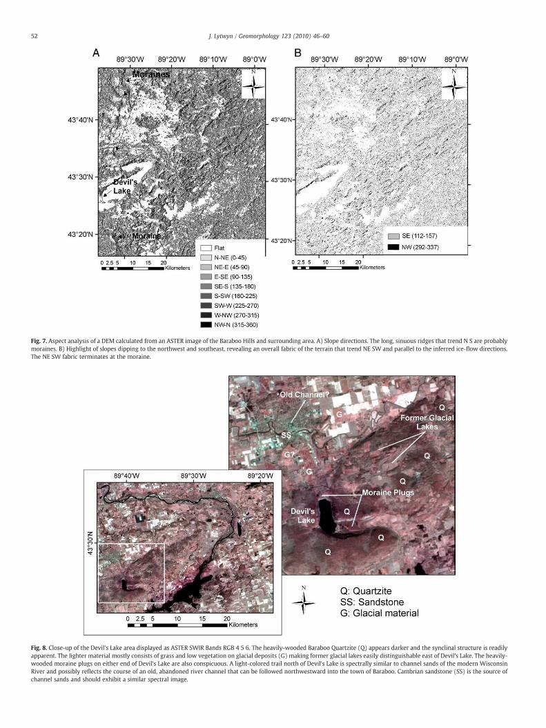
Fig. 7. Aspect analysis of a DEM calculated from an ASTER image of the Baraboo Hills and surrounding area. A) Slope directions. The long, sinuous ridges that trend N S are probablymoraines. B) Highlight of slopes dipping to the northwest and southeast, revealing an overall fabric of the terrain that trend NE SW and parallel to the inferred ice-flow directions.The NE SW fabric terminates at the moraine.
Fig. 8. Close-up of the Devil's Lake area displayed as ASTER SWIR Bands RGB 4 5 6. The heavily-wooded Baraboo Quartzite (Q) appears darker and the synclinal structure is readilyapparent. The lighter material mostly consists of grass and low vegetation on glacial deposits (G) making former glacial lakes easily distinguishable east of Devil's Lake. The heavily-wooded moraine plugs on either end of Devil's Lake are also conspicuous. A light-colored trail north of Devil's Lake is spectrally similar to channel sands of the modern WisconsinRiver and possibly reflects the course of an old, abandoned river channel that can be followed northwestward into the town of Baraboo. Cambrian sandstone (SS) is the source ofchannel sands and should exhibit a similar spectral image.
52 J. Lytwyn / Geomorphology 123 (2010) 46–60
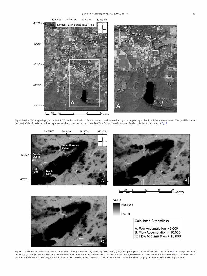
Fig. 9. Landsat TM image displayed in RGB 4 5 6 band combinations. Fluvial deposits, such as sand and gravel, appear aqua blue in this band combination. The possible course(arrows) of the old Wisconsin River appears as a band that can be traced north of Devil's Lake into the town of Baraboo, similar to the trend in Fig. 8.
Fig. 10. Calculated stream links for flow accumulation values greater than (A) 3000, (B) 10,000 and (C) 15,000 superimposed on the ASTER DEM. See Section 4.5 for an explanation ofthe values. (A) and (B) generate streams that flow north and northeastward from the Devil's Lake Gorge out through the Lower Narrows Outlet and into themodernWisconsin River.Just north of the Devil's Lake Gorge, the calculated stream also branches westward towards the Baraboo Outlet, but then abruptly terminates before reaching the latter.
53J. Lytwyn / Geomorphology 123 (2010) 46–60
54 J. Lytwyn / Geomorphology 123 (2010) 46–60
reaching the latter. This truncation of the westward stream flowwithin the interior of the Baraboo Syncline is a result of blockage bythe Johnstown Moraine (J.M. in Fig. 10A). If the old Wisconsin Riveroriginally flowed through Devil's Lake Gorge, then subsequentglaciation and formation of the Johnstown Moraine blocked andrerouted the river to a new location.
Fig. 11 compares the ASTER DEM (Fig. 11A) with the Aster Band 4/Band 5 image (Fig. 11B). The stream links for flow accumu-lationsN3000 are also shown in both figures. The possible course ofthe oldWisconsin River is indicated by arrows. The old channel can beconfidently traced northwestward of Devil's Lake only to the upperarrow at the tight bend in the present Baraboo River, beyond whichthe channel is probably buried by the younger Johnstown Moraine.
5. Discussion
5.1. Glacial history
Although the maximum and subsequent extents of the Green BayLobe are known from moraines, the exact timing of glacial advance,duration of ice stillstands, and retreat remain controversial (Winguthet al., 2004). The following ages and interpretations are based onavailable field evidence, scarce radiometric dating of associatedmaterials, and glacier flow models.
The Green Bay Lobe reached the east end of Baraboo Hills~19,000 years ago during the Wyeville Phase (Fig. 12A). During thisphase, a large glacial lake called Lake Wisconsin was already inexistence to the north and may have emptied southward throughDevil's Lake Gorge into the Wisconsin River as shown in Fig. 12B(Clayton and Attig, 1989). The Green Bay Lobe advanced furtherwestward such that Devil's Lake Gorge was plugged on both ends by~15,000 years ago during the Johnstown Phase, blocking southwarddrainage of Lake Wisconsin (Figs. 13 and 14). The Green Bay Lobebegan to recede eastward during the waning stages of the WisconsinGlaciation. During the Elderon Phase ~14,000 years ago, a gap knownas the Alloa Outlet opened between the eastern Baraboo Hills and
Fig. 11. Comparison of (A) the ASTER DEM with (B) the Aster Band 4/5 image. The streamcourse of the old Wisconsin River is indicated by arrows in (B). The old channel can be confidin the present Baraboo River, beyond which the channel is probably buried by the younger
retreating glacier (Fig. 15) and resulted in catastrophic drainage ofLakeWisconsin to the south (Clayton and Attig, 1989). It is within thiscontext that the history of Devil's Lake and surrounding area isconsidered.
5.2. Moraines
The correct identification of glacial landform features from remotesensing imagery is largely dependent on pixel size (Clark, 1997; Smithet al., 2000). The area formerly covered by the Green Bay Lobe ischaracterized by narrow (b1 km) end moraines of moderate to high-relief in the ice margin zone while the ice margin zone behind themoraines is mainly rolling till plain (Colgan, 1999; Winguth et al.,2004). These features should tentatively be distinguishable atresolutions of 30 and 15 m on Landsat TM and ASTER data,respectively.
The JohnstownMoraine, which formed duringmaximum extent ofthe Green Bay Lobe ~15,000 years ago (Figs. 5, 13 and 14), todayserves as a drainage divide between the Wisconsin River Valley to thewest and the Fox River Valley to the east (Clayton and Attig, 1989).The moraine is not easily identified on the ASTER (Fig. 8) or LandsatTM (Fig. 9) spectral images, but stands out on the aspect analysis grid(Fig. 7A) and DEMs (Figs. 5 and 10). Smith et al. (2006) found thatLandsat TM fared poorly in imaging glacial landforms in centralScotland, whereas Clark (1993) utilized Landsat TM in mappingcomplex ice flow patterns in Quebec, Canada. Factors such as theamount of cloud cover, apparent angle of the sun (ideally b20o) andvegetative cover affect the quality of Landsat TM data (Clark, 1997;Smith et al., 2006). Dunlop and Clark (2006) utilized ASTER data tostudy the distribution of ribbedmoraine ridges that ranged from 17 to1,110 m wide, 45 to 16,000 m long, and 1 to 64 m high in centralQuebec, Canada.
The highest moraine elevations are assumed to reflect ice surfaceelevations at the time of moraine formation, with lines of equalelevation perpendicular to flowlines (Winguth et al., 2004). Thehighest moraine elevation was approximately that of the highest
links for flow accumulation valuesN3,000 are also shown in both images. The possibleently traced northwestward of Devil's Lake only to the upper arrow near the tight bendJohnstown Moraine.
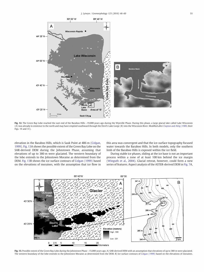
Fig. 12. The Green Bay Lobe reached the east end of the Baraboo Hills ~19,000 years ago during the Wyeville Phase. During this phase, a large glacial lake called Lake Wisconsin(A) was already in existence to the north andmay have emptied southward through the Devil's Lake Gorge (B) into theWisconsin River. Modified after Clayton and Attig (1989, theirFigs. 19 and 31).
55J. Lytwyn / Geomorphology 123 (2010) 46–60
elevation in the Baraboo Hills, which is Sauk Point at 486 m (Colgan,1999). Fig. 13A shows the possible extent of the Green Bay Lobe on theSAR-derived DEM during the Johnstown Phase, assuming thatelevations of up to 380 m were glaciated. The western boundary ofthe lobe extends to the Johnstown Moraine as determined from theDEM. Fig. 13B shows the ice surface contours of Colgan (1999) basedon the elevations of moraines, with the assumption that ice flow in
Fig. 13. Possible extent of the Green Bay Lobe during the Johnstown Phase ~15,000 years agoThe western boundary of the lobe extends to the Johnstown Moraine as determined from t
this area was convergent and that the ice-surface topography focusedwater towards the Baraboo Hills. In both models, only the southernlimb of the Baraboo Hills is exposed within the ice field.
During stable ice phases, sliding at the ice base is not an importantprocess within a zone of at least 100 km behind the ice margin(Winguth et al., 2004). Glacial retreat, however, could form a newseries of features. Aspect analysis of the ASTER-derived DEM in Fig. 7A,
. A) SAR-derived DEMwith an assumption that elevations of up to 380 mwere glaciated.he DEM. B) Ice surface contours of Colgan (1999) based on the elevations of moraines.
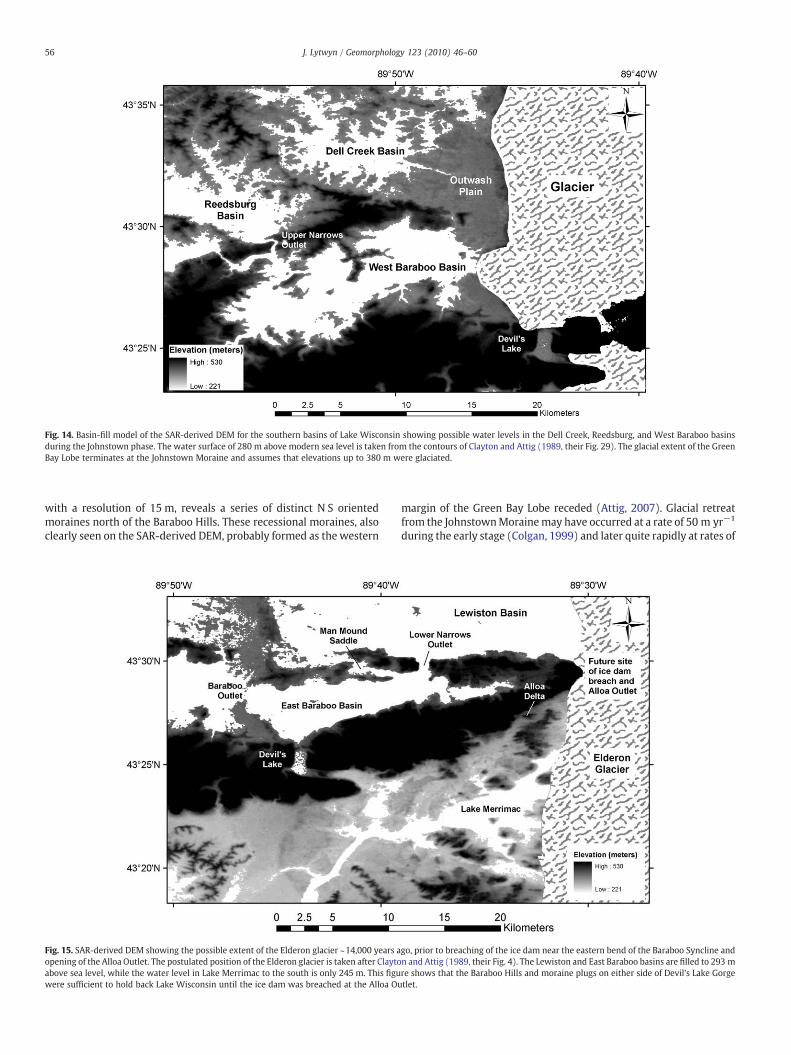
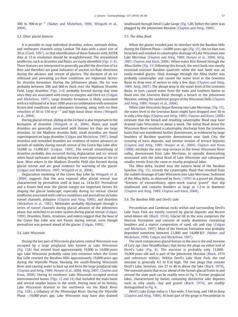
Fig. 14. Basin-fill model of the SAR-derived DEM for the southern basins of Lake Wisconsin showing possible water levels in the Dell Creek, Reedsburg, and West Baraboo basinsduring the Johnstown phase. The water surface of 280 m above modern sea level is taken from the contours of Clayton and Attig (1989, their Fig. 29). The glacial extent of the GreenBay Lobe terminates at the Johnstown Moraine and assumes that elevations up to 380 m were glaciated.
56 J. Lytwyn / Geomorphology 123 (2010) 46–60
with a resolution of 15 m, reveals a series of distinct N S orientedmoraines north of the Baraboo Hills. These recessional moraines, alsoclearly seen on the SAR-derived DEM, probably formed as the western
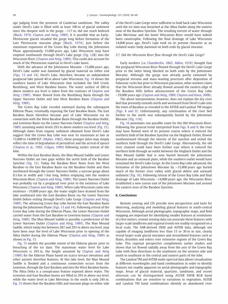
Fig. 15. SAR-derived DEM showing the possible extent of the Elderon glacier ~14,000 years aopening of the Alloa Outlet. The postulated position of the Elderon glacier is taken after Claytoabove sea level, while the water level in Lake Merrimac to the south is only 245 m. This figuwere sufficient to hold back Lake Wisconsin until the ice dam was breached at the Alloa Ou
margin of the Green Bay Lobe receded (Attig, 2007). Glacial retreatfrom the JohnstownMorainemay have occurred at a rate of 50 m yr−1
during the early stage (Colgan, 1999) and later quite rapidly at rates of
go, prior to breaching of the ice dam near the eastern bend of the Baraboo Syncline andn and Attig (1989, their Fig. 4). The Lewiston and East Baraboo basins are filled to 293 mre shows that the Baraboo Hills and moraine plugs on either side of Devil's Lake Gorgetlet.
57J. Lytwyn / Geomorphology 123 (2010) 46–60
300 to 900 m yr−1 (Maher and Mickelson, 1996; Winguth et al.,2004).
5.3. Other glacial features
It is possible to map individual drumlins, eskers, outwash deltas,and meltwater channels using Landsat TM data with a pixel size of30 m (Clark, 1997), so that identification of these features with ASTERdata at 15 m resolution should be straightforward. The streamlinedlandforms, such as drumlins andflutes, are easily identified (Figs. 2–4).These features are interpreted to generally parallel the direction of iceflow and therefore are good indicators of ancient ice-flow directionsduring the advance and retreat of glaciers. The duration of an icestillstand and prevailing ice-flow conditions are important factorsfor drumlin formation. During the Johnstown phase, the ice wasprobably between 200 and 600 m thick over the Madison DrumlinField. Large drumlins (Figs. 2-4) probably formed during that timesince they are associated with steep ice margins and thick ice (Colganand Mickelson, 1997). Large drumlin formation is likely associatedwith ice stillstand of at least 1000 years in combinationwith extensivefrozen-bed conditions and subsequent thawing, along with ice flowvelocities of 50 to 150 m yr−1 and high basal shear stress (Winguthet al., 2004).
During glacial retreat, sliding at the ice base is also important in theformation of drumlins (Winguth et al., 2004). Flutes and smalldrumlins are generally associated with thinner ice than are largedrumlins. In the Madison drumlin field, small drumlins are foundsuperimposed on large drumlins (Colgan and Mickelson, 1997). Smalldrumlins and remolded drumlins are evidence of minor advances orperiods of stability during overall retreat of the Green Bay Lobe after16,000 to 13,000 B.P. (Colgan, 1999). The overall streamlining ofdrumlins probably also occurred during deglaciation and ice retreatwhen basal meltwater and sliding became more important at the icebase. Most eskers in the Madison Drumlin Field also formed duringglacial retreat and are good evidence for warming of the glacier(Colgan and Mickelson, 1997; Winguth et al., 2004).
Deglaciation modeling of the Green Bay Lobe by Winguth et al.(2004) suggests that the area exposed after glacial retreat wascharacterized by permafrost until at least ca. 14 ka B.P. Permafrostand a frozen bed near the glacial margin are important factors forshaping the glacial landscape, especially during ice retreat. Glaciallandforms associatedwith cold ice conditions and permafrost includestunnel channels, polygons (Clayton and Attig, 1989), and drumlins(Mickelson et al., 1983). Meltwater probably discharged through aseries of tunnel channels during glacial advance of the Johnstownphase, but switched to an esker system during glacial retreat (Colgan,1999). Drumlins, flutes, striations, and eskers suggest that the base ofthe Green Bay Lobe was not frozen during retreat, even thoughpermafrost was present ahead of the glacier (Colgan, 1999).
5.4. Lake Wisconsin
During the last part of Wisconsin glaciation, centralWisconsin wasoccupied by a large proglacial lake known as Lake Wisconsin(Fig. 12A) that existed from approximately 19,000 to 14,000 yearsago. Lake Wisconsin probably came into existence when the GreenBay Lobe reached the Baraboo Hills approximately 19,000 years agoduring the Wyeville Phase, blocking the south-flowing WisconsinRiver and causing water to back up and form the large proglacial lake(Clayton and Attig, 1989; Hooyer et al., 2004; Attig, 2007; Clayton andKnox, 2008). During its existence, Lake Wisconsin occupied severalinterconnected basins (Figs. 12 and 14) that included the main basinand several smaller basins to the south. During most of its history,Lake Wisconsin drained to the northwest via the Black River(Fig. 12A), a tributary of the Mississippi River. During the WyevillePhase ~19,000 years ago, Lake Wisconsin may have also drained
southward through Devil's Lake Gorge (Fig. 12B) before the latter wasplugged by the Johnstown Moraine (Clayton and Attig, 1989).
5.5. The Alloa flood
When the glacier receded past its interface with the Baraboo Hillsduring the Elderon Phase ~14,000 years ago (Fig. 15), the ice damwasbreached and resulted in catastrophic drainage of LakeWisconsin intoLake Merrimac (Clayton and Attig, 1989; Hooyer et al., 2004; Attig,2007; Clayton and Knox, 2008). When water first flowed through theAlloa Outlet (Fig. 15) following this breach, the west bank was mostlyerosional-resistant Baraboo quartzite while the east bank was aneasily-eroded glacier. Final drainage through the Alloa Outlet wasprobably catastrophic and caused the water level in the LewistonBasin to drop tens of meters in only a few days (Clayton and Attig,1989; Attig, 2007). The abrupt drop in the water level of the LewistonBasin, in turn, caused water from the main and southern basins toflood into the Lewiston Basin through a breach in the JohnstownMoraine, cutting the sandstone gorges of theWisconsin Dells (Claytonand Attig, 1989; Hooyer et al., 2004).
When LakeWisconsin began flowing into Lake Merrimac (Fig. 15),the water level in the Lewiston Basin might have dropped over 30 min only a few days (Clayton and Attig, 1989). Clayton and Knox (2008)estimate that the breach and resulting catastrophic flood may havedrained Lake Wisconsin in about a week. The initial flood down theWisconsin River involved a catastrophic discharge from the Lewistonbasin that was manifested further downstream, as evidenced by largeboulders of Baraboo quartzite downstream near Sauk City, thescouring of loess deposits, and intense erosion of terrace deposits(Clayton and Attig, 1989; Hooyer et al., 2004). Clayton and Knox(2008) attribute the stair-step terraces in the lower Wisconsin Rivervalley, downstream from Lake Merrimac, to episodic downcuttingassociated with the initial flood of Lake Wisconsin and subsequentsmaller events from the same or nearby proglacial lakes.
The Alloa delta, located near the eastern bend of the BarabooSyncline (Fig. 15), records the catastrophic flood that resulted fromthe sudden drainage of LakeWisconsin into Lake Merrimac. Sedimentof the Alloa delta, as observed by Bretz (1950) in a gravel pit, display“foresets of extraordinary open-work coarse gravel” that dipsouthward and contains boulders as large as 1.5 m in diameter(Clayton and Attig, 1989; Clayton and Knox, 2008).
5.6. The Baraboo Hills and Devil's Lake
Precambrian and Cambrian rocks within and surrounding Devil'sLake State Park are mostly covered by glacial deposits and Recentwind-blown silt (Black, 1974). Glacial till in the area comprises theHoricon Formation and consists of sandy diamicton containingboulders and a matrix composition of sand, silt and clay (Colganand Mickelson, 1997). Most of the Horicon Formation was probablydeposited sometime between 21,000 and 14,000 B.P. (Maher andMickelson, 1996; Colgan and Mickelson, 1997).
Themost conspicuous glacial feature in the area is the endmoraineof Cary age (late Woodfordian) that forms the plugs on either end ofDevil's Lake (Fig. 8). The moraine is probably only 13,000–16,000 years old and is part of the Johnstown Moraine (Black, 1974and references within). Within Devil's Lake State Park, the endmoraine is generally 4.5 to 6 m high. The two plugs that containDevil's Lake, however, rise 27 to 40 m above the lake (Black, 1974).The outwash plains that occur ahead of the former glacial fronts in andaround the state park can be readily seen in Fig. 5. Former proglaciallakes, characterized by basins containing distinctive lake depositssuch as silty sands, clay and gravel (Black, 1974), are readilydistinguished in Fig. 8.
Devil's Lake Gorge today is 1 km wide, 5 km long, and 140 m deep(Clayton and Attig, 1989). At least part of the gorge is Precambrian in
58 J. Lytwyn / Geomorphology 123 (2010) 46–60
age judging from the presence of Cambrian sandstone. The valleyunder Devil's Lake is filled with at least 100 m of glacial sedimentsince the deepest well in the gorge, ~117 m, did not reach bedrock(Black, 1974; Clayton and Attig, 1989). It is possible that an Early-Pleistocene glacier invaded the gorge long before formation of theLate Pleistocene moraine plugs (Black, 1974). Just before themaximum expansion of the Green Bay Lobe during the JohnstownPhase approximately 15,000 years ago, Lake Wisconsin may haveemptied southwards through Devil's Lake gorge (Fig. 12B) into theWisconsin River (Clayton and Attig, 1989). This could also account formuch of the Pleistocene material in Devil's Lake basin.
With the advance of the Johnstown Moraine ~15,000 years ago,Devil's Lake outlet was dammed by glacial material on either end(Figs. 13 and 14). Devil's Lake, therefore, became an independentproglacial lake poised 40 m above Lake Wisconsin. Fig. 14 shows thesouthern basins of Lake Wisconsin that included the Dell Creek,Reedsburg, and West Baraboo basins. The water surface of 280 mabove modern sea level is taken from the contours of Clayton andAttig (1989). Water flowed from the Reedsburg Basin through theUpper Narrows Outlet and into West Baraboo Basin (Clayton andAttig, 1989).
The Green Bay Lobe receded eastward during the subsequentElderon Phase, eventually exposing the East Baraboo Basin. The EastBaraboo Basin therefore became part of Lake Wisconsin via itsconnection with the West Baraboo Basin through the Baraboo Outlet,and Lewiston Basin via the Lower Narrows Outlet (Clayton and Attig,1989) assuming water levels 293 m above modern sea level (Fig. 15).Although dates from organic sediment obtained from Devil's Lakesuggest that the Green Bay Lobe was near its maximum as late as13,000 to 14,000 B.P. (Maher, 1982), these younger dates may simplyreflect the time of degradation of permafrost and the arrival of spruce(Clayton et al., 1992; Colgan, 1999) following earlier retreat of thelobe.
Within the East Baraboo Basin, the Man Mound Saddle and LowerNarrows Outlet are two gaps within the north limb of the BarabooSyncline (Fig. 15). Today the Baraboo River flows from the WestBaraboo to the East Baraboo Basin via the Baraboo Outlet and thennorthward through the Lower Narrows Outlet, a narrow gorge about0.5 km in width and 1 km long, before emptying into the modernWisconsin River (Clayton and Attig, 1989). The Lower Narrows Outletwas probably cut by a preglacial river prior to the existence of LakeWisconsin (Clayton and Attig, 1989). When LakeWisconsin came intoexistence ~19,000 years ago, the water might have drained from thelake southward into the East Baraboo Basin via the Lower NarrowsOutlet before exiting through Devil's Lake Gorge (Clayton and Attig,1989). The advancing Green Bay Lobe buried the East Baraboo Basinduring the Johnstown Phase (Figs. 13 and 14). Following retreat of theGreen Bay Lobe during the Elderon Phase, the Lower Narrows Outletcarried water from the East Baraboo to Lewiston basins (Clayton andAttig, 1989). The Man Mound Saddle is possibly a predecessor of theLower Narrows Outlet (Clayton and Attig, 1989). The Man MoundSaddle, which today lies between 287 and 293 m above sea level, mayhave been near the level of Lake Wisconsin prior to opening of theAlloa Outlet during the Elderon Phase (Clayton and Attig, 1989) asshown in Fig. 15.
Fig. 15 models the possible extent of the Elderon glacier prior tobreaching of the ice dam. The maximum water level for LakeWisconsin is 293 m, the height assumed by Clayton and Attig(1989) for the Elderon Phase based on scarce terrace elevations andother ancient shoreline features. At this lake level, the Man MoundSaddle is flooded and a continuous connection occurs from theLewiston, through the East Baraboo and into theWest Baraboo basins.The Alloa Delta is a conspicuous feature exposed above water. TheLewiston and East Baraboo basins are filled to 293 m above sea level,while the water level in Lake Merrimac to the south is only 245 m.Fig. 15 shows that the Baraboo Hills and moraine plugs on either side
of the Devil's Lake Gorge were sufficient to hold back Lake Wisconsinuntil the ice dam was breached at the Alloa Outlet along the easternnose of the Baraboo Syncline. The resulting torrent of water throughLake Merrimac and the lower Wisconsin River would have indeedbeen catastrophic. Following the final drainage of Lake Wisconsin14,000 years ago, Devil's Lake took on its present character as anisolated water body dammed on both ends by glacial moraine.
5.7. Did the Wisconsin River flow through the Devil's Lake Gorge?
Early workers (i.e. Chamberlin, 1883; Alden, 1918) thought thatthe preglacial Wisconsin River flowed through the Devil's Lake Gorgeprior to the latter being blocked on both ends by the JohnstownMoraine. Although the gorge was already partly exhumed bypreglacial streams and mass-wasting processes after deposition ofPaleozoic rocks but prior toWisconsin glaciation, other workers claimthat the Wisconsin River already flowed around the eastern edge ofthe Baraboo Hills before advancement of the Green Bay Lobe~19,000 years ago (Clayton and Attig, 1989; Clayton and Knox, 2008).
The above interpretation, however, does not explain the dry riverbed that presently extends north and westward from Devil's Lake intothe town of Baraboo as revealed in the ASTER and Landsat TM images(Figs. 8 and 9). Unfortunately, any continuation of the river bedfurther to the north was subsequently buried by the JohnstownMoraine (Fig. 11A).
Fig. 16 postulates one possible route for the Old Wisconsin River.Following the general trend interpreted from Figs. 8 and 9, the rivermay have flowed west of its present course where it entered thenorthern limb of the Baraboo Syncline via the Hogback Outlet, flowedsoutheastward through the interior of the syncline and exited thesouthern limb through the Devil's Lake Gorge. Alternatively, the oldriver channel could have been further east where it entered thenorthern limb through an outlet between the Hogback Outlet and theMan Mound Saddle that is now buried beneath the JohnstownMoraine and an outwash plain, while the southern outlet would haveremained the Devil's Lake Gorge. As the Green Bay Lobe advanced, theformation of the Johnstown Moraine by ~15,000 years ago buriedmuch of the former river valley with glacial debris and outwashsediment (Fig. 16). Following retreat of the Green Bay Lobe and finaldrainage of Lake Wisconsin ~14,000 years ago, the Wisconsin Riverestablished a new course east of the Johnstown Moraine and aroundthe eastern nose of the Baraboo Syncline.
6. Conclusions
Remote sensing and GIS provide new perspectives and tools forobserving, analyzing and modeling glacial features in south-centralWisconsin. Although aerial photographs, topographic maps, and fieldmapping are important for identifying smaller features at resolutionsof a fewmeters, remote sensing data can associate these features withlarger-scale landforms and regional trends not readily recognized on alocal scale. The SAR-derived DEM and ASTER data, although notcapable of imaging landforms less than 15 or 30 m in size, clearlyreveal larger-scale glacial moraines and streamlined features such asflutes, drumlins and eskers over extensive regions of the Green BayLobe. This regional perspective compliments earlier studies andshows that ice flowed radially away from the axis of the Green BayLobe with flow directions to the southwest on the western side andsouth to southeast in the central and eastern parts of the lobe.
The Landsat TM and ASTERmulti-spectral data allows visualizationat different wavelengths and band combinations in order to identifyfeatures not readily apparent on aerial photographs and topographicmaps. Areas of glacial material, quartzite, sandstone, and recentalluvium can be distinguished using ASTER SWIR RGB bandcombinations that are sensitive to variations in vegetation. ASTERand Landsat TM band combinations identify an abandoned river
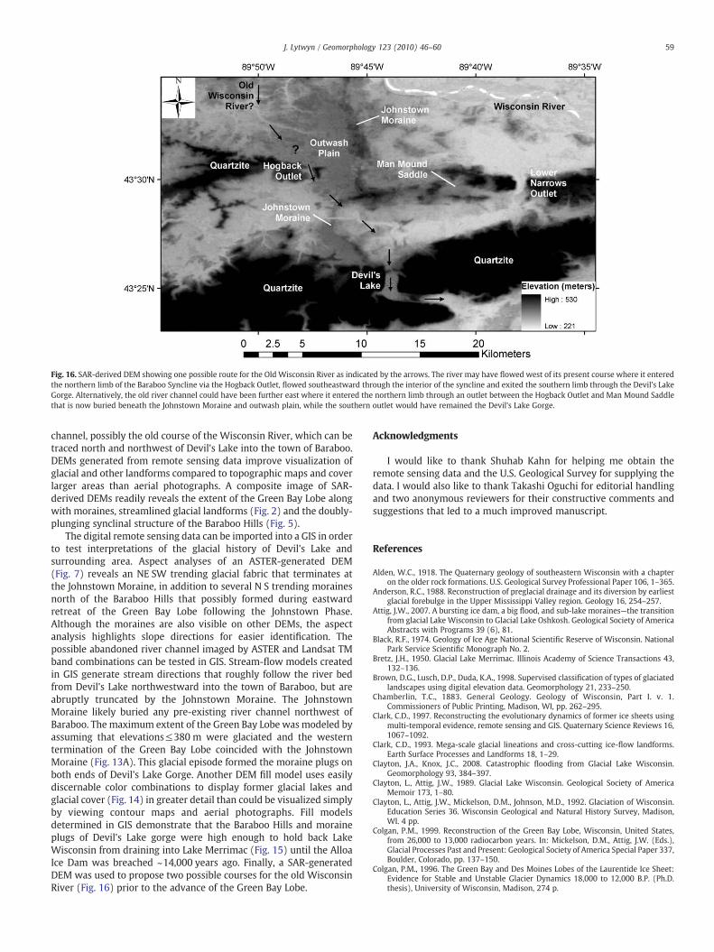
Fig. 16. SAR-derived DEM showing one possible route for the Old Wisconsin River as indicated by the arrows. The river may have flowed west of its present course where it enteredthe northern limb of the Baraboo Syncline via the Hogback Outlet, flowed southeastward through the interior of the syncline and exited the southern limb through the Devil's LakeGorge. Alternatively, the old river channel could have been further east where it entered the northern limb through an outlet between the Hogback Outlet and Man Mound Saddlethat is now buried beneath the Johnstown Moraine and outwash plain, while the southern outlet would have remained the Devil's Lake Gorge.
59J. Lytwyn / Geomorphology 123 (2010) 46–60
channel, possibly the old course of the Wisconsin River, which can betraced north and northwest of Devil's Lake into the town of Baraboo.DEMs generated from remote sensing data improve visualization ofglacial and other landforms compared to topographic maps and coverlarger areas than aerial photographs. A composite image of SAR-derived DEMs readily reveals the extent of the Green Bay Lobe alongwith moraines, streamlined glacial landforms (Fig. 2) and the doubly-plunging synclinal structure of the Baraboo Hills (Fig. 5).
The digital remote sensing data can be imported into a GIS in orderto test interpretations of the glacial history of Devil's Lake andsurrounding area. Aspect analyses of an ASTER-generated DEM(Fig. 7) reveals an NE SW trending glacial fabric that terminates atthe Johnstown Moraine, in addition to several N S trending morainesnorth of the Baraboo Hills that possibly formed during eastwardretreat of the Green Bay Lobe following the Johnstown Phase.Although the moraines are also visible on other DEMs, the aspectanalysis highlights slope directions for easier identification. Thepossible abandoned river channel imaged by ASTER and Landsat TMband combinations can be tested in GIS. Stream-flow models createdin GIS generate stream directions that roughly follow the river bedfrom Devil's Lake northwestward into the town of Baraboo, but areabruptly truncated by the Johnstown Moraine. The JohnstownMoraine likely buried any pre-existing river channel northwest ofBaraboo. The maximum extent of the Green Bay Lobe was modeled byassuming that elevations≤380 m were glaciated and the westerntermination of the Green Bay Lobe coincided with the JohnstownMoraine (Fig. 13A). This glacial episode formed the moraine plugs onboth ends of Devil's Lake Gorge. Another DEM fill model uses easilydiscernable color combinations to display former glacial lakes andglacial cover (Fig. 14) in greater detail than could be visualized simplyby viewing contour maps and aerial photographs. Fill modelsdetermined in GIS demonstrate that the Baraboo Hills and moraineplugs of Devil's Lake gorge were high enough to hold back LakeWisconsin from draining into Lake Merrimac (Fig. 15) until the AlloaIce Dam was breached ~14,000 years ago. Finally, a SAR-generatedDEM was used to propose two possible courses for the old WisconsinRiver (Fig. 16) prior to the advance of the Green Bay Lobe.
Acknowledgments
I would like to thank Shuhab Kahn for helping me obtain theremote sensing data and the U.S. Geological Survey for supplying thedata. I would also like to thank Takashi Oguchi for editorial handlingand two anonymous reviewers for their constructive comments andsuggestions that led to a much improved manuscript.
References
Alden, W.C., 1918. The Quaternary geology of southeastern Wisconsin with a chapteron the older rock formations. U.S. Geological Survey Professional Paper 106, 1–365.
Anderson, R.C., 1988. Reconstruction of preglacial drainage and its diversion by earliestglacial forebulge in the Upper Mississippi Valley region. Geology 16, 254–257.
Attig, J.W., 2007. A bursting ice dam, a big flood, and sub-lake moraines—the transitionfrom glacial Lake Wisconsin to Glacial Lake Oshkosh. Geological Society of AmericaAbstracts with Programs 39 (6), 81.
Black, R.F., 1974. Geology of Ice Age National Scientific Reserve of Wisconsin. NationalPark Service Scientific Monograph No. 2.
Bretz, J.H., 1950. Glacial Lake Merrimac. Illinois Academy of Science Transactions 43,132–136.
Brown, D.G., Lusch, D.P., Duda, K.A., 1998. Supervised classification of types of glaciatedlandscapes using digital elevation data. Geomorphology 21, 233–250.
Chamberlin, T.C., 1883. General Geology. Geology of Wisconsin, Part I. v. 1.Commissioners of Public Printing, Madison, WI, pp. 262–295.
Clark, C.D., 1997. Reconstructing the evolutionary dynamics of former ice sheets usingmulti-temporal evidence, remote sensing and GIS. Quaternary Science Reviews 16,1067–1092.
Clark, C.D., 1993. Mega-scale glacial lineations and cross-cutting ice-flow landforms.Earth Surface Processes and Landforms 18, 1–29.
Clayton, J.A., Knox, J.C., 2008. Catastrophic flooding from Glacial Lake Wisconsin.Geomorphology 93, 384–397.
Clayton, L., Attig, J.W., 1989. Glacial Lake Wisconsin. Geological Society of AmericaMemoir 173, 1–80.
Clayton, L., Attig, J.W., Mickelson, D.M., Johnson, M.D., 1992. Glaciation of Wisconsin.Education Series 36. Wisconsin Geological and Natural History Survey, Madison,WI. 4 pp.
Colgan, P.M., 1999. Reconstruction of the Green Bay Lobe, Wisconsin, United States,from 26,000 to 13,000 radiocarbon years. In: Mickelson, D.M., Attig, J.W. (Eds.),Glacial Processes Past and Present: Geological Society of America Special Paper 337,Boulder, Colorado, pp. 137–150.
Colgan, P.M., 1996. The Green Bay and Des Moines Lobes of the Laurentide Ice Sheet:Evidence for Stable and Unstable Glacier Dynamics 18,000 to 12,000 B.P. (Ph.D.thesis), University of Wisconsin, Madison, 274 p.
60 J. Lytwyn / Geomorphology 123 (2010) 46–60
Colgan, P.M., Mickelson, D.M., 1997. Genesis of streamlined landforms and flow historyof the Green Bay Lobe, Wisconsin, USA. Sedimentary Geology 111, 7–25.
Dalziel, I.W.D., Dott Jr., R.H., 1970. Geology of the Baraboo district, Wisconsin.Wisconsin Geological and Natural History Survey Information Circular, 14. 143 pp.
Defrates, J., 2007. Origin of second-generation mesoscale folds and crenulation cleavagein the Baraboo Syncline, Wisconsin. Geological Society of America Abstracts withPrograms 39 (6), 233.
Dunlop, P., Clark, C.D., 2006. Distribution of ribbed moraine in the Lac NaococaneRegion, Central Québec, Canada. Journal of Maps 2006, 59–70.
Hobbs, H.C., 1997. The preglacial Upper Mississippi River flowed north and west intothe Arctic Ocean. Geological Society Abstracts with Programs 29, 20.
Hobbs, H.C., 1999. Origin of the Driftless Area by subglacial drainage — a newhypothesis. In: Mickelson, D.M., Attig, J.W. (Eds.), Glacial Processes Past andPresent: Geological Society of America Special Paper 337, Boulder, pp. 93–102.
Hooyer, T., Schoephoester, P., Mode, W.N., Clayton, L., Attig, J., 2004. Glacial outburstfloods from proglacial lakes in Wisconsin. Geological Society of America Abstractswith Programs 36 (5), 281.
Imbrie, J., Imbrie, K.P., 1979. Ice ages: solving the mystery. Enslow Publishers, NewJersey. 224 pp.
Imlay, M.J., 1973. A case for protecting the Driftless Area of the Upper Midwest.Malacological Review 6, 64–65.
Jensen, J.R., 2007. Remote Sensing of the Environment. Pearson Prentice Hall, NewJersey. 592 pp.
Maher Jr., L.J., 1982. The palynology of Devil's Lake, Sauk County, Wisconsin. In: Knox, J.C.,Clayton, L., Mickelson, D.M. (Eds.), QuaternaryHistory of the Driftless Area.WisconsinGeological and Natural History Survey Field Trip Guide Book Number 5, University ofWisconsin-Extension: Geological and Natural History Survey, Madison, WI.
Maher Jr., L.J., Mickelson, W.H., 1996. Palynological and radiocarbon evidence fordeglaciation events in the Green Bay Lobe, Wisconsin. Quaternary Reseaech 46,251–259.
Medaris Jr., L.G., Singer, B.S., Dott Jr., R.H., Naymark, A., Johnson, C.M., Schott, R.C., 2003.Late Paleoproterozoic climate, tectonics, and metamorphism in the southern LakeSuperior region and Proto-North America: evidence from Baraboo intervalquartzites. The Journal of Geology 111, 243–257.
Mickelson, D.M., Clayton, L., Fullerton, D.S., Borns Jr., H.W., 1983. The late Wisconsinglacial record of the Laurentide Ice Sheet in the United States. In: Porter, S. (Ed.),The Late Pleistocene. University of Minnesota Press, Minneapolis, pp. 3–37.
Smith, G.R., Woodward, J.C., Heywood, D.I., Gibbard, P.L., 2000. Interpreting Pleistoceneglacial features from SPOT HRV data using fuzzy techniques. Computers andGeosciences 26, 479–490.
Smith, M.J., Rose, J., Booth, S., 2006. Geomorphological mapping of glacial landformsfrom remotely sensed data: an evaluation of the principal data sources and anassessment of their quality. Geomorphology 76, 148–165.
Thwaites, F.T., Twenhofel, W.H., 1921.Windrow Formation: an upland gravel formationof the Driftless and adjacent areas of the upper Mississippi valley. GeologicalSociety of America Bulletin 32, 293–314.
Trowbridge, A.C., 1921. The erosional history of the Driftless area. University of IowaStudies in Natural History 9, 55–127.
VanWyck, N., Norman, M., 2004. Detrital zircon ages from Early Proterozoic quartzites,Wisconsin, support rapid weathering and deposition of mature quartz arenites. TheJournal of Geology 112, 305–315.
Winguth, C., Mickelson, D.M., Colgan, P.M., Laabs, B.J.C., 2004. Modeling the deglaciationof the Green Bay Lobe of the southern Laurentide Ice Sheet. Boreas 33, 34–47.