Embed Size (px)
Citation preview
Remarks on the hydrogeologie of the Nile delta, U.A.R.
4. K I M R E Y , J .O . (1965): "Description of the Pungo River Formation", North Carolina Department of Conservation and Development, Raleigh, N . C . , Bulletin N o . 79, 131 pp.
5. L E G R A N D , H . E . , "Geology and Ground-Water Resources of Wilmington-New Bern Area", North Carolina Department of Conservation and Development, Raleigh, N . C . , Ground-Water Bulletin, N o . 1, 70 pp., 1960.
6. N E L S O N , P. F. and P E E K , H . M . (1964): "Preliminary Report on Ground Water in Beauford County", North Carolina Department of Water Resources, Raleigh, N . C . , 25 pp.
7. U P S O N , J.E. (1959): "Ground-Water Problems in N e w York and N e w England", Journal of the Hydraulics Division, American Society of Civil Engineers, pp. 1-12.
Remarks on the hydrogeology of the Nile Delta, U A R
A . Shata and I. El Fayoumy
Desert Institute, El Mataría, Cairo
S U M M A R Y : The Nile Delta (22,000 k m 2 ) , occupying a portion of the gulf area dominating Egypt in Pliocene times, acts as an important reservoir for ground water. In this reservoir, the strata of hydrologie importance are composed of sands and gravels (Pleistocene and Holocene) which have a thickness exceeding 300 m . The Water contained in such strata (salinity of the order of 500 p p m ) exists generally under unconfined conditions and depends for its source upon the surface water of the Nile (main branches as well as the irrigation canals) and upon the intermittent surface runoff of the adjacent desert areas. In this paper all aspects of hydrophysiography, hydrostrati-graphy, hydrostructure, hydrochemistry and hydrology of the Nile Delta are discussed.
R É S U M É : Le delta du Nil (22.000 k m 2 ) qui à l'époque du pliocène s'étendait sur une partie du golfe qui baignait l'Egypte, agit c o m m e un important réservoir pour l'eau souterraine. Les couches d'importance hydrologique de ce réservoir sont formées de sables et de graviers (pleistocene et holocène) d'une épaisseur de plus de 300 m . L'eau contenue dans ces couches (salinité de l'ordre de 500 p p m ) est à niveau libre et est alimentée par les eaux de surface du Nil (des bras majeurs, c o m m e des canaux d'irrigation) et des cours d'eau intermittents des régions adjacentes du désert.
Dans la présente communication on examine le delta du Nil du point de vue hydrophysiogra-phique, hydrostratigraphique, hydrostructural, hydrochimique et hydrologique.
INTRODUCTION
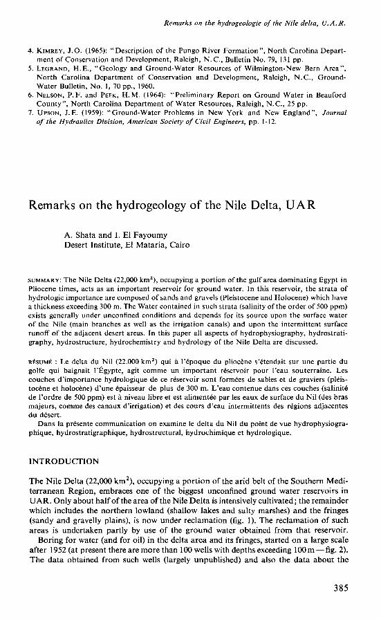
The Nile Delta (22,000 k m 2 ) , occupying a portion of the arid belt of the Southern Mediterranean Region, embraces one of the biggest unconfined ground water reservoirs in U A R . Only about half of the area of the Nile Delta is intensively cultivated ; the remainder which includes the northern lowland (shallow lakes and salty marshes) and the fringes (sandy and gravelly plains), is n o w under reclamation (fig. 1). The reclamation of such areas is undertaken partly by use of the ground water obtained from that reservoir.
Boring for water (and for oil) in the delta area and its fringes, started on a large scale after 1952 (at present there are more than 100 wells with depths exceeding 100 m — fig. 2). The data obtained from such wells (largely unpublished) and also the data about the
385
A. Sha ta and I. El Fayoumy
FIGURE 1.
LAÑO RECLAMATION PROJECTS AROUND NILE DELTA
- v**1 • m j¿¿/yyy// • • k K**+<¿
m m m \ M « ^ . > J
cOOOObVk * *
_^r^
^é " W7
rZ * „ \ K
~ •_-
l OOVJ /Y/y
*
^
^
íP r̂~ tl
¿r* ' • « « • •
-_-. "-~-^ y
"̂ ^—
• J / O cO
• • \ o • V • —Jrtfl \
/ L i A I
^ . Hflt Dalla Cultivât** Lan* V a ' »••*«» *•»»«
r-I S I I I N Clayay S*Jl*
Calcar Saut
Upland Otatrt
"7N
DEEP BORING FOR WATER IN
MLE OELtA
FIGURE 2.
386
Remarks on the hydrogeology of the Nile delta, UA R
FIGURE 3.
NILE PRE.DELTA
NILE PRODELTA
FIGURE 4.
387
A. Sha ta and I. El Fayoumy
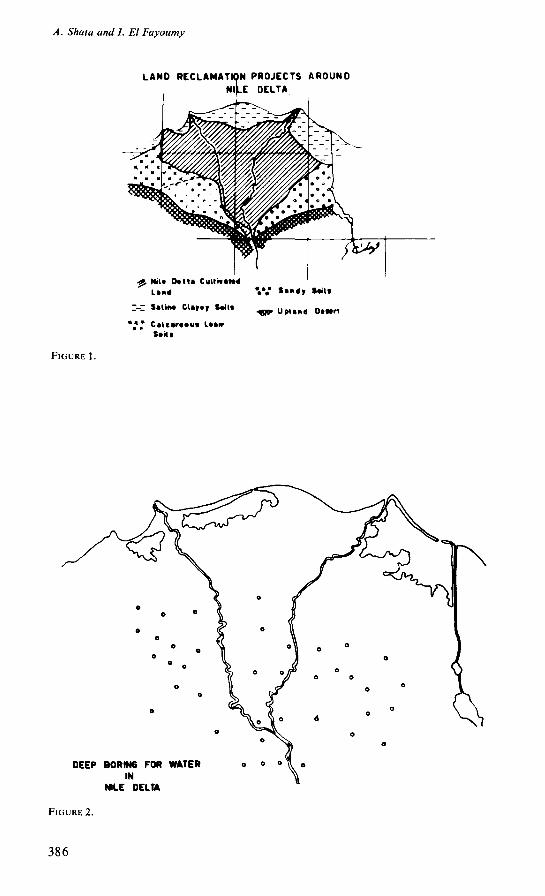
geology and the hydrology of the Nile Delta, which are mainly contained in the work of Shotton (1946), R E G W A (1962) Hashim et al. (1963), Soleit (1964), Nassef (1962), Shata (1966) and El Fayoumy (1965 and 1968), are used in the preparation of the present paper. The detailed studies, undertaken by the authors during the past ten years, for most of the delta basin (Predelta and Prodelta—figs. 3 and 4), add a lot to our knowledge, particularly in regard to the geomorphology and the geology.
In these remarks on the hydrogeology of the Nile Delta, emphasis will be given to the geological aspects, the hydrochemical aspects and eventually the hydrological aspects. In discussing all such aspects, m u c h detail will be omitted.
GEOLOGICAL ASPECTS
H YDROPH YSIOGRAPH Y
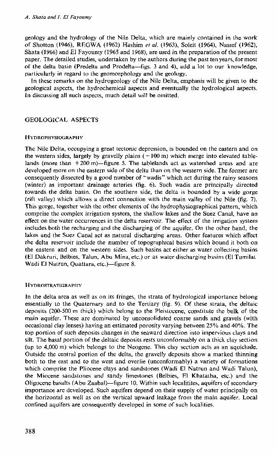
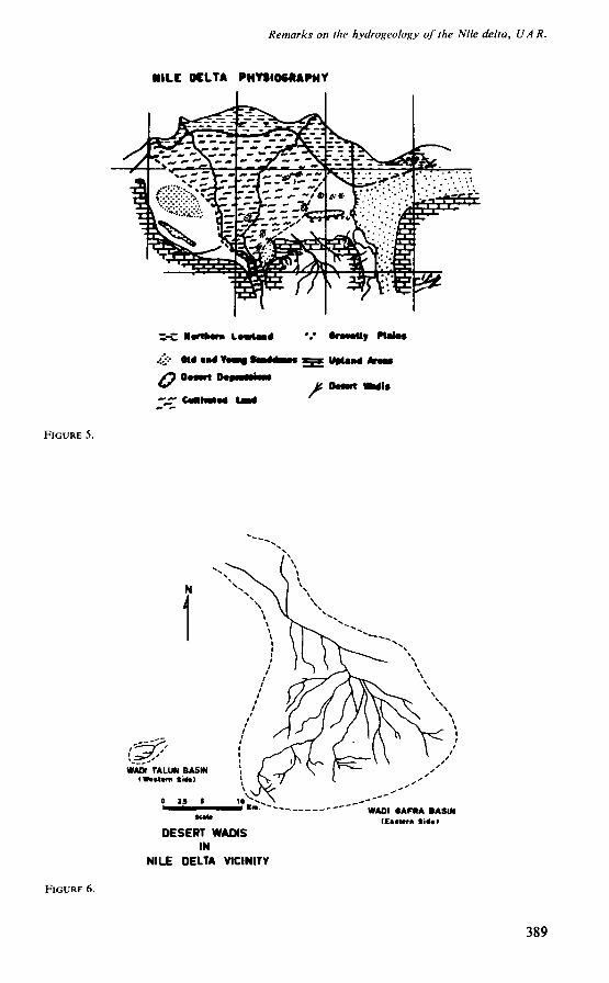
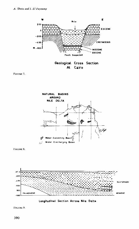
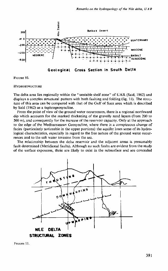
The Nile Delta, occupying a great tectonic depression, is bounded on the eastern and on the western sides, largely by gravelly plains ( +100 m ) which merge into elevated tablelands (more than + 200 m)—figure 5. The tablelands act as watershed areas and are developed more on the eastern side of the delta than on the western side. The former are consequently dissected by a good number of "wadis" which act during the rainy seasons (winter) as important drainage arteries (fig. 6). Such wadis are principally directed towards the delta basin. O n the southern side, the delta is bounded by a wide gorge (rift valley) which allows a direct connection with the main valley of the Nile (fig. 7). This gorge, together with the other elements of the hydrophysiographical pattern, which comprise the complex irrigation system, the shallow lakes and the Suez Canal, have an effect on the water occurrences in the delta reservoir. The effect of the irrigation system includes both the recharging and the discharging of the aquifer. O n the other hand, the lakes and the Suez Canal act as natural discharging areas. Other features which affect the delta reservoir include the number of topographical basins which bound it both on the eastern and on the western sides. Such basins act either as water collecting basins (El Dakruri, Belbies, Talun, A b u Mina, etc.) or as water discharging bisins (El Tumilat W a d i El Natrun, Quattara, etc.)—figure 8.
HYDROSTRATIGRAPHY
In the delta area as well as on its fringes, the strata of hydrological importance belong essentially to the Quaternary and to the Tertiary (fig. 9). O f these strata, the deltaic deposits (200-500 m thick) which belong to the Pleistocene, constitute the bulk of the main aquifer. These are dominated by unconsolidated coarse sands and gravels (with occasional clay lenses) having an estimated porosity varying between 25% and 40%. The top portion of such deposits changes in the seaward direction into impervious clays and silt. The basal portion of the deltaic deposits rests unconformably on a thick clay section (up to 4,000 m ) which belongs to the Neogene. This clay section acts as an aquiclude. Outside the central portion of the delta, the gravelly deposits show a marked thinning both to the east and to the west and overlie (unconformably) a variety of formations which comprise the Pliocene clays and sandstones (Wadi El Natrun and Wadi Talun), the Miocene sandstones and sandy limestones (Belbies, El Khatatba, etc.) and the Oligocène basalts (Abu Zaabal)—figure 10. Within such localities, aquifers of secondary importance are developed. Such aquifers depend on their supply of water principally on the horizontal as well as on the vertical upward leakage from the main aquifer. Local confined aquifers are consequently developed in some of such localities.
388
Remarks on the hydrogeology of the Nile delta, U A R.
MILC K L T A PHYSIOGRAPHY
--Z HarHMnt L M t M <
¿y O U Mtf »«
y O OMart Oap
•ravally Plata*
/
FIGURE 5.
FIGURE 6.
WAOI SAFRA BASIN (Eastern Sitf«l
DESERT WAOIS IN
NILE DELTA VICINITY
389
A. Sha ta and I. El Fayoumy
FIGURE 8.
EOCENE
RETACEÓOS
M.-eooJ
Fault Suspected
FIGURE 7.
Geological Cross Section
At Cairo
NATURAL BASINS AROUND
NILE DELTA
*P W»ter Collecting BasinVi
±-_- Water Discharging Basin
BUATCRhARY
Longitudinal Section Across Nile Delta
FIGURE 9.
390
Remarks on the hydrogeology of the Nile delta, UA R
it
it
it
N Belbiei Deurt
Geological Cross Section in South Delta
FIGURE 10.
H YDROSTRUCTURE
The delta area lies regionally within the "unstable shelf zone" of U A R (Said, 1962) and displays a complex structural pattern with both faulting and folding (fig. 11). The structure of this area can be compared with that of the Gulf of Suez area which is described by Said (1962) as a taphrogeosyncline.
F r o m the point of view of the ground water occurrences, there is a regional northward dip which accounts for the marked thickening of the gravelly sand layers (from 200 to 500 m ) , and consequently for the increase of the reservoir capacity. Only at the approach to the edge of the Mediterranean Geosyncline, where there is a conspicuous change of faciès (particularly noticeable in the upper portions) the aquifer loses some of its hydro-logical characteristics, especially in regard to the free nature of the ground water occurrences and to the salt water invasion from the sea.
The relationship between the delta reservoir and the adjacent areas is presumably fault determined (Meridional faults). Although no such faults are evident from the study of the surface exposures, these are likely to exist in the subsurface and are concealed
NILE DELTA
STRUCTURAL ZONES
FIGURE 11.
391
A. Shata and I. El Fayoumy
underneath the Quaternary deposits. Towards the southern portion of the delta, faulting is more prominent and there is undoubted development of a graben structure. The existing faults are presumably arranged in echelon and show locally a vertical displacement of the order of 500 m . In this portion of the delta, the faults account generally for the development of favourable conditions for the movement of the water into the bounding rocky layers and consequently the formations of reservoirs of the second order. Locally, however, unfavourable conditions are likely to exist, particularly where the fault planes are sealed by basalt and/or quartzites (no evidence).
With regard to the occurrence of faulting in the northern portion of the delta, reference will be given to the two important latitudinal faults, A b u H a m m a d on the eastern side and Ruzze on the western side. These two faults, having a vertical displacement (downthrow side to the north) of the order of 1,000 m , formed originally one line which was then subjected to horizontal dislocation by the meridional faults of the southern delta. It seems possible that the nature of the reservoir and its surroundings in the southern portion of the delta are different from the northern portion. Furthermore, in the northern portion, the meridional faults are not clearly evident and are presumably deep seated. The existence of strong folds (similar to North Sinai) which were truncated, is not improbable in the subsurface. Within the surface horizons, the transition from the main reservoir to the delta fringes is almost gradational i.e. without conspicuous faulting.
H Y D R O C H E M I C A L ASPECTS
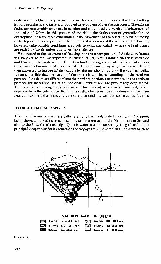
The ground water of the main delta reservoir, has a relatively low salinity (500 p p m ) , but it shows a marked increase in salinity at the approach to the Mediterranean Sea and also to the Suez Canal area (fig. 12). This water is characterised by a high N a % and is principally dependent for its source on the seepage from the complex Nile system (surface.
SALINITY MAP OF OELTA I | Salinity < , - 320 ppm \. ,'\ Salinity 12*0 - 1920 ppnx
K Ü 3 Salinity 3 20-640 ppm I.VI Salinity 1920-2560 P»m
I B M Salinity 640-1210 ppm Salinity > -2560 ppm
FIGURE 12.
392
Remarks on the hydrogeology of the Nile delta, V A R
and subsurface). Since the formation of the delta reservoir, the chemistry of this water has been subjected to several alterations which can be attributed to four main factors:
1. Sedimentological processes due to the original formation of the deltaic deposits (aquifer) ;
2. Annual infiltration due to runoff from the adjacent desert areas ; 3. Invasion of saline water from the Mediterranean Sea; 4. Cation exchange reactions.
Towards the eastern portion of the delta reservoir, the water shows a relatively high salinity (5,000 p p m ) and certain amounts of sulphates and chloride. O n the other hand, towards the northern portion, the water becomes highly saline (15,000 p p m ) and shows ionic ratios and coefficients typical of sea water. This drastic change is due both to the continuous leaching of the water bearing strata (having inherited high salinity characteristics due to deposition under fluviomarine conditions) and to direct salt water invasion.
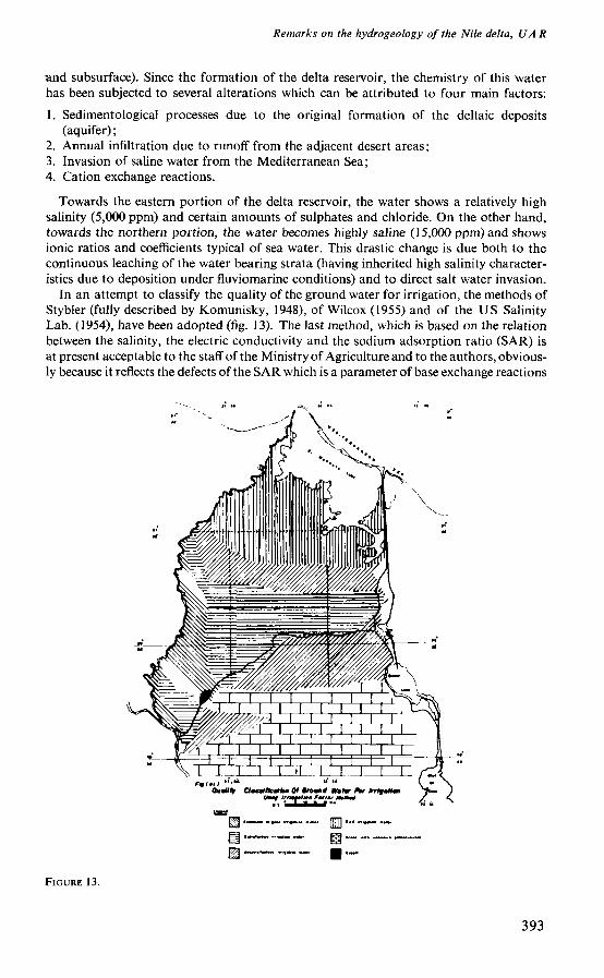
In an attempt to classify the quality of the ground water for irrigation, the methods of Stybler (fully described by Komunisky, 1948), of Wilcox (1955) and of the U S Salinity Lab. (1954), have been adopted (fig. 13). The last method, which is based on the relation between the salinity, the electric conductivity and the sodium adsorption ratio ( S A R ) is at present acceptable to the staff of the Ministry of Agriculture and to the authors, obviously because it reflects the defects of the S A R which is a parameter of base exchange reactions
FIGURE 13.
393
A. Shata and I. El Fayoumy
FIGURE 14.
NILE DELTA HYDROGRAPHY
^/ Canal!
_ _ , ' Drains
Lakti
FIGURE 15.
394
Remarks on the hydrogeology of the Nile delta, U A R
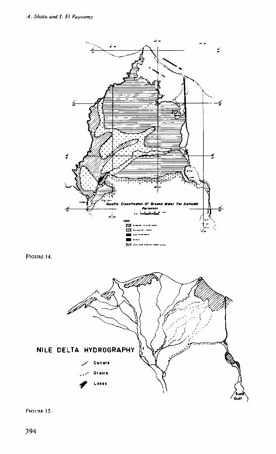
A s for the classification of the ground water of the delta reservoir, for domestic purposes, figure 14, reference is m a d e to the standard concentrations (Fe and M n ^ O . 3 p p m , M g 125 p p m , CI 250 p p m , S o 4 250 p p m , and T D S 500 to 1,000 p p m ) given by the U S Public Health Division (1944).
HYDROLOGICAL ASPECTS
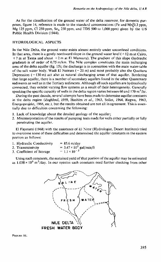
In the Nile Delta, the ground water exists almost entirely under unconfined conditions. In that area, there is a gently northward slope in the ground water level ( + 12 m at Cairo, + 7 m at Tanta and about + 2 m at El Mansura). The gradient of this slope (hydraulic gradient) is of order of 0.75 m / k m . The Nile complex constitutes the main recharging area of the delta aquifer (fig. 15); the discharge is in connection with the main water-table of the salt water body. W a d i El Natrum ( — 20 m ) and most probably also the Quattara Depression ( — 130 m ) act also as natural discharging areas of that aquifer. Bordering that large aquifer, there is a number of secondary aquifers found in the other Quaternary sediments as well as in the Tertiary sediments. Although all such aquifers are hydraulically connected, they exhibit varying flow systems as a result of their heterogeneity. Generally speaking the specific capacity of wells in the delta region varies between 60 and 170 m 3 / h r .
During the past decade, several attempts have been m a d e to determine aquifer constants in the delta region (Zaghloul, 1959, Hashim et al., 1963, Soliet, 1964, R e g w a , 1963, Energoprojekt, 1966, etc.), but the results obtained are not all in agreement. This is essentially due to difficulties concerning the following:
1. Lack of knowledge about the detailed geology of the aquifer; 2. Misinterpretation of the results of pumping tests m a d e for wells either partially or fully
penetrating the aquifer.
El Fayoumi (1968) with the assistance of El N i m r (Hydrologist, Desert Institute) tried to overcome some of these difficulties and determined the aquifer constants in the eastern portion as follows:
1. Hydraulic Conductivity = 85.6 m / d a y 2. Transmissivity = 3.47 x 10⁵ gal/min/ft 3. Coefficient of Storage = 1.1 x io - 3
Using such constants, the sustained yield of that portion of the aquifer m a y be estimated as 1.038 x 10⁶ m 3 / d a y . In our opinion such constants need further checking from other
FIGURE 16.
395
Ted Arnow, J. H. Feth, and R. W. Mower
places and it will be several years before such constants are determined in a final way and can be applied adequately to the delta reservoir (fig. 16).
Nevertheless acceptable values of the porosity and the permeability in the delta aquifer are 2 5 % and 75 m 3 / d a y respectively. Use of such values leads to an estimate of the capacity of the reservoir as 500 milliard cubic metres (500 x 109 m 3 ) and the amount of water passing through it to the sea (February to July 1958) as 0.37 milliard cubic metres (0.37 x 1 0 - m 3 ) .
REFERENCES
1. Energoprojekt (1966): Report on the land Reclamation Project, in El Multak Area, U A R . 2. H A R D E N B E R G H , W . A . (1953): Water Supply and Purification, Inter. Textbook Comp. Scranton,
Pennsylvania, U S A . 3. H A S H I M , A . et al. (1963): Report on the Ground Water in The Nile valley, Publication of The
Ministry of Irrigation, Cairo, Egypt. 4. K A M E N S K Y , G . N . (1947): Search and Exploration for Underground Water (in Russian),
Gesgeolisdat, Moscow, Leningrad. 5. N A S S E F , E . (1962): Search for Ground Water. Exploitation and suitability in U A R . Bull.
Fac. Eng. Ain Shams Univ., Cairo, Egypt. 6. R E G W A (1963): Report on the Fround Water in El Tahrir province (in Arabic). R E G W A
Company, Cairo, Egypt. 7. S A I D , R . (1967): Geology of Egypt, Elsevier, Amsterdam. 8. S H A T A , A . A . and E L F A Y O U M Y , I.F. (1963): Report on The Geology of Ground Water in
Anhas Area, Inst. Désert d'Egypte, U A R . 9. S H A T A , A . A . (1966): Geological Structure of the Nile Delta (in Arabic), Jour, of Eng., Cairo,
Egypt. 10. S H O T T O N , F. W . (1946): Water Supply in the Middle East Compaign, Water and Water
Engineering, London. 11. SOLIT, M . L . (1963): Ground Water Problems in Certain Parts of Egyptian Territories, M.Sc.
Thesis deposited in the Faculty of Eng., Ein Shams Univ., Cairo. 12. U S Salinity Lab. Staff (1954): Diagnose and Improvement of Saline and Alkali Soils,
Agriculture Handbook, N o . 60. 13. W I L E O X , L . Y . (1948): The Quality of water for irrigation use, US Dept. Agriculture, Bull.,
962. Washington, U S A . 14. Z A G H L O U L , M . G . (1959): Flow Distribution Through the Ground Water Aquifer of the Nile
Delta, M. Se. Thesis deposited in Faculty of Eng., Alex. Univ.
Ground water in deltas of the Bonneville Basin, the Great Basin, U . S . A . 1
Ted A r n o w , J . H . Feth, and R . W . M o w e r ,
U . S . Geological Survey
A B S T R A C T : Deltaic deposits that formed in the Bonneville Basin in the Great Basin of the United States during Pleistocene, and possibly late Tertiary, time now are important ground-water reservoirs.
1. Publication authorized by Director, U . S . Geological Survey.
396