Embed Size (px)
Citation preview
Remaking Cities Institute
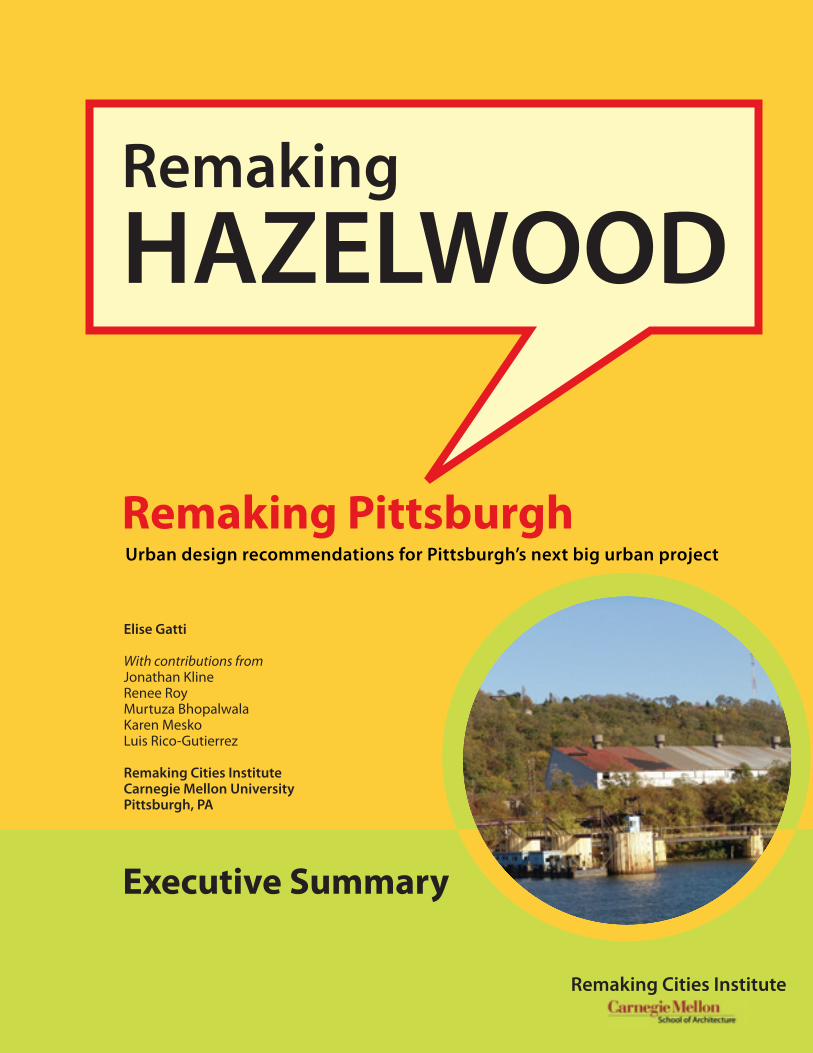
Remaking HAZELWOOD
Urban design recommendations for Pittsburgh’s next big urban project
Remaking Pittsburgh
Elise Gatti
With contributions fromJonathan KlineRenee RoyMurtuza BhopalwalaKaren MeskoLuis Rico-Gutierrez
Remaking Cities InstituteCarnegie Mellon UniversityPittsburgh, PA
Executive Summary

HAZELWOOD URBAN DESIGN RECOMMENDATIONS 1
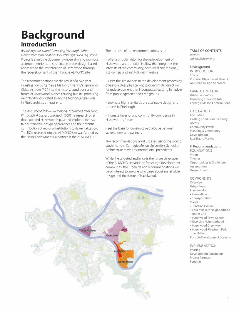
Remaking Hazelwood, Remaking Pittsburgh: Urban Design Recommendations for Pittsburgh’s Next Big Urban Project is a guiding document whose aim is to promote a comprehensive and sustainable urban design-based approach to the revitalization of Hazelwood through the redevelopment of the 178-acre ALMONO site.
The recommendations are the result of a two-year investigation by Carnegie Mellon University’s Remaking Cities Institute (RCI) into the history, conditions and future of Hazelwood, a once thriving but still promising neighborhood located along the Monongahela River in Pittsburgh’s southeast end.
The document follows Remaking Hazelwood, Remaking Pittsburgh: A Background Study (2007), a research brief that explored Hazelwood’s past and explored innova-tive sustainable design approaches and the potential contribution of regional institutions to its revitalization. The RCI’s research into the ALMONO site was funded by the Heinz Endowments, a partner in the ALMONO, LP.
The purpose of the recommendations is to:
• offer a singular vision for the redevelopment of Hazelwood and Junction Hollow that integrates the interests of the community, both local and regional, site owners and institutional investors
• assist the site owners in the development process by offering a clear physical and programmatic direction for redevelopment that incorporates existing initiatives from public agencies and civic groups
• promote high standards of sustainable design and process in Pittsburgh
• increase investor and community confidence in Hazelwood’ s future
• set the basis for constructive dialogue between stakeholders and partners
The recommendations are illustrated using the work of students from Carnegie Mellon University’s School of Architecture as well as international precedents.
While the targeted audience is the future developer of the ALMONO site and the Pittsburgh development community, the urban design recommendations will be of interest to anyone who cares about sustainable design and the future of Hazelwood.
TABLE OF CONTENTSPrefaceAcknowledgements
I BackgroundINTRODUCTION ScopePurpose, Objectives & BenefitsAn Urban Design Approach
CARNEGIE MELLONUrban LaboratoryRemaking Cities Institute Carnegie Mellon Contributions
HAZELWOODFocus AreaExisting Conditions & HistoryAccessCommunity ProfilePlanning & Community DevelopmentReal Estate Market
II RecommendationsFOUNDATIONSVisionThemesOpportunities & ChallengesAssumptionsGreen Urbanism
COMPONENTSOverview Urban FormFrameworks • Green-Blue • TransportationPlaces • Junction Hollow • Four Mile Run Neighborhood • Robot City• Hazelwood Town Center• Riverside Neighborhood• Hazelwood Greenway• Hazelwood Riverfront Park Legibility Possible Development Scenario
IMPLEMENTATION Phasing Development Constraints Project Partners Funding
BackgroundIntroduction
EXECUTIVE SUMMARY
2
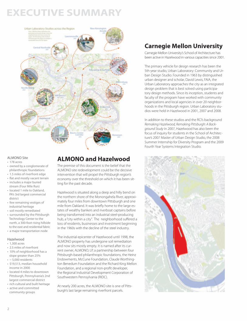
ALMONO Site • 178 acres• owned by a conglomerate of philanthropic foundations• 1.5 miles of riverfront edge• flat and mostly vacant terrain• includes a major buried stream (Four Mile Run)• located 1 mile to Oakland, PA’s 3rd largest commercial district• few remaining vestiges of industrial heritage• soil mostly remediated• surrounded by the Pittsburgh Technology Center to the north, a 300-foot rising hillside to the east and residential fabric • a major transportation node
Hazelwood• 1,300 acres• 2.5 miles of riverfront• 10% of neighborhood has a slope greater than 25%• ~ 5,000 residents• $19,513, median household income in 2000• located 4 miles to downtown Pittsburgh, Pennsylvania’s 2nd largest commercial district• rich cultural and built heritage• active and committed community groups
Carnegie Mellon University’s School of Architecture has been active in Hazelwood in various capacities since 2001.
The primary vehicle for design research has been the 5th-year studio, Urban Laboratory: Community and Ur-ban Design Studio. Founded in 1963 by distinguished urban designer and scholar, David Lewis, FAIA, the Urban Laboratory approaches the city as an integrated design problem that is best solved using participa-tory design methods. Since its inception, students and faculty of the program have worked with community organizations and local agencies in over 20 neighbor-hoods in the Pittsburgh region. Urban Laboratory stu-dios were held in Hazelwood in 2001, 2007 and 2008.
In addition to these studios and the RCI’s background Remaking Hazelwood, Remaking Pittsburgh: A Back-ground Study in 2007, Hazelwood has also been the focus of inquiry for students in the School of Architec-ture’s 2007 Master of Urban Design Studio, the 2008 Summer Internship for Diversity Program and the 2009 Fourth Year Systems Integration Studio.
Carnegie Mellon University
ALMONO and HazelwoodThe premise of this document is the belief that the ALMONO site redevelopment could be the decisive intervention that will propel the Pittsburgh region’s economy over the threshold on which it has been sit-ting for the past decade.
Hazelwood is situated along a deep and hilly bend on the northern shore of the Monongahela River, approxi-mately four miles from downtown Pittsburgh and one mile from Oakland. It was briefly home to the large es-tates of wealthy bankers and riverboat captains before being transformed into an industrial steel-producing hub, a “city within a city”. The neighborhood suffered a loss of residents, businesses and investment beginning in the 1960s with the decline of the steel industry.
The industrial epicenter of Hazelwood until 1998, the ALMONO property has undergone soil remediation and now sits mostly empty. It is named after its cur-rent owner, ALMONO, LP, a partnership between four Pittsburgh-based philanthropic foundations, the Heinz Endowments, McCune Foundation, Claude Worthing-ton Benedum Foundation and the Richard King Mellon Foundation, and a regional non-profit developer, the Regional Industrial Development Corporation of Southwestern Pennsylvania (RIDC).
At nearly 200 acres, the ALMONO site is one of Pitts-burgh’s last large remaining riverfront parcels.
HAZELWOOD URBAN DESIGN RECOMMENDATIONS 3
Urban Design ApproachAs a comprehensive and creative practice, urban design combines the social, cultural, ecological and economic dimensions of the built environment with issues of form, connectivity and aesthetics to create functional, equitable and attractive public places, land-scapes, streets, neighborhoods, districts and cities. An urban design approach to the redevelopment of the ALMONO site and Hazelwood can be used to: • support innovative, high-value added economic initiatives• facilitate stronger transportation, economic and cultural ties between Hazelwood and Oakland• renew and re-imagine connections within Hazelwood, particularly transportation infrastructure • create a new identity and sense of place for Hazelwood • support inclusiveness and participation • restore and sustain local ecological processes • celebrate and link Hazelwood and Pittsburgh’s natural, cultural and built heritage
VisionHazelwood is envisioned as a sustainable, mixed-use neighborhood whose varied and rich assets are activat-ed by thoughtful design and strong physical, cultural and economic connections to institutions of higher learning, industry and surrounding communities.
ThemesThe key underlying themes are: • Place-making• Accessibility and Connectivity• Conservation, Restoration, Sustainability• Culture, Built Environment, Nature (“3 Heritages”)• Water and Land• University-Community-Industry Collaboration• Diversity and Inclusivity
OpportunitiesUnderstanding the contextual opportunities and chal-lenges is critical to delivering a successful redevelop-ment vision. The project’s strengths, from an urban design perspective, include:• ALMONO, LP’s philanthropic and holistic vision • institutional interest from entities like Carnegie Mellon University’s Robotics Institute• strategic location, one mile to Oakland and four miles to downtown Pittsburgh• site assets, including its long riverfront, green hillside, walkable urban form, historic buildings and expansive views• a committed community in Hazelwood and a wealth of grass-roots civic and advocacy groups in Pittsburgh
ChallengesThe challenges to the proposed vision have been identified as:• a lack of connectivity and transportation choices for residents• degraded landscape functions, particularly the ripar-ian corridor and hydrological systems• privately-held land adjacent to the ALMONO site but within the scope of proposed major interventions
AssumptionsOur recommendations are premised on the following assumptions:• end of the Mon-Fayette toll expressway proposal• relocation of Metaltech, Inc. or the servicing of Met-altech by barge instead of riverfront rail• a Light Rail Transit system from Oakland through Junction Hollow to Hazelwood• closure of the Bellefield Steam Plant and addition of a new co-generation district energy plant in Hazelwood• assembly of private land within the scope of the plan
RecommendationsFoundations
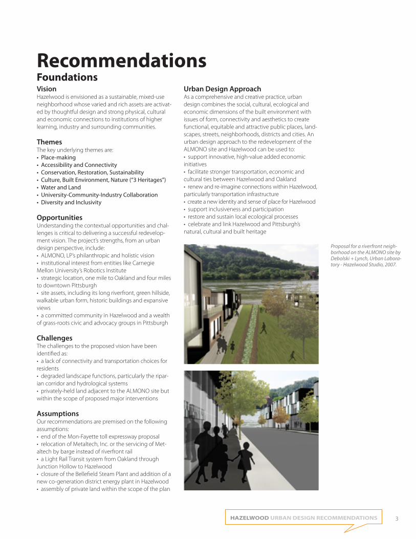
Proposal for a riverfront neigh-borhood on the ALMONO site by Debolski + Lynch, Urban Labora-tory - Hazelwood Studio, 2007.
EXECUTIVE SUMMARY
4
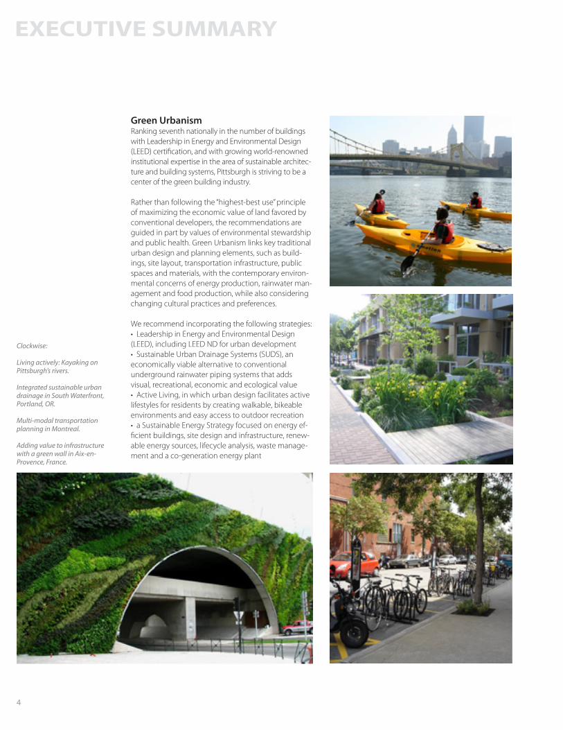
Green UrbanismRanking seventh nationally in the number of buildings with Leadership in Energy and Environmental Design (LEED) certification, and with growing world-renowned institutional expertise in the area of sustainable architec-ture and building systems, Pittsburgh is striving to be a center of the green building industry.
Rather than following the “highest-best use” principle of maximizing the economic value of land favored by conventional developers, the recommendations are guided in part by values of environmental stewardship and public health. Green Urbanism links key traditional urban design and planning elements, such as build-ings, site layout, transportation infrastructure, public spaces and materials, with the contemporary environ-mental concerns of energy production, rainwater man-agement and food production, while also considering changing cultural practices and preferences.
We recommend incorporating the following strategies:• Leadership in Energy and Environmental Design (LEED), including LEED ND for urban development• Sustainable Urban Drainage Systems (SUDS), an economically viable alternative to conventional underground rainwater piping systems that adds visual, recreational, economic and ecological value• Active Living, in which urban design facilitates active lifestyles for residents by creating walkable, bikeable environments and easy access to outdoor recreation• a Sustainable Energy Strategy focused on energy ef-ficient buildings, site design and infrastructure, renew-able energy sources, lifecycle analysis, waste manage-ment and a co-generation energy plant
Clockwise:
Living actively: Kayaking on Pittsburgh’s rivers.
Integrated sustainable urban drainage in South Waterfront, Portland, OR.
Multi-modal transportation planning in Montreal.
Adding value to infrastructure with a green wall in Aix-en-Provence, France.
HAZELWOOD URBAN DESIGN RECOMMENDATIONS 5
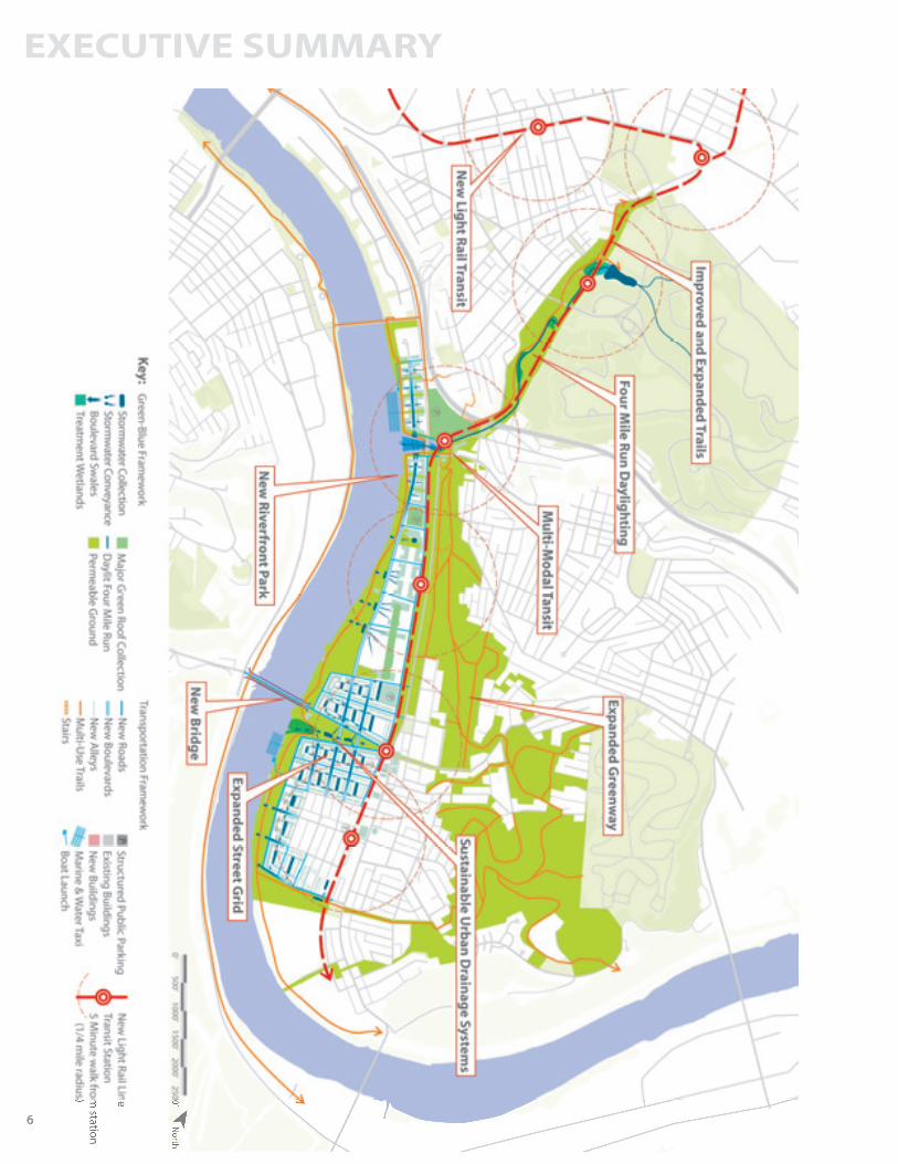
ComponentsOverviewThe urban design recommendations are organized around the basic components of urban design: • Urban Form (urban morphology and layout)• Frameworks (infrastructure)• Places (districts and zones)• Legibility (wayfinding, landmarks and views) • Possible Development and Program Scenario (uses)
Urban FormThe recommendations begin with a spatial redistribu-tion strategy for Hazelwood that focuses density and intensity of uses along major transportation routes and service districts along Second Avenue.
The strategy has several benefits, opening up new recre-ational spaces along Hazelwood’s steep slopes and sup-porting existing efforts to preserve Pittsburgh’s hillsides as a visual asset, while reinforcing existing and proposed commercial nodes in order to ensure greater viability.
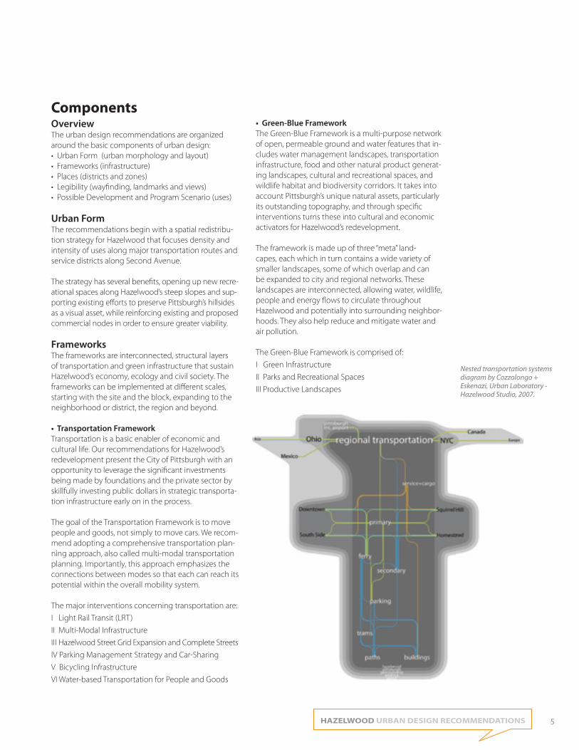
FrameworksThe frameworks are interconnected, structural layers of transportation and green infrastructure that sustain Hazelwood’s economy, ecology and civil society. The frameworks can be implemented at different scales, starting with the site and the block, expanding to the neighborhood or district, the region and beyond.
• Transportation FrameworkTransportation is a basic enabler of economic and cultural life. Our recommendations for Hazelwood’s redevelopment present the City of Pittsburgh with an opportunity to leverage the significant investments being made by foundations and the private sector by skillfully investing public dollars in strategic transporta-tion infrastructure early on in the process.
The goal of the Transportation Framework is to move people and goods, not simply to move cars. We recom-mend adopting a comprehensive transportation plan-ning approach, also called multi-modal transportation planning. Importantly, this approach emphasizes the connections between modes so that each can reach its potential within the overall mobility system.
The major interventions concerning transportation are:
I Light Rail Transit (LRT)
II Multi-Modal Infrastructure
III Hazelwood Street Grid Expansion and Complete Streets
IV Parking Management Strategy and Car-Sharing
V Bicycling Infrastructure
VI Water-based Transportation for People and Goods
• Green-Blue Framework The Green-Blue Framework is a multi-purpose network of open, permeable ground and water features that in-cludes water management landscapes, transportation infrastructure, food and other natural product generat-ing landscapes, cultural and recreational spaces, and wildlife habitat and biodiversity corridors. It takes into account Pittsburgh’s unique natural assets, particularly its outstanding topography, and through specific interventions turns these into cultural and economic activators for Hazelwood’s redevelopment.
The framework is made up of three “meta” land-capes, each which in turn contains a wide variety of smaller landscapes, some of which overlap and can be expanded to city and regional networks. These landscapes are interconnected, allowing water, wildlife, people and energy flows to circulate throughout Hazelwood and potentially into surrounding neighbor-hoods. They also help reduce and mitigate water and air pollution.
The Green-Blue Framework is comprised of:
I Green Infrastructure
II Parks and Recreational Spaces
III Productive Landscapes
Nested transportation systems diagram by Cozzolongo + Eskenazi, Urban Laboratory - Hazelwood Studio, 2007.
EXECUTIVE SUMMARY
6 6
HAZELWOOD URBAN DESIGN RECOMMENDATIONS 7
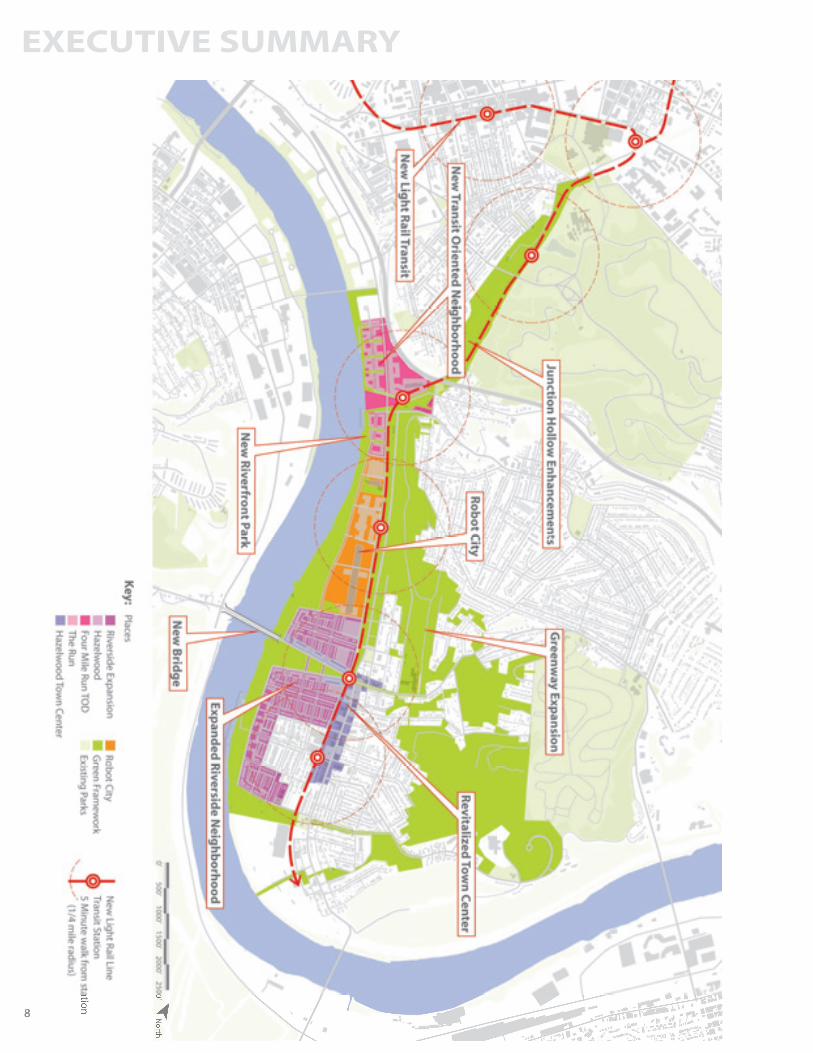
PlacesWithin the structuring transportation and open space frameworks are seven special environments, each with a unique program of uses and character. The Places were inspired by the existing context as well as the vi-sion for the ALMONO site. While they each stand alone, their programs and connections via the Frameworks allow for synergies between them.
• Junction HollowBordered by Carnegie Mellon University, South Oakland, Schenley Park and Hazelwood’s The Run Neighborhood, the mile-long Junction Hollow is the most direct route between Hazelwood and Oakland. It is managed by the Pittsburgh Parks Conservancy (PPC).
The recommendations for Junction Hollow are to enhance its recreational, ecological and connectivity potential with the following interventions:I Daylighting the Four Mile RunII LRT and Bikeway to OaklandIII New Sports FieldsIV PPC-Recommended Schenley Park ImprovementsV Innovative Research Grounds
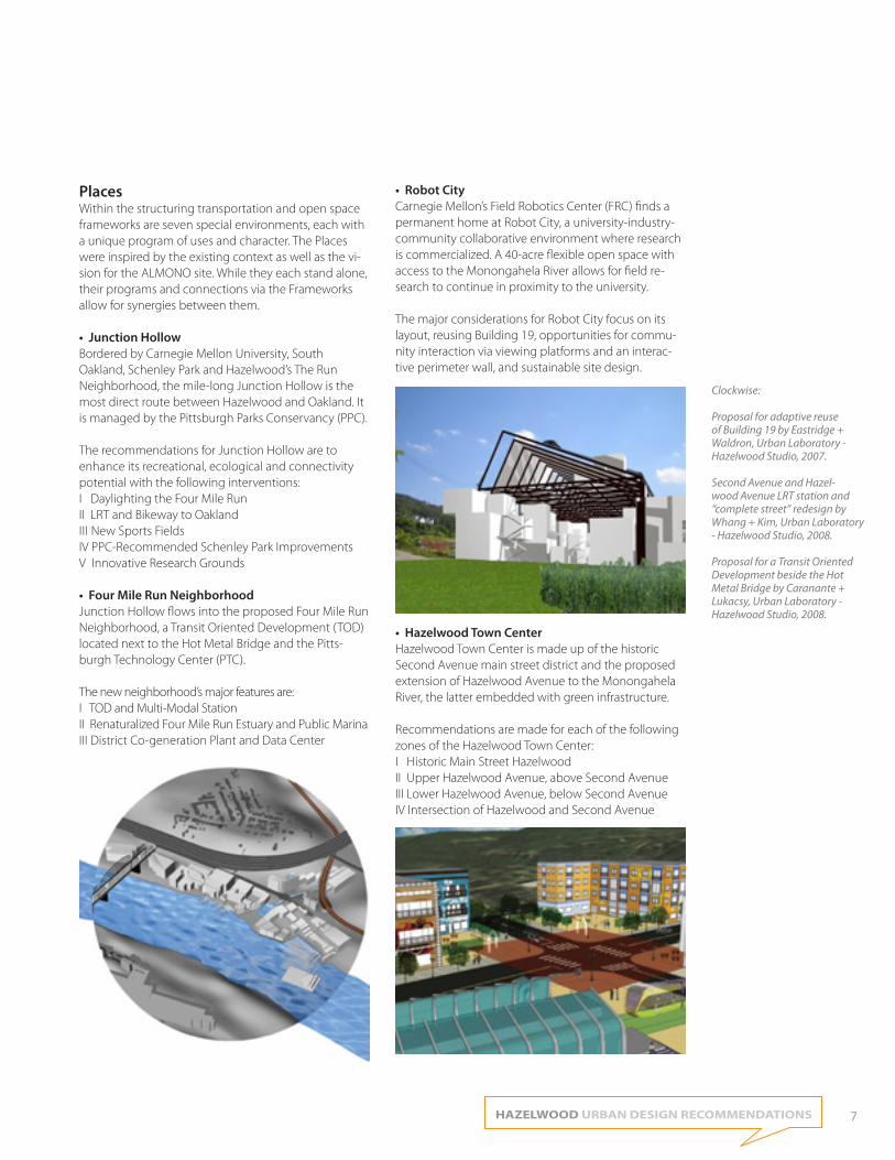
• Four Mile Run NeighborhoodJunction Hollow flows into the proposed Four Mile Run Neighborhood, a Transit Oriented Development (TOD) located next to the Hot Metal Bridge and the Pitts-burgh Technology Center (PTC). The new neighborhood’s major features are: I TOD and Multi-Modal StationII Renaturalized Four Mile Run Estuary and Public MarinaIII District Co-generation Plant and Data Center
• Robot CityCarnegie Mellon’s Field Robotics Center (FRC) finds a permanent home at Robot City, a university-industry-community collaborative environment where research is commercialized. A 40-acre flexible open space with access to the Monongahela River allows for field re-search to continue in proximity to the university.
The major considerations for Robot City focus on its layout, reusing Building 19, opportunities for commu-nity interaction via viewing platforms and an interac-tive perimeter wall, and sustainable site design.
• Hazelwood Town Center Hazelwood Town Center is made up of the historic Second Avenue main street district and the proposed extension of Hazelwood Avenue to the Monongahela River, the latter embedded with green infrastructure.
Recommendations are made for each of the following zones of the Hazelwood Town Center:I Historic Main Street HazelwoodII Upper Hazelwood Avenue, above Second AvenueIII Lower Hazelwood Avenue, below Second AvenueIV Intersection of Hazelwood and Second Avenue
Clockwise:
Proposal for adaptive reuse of Building 19 by Eastridge + Waldron, Urban Laboratory - Hazelwood Studio, 2007.
Second Avenue and Hazel-wood Avenue LRT station and “complete street” redesign by Whang + Kim, Urban Laboratory - Hazelwood Studio, 2008.
Proposal for a Transit Oriented Development beside the Hot Metal Bridge by Caranante + Lukacsy, Urban Laboratory - Hazelwood Studio, 2008.
EXECUTIVE SUMMARY
8 8
HAZELWOOD URBAN DESIGN RECOMMENDATIONS 9
• Riverside Neighborhood Riverside Neighborhood is seamlessly knitted into the existing residential fabric of Hazelwood. The proposal doubles the existing population base of Hazelwood, brings the neighborhood closer to the Monongahela River and introduces new housing types, including different options for senior and student housing, and riverboat living. Pocket parks and a live-work zone in the middle of Riverside increase the dynamism and livability of this new urban neighborhood.
Riverside Neighborhood recommendations focus on:I Peripheral DensityII Diversity of HousingIII Houseboat CommunityIV Neighborhood AmenitiesV Live-Work along Elizabeth Street
• Hazelwood Greenway The Hazelwood Greenway is a linear, four-season hillside recreational space and wildlife habitat offering spectacular views of Hazelwood and the Monongahela River corridor.
Specific suggestions include an expanded trail system for hiking and mountainbiking, a viewing platform, a wayfinding system, low-impact recreational infrastruc-ture, productive landscapes and connections to other city parks.
The major interventions are centered on:I Definable Edges and EntrancesII Greenway AmenitiesIII Connection to Existing Parks
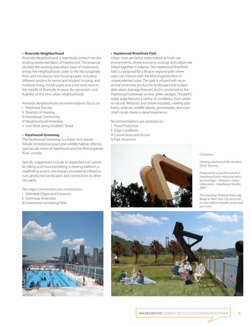
• Hazelwood Riverfront ParkUrban rivers are being rediscovered as multi-use environments, where economy, ecology and culture are linked together in balance. The Hazelwood Riverfront Park is a proposal for a 90-acre regional park where users can interact with the Monongahela River in unprecedented ways. The park is infused with recre-ational amenities, productive landscapes and sustain-able urban drainage features, and is connected to the Hazelwood Greenway via four green wedges. The park’s water edge features a variety of conditions, from urban to natural. Wetlands and stream estuaries, viewing plat-forms, wharves, wildlife islands, promenades, and even small canals create a varied experience.
Recommendations are centered on:I Flood Protection II Edge ConditionsIII Connections and AccessIV Park Amenities
Clockwise:
Viewing platform of the Aurland Fjord, Norway.
Proposal for a riverfront park in Hazelwood with industrial relics by Eastridge + Waldron, Urban Laboratory - Hazelwood Studio, 2007.
The traveling Floating Pool Lady Barge in New York City reconsid-ers the nature of public pools and our rivers.
EXECUTIVE SUMMARY
10
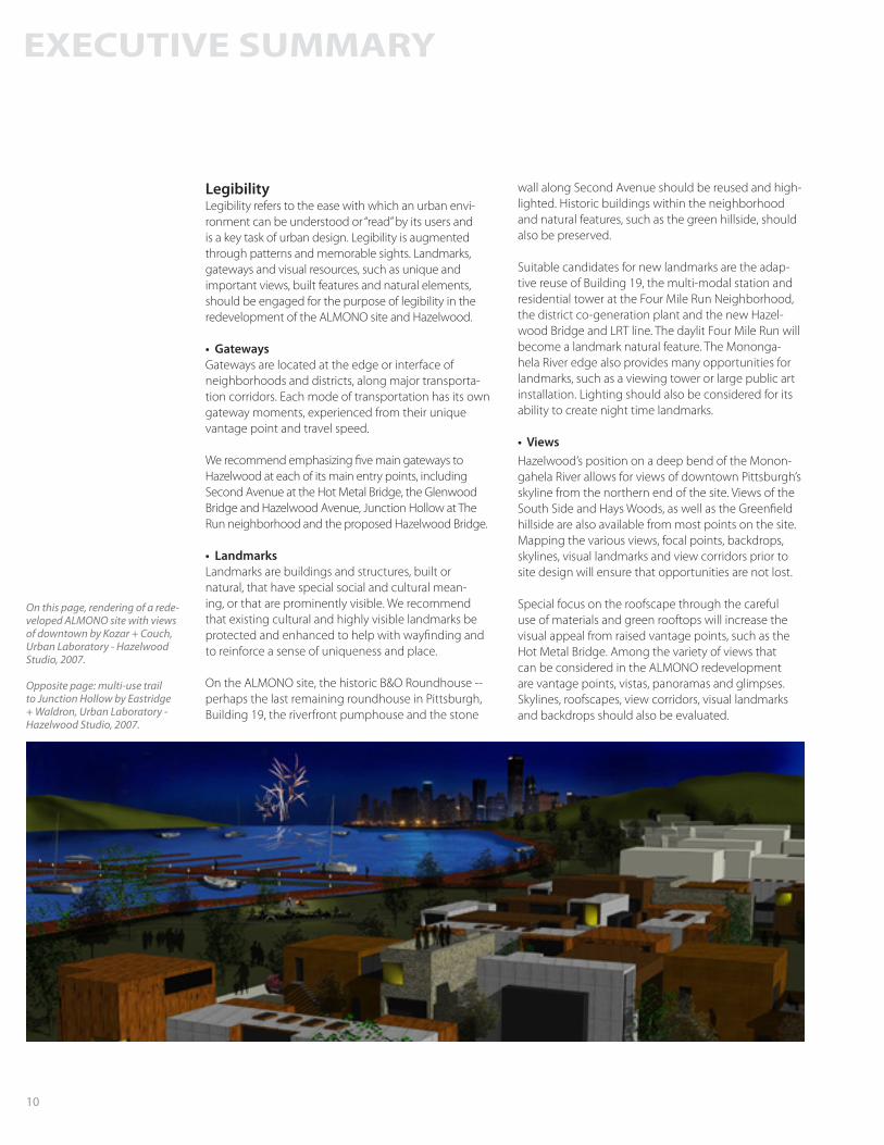
LegibilityLegibility refers to the ease with which an urban envi-ronment can be understood or “read” by its users and is a key task of urban design. Legibility is augmented through patterns and memorable sights. Landmarks, gateways and visual resources, such as unique and important views, built features and natural elements, should be engaged for the purpose of legibility in the redevelopment of the ALMONO site and Hazelwood.
• GatewaysGateways are located at the edge or interface of neighborhoods and districts, along major transporta-tion corridors. Each mode of transportation has its own gateway moments, experienced from their unique vantage point and travel speed.
We recommend emphasizing five main gateways to Hazelwood at each of its main entry points, including Second Avenue at the Hot Metal Bridge, the Glenwood Bridge and Hazelwood Avenue, Junction Hollow at The Run neighborhood and the proposed Hazelwood Bridge.
• LandmarksLandmarks are buildings and structures, built or natural, that have special social and cultural mean-ing, or that are prominently visible. We recommend that existing cultural and highly visible landmarks be protected and enhanced to help with wayfinding and to reinforce a sense of uniqueness and place.
On the ALMONO site, the historic B&O Roundhouse -- perhaps the last remaining roundhouse in Pittsburgh, Building 19, the riverfront pumphouse and the stone
wall along Second Avenue should be reused and high-lighted. Historic buildings within the neighborhood and natural features, such as the green hillside, should also be preserved.
Suitable candidates for new landmarks are the adap-tive reuse of Building 19, the multi-modal station and residential tower at the Four Mile Run Neighborhood, the district co-generation plant and the new Hazel-wood Bridge and LRT line. The daylit Four Mile Run will become a landmark natural feature. The Mononga-hela River edge also provides many opportunities for landmarks, such as a viewing tower or large public art installation. Lighting should also be considered for its ability to create night time landmarks.
• ViewsHazelwood’s position on a deep bend of the Monon-gahela River allows for views of downtown Pittsburgh’s skyline from the northern end of the site. Views of the South Side and Hays Woods, as well as the Greenfield hillside are also available from most points on the site. Mapping the various views, focal points, backdrops, skylines, visual landmarks and view corridors prior to site design will ensure that opportunities are not lost.
Special focus on the roofscape through the careful use of materials and green rooftops will increase the visual appeal from raised vantage points, such as the Hot Metal Bridge. Among the variety of views that can be considered in the ALMONO redevelopment are vantage points, vistas, panoramas and glimpses. Skylines, roofscapes, view corridors, visual landmarks and backdrops should also be evaluated.
On this page, rendering of a rede-veloped ALMONO site with views of downtown by Kozar + Couch, Urban Laboratory - Hazelwood Studio, 2007.
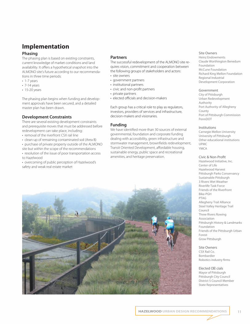
Opposite page: multi-use trail to Junction Hollow by Eastridge + Waldron, Urban Laboratory - Hazelwood Studio, 2007.
HAZELWOOD URBAN DESIGN RECOMMENDATIONS 11
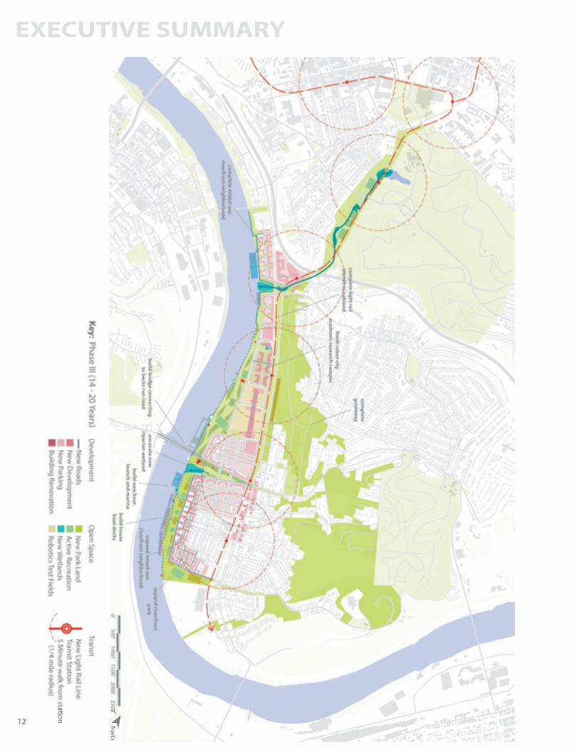
ImplementationPhasingThe phasing plan is based on existing constraints, current knowledge of market conditions and land availability. It offers a hypothetical snapshot into the ALMONO site’s future according to our recommenda-tions in three time periods: • 1-7 years• 7-14 years • 15-20 years
The phasing plan begins when funding and develop-ment approvals have been secured, and a detailed master plan has been drawn.
Development ConstraintsThere are several existing development constraints and prerequisite moves that must be addressed before redevelopment can take place, including: • removal of the riverfront CSX rail line • clean-up of remaining contaminated soil (Area B)• purchase of private property outside of the ALMONO site but within the scope of the recommendations• resolution of the issue of poor transportation access to Hazelwood• overcoming of public perception of Hazelwood’s safety and weak real estate market
PartnersThe successful redevelopment of the ALMONO site re-quires vision, commitment and cooperation between the following groups of stakeholders and actors: • site owners• government partners• institutional partners• civic and non-profit partners• private partners• elected officials and decision-makers
Each group has a critical role to play as regulators, investors, providers of services and infrastructure, decision-makers and visionaries.
FundingWe have identified more than 30 sources of external governmental, foundation and corporate funding dealing with accessibility, green infrastructure and stormwater management, brownfields redevelopment, Transit Oriented Development, affordable housing, sustainable energy, public space and recreational amenities, and heritage preservation.
Site OwnersHeinz EndowmentsClaude Worthington Benedum FoundationMcCune FoundationRichard King Mellon FoundationRegional Industrial Development Corporation
Government City of PittsburghUrban Redevelopment AuthorityPort Authority of Allegheny County Port of Pittsburgh CommissionPennDOT
InstitutionsCarnegie Mellon University University of Pittsburgh Other educational institutionsUPMCYMCA
Civic & Non-ProfitHazelwood Initiative, Inc.Center of LifeHazelwood HarvestPittsburgh Parks ConservancySustainable Pittsburgh3 Rivers Wet WeatherRiverlife Task ForceFriends of the RiverfrontBike-PGH PTAGAllegheny Trail AllianceSteel Valley Heritage Trail CouncilThree Rivers Rowing AssociationPittsburgh History & Landmarks FoundationFriends of the Pittsburgh Urban ForestGrow Pittsburgh
Site OwnersCSX Rail Co.BombardierRobotics industry firms
Elected OfficialsMayor of PittsburghPittsburgh City CouncilDistrict 5 Council MemberState Representatives
EXECUTIVE SUMMARY
12 12


EXECUTIVE SUMMARY
14
To purchase a hard copy of the executive summary or the full report, please visit: www.lulu.com.
Digital copies can be obtained from the RCI website: www.cmu.edu/rci.
Remaking Cities InstituteCarnegie Mellon UniversityCollege of Fine Arts 201 Pittsburgh, PA 15213 USA
Copyright © September 2009