Embed Size (px)
Citation preview

1
Religion, Land and Politics:
Shrines and Literacy in Punjab
Adeel Malik
Department of International Development & Oxford Centre for Islamic Studies
University of Oxford [email protected]
Rinchan Ali Mirza Faculty of History
University of Oxford [email protected]
A B S T R A C T
This paper empirically examines the relationship between religious shrines and development. Compiling a unique database covering the universe of shrines across Pakistani Punjab, we explore whether the presence of holy Muslim shrines helps to explain regional variation in literacy rates. Our results demonstrate a non-linear impact of shrines per capita: shrines situated in regions closer to the river have a differential impact on literacy than those situated afar. Specifically, greater concentration of shrines in riverine regions tends to adversely affect literacy rates. We attribute this to the confluence of three resources—religion, land and politics—that together constitute a powerful structural inequality with potentially adverse consequences for development. Evidence suggests that the negative impact of riverine shrines on literacy is primarily mediated through their entry into politics. Probing the determinants of political selection, we demonstrate that shrines considered important in the colonial era were more likely to select into politics in post-partition Punjab.
JEL Codes: I25, N55, Z12, O15
Acknowledgements. We are indebted to: noted literary critic, Fateh Mohammad Malik, for providing the initial intellectual inspiration for this project; David Gilmartin for his guidance; Sohail Chaudhry for administrative support; and Rafay Khan for excellent research assistance. For their helpful feedback, we are also thankful to Francis Robinson, Mohammad Talib, Farhan Nizami, and seminar participants at the Universities of Oxford, Cambridge and International Food Policy Research Institute (IFPRI), Washington, D.C. All errors and omissions are the sole responsibility of authors.
This draft version: 05 August 2014

2
I. Introduction
It is a well-received wisdom that the wealth of a nation is determined, not just by its physical, but also human, capital. In fact, long-term prosperity is unthinkable without an educated population. A large body of theoretical and empirical research has examined the role of human capital in advancing development (Klenow and Rodriguez-Clare 2005; Glaeser et al. 2004; Gennaioli et al. 2013). This begs the question: What explains the substantial variation in literacy rates across and within developing countries? And, why some countries are condemned to persistently low levels of literacy? In thinking about constraints to human capital development, the earlier literature emphasized largely proximate explanations focusing on the role of expenditures, inputs and adverse resource endowments. But, as the growing literature on political economy argues, determinants of development are often deep, rooted in the underlying structure of economic and political inequality (Acemoglu and Robinson 2012). This applies equally to education: schooling differences across countries are grounded in history and political economy (Gallego 2010; Acemoglu et al. 2014).
Taking a cue from this literature, we investigate how the initial configuration of economic, political and religious power might have shaped patterns of literacy across Pakistani Punjab. Specifically, we examine the role played by the confluence of land inequality, concentration of religious shrines and political power. Our main argument is that religious power, measured by the concentration of shrines, only matters for literacy when these shrines own more land and exercise greater political power manifested through direct electoral participation. We argue that this interplay between religion, land and politics—best represented through the influence of riverine shrines—constitutes a powerful structural inequality with potentially adverse consequences for development.
Why should religious power matter for development outcomes? The shrines of great sufi mystics, who played a leading role in spreading Islam, occupy a prominent place in the religious, cultural and political life of South Asia. Shrines of prominent mystics have traditionally acted as the “symbolic cultural outposts of the power of Islam and the Muslim state” (Gilmartin 1988). They serve as locations of annual religious festivals (urs) that attract thousands of devotees from regions both neighbouring and distant, and receive public offerings that sometimes run into millions of Rupees. Activities organized around these shrines afford opportunities for both religious and economic exchange. Major religious festivals often coincide with key agricultural seasons, and an elaborate bazaar economy thrives at the footsteps of these shrines.
Shrines are immersed not just in the local rural economy; they also act as important nodes of political power. They are often structurally positioned within the prevailing economic and political systems. Shrine caretakers (sajjāda nishīns)1 command tremendous respect and influence among their vast network of devotees. The unquestionable allegiance of their followers converts them into important intermediaries between, not just God and man, but also between the state and its subjects. This power of intermediation is particularly important in peripheral regions, where, due to weak power of the central state, rulers had greater dependence on local elites for political support. Shrine elites have traditionally acted as brokers of centralized power throughout history—from Mughal rule and the Sikh interregnum to colonial India and post-partition Pakistan. 1 Literally: “He who sits on the prayer carpet”. Sajjada Nishins are often hereditary figures with some lineage to the saint originally associated with the shrine.
3
While the state, its functionaries and non-religious local elites seek legitimacy from these shrine families, the guardians of these shrines, in turn, use this dependence to access state patronage and other privileges that help them to consolidate their power. In a sense, the power and influence enjoyed by shrine families resembled those of local chiefs and notables of Punjab. In line with Peter Brown’s description of Christian saints as “patrons par excellence”, the shrine guardians serve as a crucial link between the rural populace and the state, binding the pīrs (Sufi saints centred at shrines) and their followers, known as murids, in a patron-client relationship. Over time, continued state patronage has made prominent shrine families into large landowners. In many areas of Punjab they are both “spiritual and feudal masters”, appropriately termed as pīr-zamindārs.2
This linkage between piety and privilege has profound implications for prosperity. The power of the pīr is reinforced in a hierarchical society that is based on loyalty, obedience and superstition. The pīr often acts as the overlord of an exploitative structure, where any material and human uplift is viewed as a threat. As Sir Malcolm Darling presciently observed in his seminal work, The Punjab Peasant:
“Worst of all, both landlord and pir are instinctively opposed to the two movements from the which the ordinary cultivator has most to hope. Neither education nor cooperation has their sympathy, for both strike at the regime which it is their one object to maintain” (Darling 1928: 100).
A more recent assessment on Pakistan by Anatol Lieven echoes the same concern: “in practice the pirs and their families cannot genuinely advance either local education or local democracy, as this would strike directly at the cultural and social bases of their own power”.3 In fact, the literature is replete with references to the pīr’s resistance to educational progress. To famous historian, K. K. Aziz, this is unsurprising. “How could a pīr”, he asks, “countenance any prospect for the education of the masses when his supremacy, status and income depended on their ignorance and superstition?” (Aziz 2001:27). He goes on to argue:
“The pīr-zamindar, in order to protect his supremacy against any plebeian questioning and to retain intact the loyalty of his followers, discourages the spread of education in his area. Even the most superficial and inferior kind of public instruction and the ensuing rents in the veil of ignorance might push some of his spiritual slaves out of their prison of superstition and unthinking obedience. Education is a plague which he does not want his flock to catch” (Aziz 2001:159).
While prior literature has commented on the possible impact of shrines on local development, this paper conducts a first systematic enquiry into the subject. We empirically examine whether the presence of shrines explains regional variation in literacy rates across Punjab. Our focus on Punjab is guided not just by a pragmatic concern—the availability of data on literacy by tehsils—but the central role of Punjab in the transmission of Islam’s mystical influence in South Asia. Interspersed between Central Asia and the heartlands of India, Punjab is home to some of the oldest sufi orders of India. It has a rich tradition of saintly presence: tombs of famous saints have traditionally offered important meeting points for religious, economic and political exchange. Shrines are a constitutive element of local political economy. In fact, it is impossible to 2 Can be roughly described as religious (sufi) landlords. Terminology was originally deployed by Aziz (2001). 3 Lieven (2011: p. 138).

4
map Punjab’s rural power structure without accounting for the interaction between sufi saints and state power.
To explore the impact of shrines on literacy, we compile a unique database that covers the universe of shrines across Punjab and maps their political influence over time. To our knowledge, this is the first such detailed compilation of shrine-related records in Punjab. We then construct an indicator, shrines per capita, that is used in regression models of literacy rate. Since shrines vary in both size and significance, we do not expect a simple association between the concentration of shrines and literacy. Instead, we are interested in the interplay between religion, land and politics. A key empirical claim of this paper is that such a nexus is best captured through the effect of riverine shrines whose political economy, we argue, is radically different from shrines situated farther from the river.
Our empirical results lend support to this. A greater concentration of shrines in riverine tehsils is associated with systematically lower literacy rates compared to that in tehsils more distant from the river. The results are obtained after controlling for a variety of literacy determinants and geographic controls. We further demonstrate that the negative impact of riverine shrines is mediated through the selection of such shrines into politics. We interpret this evidence to suggest that shrines influence literacy largely through their bearing on local political economy. Finally, we also investigate the determinants of political selection. We find that the religious and material power exercised through shrines is historically embedded: regions where a greater number of shrines were mentioned in British colonial documents are also more likely to have politically influential shrines today. While past studies have focused on singular dimensions of political economy, this paper underscores the role of structural inequality, defined by the interplay between religion, land and politics. Furthermore, besides establishing persistence of religious power, it provides a possible mechanism for this persistence: the selection of shrine guardians into politics.
Apart from enriching the existing literature on the determinants of literacy, our study feeds into three additional strands of literature. It makes a direct contribution to an influential literature at the intersection of Islamic studies and history that throws light on the spiritual and political ecosystem associated with shrines. Studies in this tradition have considered the impact of shrines on nationalism (Gilmartin 1979, 1988), systems of political control (Ansari 1992; Aziz 2001) and moral authority (Gilmartin 1984, Metcalf 1984). None of this work has broached the development dimension in much detail. Our paper makes a first systematic effort at probing the relationship between shrines and development.
Secondly, this study contributes to a smaller, more localized literature, focusing on explaining regional variation in Punjab’s development outcomes (Cheema et al. 2008; BNU 2012). While this empirical literature is largely concerned with proximate explanations, this paper lays emphasis on relatively deep determinants of literacy. Finally, this study adds to the growing discourse on religion and development (Barro 2003; Guiso et al. 2003; Noland 2005)4. Reviewing this expanding field, Iyer (2008) argues that: “The role of religion in economic development warrants a nuanced perspective that integrates economic theory with an understanding of socio-political structures”. Our emphasis on historically embedded structural inequality precisely underscores that spirit. 4 This is a selected list of references in an expanding field. For a detailed introduction into the literature, see Iyer (2008).
5
The remainder of this paper is structured as follows. Section II develops a broader historical narrative on shrines and development. Section III describes the data and sets out the paper’s empirical strategy. The main empirical results are discussed in section IV. Section V conducts a battery of robustness tests and section VI takes up the issue of political selection. Finally, section VII concludes.
II. Shrines and development: Historical Background
This section develops a broader historical narrative on shrines and development. We argue that this relationship is primarily shaped by local political economy. Although the influence of shrines is built on “sacred genealogies”, their material power is shaped by the negotiation between the sacred and the secular or, what David Gilmartin describes as, the interface between the “universal and the particular”. Given this emphasis on political economy, our focus is on the “this-worldly” influence of shrines.5 The ensuing discussion extensively relies on detailed archival evidence from colonial District Gazetteers and various historical monographs.6
The discussion below is organized around three inter-connected themes: dependence, privilege and persistence. Central to the intermediary role of shrine is the dialectic of dependence. Both the state and the subject are dependent, in their respective constituencies, on shrine guardians. Such dependence translates into material privilege that is consolidated through politics. A recurring theme in this discourse is one of persistence: the power of notable shrines is historically embedded and has persisted through time.
Dependence
Since times immemorial shrines have played an important role in the religious culture and political economy of Punjab. The great sufi mystics from Baba Fariduddin Ganj-i-Shakar of Pakpattan and Shaikh Bahawal Haq Zakariyya of Multan to Sayyid Jalaluddin Bokhari of Uch have dominated the popular imaginary of Punjab. Sufi saints served as important conduits of religious transmission. As Gilmartin notes, “many rural Punjabi tribes have traced their conversion [to Islam] to these medieval saints”7. The physically imposing shrines dotted along Punjab are not only architectural masterpieces but also shape the lived reality of citizens. The tombs of saints are revered for their inclusive approach and social services. People from all walks of life, irrespective of caste, creed or religion, regularly pay their homage to these holy sites. For the seeker the shrine provides not just a sight of spiritual devotion but also a temporary refuge from a precarious existence. It provides food to the poor, house to the homeless and traveller, medicine to the ill, and solace to the depressed.
This popular culture of respect and reverence is solidified through a rich tradition of annual festivals and fairs, where pilgrims congregate, markets are formed and networks are consolidated. Such movement of people and resources has continued for generations. Attendance at these festivals (urs) can sometimes run into hundreds of thousands. Even in colonial times some shrines received 50,000 people or more on an annual urs (see Appendix 1). These festivals have “marked many shrines as important centres of rural economic and political
5 Inspired by Francis Robinson’s distinction between “this-worldly and other-worldly”. 6 We rely, in particular, on David Gilmartin’s magnum opus, Empire and Islam, and Malcolm Darling’s Punjab Peasant. 7 Gilmartin (1988: p. 40).

6
power”.8 Central to this is the distributive function of shrines, whereby offerings of land, livestock and produce are collected as alms and partially redistributed amongst the local population.
Importantly, shrines are embedded, not just in the local welfare economy, but are also sometimes part of extractive institutions. Aided by superstition, ill-health and economic deprivation many shrine subjects are tied in a vicious cycle of dependence. Numerous accounts of this can be found in Darling (1928). Speaking of the well-known connection between shrines and health, Darling notes that “superstitions are rife and the evil eye is universally dreaded. Since medicine has no power over the latter, medical aid is little sought, and those who are ill prefer to pay their hereditary pīr large sums in order to invoke his supernatural powers”.9 Being more prone to superstition and illiteracy, women are particularly attracted to shrines. Given their greater concern for family problems in matters of income, birth and death, women are more drawn to the spiritual support system offered by shrines.10
For men shrines offer a domain of both allegiance and obedience. In the true spirit of Taqlid, murids uphold the “unquestioned authority” of the sajjāda nishīns. The world of shrines is one of tightly bound networks of devotees that sometimes extend to neighbouring villages, towns, districts and even provinces.11 As suggested below, such undisputed loyalty of devotees serves as a crucial political resource that paves the way for a shrine family’s entry into politics. Guardians of influential shrines, much like tribal chieftains, routinely deploy the tools of patronage and control. Their power blends with local structures of control that are adept at enframing captive subjects. Recalling a description of the Alipur tehsil of Muzaffargarh, Darling (1928) notes how “every five miles or so is the house of a tribal or religious leader, who maintains a band of retainers to enforce his influence on his poorer neighbours.”
This can reduce the life of the poor to one of virtual serfdom. The ordinary cultivator of Punjab, we learn, is “triply bound” by three scourges: the landlord, pir, and kirar (money lender). Each, according to Darling, “contributes to their fetter”.12 On another instance, he observes: “The poor man pays blackmail for his cattle to these local chieftains and for his soul to his pir, who may or may not live in his neighbourhood, but visits his followers to receive his dues”.13 Reinforcing this message, Aziz (2001) argues that, “as lords of the shrine… they commanded both the body and the soul of the poor villager”.14 Even females are vulnerable to exploitation. Instances of sexual harassment and rape are a common occurrence, and routinely become the subject of press reports and literary caricatures.
This regime of coercion is facilitated through control of resources. The pīrs are often caricatured as leading a rich and extravagant life. In one commentary, Albinia (2008), they are described as owning “expensive Italian clothes, fleets of Mercedes cars and credit cards from American
8 Gilmartin (1988: p. 43). 9 The account pertains to Attock District (Darling 1928: 107). 10 Popular accounts, journalistic as well as literary, and District Gazetteers are often replete with references to the greater pull of shrines for females. As Aziz (2001) argues, this is also true for urban regions: “The women of the urban middle class have exactly the same mentality and attitude towards religion and family problems as their rustic sisters” (p. 129). For the female world of shrines, see Jeffrey (1979). 11 Many pirs of South Punjab have a wide constituency of followers in Sind province as well. 12 Darling (1928: p. 101). 13 Darling (1928: p. 99). 14 Aziz (2001: p. 31).

7
Express”. Donations from urs15 are a key source. “A good urs”, Albinia notes, “can bring in 30 lakh rupees”. But their real power is derived through state patronage.
Privilege
In their search for legitimacy, local intermediation and “peace in the countryside”, rulers have often turned to the pīrs. Neither Mughal or Sikh nor the British could have ruled without their administrative support. With dependence comes privilege. The Sikhs and Mughals rewarded the loyalty of pīrs through land grants, a practice that continued in British rule and complemented with other forms of appeasement, such as honours and appointments. Given “their hereditary bases of power” the pīrs resembled tribal leaders “who were readily susceptible to the common forms of state political control”.16 As a class the pīrs of Punjab are known for their opportunism and political expediency. As defenders of status-quo, they have always supported men in power.
The British found in them ready allies. The leading pīr families supported the British in overthrowing Sikh rule and quelling the 1857 uprising in Punjab. Later, in early twentieth century, they conveniently distanced themselves from the anti-British Khilafat Movement, a precursor to the Indian independence movement.17 They aided the colonial administration in its War effort, contributing both men and resources. Such services were amply rewarded. Instances of colonial patronage to shrine guardians are extensively documented in the historical literature. The 1904 Gazetteer of the Bahawalpur State, for example, contains several records of landed estates (jagirs) and wells being awarded to pīrs.18
Shrine caretakers in Multan, Montgommery, Muzaffargarh, and Dera Ghazi Khan, among others, were given jagirs (grants in perpetuity). Supplementary grants were offered in the form of revenue free gardens, orchids and vegetable farms. When the crown wasteland was brought under canal irrigation, pīrs were given preferential access to colony land. Occasional references to these can be found in the historical literature. The pīr of a “powerful shrine in Attock District”, for example, “was given a personal landed gentry grant of ten rectangles in 1916, along with the lease of 15,000 acres of rakh land in his home district”.19 In Multan 19,751 acres of land was reserved for religious shrines, with 99% of these grants allocated to Muslim shrines.20 Other prominent shrines that received land grants included: Sultan Bahu and Uch Gul Imam Shah from Jhang; Shergarh and Pakpattan Sharif from Montgomery District; Shah Gardez, Musa Pak Shahid and Shaikh Kabir Qureshi from Multan; and Dera Din Panah from Muzaffargarh District.21 Several other shrines received maintenance grants and life muafis (revenue-free assignments). These included the shrine of Bhai Pheru and Mohammad Ghaus in Montgomery District. Life
15 As defined before, urs refers to the annual religious festival. 16 Gilmartin (1979: p. 488). 17 The Khilafat Movement was a broader protest, led mainly by the Muslims of India but also supported by Gandhi, against the breakup of Ottoman Caliphate. 18 Some details are as follows: The sajjada nashin of the Salih Muhammad Ujjan shrine in the Sadiqabad tehsil enjoyed an inam of 500 bighas of land from the state; the sajjada nashins of the Jetha-Bhutta shrine in Khanpur tehsil were assigned 500 bighas of land under the pretext of tel charag; the mutawalli of the Bhindwala Sahib shrine enjoyed an inam of 1.5 wells from the state authorities; the sajjada nashins of the Chachran Sharif shrine were granted the village of Waghuan in jagir which yielded an income of over Rs.20,000 annually. 19 Ali (1988: p. 106) 20 49 grants were made to Muslim shrines; only 10 were reserved for Hindu shrines. See, Gazetteer of the Multan District, 1923-24. 21 These selected land grants are noted in footnote 111 in Ali (1988: p. 106).
8
muafis were also assigned to shrines in Mianpur, Ghaunspur and Baghdad in Khanewal District.22
If the recipients were incapable, due to death or indebtedness, of managing their estates, their land were temporarily taken over by the state under the Court of Wards, restored to a profitable condition and subsequently returned to the awardee.23 Leading religious families who benefited from this facility included the Pīr of Makhad (Attock), Makhdoom of Shah Jewana (Jhang) and Syeds of Jalalpur Pirwala and Musa Pak Shahid (Multan).24 The former held, in proprietary rights, more than 34 thousand acres of agricultural land—see Table A2 (Additional Material). Leading pīr families were also incorporated into officialdom through appointments in provincial darbars, legislative councils, district boards and assemblies. 25 Others became Honorary Magistrates, Extra Assistant Commissioners and revenue collectors (zaildars). Recognizing the de facto power of local chiefs, the zaildari system selected men of influence as tax collectors. In many regions, prominent shrine families were natural contenders for this role. Table A1 (Additional Material) provides a selected list of such appointments from noted religious families (shrine caretakers in Karor Lal Isan, Shah Jewana, Alipur and Shahpur, among others, were appointed as zaildars). The access of shrine families to high office and valuable economic resources was significant in that it prepared them for a subsequent role in politics.
Persistence
When the British opened the political arena the pīrs, as spiritual and feudal lords, were natural contenders for power. They enjoyed access to both divine and political favour. The combination of religious and landed power, in particular, is a vital political asset in a milieu where, in the words of Anatol Lieven, “it is not wealth alone, but wealth plus either kinship or spiritual prestige, or both, that gives political power”.26 A shrine, in this regard, provides an ideal platform:
“Medium-size shrine makes him a small landowner and a local squire. The big shrine gives him an entrée into the zamindar club and makes a magnate of him. A leading shrine is a gold mine, which catapults him into the aristocratic category and brings him riches large enough to...enter politics directly at the highest level” Aziz (2001: 109).
There is a long-standing connection between pīrs and politics. In the 1920 and 1946 provincial elections roughly 19 percent of total rural Muslim constituencies were represented by pīrs.27 When an alliance of Punjab’s landed aristocracy was formed under the banner of Unionist Party the pīrs became its core members. The 1937 and 1946 elections in British India saw many prominent religious families from Punjab taking part in them. When the demand for Pakistan 22 Settlement Reports for Montgomery and Khanewal provide more precise information on these assignments. 23 In the event of death the state took responsibility for education of the young ward. Appreciating the education arrangements for the young son of a shrine guardian, the Deputy Commissioner noted that, “He promises to become an enlightened Sajjada Nashin as well as an intelligent zamindar”. The Court of Wards thus preserved the union between religious and dominant landed classes. See Report on Final Settlement of the Jhang District. 24 The estate of Makhdum Abdul Sattar Shah of Bilot Sharif in Dera Ismail Khan was also taken over under Court of Wards. Although, presently in Khyber-Pakhtoonwa Province, the shrine still commands a significant following among the shias of Pakki Shah Mardan in Mianwali, Punjab. 25 The guardian of the shrine of great sufi mystic, Baba Fariduddin Ganj-i-Shakkar was a leading provincial darbari in the colonial administration. Pir Mohammad Hussain of shergarh, Dipalpur tehsil, was also a Divisional Darbari. See Gilmartin (1979) for more examples. 26 Lieven (2011: p. 137). 27 See Aziz (2001: p. 39). The ratio for 1946 elections was calculated by authors.
9
gained strength, religious families readily joined the ranks of Muslim League and “played a decisive role in mobilizing support for Pakistan”.28 Whether military or civilian rule, sajjāda nishīns have been a permanent fixture of politics in post-independence Pakistan.29 Although the country’s first military ruler, Ayub Khan, attempted to exert greater control over shrine affairs, political pragmatism demanded a more lenient approach towards influential shrines whose support, like any past ruler, was crucial for him.30
From Zulfiqar Ali Bhutto to Nawaz Sharif, political governments have come and gone but the sun has never set on the political power of pīrs. They are an omnipresent reality in every political dispensation, whether a political party is ideologically on the left or right or whether a military ruler supported “Islamization” or “enlightened moderation”. While a noted protagonist of Islamization, General Zia-ul-Haq reached out to noted shrine families and inducted them into his Majlis-e-shura (consultative assembly). Some of the same pīrs joined General Pervez Musharraf’s cabinet two decades later, this time for undoing Zia’s legacy.31 The pīrs truly transcend traditional party lines. They are adept at shifting political loyalties, which partly explains the persistence of priestly power in politics.
Another reason why the pīr’s power easily translates into political dynasties is the instrument of hereditary succession, which spreads religious power across several generations. Table 1 provides a snapshot of the persistence of leading pīr families in politics. Although just a selective representation, Table 1 displays the remarkable overlap between spiritual and political dynasties, with some shrine families preserving their political turf since the pre-independence period. In the 2013 National Assembly there are some 43 sajjāda nishīns, which is equivalent to 16% of the house—a figure not miles away from their representation in the 1920 provincial assembly in British India.
The lure of spiritual network is especially powerful in constituencies where political parties are weakly penetrated and dependent on local notables. The blessing of a pīr is deemed critical here for winning an election, since it can complement party vote bank. With their army of obedient murids, the pīrs have a stable constituency of followers—a captive vote bank of sorts—that makes them electable even in an uncertain political game. Some constituencies are completely dominated by religious families. Political parties are pretty much dependent here on pīr’s support. In the 2013 elections all the top four candidates for NA-194, Rahimyar Khan III, belonged to prominent religious families; the winner was an independent candidate.32 In other constituencies where the pīr’s network alone is insufficient for electoral victory he is dependent on party support. This creates a relationship of mutual dependence between parties and pīrs. The influence of some pīrs stretches beyond their own constituency, which makes them a vital
28 Gilmartin (1979). 29 Tombs of prominent saints are also regularly frequented by top government functionaries and political leaders. 30 Ayub Khan tried to regulate the finance, upkeep and activities of shrines through the establishment of a Waqf Department under a separate ordinance. However, it is worth mentioning that Khan was himself a self-professed murid of the Pir of Dewal Sharif. See Ewing (1983). 31 General Pervez Musharraf patronized the notion of “enlightened moderation” to counter religious extremism. 32 The four candidates were: Makhdoom Khusro Bakhtiar (Independent), Makhdoom Shahab ud Din (PPP), Makhdoom Moin ud Din Hashmi (PML-N), and Makhdoom Imad ud Din Hashmi (PTI). All advocates for political change, including the PTI, had to field their candidate from a religious party.
10
asset for building and sustaining regional political alliances. This dense network of power and privilege is further consolidated through nuptial bonds with other landed and pīr families.33
To this narrative on shrines and development we must add two further nuances: their differential importance across regions and “structural transformations” in the property rights regime during the colonial era. Both of these are critical for understanding the impact of shrines on present day development outcomes.
Varying Influence
It is important to recognize that not all shrines are equal in size and significance. While shrines are spread all across Punjab, some have had a more enduring impact on local political economy. While the more noted shrines of great sufi mystics in Pakpattan, Taunsa, Multan, and Jhang continue to have a profound influence, there are other shrines “dedicated to lesser known saints” and “had only the most localized significance”34. The colonial era District Gazetteers of Punjab provide some indication of the varying power and influence of shrines. A detailed reading of these Gazetteers reveals that shrines in north Punjab were generally more localized in influence. Several extracts corroborate this. The 1904 Gazetteer of the Northern Chenab Colony District reports that “there are no shrines of any note in the Colony”.35 In Rawalpindi division the Kahuta tehsil is shown to have “a number of small fairs, which take place at various intervals, but none of them are of great importance”, while “there are no fairs of any importance” in Murree tehsil.36
Saintly presence is relatively insignificant in many central districts as well. Gujranwala was noted to have “very few religious fairs”, with “people attending do not exceed a few hundred in number and they are local men”.37 Gujarat was described as having “numerous small shrines”. However, “[T]here are no large fairs in the district, though there are certain local shrines at which people congregate…that may be an occasion on which friends may meet, there is no merriment.”38 The shrine landscape changes as we move to the Montgomery District where, “fairs of a religious or semi-religious nature (all connected to shrines) are recorded as taking place in no less than 219 places in the district”.39 Shrines gain even further prominence in south and western parts of Punjab. Multan “is thickly dotted with shrines of various degrees of age and sanctity”.40 The Muzaffargarh Gazetteer observes : “shrines of the district are very numerous, and the more important are frequented by pilgrims from Dera Ghazi Khan, Multan and Bahawalpur.41
Significance of shrines increases as we move further west and south in Punjab. The Gazetteer notes that “[F]rom the number of shrines scattered about the Dera Ghazi Khan district it would
33 The Gillani Syeds of Multan, for instance, are related through family marriages with the Pirs of Makhad in Attock, Mukhdoom Hassan Mehmood’s family in Rahimyar Khan, and Pir Pagara’s family in Sind. 34 Gilmartin (1988: p. 41). 35 Punjab District Gazetteers, Volume XXXI – A. 1904, p. 62. 36 Punjab District Gazetteers, Volume XXVIII – A. 1907, p. 102-3. 37 Punjab District Gazetteers. Volume XXIV - A. 1935, p. 93. 38 Punjab District Gazetteers: Gujarat District. Volume XXV - A. 1921, p. 54 and 63. 39 Punjab District Gazetteers: Montgomery District. Volume XVIII. Part A. 1933. p. 117. 40 Punjab District Gazetteers: Multan District. Volume XXXIII. Part A. 1923-24. p. 138. 41 Punjab District Gazetteers: Muzaffargarh. Volume XXIXA. Part A. 1929. p. 81.
11
appear to have been in the by-gone days a favourite resort of saints”.42 Shrines are most deeply penetrated in the local political economy of south Punjab. The former Bahawalpur State was particularly noted for its number and influence of shrines. The Uch Sharif region was described as “unrivalled for the number of its shrines, and it is said that every inch of the ground is occupied by the grave of a saint”.43 The above quotes, the south-western parts of Punjab contain more significant shrines. In line with this varying significance, colonial patronage was largely reserved for influential shrines. Indeed, as Ali (1988) notes, even if “no comprehensive list exists of allotments to shrines, it is clear that the recipients were largely confined to the western Punjab, and were predominantly Muslim”.44
However, the “sacred geography” of shrines defies a crude distinction between north and south Punjab. Several shrines in north and central Punjab are sometimes considered as important as those in south Punjab. These include, among others, shrines in: Attock, Sargodha, Pakpattan and Kasur. There is also a significant urban presence of shrines—from Lahore’s Data Darbar to Islamabad’s Barri Latif Shah.45 We aim to exploit some of this variation in shrine influence in our empirical analysis (Clearly, this variation cannot be captured through the inclusion of regional dummy variables alone). As we discuss further below, information from District Gazetteers provides a useful starting point for such analysis.
“Structural transformations” during the British Era
Given their “intermediary” position, prominent shrines have been patronized by all past rulers. In fact, “[N]o major ruler passed by the area without showing deference to” their “spiritual power”.46 While colonial patronage for shrines is part of this long tradition, its reward structure was more systematized and associated with significant legal and institutional changes that arguably led to greater elite entrenchment. A key turning point in the British era was the establishment of formal property rights. Absolute property rights did not exist before the British. Prior to the British, “jagirs and pensions offered by the state…were non-portable and at the mercy of the government” (Roseberry 1986: p. 81). While land grants by Mughal rulers could easily revert back to the ruler upon the death of the sajjāda nishīn, they were preserved under the British through a formal property rights regime.47 Shrine properties were now also subject to state adjudication of property law.48 Though the British officially disavowed government interference into the operation of shrines in the 19th century, the fact that shrines controlled property meant that courts became a venue in which legitimate authority at shrines was adjudicated. Though property characterized as personal might be divided among heirs, endowed property passed on intact to the successor. In such cases, there was usually no
42 Punjab District Gazetteers: D. G. Khan. 1883-84. Revised Edition. p. 51. 43 Bahawalpur State Gazetteer. 44 Ali (1988: p. 106). 45 As the Rawalpindi Gazetteer noted, “About 20,000 persons attend the fair (of Barri Latif Shah) annually”. Punjab District Gazetteers: Rawalpindi. Volume XXVIII - A. 1907. p. 102 and p. 103. 46 Eaton (1984: 347). Referring to the case of Baba Farid’s shrine, Eaton notes how many past Mughal rulers, from Akbar and Shah Jahan to Timur, sought the intercession of shrine guardians in worldly matters. 47 We were informed in an interview with the present guardian of the Makhdum Rashid shrine in Multan that the shrine had received a land grant by the Mughals but it reverted back to the ruler after the caretaker’s death. 48 The discussion here is based on an email correspondence with David Gilmartin.

12
accepted law of primogeniture.49 All of this made hereditary succession of shrines a powerful economic proposition.
While the Punjab Land Alienation Act of 1900 forbade the sale of land to non-agrarian castes, Muslim religious elites, such as Syeds, Sheikhs and Qureshis, were considered as “agrarian castes” and deemed eligible for landed gentry grants, 50 in spite of the fact that colonial documents described Syeds and Qureshis as “of no great usefulness in the capacity of colony landlords” and taking “little personal interest” in agriculture.51 As Talbot (2008: 211) argues, “[T]he Punjab government’s recognition of the Syeds who were generally pirs…as agriculturists and eligible for ‘landed gentry’ status possessed profound political repercussions. It gave them common interests with other controllers of land”. Although not typically known as agrarian castes, religious families “had to be incorporated into the British system of social control’ in the canal colonies.52 This systematic absorption of religious elites cemented the nexus between religion and land from an early period.
III. Data and empirical strategy
In this section we describe the core variables used in our empirical analysis, along with their data sources. We subsequently set out the empirical strategy for this paper. Our dependent variable is the total literacy rate measured for household members aged 10 or above (or 15 and above). Literacy is defined as “being able, with understanding, to both read and write in any language.53 The source for the literacy data is the Multiple Indicators Cluster Survey (MICS, 2007/8 Round) that provides information at a sufficiently disaggregate level, tehsil. 54 Additionally, we will use several indicators of school provision by distance, gender and type of school (public versus private). The right hand side controls include a range of explanatory variables (historical, contemporary and geographic in nature). These shall be described in the course of our analysis. In this section, we restrict our discussion to describing variables that measure two principal dimensions: concentration of shrines and land inequality.
III. A. Data on shrines
To capture the influence of shrines on literacy we compiled a unique database documenting the number of shrines in every tehsil of Punjab. This involved a detailed and laborious effort involving several field researchers, interaction with various departments and consultation of eclectic data sources, both published and unpublished. It resulted in three complimentary databases on shrines that capture both historical and contemporary information on the
49 There was some variation in this pattern since the British, in such matters, gave precedence to prior customary practices at the shrine. 50 When Michael O’Dwyer objected to the inclusion of certain religious families in the list of agrarian castes the criticism was set aside on account of their influential role. See Talbot (2008). 51 Jhang District Gazetteer 1883-84. It was also noted that, in lands controlled by religious families, “khudkasht is practically unknown”. 52 Talbot (2008: 213). Such accommodation was conspicuously absent for Hindu religious families. 53 This excludes Quranic reading, if this was the only response. 54 MICS is an international household survey programme developed by UNICEF. The MICS Punjab provides up-to date information on the situation of children and women and measures key indicators that allow countries to monitor progress towards the Millennium Development Goals (MDGs) and other internationally agreed upon commitments. Additional information on the global MICS project may be obtained from www.childinfo.org. For further information, see: http://www.bos.gop.pk and www.pndpunjab.gov.pk.
13
presence and significance of shrines. These databases and the multiple sources used to compile them are separately described below.
The Auqaf List
The primary source for our database on shrines is the Punjab Auqaf Department. Established in 1959 the Auqaf Department was originally made responsible for the administration, construction, decoration and management of shrines. To fulfil these functions it maintains a detailed list of shrines across different regions of Punjab. These lists provide information both on shrine names and their location. Shrines are categorized, however, by ‘circles’ that sometimes contain several overlapping district and tehsil boundaries. The first challenge was to slot each shrine to its contemporary tehsil boundary. The Auqaf lists are an old compilation; several tehsil and district boundaries have changed since the list was first compiled. However, information on sub-tehsil units (Moza) and Union Councils was frequently available, which together with files from the National Reconstruction Bureau (NRB), allowed us to assign each shrine to its relevant tehsil. Shrines with missing or incomplete location details were separately treated through specialized interviews with informed respondents in each district circle.
Although an exhaustive list, the resulting database largely covers small and medium-sized shrines that came under Auqaf administration and depended on it for their sustenance and upkeep.55 The Auqaf only maintained a list of shrines that came under its administration. Many influential shrines in rural areas that functioned with the blessings of powerful religious families were allowed to retain their independence. Only few of these were taken over by the Auqaf Department.56 Despite this omission, the Auqaf list provides a convenient building block for a shrines database, especially since smaller less noted shrines are more difficult to map. The Auqaf lists were supplemented through information from the following sources:
Government of Punjab websites: The website of the Auqaf and Religious Affairs Department lists ‘important’ shrines, which also includes shrines not currently under its administration. Websites of various TMAs (Town and Municipal Authority) also display names of prominent shrines in the area.57 All TMA websites were systematically consulted for this purpose.58
Google and other web resources: Generalized Google searches were carried out using combinations of district and tehsil names with words, such as “shrine” or “Darbar”.59 Shrines thus identified were reconciled with Auqaf lists, with additional names added to the database. A complimentary source was Google Maps, which usually highlights key shrines in the area. Separate Wikipedia pages for different districts and tehsils also highlight influential shrines. We used these web resources to supplement the shrines database.
District-level interviews. After exhausting all resources we ran our shrines list for each district with a knowledgeable resource person on that district (typically a shrine caretaker). Any major errors or omissions were likely to be identified and corrected at
55 Several prominent shrines were not part of the Auqaf list. For example, Darbar Hazrat Syyad Abdullah Shah Gillani of Pindigheb and Darbar Bibi Pak Daman of Lahore were excluded from the list. 56 These were mostly in Sind. 57 These are usually contained in the section: “Important places”. 58 As an illustration, the TMA website for Sargodha is: http://tmasargodha.com/ 59 The word “Darbar” denotes a sufi hospice.

14
this stage. This consistency check tried to ensure that no shrine worth a mention is excluded from a district list.60 Where available, pertinent books in Urdu were also consulted for shrine names.61
Historical database
Drawing upon information from the Punjab District Gazetteers (PDG), our second complimentary database is largely historical in nature. Periodically issued during the colonial era, the District Gazetteers contained vital information on major shrines and their guardians, and mapped their spiritual and material influence. Such information was typically documented in a separate sub-section entitled, “Religious fairs and festivals”. Occasionally, attendance rates at shrines and size of public offerings were also recorded. As noted in section II, the Gazetteers also commented on whether or not a particular region was noted for its saints and shrines. They are a critical historical resource for our project, since we get a concrete indication of shrines considered as influential in the colonial period. It is unlikely that any prominent shrine would have missed the Gazetteer’s attention. Importantly, shrines recognized as more influential by colonial administrators were also more likely to have received official patronage.
All shrines mentioned in District Gazetteers were separately recorded and consolidated with our original database. This required mapping each historical shrine to the contemporary tehsil where it is located. A total of 146 shrines across Punjab were mentioned in PDGs, with 47 tehsils containing at least one shrine mention (see Appendix 2). Ahmadpur East in Bahawalpur had the maximum number of shrines (15) mentioned in PDG. In fact, the Bahawalpur Gazetteer devoted 13 pages to the subject. Based on this historical information, we define two categorical variables at the tehsil-level: number of shrines mentioned in PDGs and a dummy variable coded as one when the tehsil had a shrine mentioned in PDGs.
Politics database
Our final database mapped the direct participation of shrine families in electoral politics. Using electoral records from varied sources we developed a detailed and systematic compilation of shrines-politics linkage across Punjab. Specifically, we relied on 15 waves of election results since 193762 to identify all shrine families that directly participated in electoral politics and entered in national or provincial assemblies.63 Results for National Assembly elections (1970-2008) were obtained from FAFEN (2010).64 The 1962 and 1965 results were compiled using Gazette notifications available at the National Assembly library. Pre-partition election results (1937 and 1946) were obtained from various monographs published in Urdu (Anjum 1995;
60 The district resource-persons usually had information on key shrines in the region. 61 Two pertinent examples in this regard are: Ghaffir Shahzad (2007), Punjab Mein Khanqahi Culture, Fiction House, Lahore; Mohammad Latif Malik (2005), Aulia-e-Lahore, Sang-e-Meel Publications, Lahore. 62 The following election rounds were considered: 1937, 1946, 1950/51, 1962, 1965, 1970, 1977, 1985, 1988, 1990, 1993, 1997, 2002, 2008 and 2013. 63 We only considered families that were successful in winning at least one election. The patron-client dimension requires that we only consider families that had electoral success and, as a result, could have directly influenced public goods provision. 64 Results for 2013 elections were obtained from the website of ECP (Election Commission of Pakistan).

15
Jaffri 2007). Finally, Punjab Provincial Assembly results were directly retrieved from the websites of ECP and Punjab Assembly.65
The next challenge was to identify shrine-related families in the electoral database. In many constituencies, shrine caretakers enter the electoral race with names that have “pir” or “Makhdum” attached as an honorific title. Since 2002 election results are available with the winners’ address details, which usually contain name of the shrine complex.66 A final useful resource for mapping shrine families was the Urdu literature on political dynasties. The detailed district-level mapping of political families in Anjum (1990, 1995), Jaffri (2007) and Ismail (1986) served as useful references. Like the Auqaf lists the electoral connection of shrines was verified with district resource persons.67 We were able to identify 64 shrines with a direct political connection, in the sense that their caretakers were elected into various national or provincial parliaments. In 42 tehsils there was at least one politically influential shrine. The highest number of political shrines in our sample was 3 (these tehsils were: Khairpur Tamewalli, Chishtian, Multan and Okara). A dummy variable was then constructed to identify tehsils with at least one politically-linked shrine.
Together, these three databases (Auqaf, historical and political lists) were consolidated to form the master database on shrines, which contains a total of 598 shrines. Lahore has the largest number of shrines (73), followed by Multan (20) and Rawalpindi (17). Although some small-time shrines might be omitted from the list, our database provides a comprehensive coverage of any shrine of significance or note. Using this database we constructed our main variable of interest, shrines per capita, which is defined as the number of shrines per 10,000 persons in a tehsil. Figure 1 displays the spatial distribution of shrines across different tehsils. A quick glance at Punjab’s sacred geography shows that shrines are dotted all across Punjab. Contrary to popular belief, there is no marked difference in shrine density between northern and southern regions of Punjab. Shrines are not an exclusively rural phenomenon either. In fact, major urban centres tend to have greater concentration of shrines (as can be noticed by the bloated circles around Lahore, Multan and Rawalpindi). Finally, several shrines are situated along the river.
Some of the key shrine statistics are presented in Appendix Table A1. Dividing Punjab across three geographic zones—north, central and south-west Punjab—we do not find huge variation in the presence of shrines. In fact, all three regions have surprisingly similar ratio of shrines per capita. However, there is a discernible variation in other shrine attributes. A greater number of shrines in south-west Punjab were mentioned in District Gazetteers and selected into politics. This is hardly surprising: south Punjab is known as the land of shrines. Perhaps more importantly, a significantly large number of shrines (25) have a direct electoral linkage in central Punjab. About 39 percent of politically influential shrines are situated in central Punjab. Delineating the geography of poverty in Punjab, Cheema et al. (2008) observed that, while south-west Punjab has a greater incidence of poverty relative to north Punjab, poverty
65 The websites are as follows: http://ecp.gov.pk/GE.aspx ; http://www.pap.gov.pk/index.php/home/en 66 This is particularly important in tehsils in central Punjab that are relatively less known for political shrines, especially compared to their peers in south Punjab. An example is Syed Iftikhar-ul-Hassan, a 2013 MNA from Daska (Sialkot), His postal address on the National Assembly records contains the shrine name, “Allo Mahar Sharif”. 67 For conflicting cases we also directly contacted candidates using the telephone numbers provided on the National Assembly database. We also interviewed at least three sajjāda nishīns who have extensive knowledge of regional political influence of shrines.
16
outcomes are more variable in tehsils of central Punjab. We hope that variation in shrine attributes can explain part of this variation.
Significance of riverine shrines. A key challenge in mapping the relationship between shrines and development is that shrines vary in both size and influence.68 Simply looking at shrine concentration is unlikely to be helpful. Taunsa in west Punjab, for example, has fewer shrines than many tehsils in north Punjab, but its influence on local political economy is far more enduring. One measure of influence is attendance at shrine fairs. But collecting this information for nearly 600 shrines in Punjab is both costly and time consuming. Although the Gazetteers provide scattered information on attendance, it is highly selective. In thinking about shrines and development, one potential source of variation is ecology. Shrines situated in riverine tehsils, for instance, can have a differential impact on development than those distant from river.
Some of the oldest and prominent shrines are situated along the river bank. In his article on “The Muhammadan Saints of the Western Punjab”, Major Aubrey O’Brien noticed how the Indus River is “dotted” with shrines (O’Brien 1911). Further down the Indus, in the Sind province, Alice Albinia found shrines so commonplace that she described their guardians as “River Saints”.69 She poignantly observed that, for many Pakistanis, “the power of the Indus and the power of Islam coexist” (Albinia 2008: 107). “The Indus is still—as it has been for centuries—a place where people, ideas and religions meet and mingle”.70 We argue in this paper that it is also a domain where local power is configured and preserved.
There is a sense in which the political economy of riverine shrines is radically different from their more distant peers. Firstly, there has historically been a greater concentration of Muslim populace along the river. It was a core spiritual constituency. As Darling (1928: 62) notes, “it is a curious feature of riverain tracts that they are mainly inhabited by Muhammedans”. Apart from settled communities, the riverine regions have also traditionally attracted Punjab’s nomadic and pastoral communities who move to riverine regions in between seasons.
The pastoralists have typically depended on settled communities for “rituals and belief structures”, especially in a context where many nomad tribes lacked definite religious allegiance, “masters” and “social hierarchy” (Eaton 1984). Access to river also expanded the spiritual constituency by affording greater mobility of people, especially in an age when other means of communication were under-developed, and many river crossing points served as important logistic nodes.
68 Another distinguishing factor among shrines is their belonging to a specific mystical order (silsila or tareeqa). The following sufi orders are particularly important in Punjab: Suharwardy, Qadri, Naqsbandi and Chishti. While the former three orders were historically known for being more open to the world of rulers, the Chishtis arrived later on the scene and were initially hesitant to engage with men of power. However, such differences in the nature of engagement with worldly power dissipated over time. By the late nineteenth and early twentieth century, the Chishtis were as enmeshed in local and national politics as shrines of any other orders. See Nizami (2002) for a more general account of 13th century India, and Shahzad (2007) for a more contemporary analysis on Punjab. 69 “All along the riverbank in Sindh”, Albinia observes, “there are shrines of Sufi saints”. See Albinia (2008: p. 79) 70 Albinia (2008: p. 107).

17
F I G U R E 1 : S P A T I A L D I S T R I B U T I O N O F S H R I N E S
Riverine tracts also have some of the most productive agricultural conditions, especially “when wells were few and canals not at all, the low-lying lands along the river were best, and greedily seized by the invader” (Darling 1928: 63). Superior agricultural possibilities in riverine tracts made them a preferred destination for earlier saints, since they usually preferred cultivation over wage employment.71 Importantly, in regions where access to river made it possible to bypass the insecurity of rain-fed agriculture, land became a prized economic asset. As Darling notes, “all down the Indus...the landlord is common”.72 A similar tendency is observed by Albinia: “lands along the river bank are the domain of powerful landlords”.73 It is therefore easy to understand that shrines in such regions are often controllers of both religious and material resources. With economic power comes political influence. The political brokerage of landed shrines can set them apart from other shrines. It is this confluence between religion, land and politics that is likely to be consequential for development and which, we argue, is best captured by riverine shrines.
III. B. Land Inequality
Given the above discussion, a core dimension that warrants inclusion in our analysis is land inequality. We are interested in estimating the impact of shrines on literacy over and above any possible role of land inequality. There is a real dearth, however, of credible land inequality measures in Pakistan.74 Although land inequality can be measured using data from the Agricultural Census or Household Surveys, data is only available at higher levels of geographic 71 See Shahzad (2007: p. 82). 72 Darling (1928: p. 98). 73 Albinia (2008: p. 107). 74 This is, in part, due to the strength of landed elites and their ready access to the corridors of power. Successive governments in Pakistan have shown little interest in compiling detailed data on land inequality.

18
aggregation (district). One contribution of this paper is to construct a new dataset on land inequality at the tehsil level. Using a unique database on identity registration covering 96 million records, we compute the proportion of identity card holders that self-identify them as Muzaara (sharecroppers).75 In Pakistan’s agricultural context Muzaaras are typically landless tenants that are tied to landlords. The ratio was calculated for identity registrations completed till 2007-08.
The identity database maintained by NADRA76 is the most extensive repository of citizen data covering the far corners of Pakistan. With its near universal coverage of citizens and regions, the Proportion Muzaara provides a relatively precise, albeit indirect, proxy for land inequality. A possible limitation of this indicator is its reliance on self-identified data on occupations. It is possible that fewer people register for an identity card in regions with high poverty and land inequality, since they are less likely to require it for jobs, travel or exchange. While a legitimate concern, the NADRA database covers 94% of citizens. This extensive coverage is partly attributable to the extensive reach and promise of cash transfer programmes, and the fact that only identity cardholders are eligible for support directed at households affected by poverty or disaster.77
III. C. Empirical strategy
To explore these relationships, we propose the following empirical specification:
ܮ = ଵߚ + ݎݒଶߚ ݎݒ)ଷߚ + × ) + ܩସߚ + ହߚ + ߝ (1)
Where ܮ is the contemporary literacy rate for Tehsil (), denotes our shrines per capita measure (as defined earlier), and ݎݒ is the distance of the Tehsil () from the nearest river. The term, (ݎݒ × ), is an interaction between the distance from river and shrine per capita; is a vector of geographic controls, consisting of latitude, longitude and elevation; ܩrepresents other historical and contemporary correlates of literacy; and ߝ is an error term assumed to be normally distributed with mean (0) and variance ߪఌଶ.
Identification
Our main parameter of interest in equation (1) is ߚଵ, the estimated relationship between shrines per capita and current literacy rate. Given our interest in the impact of riverine shrines, this has to be interpreted together with the coefficient on shrine-river interaction (ߚଷ). Like any empirical project the key challenge is one of identification—that is, whether we can ascribe a causal interpretation to our parameter of interest. Several issues arise in this context. Our shrines measure is historically pre-determined. The shrine-river interaction, in particular, tracks the effect of historically more important shrines that are likely to be proximate to river.78
75 Applicants for the identity card are required to select a profession from a detailed list of occupational categories. There are more than 200 professions on the list. Since researchers do not have access to the database, NADRA’s Analytics Department was requested to compute the ratio for all tehsils of Punjab. 76 NADRA stands for National Database and Registration Authority. 77 Specifically, identity cards were required to claim support from flood or disaster relief programmes, and to be eligible for Benazir Income Support Programme (BISP). 78 This can address the concern that a small percentage of shrines might have witnessed changing fortunes over time. For example, Pir Mehr Ali Shah resuscitated the influence of Golra Sharif and the Pir of Ghamkol Sharif established his influence in the Frontier Province back in early 1950s. Most of the riverine shrines, however, are of an ancient pedigree.
19
While the establishment of shrines pre-dates the period over which literacy rates are determined, potential selection bias cannot be ruled out. The concern is whether holy men were more likely to settle down in poorer regions that were subsequently pre-disposed to lower literacy rates? Historical literature on religious transmission in South Asia tends to negate this. In fact, sufis were as likely to make a prosperous surrounding or an urban centre their permanent abode as a poor or rural neighbourhood. The spiritual demands of a particular silsila (sufi order) were often a more crucial determinant of shrine location (Nizami 1953).
A related concern arises if the settlement patterns of sufi saints were determined by ecological endowments and these, in turn, shaped the long-term conditions for literacy. For example, if sufis were more likely to settle down in riverine regions and the riverine tracts were more backward, the shrine-river interaction can just pick up these generalized development effects independent of the influence of shrines. Another challenge is that initial tehsil characteristics might determine the extent to which shrines had an influence over literacy, and that these characteristics may either persist affecting literacy today, or that they might have influenced development outcomes in the past through channels other than the influence of shrines.
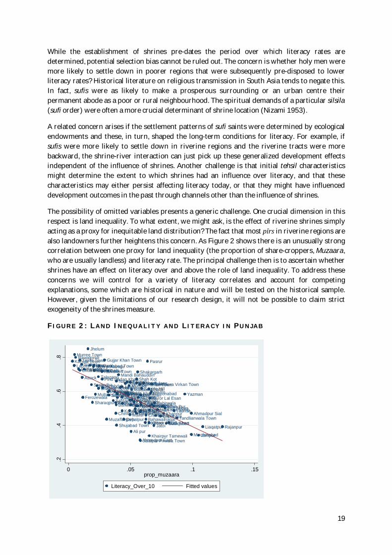
The possibility of omitted variables presents a generic challenge. One crucial dimension in this respect is land inequality. To what extent, we might ask, is the effect of riverine shrines simply acting as a proxy for inequitable land distribution? The fact that most pīrs in riverine regions are also landowners further heightens this concern. As Figure 2 shows there is an unusually strong correlation between one proxy for land inequality (the proportion of share-croppers, Muzaara, who are usually landless) and literacy rate. The principal challenge then is to ascertain whether shrines have an effect on literacy over and above the role of land inequality. To address these concerns we will control for a variety of literacy correlates and account for competing explanations, some which are historical in nature and will be tested on the historical sample. However, given the limitations of our research design, it will not be possible to claim strict exogeneity of the shrines measure.
F I G U R E 2 : L A N D I N E Q U A L I T Y A N D L I T E R A C Y I N P U N J A B
Ahmadpur Sial
Ahmedpur East
Ali pur
Arifwala
Attock
Bahawalnagar
BahawalpurBhakkar
Bhalwal
Burewala
Chak Jhumra Town
Chakwal
Chichawatni
Chinniot
Chishtian
Choa Saidan Shah
ChoubaraChunian
DG Khan
Darya Khan
Daska
Depalpur
Dunya PurEssa Khel
Faisalabad
Fateh Jang
Ferozewala
Fort Abbas
Gojra
Gujjar Khan Town
GujranwalaGujrat
HafizabadHaroonabad
Hasanabdal
Hasilpur
HazroJahanian
Jalalpur Pirwala TownJampur
Jand
Jaranwala Town
Jatoi
Jhang
Jhelum
Kabirwala
Kahuta Town
Kallur Kot
Kamalia
Kamoke Town
Karor Lal Esan
Kasur
Kehror Pacca
Khairpur Tamewali
Khanewal
Khanpur
Kharian
Khushab
Kot AdduKot Momin
Lahore
Layyah
LiaqatpurLodhran
Mailsi
Malakwal
Mandi Bahauddin
Mankera
Mian Channu
Mianwali
Minchinabad
Multan
Muridke
Murree Town
Muzaffargarh
Nankana Sahib
Narowal
Noorpur Thal
Nowshera Virkan Town
Okara
Pakpattan
Pasrur
Pattoki
Phalia
Pind Dadan Khan
Pindi Bhattian
PindighebPiplan
RY Khan
Rajanpur
Rawalpindi
Renala Khurd
Sadiqabad
SafdarabadSahiwalSahiwal2
SambrialSangla Hill
Sara-e-Alamgir
SargodhaShah Kot
Shahpur
Shakargarh
Sharaqpur Sharif
Sheikhupura
Shorkot
Shujabad Town
Sialkot
Sillanwali
Sumundri TownTT SinghTalagang
Tandlianwala Town
Taunsa
Taxila Town
Vehari
Wazirabad Town
Yazman
.2.4
.6.8
0 .05 .1 .15prop_muzaara
Literacy_Over_10 Fitted values
20
IV. Main Findings
This section discusses the main empirical findings. Our basic specification consists of models of literacy measured at the level of tehsils, and our principal variable of interest is the indicator of shrines per capita interacted with the distance from river. As described above, our interest lies in exploring the non-linear impact of shrines. Our specific prior is that the effect of shrines on literacy can systematically vary depending on whether they are situated in a tehsil that is closer or distant from river. The estimations are based on a sample of 118 tehsils.79
Shrines and Literacy
The initial set of results is documented in Table 2. The dependent variable is the total literacy rate for years 10 and above. Column (1) explores the non-linear impact of shrines by including the shrines indicator on its own as well as its interaction with the distance from river. We also control for distance from river, the latitude and longitude measured at the tehsil level. As expected, the coefficient on the shrines per capita indicator, capturing the impact of riverine shrines, is negative and statistically significant. The coefficient on the interaction term, on the other hand, is also statistically significant.80 Given the inclusion of both the shrine measure and its interaction term the parameter estimates on the two terms need to be interpreted together. Evaluated at the mean distance from river, the impact of shrines on literacy is negative and statistically significant.81 Overall, the results strongly support the suggestion that the impact of riverine shrines on literacy is significantly different from that of shrines situated in tehsils relatively distant from river. The model explains about 49% of the total variation in literacy rate.
The above results are robust to the inclusion of an additional geographic attribute: the log of elevation. Whilst the negative impact of riverine shrines on literacy remains, the coefficient on elevation is positive and statistically significant at the 1% level. Apart from capturing regional effects, the elevation measure is also likely to pick up the effect of other development dimensions. For example, elevation is a strong correlate of rainfall patterns, soil quality and land inequality.82 While the initial set of results is re-assuring, it is possible that the impact of riverine shrines is simply proxying for the impact of land inequality. We directly test this in column (3) by adding a proxy for land inequality, the proportion of Muzaara (landless tenants). As expected, the results indicate a very strong negative association between land inequality and literacy. This is consistent with the argument that landlessness combined with productive agriculture is associated with illiteracy. Measured at the end of the sample period, the negative effect of Muzaara suggests that land inequality and literacy are jointly determined. Importantly, however, the impact of riverine shrines remains negative and statistically robust to the inclusion of this powerful correlate of literacy.
So far, our models have not directly accounted for the regional effects. As Cheema et al. (2008) have suggested, the south and western parts of Punjab systematically underperform relative to other regions on most development outcomes. We explore this possibility in column 4 by adding 79 See Appendix 3 for a complete list of tehsils. 80 When separately included, in the absence of the interaction term, the coefficient on distance from river is statistically insignificant. 81 The precise size of the impact can be calculated as: -3.1227 + 0.1411 x (21.155). 82 Geographically the average altitude falls as we move from North to South Punjab. Both rainfall and land inequality follow a similar pattern.

21
dummy variables for Northern, Central and Southern Punjab (with west Punjab being the base category). The coefficients on neither of these regional dummy variables are significant, whilst the impact of riverine shrines and land inequality are negative and statistically significant. The same pattern of results holds when we replace the dependent variable with the literacy rate for years 15 and above. The results are presented in Columns (5) to (7).
Shrines and physical access to schools
We next consider the impact of shrine concentration on physical access to schools, both public and private. Since literacy is a final outcome variable it is also worth exploring the impact of shrines on a more direct measure of public goods provision: physical access to schools. For this purpose, we rely on three categories of physical access provided by the MICS database, all based on distance from the nearest school. Physical access is closer if the nearest school is situated less than two kilometres away from the surveyed household. Schools that are located between 2 and 5 kilometres away are relatively more distant. Finally, schools that are more than five kilometres away are the farthest. We explore variation in these categories across two metrics: gender (boy versus girl) and provider (public versus private). Results for these specifications are presented in Table 3. Apart from the main variables, each specification contains the natural log of population and the full range of geographic controls.83
Firstly, we consider models measuring physical access to government schools. Results are presented only for categories for which our main explanatory variable (shrines per capita) is statistically significant. As documented in column (1), a greater concentration of riverine shrines is associated with provision of government schools that are relatively more distant (2-5 km). A similar result is obtained for public provision of schools for girls. Prima facie, when shrines are concentrated in tehsils more proximate to river, physical access to girls’ schools is relatively more difficult (see column 2). The shrine variable lacks explanatory power, however, for the two extreme categories: less than two and more than five kilometres away (results not reported in Table 3). However, tehsils with riverine shrines tend to have a lower provision of more accessible government schools for girls (i.e. those less than 2 km away).
We next turn to models for access to private schools. Results for these are reported in columns (4) and (5). Evaluated at the mean distance from river, the shrines per capita indicator is positively associated with measures of physical access to private schools. Specifically, greater concentration of shrines in riverine tehsils is associated with a relatively defective provision of private schools, both for boys and girls. Although this is consistent with the pattern observed for access to government schools, private school provision can encapsulate a variety of other effects, such as income and demand for schooling. The results are robust to the inclusion of a variety of geographic controls and the population variable.84 Interestingly, our land inequality measure is a not a significant correlate of physical access of schools in any of the reported models. It is, however, more strongly correlated with access measures denoting more distant provision, i.e., schools situated more than 5 km away (results not reported). As Figures 2 and 3
83 The population variable is included to account for the fact that more populous regions are likely to have higher levels of school provision. 84 The latter has a positive and significant effect in models for government schools.
22
show tehsils with a greater proportion of Muzaara suffer from a systematic under-provision of accessible public schools.85
Possible channels of influence
Results presented so far suggest that the presence of riverine shrines is associated with adverse outcomes on literacy and a more defective physical access to schools. In this section we consider possible channels through which the impact of riverine shrines on literacy may be mediated. Recalling our initial thoughts on this subject, shrines located in riverine tracts may be associated with a radically different political economy from those situated afar from river. This can be attributable to the confluence of three factors in such regions: religion, land and politics. Together, they can generate a powerful structural inequality with fundamental implications for development.
Table 4 explores these ideas in the empirical domain by considering models that simultaneously investigate the impact of riverine shrines with the two other explanations: land and politics. To capture these effects simultaneously we define three separate dummy variables: River, Muzaara and Politics. The River Dummy picks out tehsils that are proximate to the river (these are tehsils whose distance from the river is less than or equal to the top 25th percentile of the overall distribution of distance from river). The interaction between this dummy variable and shrines per capita allows the coefficient on the latter to be different for riverine and non-riverine shrines.86 The usual geographic effects (latitude, longitude and elevation) are included in all specifications.
Beginning with results in column (1), the coefficient on the interaction term between shrines and River dummy is negative and statistically significant. As before, this supports our main contention—that a greater concentration of shrines per capita in riverine tehsils is associated with lower levels of literacy (Year 10 and above). Importantly, the negative impact of shrines on literacy is mainly driven by riverine shrines. The result raises a larger question about the impact of riverine shrines: Is the river effect simply acting as a proxy for deeper political economy aspects related, for example, with the influence of land and politics? To test this, the specification in column (2) introduces a dummy variable, Muzaara, that takes a value of one in tehsils where the proportion of Muzaara is greater than or equal to the 75th percentile of the variable’s distribution; zero otherwise.87 The interaction of Muzaara dummy with shrines indicator effectively allows the coefficient on shrines per capita to be different for tehsils with high and low levels of land inequality. The results suggest that, although the coefficient on the interaction term is individually insignificant, land inequality itself is negatively correlated with literacy (the coefficient on Muzaara dummy is negative and significant at 10% level). Importantly, the shrines-river interaction still has a robust negative impact on literacy.
85 For completeness sake, we also investigated the empirical association between the presence of shrines and access to government health facilities (health centres situated within 29 minutes are considered more accessible). The results showed that greater concentration of shrines in riverine tehsils is associated with a relatively defective provision of government health centres. Conversely, health centres are relatively more distant in such tehsils. Results were obtained after controlling for population and land inequality, coefficients on which were both individually significant. Compared with results on physical access to schooling, the negative correlation between land inequality and public health provision is more statistically significant. 86 The term, riverine, is loosely used to denote shrines that are proximate to the river as classified by the dummy variable above. 87 The 75th percentile of the Proportion Muzaara is equivalent to .0636.

23
The model in column (3) imposes a more stringent test by including all three dimensions together (River, Muzaara and Politics). The political influence of shrines is mapped by constructing a separate dummy variable that equals one in tehsils where a shrine-related family has a direct connection with politics. Direct political connection is measured through participation by the guardian of a shrine in general elections, either at the provincial or national level. As before, we include the interaction between the Politics dummy and shrine indicator to isolate the effect of shrines in regions where they have a direct connection with electoral politics. Together with the other two dummy variables (River, Muzaara) and their respective interaction terms, this allows us to estimate the differential impact of shrines per capita across the three categories defined above.
The results are instructive. Inclusion of the politics interaction renders the coefficient on our main interactive term between shrines per capita and the River dummy statistically insignificant. The Politics interaction now has a negative and statistically significant coefficient, however. While the coefficient on Muzaara dummy is still negative and significant, it’s interaction with the shrines indicator lacks explanatory power. Together, these results are consistent with the suggestion that the impact of riverine shrines is mediated through politics. The result is robust to the inclusion of regional dummy variables in column 4. Repeating the same exercise for models of literacy rate over 15 preserves the basic pattern of results (see columns 5-8).
These findings clearly indicate that the adverse impact of riverine shrines on literacy is principally mediated through their influence on local political economy. As the analytical narrative in section II has argued, prominent shrines dotted along the rivers of Punjab have traditionally acted as important nodes of power, where structures of religious and political authority has been historically co-determined. Through their control of the three critical resources—religion, land and politics—they are a key constitutive element of the local power structure. As powerful intermediaries between the state and people, guardians of these shrines can control the provision of public goods.
Before closing this section, two nuances are in order. Firstly, it is important to unpack the political dimension. Although the politics interaction is robust to the inclusion of the Muzaara dummy—and hence not simply capturing the effect of land inequality—shrines with a political influence invariably control both land and politics at the local level. This is confirmed by eyeballing the data on shrine-related political families and matching it with selective interviews and qualitative data. Invariably, politically linked shrines have either direct or indirect control over vast tracts of agricultural land. Caretakers of these shrines are therefore not simply pīrs, but pīr-zamindars. Today, nearly all leading pīr families own substantial tracts of land.88 Their landed power is largely hereditary. For example, even in 1890s the Chishtis of Pakpattan Sharif owned 9 percent of all land in the Pakpattan tehsil.89
Secondly, given that our results are based only on direct evidence of a shrine family’s entry into politics, they understate the true relationship between shrines and politics. Even if a shrine
88 The pīrs also consolidate their power through strategic marital alliances with large landowners. Urban shrines have also continuously added to their existing land holdings. For example, the Pīr of Golra Sharif has sizeable landholdings in and around Islamabad. Even shrines with more limited economic fortunes tend to function with the patronage and support of local landlords. 89 Final Report of the Revision of Settlement of the Montgomery District, 1892-99.
24
lacks direct electoral representation, it can play a crucial indirect role by garnering support for election candidates. A relevant example, in this regard, is the shrine of Shaikh Fazil in Burewala that is better known for its indirect political brokerage than direct electoral contest, and has an impressive political footprint on multiple constituencies of Punjab.90 Support of the shrine of Golra Sharif is similarly deemed critical for candidates from many neighbouring constituencies in Islamabad and Rawalpindi.
Overall, these results provide only first-cut evidence on the empirical relationship between shrines and development. In subsequent sections, we will address some rival explanations and related empirical challenges.
V. Robustness tests
This section conducts a battery of robustness tests to ascertain the strength of our empirical findings. A key challenge in reduced form specifications is to ensure that the results are not contaminated by omitted variables. To address this we augment our basic model specification with additional covariates and replicate the main results on the historical sample. Finally, we address the possible endogeneity of Proportion Muzaara by presenting results from some tentative IV (instrumental variable) specifications.
Additional covariates
The first set of results is presented in Table 5. The first possibility that we check is whether the distance from river captures other dimensions that systematically predispose some tehsils to have lower literacy rates. For example, if regions proximate to the river are poorer and relatively underdeveloped they are likely to be more illiterate as well. To control for this possibility we control for a commonly used proxy for income, mean rainfall. We use the average annual rainfall over the period, 1960-2008. The result is presented in column 1. As expected rainfall is a strong predictor of literacy: its coefficient is positive and significant at 1% level. Apart from being associated with land inequality91, rainfall captures many unobserved dimensions of income and development. It is reassuring, however, that the negative impact of riverine shrines, captured by the coefficient on shrines per capita, continues to be robust.
Some previous work on Punjab has also controlled for distance from Lahore to reflect core-periphery dynamics in development. Other studies have sometimes controlled for distance from the GT (Grand Trunk) road. 92 It might be the case that tehsils with characteristics least favourable to literacy were also remote from the centre of power and, as a result, suffered from a substantial power vacuum that was filled by shrines. Shrines would then simply capture the impact of remoteness. Columns 2 and 3 control for these dimensions (given its significance we retain average rainfall in the model). Neither of these have much explanatory power. Finally, column 4 assesses the importance of spatial dimensions in mapping the role of shrines. The influence of major shrines usually extends beyond the tehsils where they are situated. The religious festivals organized around prominent shrines typically attract devotees from far flung
90 As a regular election ritual, candidates from neighbouring constituencies queue up in Shaikh Fazil to seek spiritual and political support. 91There is a strong negative correlation between rainfall and land inequality. Land is more unequally distributed in low-rainfall regions. 92 GT Road stands for Grand Trunk Road, a major road artery connecting Central Asia with eastern and western parts of the Indian subcontinent. We use the natural log of the variable.

25
areas as well. In this sense it may be important to account for shrines in the neighbouring regions. We constructed a new variable, neighbouring shrines per capita, by adding up the total number of shrines in all the contiguous tehsils and weighting it by the total population of these contiguous tehsils. Adding this variable to our model in column 4 keeps our results unchanged, however.
Historical sample
Another concern that might contaminate our results is the exclusion of historical literacy rate from our models. A well-known finding in the literature is the considerable persistence in literacy rates over time. This has important implications for our results. If regions with riverine shrines had historically lower literacy rates to begin with then the negative impact of riverine shrines could simply capture these adverse initial conditions. The exclusion of other historically determined tehsil characteristics from our model poses a similar challenge. We try to address these concerns by re-estimating our model on the sample of colonial tehsils and including historically pre-determined characteristics in the model. This requires that we fix tehsil boundaries at 1931, the census year for which historical data is readily available. Data on 118 contemporary tehsils were therefore collapsed into data for 69 colonial tehsils. The underlying mapping strategy is discussed in detail in Appendix 2.
Results for this exercise are presented in Table 6. Our historical sample, consisting of 61 colonial tehsils, is dictated by data availability and is listed in Appendix 4.93 A range of historical variables were compiled from various District Gazetteers and Census Reports. We assess the robustness of our final explanation, the political influence of shrines. Column 1 includes a dummy variable for tehsils with politically influential shrines and, interacts it with our main variable of interest, shrines per capita. The usual set of geographic controls, including average rainfall measured for 1923, is also included. Consistent with our argument, a greater concentration of shrines in tehsils where shrine families have a direct political presence tend to suffer from systematically lower literacy rates (year 15 and above). Results on the historical sample confirm that the presence of shrines is harmful for literacy only in tehsils where shrines have a manifestly political role (these are usually regions where the political economy of shrines is deep and persistent. As expected, rainfall is a strong and positive predictor of literacy. The statistically significant coefficient on regional dummy for north Punjab suggests an unexplained literacy differential between north and west Punjab. One plausible explanation relates to the beneficial effect of military recruitment on the spread of literacy (north Punjab has historically been a recruitment for British and, later, Pakistani military).94
We then proceed to controlling for historical land inequality in column 2. To measure land inequality we use detailed information on land tenure contracts from various editions of District Gazetteers compiled by the British colonial administration. Typically, District Gazetteers divided land tenure contracts into four categories: zamindari, pattidari, bhayachara, imperfect bhayachara and Government-owned lands. Our main interest is in the proportion of the total number of villages governed by zamindari contracts.95 Land held in zamindari contracts
93 The sample size reduced from 69 to 61 tehsils due to unavailability was dictated by data availability. 94 The role of military recruitment in human capital accumulation in colonial Punjab has been discussed in greater detail in Eynde (2011). 95 Ideally it would be more appropriate to estimate the total area under zamindari contracts, rather than counting the number of villages. However, the coverage of data on land tenures by area is very sparse.
26
recognized proprietary rights of individual owners and entailed a direct payment. 96 Effectively, the contracts recognized the de facto ownership and influence of large landlords. Adding the zamindari variable in column (2) results in a weakly significant coefficient and suggests a negative impact of historical land inequality on contemporary literacy. Importantly, however, the interaction between shrines and politics retains its explanatory power.
We next control for the historical literacy rate. The first possibility we entertain relates to the literacy rate in 1951 of migrants crossing over from India to Pakistan in the wake of the 1947 partition. If tehsils with riverine shrines attracted relatively less literate migrants than that could be a potential confounding factor. The result in column 3 dispels this concern: the migrant literacy rate enters with a statistically insignificant coefficient. Column 4 controls for a more important confounding factor, the historical literacy rate in 1931, compiled from the Punjab Census Report 1931. The variable lacks any additional explanatory power, and its coefficient is not significantly different from zero. Importantly, the interactive effect of shrines is solid and robust. Repeating these results for models for literacy rate over 10 yields the same conclusion. This suggests that our results are not simply driven by the exclusion of historical literacy rate.
We experimented with a range of other historical characteristics that might have a bearing on contemporary literacy and compete with our shrine explanation. Prominent amongst these are: the proportion of total cultivated area that is irrigated97; a measure of religious diversity98; and the number of zaildars per capita (local revenue collectors).99 To conserve space, results for these are not reported in Table 6; none of these dimensions had a significant impact on literacy, however. Our models, when estimated on the historical sample, explain more than 70% of the variation in literacy rate. Importantly, our emphasis on the political economy of shrines is maintained even after controlling for historical dimensions.
Instrumenting Muzaara
Our principal indicator of land inequality, Proportion Muzaara, is measured at the end of the sample period that raises concerns of a possible simultaneity bias. Given that occupational selection can be determined by initial human capital endowments in the first place, it is challenging to interpret the effect of Muzaara. This is unlikely to radically alter our main finding on riverine shrines. Patterns of land inequality are highly persistent in Pakistan; our contemporary measure is likely to be highly correlated with historical inequality. Still, the possibility of a negative feedback from literacy to land inequality is likely to understate the true impact of Muzaara.
To address this we estimate IV specifications where Proportion Muzaara is instrumented with the mean distance from Lahore and the distance from Grand Trunk Road. These instruments
96 In Pattidari, both the land and revenue were divided in accordance with ancestral or customary shares as per the laws of inheritance. Under Bhayachara contracts, possession was the measure of right of land. Through both Pattidari and Bhayachara the de facto land tenure arrangements that pre-existed the British rule were recognized. Another category, imperfect bhayachara and pattidari, denoted a situation where the land was held partly in severalty and partly in common; the measure of right in common land was the amount of the share or the extent of land held in severalty. 97 Specifically, proportion of cultivated area characterized as Nahri and Chahi Nahri in District Gazetteers and Census Reports. 98 The variable combines census information on the proportion of population identified as Muslim, Hindu, and Sikh. 99 Zaildars were effectively village headmen in charge of tax collection from their respective zails (revenue extraction units – usually a collection of villages). Typically, zaildars were locally influential landlords.
27
have intuitive relevance. As distance from Lahore increases, both social and agro-climatic conditions tend to favour large landholdings. Some of these patterns emanate from historically embedded compulsions of imperial power. Perennial tensions between the core and periphery meant that centralized rulers had to largely depend on local elites for governing remote regions, potentially leading to greater elite entrenchment and concentration of economic resources. Historically, regions that were weakly connected to the centre afforded limited opportunities for labour mobility, reinforcing prior inequalities. From a purely statistical standpoint, the two instruments are good candidates for meeting the exclusion restrictions, since they do not have any independent effect on literacy over and above the role of Muzaara and rainfall (see Table 5).
Results for the IV specifications are presented in Table 7. As before the dependent variable is literacy rate for individuals aged 10 years and above. The full set of dummy variables are included in the model, but not reported. Columns (1) and (2) present estimates from Two Stage Least Squares (2SLS).100 Starting with a specification without average rainfall in column (1) we obtain negative and strongly significant coefficients on Muzaara and the term capturing the effect of riverine shrines. We report diagnostic tests for weak identification and validity of instruments. As the results suggest, the null for weak identification is strongly rejected; however, the null of valid instruments for Sargan test is rejected. Column (2) presents results for an augmented IV specification that includes the log of average rainfall (recall that it was a strong predictor of literacy in previous regressions). This produces a more robust set of results: while the coefficient on shrines per capita is largely unchanged relative to Table 5 we obtain a strong negative impact of proportion Muzaara.101 Importantly, we now fail to reject the null of valid instruments for the Sargan test.
The added variable plots for the two instruments suggest a strong first stage relationship between the excluded instruments and Muzaara (see Figures 4-5). Columns (3-4) document the GMM estimates. For an over-identified equation the IV-GMM estimates are likely to be more efficient and robust to heteroscedasticity. The results are reassuringly robust. The coefficient on shrines per capita is now significant at 5% level, and we can confidently reject the null of under-identification for the Kleibergen-Paap test. Similarly, the p-value of the Hansen-J test supports the validity of instruments.102 These results remain unchanged when we re-estimate the model with a different dependent variable, literacy rate over 15 (col. 4).
VI. Determinants of political selection
If the impact of riverine shrines on literacy is mediated through politics, it is worth asking: What factors determine the selection of shrines into politics? As argued in section II, the local influence of pīrs, their capacity to act as intermediaries and their control of landed property act as crucial political assets. The pīrs established an early foothold into politics, dating back the pre-partition era when noted shrine families participated in the 1937 and 1946 elections. As Table 1 shows, many of these families have persisted in electoral politics after independence.
100 IV models were estimated using the ‘ivreg2’ command in stata. 101 At face value, relative to Table 5 (col. 1) the coefficient on Muzaara now increases from to 1.888 to 2.565, although there is a significant increase in the standard error as well. 102 The Sargan-Hansen is a test of over-identifying restrictions with the null hypothesis that the instruments are valid (i.e. uncorrelated with the error term).
28
In probing the determinants of political selection, we emphasize factors embedded in the political history of colonial Punjab. Our main prior is that shrines that enjoyed greater influence in the colonial era are more likely to have entered into politics in post-partition Punjab. To capture this, we draw upon the historical database described in section III that records the number of shrines in a tehsil that were mentioned in District Gazetteers. Typically, the Gazetteers recorded shrines that wielded greater influence over local political economy. These shrines were more likely, in turn, to receive colonial patronage and enter into electoral politics.
Qualitative evidence offers support for this hypothesis. For example: the Kirmani Syeds of Shergarh, who entered into politics in 1920s and survive in the parliament to this day, were recognized by the British through a sizeable land grant (1,168 acres).103 The Kirmanis and their shrine, Daud Bandagi, were similarly recognized in the District Gazetteer. In fact, this is true for all politically resilient shrine families mentioned in Table 1. We explore this historical connection in the empirical domain.
Results
Drawing on these two unique databases, we now examine our claim that historically important shrines are more likely to select into electoral politics in post-independence Punjab. To investigate this we run probit models for the dichotomous dependent variable, coded one for tehsils where shrines have a direct electoral linkage, zero otherwise (see section III for a detailed discussion of the politics database). Our main explanatory variable for political selection is a count variable, the total number of shrines in a tehsil mentioned in the relevant District Gazetteer (PDG). The complete list of shrines mentioned in PDGs is available in Appendix 2. In some specifications we define a separate dummy variable, coded as one for tehsils with a shrine mentioned in the Gazetteer. Figures 6-7 visually represent the spatial distribution of shrines across these two metrics: history and politics. All across Punjab there is evidence of historically influential shrines, but south-western parts of Punjab have a greater concentration of such shrines (as indicated by the bigger circles on the map in Figure 6). There is also a larger presence of politically influential shrines in south-west Punjab (Figure 7).
Table 8 presents the results for this investigation. For ease of interpretation, we report marginal probability effects for different variables.104 Column (1) in Table 8 provides an initial test of our prediction. As expected, the coefficient on the variable that counts the number of shrines mentioned in PDGs is positive and statistically significant at the 1% level. This suggests that as the average number of shrines mentioned in PDG increases by an infinitesimal amount, the probability that a tehsil has politically affiliated shrine(s) increases by 8.4%. Column (2) controls for various geographic attributes. These include: distance from river, latitude, longitude and elevation.105 While the coefficient on the log of elevation is negative and significant, the effect of our historical shrine variable remains fairly robust.
103 This was, in fact, one of the largest land grant given to a Muslim shrine in the Montgomery District. For further details, see the Final Report on Settlement of the Montgomery District. 104 Marginal probability effects are the partial effects of each explanatory variable on the probability that the observed dependent variable equals 1. These are estimated at the sample mean values of regressors. The ‘dprobit’ command in stata was used to compute the maximum likelihood estimates of these effects. 105 The last three variables are expressed in natural log.

29
F I G U R E S 6 : S H R I N E S M E N T I O N E D I N D I S T R I C T G A Z E T T E E R S ( N U M B E R )
F I G U R E S 7 : P O L I T I C A L L Y I N F L U E N T I A L S H R I N E S ( N U M B E R )
30
This impact also holds up to the inclusion of regional fixed effects in column (3), the coefficients on all of which are positive and statistically significant. For instance, if the dummy variable for central Punjab takes the value one, the probability that the tehsil has a politically affiliated shrine increases by 47 percentage points relative to western Punjab.
It is possible that shrines have a greater political role in tehsils with a more unequal land distribution. We checked this by entering Proportion Muzaara in the model (results not shown). It was neither significant on its own nor did it dislodge the impact of historical shrine concentration. Experimenting with an alternative, district-level, measure of land inequality yields a more informative result. Column (4) includes the proportion of total cultivated area in a district that is 25 acres and above. The source for this data is the Agricultural Census of Pakistan.106 While the coefficient on the alternative land inequality measure is positive and significant at 10% level, the PDG variable retains its robust influence, indicating that it is not simply capturing underlying land inequality. The diagnostic chi-square test suggests that our model fits the data reasonably well.107
The preceding analysis provides strong support for our argument that the likelihood of a tehsil containing a politically linked shrine increases as the average number of shrines mentioned in PDGs rises. What it does not test, however, is the role of historical literacy rate on the probability of political selection. This may be important to control, since tehsils with a historically lower literacy rate may also have a greater concentration of PDG shrines. We test this possibility in Table 9 that runs similar probit models on our historical sample consisting of 69 tehsils.108 In these specifications we use a dummy variable selecting tehsils containing at least one shrine mentioned in PDGs.109
The initial pattern of results also holds in the historical sample. Whether included on its own (col. 1) or with geographic controls (col. 2), the coefficient on the PDG dummy variable is positive and statistically significant. Importantly, the inclusion of the historical literacy rate (based on the 1931 census of Punjab) in column (3) has no impact on our main result. In fact, the coefficient on PDG dummy is now statistically significant at 1% level. This means that if the PDG dummy changes from zero to one, the probability that a tehsil has a political shrine increases by 42 percentage points. Separately, historical literacy has a negative impact. Here, calculated at the mean values of control variables, a small increase in the average historical literacy rate decreases the probability of a tehsil with a political shrine by 51%.110
In short, tehsils with shrines considered as historically important, as measured by their mention in PDGs, predict their selection into politics. Importantly, the underlying pattern is not simply driven by lower initial historical literacy rates in such tehsils or regional fixed effects. Taken together, the above results indicate a strong pattern of persistence. In thinking about historical
106 We used data from the 2010 Census. Further details are available at: http://www.pbs.gov.pk/agriculture-census-publications 107 The Pearson chi-square test, which is a test of the observed against expected number of responses using cells defined by the covariate patterns, is estimated using the estat gof command in stata. 108 Please refer to Appendix 4 for a complete list of tehsils included in the historical sample. 109 The total count variable for PDG shrines lacks explanatory power in the historical sample. 110 Including a measure of historic land inequality (the proportion of zamindari villages) together with the 1931 total literacy rate doesn’t alter the results.

31
persistence of shrine influence, a key institutional moment is the introduction of the property rights regime by the British. The 1900 Land Alienation Act, together with new forms of colonial patronage, systematically transformed (and entrenched) the political economy of shrines.
VII. Conclusion
This paper has shed light on how structural inequality—defined by the powerful configuration of religion, land and politics—shapes contemporary development outcomes in Pakistani Punjab. We have argued that considering ways in which religious shrines in riverine regions influence literacy can provide a critical window into the subject. Drawing on a unique compilation of data on shrines capturing their contemporary, historical and political dimensions, we demonstrate that a greater concentration of shrines in riverine tehsils is associated with lower literacy rates on average. The result is robust to controlling for a variety of controls, including land inequality, which is itself one of the most significant correlates of literacy. Another contribution of this paper is its focus on possible channels of transmission. We show that the impact of riverine shrines on literacy is principally mediated through their influence on politics. The impact of shrines is largely driven by tehsils where prominent shrine families have directly entered into electoral politics.
Given that the connection between pīrs and politics is often consummated through large landholdings, these findings testify to the importance of the interplay between religious, landed and political power. Going a step further, we also probe the determinants of political selection, and discover that shrines considered as historically important, as reflected in their recognition and patronage from British colonial authorities, were more likely to select into politics in post-colonial Punjab. While colonial patronage for shrines was part of a long-standing tradition of rewarding shrine guardians, it was accompanied, under British rule, with “structural transformations” in the property rights regime through introduction of the 1900 Land Alienation Act. Cementing the nexus between religious and landed elites of Punjab, colonial rule led to a significant consolidation of the underlying power structure. Although we are careful not to ascribe a causal interpretation to these results, the underlying statistical pattern is both robust and consistent. Both qualitative and quantitative evidence suggests a strong persistence of the political economy of shrines.
While past literature has investigated the influence of shrines mainly through a non-economics lens, this paper offers the first systematic application for development. Our findings support the intuition of both historical and contemporary observers (ranging from Darling to Aziz and Lieven) that perceived pīr-zamindārs as an obstructive force against educational progress. Apart from enriching the discourse on Punjab’s political economy of development, our analysis also casts fresh light on the broader literature on religion and development. Rather than painting a uniformly bleak picture of shrines, we argue that the relationship between religion and development is mediated by the underlying power structure.111
A comparison with sufi shrines in Northern India can be instructive in this regard. Although similarly patronized by past rulers through revenue-free land grants, sufi establishments in India witnessed a substantial decline in their material fortunes, firstly, under British rule, due to
111 It is pertinent to here to highlight the useful role of shrines in acting as a safety valve against the shia-sunni sectarian divide, and in offering a range of useful services for the poor and mentally challenged. Our emphasis is mainly on the ways in which shrines interact with the underlying power structure.

32
succession battles in civil courts, and, secondly, after the introduction of land reforms in 1950s. Jafri (2006) shows how the financial fortunes of a prominent shrine in southern Awadh suffered after the enactment of UP Zamindari Abolition and Land Reforms Act 1952. While the connection between religion, land and politics was decoupled after independence in India, it was structurally consolidated in Pakistan. Future research can consider such comparisons in more detail. While, within Pakistan, our analysis is centred on Punjab, extending it further south to Sind province is only likely to reinforce our argument, since the fusion between religion, land and politics is even stronger in Sind (see Ansari 1992).112
Our research has concrete implications for policy. Pakistan has witnessed a persistent education crisis, marked by low education spending and poor education indicators. A recent UNESCO Report ranks Pakistan as second, after Nigeria, among the list of top ten countries with the “highest out-of-school populations” (UNESCO 2014). The country is also described as “severely lagging” in its goal of achieving universal education.113 In this milieu, educational expansion is not just about scaling up resource endowments or offering donor support for advocacy campaigns (as DfiD’s £9 million advertisement campaign seeks to do).114 It also requires addressing structural inequalities that are both deep and persistent. Malcolm Darling correctly observed in 1928 that “in agriculture the social factor is as important as the economic”. 115 Few would disagree today that the same is true for education.
112 Shrines in Sind also received significant colonial patronage. As Aziz (2001: p. 17-18) notes, “according to official reports, at the time of the British arrival in Sindh the revenue appropriated to ecclesiastical establishments amounted to one third of the total revenue of the government”. 113 UNESCO website on Pakistan: Achieving Universal Primary Education - Where are We? 114 For more details on the DfiD-sponsored advocacy campaign, visit the website: http://www.alifailaan.pk/ 115 Darling (1928: p. 258).

33
References
Acemoglu, Daron and James Robinson. (2012). Why Nations Fail? New York: Crown Publishers.
Acemoglu, Daron, Francisco Gallego and James Robinson (2014). “Institutions, human capital and development”, Annual Review of Economics, forthcoming.
Albinia, Alice. (2008). Empires of the Indus – The Story of a River. London: John Murray Publishers.
Ali, Imran (1988). The Punjab under Imperialism 1885 - 1947. Princeton: Princeton University Press.
Anjum, Wakeel. (1990). Siasat Key Firaun. Lahore: Feroz Sons Publishers.
Anjum, Wakeel. (1995). Siasat Danaun Kee Kalabaziyan. Lahore: Feroz Sons Publishers (three vols).
Ansari, Sarah. (1992). Sufi Saints and State Power: The Pīrs of Sind 1843-1947. Cambridge: Cambridge University Press.
Aziz, Khurshid Kamal. (2001). Religion, Land and Politics in Pakistan: A Study of Piri-Muridi. London: Vanguard Publishers.
Barro, R.J. and McCleary, R. (2003). “Religion and economic growth across countries.” American Sociological Review 68, 760–81.
Bharadwaj, Prashant, Asim Khwaja and Atif Mian. (forthcoming). “The Partition of India: Demographic Consequences”, International Migration.
BNU (Beacon House National University). (2012). Fifth Annual Report on the State of the Economic: The Punjab Story. Lahore: Institute of Public Policy.
Brown, Peter. (1971). “The rise and function of the holy man in late antiquity”, Journal of Roman Studies 61: 80-101.
Cheema, Ali, Lyla Khalid and Manassa Patnam. (2008). “The geography of poverty: Evidence from the Punjab”, Lahore Journal of Economics, 13 (Special Issue): 163-188.
Darling, Malcolm. (1928). The Punjab Peasant in Prosperity and Debt. Oxford: Oxford University Press.
Eaton, Richard M. (1984). “The Political and religious authority of the shrine of Baba Farid”, In Barbara Metclaf, ed., Moral Conduct and Authority: The Place of Adab in South Asian Islam. Berkeley: University of California Press.
Ewing, Katherine. (1983). “The politics of Sufism: Redefining the saints of Pakistan”, The Journal of Asian Studies, 42(2): 251-268.
Eynde, Oliver Vanden. (2011). “Military service and human capital accumulation: Evidence from Colonial Punjab”. Unpublished paper. http://www.parisschoolofeconomics.eu/docs/vanden-eynde-oliver/milservice.pdf
FAFEN (Free and Fair Election Network). (2010). National Assembly Elections in Pakistan 1970-2008. Islamabad: FAFEN.
Gallego, Francisco A. (2010). “Historical origins of schooling: The role of democracy and political decentralization”, Review of Economics and Statistics, 92(2), 228-243.
34
Gennaioli, Nicola, Rafael La Porta, Florencio Lopez-de-Silanes, and Andrei Shleifer. (2013). “Human capital and regional development”, Quarterly Journal of Economics, 128(1), 105-164.
Gilmartin, David. (1979). “Religious Leadership and the Pakistan Movement in the Punjab,” Modern Asian Studies (July issue): 485-517
Gilmartin, David. (1984). “Shrines, succession and sources of moral authority”, In Barbara Metclaf, ed.,
Moral Conduct and Authority: The Place of Adab in South Asian Islam. Berkeley: University of California Press.
Gilmartin, David. (1988). Empire and Islam: Punjab and the Making of Pakistan. Berkeley: California
University Press.
Gilmartin, David. (2010). “Sufism, exemplary lives and social science in Pakistan”, In Carl Ernst and Richard Martin, eds., Rethinking Islamic Studies: From Orientalism to Cosmopolitanism. South Carolina: University of South Carolina Press.
Glaeser, Edward L., Rafael LaPorta, Florencio Lopez-de-Silanes, and Andrei Shleifer. (2004). “Do Institutions Cause Growth?” Journal of Economic Growth, 9(3), 271-303.
Guiso, L., Sapienza, P. and Zingales, L. (2003). “People’s opium? Religion and economic attitudes.” Journal of Monetary Economics 50, 225–82.
Ismail, Tariq. (1986). Elections 1985. Lahore: Maktaba Intikhab-o-Jamhoor.
Iyer, Sriya. (2008). "Religion and economic development." The New Palgrave Dictionary of Economics. Second Edition. Eds. Steven N. Durlauf and Lawrence E. Blume. Palgrave Macmillan, 2008. The New Palgrave Dictionary of Economics Online. Palgrave Macmillan. 02 July 2014.
Jafri, Aqeel Abbas. (2007). Pakistan Key Siasi Waderey. Lahore: Jahangir Books.
Jafri, Syed Zaheer Hussain. (2006). “Madrasa and Khanqah, or Madrasa in Khanqah? Education and Sufi Establishments in Northern India”, In Jan-Peter Hartung and Helmet Reifeld, eds, Islamic Education, Diversity and National Identity: Dini Madaris in India Post 9/11. Delhi: Sage Publications.
Jeffrey, Patricia. (1979). Frogs in a Well: Indian Women in Purdah. London: Zed Books.
Klenow, Peter J., and Andres Rodriguez-Clare. (2005). “Externalities and growth," Handbook of Economic Growth 1 (2005): 817-861.
Lieven, Anatol. (2011). Pakistan—A Hard Country. London: Allen and Lane.
Mohammad Latif Malik (2005), Aulia-e-Lahore, Sang-e-Meel Publications, Lahore.
Metcalf, Barbara. (1984). Moral Conduct and Authority: The Place of Adab in South Asian Islam. Berkeley: University of California Press.
Nizami, Khaleeq Ahmad. (1953). Tareekh-e-Mashaikh-e-Chisht. Karachi: Maktaba-e-Arfeen.
Nizami, Khaleeq Ahmad. (2002). Religion and Politics in India During the Thirteenth Century. Delhi: Oxford University Press (re-print).
Noland, Marcus. (2005). “Religion and economic performance”, World Development 33, 1215–32.
O’Brien, Aubrey. (1911). “The Muhammadan Saints of the Western Punjab”, Journal of the Royal Anthropological Institute, 41.

35
Punjab Government Record Office. (various years). Punjab District Gazetteers. Lahore.
Punjab Government Record Office. (various years). Punjab Report of the Estates Under Court of Wards. Lahore.
Roseberry, J. Royal. (1988). Imperial Rule in Punjab 1818-1881. Lahore: Vanguard Books.
Shahzad, Ghafir. (2007). Punjab Mein Khanqahi Kalchar. Lahore: Fiction House.
Talbot, Ian. (2008). “British rule in the Punjab, 1849-1947: Characteristics and Consequences”, The Journal of Imperial and Commonwealth History, Vol XIX (2): 203-221.
UNESCO. (2014). EFA Global Monitoring Report 2013-14. Paris: UNESCO.
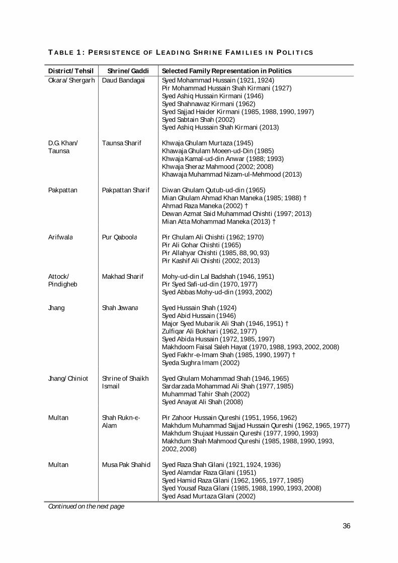
36
T A B L E 1 : P E R S I S T E N C E O F L E A D I N G S H R I N E F A M I L I E S I N P O L I T I C S
District/Tehsil Shrine/Gaddi Selected Family Representation in Politics Okara/Shergarh Daud Bandagai Syed Mohammad Hussain (1921, 1924)
Pir Mohammad Hussain Shah Kirmani (1927) Syed Ashiq Hussain Kirmani (1946) Syed Shahnawaz Kirmani (1962) Syed Sajjad Haider Kirmani (1985, 1988, 1990, 1997) Syed Sabtain Shah (2002) Syed Ashiq Hussain Shah Kirmani (2013)
D.G. Khan/ Taunsa
Taunsa Sharif Khwaja Ghulam Murtaza (1945) Khawaja Ghulam Moeen-ud-Din (1985) Khwaja Kamal-ud-din Anwar (1988; 1993) Khwaja Sheraz Mahmood (2002; 2008) Khawaja Muhammad Nizam-ul-Mehmood (2013)
Pakpattan
Pakpattan Sharif
Diwan Ghulam Qutub-ud-din (1965) Mian Ghulam Ahmad Khan Maneka (1985; 1988) † Ahmad Raza Maneka (2002) † Dewan Azmat Said Muhammad Chishti (1997; 2013) Mian Atta Mohammad Maneka (2013) †
Arifwala
Pur Qaboola Pir Ghulam Ali Chishti (1962; 1970) Pir Ali Gohar Chishti (1965) Pir Allahyar Chishti (1985, 88, 90, 93) Pir Kashif Ali Chishti (2002; 2013)
Attock/ Pindigheb
Makhad Sharif Mohy-ud-din Lal Badshah (1946, 1951) Pir Syed Safi-ud-din (1970, 1977) Syed Abbas Mohy-ud-din (1993, 2002)
Jhang Shah Jewana Syed Hussain Shah (1924)
Syed Abid Hussain (1946) Major Syed Mubarik Ali Shah (1946, 1951) † Zulfiqar Ali Bokhari (1962, 1977) Syed Abida Hussain (1972, 1985, 1997) Makhdoom Faisal Saleh Hayat (1970, 1988, 1993, 2002, 2008) Syed Fakhr-e-Imam Shah (1985, 1990, 1997) † Syeda Sughra Imam (2002)
Jhang/Chiniot Shrine of Shaikh
Ismail Syed Ghulam Mohammad Shah (1946, 1965) Sardarzada Mohammad Ali Shah (1977, 1985) Muhammad Tahir Shah (2002) Syed Anayat Ali Shah (2008)
Multan Shah Rukn-e-
Alam Pir Zahoor Hussain Qureshi (1951, 1956, 1962) Makhdum Muhammad Sajjad Hussain Qureshi (1962, 1965, 1977) Makhdum Shujaat Hussain Qureshi (1977, 1990, 1993) Makhdum Shah Mahmood Qureshi (1985, 1988, 1990, 1993, 2002, 2008)
Multan Musa Pak Shahid Syed Raza Shah Gilani (1921, 1924, 1936)
Syed Alamdar Raza Gilani (1951) Syed Hamid Raza Gilani (1962, 1965, 1977, 1985) Syed Yousaf Raza Gilani (1985, 1988, 1990, 1993, 2008) Syed Asad Murtaza Gilani (2002)
Continued on the next page
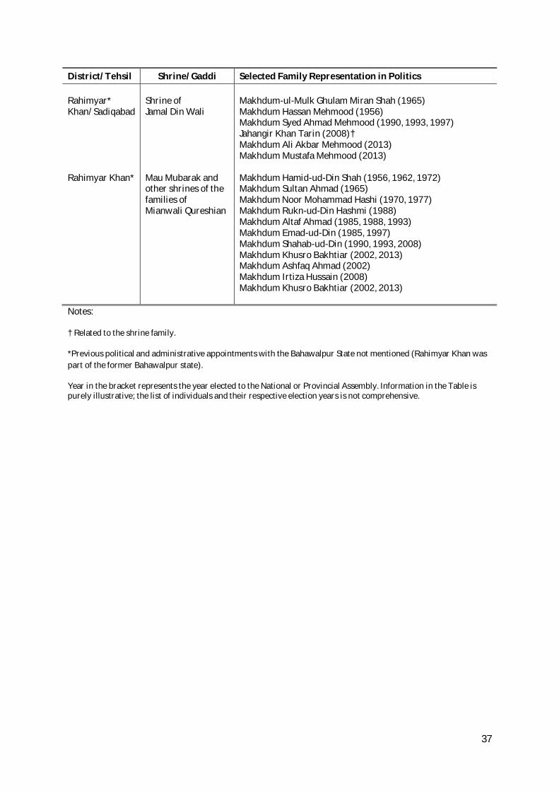
37
District/Tehsil Shrine/Gaddi Selected Family Representation in Politics Rahimyar* Khan/Sadiqabad
Shrine of Jamal Din Wali
Makhdum-ul-Mulk Ghulam Miran Shah (1965) Makhdum Hassan Mehmood (1956) Makhdum Syed Ahmad Mehmood (1990, 1993, 1997) Jahangir Khan Tarin (2008)† Makhdum Ali Akbar Mehmood (2013) Makhdum Mustafa Mehmood (2013)
Rahimyar Khan* Mau Mubarak and other shrines of the families of Mianwali Qureshian
Makhdum Hamid-ud-Din Shah (1956, 1962, 1972) Makhdum Sultan Ahmad (1965) Makhdum Noor Mohammad Hashi (1970, 1977) Makhdum Rukn-ud-Din Hashmi (1988) Makhdum Altaf Ahmad (1985, 1988, 1993) Makhdum Emad-ud-Din (1985, 1997) Makhdum Shahab-ud-Din (1990, 1993, 2008) Makhdum Khusro Bakhtiar (2002, 2013) Makhdum Ashfaq Ahmad (2002) Makhdum Irtiza Hussain (2008) Makhdum Khusro Bakhtiar (2002, 2013)
Notes:
† Related to the shrine family.
*Previous political and administrative appointments with the Bahawalpur State not mentioned (Rahimyar Khan was part of the former Bahawalpur state).
Year in the bracket represents the year elected to the National or Provincial Assembly. Information in the Table is purely illustrative; the list of individuals and their respective election years is not comprehensive.
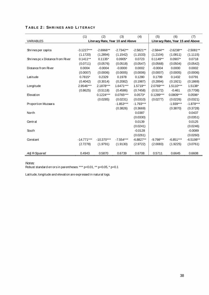
38
T A B L E 2 : S H R I N E S A N D L I T E R A C Y
(1) (2) (3) (4) (5) (6) (7) VARIABLES Literacy Rate, Year 10 and Above Literacy Rate, Year 15 and Above
Shrines per capita -3.1227*** -2.6966** -2.7342** -2.5821** -2.5844** -2.6238** -2.5081**
(1.1720) (1.2894) (1.1542) (1.1533) (1.2104) (1.0811) (1.1115)
Shrines pc x Distance from River 0.1411** 0.1135* 0.0905* 0.0723 0.1149** 0.0907* 0.0718
(0.0711) (0.0576) (0.0518) (0.0547) (0.0568) (0.0504) (0.0542)
Distance from River 0.0004 -0.0004 -0.0000 0.0002 -0.0004 0.0000 0.0002
(0.0007) (0.0006) (0.0005) (0.0006) (0.0007) (0.0005) (0.0006)
Latitude 0.7815* 0.2329 0.1978 0.1280 0.1799 0.1432 0.0791
(0.4042) (0.3014) (0.2082) (0.1987) (0.2894) (0.1921) (0.1869)
Longitude 2.9546*** 2.1878*** 1.6471*** 1.5719** 2.0769*** 1.5110*** 1.5138*
(0.8625) (0.5118) (0.4586) (0.7458) (0.5172) -0.461 (0.7708)
Elevation
0.1224*** 0.0765*** 0.0573* 0.1289*** 0.0809*** 0.0596*
(0.0285) (0.0231) (0.0310) (0.0277) (0.0226) (0.0321)
Proportion Muzaara
-1.853*** -1.793*** -1.939*** -1.878***
(0.3826) (0.3669) (0.3870) (0.3728)
North
0.0387
0.0437
(0.0330)
(0.0351)
Central
0.0139
0.0125
(0.0241)
(0.0246)
South
-0.0128
-0.0089
(0.0261)
(0.0260)
Constant -14.771*** -10.370*** -7.554*** -6.8827** -9.798*** -6.851*** -6.5198**
(2.7278) (1.9791) (1.9130) (2.9722) (2.0083) (1.9225) (3.0761)
Adj R-Squared 0.4943 0.5870 0.6739 0.6708 0.5711 0.6645 0.6608 Notes: Robust standard errors in parentheses: *** p<0.01, ** p<0.05, * p<0.1 Latitude, longitude and elevation are expressed in natural logs.
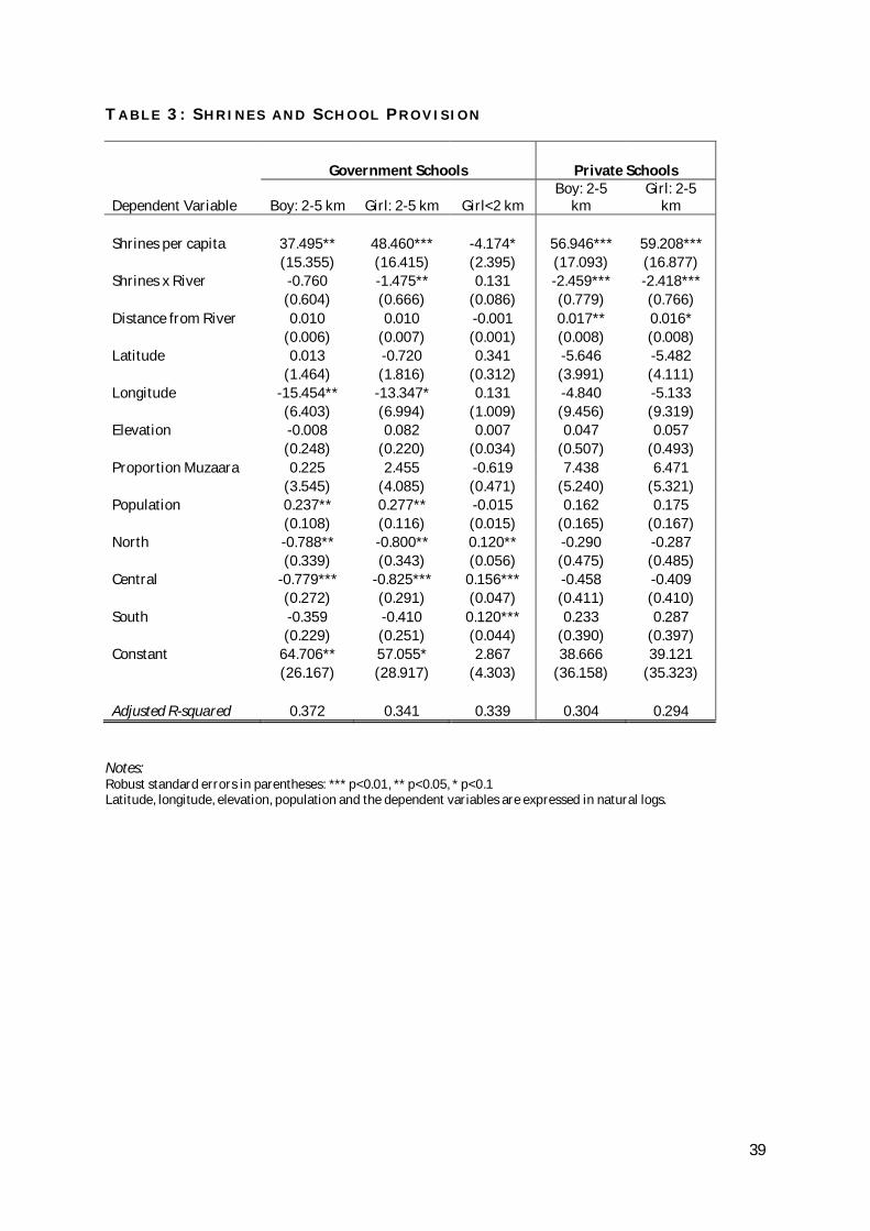
39
T A B L E 3 : S H R I N E S A N D S C H O O L P R O V I S I O N
Government Schools Private Schools
Dependent Variable Boy: 2-5 km Girl: 2-5 km Girl<2 km Boy: 2-5
km Girl: 2-5
km Shrines per capita 37.495** 48.460*** -4.174* 56.946*** 59.208***
(15.355) (16.415) (2.395) (17.093) (16.877)
Shrines x River -0.760 -1.475** 0.131 -2.459*** -2.418***
(0.604) (0.666) (0.086) (0.779) (0.766)
Distance from River 0.010 0.010 -0.001 0.017** 0.016*
(0.006) (0.007) (0.001) (0.008) (0.008)
Latitude 0.013 -0.720 0.341 -5.646 -5.482
(1.464) (1.816) (0.312) (3.991) (4.111)
Longitude -15.454** -13.347* 0.131 -4.840 -5.133
(6.403) (6.994) (1.009) (9.456) (9.319)
Elevation -0.008 0.082 0.007 0.047 0.057
(0.248) (0.220) (0.034) (0.507) (0.493)
Proportion Muzaara 0.225 2.455 -0.619 7.438 6.471
(3.545) (4.085) (0.471) (5.240) (5.321)
Population 0.237** 0.277** -0.015 0.162 0.175
(0.108) (0.116) (0.015) (0.165) (0.167)
North -0.788** -0.800** 0.120** -0.290 -0.287
(0.339) (0.343) (0.056) (0.475) (0.485)
Central -0.779*** -0.825*** 0.156*** -0.458 -0.409
(0.272) (0.291) (0.047) (0.411) (0.410)
South -0.359 -0.410 0.120*** 0.233 0.287
(0.229) (0.251) (0.044) (0.390) (0.397)
Constant 64.706** 57.055* 2.867 38.666 39.121
(26.167) (28.917) (4.303) (36.158) (35.323)
Adjusted R-squared 0.372 0.341 0.339 0.304 0.294
Notes: Robust standard errors in parentheses: *** p<0.01, ** p<0.05, * p<0.1 Latitude, longitude, elevation, population and the dependent variables are expressed in natural logs.
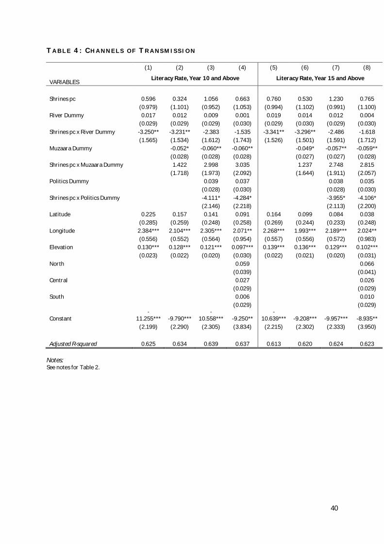
40
T A B L E 4 : C H A N N E L S O F T R A N S M I S S I O N
(1) (2) (3) (4) (5) (6) (7) (8)
VARIABLES Literacy Rate, Year 10 and Above Literacy Rate, Year 15 and Above
Shrines pc 0.596 0.324 1.056 0.663 0.760 0.530 1.230 0.765
(0.979) (1.101) (0.952) (1.053) (0.994) (1.102) (0.991) (1.100)
River Dummy 0.017 0.012 0.009 0.001 0.019 0.014 0.012 0.004
(0.029) (0.029) (0.029) (0.030) (0.029) (0.030) (0.029) (0.030)
Shrines pc x River Dummy -3.250** -3.231** -2.383 -1.535 -3.341** -3.296** -2.486 -1.618
(1.565) (1.534) (1.612) (1.743) (1.526) (1.501) (1.591) (1.712)
Muzaara Dummy
-0.052* -0.060** -0.060**
-0.049* -0.057** -0.059**
(0.028) (0.028) (0.028)
(0.027) (0.027) (0.028)
Shrines pc x Muzaara Dummy
1.422 2.998 3.035
1.237 2.748 2.815
(1.718) (1.973) (2.092)
(1.644) (1.911) (2.057)
Politics Dummy
0.039 0.037
0.038 0.035
(0.028) (0.030)
(0.028) (0.030)
Shrines pc x Politics Dummy
-4.111* -4.284*
-3.955* -4.106*
(2.146) (2.218)
(2.113) (2.200)
Latitude 0.225 0.157 0.141 0.091 0.164 0.099 0.084 0.038
(0.285) (0.259) (0.248) (0.258) (0.269) (0.244) (0.233) (0.248)
Longitude 2.384*** 2.104*** 2.305*** 2.071** 2.268*** 1.993*** 2.189*** 2.024**
(0.556) (0.552) (0.564) (0.954) (0.557) (0.556) (0.572) (0.983)
Elevation 0.130*** 0.128*** 0.121*** 0.097*** 0.139*** 0.136*** 0.129*** 0.102***
(0.023) (0.022) (0.020) (0.030) (0.022) (0.021) (0.020) (0.031)
North
0.059
0.066
(0.039)
(0.041)
Central
0.027
0.026
(0.029)
(0.029)
South
0.006
0.010
(0.029)
(0.029)
Constant -
11.255*** -9.790*** -
10.558*** -9.250** -
10.639*** -9.208*** -9.957*** -8.935**
(2.199) (2.290) (2.305) (3.834) (2.215) (2.302) (2.333) (3.950)
Adjusted R-squared 0.625 0.634 0.639 0.637 0.613 0.620 0.624 0.623 Notes: See notes for Table 2.
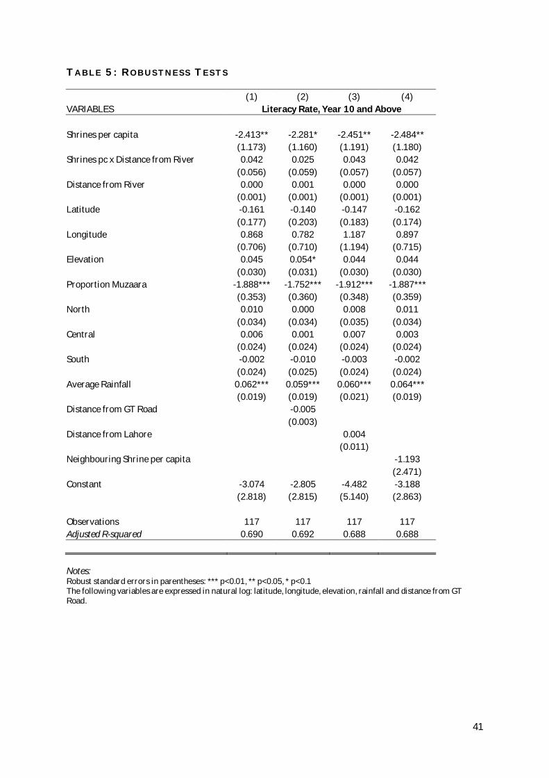
41
T A B L E 5 : R O B U S T N E S S T E S T S
(1) (2) (3) (4) VARIABLES Literacy Rate, Year 10 and Above Shrines per capita -2.413** -2.281* -2.451** -2.484**
(1.173) (1.160) (1.191) (1.180)
Shrines pc x Distance from River 0.042 0.025 0.043 0.042
(0.056) (0.059) (0.057) (0.057)
Distance from River 0.000 0.001 0.000 0.000
(0.001) (0.001) (0.001) (0.001)
Latitude -0.161 -0.140 -0.147 -0.162
(0.177) (0.203) (0.183) (0.174)
Longitude 0.868 0.782 1.187 0.897
(0.706) (0.710) (1.194) (0.715)
Elevation 0.045 0.054* 0.044 0.044
(0.030) (0.031) (0.030) (0.030)
Proportion Muzaara -1.888*** -1.752*** -1.912*** -1.887***
(0.353) (0.360) (0.348) (0.359)
North 0.010 0.000 0.008 0.011
(0.034) (0.034) (0.035) (0.034)
Central 0.006 0.001 0.007 0.003
(0.024) (0.024) (0.024) (0.024)
South -0.002 -0.010 -0.003 -0.002
(0.024) (0.025) (0.024) (0.024)
Average Rainfall 0.062*** 0.059*** 0.060*** 0.064***
(0.019) (0.019) (0.021) (0.019)
Distance from GT Road
-0.005
(0.003)
Distance from Lahore
0.004
(0.011)
Neighbouring Shrine per capita
-1.193
(2.471)
Constant -3.074 -2.805 -4.482 -3.188
(2.818) (2.815) (5.140) (2.863)
Observations 117 117 117 117 Adjusted R-squared 0.690 0.692 0.688 0.688 Notes: Robust standard errors in parentheses: *** p<0.01, ** p<0.05, * p<0.1 The following variables are expressed in natural log: latitude, longitude, elevation, rainfall and distance from GT Road.
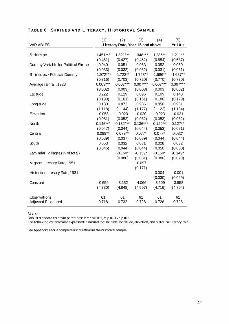
42
T A B L E 6 : S H R I N E S A N D L I T E R A C Y , H I S T O R I C A L S A M P L E
(1) (2) (3) (4) (5) VARIABLES Literacy Rate, Year 15 and above Yr 10 + Shrines pc 1.451*** 1.321*** 1.348*** 1.286** 1.211**
(0.461) (0.427) (0.452) (0.554) (0.537)
Dummy Variable for Political Shrines 0.040 0.051 0.053 0.052 0.050
(0.033) (0.032) (0.032) (0.031) (0.031)
Shrines pc x Political Dummy -1.972*** -1.722** -1.728** -1.686** -1.687**
(0.716) (0.703) (0.720) (0.770) (0.770)
Average rainfall, 1923 0.009*** 0.007*** 0.007*** 0.007*** 0.007***
(0.002) (0.003) (0.003) (0.003) (0.002)
Latitude 0.222 0.119 0.096 0.109 0.143
(0.199) (0.161) (0.151) (0.180) (0.179)
Longitude 0.130 0.872 0.986 0.850 0.931
(1.118) (1.144) (1.177) (1.122) (1.134)
Elevation -0.058 -0.023 -0.020 -0.023 -0.021
(0.051) (0.052) (0.052) (0.053) (0.052)
North 0.145*** 0.132*** 0.136*** 0.129** 0.127**
(0.047) (0.044) (0.044) (0.053) (0.051)
Central 0.089** 0.079** 0.077* 0.077* 0.082*
(0.039) (0.037) (0.039) (0.044) (0.044)
South 0.053 0.032 0.031 0.028 0.032
(0.046) (0.044) (0.044) (0.050) (0.050)
Zamindari Villages (% of total)
-0.160* -0.159* -0.159* -0.149*
(0.080) (0.081) (0.080) (0.079)
Migrant Literacy Rate, 1951
-0.097
(0.171)
Historical Literacy Rate, 1931
0.004 -0.001
(0.030) (0.029)
Constant -0.659 -3.652 -4.066 -3.509 -3.958
(4.730) (4.848) (4.997) (4.719) (4.794)
Observations 61 61 61 61 61 Adjusted R-squared 0.718 0.732 0.728 0.726 0.726
Notes: Robust standard errors in parentheses: *** p<0.01, ** p<0.05, * p<0.1 The following variables are expressed in natural log: latitude, longitude, elevation, and historical literacy rate. See Appendix 4 for a complete list of tehsils in the historical sample.
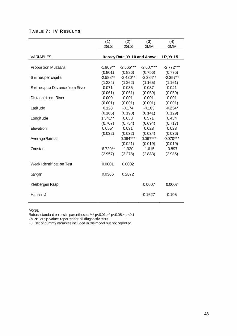
43
T A B L E 7 : I V R E S U L T S
(1) (2) (3) (4)
2SLS 2SLS GMM GMM
VARIABLES Literacy Rate, Yr 10 and Above LR, Yr 15
Proportion Muzaara -1.909** -2.565*** -2.607*** -2.772***
(0.801) (0.836) (0.756) (0.775)
Shrines per capita -2.588** -2.430** -2.384** -2.357**
(1.284) (1.262) (1.165) (1.161)
Shrines pc x Distance from River 0.071 0.035 0.037 0.041
(0.061) (0.061) (0.059) (0.059)
Distance from River 0.000 0.001 0.001 0.001
(0.001) (0.001) (0.001) (0.001)
Latitude 0.128 -0.174 -0.183 -0.234*
(0.165) (0.190) (0.141) (0.129)
Longitude 1.541** 0.633 0.571 0.434
(0.707) (0.754) (0.694) (0.717)
Elevation 0.055* 0.031 0.028 0.028
(0.032) (0.032) (0.034) (0.036)
Average Rainfall
0.064*** 0.067*** 0.070***
(0.021) (0.019) (0.019)
Constant -6.729** -1.920 -1.615 -0.897
(2.957) (3.278) (2.883) (2.985)
Weak Identification Test 0.0001 0.0002
Sargan 0.0366 0.2872
Kleibergen Paap
0.0007 0.0007
Hansen J
0.1627 0.105
Notes: Robust standard errors in parentheses: *** p<0.01, ** p<0.05, * p<0.1 Chi-square p-values reported for all diagnostic tests. Full set of dummy variables included in the model but not reported.

44
T A B L E 8 : D E T E R M I N A N T S O F P O L I T I C A L S E L E C T I O N
( P R O B I T M O D E L S )
(1) (2) (3) (4)
VARIABLES Dummy Variable for Political Shrines
Shrines mentioned in PDG 0.084*** 0.054** 0.067*** 0.058**
(0.027) (0.027) (0.026) (0.026)
Distance from River
-0.001 -0.002 -0.003
(0.003) (0.003) (0.003)
Latitude
-0.358 -0.836 -1.005
(0.909) (0.975) (0.976)
Longitude
2.948 -6.517 -6.110
(3.752) (4.783) (4.843)
Elevation
-0.655*** -0.317* -0.286*
(0.222) (0.170) (0.156)
North
0.416* 0.509**
(0.249) (0.231)
Central
0.474*** 0.469***
(0.171) (0.174)
South
0.437** 0.395**
(0.179) (0.181)
Cultivated area, 25 acres and above
1.608*
(0.898)
Chi-Square test 0.446 0.552 0.645 0.511 Pseudo R2 0.091 0.211 0.241 0.261
Notes: Robust standard errors in parentheses: *** p<0.01, ** p<0.05, * p<0.1 The sample consists of 118 tehsils (see Appendix 3 for a complete list)
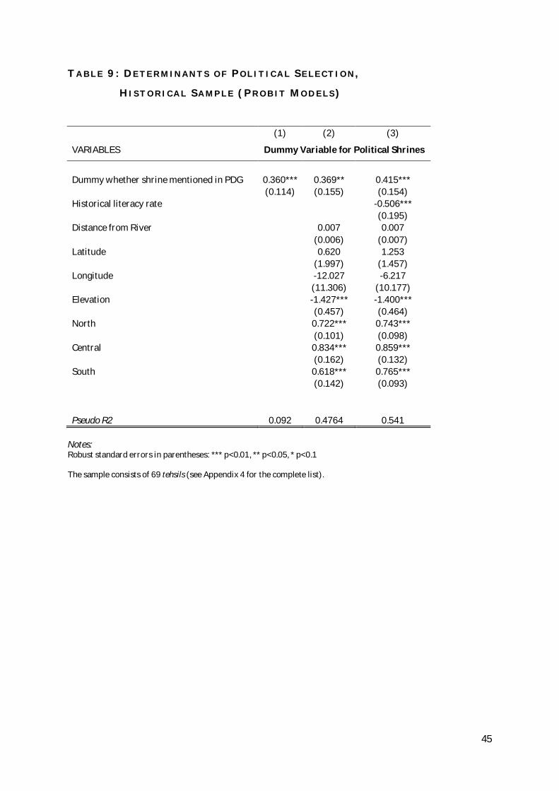
45
T A B L E 9 : D E T E R M I N A N T S O F P O L I T I C A L S E L E C T I O N ,
H I S T O R I C A L S A M P L E ( P R O B I T M O D E L S )
(1) (2) (3)
VARIABLES Dummy Variable for Political Shrines
Dummy whether shrine mentioned in PDG 0.360*** 0.369** 0.415***
(0.114) (0.155) (0.154)
Historical literacy rate
-0.506***
(0.195)
Distance from River
0.007 0.007
(0.006) (0.007)
Latitude
0.620 1.253
(1.997) (1.457)
Longitude
-12.027 -6.217
(11.306) (10.177)
Elevation
-1.427*** -1.400***
(0.457) (0.464)
North
0.722*** 0.743***
(0.101) (0.098)
Central
0.834*** 0.859***
(0.162) (0.132)
South
0.618*** 0.765***
(0.142) (0.093)
Pseudo R2 0.092 0.4764 0.541
Notes: Robust standard errors in parentheses: *** p<0.01, ** p<0.05, * p<0.1 The sample consists of 69 tehsils (see Appendix 4 for the complete list).

46
F I G U R E S 2 A N D 3
Ahmadpur Sial
Ahmedpur East
Ali pur
Arifwala
Attock
Bahawalnagar
Bahawalpur
Bhakkar
Bhalwal
Burewala
Chak Jhumra Town
Chakwal
Chichawatni
Chinniot
Chishtian
Choa Saidan Shah
Choubara
ChunianDG Khan
Darya KhanDaska
Depalpur Dunya PurEssa Khel
Faisalabad Fateh JangFerozewala
Fort Abbas
Gojra
Gujjar Khan TownGujranwala
Gujrat
Hafizabad
Haroonabad
Hasanabdal
Hasilpur
Hazro
Jahanian
Jalalpur Pirwala Town
Jampur
Jand
Jaranwala Town
Jatoi
Jhang
Jhelum
Kabirwala
Kahuta Town
Kallur Kot
Kamalia
Kamoke Town
Karor Lal Esan
Kasur
Kehror PaccaKhairpur Tamewali
Khanewal
Khanpur
KharianKhushab
Kot Addu
Kot MominLahore
LayyahLiaqatpur
LodhranMailsi
MalakwalMandi BahauddinMankera
Mian Channu
Mianwali
Minchinabad
Multan
Muridke
Murree Town
Muzaffargarh
Nankana Sahib
Narowal Noorpur ThalNowshera Virkan TownOkara
Pakpattan
Pasrur
Pattoki
Phalia
Pind Dadan Khan
Pindi Bhattian
Pindigheb
Piplan
RY KhanRajanpur
Rawalpindi
Renala Khurd
Sadiqabad
Safdarabad
Sahiwal
Sahiwal2 SambrialSangla Hill
Sara-e-Alamgir
Sargodha
Shah Kot
Shahpur Shakargarh
Sharaqpur Sharif
Sheikhupura
Shorkot
Shujabad Town
SialkotSillanwali
Sumundri Town
TT Singh
Talagang
Tandlianwala Town
Taunsa
Taxila Town
Vehari
Wazirabad Town
Yazman
01
23
4
0 .05 .1 .15prop_muzaara
ln_girlprivm5km Fitted values
Ahmadpur Sial
Ahmedpur East
Ali pur
Arifwala
Attock
Bahawalnagar
Bahawalpur
Bhakkar
Bhalwal
Burewala
Chak Jhumra Town
Chakwal
Chichawatni
Chinniot
Chishtian
Choa Saidan Shah
Choubara
ChunianDG Khan
Darya KhanDaska
Depalpur Dunya PurEssa Khel
Faisalabad Fateh JangFerozewala
Fort Abbas
Gojra
Gujjar Khan TownGujranwala
Gujrat
Hafizabad
Haroonabad
Hasanabdal
Hasilpur
Hazro
Jahanian
Jalalpur Pirwala Town
Jampur
Jand
Jaranwala Town
Jatoi
Jhang
Jhelum
Kabirwala
Kahuta Town
Kallur Kot
Kamalia
Kamoke Town
Karor Lal Esan
Kasur
Kehror PaccaKhairpur Tamewali
Khanewal
Khanpur
KharianKhushab
Kot Addu
Kot MominLahore
LayyahLiaqatpur
LodhranMailsi
MalakwalMandi BahauddinMankera
Mian Channu
Mianwali
Minchinabad
Multan
Muridke
Murree Town
Muzaffargarh
Nankana Sahib
Narowal Noorpur ThalNowshera Virkan TownOkara
Pakpattan
Pasrur
Pattoki
Phalia
Pind Dadan Khan
Pindi Bhattian
Pindigheb
Piplan
RY Khan
Rajanpur
Rawalpindi
Renala Khurd
Sadiqabad
Safdarabad
Sahiwal
Sahiwal2 SambrialSangla Hill
Sara-e-Alamgir
Sargodha
Shah Kot
Shahpur Shakargarh
Sharaqpur Sharif
Sheikhupura
Shorkot
Shujabad Town
SialkotSillanwali
Sumundri Town
TT Singh
Talagang
Tandlianwala Town
Taunsa
Taxila Town
Vehari
Wazirabad Town
Yazman
01
23
4
0 .05 .1 .15prop_muzaara
ln_boyprivm5km Fitted values
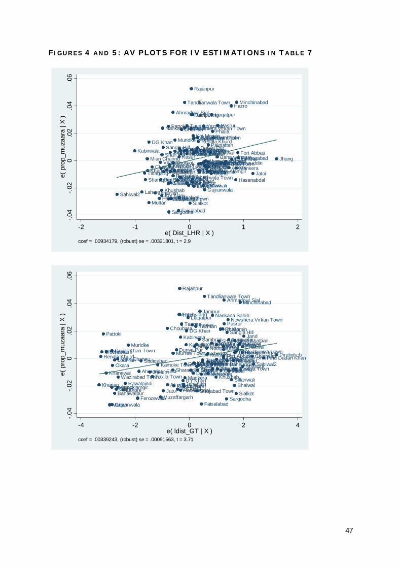
47
F I G U R E S 4 A N D 5 : A V P L O T S F O R I V E S T I M A T I O N S I N T A B L E 7
Sahiwal2
Kabirwala
Lahore
TalagangSharaqpur Sharif
Mian Channu
Khanewal
Multan
DG Khan
Chakwal
JahanianFerozewala
Vehari
Pind Dadan Khan
Chak Jhumra Town
KhushabKot Addu
Shah Kot
Nankana Sahib
Sangla Hill
Choa Saidan ShahJaranwala Town
Mianwali
Pattoki
Muzaffargarh
Sargodha
Kallur KotKamoke Town
Jand
Jhelum
Sheikhupura
Shujabad Town
Ahmadpur Sial
Shorkot
PindighebPiplan
Muridke
Karor Lal Esan
Shahpur
Faisalabad
Kasur
Bhalwal
Kamalia
Safdarabad
BurewalaKhairpur Tamewali
Jalalpur Pirwala Town
Chunian
Lodhran
Tandlianwala Town
Choubara
Sumundri Town
Bahawalpur
Noorpur Thal
Taunsa
Kahuta Town
Sialkot
Nowshera Virkan Town
Fateh Jang
Rajanpur
RY Khan
Pindi Bhattian
MailsiAli pur
Jampur
Sadiqabad
Kot MominSahiwal
Layyah
Chichawatni
HasilpurMurree Town
Gujjar Khan Town
Dunya PurRenala Khurd
HafizabadTT SinghRawalpindiDarya KhanKehror Pacca
Sillanwali
Wazirabad TownDepalpur
Yazman
Okara
Gujranwala
GojraChishtianAhmedpur EastKhanpurBhakkarDaska
Arifwala
Pakpattan
KharianSara-e-Alamgir
Malakwal
Gujrat
Liaqatpur
PhaliaSambrial
Chinniot
Bahawalnagar
Pasrur
Mandi BahauddinTaxila TownNarowalAttock
Hazro
Essa Khel
Hasanabdal
Mankera
Minchinabad
Fort AbbasHaroonabad
Jatoi
Jhang
-.04
-.02
0.0
2.0
4.0
6e(
pro
p_m
uzaa
ra |
X )
-2 -1 0 1 2e( Dist_LHR | X )
coef = .00934179, (robust) se = .00321801, t = 2.9
Kharian
Renala KhurdChichawatni
Pattoki
Khanewal
Sahiwal
Multan
Sara-e-Alamgir
Gujjar Khan Town
Gujranwala
Okara
Bahawalpur
Lodhran
Gujrat
Mian Channu
Attock
Wazirabad Town
LahoreRawalpindi
Muridke
Ferozewala
Ahmedpur East
Sadiqabad
JhelumTaxila Town
Kamoke Town
MuzaffargarhJatoi
Choubara
Ali pur
Sharaqpur Sharif
Murree Town
Kahuta Town
Dunya Pur
Kot Addu
Fateh Jang
Rajanpur
Hazro
Hasanabdal
Kabirwala
Taunsa
RY KhanJahanianLayyahMankera
Depalpur
Kamalia
DG Khan
Liaqatpur
TT Singh
Chunian
Daska
Kehror Pacca
Sumundri Town
Darya Khan
Yazman
Karor Lal Esan
Gojra
Shujabad Town
BhakkarEssa Khel
Sambrial
Jampur
Sheikhupura
Faisalabad
ArifwalaJaranwala Town
Tandlianwala Town
Noorpur ThalKallur KotShorkot
Mianwali
Piplan
Pakpattan
Mandi Bahauddin
Nankana Sahib
SafdarabadKhanpur
Khushab
Khairpur Tamewali
Hafizabad
Jalalpur Pirwala Town
Shah Kot
Kot Momin
Chinniot
Phalia
Fort Abbas
KasurMalakwalChoa Saidan Shah
Ahmadpur Sial
Pasrur
Sargodha
Sangla Hill
Haroonabad
Nowshera Virkan Town
Burewala
Mailsi
Sillanwali
Narowal
Bhalwal
Pindi Bhattian
Talagang
Jhang
Chak Jhumra Town
Sialkot
VehariHasilpur
Minchinabad
BahawalnagarChakwal
Shahpur
Jand
ChishtianSahiwal2
Pind Dadan KhanPindigheb
-.04
-.02
0.0
2.0
4.0
6e(
pro
p_m
uzaa
ra |
X )
-4 -2 0 2 4e( ldist_GT | X )
coef = .00339243, (robust) se = .00091563, t = 3.71
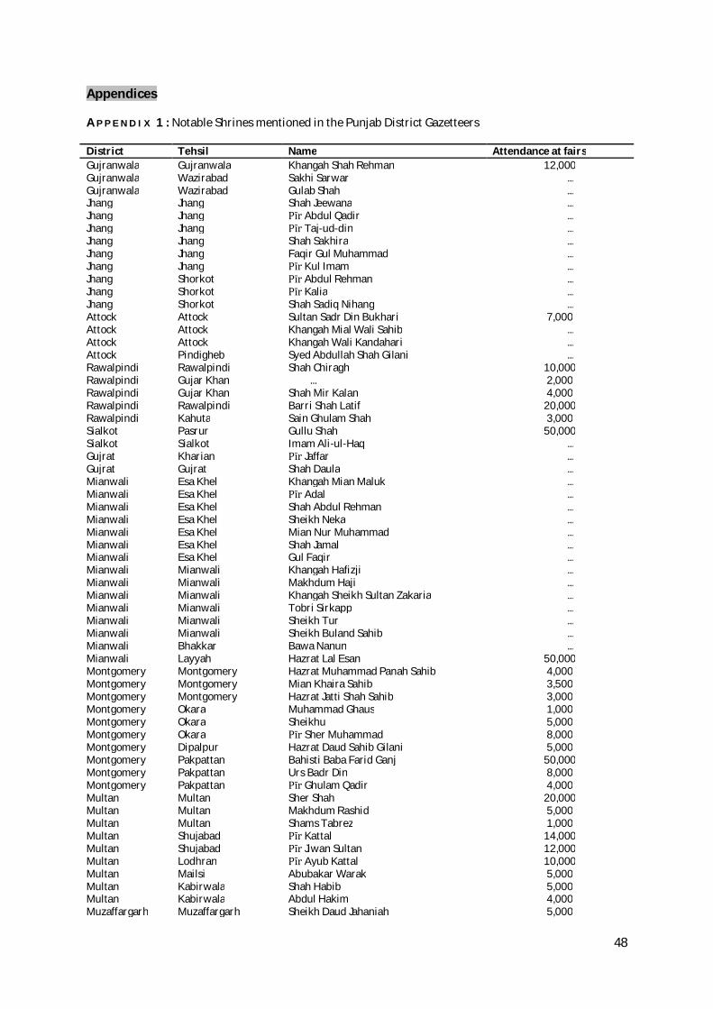
48
Appendices
A P P E N D I X 1 : Notable Shrines mentioned in the Punjab District Gazetteers
District Tehsil Name Attendance at fairs Gujranwala Gujranwala Khangah Shah Rehman 12,000 Gujranwala Wazirabad Sakhi Sarwar ... Gujranwala Wazirabad Gulab Shah ... Jhang Jhang Shah Jeewana ... Jhang Jhang Pīr Abdul Qadir ... Jhang Jhang Pīr Taj-ud-din ... Jhang Jhang Shah Sakhira ... Jhang Jhang Faqir Gul Muhammad ... Jhang Jhang Pīr Kul Imam ... Jhang Shorkot Pīr Abdul Rehman ... Jhang Shorkot Pīr Kalia ... Jhang Shorkot Shah Sadiq Nihang ... Attock Attock Sultan Sadr Din Bukhari 7,000 Attock Attock Khangah Mial Wali Sahib ... Attock Attock Khangah Wali Kandahari ... Attock Pindigheb Syed Abdullah Shah Gilani ... Rawalpindi Rawalpindi Shah Chiragh 10,000 Rawalpindi Gujar Khan ... 2,000 Rawalpindi Gujar Khan Shah Mir Kalan 4,000 Rawalpindi Rawalpindi Barri Shah Latif 20,000 Rawalpindi Kahuta Sain Ghulam Shah 3,000 Sialkot Pasrur Gullu Shah 50,000 Sialkot Sialkot Imam Ali-ul-Haq ... Gujrat Kharian Pīr Jaffar ... Gujrat Gujrat Shah Daula ... Mianwali Esa Khel Khangah Mian Maluk ... Mianwali Esa Khel Pīr Adal ... Mianwali Esa Khel Shah Abdul Rehman ... Mianwali Esa Khel Sheikh Neka ... Mianwali Esa Khel Mian Nur Muhammad ... Mianwali Esa Khel Shah Jamal ... Mianwali Esa Khel Gul Faqir ... Mianwali Mianwali Khangah Hafizji ... Mianwali Mianwali Makhdum Haji ... Mianwali Mianwali Khangah Sheikh Sultan Zakaria ... Mianwali Mianwali Tobri Sirkapp ... Mianwali Mianwali Sheikh Tur ... Mianwali Mianwali Sheikh Buland Sahib ... Mianwali Bhakkar Bawa Nanun ... Mianwali Layyah Hazrat Lal Esan 50,000 Montgomery Montgomery Hazrat Muhammad Panah Sahib 4,000 Montgomery Montgomery Mian Khaira Sahib 3,500 Montgomery Montgomery Hazrat Jatti Shah Sahib 3,000 Montgomery Okara Muhammad Ghaus 1,000 Montgomery Okara Sheikhu 5,000 Montgomery Okara Pīr Sher Muhammad 8,000 Montgomery Dipalpur Hazrat Daud Sahib Gilani 5,000 Montgomery Pakpattan Bahisti Baba Farid Ganj 50,000 Montgomery Pakpattan Urs Badr Din 8,000 Montgomery Pakpattan Pīr Ghulam Qadir 4,000 Multan Multan Sher Shah 20,000 Multan Multan Makhdum Rashid 5,000 Multan Multan Shams Tabrez 1,000 Multan Shujabad Pīr Kattal 14,000 Multan Shujabad Pīr Jiwan Sultan 12,000 Multan Lodhran Pīr Ayub Kattal 10,000 Multan Mailsi Abubakar Warak 5,000 Multan Kabirwala Shah Habib 5,000 Multan Kabirwala Abdul Hakim 4,000 Muzaffargarh Muzaffargarh Sheikh Daud Jahaniah 5,000
49
Muzaffargarh Muzaffargarh Bhagga Sher 2,000 Muzaffargarh Muzaffargarh Miran Hayat ... Muzaffargarh Muzaffargarh Dedha Lal 2,500 Muzaffargarh Muzaffargarh Musan Shah 5,000 Muzaffargarh Muzaffargarh Muhib Jahaniah 3,000 Muzaffargarh Muzaffargarh Pīr Ali, Pīr Kamal, Pīr Fateh Darya 2,500 Muzaffargarh Muzaffargarh Din Shah 2,500 Muzaffargarh Kot Addu Din Panah ... Muzaffargarh Kot Addu Syed Isa Abdul Wahab ... Muzaffargarh Kot Addu Nur Shah 2,000 Muzaffargarh Kot Addu Sheikh Pallia ... Muzaffargarh Kot Addu Haji Ishaq ... Muzaffargarh Alipur Alam Pīr 5,000 Bahawalpur Minchinabad Pīr Muhammad 5,000 Bahawalpur Minchinabad Raushan Din (Naushahi) 3,000 Bahawalpur Khaipur Khwaja Nur Muhammad Sahib 7,000 Bahawalpur Khaipur Shauk Elahi Sahib 2,000 Bahawalpur Khaipur Sheikh Wahan 8,000 Bahawalpur Khaipur Khandu Shahid ... Bahawalpur Khaipur Jamaldi Shahid ... Bahawalpur Khaipur Bhindwala Sahib ... Bahawalpur Khaipur Mari Shauq Shah ... Bahawalpur Khaipur Taj-ud-Din Chishti ... Bahawalpur Khaipur Maulvi Khuda Bakshs ... Bahawalpur Khaipur Pīr Abdul Khaliq ... Bahawalpur Khaipur Lal Sohanra ... Bahawalpur Bahawalpur Ali Ashab ... Bahawalpur Bahawalpur Garib Shah, Chhatan Lal 2,000 Bahawalpur Bahawalpur Sahib-us-Sair 8,000 Bahawalpur Bahawalpur Sambat 3,000 Bahawalpur Bahawalpur Zahir Pīr 1,000 Bahawalpur Bahawalpur Channar Pīr ... Bahawalpur Ahmadpur Sher Shah Syed Jalal 50,000 Bahawalpur Ahmadpur Muhammad Ghaus ... Bahawalpur Ahmadpur Ahmad Kabir ... Bahawalpur Ahmadpur Makhdum Jahanian ... Bahawalpur Ahmadpur Rajan Qattal ... Bahawalpur Ahmadpur Mahmud Nasir-ud-Din ... Bahawalpur Ahmadpur Sheikh Syed Fazl-ud-Din ... Bahawalpur Ahmadpur Sheikh Syed Abd-ul-Malik ... Bahawalpur Ahmadpur Pīr Khusro ... Bahawalpur Ahmadpur Jamal Darwesh ... Bahawalpur Ahmadpur Pīr Mina ... Bahawalpur Ahmadpur Khalifa Fateh ... Bahawalpur Ahmadpur Haji Syed Sadr-ud-Din ... Bahawalpur Ahmadpur Hassan Darya ... Bahawalpur Khanpur Jetha Bhutta 4,000 Bahawalpur Khanpur Sheikh Abd-us-Sattar 4,500 Bahawalpur Khanpur Gaggan Darwesh ... Bahawalpur Khanpur Chan-ra Pun-ra ... Bahawalpur Khanpur Mahbub-i-Ilahi ... Bahawalpur Sadiqabad Pīr Wali Muhammad Sultan 5,000 Bahawalpur Sadiqabad Pīr Musan Nawab 5,000 Bahawalpur Sadiqabad Khaki Sahaba ... Bahawalpur Sadiqabad Sheikh Hakim Sahib ... Bahawalpur Sadiqabad Mughal Shah ... Bahawalpur Sadiqabad Sultan Yakub ... Bahawalpur Sadiqabad Salih Muhammad Ujjan ... Bahawalpur Rahim Yar Khan Adam Sahaba ... Bahawalpur Allahbad Syed Fateh Ali Shah ... Bahawalpur Allahbad Shah Muhammad Nuri ... Bahawalpur Allahbad Syed Alam Shah ... Bahawalpur Allahbad Maulvi Sultan Muhammad ... Bahawalpur Allahbad Mian Sharif Muhammad ... Shahpur Bhera Pīr Adam Sultan 5,000

50
Shahpur Bhera Shah Shahabal 2,000 Shahpur Bhera Pīr Kayanath 1,300 Shahpur ... Muhammad Jamali 4,000 Shahpur Sahiwal Shah Shams 12,000 Shahpur Bhalwal Shah Shahamadi 5,000 Shahpur Sargodha Sultan Habib 1,000 Shahpur Sahiwal Pīr Sabz 2,000 Shahpur Sahiwal Jahaniah Shah ... Shahpur Sahiwal Khawaja Shams-ud-din 3,000 Shahpur Bhera Sultan Ibrahim 6,000 Shahpur Khushab Hafiz Diwan 8,000 Jhelum Chakwal Pīr Inayat Shah ... Jhelum Chakwal Wilayat Shah ... Jhelum Pind Dadan Khan Lal Esan Shah 10,000 Jhelum Tallagang Danda Shah Bilawal 6,000 Jhelum Jhelum Shah Usman Ghazi 8,000 Jhelum Jhelum Shah Sufaid 4,000
Source: Punjab District Gazetteers (various years).

51
A P P E N D I X 2 : Historical Mapping
A key challenge in using historical information to explain variation in current development outcomes is the mapping of geographical boundaries. Over time, tehsil boundaries have undergone periodic changes due to several rounds of administrative restructuring. Our historical data on religious diversity, education, population, rainfall and other development dimensions is available at the level of colonial tehsils. In contrast, data on current development outcomes is available for contemporary tehsil boundaries. Using historical data to predict variation in current development outcomes requires mapping current tehsils onto historical boundaries.
While such mapping has been previously conducted at the district level by Bharadjwaj et al. (forthcoming), this is the first time a mapping has been undertaken at the lowest available level of geographic unit (i.e. tehsil). In order to accomplish this we used a mapping procedure that allowed us to collapse data based on the current boundaries of 118 tehsils into data based on boundaries of the 69 historical (colonial) tehsils. In this section, we will describe the details of our mapping procedure. Our computations in this mapping exercise involve two steps. The first step is to select a base year—in our case, the 1931 census year—that will serve as the reference point for consistently calculating variables across the same tehsil boundaries. The 1931 census year is our preferred reference point, since it was the first census year prior to the 1947 partition of India when reliable data was consistently made available for all historical tehsils of Punjab. Our second step is to identify all the administrative restructurings that took place in each tehsil from 1931 to 1998, which is the most recent census year for Pakistan. In fact, the MICS data on current development outcomes corresponds to 2008, but tehsil boundaries in 2008 are, for the most part, similar to those in 1998 census.
Essentially, there were two main types of administrative restructuring. Both of these are explained below with the aid of relevant examples.
Type 1
The first kind of restructuring corresponds to cases when a tehsil in 1931, or any of the later census years, was split into two or more smaller tehsils during the period leading up to 1998. In such cases, we first identified all instances of administrative restructuring from 1931 to the latest census year. Then, starting from 1931, as the number of tehsils increased, we collapsed them to their previous census round. For example, if, in between two census rounds, tehsil Z was split into tehsils X and Y we used the following formula to make tehsil data comparable over different rounds:
[(No. of literates for tehsil X) + (No. of literates for tehsil Y)] in the latter round =
[No. of literates for tehsil Z] in the earlier round
Example
We select one district, Muzaffargarh, to illustrate this type of mapping exercise. We need to consider four tehsils of Muzaffargarh in 1931 (Muzaffargarh, Alipur, Kot Addu) and then map the administrative restructuring through subsequent census rounds: 1951, 1961, 1972, 1981, and 1998. Tehsil boundaries for Muzaffargarh did not change until 1981. However, between 1981 and 2008, a new tehsil of Jatoi was carved out of the pre-existing Alipur tehsil. Similarly, the old Leiah tehsil was divided up into three tehsils that included a smaller Leiah tehsil and two new tehsils, Kahror and Chaubara.
We use this information on administrative restructuring to compute variables that are geographically comparable over time. For example, for all the tehsils of Muzaffargarh, we compute the current number of literates at their historical tehsil boundaries in the following manner:
Muzaffargarh: 2008 No. of Literates at the 1931 tehsil level = 2008 No. of Literates
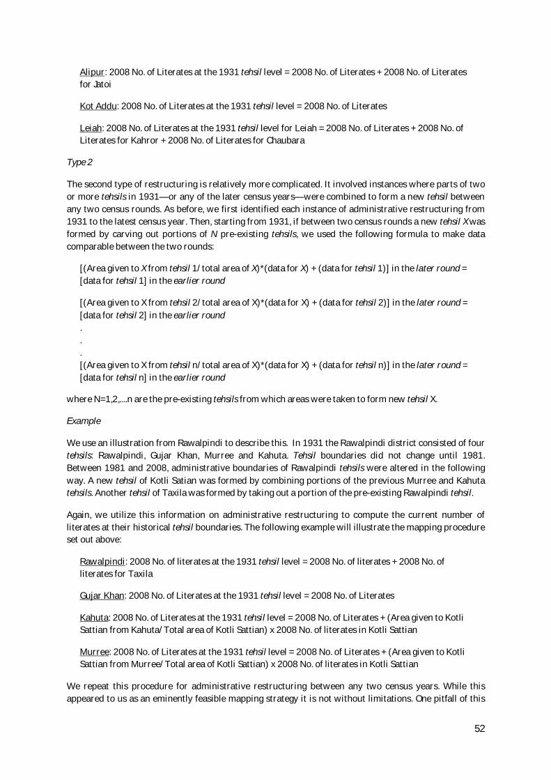
52
Alipur: 2008 No. of Literates at the 1931 tehsil level = 2008 No. of Literates + 2008 No. of Literates for Jatoi
Kot Addu: 2008 No. of Literates at the 1931 tehsil level = 2008 No. of Literates
Leiah: 2008 No. of Literates at the 1931 tehsil level for Leiah = 2008 No. of Literates + 2008 No. of Literates for Kahror + 2008 No. of Literates for Chaubara
Type 2
The second type of restructuring is relatively more complicated. It involved instances where parts of two or more tehsils in 1931—or any of the later census years—were combined to form a new tehsil between any two census rounds. As before, we first identified each instance of administrative restructuring from 1931 to the latest census year. Then, starting from 1931, if between two census rounds a new tehsil X was formed by carving out portions of N pre-existing tehsils, we used the following formula to make data comparable between the two rounds:
[(Area given to X from tehsil 1/total area of X)*(data for X) + (data for tehsil 1)] in the later round = [data for tehsil 1] in the earlier round
[(Area given to X from tehsil 2/total area of X)*(data for X) + (data for tehsil 2)] in the later round = [data for tehsil 2] in the earlier round . . . [(Area given to X from tehsil n/total area of X)*(data for X) + (data for tehsil n)] in the later round = [data for tehsil n] in the earlier round
where N=1,2,....n are the pre-existing tehsils from which areas were taken to form new tehsil X.
Example
We use an illustration from Rawalpindi to describe this. In 1931 the Rawalpindi district consisted of four tehsils: Rawalpindi, Gujar Khan, Murree and Kahuta. Tehsil boundaries did not change until 1981. Between 1981 and 2008, administrative boundaries of Rawalpindi tehsils were altered in the following way. A new tehsil of Kotli Satian was formed by combining portions of the previous Murree and Kahuta tehsils. Another tehsil of Taxila was formed by taking out a portion of the pre-existing Rawalpindi tehsil.
Again, we utilize this information on administrative restructuring to compute the current number of literates at their historical tehsil boundaries. The following example will illustrate the mapping procedure set out above:
Rawalpindi: 2008 No. of literates at the 1931 tehsil level = 2008 No. of literates + 2008 No. of literates for Taxila
Gujar Khan: 2008 No. of Literates at the 1931 tehsil level = 2008 No. of Literates
Kahuta: 2008 No. of Literates at the 1931 tehsil level = 2008 No. of Literates + (Area given to Kotli Sattian from Kahuta/Total area of Kotli Sattian) x 2008 No. of literates in Kotli Sattian
Murree: 2008 No. of Literates at the 1931 tehsil level = 2008 No. of Literates + (Area given to Kotli Sattian from Murree/Total area of Kotli Sattian) x 2008 No. of literates in Kotli Sattian
We repeat this procedure for administrative restructuring between any two census years. While this appeared to us as an eminently feasible mapping strategy it is not without limitations. One pitfall of this

53
mapping strategy is that it assumes a direct correspondence between the proportion of area and the proportion of literates. It assumes that development outcomes are uniformly distributed across different areas of a tehsil. If, for example, development outcomes are more unevenly distributed in urban areas then the bias induced by our mapping procedure will be stronger. Unfortunately, we don’t have data capturing such within tehsil variation. In the absence of other feasible means of aggregation, this is an imperfect but the best available option.

54
A P P E N D I X 3 : List of tehsils in the 118 country sample
District Tehsil District Tehsil Attock Attock Attock Fateh Jang Attock Hasanabdal Attock Hazro Attock Jand Attock Pindigheb Bahawalnagar Bahawalnagar Bahawalnagar Chishtian Bahawalnagar Fort Abbas Bahawalnagar Haroonabad Bahawalnagar Minchinabad Bahawalpur Ahmedpur East Bahawalpur Bahawalpur Bahawalpur Hasilpur Bahawalpur Khairpur Tamewali Bahawalpur Yazman Bhakkar Bhakkar Bhakkar Darya Khan Bhakkar Kallur Kot Bhakkar Mankera Chakwal Chakwal Chakwal Choa Saidan Shah Chakwal Talagang D.G. Khan DG Khan D.G. Khan Taunsa Faisalabad Chak Jhumra Town Faisalabad Faisalabad Faisalabad Jaranwala Town Faisalabad Sumundri Town Faisalabad Tandlianwala Town Gujranwala Gujranwala Gujranwala Kamoke Town Gujranwala Nowshera Virkan Town Gujranwala Wazirabad Town Gujrat Gujrat Gujrat Kharian Gujrat Sara-e-Alamgir Hafizabad Hafizabad Hafizabad Pindi Bhattian Jhang Ahmadpur Sial Jhang Chinniot Jhang Jhang Jhang Shorkot Jhelum Jhelum Jhelum Pind Dadan Khan Kasur Chunian Kasur Kasur Kasur Pattoki Khanewal Jahanian Khanewal Kabirwala Khanewal Khanewal Khanewal Mian Channu Khushab Khushab Khushab Noorpur Thal Lahore Lahore Layyah Choubara Layyah Karor Lal Esan Layyah Layyah Lodhran Dunya Pur
Lodhran Kehror Pacca Lodhran Lodhran Mandi Bahauddin Malakwal Mandi Bahauddin Mandi Bahauddin Mandi Bahauddin Phalia Mianwali Essa Khel Mianwali Mianwali Mianwali Piplan Multan Jalalpur Pirwala Town Multan Multan Multan Shujabad Town Muzaffargarh Ali pur Muzaffargarh Jatoi Muzaffargarh Kot Addu Muzaffargarh Muzaffargarh Nankana Sahib Nankana Sahib Nankana Sahib Sangla Hill Nankana Sahib Shah Kot Narowal Narowal Narowal Shakargarh Okara Depalpur Okara Okara Okara Renala Khurd Pakpattan Arifwala Pakpattan Pakpattan R.Y. Khan Khanpur R.Y. Khan Liaqatpur R.Y. Khan RY Khan R.Y. Khan Sadiqabad Rajanpur Jampur Rajanpur Rajanpur Rawalpindi Gujjar Khan Town Rawalpindi Kahuta Town Rawalpindi Murree Town Rawalpindi Rawalpindi Rawalpindi Taxila Town Sahiwal Chichawatni Sahiwal Sahiwal Sargodha Bhalwal Sargodha Kot Momin Sargodha Sahiwal2 Sargodha Sargodha Sargodha Shahpur Sargodha Sillanwali Sheikhupura Ferozewala Sheikhupura Muridke Sheikhupura Safdarabad Sheikhupura Sharaqpur Sharif Sheikhupura Sheikhupura Sialkot Daska Sialkot Pasrur Sialkot Sambrial Sialkot Sialkot TT Singh Gojra TT Singh Kamalia TT Singh TT Singh Vehari Burewala Vehari Mailsi Vehari Vehari

55
A P P E N D I X 4 : List of Punjab tehsils in the historical sample
Year District Tehsil 1931 Jhang Jhang 1931 Jhang Chinniot 1931 Jhang Shorkot 1931 Jhelum Jhelum 1931 Jhelum Pind Dadan Khan 1931 Jhelum Chakwal 1931 Attock Attock 1931 Attock Fateh Jang 1931 Attock Pindi Gheb 1931 Attock Talagang 1931 Bahawalpur Bahawalpur 1931 Bahawalpur Ahmedpur Sharqi 1931 Bahawalpur Ahmedpur Lamma 1931 Bahawalpur Allahabad 1931 Bahawalpur Bahawalnagar* 1931 Bahawalpur Khairpur 1931 Bahawalpur Khanpur 1931 Bahawalpur Minchinabad 1931 Dera Ghazi Khan Dera Ghazi Khan 1931 Dera Ghazi Khan Taunsa 1931 Dera Ghazi Khan Jampur 1931 Dera Ghazi Khan Rajanpur 1931 Lyallpur Lyallpur* 1931 Lyallpur Jaranwala* 1931 Lyallpur Sumundri* 1931 Lyallpur Toba Tek Singh* 1931 Gujranwala Gujranwala 1931 Gujranwala Wazirabad 1931 Gujranwala Hafizabad 1931 Gujrat Gujrat 1931 Gujrat Kharian 1931 Gujrat Phalia 1931 Mianwali Mianwali 1931 Mianwali Bhakkar 1931 Mianwali Essa Khel 1931 Montgomery Montgomery 1931 Montgomery Depalpur 1931 Montgomery Okara 1931 Montgomery Pak Pattan 1931 Multan Kabirwala 1931 Multan Khanewal 1931 Multan Multan 1931 Multan Lodhran 1931 Multan Shujabad 1931 Multan Mailsi 1931 Muzaffargarh Muzaffargarh 1931 Muzaffargarh Kot Addu 1931 Muzaffargarh Leiah* 1931 Muzaffargarh Ali Pur 1931 Mianwali Piplan 1931 Mianwali Essa Khel 1931 Lahore Lahore 1931 Lahore Kasur 1931 Lahore Chunian 1931 Rawalpindi Rawalpindi 1931 Rawalpindi Gujar Khan 1931 Rawalpindi Kahuta 1931 Rawalpindi Murree 1931 Shahpur Bhalwal 1931 Shahpur Khushab

56
1931 Shahpur Sargodha 1931 Shahpur Shahpur 1931 Sheikhupura Sheikhupura 1931 Sheikhupura Nankana Sahib 1931 Sheikhupura Shahdara 1931 Sialkot Narowal 1931 Sialkot Pasrur 1931 Sialkot Shakargarh* 1931 Sialkot Sialkot 1931 Sialkot Daska
Notes: * Tehsils included in sample for Table 9.
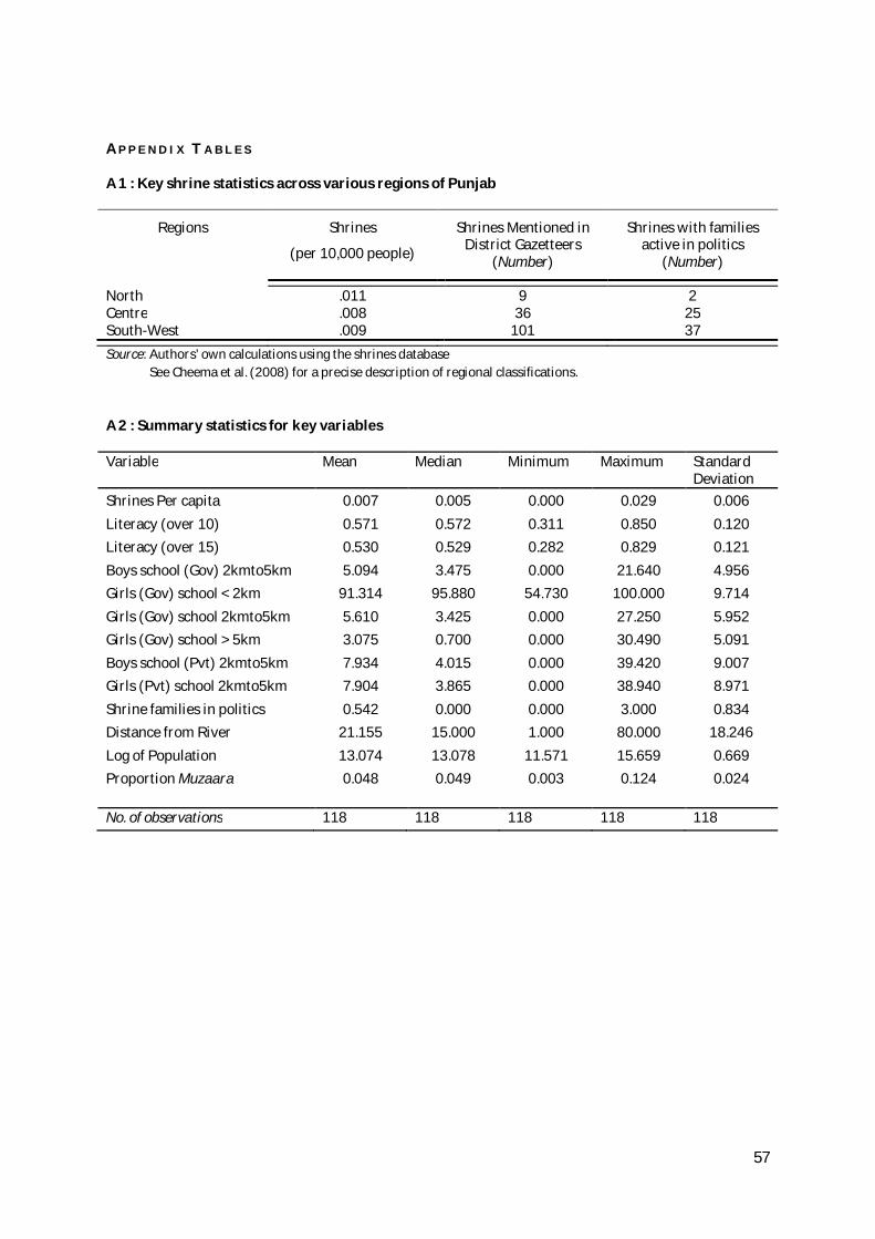
57
A P P E N D I X T A B L E S
A 1 : Key shrine statistics across various regions of Punjab
Regions Shrines
(per 10,000 people)
Shrines Mentioned in District Gazetteers
(Number)
Shrines with families active in politics
(Number)
North .011 9 2 Centre .008 36 25 South-West .009 101 37 Source: Authors’ own calculations using the shrines database See Cheema et al. (2008) for a precise description of regional classifications.
A 2 : Summary statistics for key variables
Variable Mean Median Minimum Maximum Standard Deviation
Shrines Per capita 0.007 0.005 0.000 0.029 0.006 Literacy (over 10) 0.571 0.572 0.311 0.850 0.120 Literacy (over 15) 0.530 0.529 0.282 0.829 0.121 Boys school (Gov) 2kmto5km 5.094 3.475 0.000 21.640 4.956 Girls (Gov) school < 2km 91.314 95.880 54.730 100.000 9.714 Girls (Gov) school 2kmto5km 5.610 3.425 0.000 27.250 5.952 Girls (Gov) school > 5km 3.075 0.700 0.000 30.490 5.091 Boys school (Pvt) 2kmto5km 7.934 4.015 0.000 39.420 9.007 Girls (Pvt) school 2kmto5km 7.904 3.865 0.000 38.940 8.971 Shrine families in politics 0.542 0.000 0.000 3.000 0.834 Distance from River 21.155 15.000 1.000 80.000 18.246 Log of Population 13.074 13.078 11.571 15.659 0.669 Proportion Muzaara 0.048 0.049 0.003 0.124 0.024 No. of observations 118 118 118 118 118

58
A D D I T I O N A L M A T E R I A L
T A B L E A 1 : Zaildars from Shrine Families, selected districts and years
Year District Tehsil Name of Zail Name of Zaildar & Tribe
1929 Muzaffargarh Alipur Shahr Sultan Diwan Muhammad Ghaus1929 Muzaffargarh Alipur Bande Shah S. Bande Shah1929 Muzaffargarh Alipur Sitpur Khan Sahib Makhdum Muhammad Hassan1929 Muzaffargarh Alipur Dhaka S. Turab Ali Shah1929 Muzaffargarh Leiah Marhanwali S. Amir Ahmad Shah1929 Muzaffargarh Leiah Karor S. Ghulam Sarwar Shah1929 Muzaffargarh Leiah Bet Dabli S. Jind Wadda Shah1914 Mianwali Mianwali Daud Khel Sayyid Qaim Hussain Shah1914 Mianwali Bhakkar Panjgirain Ghulam Kasim Shah1917 Shahpur Khushab Pail Pir Chan Pir of Pail1917 Shahpur Khushab Sodhi Jaiwali Chan Pir of Sodhi Jaiwali1917 Shahpur Shahpur Shahpur Sayyad Najaf Shah of Shahpur1917 Shahpur Shahpur Thatti Shahani Feroz Din Shah of Thatti Shahani1917 Shahpur Shahpur Jahanianshah Pir Sultan Ali Shah of Jahanianshah1917 Shahpur Bhera Bhera Ali Haidar Shah of Alipur1929 Jhang Jhang ... Mohammad Shah (Shah Jewana)1929 Jhang Jhang Kot Isa Shah Allahyar Shah (Shah Jewana)1929 Jhang Jhang ... Mohammad Ghaus; Bahadar Shah (Rajoa Sayids)1929 Jhang Chiniot Kot Khudayar Saleh Shah
Source: Punjab District Gazetteers (various issues).
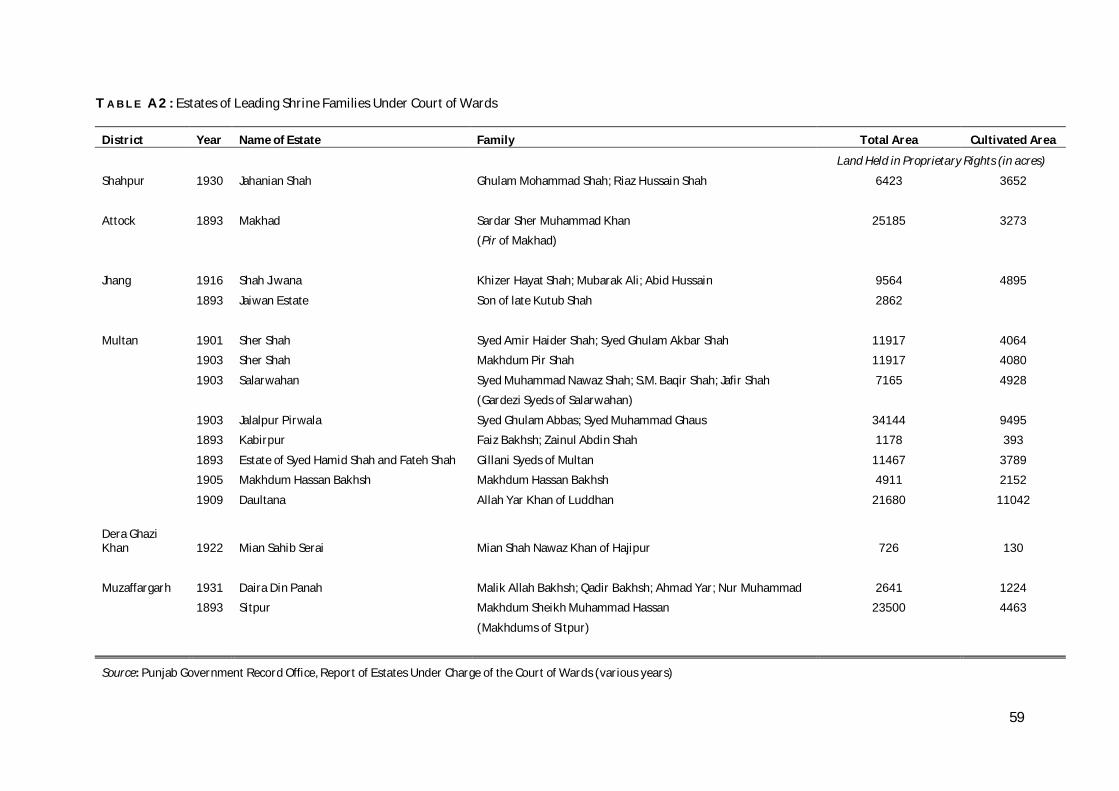
59
T A B L E A 2 : Estates of Leading Shrine Families Under Court of Wards
District Year Name of Estate Family Total Area Cultivated Area
Land Held in Proprietary Rights (in acres)
Shahpur 1930 Jahanian Shah Ghulam Mohammad Shah; Riaz Hussain Shah 6423 3652
Attock 1893 Makhad Sardar Sher Muhammad Khan 25185 3273
(Pir of Makhad)
Jhang 1916 Shah Jiwana Khizer Hayat Shah; Mubarak Ali; Abid Hussain 9564 4895
1893 Jaiwan Estate Son of late Kutub Shah 2862
Multan 1901 Sher Shah Syed Amir Haider Shah; Syed Ghulam Akbar Shah 11917 4064
1903 Sher Shah Makhdum Pir Shah 11917 4080
1903 Salarwahan Syed Muhammad Nawaz Shah; S.M. Baqir Shah; Jafir Shah 7165 4928
(Gardezi Syeds of Salarwahan)
1903 Jalalpur Pirwala Syed Ghulam Abbas; Syed Muhammad Ghaus 34144 9495
1893 Kabirpur Faiz Bakhsh; Zainul Abdin Shah 1178 393
1893 Estate of Syed Hamid Shah and Fateh Shah Gillani Syeds of Multan 11467 3789
1905 Makhdum Hassan Bakhsh Makhdum Hassan Bakhsh 4911 2152
1909 Daultana Allah Yar Khan of Luddhan 21680 11042
Dera Ghazi Khan 1922 Mian Sahib Serai Mian Shah Nawaz Khan of Hajipur 726 130
Muzaffargarh 1931 Daira Din Panah Malik Allah Bakhsh; Qadir Bakhsh; Ahmad Yar; Nur Muhammad 2641 1224
1893 Sitpur Makhdum Sheikh Muhammad Hassan 23500 4463
(Makhdums of Sitpur)
Source: Punjab Government Record Office, Report of Estates Under Charge of the Court of Wards (various years)