Embed Size (px)
Citation preview
RELEASE GUIDE WEBGIS
August 29, 2018
August 29, 2018 2
Contents
About This Release .................................................................................................................. 4
GeoMedia WebMap .............................................................................................................. 4
Geospatial Portal .................................................................................................................. 4
Geospatial SDI ..................................................................................................................... 4
New Platforms .......................................................................................................................... 4
Licensing .............................................................................................................................. 4
New Technology ....................................................................................................................... 5
Geospatial Portal .................................................................................................................. 5
Vector data for Consumer Layout ................................................................................... 5
Efficient vector data display ............................................................................................ 5
Feature Information displayed in Consumer Layout ........................................................ 6
Take measurements in Consumer Layout ....................................................................... 6
Quick map printing in Consumer Layout ......................................................................... 7
Automatic classification, color assignment in Thematic legend in Geospatial Portal ....... 7
Go to my location in Consumer Portal ............................................................................. 9
Simplified query panel in Geospatial Portal ..................................................................... 9
Scale bands for restricting the data display ................................................................... 10
Maximum zoom level for Consumer Portal released ..................................................... 11
GeoMedia WebMap ............................................................................................................ 11
Simplified publishing workflows for GeoMedia WebMap ............................................... 11
Remote service publishing ............................................................................................ 13
Automated LRF file creation .......................................................................................... 13
WFS metadata settings in Administration Console ....................................................... 13
System Requirements ........................................................................................................... 14
GeoMedia WebMap ............................................................................................................ 14
August 29, 2018 3
Geospatial Portal ................................................................................................................ 16
Geospatial SDI ................................................................................................................... 17
Issues Resolved ..................................................................................................................... 19
Geospatial Server 2018 ...................................................................................................... 19
GeoMedia WebMap, Geospatial Portal, Geospatial SDI ............................................... 19
About Us ................................................................................................................................. 33
Copyright ................................................................................................................................ 34
About This Release
August 29, 2018 4
ABOUT THIS RELEASE This document describes the enhancements for WebGIS products, including GeoMedia WebMap, Geospatial Portal, and Geospatial SDI. Although the information in this document is current as of the product release, see the Hexagon Geospatial Support website for the most current version.
This release includes both enhancements and fixes. For information on enhancements, see the New Technology section. For information on fixes that were made to the WebGIS products for this release, see the Issues Resolved section.
This document is only an overview and does not provide all of the details about the product's capabilities. See the online help and other documents provided with the WebGIS products for more information.
GEOMEDIA WEBMAP GeoMedia WebMap supports a broad range of customers who need to visualize and examine geographic data on the Web. From easily creating standards-compliant web services to providing sophisticated visualization and analysis within interactive web mapping applications, GeoMedia WebMap enables building powerful solutions for sharing your organization’s rich geospatial data.
GEOSPATIAL PORTAL Geospatial Portal is a fully featured, configurable, and customizable thin client application that can be used for finding, viewing, querying, analyzing, and consuming geospatial data published by Hexagon Geospatial products and/or other standards-based web services. The portal can be accessed by multiple users via web browsers as it is installed and configured on a web application server.
GEOSPATIAL SDI Geospatial SDI is an interoperable and scalable component of spatial data infrastructure for cataloging and delivering enterprise geospatial data over the web. It is designed for data providers that need to manage and serve secure or licensed information using standards-based web services. It offers powerful tools for controlled access to standards-compliant services and data published by those services, as well as tools for monitoring and reporting service performance. The product adheres to Open Geospatial Consortium (OGC®), INSPIRE, and International Standards Organization (ISO) standards for web services and metadata compliance. Geospatial SDI can easily extend solutions based on GeoMedia® WebMap, ERDAS® APOLLO, or any other vendor’s OGC-compliant product to assure the full set of services required for implementation of custom secure Spatial Data Infrastructure (SDI).
NEW PLATFORMS
LICENSING Starting with the Power Portfolio 2018 release, licenses are no longer based on Certificate-file based technology. Instead, licenses are based on Activation IDs, allowing you to activate products without providing Host IDs or other hardware-related parameters. You can also re-host without emailing the licensing team for assistance. The Power Portfolio 2018 release also includes improved tools that make it easier to install licenses, set up license servers, and provide more professional error handling. Finally, the Power Portfolio 2018 release includes improved customer notification in the products, such as an “end of subscription”
New Technology
August 29, 2018 5
message in the Start-up screen. These more secure and automated processes, along with a new licensing portal, provide you with a better overall user experience.
NEW TECHNOLOGY
GEOSPATIAL PORTAL
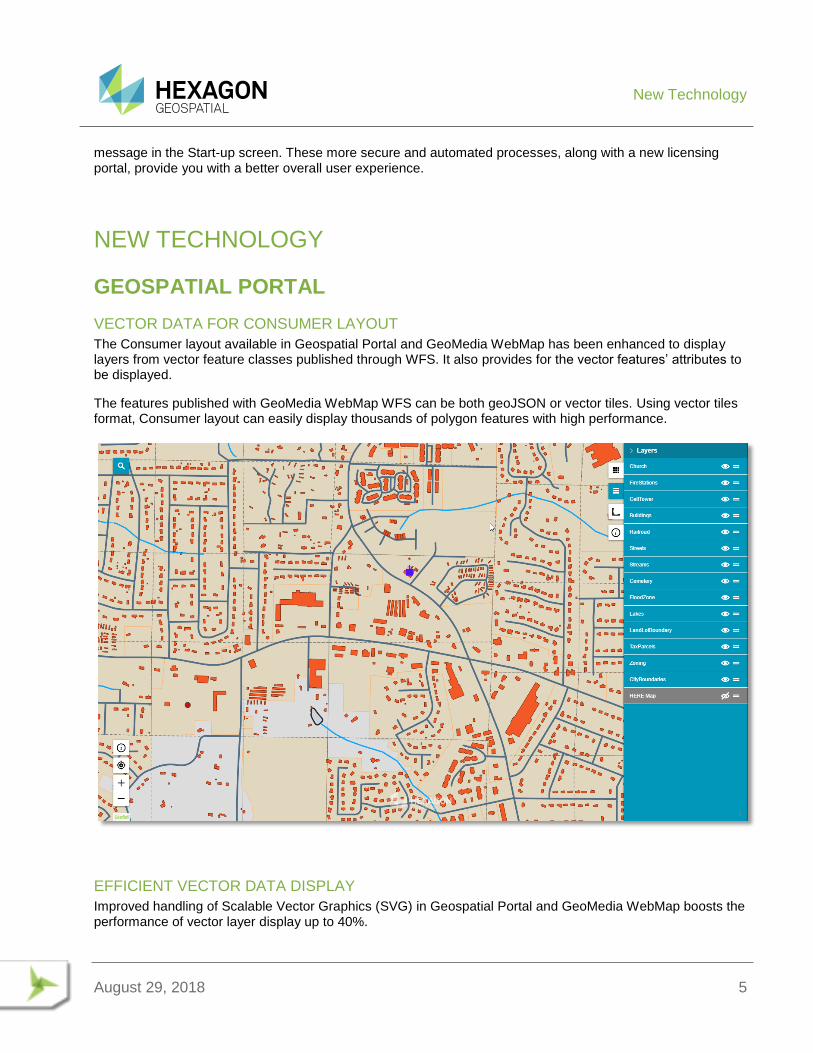
VECTOR DATA FOR CONSUMER LAYOUT
The Consumer layout available in Geospatial Portal and GeoMedia WebMap has been enhanced to display layers from vector feature classes published through WFS. It also provides for the vector features’ attributes to be displayed.
The features published with GeoMedia WebMap WFS can be both geoJSON or vector tiles. Using vector tiles format, Consumer layout can easily display thousands of polygon features with high performance.
EFFICIENT VECTOR DATA DISPLAY
Improved handling of Scalable Vector Graphics (SVG) in Geospatial Portal and GeoMedia WebMap boosts the performance of vector layer display up to 40%.
New Technology
August 29, 2018 6
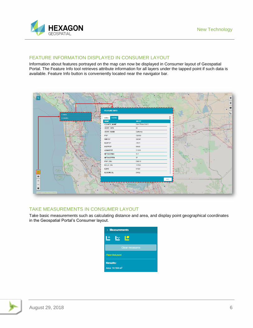
FEATURE INFORMATION DISPLAYED IN CONSUMER LAYOUT
Information about features portrayed on the map can now be displayed in Consumer layout of Geospatial Portal. The Feature Info tool retrieves attribute information for all layers under the tapped point if such data is available. Feature Info button is conveniently located near the navigator bar.
TAKE MEASUREMENTS IN CONSUMER LAYOUT
Take basic measurements such as calculating distance and area, and display point geographical coordinates in the Geospatial Portal’s Consumer layout.
New Technology
August 29, 2018 7
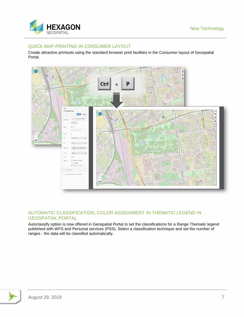
QUICK MAP PRINTING IN CONSUMER LAYOUT
Create attractive printouts using the standard browser print facilities in the Consumer layout of Geospatial Portal.
AUTOMATIC CLASSIFICATION, COLOR ASSIGNMENT IN THEMATIC LEGEND IN GEOSPATIAL PORTAL
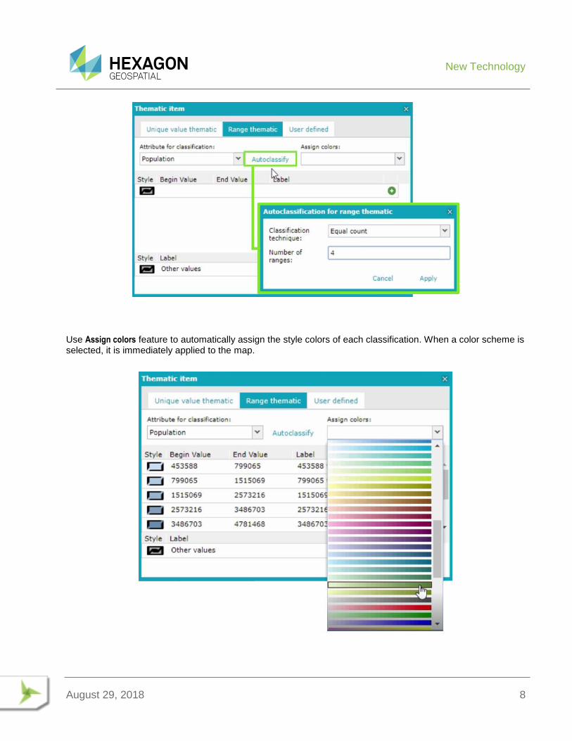
Autoclassify option is now offered in Geospatial Portal to set the classifications for a Range Thematic legend published with WFS and Personal services (PSS). Select a classification technique and set the number of ranges - the data will be classified automatically.
New Technology
August 29, 2018 8
Use Assign colors feature to automatically assign the style colors of each classification. When a color scheme is selected, it is immediately applied to the map.
New Technology
August 29, 2018 9
GO TO MY LOCATION IN CONSUMER PORTAL
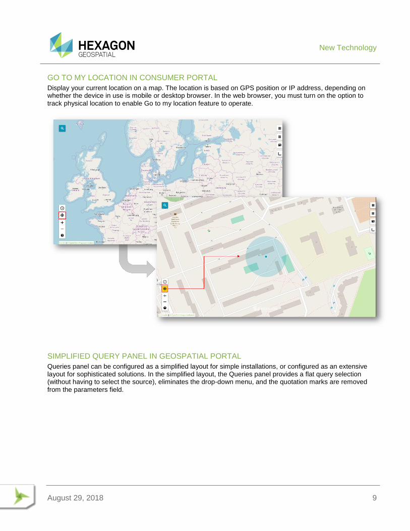
Display your current location on a map. The location is based on GPS position or IP address, depending on whether the device in use is mobile or desktop browser. In the web browser, you must turn on the option to track physical location to enable Go to my location feature to operate.
SIMPLIFIED QUERY PANEL IN GEOSPATIAL PORTAL
Queries panel can be configured as a simplified layout for simple installations, or configured as an extensive layout for sophisticated solutions. In the simplified layout, the Queries panel provides a flat query selection (without having to select the source), eliminates the drop-down menu, and the quotation marks are removed from the parameters field.
New Technology
August 29, 2018 10
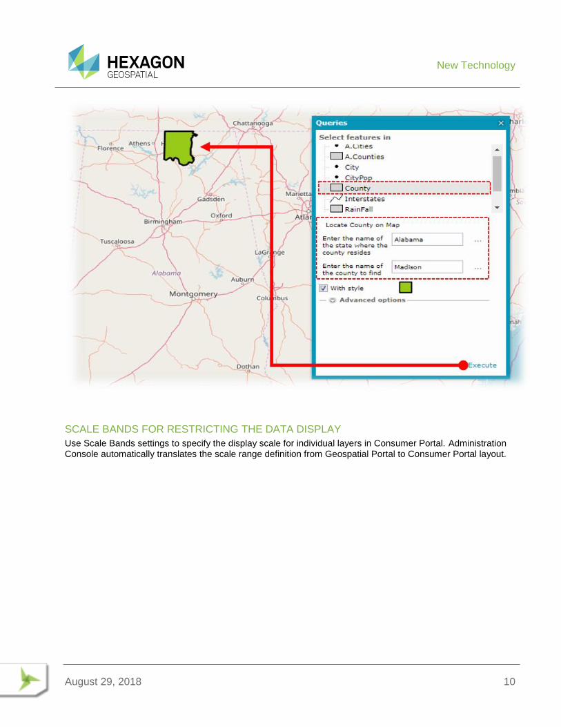
SCALE BANDS FOR RESTRICTING THE DATA DISPLAY
Use Scale Bands settings to specify the display scale for individual layers in Consumer Portal. Administration Console automatically translates the scale range definition from Geospatial Portal to Consumer Portal layout.
New Technology
August 29, 2018 11
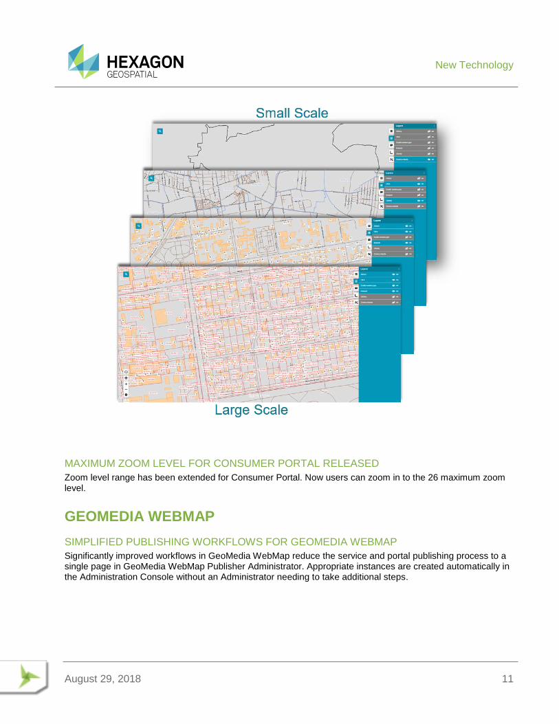
MAXIMUM ZOOM LEVEL FOR CONSUMER PORTAL RELEASED
Zoom level range has been extended for Consumer Portal. Now users can zoom in to the 26 maximum zoom level.
GEOMEDIA WEBMAP
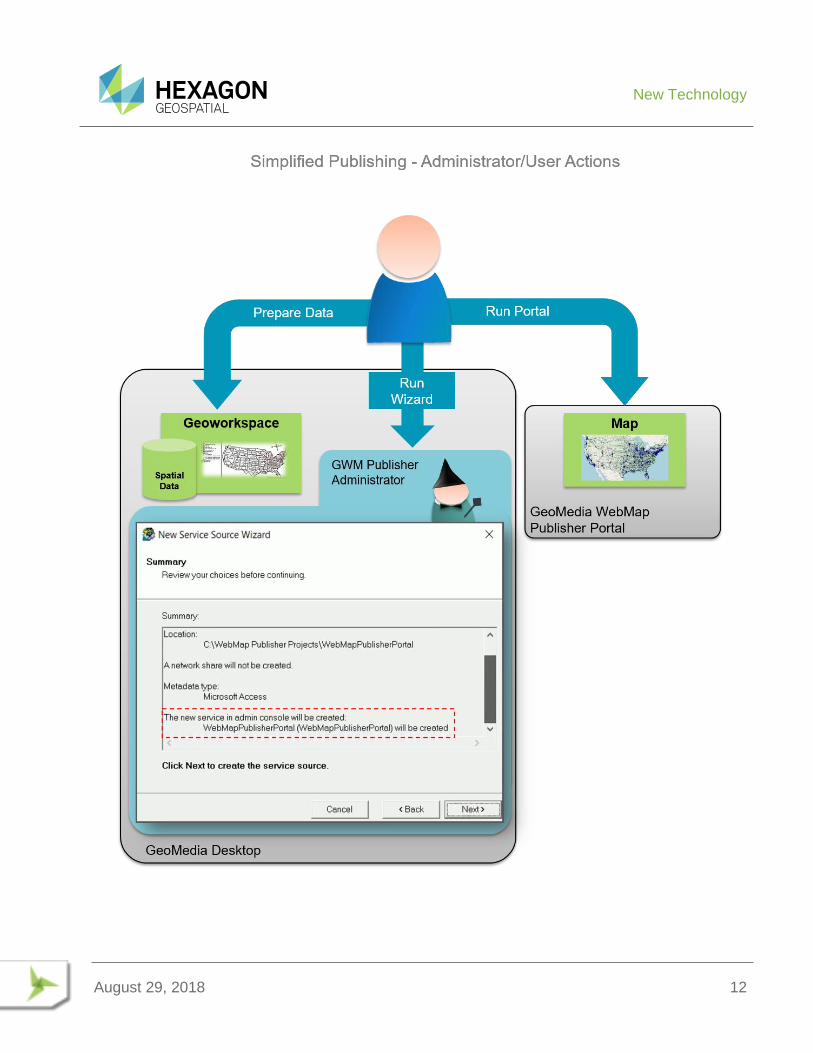
SIMPLIFIED PUBLISHING WORKFLOWS FOR GEOMEDIA WEBMAP
Significantly improved workflows in GeoMedia WebMap reduce the service and portal publishing process to a single page in GeoMedia WebMap Publisher Administrator. Appropriate instances are created automatically in the Administration Console without an Administrator needing to take additional steps.
New Technology
August 29, 2018 12
New Technology
August 29, 2018 13
REMOTE SERVICE PUBLISHING
Using new GeoMedia WebMap Publisher capabilities, an Administrator can easily create fully operational services (WMS and WFS), as well as create WebMap Publisher Portals on remote server machines. The enhanced wizard performs all the necessary actions: creating the Service Source, creating the Service (or Portal) Instance, and binding them together. All that remains is to publish the data.
AUTOMATED LRF FILE CREATION
Administrators no longer need to manually create LRF files. When publishing GeoMedia GeoWorkspace with dynamic labelling configuration, a corresponding LRF file is generated automatically.
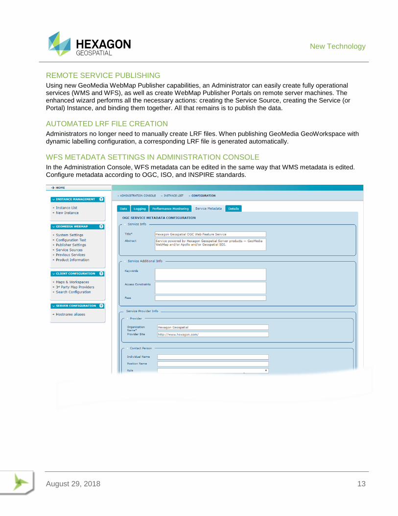
WFS METADATA SETTINGS IN ADMINISTRATION CONSOLE
In the Administration Console, WFS metadata can be edited in the same way that WMS metadata is edited. Configure metadata according to OGC, ISO, and INSPIRE standards.
System Requirements
August 29, 2018 14
SYSTEM REQUIREMENTS
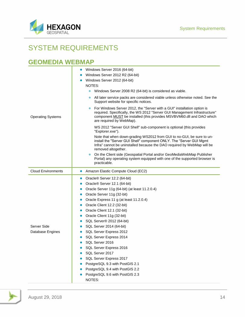
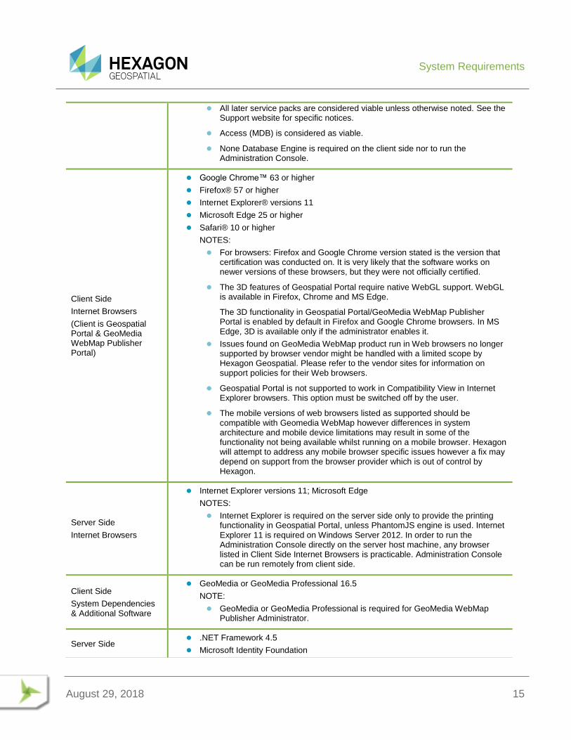
GEOMEDIA WEBMAP
Operating Systems
Windows Server 2016 (64-bit)
Windows Server 2012 R2 (64-bit)
Windows Server 2012 (64-bit)
NOTES:
Windows Server 2008 R2 (64-bit) is considered as viable.
All later service packs are considered viable unless otherwise noted. See the Support website for specific notices.
For Windows Server 2012, the "Server with a GUI" installation option is required. Specifically, the WS 2012 "Server GUI Management Infrastructure" component MUST be installed (this provides MSVBVM60.dll and DAO which are required by WebMap).
WS 2012 "Server GUI Shell" sub-component is optional (this provides "Explorer.exe").
Note that when down-grading WS2012 from GUI to no-GUI, be sure to un-install the "Server GUI Shell" component ONLY. The “Server GUI Mgmt Infra" cannot be uninstalled because the DAO required by WebMap will be removed altogether.
On the Client side (Geospatial Portal and/or GeoMediaWebMap Publisher Portal) any operating system equipped with one of the supported browser is practicable.
Cloud Environments Amazon Elastic Compute Cloud (EC2)
Server Side
Database Engines
Oracle® Server 12.2 (64-bit)
Oracle® Server 12.1 (64-bit)
Oracle Server 11g (64-bit) (at least 11.2.0.4)
Oracle Server 11g (32-bit)
Oracle Express 11 g (at least 11.2.0.4)
Oracle Client 12.2 (32-bit)
Oracle Client 12.1 (32-bit)
Oracle Client 11g (32-bit)
SQL Server® 2012 (64-bit)
SQL Server 2014 (64-bit)
SQL Server Express 2012
SQL Server Express 2014
SQL Server 2016
SQL Server Express 2016
SQL Server 2017
SQL Server Express 2017
PostgreSQL 9.3 with PostGIS 2.1
PostgreSQL 9.4 with PostGIS 2.2
PostgreSQL 9.6 with PostGIS 2.3
NOTES:
System Requirements
August 29, 2018 15
All later service packs are considered viable unless otherwise noted. See the Support website for specific notices.
Access (MDB) is considered as viable.
None Database Engine is required on the client side nor to run the Administration Console.
Client Side
Internet Browsers
(Client is Geospatial Portal & GeoMedia WebMap Publisher Portal)
Google Chrome™ 63 or higher
Firefox® 57 or higher
Internet Explorer® versions 11
Microsoft Edge 25 or higher
Safari® 10 or higher
NOTES:
For browsers: Firefox and Google Chrome version stated is the version that certification was conducted on. It is very likely that the software works on newer versions of these browsers, but they were not officially certified.
The 3D features of Geospatial Portal require native WebGL support. WebGL is available in Firefox, Chrome and MS Edge.
The 3D functionality in Geospatial Portal/GeoMedia WebMap Publisher Portal is enabled by default in Firefox and Google Chrome browsers. In MS Edge, 3D is available only if the administrator enables it.
Issues found on GeoMedia WebMap product run in Web browsers no longer supported by browser vendor might be handled with a limited scope by Hexagon Geospatial. Please refer to the vendor sites for information on support policies for their Web browsers.
Geospatial Portal is not supported to work in Compatibility View in Internet Explorer browsers. This option must be switched off by the user.
The mobile versions of web browsers listed as supported should be compatible with Geomedia WebMap however differences in system architecture and mobile device limitations may result in some of the functionality not being available whilst running on a mobile browser. Hexagon will attempt to address any mobile browser specific issues however a fix may depend on support from the browser provider which is out of control by Hexagon.
Server Side
Internet Browsers
Internet Explorer versions 11; Microsoft Edge
NOTES:
Internet Explorer is required on the server side only to provide the printing functionality in Geospatial Portal, unless PhantomJS engine is used. Internet Explorer 11 is required on Windows Server 2012. In order to run the Administration Console directly on the server host machine, any browser listed in Client Side Internet Browsers is practicable. Administration Console can be run remotely from client side.
Client Side
System Dependencies & Additional Software
GeoMedia or GeoMedia Professional 16.5
NOTE:
GeoMedia or GeoMedia Professional is required for GeoMedia WebMap Publisher Administrator.
Server Side .NET Framework 4.5
Microsoft Identity Foundation
System Requirements
August 29, 2018 16
System Dependencies & Additional Software
Windows Installer 3.1 or higher
Internet Information Services (IIS) 7.x or 8.0
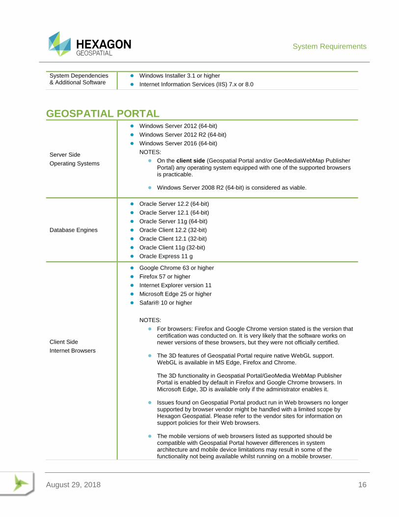
GEOSPATIAL PORTAL
Server Side
Operating Systems
Windows Server 2012 (64-bit)
Windows Server 2012 R2 (64-bit)
Windows Server 2016 (64-bit)
NOTES:
On the client side (Geospatial Portal and/or GeoMediaWebMap Publisher
Portal) any operating system equipped with one of the supported browsers is practicable.
Windows Server 2008 R2 (64-bit) is considered as viable.
Database Engines
Oracle Server 12.2 (64-bit)
Oracle Server 12.1 (64-bit)
Oracle Server 11g (64-bit)
Oracle Client 12.2 (32-bit)
Oracle Client 12.1 (32-bit)
Oracle Client 11g (32-bit)
Oracle Express 11 g
Client Side
Internet Browsers
Google Chrome 63 or higher
Firefox 57 or higher
Internet Explorer version 11
Microsoft Edge 25 or higher
Safari® 10 or higher
NOTES:
For browsers: Firefox and Google Chrome version stated is the version that certification was conducted on. It is very likely that the software works on newer versions of these browsers, but they were not officially certified.
The 3D features of Geospatial Portal require native WebGL support. WebGL is available in MS Edge, Firefox and Chrome.
The 3D functionality in Geospatial Portal/GeoMedia WebMap Publisher Portal is enabled by default in Firefox and Google Chrome browsers. In Microsoft Edge, 3D is available only if the administrator enables it.
Issues found on Geospatial Portal product run in Web browsers no longer supported by browser vendor might be handled with a limited scope by Hexagon Geospatial. Please refer to the vendor sites for information on support policies for their Web browsers.
The mobile versions of web browsers listed as supported should be compatible with Geospatial Portal however differences in system architecture and mobile device limitations may result in some of the functionality not being available whilst running on a mobile browser.
System Requirements
August 29, 2018 17
Hexagon will attempt to address any mobile browser specific issues however a fix may depend on support from the browser provider which is out of control by Hexagon.
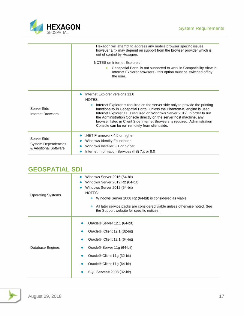
NOTES on Internet Explorer:
Geospatial Portal is not supported to work in Compatibility View in Internet Explorer browsers - this option must be switched off by the user.
Server Side
Internet Browsers
Internet Explorer versions 11.0
NOTES:
Internet Explorer is required on the server side only to provide the printing functionality in Geospatial Portal, unless the PhantomJS engine is used. Internet Explorer 11 is required on Windows Server 2012. In order to run the Administration Console directly on the server host machine, any browser listed in Client Side Internet Browsers is required. Administration Console can be run remotely from client side.
Server Side
System Dependencies & Additional Software
.NET Framework 4.5 or higher
Windows Identity Foundation
Windows Installer 3.1 or higher
Internet Information Services (IIS) 7.x or 8.0
GEOSPATIAL SDI
Operating Systems
Windows Server 2016 (64-bit)
Windows Server 2012 R2 (64-bit)
Windows Server 2012 (64-bit)
NOTES:
Windows Server 2008 R2 (64-bit) is considered as viable.
All later service packs are considered viable unless otherwise noted. See the Support website for specific notices.
Database Engines
Oracle® Server 12.1 (64-bit)
Oracle® Client 12.1 (32-bit)
Oracle® Client 12.1 (64-bit)
Oracle® Server 11g (64-bit)
Oracle® Client 11g (32-bit)
Oracle® Client 11g (64-bit)
SQL Server® 2008 (32-bit)
System Requirements
August 29, 2018 18
SQL Server® 2008 (64-bit)
SQL Server® 2008 R2 (32-bit)
SQL Server® 2008 R2 (64-bit)
SQL Server® 2012
SQL Server® 2014
Access® 2010 (MDAC2010 v14)
NOTES:
All later service packs are considered viable unless otherwise noted. See the Support website for specific notices.
NHibernate, Log4Net and ADO.NET are used for accessing database in SDI Pro Security and Logging mechanisms. The full list of supported database engines depends on these third party frameworks. However, SDI services were used successfully with listed engines.
64-bit Oracle Data Access Components (ODAC) is required for Catalogue (CSW) services running with Oracle Server 12 (64-bit)
Internet Browsers
(required to run Administration Console)
Google Chrome 63 or higher
Firefox 57 or higher
Internet Explorer versions 11
Microsoft Edge 25 or higher
NOTES:
For browsers: Firefox, Google Chrome version stated is the version that certification was conducted on. It is very likely that the software works on newer versions of these browsers, but they were not officially certified.
Issues found on Geospatial SDI product run in Web browsers no longer supported by browser vendor might be handled with a limited scope by Hexagon Geospatial. Please refer to the vendor sites for information on support policies for their Web browsers.
Server Side
System Dependencies & Additional Software
.NET Framework 4.5
Windows Identity Foundation
Windows Installer 3.1 or higher
Internet Information Services (IIS) 7.x or 8.0
NOTES:
All later service packs for the system dependencies are considered supported unless otherwise noted. See the support website for specific notices.
Issues Resolved
August 29, 2018 19
ISSUES RESOLVED
GEOSPATIAL SERVER 2018
GEOMEDIA WEBMAP, GEOSPATIAL PORTAL, GEOSPATIAL SDI
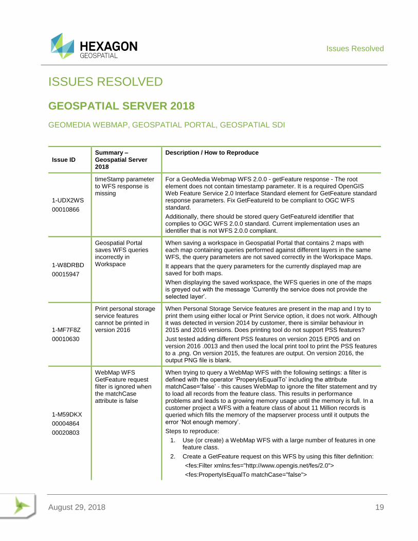
Issue ID Summary – Geospatial Server 2018
Description / How to Reproduce
1-UDX2WS
00010866
timeStamp parameter to WFS response is missing
For a GeoMedia Webmap WFS 2.0.0 - getFeature response - The root element does not contain timestamp parameter. It is a required OpenGIS Web Feature Service 2.0 Interface Standard element for GetFeature standard response parameters. Fix GetFeatureId to be compliant to OGC WFS standard.
Additionally, there should be stored query GetFeatureId identifier that complies to OGC WFS 2.0.0 standard. Current implementation uses an identifier that is not WFS 2.0.0 compliant.
1-W8DRBD
00015947
Geospatial Portal saves WFS queries incorrectly in Workspace
When saving a workspace in Geospatial Portal that contains 2 maps with each map containing queries performed against different layers in the same WFS, the query parameters are not saved correctly in the Workspace Maps.
It appears that the query parameters for the currently displayed map are saved for both maps.
When displaying the saved workspace, the WFS queries in one of the maps is greyed out with the message ‘Currently the service does not provide the selected layer’.
1-MF7F8Z
00010630
Print personal storage service features cannot be printed in version 2016
When Personal Storage Service features are present in the map and I try to print them using either local or Print Service option, it does not work. Although it was detected in version 2014 by customer, there is similar behaviour in 2015 and 2016 versions. Does printing tool do not support PSS features?
Just tested adding different PSS features on version 2015 EP05 and on version 2016 .0013 and then used the local print tool to print the PSS features to a .png. On version 2015, the features are output. On version 2016, the output PNG file is blank.
1-M59DKX
00004864
00020803
WebMap WFS GetFeature request filter is ignored when the matchCase attribute is false
When trying to query a WebMap WFS with the following settings: a filter is defined with the operator ‘ProperyIsEqualTo’ including the attribute matchCase=’false’ - this causes WebMap to ignore the filter statement and try to load all records from the feature class. This results in performance problems and leads to a growing memory usage until the memory is full. In a customer project a WFS with a feature class of about 11 Million records is queried which fills the memory of the mapserver process until it outputs the error ‘Not enough memory’.
Steps to reproduce:
1. Use (or create) a WebMap WFS with a large number of features in one feature class.
2. Create a GetFeature request on this WFS by using this filter definition:
<fes:Filter xmlns:fes="http://www.opengis.net/fes/2.0">
<fes:PropertyIsEqualTo matchCase="false">
Issues Resolved
August 29, 2018 20
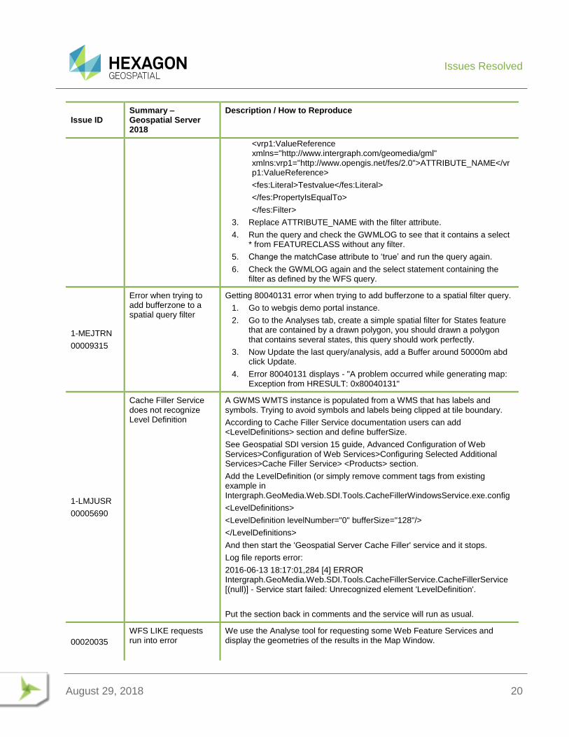
Issue ID Summary – Geospatial Server 2018
Description / How to Reproduce
<vrp1:ValueReference xmlns="http://www.intergraph.com/geomedia/gml" xmlns:vrp1="http://www.opengis.net/fes/2.0">ATTRIBUTE_NAME</vrp1:ValueReference>
<fes:Literal>Testvalue</fes:Literal>
</fes:PropertyIsEqualTo>
</fes:Filter>
3. Replace ATTRIBUTE_NAME with the filter attribute.
4. Run the query and check the GWMLOG to see that it contains a select * from FEATURECLASS without any filter.
5. Change the matchCase attribute to ‘true’ and run the query again.
6. Check the GWMLOG again and the select statement containing the filter as defined by the WFS query.
1-MEJTRN
00009315
Error when trying to add bufferzone to a spatial query filter
Getting 80040131 error when trying to add bufferzone to a spatial filter query.
1. Go to webgis demo portal instance.
2. Go to the Analyses tab, create a simple spatial filter for States feature that are contained by a drawn polygon, you should drawn a polygon that contains several states, this query should work perfectly.
3. Now Update the last query/analysis, add a Buffer around 50000m abd click Update.
4. Error 80040131 displays - "A problem occurred while generating map: Exception from HRESULT: 0x80040131"
1-LMJUSR
00005690
Cache Filler Service does not recognize Level Definition
A GWMS WMTS instance is populated from a WMS that has labels and symbols. Trying to avoid symbols and labels being clipped at tile boundary.
According to Cache Filler Service documentation users can add <LevelDefinitions> section and define bufferSize.
See Geospatial SDI version 15 guide, Advanced Configuration of Web Services>Configuration of Web Services>Configuring Selected Additional Services>Cache Filler Service> <Products> section.
Add the LevelDefinition (or simply remove comment tags from existing example in Intergraph.GeoMedia.Web.SDI.Tools.CacheFillerWindowsService.exe.config
<LevelDefinitions>
<LevelDefinition levelNumber="0" bufferSize="128"/>
</LevelDefinitions>
And then start the 'Geospatial Server Cache Filler' service and it stops.
Log file reports error:
2016-06-13 18:17:01,284 [4] ERROR Intergraph.GeoMedia.Web.SDI.Tools.CacheFillerService.CacheFillerService [(null)] - Service start failed: Unrecognized element 'LevelDefinition'.
Put the section back in comments and the service will run as usual.
00020035
WFS LIKE requests run into error
We use the Analyse tool for requesting some Web Feature Services and display the geometries of the results in the Map Window.
Issues Resolved
August 29, 2018 21
Issue ID Summary – Geospatial Server 2018
Description / How to Reproduce
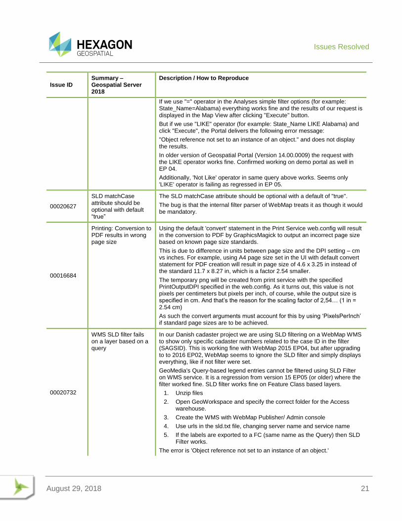
If we use "=" operator in the Analyses simple filter options (for example: State_Name=Alabama) everything works fine and the results of our request is displayed in the Map View after clicking "Execute" button.
But if we use "LIKE" operator (for example: State_Name LIKE Alabama) and click "Execute", the Portal delivers the following error message:
"Object reference not set to an instance of an object." and does not display the results.
In older version of Geospatial Portal (Version 14.00.0009) the request with the LIKE operator works fine. Confirmed working on demo portal as well in EP 04.
Additionally, 'Not Like' operator in same query above works. Seems only 'LIKE' operator is failing as regressed in EP 05.
00020627
SLD matchCase attribute should be optional with default “true”
The SLD matchCase attribute should be optional with a default of "true".
The bug is that the internal filter parser of WebMap treats it as though it would be mandatory.
00016684
Printing: Conversion to PDF results in wrong page size
Using the default 'convert' statement in the Print Service web.config will result in the conversion to PDF by GraphicsMagick to output an incorrect page size based on known page size standards.
This is due to difference in units between page size and the DPI setting – cm vs inches. For example, using A4 page size set in the UI with default convert statement for PDF creation will result in page size of 4.6 x 3.25 in instead of the standard 11.7 x 8.27 in, which is a factor 2.54 smaller.
The temporary png will be created from print service with the specified PrintOutputDPI specified in the web.config. As it turns out, this value is not pixels per centimeters but pixels per inch, of course, while the output size is specified in cm. And that’s the reason for the scaling factor of 2,54… (1 in = 2.54 cm)
As such the convert arguments must account for this by using ‘PixelsPerInch’ if standard page sizes are to be achieved.
00020732
WMS SLD filter fails on a layer based on a query
In our Danish cadaster project we are using SLD filtering on a WebMap WMS to show only specific cadaster numbers related to the case ID in the filter (SAGSID). This is working fine with WebMap 2015 EP04, but after upgrading to to 2016 EP02, WebMap seems to ignore the SLD filter and simply displays everything, like if not filter were set.
GeoMedia's Query-based legend entries cannot be filtered using SLD Filter on WMS service. It is a regression from version 15 EP05 (or older) where the filter worked fine. SLD filter works fine on Feature Class based layers.
1. Unzip files
2. Open GeoWorkspace and specify the correct folder for the Access warehouse.
3. Create the WMS with WebMap Publisher/ Admin console
4. Use urls in the sld.txt file, changing server name and service name
5. If the labels are exported to a FC (same name as the Query) then SLD Filter works.
The error is 'Object reference not set to an instance of an object.'
Issues Resolved
August 29, 2018 22
Issue ID Summary – Geospatial Server 2018
Description / How to Reproduce
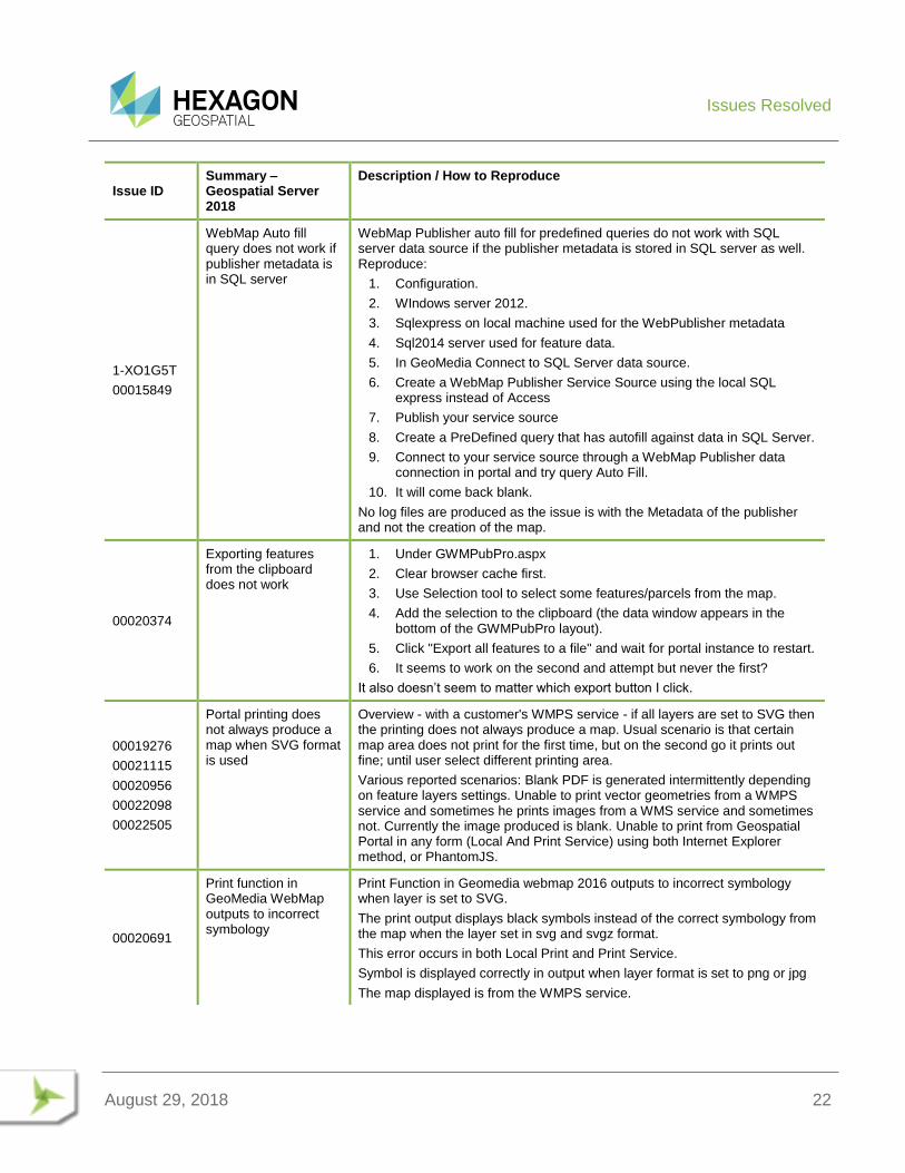
1-XO1G5T
00015849
WebMap Auto fill query does not work if publisher metadata is in SQL server
WebMap Publisher auto fill for predefined queries do not work with SQL server data source if the publisher metadata is stored in SQL server as well. Reproduce:
1. Configuration.
2. WIndows server 2012.
3. Sqlexpress on local machine used for the WebPublisher metadata
4. Sql2014 server used for feature data.
5. In GeoMedia Connect to SQL Server data source.
6. Create a WebMap Publisher Service Source using the local SQL express instead of Access
7. Publish your service source
8. Create a PreDefined query that has autofill against data in SQL Server.
9. Connect to your service source through a WebMap Publisher data connection in portal and try query Auto Fill.
10. It will come back blank.
No log files are produced as the issue is with the Metadata of the publisher and not the creation of the map.
00020374
Exporting features from the clipboard does not work
1. Under GWMPubPro.aspx
2. Clear browser cache first.
3. Use Selection tool to select some features/parcels from the map.
4. Add the selection to the clipboard (the data window appears in the bottom of the GWMPubPro layout).
5. Click "Export all features to a file" and wait for portal instance to restart.
6. It seems to work on the second and attempt but never the first?
It also doesn’t seem to matter which export button I click.
00019276
00021115
00020956
00022098
00022505
Portal printing does not always produce a map when SVG format is used
Overview - with a customer's WMPS service - if all layers are set to SVG then the printing does not always produce a map. Usual scenario is that certain map area does not print for the first time, but on the second go it prints out fine; until user select different printing area.
Various reported scenarios: Blank PDF is generated intermittently depending on feature layers settings. Unable to print vector geometries from a WMPS service and sometimes he prints images from a WMS service and sometimes not. Currently the image produced is blank. Unable to print from Geospatial Portal in any form (Local And Print Service) using both Internet Explorer method, or PhantomJS.
00020691
Print function in GeoMedia WebMap outputs to incorrect symbology
Print Function in Geomedia webmap 2016 outputs to incorrect symbology when layer is set to SVG.
The print output displays black symbols instead of the correct symbology from the map when the layer set in svg and svgz format.
This error occurs in both Local Print and Print Service.
Symbol is displayed correctly in output when layer format is set to png or jpg
The map displayed is from the WMPS service.
Issues Resolved
August 29, 2018 23
Issue ID Summary – Geospatial Server 2018
Description / How to Reproduce
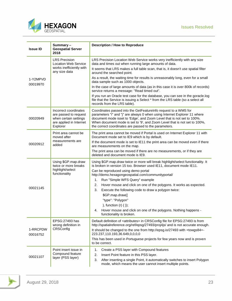
1-Y2MPVD
00019970
LRS Precision Location Web Service works inefficiently with any size data
LRS Precision Location Web Service works very inefficiently with any size data and times out when running large amounts of data.
It seems that LRS makes a full table scan, that is, it doesn't use spatial filter around the searched point.
As a result, the waiting time for results is unreasonably long, even for a small data sample such as 1000 objects.
In the case of large amounts of data (as in this case it is over 800k of records) service returns a message: "Read timed out".
If you run an Oracle test case for the database, you can see in the goracle.log file that the Service is issuing a Select * from the LRS table (so a select all records from the LRS table).
00020949
Incorrect coordinates are passed to request when certain settings are applied in Internet Explorer
Coordinates passed into the GetFeatureInfo request to a WMS for parameters "i" and "j" are always 0 when using Internet Explorer 11 where document mode isset to 'Edge', and Zoom Level that is not set to 100%. When document mode is set to '9', and Zoom Level that is not set to 100%, the correct coordinates are passed to the parameters.
00020912
Print area cannot be moved after measurements are added
The print area cannot be moved if Portal is used on Internet Explorer 11 with Document mode set to IE9 which is by default.
If the document mode is set to IE11 the print area can be moved even if there are measurements on the map.
The print area can be moved if there are no measurements, or if they are deleted and document mode is IE9.
00021145
Using $GP.map.draw twice or more breaks highlight/select functionality
Using $GP.map.draw twice or more will break highlight/select functionality. It is broken in version 15 too. Browser used IE11, document mode IE11.
Can be reproduced using demo portal http://demo.hexagongeospatial.com/communityportal/
1. Run "Simple WFS Query" example
2. Hover mouse and click on one of the polygons. It works as expected.
3. Execute the following code to draw a polygon twice:
$GP.map.draw({
"type": "Polygon"
}, function (r) { });
4. Hover mouse and click on one of the polygons. Nothing happens - functionality is broken.
1-RRCPDW
00016752
EPSG:27493 has wrong definition in CRSConfig
Default definition of <attributes> in CRSConfig file for EPSG:27493 is from http://spatialreference.org/ref/epsg/27493/proj4js/ and is not accurate enough.
It should be changed to the one from http://epsg.io/27493 with +towgs84=-223.237,110.193,36.649,0,0,0,0
This has been used in Portuguese projects for few years now and is proven to be correct.
00021107
Point insert issue in Compound feature layer (PSS layer)
1. Create a PSS layer with Compound features
2. Insert Point feature in this PSS layer.
3. After inserting a single Point, it automatically switches to insert Polygon mode, which means the user cannot insert multiple points.
Issues Resolved
August 29, 2018 24
Issue ID Summary – Geospatial Server 2018
Description / How to Reproduce
4. User has to manually click "Insert Point" to continue inserting another point.
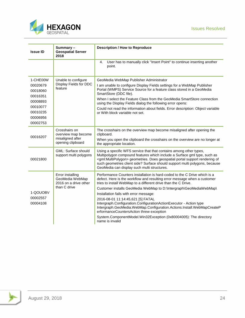
1-CHE00W
00020679
00018060
00016351
00008893
00010077
00010235
00006956
00002753
Unable to configure Display Fields for DDC feature
GeoMedia WebMap Publisher Administrator
I am unable to configure Display Fields settings for a WebMap Publisher Portal (WMPS) Service Source for a feature class stored in a GeoMedia SmartStore (DDC file).
When I select the Feature Class from the GeoMedia SmartStore connection using the Display Fields dialog the following error opens:
Could not read the information about fields. Error description: Object variable or With block variable not set.
00016207
Crosshairs on overview map become misaligned after opening clipboard
The crosshairs on the overview map become misaligned after opening the clipboard.
When you open the clipboard the crosshairs on the overview are no longer at the appropriate location.
00021800
GML: Surface should support multi polygons
Using a specific WFS service that that contains among other types, Multipolygon compound features which include a Surface gml type, such as <gml:MultiPolygon> geometries. Does geospatial portal support rendering of such geometries client side? Surface should support multi polygons, because GeoMedia can display such multi structures.
1-QOUOBV
00002557
00004108
Error installing GeoMedia WebMap 2016 on a drive other than C drive
Performance Counters installation is hard-coded to the C Drive which is a defect. Here is the workflow and resulting error message when a customer tries to install WebMap to a different drive than the C Drive.
Customer installs GeoMedia WebMap to D:\Intergraph\GeoMediaWebMap\
Installation fails with error message:
2016-08-01 11:14:45,621 [5] FATAL Intergraph.Configuration.ConfigurationActionExecutor - Action type Intergraph.GeoMedia.WebMap.Configuration.Actions.Install.WebMapCreatePerformanceCountersAction threw exception
System.ComponentModel.Win32Exception (0x80004005): The directory name is invalid
Issues Resolved
August 29, 2018 25
Issue ID Summary – Geospatial Server 2018
Description / How to Reproduce
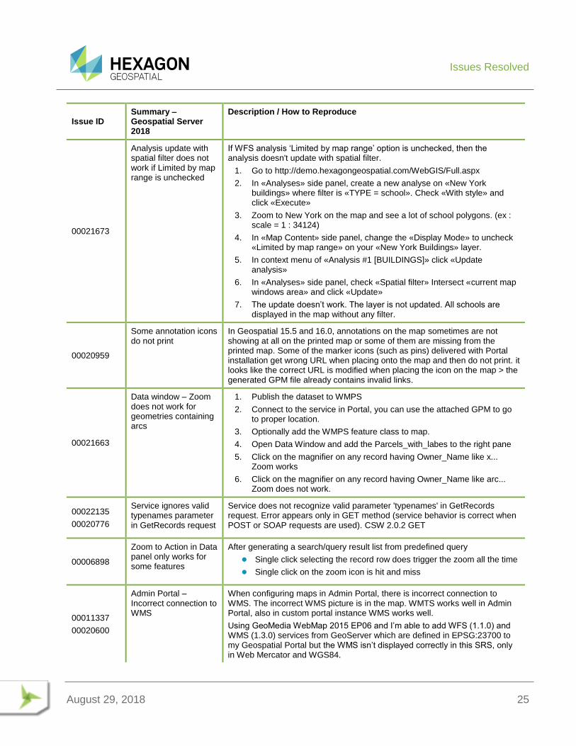
00021673
Analysis update with spatial filter does not work if Limited by map range is unchecked
If WFS analysis ‘Limited by map range’ option is unchecked, then the analysis doesn't update with spatial filter.
1. Go to http://demo.hexagongeospatial.com/WebGIS/Full.aspx
2. In «Analyses» side panel, create a new analyse on «New York buildings» where filter is «TYPE = school». Check «With style» and click «Execute»
3. Zoom to New York on the map and see a lot of school polygons. (ex : scale = 1 : 34124)
4. In «Map Content» side panel, change the «Display Mode» to uncheck «Limited by map range» on your «New York Buildings» layer.
5. In context menu of «Analysis #1 [BUILDINGS]» click «Update analysis»
6. In «Analyses» side panel, check «Spatial filter» Intersect «current map windows area» and click «Update»
7. The update doesn’t work. The layer is not updated. All schools are displayed in the map without any filter.
00020959
Some annotation icons do not print
In Geospatial 15.5 and 16.0, annotations on the map sometimes are not showing at all on the printed map or some of them are missing from the printed map. Some of the marker icons (such as pins) delivered with Portal installation get wrong URL when placing onto the map and then do not print. it looks like the correct URL is modified when placing the icon on the map > the generated GPM file already contains invalid links.
00021663
Data window – Zoom does not work for geometries containing arcs
1. Publish the dataset to WMPS
2. Connect to the service in Portal, you can use the attached GPM to go to proper location.
3. Optionally add the WMPS feature class to map.
4. Open Data Window and add the Parcels_with_labes to the right pane
5. Click on the magnifier on any record having Owner_Name like x... Zoom works
6. Click on the magnifier on any record having Owner_Name like arc... Zoom does not work.
00022135
00020776
Service ignores valid typenames parameter in GetRecords request
Service does not recognize valid parameter 'typenames' in GetRecords request. Error appears only in GET method (service behavior is correct when POST or SOAP requests are used). CSW 2.0.2 GET
00006898
Zoom to Action in Data panel only works for some features
After generating a search/query result list from predefined query
Single click selecting the record row does trigger the zoom all the time
Single click on the zoom icon is hit and miss
00011337
00020600
Admin Portal – Incorrect connection to WMS
When configuring maps in Admin Portal, there is incorrect connection to WMS. The incorrect WMS picture is in the map. WMTS works well in Admin Portal, also in custom portal instance WMS works well.
Using GeoMedia WebMap 2015 EP06 and I’m able to add WFS (1.1.0) and WMS (1.3.0) services from GeoServer which are defined in EPSG:23700 to my Geospatial Portal but the WMS isn’t displayed correctly in this SRS, only in Web Mercator and WGS84.
Issues Resolved
August 29, 2018 26
Issue ID Summary – Geospatial Server 2018
Description / How to Reproduce
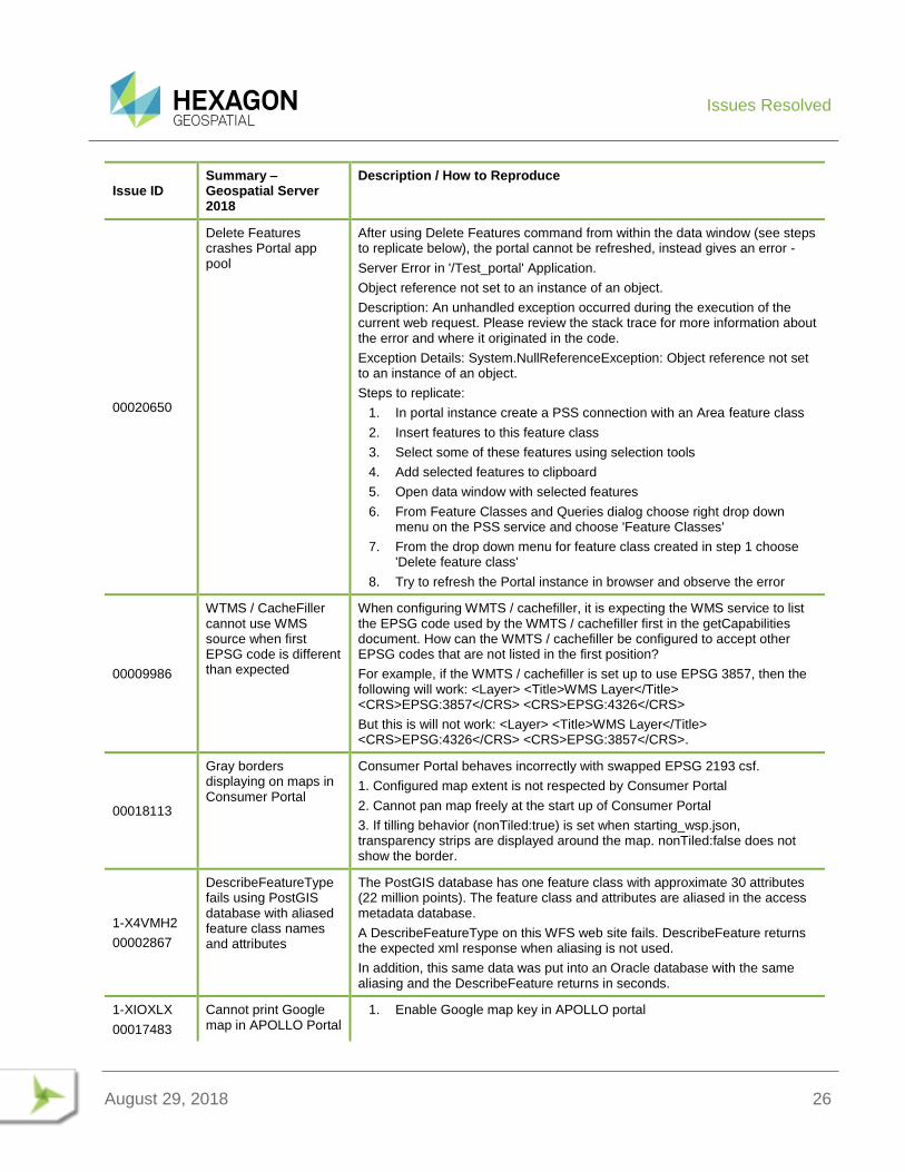
00020650
Delete Features crashes Portal app pool
After using Delete Features command from within the data window (see steps to replicate below), the portal cannot be refreshed, instead gives an error -
Server Error in '/Test_portal' Application.
Object reference not set to an instance of an object.
Description: An unhandled exception occurred during the execution of the current web request. Please review the stack trace for more information about the error and where it originated in the code.
Exception Details: System.NullReferenceException: Object reference not set to an instance of an object.
Steps to replicate:
1. In portal instance create a PSS connection with an Area feature class
2. Insert features to this feature class
3. Select some of these features using selection tools
4. Add selected features to clipboard
5. Open data window with selected features
6. From Feature Classes and Queries dialog choose right drop down menu on the PSS service and choose 'Feature Classes'
7. From the drop down menu for feature class created in step 1 choose 'Delete feature class'
8. Try to refresh the Portal instance in browser and observe the error
00009986
WTMS / CacheFiller cannot use WMS source when first EPSG code is different than expected
When configuring WMTS / cachefiller, it is expecting the WMS service to list the EPSG code used by the WMTS / cachefiller first in the getCapabilities document. How can the WMTS / cachefiller be configured to accept other EPSG codes that are not listed in the first position?
For example, if the WMTS / cachefiller is set up to use EPSG 3857, then the following will work: <Layer> <Title>WMS Layer</Title> <CRS>EPSG:3857</CRS> <CRS>EPSG:4326</CRS>
But this is will not work: <Layer> <Title>WMS Layer</Title> <CRS>EPSG:4326</CRS> <CRS>EPSG:3857</CRS>.
00018113
Gray borders displaying on maps in Consumer Portal
Consumer Portal behaves incorrectly with swapped EPSG 2193 csf.
1. Configured map extent is not respected by Consumer Portal
2. Cannot pan map freely at the start up of Consumer Portal
3. If tilling behavior (nonTiled:true) is set when starting_wsp.json, transparency strips are displayed around the map. nonTiled:false does not show the border.
1-X4VMH2
00002867
DescribeFeatureType fails using PostGIS database with aliased feature class names and attributes
The PostGIS database has one feature class with approximate 30 attributes (22 million points). The feature class and attributes are aliased in the access metadata database.
A DescribeFeatureType on this WFS web site fails. DescribeFeature returns the expected xml response when aliasing is not used.
In addition, this same data was put into an Oracle database with the same aliasing and the DescribeFeature returns in seconds.
1-XIOXLX
00017483
Cannot print Google map in APOLLO Portal
1. Enable Google map key in APOLLO portal
Issues Resolved
August 29, 2018 27
Issue ID Summary – Geospatial Server 2018
Description / How to Reproduce
00022098
00022461
00022505
2. From portal > Data source: Add Google map service and print service (http://<APOLLOSERVER>/PrintService/PortalPrintService.svc)
3. Print catalog image with Google map as basemap
[What was expected to happen] - Both the cataloged image and Google map should be rendered in the final print (e.g., PNG)
[What did happen] - Only the catalog image is rendered.
NOTE: No such issue with OpenStreetMap.
1-YURRPU
00019650
ExportToGeoJsonService does not prefix primary keys
WebMap
The ExportToGeoJsonService does not prefix the PrimaryKeys with the table name compared to the ExportToGmlService. This means that if I have a recordset collection as input, the PKs can have collisions.
1-T4A8FJ
Text info from WMTS visualized in Consumer Portal is illegible
The Consumer Portal instance does not appear to be using the correct scale when working with WMTS services.
As a result there are several consequences:
Multiple requests to the WMTS service.
Mobile browser hangs due to the great number of images and requests
Information visualized in the Consumer is illegible and thus useless, since it is not possible to “read” the map (street names, locations etc.).
1-DWB32H
00017854
00013885
Consumer Portal does not display transparent tiles from WMTS
Consumer Portal does not display transparent tiles from WMTS (png)
I have created a Consumer Portal instance.
I have added one WMTS in map, but tiles are not transparent.
Is there any way to make tiles transparent?
We would like to have Consumer Portal setup to use an WMTS instead of an WMS. - Our WMS source for some reason is particularly slow at present, WMTS very fast (investigating WMS performance separately) - Using WMTS means Consumer Portal can zoom into the full extents of the aerial photography instead of the extents defined by OpenStreetMap. We observe when using WMS source, the minimum zoom seems to be defined by the tile 'steps' from OpenStreetMap or WMTS, even if the WMS can zoom in further - WMTS tends to give the perception of faster draw.
When we switch to WMTS, the format JPEG is always used even if the WMTS supports PNG. There is no way to specify that PNG should be used for consumer portal. Note: Reason we want to use PNG instead of JPEG is get correct transparency. JPEG shows a big white box where the aerials are transparent meaning underlying layers cannot be observed and the white box looks bad against other background data.
00021528
FeatureInfo command should not make the object become selected
When using the Feature Info command against WMPS objects, they become selected in the map (when displayed in SVG format). They should not become selected.
This behaviour does not happen when using the Feature Info command against Personal or WFS features.
00008461
00021918
WebMap WMS GetFeatureInfo is not rendering valid HTML content
When making a GetFeatureInfo request from OpenLayers to GeoMedia WebMap using the default HTML response, it causes a violation within OpenLayers code when using Internet Explorer. Though in Chrome and Firefox it is fine.
Issues Resolved
August 29, 2018 28
Issue ID Summary – Geospatial Server 2018
Description / How to Reproduce
1-7HXKUC
00004897
00005356
Leftover toolbar frame when toolbar closed from docked position
When closing the GMWM Publisher toolbar on GM2013, there is a leftover toolbar frame left open when the toolbar is docked. Workflow is - register Publisher with GeoMedia Pro, run Publisher, close Publisher using big red cross, then notice the remaining toolbar.
1-8VBUVS
00018924
Cannot see recently added CRS on the dropdown list
In Geospatial Portal settings, after adding either of these coordinate systems to the SRS list, it cannot be selected on the dropdown list. The display never changes to it. Geographic – North America – NAD27 (EPSG:4267), or EPSG:4269.
1-JEC8M2
00003015
Feature info from Analyses query result of WMPS incorrect
1. Created a WMPS, a Data Source for the WMPS with the Demo Data, and then connected to a Portal.
2. I do a query to select some States
3. Click GetInformation
4. Click on the map in a point where there is not any State of my query but there is a State and I get information from this state.
That could be OK but the problem is that if I have 7 queries of States to display different result I will get 7 results when I click on a point although there was only ONE state.
1-S3SJUK
00018175
MapSvr terminates immediately when memory threshold is exceeded
On version 2015 EP05, the MapSvr terminates immediately when the MapSvr Memory Threshold is exceeded.
In previous versions, the MapSvr was not restarted if the MapSvr's memory increased beyond the threshold while serving a request.
1-SM7ZUD
Include EPSG 2326 in the CRS lists that are hard-coded to use Easting/Northing coordinate order
Currently for a GWM WMS (or WFS) set in EPSG:2326 wanting to use a coordinate order of Easting/Northing (as it should) it is required to alter the GWM WMS web.config. The current product design is such that if an EPSG falls outside the range 4000-5000 (or 2180) and is not configured to use the CRSStore, the WMS will fall back to the default GWM behavior of using northing/easting coordinate order. As 2326 does not fall into the 4000-5000 range, it is to be treated as a “conventional” axis order CRS with the order being easting northing unless configured to use the CRSStore.
This manual configuration should not be expected of end customers who work mainly in this EPSG.
1-TPP9PH Option to rename warehouse connection optional
When publishing, WebMap Publisher changes the warehouse connection name, which is okay for those who do not manage their own names. But Administrators want renaming to be optional rather than mandatory.
SR-4436
Request GeoMedia be OGC WFS 2.0 compliant – application/gml+xml output format
Please add "outputFormat=application/gml+xml; version=3.2" into WFS service to become or work towards OGC WFS 2.0 compliance.
1-M0G1GG
Request for authorizationPipe to support outputFormat=application/gml+xml; version=3.2
Customer uses the requestModifier custom pipe to rewrite application/gml+xml; version=3.2 outputformat to text/xml. It works well except situation when authorizationPipe is in chain of pipes (after request Modifier pipe). Request for authorizationPipe to support outputFormat=application/gml+xml; version=3.2"
Issues Resolved
August 29, 2018 29
Issue ID Summary – Geospatial Server 2018
Description / How to Reproduce
1-XO6VW8
Security vulnerabilities found in Geospatial Portal
In preparation for creating a WebMap/Portal instance for external parties and a public WMS and WFS, we engaged a third party to perform penetration tests. The results revealed some critical vulnerabilities that need to be addressed, not only for our new instances, but also the existing instances we share with other companies (e.g. Ventia).
1-XJF56N
Request for WebMap WFS-T service to support PostGIS R/W dataserver
Customer created a WFS-T service published from PostGIS Dataserver. Then once the customer tried to do WFS-T type transactions, it did not work. I explained to the customer that to the best of my knowledge, WebMap only supports the Oracle R/W and Sql Server R/W databases for WFS-T services.
Therefore, this customer requested that PostGIS R/W dataserver/database be added as a supported database for WFS-T services.
1-Y7170B
00005107
Images in IMG format cannot be published to WMS or WMPS in WebMap v16 EP01 or 02
Client has published some images in IMG format using GeoMedia WebMap v15 EP05 (Some of them as WMS and some as WMPS). Now they have upgraded to v16. After upgrading to v16, the images are not visible in the portal. We have tested the same in v16 EP 01& EP 02. We tried to republish the images as WMS and as WMPS, but it’s not working.
00020428
Migrate Bing Maps API in Portal to v8
After Bing Maps migration from v7 to v8, there are few problems:
Logo and copyrights are under others components.
Microsoft.Map Dom has changed, so the variables: maps, _logo, _copyrights are null.
v8 doesn't have isDownloadingTiles() function, and targetviewchanged, tiledownloadcomplete events, so rendering never stops.
00018113
WebMap v15 EP05 Consumer Portal display issue
Consumer Portal behaves incorrectly with swapped 2193 csf.
Configured map extent is not respected by Consumer Portal
Cannot pan map freely at the start up of Consumer Portal
When tiling behavior is turned off while starting_wsp.json, transparency strips are displayed around the map.
SR-4750
Configure display of Data Window buttons – Remove All / Selected Features
Out-of-the-box there are two commands shown for WFS-T features displayed in the Data Window. Remove All Features and Remove Selected Features from Database. These commands are potentially dangerous if used maliciously or accidentally by a user and cannot be hidden through the configuration settings of a Geospatial Portal instance in Administration Console.
The ability to perform a mass deletion of data is an Administrative task and not a function that should be available to users.
This request is for Geospatial Portal to be enhanced to toggle the display of these buttons either via a web.config parameter or the layout configuration in the Administration Console.
00021232
WFS feature name with special character is not displaying
Customer has been using a WFS service for some years with special characters like the "é". Geospatial Portal 2015 works very well with this type of character. In the same example created in Geospatial Portal demo 2016, the character is not visible.
00017391 Consumer Portal does not display layer from
I'm trying to add a starting workspace for my Consumer Portal instance which contains services running on CRS EPSG:5514. But I always get error: Workspace cannot be set as a starting workspace in this application as it
Issues Resolved
August 29, 2018 30
Issue ID Summary – Geospatial Server 2018
Description / How to Reproduce
service working in EPSG:5514
contains map <WMS Map Name> which is displayed in non-supported CRS: EPSG:5514.
00021941
Local print does not work with Portal browse in HTTPS on LOB env
Our client has Geospatial Portal EP02, they configure portal instances to run under HTTPS. We add the print service for the portal. We found out that the local print does not work and it shows an error message -- {"error":"Unknown error"}
00022195
User administrator vs Administrator – case sensitivity
Portal behaves inconsistently when it comes to user names case-sensitivity:
If you login as "Administrator", the saved Workspaces/Maps are public
If you login as "administrator" the saved WS/Maps are not public
00022361
00022076
Portal does not work properly with ASP.NET Session State service
Portal can’t consume those services when the Session State in IIS is switched from InProc to State server. While trying to add the below mentioned services, Portal's backend responds with error 'Unable to serialize the session state.'
Services having the problem (what was tested so far):
APOLLO / APOLLO Essentials
LUWS
external PrintService
WCTS
WFS / WFS-G / GeoRSS
WMTS
WPS-CT
Feature Info does not work for WMPS / PSS
To reproduce:
1) Create default Portal instance - make sure PrintService connects fine
2) Go to IIS > Default Web Site > PortalInstance > Session State > select "State server", keeping things default
3) Start ASP.NET State service
4) Restart Portal. Notice that OSM layer won't display (SR-1467)
5) Try to connect to Print Service - you will receive an exception
00022262
Printing with printservice in XPS format does not print styles for WFS layers
1. Create a workspace and add one or more WFS layers.
2. Set styles for those WFS layers.
3. Print using a print service in PNG format.
4. In the legend, the WFS layers are listed together with their styles as 'icons'.
5. Do the same with XPS format.
6. WFS layers are listed but with no style.
00022457
Pan or Drag map event does not release properly if Geospatial Portal window has been resized
In GS Portal in a resized window, when you drag/pan the map, and let the mouse exit the window, the drag event leaves the map and goes to GS portal entire div and drags that instead.
This results in toolbars etc. getting lost behind the browser toolbars or in worse cases, when used embedded in an iFrame, behind that.
Issues Resolved
August 29, 2018 31
Issue ID Summary – Geospatial Server 2018
Description / How to Reproduce
When you resize the GS Portal window and then do a browser refresh, before panning/dragging the map, then this behaviour does not occur and GS Portal window / map acts as expected.
00020774 Proxy should not be required to download SVG map
Since the WMPS image maps are downloaded directly from the Cache folder, why do we need to use a proxy to download the SVG or SVGZ map?
1-7TIMI1
00013211
Clicking Register and choose layers button does not allow layers to be chosen
When you select a new service WMS or WMTS, you have to click buttons “Register and choose layers” and “Register and Display”.
In Full.aspx, when you click the button “Register and choose layers” after registry the service a new form is opened to select the layers, but when the start page is MapWithToolBar.aspx the form is not open. The same is happening with the page mapwithRibbon.aspx
1-7TVX3X
00018822
Expand image legend does not occur above a certain size
When you open the portal with mapwithtoolbar.aspx or mapwithriboon.aspx, the legend for an image is not expanded for WMS neither WMTS when the image is bigger than 20x1 pixels.
00022683
Measurements are incorrect when using EPSG:3436 projection
Using a GeoMedia project with EPSG 3436 - State Plane NAD 83 in feet for Illinois west. I have measurement set to "imperial" in web.config of my SDK application. Passing those easting / northing values to ConvertDDToDMS yields long/lat values are also correct.
All would be fine but distance measurement and area measurement (using the default tool buttons with the SDK) yields distances that are too big by a factor of 3.28084. They display with "mi" after them. The value would be correct if divided by 3.28084.
In the GeoMedia project where the WMPS data source is being created from, readout of long/lat, easting/northing, distance, area are all correct. The projection of the project is epsg 3436.
00022758
Applying attribute filter to analysis results of WFS layer removes the original spatial/attribute filter from the results
Applying attribute filter to analysis results of WFS layer removes the original spatial/attribute filter from the results.
1. Create a WFS service with demo data
2. Launch Geospatial Portal and connect to the WFS demo service
3. Create an Analysis for Counties with POP>750000
4. Apply a Filter (AVGTEMP>65) on the Counties analysis result and note the result showing ONLY AVGTEMP>65
SR-5123
Text placement issue in Windows 10 tab
Create a new PSS data source.
Insert a new Text feature in 'Edit' >Insert Text Command.
Once the insertion is successful, try to place a another feature
Observed: Text we inserted before is removed from the map, and getting back to the origin once you entering the text.
1-1IHU56S
00023506
Error applying multiple attribute filters to analysis results in WFS layer
Error applying multiple attribute filters to analysis results on a WFS layer. Creates error "Operator must be either OR or AND".
1. In Geospatial Portal 2016 EP02, add a WFS data source.
2. Perform Analysis query with ID >10. Now query results are displayed on map.
3. Perform multiple attribute filters on analysis results.
4. Observe that "Operator must be either OR or AND" error.
Issues Resolved
August 29, 2018 32
Issue ID Summary – Geospatial Server 2018
Description / How to Reproduce
5. Observe that issue is reproducible on map layer also.
00022944
Geospatial Portal Username containing @ breaks printing
A user can register an account containing a '@' character but when logged into this account Geospatial Portal does not produce a print file (Local Print Service). The print request goes into an endless cycle with no timeout or error on the client machine.
1. Display New York map and print a map (Use local print service).
2. Register an account containing a '@'.
3. You might need to clear browser cache in order to initialize User Dedicated PSS
4. Login as registered user.
5. Attempt to print again.
00022950
Area (arcs) geometry not displaying correctly in WebMap svg map
Many areas are being displayed with large circles along with the actual geometry. I believe this is an arc display issue. Those ghost circles will disappear when you zoom in further.
This behavior is happening both in WebMap as well as GeoMedia Desktop. (Web Map version 16.00.04 and Desktop build 10290 16.1 EP3). I upgraded desktop to GeoMedia Desktop 16.2 patch 1 (build 20075) and the issue is resolved in GM Desktop. However, the issue remains in WebMap 16 ep04.
00022983
Bing Maps v8 is not working in Internet Explorer
I set Bing Maps in clean instance of Geospatial Portal. In Chrome it works ok. In Internet Explorer it does not work at all. This seems to be related with the fact that IE by default works in Compatibility Mode = IE9. The only way to change this is to set it to IE11 in IE developer tools but this is not feasible to production systems. IE is still a popular browser in enterprise customers so this is potentially critical.
00023709
Using custom templates for different search types is broken in Consumer Portal 16.5
Custom templates (for search) don't work in Consumer Portal templates 16.05.0006. It appears like template files are ignored. I tried to change the default ones, delete them, and still standard search result details were displayed. To reproduce:
1. Use WMPS demo data service.
2. Pan or change the map composition to United States
3. Start searching for "Hunts" ... Two cities in TX and AL should be displayed. Alabama uses custom template files.
About Us
August 29, 2018 33
ABOUT US Hexagon Geospatial helps you make sense of the dynamically changing world. We enable you to envision, experience and communicate geographic information. Our technology provides you the form to design, develop and deliver solutions that solve complex, real-world challenges. Ultimately, this is realized through our creative software products and platforms.
CUSTOMERS. Globally, a wide variety of organizations rely on our products daily including local, state and national mapping agencies, transportation departments, defense organizations, engineering and utility companies, and businesses serving agriculture and natural resource needs. Our portfolio enables these organizations to holistically understand change and make clear, reliable decisions.
TECHNOLOGY. Our priority is to deliver products, platforms and solutions that make our customers successful. Hexagon Geospatial is focused on developing technology that displays and interprets information in a personalized, meaningful way. We enable you to transform location-based content into dynamic and useable business information that creatively conveys the answers you need.
PARTNERS. As an organization, we are partner-focused, working alongside our channel to ensure we succeed together. We provide the right platforms, products, and support to our business partners so that they may successfully deliver sophisticated solutions for their customers. We recognize that we greatly extend our reach and influence by cultivating channel partner relationships both inside and outside of Hexagon.
TEAM. As an employer, we recognize that the success of our business is the result of our highly motivated and collaborative staff. At Hexagon Geospatial, we celebrate a diverse set of people and talents, and we respect people for who they are and the wealth of knowledge they bring to the table. We retain talent by fostering individual development and ensuring frequent opportunities to learn and grow.
HEXAGON. Hexagon’s solutions integrate sensors, software, domain knowledge and customer workflows into intelligent information ecosystems that deliver actionable information. They are used in a broad range of vital industries.
Hexagon (Nasdaq Stockholm: HEXA B) has more than 18,000 employees in 50 countries and net sales of approximately
3.3bn USD. Learn more at hexagon.com and follow us @HexagonAB.

About Us
August 29, 2018 34
COPYRIGHT © 2018 Hexagon AB and/or its subsidiaries and affiliates. All Rights Reserved. Hexagon has registered trademarks in many countries throughout the world. Visit the Trademarks Page for information about the countries in which the trademarks are registered. See Product Page and Acknowledgements for more information.
Product Documentation Terms of Use
PLEASE READ THESE TERMS CAREFULLY BEFORE USING HEXAGON GEOSPATIAL’S DOCUMENTATION ("DOCUMENT"). USE OF THIS DOCUMENT INDICATES ACCEPTANCE OF THIS AGREEMENT WITHOUT MODIFICATION. IF YOU DO NOT AGREE TO THE TERMS HEREOF ("TERMS"), DO NOT USE THIS DOCUMENT.
Use Of This Document
All materials in this Document are copyrighted and any unauthorized use may violate worldwide copyright, trademark, and other laws. Subject to the terms of this Agreement, Hexagon Geospatial (a Division of Intergraph Corporation) and Intergraph’s subsidiaries ("Intergraph") hereby authorize you to reproduce this Document solely for your personal, non-commercial use. In consideration of this authorization, you agree to retain all copyright and other proprietary notices contained therein. You may not modify the Materials in any way or reproduce or publicly display, perform, or distribute or otherwise use them for any public or commercial purpose, except as specifically authorized in a separate agreement with Hexagon Geospatial.
The foregoing authorization specifically excludes content or material bearing a copyright notice or attribution of rights of a third party. Except as expressly provided above, nothing contained herein shall be construed as conferring by implication, estoppel or otherwise any license or right under any copyright, patent or trademark of Hexagon Geospatial or Intergraph or any third party.
If you breach any of these Terms, your authorization to use this Document automatically terminates. Upon termination, you will immediately destroy any downloaded or printed Materials in your possession or control.
Disclaimers
ALL MATERIALS SUPPLIED HEREUNDER ARE PROVIDED "AS IS", WITHOUT WARRANTY OF ANY KIND, EITHER EXPRESSED OR IMPLIED, INCLUDING, BUT NOT LIMITED TO, ANY IMPLIED WARRANTIES OF MERCHANTABILITY, FITNESS FOR A PARTICULAR PURPOSE, OR NON-INFRINGEMENT. Hexagon Geospatial does not warrant that the content of this Document will be error-free, that defects will be corrected, or that any Hexagon Geospatial Website or the services that make Materials available are free of viruses or other harmful components.
Hexagon Geospatial does not warrant the accuracy and completeness of this Document. Hexagon Geospatial may make changes to this Document at any time without notice.
Limitation Of Liability
IN NO EVENT SHALL HEXAGON GEOSPATIAL BE LIABLE FOR ANY DIRECT, INDIRECT, INCIDENTAL, SPECIAL OR CONSEQUENTIAL DAMAGES, OR DAMAGES FOR LOSS OF PROFITS, REVENUE, DATA OR USE, INCURRED BY YOU OR ANY THIRD PARTY, WHETHER IN AN ACTION IN CONTRACT OR TORT, ARISING FROM YOUR ACCESS TO, OR USE OF, THIS DOCUMENT.
Indemnification
You agree to defend, indemnify, and hold harmless Hexagon Geospatial, its officers, directors, employees, and agents from and against any and all claims, liabilities, damages, losses or expense, including reasonable attorneys’ fees and costs, arising out of or in any way connected with your access to or use of this Document.
Use Of Software
Use of software described in this Document is subject to the terms of the end user license agreement that accompanies the software, if any. You may not download or install any software that is accompanied by or includes an end user license agreement unless you have read and accepted the terms of such license agreement. Any such software is the copyrighted work of Hexagon Geospatial, Intergraph or its licensors. Portions of the user interface copyright 2012-2018 Telerik AD.
Links To Third Party Websites
This Document may provide links to third party websites for your convenience and information. Third party websites will be governed by their own terms and conditions. Hexagon Geospatial does not endorse companies or products to which it links.
Third party websites are owned and operated by independent parties over which Hexagon Geospatial has no control. Hexagon Geospatial shall not have any liability resulting from your use of the third party website. Any link you make to or
About Us
August 29, 2018 35
from the third party website will be at your own risk and any information you share with the third party website will be subject to the terms of the third party website, including those relating to confidentiality, data privacy, and security.
Trademarks
The trademarks, logos and service marks ("Marks") displayed in this Document are the property of Hexagon Geospatial, Intergraph or other third parties. Users are not permitted to use Marks without the prior written consent of Hexagon Geospatial, Intergraph or the third party that owns the Mark. "Intergraph" is a registered trademark of Intergraph Corporation in the United States and in other countries. Other brands and product names are trademarks of their respective owners.
Find additional trademark information.
Procedure For Making Claims Of Copyright Infringement
Notifications of claimed copyright infringement should be sent to Hexagon Geospatial by mail at the following address: Intergraph Corporation, Attn: Intergraph Legal Department, P.O. Box 240000, Huntsville, Alabama 35824.
US Government Restricted Right
Materials are provided with "RESTRICTED RIGHTS." Use, duplication, or disclosure of Materials by the U.S. Government is subject to restrictions as set forth in FAR 52.227-14 and DFARS 252.227-7013 et seq. or successor provisions thereto. Use of Materials by the Government constitutes acknowledgement of Hexagon Geospatial or Intergraph’s proprietary rights therein.
International Use
You may not use or export Materials in violation of U.S. export laws and regulations. Hexagon Geospatial makes no representation that Materials are appropriate or available for use in every country, and access to them from territories where their content is illegal is prohibited.
Hexagon Geospatial provides access to Hexagon Geospatial international data and, therefore, may contain references or cross references to Hexagon Geospatial products, programs and services that are not announced in your country. These references do not imply that Hexagon Geospatial intends to announce such products, programs or services in your country.
The Materials are subject to U.S. export control and economic sanctions laws and regulations and you agree to comply strictly with all such laws and regulations. In addition, you represent and warrant that you are not a national of, or otherwise located within, a country subject to U.S. economic sanctions (including without limitation Iran, Syria, Sudan, Cuba, and North Korea) and that you are not otherwise prohibited from receiving or accessing the Materials under U.S. export control and economic sanctions laws and regulations. Hexagon Geospatial makes no representation that the Materials are appropriate or available for use in every country, and access to them from territories where their content is illegal is prohibited. All rights to use the Materials are granted on condition that such rights are forfeited if you fail to comply with the terms of this agreement.
Revisions
Hexagon Geospatial reserves the right to revise these Terms at any time. You are responsible for regularly reviewing these Terms. Your continued use of this Document after the effective date of such changes constitutes your acceptance of and agreement to such changes.
Applicable Law
This Document is created and controlled by Hexagon Geospatial in the State of Alabama. As such, the laws of the State of Alabama will govern these Terms, without giving effect to any principles of conflicts of law. You hereby irrevocably and unconditionally consent to submit to the exclusive jurisdiction of the United States District Court for the Northern District of Alabama, Northeastern Division, or the Circuit Court for Madison County, Alabama for any litigation arising out of or relating to use of this Document (and agree not to commence any litigation relating thereto except in such courts), waive any objection to the laying of venue of any such litigation in such Courts and agree not to plead or claim in any such Courts that such litigation brought therein has been brought in an inconvenient forum. Some jurisdictions do not allow the exclusions or limitations set forth in these Terms. Such exclusions or limitations shall apply in all jurisdictions to the maximum extent allowed by applicable law.
Questions
Contact us with any questions regarding these Terms.


![Oracle Fusion Middleware Managing Server Startup and Shutdown for Oracle … · [1]Oracle® Fusion Middleware Managing Server Startup and Shutdown for Oracle WebLogic Server 10.3.6](https://img.pdfslide.us/doc/110x75/5fc192dec12e8e2831294a3b/oracle-fusion-middleware-managing-server-startup-and-shutdown-for-oracle-1oracle.jpg)