Embed Size (px)
Citation preview
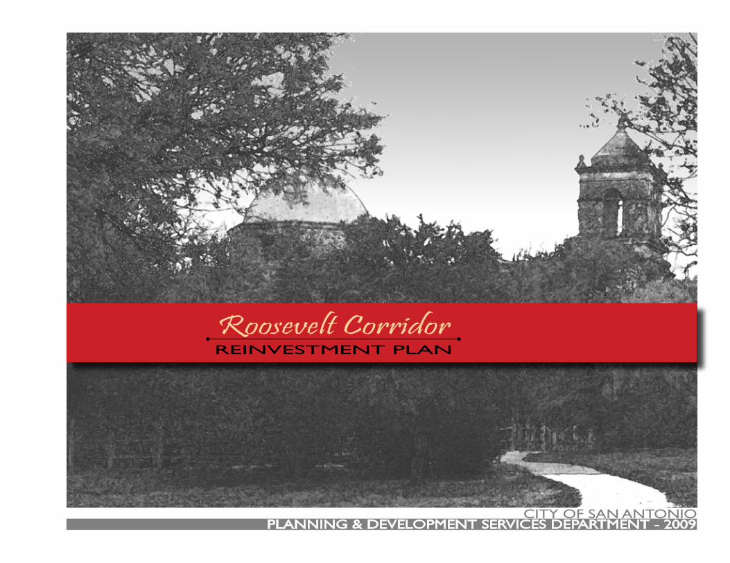
City of san antonio
Roosevelt CorridorREinVEstMEnt PLan
PLanning & dEVELoPMEnt sERViCEs dEPaRtMEnt - 2009
Roosevelt CorridorREinVEstMEnt PLan
this page intentionally left blank.
REinVEstMEnt PLanRoosevelt CorridorREinVEstMEnt PLan
City of San Antonio i
PREfaCEthe Roosevelt Corridor Reinvestment Plan provides a coordinated, multi-year program designed to spur reinvestment along Roosevelt av-enue. the Plan area extends from Lone star Boulevard to the north to Loop 410 to the south and includes the Mission drive-in tax increment Reinvestment Zone (tiRZ) area. the over arching goal of the Plan is to leverage the major drivers for the redevelopment of the Corridor - the Mission Reach of the san antonio River improvements Project and the redevelopment of the former Mission drive-in site. the Reinvestment Plan identifies infrastructure priority projects, community based initiatives, and tools for proactive land use planning. The Reinvestment Strate-gies and individual actions items were developed through a community-based process that included residents, business and property owners, neighborhood associations, public agency representatives, and design and finance professionals.
Phase i of the Reinvestment Plan was completed and presented to an audience of over 80 members of the community on May 12, 2009. Phase 2 of the Reinvestment Plan was presented to an audience of over 40 members of the community on July 28, 2009. the plan was unveiled sep-tember 16-17 at the Community development summit.
this Plan would not have been possible without the hard work and dedication of the members of the Planning team. the Planning team in-cluded members of the community who signed the memorandum of understanding and participated in one or more of the Planning team meetings thereby contributing to the completion of this Plan. the following individuals were members of the Planning team:
armando Cortez • diana L. alcoser • Rafael alcoser • Rosie M. anguiano • Candie Beltran • anita Blundy • Bill Bourne • William L. Bustillo • gabriel Cabral • Preciliana Cabral • ismael (Ernest) Calderón • Jamie Campbell • gerrit dinkla • Habib Erkan Jr. • Hope Evans • Ernest Hernan-dez • Vincent Huizar • Patricia Jay • Peter Krufchinski • Rene Luna • frank Martinez • alica McRae • garry J. nelson • garry P. nelson • James B. oliver • Jesse Pacheco • sal Ramos • gerald Ripps • Jason stevens • Chris stubbs • Michael a. tapia • Christine Vina • amelia Webb • danny Webb
through the dedication of individuals associated with the following organizations, and/or allowing the use of building space for community meetings and displays, contribution was also made to the building of this reinvestment plan:
Harlandale isd • national Park service • City of san antonio Parks & Recreation department
Many other people contributed to this plan through their participation in community meetings and work sessions. over 142 community members attended one or more of the 3 public meetings. in addition, several dozen staff members from various public agencies attended one or more of the Public Meetings and/or Planning team meetings. Many more people will participate in the implementation of this plan over the coming years...
Roosevelt CorridorREinVEstMEnt PLan
ii City of San Antonio
aCKnoWLEdgEMEnts
City OfficialsJulian Castro, MayorMary alice P. Cisneros, district 1ivy R. taylor, district 2Jennifer V. Ramos, district 3Philip a. Cortez, district 4david Medina Jr., district 5Ray Lopez, district 6Justin Rodriguez, district 7W. Reed Williams, district 8Elisa Chan, district 9John g. Clamp, district 10
Community Development Advisory Committee (CDAC)albert CarrisalezChristina Castano-PerezChristine drennonJennifer gonzalezdebra guerrerodominique Halabyignacio PerezJ. oscar Ramireznancy Rochasteven sano
City Managersheryl L. sculley
Deputy City ManagersPat digiovannia.J. Rodriguez
Assistant City Managersfrances a. gonzalezErik J. WalshPenny Postoak fergusont.C. Broadnaxsharon de la garza
Planning and Development Services DepartmentRoderick J. sanchez, aiCP, CBo; directorPatrick B. Howard, aiCP; assistant directorRichard L. Milk, aiCP; Community development Coordinatornina nixon-Mendez, aiCP; Planning ManagerMichael taylor, aiCP; senior Project PlannerLauren Edlund; Project Plannersidra Maldonado; Project PlannerJoe g. Mendoza; senior Management analystandrea gilles; senior Management analystKristine Egan; senior gis analystCory Lime; senior Real Estate specialistgary Edenburn; senior PlannerLoretta olison; senior PlannerJohn osten; senior PlannerRebecca Paskos; senior Plannertyler sorrells, aiCP; PlannerJared Enriquez, intern
This Reinvestment Plan was made possible through the support of City Officials, City Staff, and Community Participants dedicated to creating stronger communities.
REinVEstMEnt PLanRoosevelt CorridorREinVEstMEnt PLan
City of San Antonio iii
Technical Advisors
District 3 City Council OfficeRafael diaz,fernanda faresRosann sanchezgabe fariasorlando RamirezXamara Caballero
District 5 City Council OfficeMichael tejedaKatie nisbetRick Cuellardavid yanezElizabeth RiojasMonica Redmonsandra garza
Public Works departmentChristina de la CruzClaudia Zarazua
Capital improvement Management serviceJames LefloreMarcia shelf orlandiHenry Estradadaniel R. Rodriguez
aviation departmentJennifer Hogancampalex garciaBill telford
san antonio Police departmentVincent tristan
Housing & neighborhood services dept.adrian LopezJonathan LaneZenon solisVanessa McMahan
Historic Preservation Officeshanon WasielewskiKay Hindesyvette thomas
City Architect’s OfficeWilliam HensleyLisa McKenzie
san antonio Public LibraryRoberta sparksRich Walker
Harlandale independent school districtPete BarcenezKyle Blakeney
san antonio River authorityRobert Perezsteven schauerLuke HabenichtBrian Mast
san antonio Housing authorityBennie Bunkley iii
Kell-Munoz architectssteven tillotsongeof Edwards
Rialto architectsJim gray
national Park serviceJames oliverscott Bentleygregory smith
Via Metropolitan transitChristine VinaJason Rodriguez
san antonio Water systemMark schnurtracee Wulff
aCKnoWLEdgEMEnts
Roosevelt CorridorREinVEstMEnt PLan
iv City of San Antonio
CoMMUnity PaRtiCiPantsChris akeKillis almondRoberto anguianodale asheWayne asheJames L. BardenVirgina BarreraKevin Bartlettandrew BazanJesse Bazan Jr.norma Bernalanita Cabralisobel CalderónPreciliana C. CamposMargaret Carrisal frank ChapaBrian ChasnoffJeff Christianamanda CockrellJohn CroneRichard Crowdiana davilaLorena delganRichard douglassthelma douglassJerry EbnerMark EmbryBeau foyRonda galleyisabel garciaalejo garcia
sonia garciaRichard garcianorma garciaRichard B garciaRichard C. garciaLeonard J. gittinger, Jr.Juan gonzalezdebra guerreroisidoro gutierrezsolia gutierrezgib HafernickJesusa Hankssusie HanksWayne HawleyMartha HenryJennifer HerreraLucy HuerecaH.B. JavilinaRobin JohnstonRosalinda JohnstonRoy Juarezdave KoehlerJan KoehlerRaul LinoRaul LiraJoe Longoriadoris LopezJoy Lopezgrace MartinezLuis MartinezEarl Metts
Rodrigo Mirelestoni MoorehouseJoe naizerJulian navarroRene neiraJaime noriegaJean PachecoKris Patergardner PeavyMarisa Ponce de LeonMaria QuezadaCandelario RendonMaria C Rendonfelipe RodriguezRachel Rodriguezgerald RogersRufino Rosalesfrancisco salarBobbie scanioJustin scanioarnold schultzChris silvaWes sowellConnie stromLawrence stromsantiago talamantezMichael tesedadullabh thakorHetan thakorRalph thrasherRuth thrasher
teodoro M. torresJuan torresaurora ValekBrenda Vaupelterry VaupelPablo VillarealKurt WahrmundCarrie Wiggersstacia Willsglen Woodal ZaldivarRebecca LopezRick gutierrezarmando Cortezdiana L. alcoserRafael alcoserRosie M. anguianoCandie Beltrananita BlundyBill BourneWilliam L. Bustillogabriel CabralPreciliana Cabralismael (Ernest) CalderónJamie Campbellgerrit dinklaHabib Erkan Jr.Hope EvansErnest HernandezVincent HuizarPatricia Jay
Peter KrufchinskiRene Lunafrank Martinezalica McRaegarry J. nelsongarry P. nelsonJesse Pachecosal Ramosgerald RippsJason stevensChris stubbsMichael a. tapiaamelia Webbdanny Webb
REinVEstMEnt PLanRoosevelt CorridorREinVEstMEnt PLan
City of San Antonio v
taBLE of ContEnts
Contents
1: Introduction...................................................................1:7Plan Purpose ...........................................................................................................1:9Process .................................................................................................................. 1:10History .................................................................................................................. 1:12
2: Vision.............................................................................2:15south Central Community Plan...................................................................... 2:17stinson airport Vicinity Land Use Plan .......................................................... 2:20
3: Existing Conditions.....................................................3:23Population size and density ............................................................................ 3:26Median age .......................................................................................................... 3:27Educational attainment ..................................................................................... 3:28Median Household income .............................................................................. 3:29Poverty Level ...................................................................................................... 3:30neighborhood associations ............................................................................ 3:31Existing Use assessment .................................................................................. 3:32future Land Use ................................................................................................. 3:33Base Zoning ......................................................................................................... 3:34overlay Zoning ................................................................................................... 3:36Mobility ................................................................................................................ 3:37
4: Assets............................................................................4:39san antonio River improvements Project ................................................... 4:41district 3 Library & Mixed-Use Complex ................................................... 4:41Mission drive-in tiRZ ...................................................................................... 4:41sa Missions national Park .............................................................................. 4:41developable Land .............................................................................................. 4:42development Projects ...................................................................................... 4:42Community involvement ................................................................................. 4:43
5: Priorities.......................................................................5:45Quality of Life ..................................................................................................... 5:47
Land Use Management ..................................................................................... 5:50infrastructure...................................................................................................... 5:53improvement funds .......................................................................................... 5:54
6: Reinvestment Strategies.............................................6:55Infill & Reinvestment Policy ............................................................................. 6:57Corridor Reinvestment strategies ................................................................. 6:58
7: Reinvestment Strategy Action Matrix.......................7:65
Appendix: Overlay District Design Standards............. A:79
Roosevelt CorridorREinVEstMEnt PLan
vi City of San Antonio
Maps
Reinvestment Plan area .................................................................... 1:10adopted Plans ..................................................................................... 2:17Population density ............................................................................. 3:26Median age .......................................................................................... 3:27Educational attainment ..................................................................... 3:28Median Household income .............................................................. 3:29Poverty Level ....................................................................................... 3:30neighborhood associations ............................................................ 3:31Existing Land Use ............................................................................... 3:32future Land Use ................................................................................. 3:33Base Zoning ......................................................................................... 3:34Rezoning Recommendations ........................................................... 3:35overlay Zoning ................................................................................... 3:36Mobility ................................................................................................. 3:37River Connections ............................................................................. 6:59
taBLE of ContEntsMap Disclaimer
the City of san antonio has attempted to assure the accuracy of this data for its internal uses and for no other purposes. the City of san antonio did not develop this data as a commercial produce. Consequently, the City of san antonio makes no warranty, representation or guaranty as to the content, sequence, accuracy, timeliness or completeness of all or any part of this data. the users should not rely on the data provided for any reason unless and until the user independently verifies the accuracy of any such data to the user’s personal satisfaction. The City of san antonio explicitly disclaims any representation and warranties, including, without limitation, the implied warranties of merchantability and fitness for a particular purpose. the City of san antonio assumes no liability for any errors, omissions or inaccuracies in the data provided regardless of how caused. the City of san antonio assumes no liability for any decision made or actions taken or not taken by the user of this data in reliance upon any data furnished hereunder.
the use of this data indicates your unconditional acceptance of all risks associ-ated with the use of this data.
Printing Information
this document is formatted for double-sided landscape printing on letter size paper.
Copies of this plan may be obtained for a fee at:City of san antonio
Cliff Morton development & Business services Center1901 south alamo streetsan antonio, tX 78204

REinVEstMEnt PLanRoosevelt CorridorREinVEstMEnt PLan
intRodUCtionCHaPtER 1:

Roosevelt CorridorREinVEstMEnt PLan
this page intentionally left blank.
City of San Antonio 1:9
REinVEstMEnt PLanRoosevelt CorridorREinVEstMEnt PLan
1: intRodUCtion
This plan provides a detailed recipe for the redevelopment of the Roosevelt Corridor. this plan was developed through a communi-ty-based process with technical assistance provided by public & pri-vate financing professionals, authorities in public policy, engineers, architects, and planners.
The over-arching goal of this plan is to encourage re-investment in the Roosevelt Corridor. achieving this will require the following actions:
Leverage River Improvements & Mission Drive-In RedevelopmentInvest in drainage, street and sidewalk infra-structurePhase out high intensity commercial and industrial zoningAdopt unifying design standards for new con-structionLaunch community-based initiatives to im-prove quality of lifeLink existing business & property owners with funding sourcesCreate investment opportunities
•
•
•
•
•
•
•
Plan Purpose
The Roosevelt Corridor has long been overlooked for both public and private investment despite the fact that the Corridor connects
some of the City’s most important recreational, historical and cul-tural assets. the Roosevelt Corridor links downtown to the south-ern edge of the City and is connected to the san antonio River by path and proximity, even if no longer connected in identity. despite the proximity of Roosevelt to the san antonio River, the Corridor has lost all contact with this important asset with many not realizing just how close the Corridor is to the River that has sustained life on the southside for hundreds of years. While paralleling the general north-south flow of the River, the Roosevelt Corridor connects a series of riverside parks, a municipal golf course, provides access to the historic missions, and is the arrival and departure gateway for travelers utilizing the recently upgraded stinson Municipal airport. the current condition of the corridor, caused by decades of neglect and disinvestment, betrays its riverside location and its role con-necting these resources.
the extension of the san antonio River improvements Project be-yond downtown and into the heart of the southside promises to end a decades long period marked by neglect and disinvestment. Reinvigorating the River through eco-system restoration, flood control upgrades, recreational enhancements and aesthetic im-provements provides motivation for rethinking the role and func-tion of the Roosevelt Corridor. When combined with the publicly- and privately-funded redevelopment of the former Mission drive-in site into the new district 3 branch library and mixed-use complex, these projects have the potential to generate opportunities for the redevelopment of the entire Roosevelt Corridor. this Reinvest-ment Plan was conceived as a way to utilize the publicly funded improvements to the River and the Mission drive-in site to focus and coordinate public and private sector investment along the en-tire Roosevelt Corridor to ensure these projects are not islands unto themselves, but rather are integrated into a larger context of
1:10 City of San Antonio
Roosevelt CorridorREinVEstMEnt PLan
functional and aesthetic enhancements.
Process
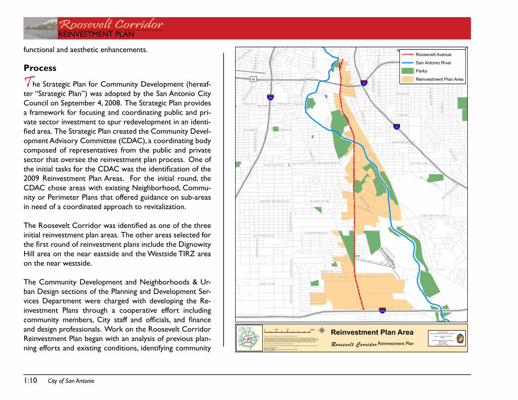
The strategic Plan for Community development (hereaf-ter “strategic Plan”) was adopted by the san antonio City Council on september 4, 2008. the strategic Plan provides a framework for focusing and coordinating public and pri-vate sector investment to spur redevelopment in an identi-fied area. The Strategic Plan created the Community Devel-opment advisory Committee (CdaC), a coordinating body composed of representatives from the public and private sector that oversee the reinvestment plan process. one of the initial tasks for the CDAC was the identification of the 2009 Reinvestment Plan areas. for the initial round, the CdaC chose areas with existing neighborhood, Commu-nity or Perimeter Plans that offered guidance on sub-areas in need of a coordinated approach to revitalization.
The Roosevelt Corridor was identified as one of the three initial reinvestment plan areas. the other areas selected for the first round of reinvestment plans include the Dignowity Hill area on the near eastside and the Westside tiRZ area on the near westside.
the Community development and neighborhoods & Ur-ban design sections of the Planning and development ser-vices department were charged with developing the Re-investment Plans through a cooperative effort including community members, City staff and officials, and finance and design professionals. Work on the Roosevelt Corridor Reinvestment Plan began with an analysis of previous plan-ning efforts and existing conditions, identifying community
PRESA
STS
FLOR
ESST
S
RO
OS
EV
ELT
AV
PLE
AS
AN
TON
RD
STEVES AV
CO
MM
ER
CIA
LAV
FAIR AV
GE
VE
RS
ST
S
MISSIO
NR
D
GOLIAD
RD
CLA
RK
AV
RIGSBY AV
NE
WB
RA
UN
FELS
AVS
WA
LTE
RS
ST
S
HA
CK
BE
RR
YS
TS
ASHLEY RD
MILITARY DR SE
GILLETTE BV
HOT WELLS BV
MALONE ST W
SOUTHCROSS W
HUTCHINS PLACE
MO
UR
SU
ND
BV
THEO AV E
SOUTHCROSS BV E
THEO AV W
MILITARY DR SW/LOOP 13
DIVISION AV
NEW BRAUNFEL S
PR
OB
AN
DT
ST
BRAZ
OS
STS
FRIOCITY RD
HUTCHINS PLACE E
PECANVALLE
Y DR
SE MILITARY DR/LOOP 13
NOGALIT
OSST
STM
AR
YSST
S
SOUTHCROSS E
MILITARY DR SW
OLI
VE
ST
S
SOUTHCROSS BV E
NOGALIT
OSST
THEO AV W
CO
MM
ER
CIA
LAV
PRO
BAN
DT
ST
MO
UR
SU
ND
BV
MISSIONRD
DIVISION AV
MISSIONRD
OLI
VE
ST
S
§̈¦410
§̈¦10
§̈¦35
§̈¦37
£¤90
µData Source: City of San Antonio Enterprise GIS, Bexar Metro 911, Bexar Appraisal District
"This Geographic Information System Product received from the City of San Antonio is provided "as is" without warranty of any kind, and theCity of San Antonio expressly disclaims all expressed and implied warranties, including but not limited to the implied warranties of merchantability andfitness for a particular purpose. The City of San Antonio does not warrant, guarantee, or make any representations regarding the use, or the resultsof the use, of the information provided to you by the City of San Antonio in terms of correctness, accuracy, reliability, timeliness or otherwise.The entire risk as to the results and performance of any information obtained from the City of San Antonio is entirely assumed by the recipient."
"Please contact the City of San Antonio Department for specific determinations."
City of San Antonio Planning Department GIS Manager: Dale Woodruff, [email protected]. Maps may be ordered at (210) 207-7873.
Map Created by: Michael Taylor,AICPMap Creation Date: May 2009Map File Location: K:\Neighborhoods\OVERLAY DISTRICTS\Studies\Roosevelt MetropolitanPDF Filename:AdoptedPlans
Roosevelt Corridor
Reinvestment Plan Area0 0.5 10.25 MilesCity of San Antonio
Planning & Development Services Department
Roderick J. Sanchez, AICP, CBODirector
Cliff Morton Development and BuisinessServices Center1901 S. Alamo
San Antonio, TX 78204
Roosevelt Avenue
San Antonio River
Parks
Reinvestment Plan Area
Reinvestment Plan
City of San Antonio 1:11
REinVEstMEnt PLanRoosevelt CorridorREinVEstMEnt PLan
stakeholders and creating a work plan.
an area wide rezoning was recommended by staff early in the pro-cess as a way to implement the future land use plan, adopted as a component of the City’s Master Plan, and phase-out non-contribut-ing uses. a zoning overlay district with unique site and building de-sign standards also seemed vital to creating a unique identity for the Corridor and ensuring future construction respected the historical assets and forthcoming public investment in the area. the base re-zoning and overlay district creation and designation processes were initiated by City Council Resolution 2009-03-05-0005R approved on March 5, 2009.
the general study area boundaries include the east and west sides of Roosevelt avenue beginning at the terminus of st. Mary’s street to the north (near the intersection of Lone star Boulevard) and ending at Loop 410 to the south. the Corridor is approximately 5.8 miles long. there are approximately 340 parcels with frontage on Roosevelt avenue that fall within the boundaries of the Corridor overlay district.
the Roosevelt Corridor Planning team served a vital role in the de-velopment and implementation of the Reinvestment Plan. Business and property owners, representatives from City departments and public agencies (including Harlandale school districts san antonio Water system (saWs), san antonio River authority (saRa), san antonio Housing authority (saHa)), engineers, planning and design professionals, public and private financing experts, and other stake-holders involved in past planning efforts for the area were invited to participate on the Planning team. after an initial information ses-sion held on March 3, 2009, the Planning Team solidified and began a regular meeting schedule. Planning team meetings were held on
the following dates with the following topics:
March 24 - introduction, Visioningapril 7 - Reinvestment Priorities iapril 21 - Reinvestment Priorities iiJune 2 - overlay district design standards iJune 23 - overlay district design standards iiJuly 7 - overlay district design standards iii
the Planning team’s work program included visioning exercises, a needs assessment, project prioritization, and implementation strat-egies. the Planning team reported back to the community at-large and solicited comment during regularly scheduled public meetings. Public meetings were held on the following dates:
March 3 - Planning team information sessionMay 12 - Reinvestment Plan Phase iJuly 28 - Reinvestment Plan Phase iiseptember 8 - open House sessions
1:12 City of San Antonio
Roosevelt CorridorREinVEstMEnt PLan
History
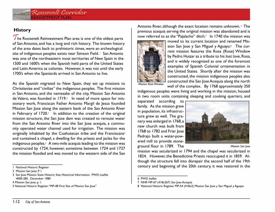
The Roosevelt Reinvestment Plan area is one of the oldest parts of san antonio, and has a long and rich history. the known history of the area dates back to prehistoric times, were an archeological site of indigenous peoples exists near stinson field. 1 san antonio was one of the northeastern most territories of new spain in the 1500 and 1600’s when the spanish held parts of the United states and Latin america as colonies. However, it was not until the early 1700’s when the spaniards arrived in san antonio to live.
as the spanish migrated to new spain, they set up missions to Christianize and “civilize” the indigenous peoples. The first mission in san antonio, and the namesake of the city, Mission san antonio de Valero, was founded in 1719.2 in need of more space for mis-sionary work, franciscan father antonio Margil de Jesus founded Mission san Jose along the eastern bank of the san antonio River in february of 1720.3 in addition to the creation of the original mission structure, the san Jose dam was created to reroute water from the san antonio River into the san Jose acequia, a commu-nity operated water channel used for irrigation. the mission was originally inhabited by the Coahutecan tribe and the franciscans4 and contained a chapel, a dwelling for the priests and jacles for the indigenous peoples.5 a two-mile acequia leading to the mission was constructed by 1724, however, sometime between 1724 and 1727 the mission flooded and was moved to the western side of the San
1 national Historic Register2 Mission san Jose, P. 13 San Jose Mission State Historic Site; Historical Information. PWD Leaflet 4000-285. december 19804 Mission san Jose, p. 1.5 national Historic Register. “MP-48 first site of Mission san Jose”
antonio River, although the exact location remains unknown. 6 the previous acequia serving the original mission was abandoned and is now referred to as the “Pajalache” ditch.7 in 1740 the mission was
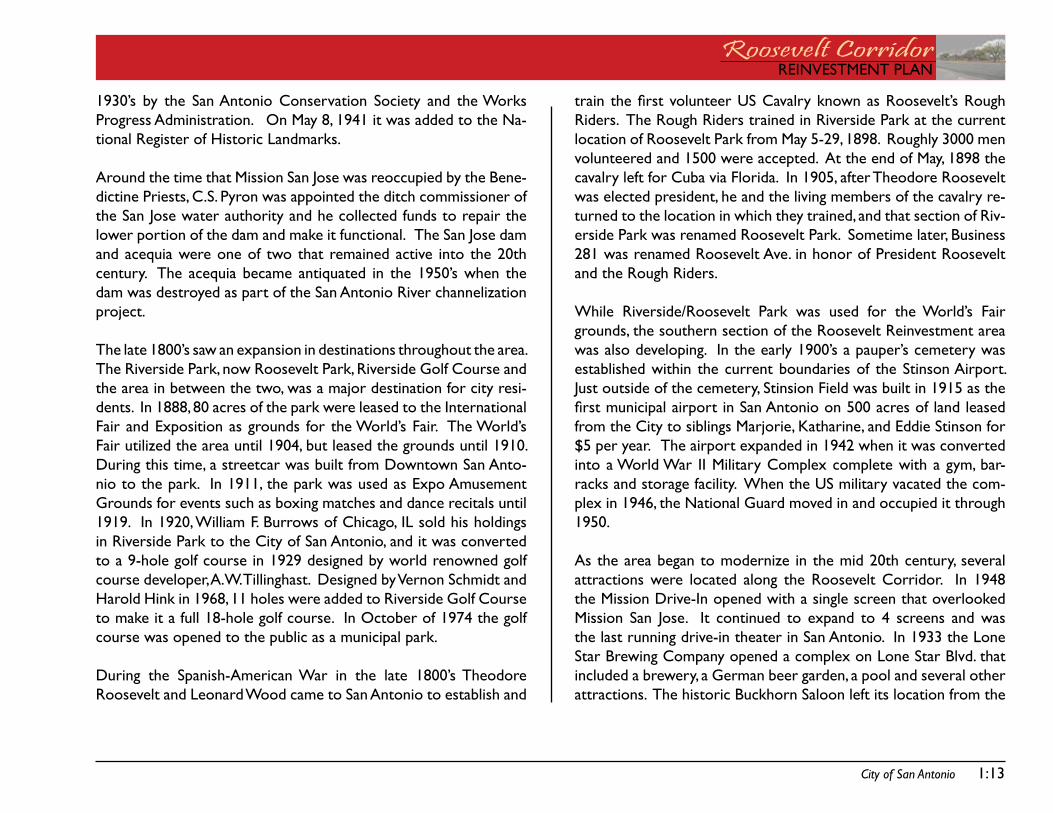
moved to its current location and renamed Mis-sion san Jose y san Miguel y aguayo.8 the cur-rent mission features the Rosa (Rose) Window by Pedro Huizar as a tribute to his lost love, Rosa, and is widely recognized as one of the foremost examples of spanish Colonial ornamentation in the United states. shortly after the mission was constructed, the mission indigenous peoples also constructed the san Jose acequia along the north wall of the complex. By 1768 approximately 350
indigenous peoples were living and working in the mission, housed in two room units containing sleeping and cooking quarters, and separated according to family. as the mission grew in population, its infrastruc-ture grew as well. the gra-nary was enlarged in 1768, a new church was built from 1768 to 1782 and friar Jose Pedrajo built a water-pow-ered mill to provide stone-ground flour in 1789. The mission was secularized in 1794 and the chapel was secularized in 1824. However, the Benedictine Priests reoccupied it in 1859. al-though the structure fell into disrepair the second half of the 19th century and beginning of the 20th century, it was restored in the
� PWD leaflet7 nHR MP-67 (418x267) san Jose acequia8 national Historic Register MP-54 (418x3) Mission san Jose y san Miguel y aguayo
Mission San Jose
Mission Rose Window
City of San Antonio 1:13
REinVEstMEnt PLanRoosevelt CorridorREinVEstMEnt PLan
1930’s by the san antonio Conservation society and the Works Progress administration. on May 8, 1941 it was added to the na-tional Register of Historic Landmarks.
around the time that Mission san Jose was reoccupied by the Bene-dictine Priests, C.s. Pyron was appointed the ditch commissioner of the san Jose water authority and he collected funds to repair the lower portion of the dam and make it functional. the san Jose dam and acequia were one of two that remained active into the 20th century. the acequia became antiquated in the 1950’s when the dam was destroyed as part of the san antonio River channelization project.
the late 1800’s saw an expansion in destinations throughout the area. the Riverside Park, now Roosevelt Park, Riverside golf Course and the area in between the two, was a major destination for city resi-dents. in 1888, 80 acres of the park were leased to the international fair and Exposition as grounds for the World’s fair. the World’s fair utilized the area until 1904, but leased the grounds until 1910. during this time, a streetcar was built from downtown san anto-nio to the park. in 1911, the park was used as Expo amusement grounds for events such as boxing matches and dance recitals until 1919. in 1920, William f. Burrows of Chicago, iL sold his holdings in Riverside Park to the City of san antonio, and it was converted to a 9-hole golf course in 1929 designed by world renowned golf course developer, a.W. tillinghast. designed by Vernon schmidt and Harold Hink in 1968, 11 holes were added to Riverside golf Course to make it a full 18-hole golf course. in october of 1974 the golf course was opened to the public as a municipal park.
during the spanish-american War in the late 1800’s theodore Roosevelt and Leonard Wood came to san antonio to establish and
train the first volunteer US Cavalry known as Roosevelt’s Rough Riders. the Rough Riders trained in Riverside Park at the current location of Roosevelt Park from May 5-29, 1898. Roughly 3000 men volunteered and 1500 were accepted. at the end of May, 1898 the cavalry left for Cuba via florida. in 1905, after theodore Roosevelt was elected president, he and the living members of the cavalry re-turned to the location in which they trained, and that section of Riv-erside Park was renamed Roosevelt Park. sometime later, Business 281 was renamed Roosevelt ave. in honor of President Roosevelt and the Rough Riders.
While Riverside/Roosevelt Park was used for the World’s fair grounds, the southern section of the Roosevelt Reinvestment area was also developing. in the early 1900’s a pauper’s cemetery was established within the current boundaries of the stinson airport. Just outside of the cemetery, stinsion field was built in 1915 as the first municipal airport in San Antonio on 500 acres of land leased from the City to siblings Marjorie, Katharine, and Eddie stinson for $5 per year. the airport expanded in 1942 when it was converted into a World War ii Military Complex complete with a gym, bar-racks and storage facility. When the Us military vacated the com-plex in 1946, the national guard moved in and occupied it through 1950.
as the area began to modernize in the mid 20th century, several attractions were located along the Roosevelt Corridor. in 1948 the Mission drive-in opened with a single screen that overlooked Mission san Jose. it continued to expand to 4 screens and was the last running drive-in theater in san antonio. in 1933 the Lone star Brewing Company opened a complex on Lone star Blvd. that included a brewery, a german beer garden, a pool and several other attractions. the historic Buckhorn saloon left its location from the
1:14 City of San Antonio
Roosevelt CorridorREinVEstMEnt PLan
corner of Houston and flores streets and moved into the Lone star complex in 1957. in 1996 the Lone star Brewery ceased pro-duction and the complex was closed. in 1974 the Riverside golf Course was renovated to include 18 holes and reopened as a mu-nicipal golf course.
CURREntLy:
in 2007 the Mission drive-in closed permanently and the City of san antonio purchased the land to establish a public library and commercial area. the original screen has been maintained and will periodically be utilized. Mission san Jose is part of the national Park service’s Mission trail and is open to visitors. the Roman Catholic Church holds mass in the chapel several times per week. Roosevelt Park is currently undergoing renovations with city bond money to include a playground, pool and community center. the stinson air-port is currently undergoing Phase i of ii in renovations that include new runways, a community meeting room and a café open to the public; Phase i is slated to be completed in 2015. the san anto-nio River is undergoing restoration lead by the san antonio River authority to restore it to its original natural state and the project is slated to be completed in 2014. the City of san antonio Parks and Recreation department created and maintains the Mission trail that runs through the reinvestment plan area that provides a walk-ing, jogging and bicycle path along the san antonio Missions.
REinVEstMEnt PLanRoosevelt CorridorREinVEstMEnt PLan
VisionCHaPtER 2:
Roosevelt CorridorREinVEstMEnt PLan
this page intentionally left blank.
City of San Antonio 2:17
REinVEstMEnt PLanRoosevelt CorridorREinVEstMEnt PLan
South Central
Highlands
Stinson Airport Vicinity
City South
Arena District
Nogalitos/ South Zarzamora
Pecan Valley
LavacaDowntownGuadalupe Westside
PR
ES
AS
TS
FLOR
ESST
S
RO
OS
EV
ELT
AV
PLE
AS
AN
TON
RD
STEVES AV
CO
MM
ER
CIA
LAV
FAIR AV
GE
VE
RS
ST
S
MISSIO
NR
D
GOLIAD
RD
CLA
RK
AV
RIGSBY AV
NE
WB
RA
UN
FELS
AVS
WA
LTE
RS
ST
S
HA
CK
BE
RR
YS
TS
ASHLEY RD
MILITARY DR SE
GILLETTE BV
HOT WELLS BVSOUTHCROSS W
HUTCHINS PLACE
MO
UR
SU
ND
BV
THEO AV E
SOUTHCROSS BV E
THEO AV W
MILITARY DR SW/LOOP 13
DIVISION AV
NEW BRAUNFEL S
PR
OB
AN
DT
ST
BR
AZO
SS
TS
HUTCHINS PLACE E
PECANVALLE
Y DR
SE MILITARY DR/LOOP 13
NOGALIT
OSST
SOUTHCROSS E
MILITARY DR SW
OLI
VE
ST
S
SOUTHCROSS BV E
MO
UR
SU
ND
BV
CO
MM
ER
CIA
LAV
PRO
BAN
DT
ST
MISSIONRD
THEO AV W
DIVISION AV
MISSIONRD
OLI
VE
ST
S
§̈¦410
§̈¦10
§̈¦35
§̈¦37
£¤90
µData Source: City of San Antonio EnterpriseGIS, Bexar Metro 911, Bexar Appraisal District
"This Geographic InformationSystem Product receivedfrom the City of SanAntonio is provided "as is" without warranty of any kind, and theCity of San Antonio expressly d isclaims all expressed and impl ied warranties, includingbut not limited to the impliedwarranties of merchantabili ty andfitness for a particular purpose. The Ci ty of SanAntoniodoes not warrant, guarantee, or makeany representations regarding the use, or the resul tsof theuse, of the information provided toyouby theCity of San Antonio in terms of correctness, accuracy, rel iabi lity, timeliness or otherwise.The entire risk as tothe results andperformance of any information obtained from theCi ty of San Antonio is enti re ly assumed by therecipient."
"Please contact the Ci ty of SanAntonioDepartment for speci fic determinations."
City of San Antonio Planning Department GIS Manager: Dale Woodruff, [email protected]. Maps may be orderedat (210) 207-7873.
Map Created by: Michael Taylor,AICPMap CreationDate: May 2009Map File Location: K:\Neighborhoods\OVERLAY DISTRICTS\Studies\Roosevel t MetropolitanPDF Filename: AdoptedPlans
Roosevelt Corridor
Adopted Plans0 0.5 10.25 MilesCity of San Antonio
Planning & Development Services Department
Roderick J. Sanchez, AICP, CBODirector
Cliff Morton Development and Buis inessServices Center1901 S. Alamo
San Antonio, TX 78204
Roosevelt Avenue
Proposed Corridor Overlay District
San Antonio River
Reinvestment Plan
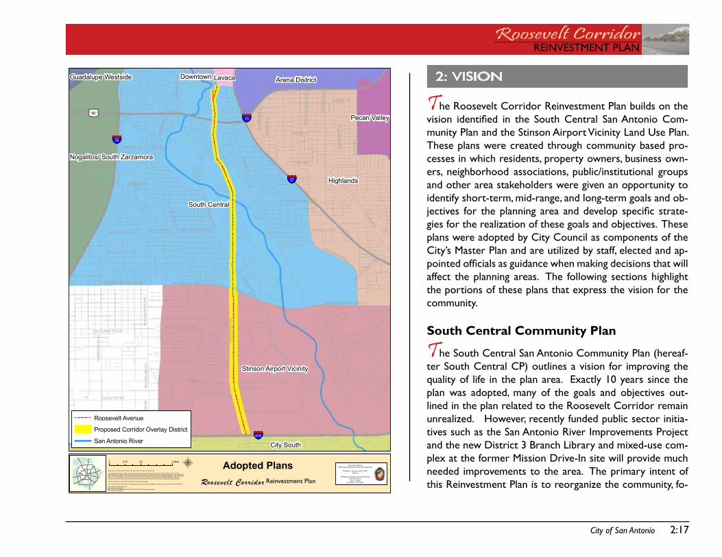
2: Vision
The Roosevelt Corridor Reinvestment Plan builds on the vision identified in the South Central San Antonio Com-munity Plan and the stinson airport Vicinity Land Use Plan. these plans were created through community based pro-cesses in which residents, property owners, business own-ers, neighborhood associations, public/institutional groups and other area stakeholders were given an opportunity to identify short-term, mid-range, and long-term goals and ob-jectives for the planning area and develop specific strate-gies for the realization of these goals and objectives. these plans were adopted by City Council as components of the City’s Master Plan and are utilized by staff, elected and ap-pointed officials as guidance when making decisions that will affect the planning areas. the following sections highlight the portions of these plans that express the vision for the community.
South Central Community Plan
The south Central san antonio Community Plan (hereaf-ter south Central CP) outlines a vision for improving the quality of life in the plan area. Exactly 10 years since the plan was adopted, many of the goals and objectives out-lined in the plan related to the Roosevelt Corridor remain unrealized. However, recently funded public sector initia-tives such as the san antonio River improvements Project and the new district 3 Branch Library and mixed-use com-plex at the former Mission drive-in site will provide much needed improvements to the area. the primary intent of this Reinvestment Plan is to reorganize the community, fo-
2:18 City of San Antonio
Roosevelt CorridorREinVEstMEnt PLan
cus and coordinate the delivery of city resources and, find oppor-tunities to leverage this public sector investment to improve the overall conditions in the Roosevelt avenue corridor to help the community achieve many of the primary goals outlined in the south Central CP.
the south Central CP was adopted by City Council on august 19, 1999. an update to the land use component of the Plan was ap-proved by City Council on october 26, 2005. this update was conducted in accordance with the update procedures outlined in UdC 35-420. the south Central planning area is bound by s. alamo Street and the Union Pacific Railroad tracks to the north, IH-35 to the west, sW Military drive to the south, and iH-37 to the east. the plan area includes approximately 12 square miles with a popu-lation of approximately 55,000 according to the 2000 Us Census.
the south Central CP addresses four basic elements: neighbor-hood development/environment, community facilities/quality of life, transportation networks, and plan implementation. the 4 major goals that came out of this planning process are included below:
Maintain and build on the old-fashioned neighborhood character of south Central san antonio.support and enhance the area’s community facilities to improve quality of life.develop the transportation networks necessary to make community facilities and businesses accessible by car, public transit, bike and foot.improve the overall quality of life in south Central san antonio through the development and implementation of the south Central CP.
•
•
•
•
Collectively, these goals present a long term vision for improving the quality of life in the south Central CP planning area. in the following section, the objectives and strategies included within the 4 elements of the Plan that are particularly relevant to the Roos-evelt Corridor are outlined. Each section contains a commentary explaining the relevance of these objectives and strategies to the Reinvestment Plan.
neighborhood development/ Environment
the neighborhood development/ Environment chapter focuses on strategies to develop and enhance the community’s commercial corridors, encourage the rehabilitation and construction of housing, and create a healthy environment for families and businesses.
objective 1 - Economic Development: develop and enhance the community’s commercial corridors by improving streetscape appearances and recruiting businesses to employ and provide goods/services to residents.
strategy 1.1 - Economic Development: improve the quality of commercial corridors including south flores street, south Presa street, and Roosevelt avenue.
strategy 1.2 - Economic Development: attract investors for vacant land and buildings available for development.
This Redevelopment Plan focuses on a sub-area identified within the south Central CP - the Roosevelt Corridor. the River improve-ments and the new district 3 Library have elevated the Roosevelt Corridor to a higher priority for economic development. With this reinvestment initiative, Roosevelt could become the preeminent corridor in the south Central CP Plan area and a demonstration
City of San Antonio 2:19
REinVEstMEnt PLanRoosevelt CorridorREinVEstMEnt PLan
model for future corridor redevelopment efforts.
Community facilities/ Quality of Life
the Community facilities/ Quality of Life chapter focuses on strat-egies to enhance the community’s Missions, parks and the san anto-nio River, increase community identity, improve overall community appearance, support existing community facilities, and maintain a safe environment.
objective 1 - Parks and Recreation: Enhance and improve the Missions, parks and the san antonio River.
strategy 1.1 - Hike & Bike Trail System: Expand the hike and bike trail/ linear park system to connect all parts of the city along waterways (including the san antonio River)
strategy 1.3 - Cleanliness & Safety: Enhance the san antonio River and area parks’ cleanliness and safety.
Many of the major action steps under this objective focus on the need to secure support and funding for improvements for the long neglected portion of the san antonio River within the Plan area. this concern will be addressed by the substantial improvements currently being made or planned for the san antonio River as part of the Mission Reach of the River improvements Project. this col-laborative effort by the City of san antonio, Bexar County, the army Corps of Engineers and the san antonio River foundation includes ecosystem restoration, amenities, recreational improvements and flood control improvements. The San Antonio River Authority (saRa) is providing project and technical management. this plan contains strategies for leveraging these improvements to support other investment opportunities within the Corridor.
objective 2 - Community Identity: Build on the strength of good neighbors and increase participation to make community improve-ments happed.
strategy 2.1 - Community Identity: increase community iden-tity through publicity, education, logos/icons, and the forma-tion of community/ neighborhood groups.
objective 3 - Community Appearance: Enhance the overall community appearance.
strategy 3.1 - Community Projects:. initiate community proj-ects to improve community appearance.
strategy 3.2 - Tree Planting:.Plant more trees in the south Central san antonio area.
objective 4 - Community Facilities: support and enhance exist-ing community facilities.
objective 5 - Community Safety: increase security and maintain a safe environment.
objectives 2 through 5 include initiatives designed to improve qual-ity of life and perception. the community has not received the support necessary to fully implement the quality of life and percpe-tion-enhancing initiatives identified. The Reinvestment Plan aligns support and funding to launch major community-based initiatives, establish design standards for new construction, and design and build major infrastructure projects, all of which are designed to im-prove the quality of life and enhance the perception of the Roos-
2:20 City of San Antonio
Roosevelt CorridorREinVEstMEnt PLan
evelt Corridor.
transportation networks
the transportation networks Plan Chapter focuses on strategies to improve the quality and maintenance of area streets, curbs, side-walks, enhance the area’s infrastructure, improve accessibility to and from highways, provide accessible, convenient transit, provide for smooth traffic flow at railroad crossings and work to address rail-road noise concerns while maintaining safety.
objective 1 - Street & Sidewalk Conditions: improve the qual-ity and maintenance of area streets, curbs, and sidewalks.
strategy 1.1 - Street & Sidewalks Construction/ Repair: Enhance street and sidewalk conditions.
strategy1.2 - Street & Sidewalk Cleanliness:.Maintain the clean-liness of neighborhood streets/ arterials/ sidewalks.
objective 2 - Infrastructure: Enhance the area’s infrastructure.
strategy 2.1 - Infrastructure:. address drainage problems within the area.
objective 4 - Public Transit: Provide accessible, convenient transit for area residents.
strategy 4.1 - Public Transit: support Via’s efforts to provide a high level of quality service along transit corridors.
objectives 1, 2 and 4 include infrastrucure design, construction, maintenance, and operation objectives. the Reinvestment Plan
prioritizes infrastructure needs, links individual projects to funding sources, and establishes schedules for project completion.
Plan implementation
the Plan implementation Chapter focuses on strategies to organize a Community action group to ensure implementation of the south Central san antonio Community Plan.
objective 1 - Implementation: Ensure implementation of the goals, objectives, strategies, and major action steps included in the south Central CP.
strategy 1.1 - Implementation: develop a coordinating and action group to work on achieving the goals of the south Central CP.
the Reinvestment Plan is a tool for implementation. although the Reinvestment Plan focuses on the Roosevelt Corridor, the benefits of reinvestment along this Corridor can be expected to have pos-tive effects on the larger community and will serve as a template for the redevelopment of the other corridors in the south Central CP Plan area.
Stinson Airport Vicinity Land Use Plan
The stinson airport Vicinity Land Use Plan (hereafter “stinson Plan”) was developed primarily to promote land uses within the Plan area that are compatible with the airport’s operations and public safety. However, the plan also addresses the area’s neighborhoods, economic development, and cultural and environmental resources to promote future sustainability. from this plan comes a vision for the southern section of the Reinvestment Plan area.
City of San Antonio 2:21
REinVEstMEnt PLanRoosevelt CorridorREinVEstMEnt PLan
the stinson Plan was adopted by the san antonio City Council on april 2, 2009. the planning area is approximately 10.2 square miles bound by sW and sE Military drive on the north, iH-37 on the east, Loop 410 on the south and Pleasanton Road, gladnell avenue, and Loleta street on the west. stinson airport is contained on a 310-acre site centered in the plan area and serves at the general aviation reliever to san antonio international airport. Roosevelt avenue is an important arterial in the plan area because it provides vehicular access to the airport and connects it with the greater planning area. the population of the planning area is 20,227 according to the 2000 Us Census. the stinson Plan contains three main chapters: Land Use, transportation & gateway image, and implementation. the goals and objectives outlined in the Land Use and transportation & gateway image chapters form the overall vision for the area. the implementation Chapter includes the action steps needed to imple-ment the Stinson Plan. The five major goals that emerged from the planning process are:
Protect the quality of life of residents including health, safety and welfareEncourage economic growth that enhances airport opera-tions and developmentimprove multi-modal transportation systems and capacity to serve the airport and its vicinityEncourage a unique experience for airport patrons by cre-ating gateways and enhancing the airport vicinity’s image through urban designimplement land use strategies and transportation improve-ments in a coordinated, phased process.
Collectively, these goals present a long term vision for the improve-
•
•
•
•
•
ment of the planning area. the plan includes objectives for each of these goals. the following sections contain a more in-depth review of the specific objectives outlined in the Stinson Plan that are rele-vant to the redevelopment of the Roosevelt avenue Corridor. Each section contains a commentary explaining the relevance of these objectives and strategies to the Reinvestment Plan.
Land Use goals and objectives
the Land Use goals and objectives chapter focuses on objectives designed to protect the quality of life of existing and future resi-dents while also encouraging economic growth that enhances air-port operations and surrounding development.
objective 1.2 - Land Use Compatibility: discourage develop-ments of incompatible uses on vacant land
objective 2.1 - Improve Airfront Commercial Property: Up-grade and enhance airfront commercial property that is declining, is currently vacant, or is underutilized.
objective 2.2 - Commercial Encroachment: Encourage com-mercial development that respects the integrity of existing residen-tial development.
This Reinvestment Plan includes the use of specific zoning tools to ensure land use compatibility, protect established residential neigh-borhoods from commercial encroachment, and ensure new con-struction is unified and reflects the historic character and substan-tial public investment in the area. these tools will be used not just in the stinson Plan area, but throughout the Corridor to enhance the built environment and elevate development potential.
2:22 City of San Antonio
Roosevelt CorridorREinVEstMEnt PLan
nodes, short to medium block lengths, transit routes every half-mile, two- or four- lane streets with a raised median, wide, continuous sidewalks, appropriate buffering from traffic, small scale buildings, and safe and comfortable places to wait. the Reinvestment Plan includes the use of specific zoning tools and community based ini-tiatives to enhance urban design and create a sense of place.
transportation & gateway image
the transportation & gateway image Chapter addresses issues of mobility, accessibility, and livability as they relate to transportation.
objective 3.1 - Street & Highway Improvements: Maintain and improve the interstate/ Highway system, major arterials, and local streets as warranted.
Specific recommended improvements include building/improving concrete sidewalks with accessible ramps along Roosevelt avenue.
objective 3.2 - Improve Multi-Modal Systems: Maintain and improve the multi-modal systems including bus, bicycle, and pedes-trian access.
Specific recommended improvements include the installation of weather protection shelters, sidewalks, and concrete pads at the busiest bus stops.
objectives 3.1 and 3.2 include enhancements to the existing infra-structure in the stinson Plan area. the Reinvestment Plan prioritiz-es infrastructure needs, links individual projects to funding sources, and establishes schedules for project completion.
objective 4.1 - Place Making: Create a sense of place that repre-sents local culture and heritage.
objective 4.2 - Urban Design: develop a design theme for the airport and its adjacent corridors.
Specific elements that are recommended to encourage pedestrian and transit travel include: mix of land uses, medium and high density
REinVEstMEnt PLanRoosevelt CorridorREinVEstMEnt PLan
EXisting ConditionsCHaPtER 3:

Roosevelt CorridorREinVEstMEnt PLan
this page intentionally left blank.
City of San Antonio 3:25
REinVEstMEnt PLanRoosevelt CorridorREinVEstMEnt PLan
3: EXisting Conditions
this chapter includes an analysis of existing conditions within the Corridor. these conditions serve as benchmarks and reveal areas where deficiencies exist. These deficiencies are targeted for im-provement as part of this Reinvestment Plan. these benchmarks should be tracked over time to determine if the Reinvestment Plan strategies and individual initiatives are successful in accomplishing the overall goals.
in addition to benchmarking, these existing conditions also serve as crude market indicators. Market indicators are used by businesses when deciding where to locate or expand. Most businesses have a specific type of consumer that they target. This target consumer is often defined by factors such as age, educational attainment, and income. Businesses are also typically looking for a specific popula-tion size or density. ideally, businesses locate in areas where the demographics match that of their target customer. However, other factors such as the availability of reasonably priced land, adjacent land uses, development restrictions, and the availability of transit options may impact a business’ decision about where to locate or expand.
this review of existing conditions includes:
demographicsneighborhood associationsExisting land usefuture land useExisting base zoningExisting overlay zoningMobility
•••••••
the demographics section includes information about population size, median age, educational attainment, median household income, and poverty level. the demographics analysis reveals challenges in-cluding a declining population and a lower median income, educa-tional attainment, and higher poverty level when compared to the city at large. these issues are beyond the scope of this corridor-based reinvestment plan, and are addressed as part of the City’s comprehensive social and educational initiatives.
the maps and tables include demographic data for the block groups contained within the south Central Community Plan and stinson airport Vicinity Plan plan areas. demographic data is associated with residential units so it is necessary to look beyond the par-cels with frontage on Roosevelt avenue to adequately characterize the demographics of the area. the two plan areas provide useful geographic areas because they encompass large areas that include multiple land use types.
tables are also utilized for the demographic data to show trends over time and to compare the Roosevelt Corridor with the City at large. trends are useful for predicting where an area is headed. Changes in demographic data over time may reflect changes in a stable population or a changing population. Comparing the demo-graphics to the City at large is useful to determine how the Cor-ridor compares with other areas of the City when competing for scarce resources.
3:26 City of San Antonio
Roosevelt CorridorREinVEstMEnt PLan
Population Size and Density
Population size is a measure of the number of residents within a specified area. Population density is the measure of individuals per acre of land area. the map shows estimated population density in the Roosevelt Corridor Reinvestment Plan area for 2008. the tables below compare the 2008 es-timated population size and density with the 1990 and 2000 population size and density for the Roosevelt Corridor Re-investment Plan area and City of san antonio, as recorded by the Us Census Bureau.
in 2008, the Roosevelt Corridor Reinvestment Plan area in-cluded 65,527 residents, or approximately 5% of the City’s total population. Population density is highest in the north-eastern, northwestern, and western portions of Plan area, except where the national Parks and san antonio River are located.
Between 1990 and 2008 the population within the plan area decreased slightly (-1%) while the population of the City of san antonio increased by over 37%. over the past 2 decades the population has decreased in central city areas while it increased dramatically on the northern and western fringes. This has slowed as high gas prices, traffic, and a new envi-ronmental consciousness have made central city living more popular. The plan area could benefit from this trend. How-ever, a steadier or increasing population density will attract higher levels of economic development to the area.
Roosevelt Corridor City of sa
year Pop. size Pop. density Pop. size Pop. density
2008 65,527 4.92 people/ac. 1,290,393 5.01 people/ac.
2000 69,057 5.18 people/ac. 1,144,646 4.34 people/ac.
1990 66,321 4.98 people/ac. 935,933 4.28 people/ac.
µData Source: City of San Antonio Enterprise GIS, Bexar Metro 911, Bexar Appraisal District
"This Geographic Information System Product received from the City of San Antonio is provided "as is" without warranty of any kind, and theCity of San Antonio expressly disclaims all expressed and implied warranties, including but not limited to the implied warranties of merchantability andfitness for a particular purpose. The City of San Antonio does not warrant, guarantee, or make any representations regarding the use, or the resultsof the use, of the information provided to you by the City of San Antonio in terms of correctness, accuracy, reliability, timeliness or otherwise.The entire risk as to the results and performance of any information obtained from the City of San Antonio is entirely assumed by the recipient."
"Please contact the City of San Antonio Department for specific determinations."
City of San Antonio Planning Department GIS Manager: Dale Woodruff, [email protected]. Maps may be ordered at (210) 207-7873.
Map Created by: Michael Taylor, AICPMap Creation Date: May 2009Map File Location: K:\Neighborhoods\OVERLAY DISTRICTS\Studies\Roosevelt MetropolitanPDF Filename: NeighborhoodAssociations
Roosevelt Corridor
Roosevelt DemographicsPopulation Density per Acre
0 0.7 1.40.35 MilesCity of SanAntonio
Planning & Development Services Department
Roderick J. Sanchez, AICP, CBODirector
Cliff Morton Development and BuisinessServices Center1901 S. Alamo
SanAntonio, TX 78204
Roosevelt Avenue
South Central
Stinson Airport Vicinity
San Antonio River
Population Density per Acre
13 - 16
9.7 - 12
6.8 - 9.6
2.8 - 6.7
0.47 - 2.7
Reinvestment Plan
City of San Antonio 3:27
REinVEstMEnt PLanRoosevelt CorridorREinVEstMEnt PLan
Median Age
The median age is a measure that divides the age distri-bution of Roosevelt into two equal parts: one-half of the cases fall below the median value, and one-half are above the median value. in other words, median age is the age found at the midpoint when the ages of all the population are in numerical order. the map depicts the estimated median age in the Roosevelt Reinvestment Plan area for 2008. the table below compares the 2008 estimated ages for the plan area and the City of san antonio with the median ages recorded by the U.s. Census Bureau in 1990 and 2000.
Median age can be an important indicator of the character-istics of a population. a high median age indicates a popu-lation is dominated by older individuals. a low median age indicates a population is dominated by younger individuals. this may have implications for everything from political af-filiation to product preferences.
the median age for the census block groups found within the Corridor decreased slightly from 1990 to 2008 as did the median age of the City at large. the median age in the Roosevelt Corridor has typically been a full year younger than the median age of the City at large. additional analysis is necessary to determine exactly why the median age is younger in the Roosevelt Corridor when compared to the City.
year Roosevelt Corridor City of san antonio
2008 31.7 34.02000 31.2 33.91990 32.8 33.4
µData Source: City of San Antonio Enterprise GIS, Bexar Metro 911, Bexar Appraisal District
"This Geographic Information System Product received from the City of San Antonio is provided "as is" without warranty of any kind, and theCity of San Antonio expressly disclaims all expressed and implied warranties, including but not limited to the implied warranties of merchantability andfitness for a particular purpose. The City of San Antonio does not warrant, guarantee, or make any representations regarding the use, or the resultsof the use, of the information provided to you by the City of San Antonio in terms of correctness, accuracy, reliability, timeliness or otherwise.The entire risk as to the results and performance of any information obtained from the City of San Antonio is entirely assumed by the recipient."
"Please contact the City of San Antonio Department for specific determinations."
City of San Antonio Planning Department GIS Manager: Dale Woodruff, [email protected]. Maps may be ordered at (210) 207-7873.
Map Created by: Michael Taylor, AICPMap Creation Date: May 2009Map File Location: K:\Neighborhoods\OVERLAY DISTRICTS\Studies\Roosevelt MetropolitanPDF Filename: NeighborhoodAssociations
Roosevelt Corridor
Roosevelt DemographicsMedian Age
0 0.7 1.40.35 MilesCity of SanAntonio
Planning & Development Services Department
Roderick J. Sanchez, AICP, CBODirector
Cliff Morton Development and BuisinessServices Center1901 S. Alamo
SanAntonio, TX 78204
Roosevelt Avenue
South Central
Stinson Airport Vicinity
San Antonio River
Median Age
21 - 27
28 - 31
32 - 33
34 - 37
38 - 42
Reinvestment Plan
3:28 City of San Antonio
Roosevelt CorridorREinVEstMEnt PLan
§̈¦37
µData Source: City of San Antonio Enterprise GIS, Bexar Metro 911, Bexar Appraisal District
"This Geographic Information System Product received from the City of San Antonio is provided "as is" without warranty of any kind, and theCity of San Antonio expressly disclaims all expressed and implied warranties, including but not limited to the implied warranties of merchantability andfitness for a particular purpose. The City of San Antonio does not warrant, guarantee, or make any representations regarding the use, or the resultsof the use, of the information provided to you by the City of San Antonio in terms of correctness, accuracy, reliability, timeliness or otherwise.The entire risk as to the results and performance of any information obtained from the City of San Antonio is entirely assumed by the recipient."
"Please contact the City of San Antonio Department for specific determinations."
City of San Antonio Planning Department GIS Manager: Dale Woodruff, [email protected]. Maps may be ordered at (210) 207-7873.
Map Created by: Michael Taylor, AICPMap Creation Date: May 2009Map File Location: K:\Neighborhoods\OVERLAY DISTRICTS\Studies\Roosevelt MetropolitanPDF Filename: NeighborhoodAssociations
Roosevelt Corridor
Roosevelt DemographicsEducational Attainment
0 0.7 1.40.35 MilesCity of SanAntonio
Planning & Development Services Department
Roderick J. Sanchez, AICP, CBODirector
Cliff Morton Development and BuisinessServices Center1901 S. Alamo
SanAntonio, TX 78204
Roosevelt Avenue
South Central
Stinson Airport Vicinity
San Antonio River
Percentage of Population age 25+ with College Degree
22% - 56%
15% - 21%
11% - 14%
6% - 10%
0% - 5%
Reinvestment Plan
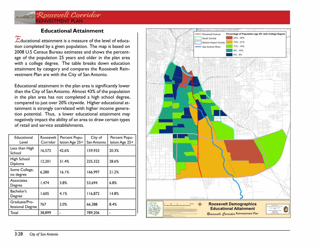
Educational Attainment
Educational attainment is a measure of the level of educa-tion completed by a given population. the map is based on 2008 U.s Census Bureau estimates and shows the percent-age of the population 25 years and older in the plan area with a college degree. the table breaks down education attainment by category and compares the Roosevelt Rein-vestment Plan are with the City of san antonio.
Educational attainment in the plan area is significantly lower than the City of san antonio. almost 43% of the population in the plan area has not completed a high school degree, compared to just over 20% citywide. Higher educational at-tainment is strongly correlated with higher income genera-tion potential. thus, a lower educational attainment may negatively impact the ability of an area to draw certain types of retail and service establishments.
Educational Level
Roosevelt Corridor
Percent Popu-lation age 25+
City of san antonio
Percent Popu-lation age 25+
Less than High school 16,572 42.6% 159,933 20.3%
High school diploma 12,201 31.4% 225,322 28.6%
some College, no degree 6,280 16.1% 166,997 21.2%
associates degree 1,474 3.8% 53,694 6.8%
Bachelor’s degree 1,605 4.1% 116,872 14.8%
graduate/Pro-fessional degree
767 2.0% 66,388 8.4%
total 38,899 - 789,206 -
City of San Antonio 3:29
REinVEstMEnt PLanRoosevelt CorridorREinVEstMEnt PLan
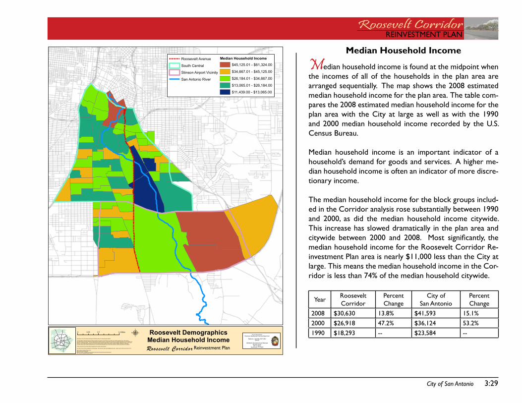
Median Household Income
Median household income is found at the midpoint when the incomes of all of the households in the plan area are arranged sequentially. the map shows the 2008 estimated median household income for the plan area. the table com-pares the 2008 estimated median household income for the plan area with the City at large as well as with the 1990 and 2000 median household income recorded by the U.s. Census Bureau.
Median household income is an important indicator of a household’s demand for goods and services. a higher me-dian household income is often an indicator of more discre-tionary income.
the median household income for the block groups includ-ed in the Corridor analysis rose substantially between 1990 and 2000, as did the median household income citywide. this increase has slowed dramatically in the plan area and citywide between 2000 and 2008. Most significantly, the median household income for the Roosevelt Corridor Re-investment Plan area is nearly $11,000 less than the City at large. this means the median household income in the Cor-ridor is less than 74% of the median household citywide.
year Roosevelt Corridor
Percent Change
City of san antonio
Percent Change
2008 $30,630 13.8% $41,593 15.1% 2000 $26,918 47.2% $36,124 53.2%1990 $18,293 -- $23,584 --
¦̈
µData Source: City of San Antonio Enterprise GIS, Bexar Metro 911, Bexar Appraisal District
"This Geographic Information System Product received from the City of San Antonio is provided "as is" without warranty of any kind, and theCity of San Antonio expressly disclaims all expressed and implied warranties, including but not limited to the implied warranties of merchantability andfitness for a particular purpose. The City of San Antonio does not warrant, guarantee, or make any representations regarding the use, or the resultsof the use, of the information provided to you by the City of San Antonio in terms of correctness, accuracy, reliability, timeliness or otherwise.The entire risk as to the results and performance of any information obtained from the City of San Antonio is entirely assumed by the recipient."
"Please contact the City of San Antonio Department for specific determinations."
City of San Antonio Planning Department GIS Manager: Dale Woodruff, [email protected]. Maps may be ordered at (210) 207-7873.
Map Created by: Michael Taylor, AICPMap Creation Date: May 2009Map File Location: K:\Neighborhoods\OVERLAY DISTRICTS\Studies\Roosevelt MetropolitanPDF Filename: NeighborhoodAssociations
Roosevelt Corridor
Roosevelt DemographicsMedian Household Income
0 0.7 1.40.35 MilesCity of SanAntonio
Planning & Development Services Department
Roderick J. Sanchez, AICP, CBODirector
Cliff Morton Development and BuisinessServices Center1901 S. Alamo
SanAntonio, TX 78204
Roosevelt Avenue
South Central
Stinson Airport Vicinity
San Antonio River
Median Household Income
$45,125.01 - $61,324.00
$34,667.01 - $45,125.00
$26,184.01 - $34,667.00
$13,065.01 - $26,184.00
$11,439.00 - $13,065.00
Reinvestment Plan
3:30 City of San Antonio
Roosevelt CorridorREinVEstMEnt PLan
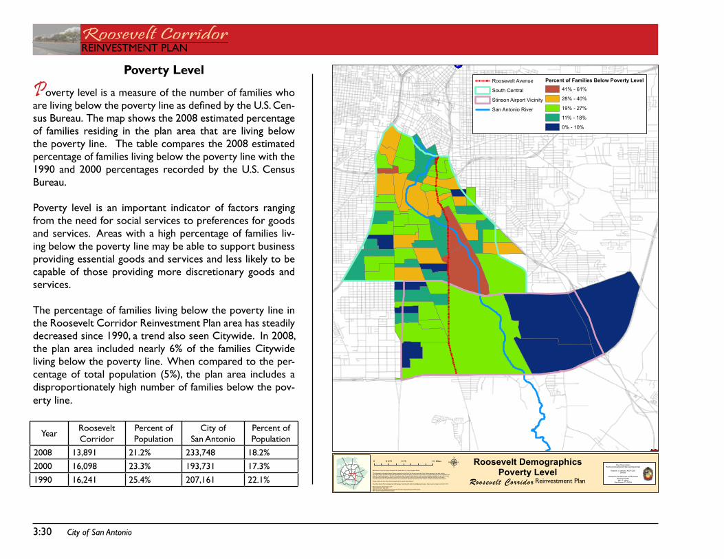
Poverty Level
Poverty level is a measure of the number of families who are living below the poverty line as defined by the U.S. Cen-sus Bureau. the map shows the 2008 estimated percentage of families residing in the plan area that are living below the poverty line. the table compares the 2008 estimated percentage of families living below the poverty line with the 1990 and 2000 percentages recorded by the U.s. Census Bureau.
Poverty level is an important indicator of factors ranging from the need for social services to preferences for goods and services. areas with a high percentage of families liv-ing below the poverty line may be able to support business providing essential goods and services and less likely to be capable of those providing more discretionary goods and services.
the percentage of families living below the poverty line in the Roosevelt Corridor Reinvestment Plan area has steadily decreased since 1990, a trend also seen Citywide. in 2008, the plan area included nearly 6% of the families Citywide living below the poverty line. When compared to the per-centage of total population (5%), the plan area includes a disproportionately high number of families below the pov-erty line.
year Roosevelt Corridor
Percent of Population
City of san antonio
Percent of Population
2008 13,891 21.2% 233,748 18.2%2000 16,098 23.3% 193,731 17.3%1990 16,241 25.4% 207,161 22.1%
37§̈¦37§̈¦37§̈¦37
§̈¦37
µData Source: City of San Antonio Enterprise GIS, Bexar Metro 911, Bexar Appraisal District
"This Geographic Information System Product received from the City of San Antonio is provided "as is" without warranty of any kind, and theCity of San Antonio expressly disclaims all expressed and implied warranties, including but not limited to the implied warranties of merchantability andfitness for a particular purpose. The City of San Antonio does not warrant, guarantee, or make any representations regarding the use, or the resultsof the use, of the information provided to you by the City of San Antonio in terms of correctness, accuracy, reliability, timeliness or otherwise.The entire risk as to the results and performance of any information obtained from the City of San Antonio is entirely assumed by the recipient."
"Please contact the City of San Antonio Department for specific determinations."
City of San Antonio Planning Department GIS Manager: Dale Woodruff, [email protected]. Maps may be ordered at (210) 207-7873.
Map Created by: Michael Taylor, AICPMap Creation Date: May 2009Map File Location: K:\Neighborhoods\OVERLAY DISTRICTS\Studies\Roosevelt MetropolitanPDF Filename: NeighborhoodAssociations
Roosevelt Corridor
Roosevelt DemographicsPoverty Level
0 0.75 1.50.375 MilesCity of SanAntonio
Planning & Development Services Department
Roderick J. Sanchez, AICP, CBODirector
Cliff Morton Development and BuisinessServices Center1901 S. Alamo
SanAntonio, TX 78204
Roosevelt Avenue
South Central
Stinson Airport Vicinity
San Antonio River
Percent of Families Below Poverty Level
41% - 61%
28% - 40%
19% - 27%
11% - 18%
0% - 10%
Reinvestment Plan
City of San Antonio 3:31
REinVEstMEnt PLanRoosevelt CorridorREinVEstMEnt PLan
PRESA
STS
FLOR
ESST
S
RO
OS
EV
ELT
AV
PLE
AS
AN
TON
RD
STEVES AV
CO
MM
ER
CIA
LAV
FAIR AV
GE
VE
RS
ST
S
MISSIO
NR
D
GOLIAD
RDC
LAR
KAV
RIGSBY AV
NE
WB
RA
UN
FELS
AVS
WA
LTE
RS
ST
S
HA
CK
BE
RR
YS
TS
ASHLEY RD
MILITARY DR SE
GILLETTE BV
HOT WELLS BV
MALONE ST W
SOUTHCROSS W
HUTCHINS PLACE
MO
UR
SU
ND
BV
THEO AV E
SOUTHCROSS BV E
THEO AV W
MILITARY DR SW/LOOP 13
DIVISION AV
NEW BRAUNFEL S
PR
OB
AN
DT
ST
BR
AZO
SS
TS
FRIOCITY RD
HUTCHINS PLACE E
PECANVALLE
Y DR
SE MILITARY DR/LOOP 13
NOGALIT
OSST
ST
MA
RY
SS
TS
SOUTHCROSS E
MILITARY DR SW
OLI
VE
ST
S
SOUTHCROSS BV E
NOGALIT
OSST
THEO AV W
CO
MM
ER
CIA
LAV
PRO
BAN
DT
ST
MO
UR
SU
ND
BV
MISSIONRD
DIVISION AV
MISSIONRD
OLI
VE
ST
S
§̈¦410
§̈¦10
§̈¦35
§̈¦37
£¤90
Highland Hills
Hot Wells
Highland Park
Kingsborough Ridge
Riverside South
Mission San Jose
Palm Heights
Gillette Area
Roosevelt Park Sunny Slope
Riverside
Collins Garden
East Pyron - Symphony Lane/ Mission San Jose
Denver HeightsLavaca
Tierra Linda
Artesia Community Guild
McCreless Meadows
µData Source: City of San Antonio EnterpriseGIS, Bexar Metro 911, Bexar Appraisal District
"This Geographic InformationSystem Product receivedfrom the City of SanAntonio is provided "as is" without warranty of any kind, and theCity of San Antonio expressly d isclaims all expressed and impl ied warranties, includingbut not limited to the impliedwarranties of merchantabili ty andfitness for a particular purpose. The Ci ty of SanAntoniodoes not warrant, guarantee, or makeany representations regarding the use, or the resul tsof theuse, of the information provided toyouby theCity of San Antonio in terms of correctness, accuracy, rel iabi lity, timeliness or otherwise.The entire risk as tothe results andperformance of any information obtained from theCi ty of San Antonio is enti re ly assumed by therecipient."
"Please contact the Ci ty of SanAntonioDepartment for speci fic determinations."
City of San Antonio Planning Department GIS Manager: Dale Woodruff, [email protected]. Maps may be orderedat (210) 207-7873.
Map Created by: Michael Taylor,AICPMap CreationDate: May 2009Map File Location: K:\Neighborhoods\OVERLAY DISTRICTS\Studies\Roosevel t MetropolitanPDF Filename: NeighborhoodAssociations
Roosevelt Corridor
Neighborhood Associations0 0.5 10.25 MilesCity of San Antonio
Planning & Development Services Department
Roderick J. Sanchez, AICP, CBODirector
Cliff Morton Development and Buis inessServices Center1901 S. Alamo
San Antonio, TX 78204
Roosevelt Avenue
Proposed Corridor Overlay District
San Antonio River
Reinvestment Plan
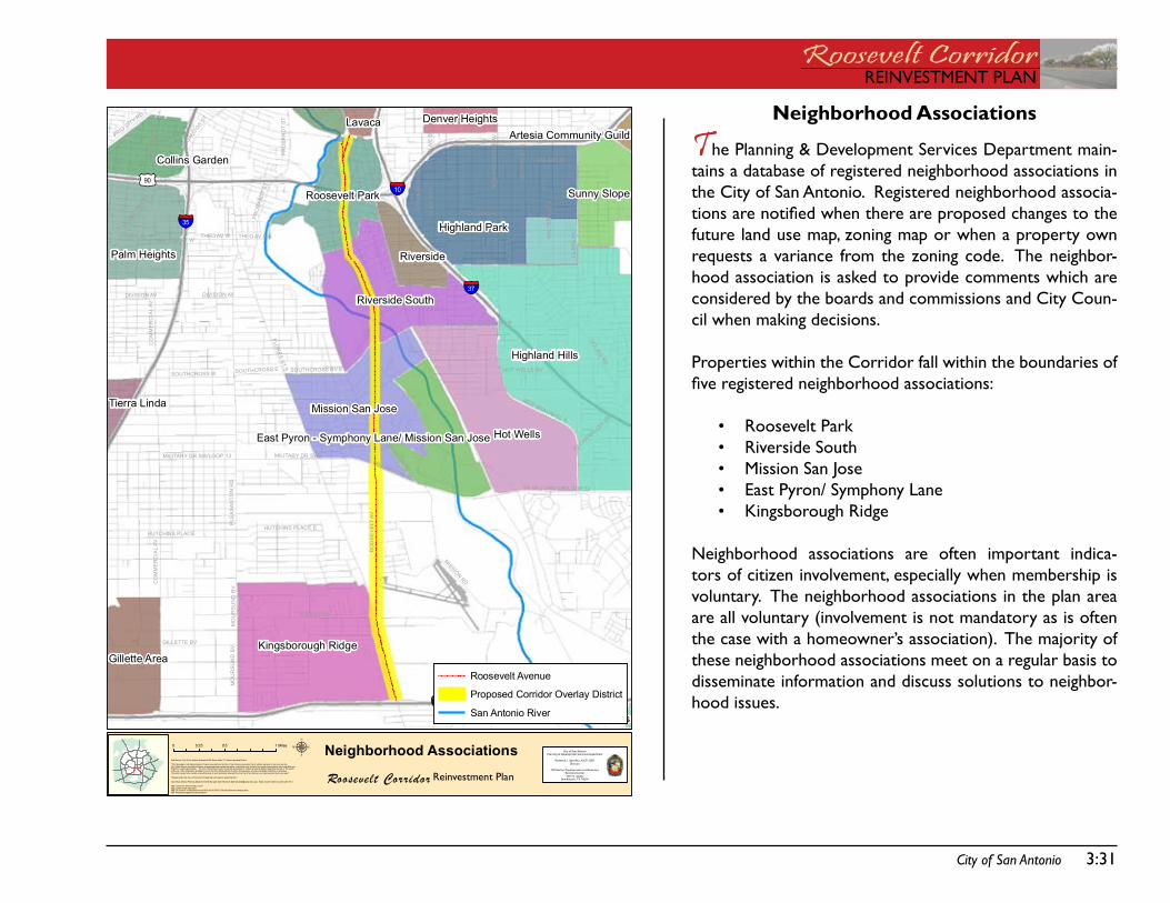
Neighborhood Associations
The Planning & development services department main-tains a database of registered neighborhood associations in the City of san antonio. Registered neighborhood associa-tions are notified when there are proposed changes to the future land use map, zoning map or when a property own requests a variance from the zoning code. the neighbor-hood association is asked to provide comments which are considered by the boards and commissions and City Coun-cil when making decisions.
Properties within the Corridor fall within the boundaries of five registered neighborhood associations:
Roosevelt ParkRiverside southMission san JoseEast Pyron/ symphony LaneKingsborough Ridge
neighborhood associations are often important indica-tors of citizen involvement, especially when membership is voluntary. the neighborhood associations in the plan area are all voluntary (involvement is not mandatory as is often the case with a homeowner’s association). the majority of these neighborhood associations meet on a regular basis to disseminate information and discuss solutions to neighbor-hood issues.
•••••
3:32 City of San Antonio
Roosevelt CorridorREinVEstMEnt PLan
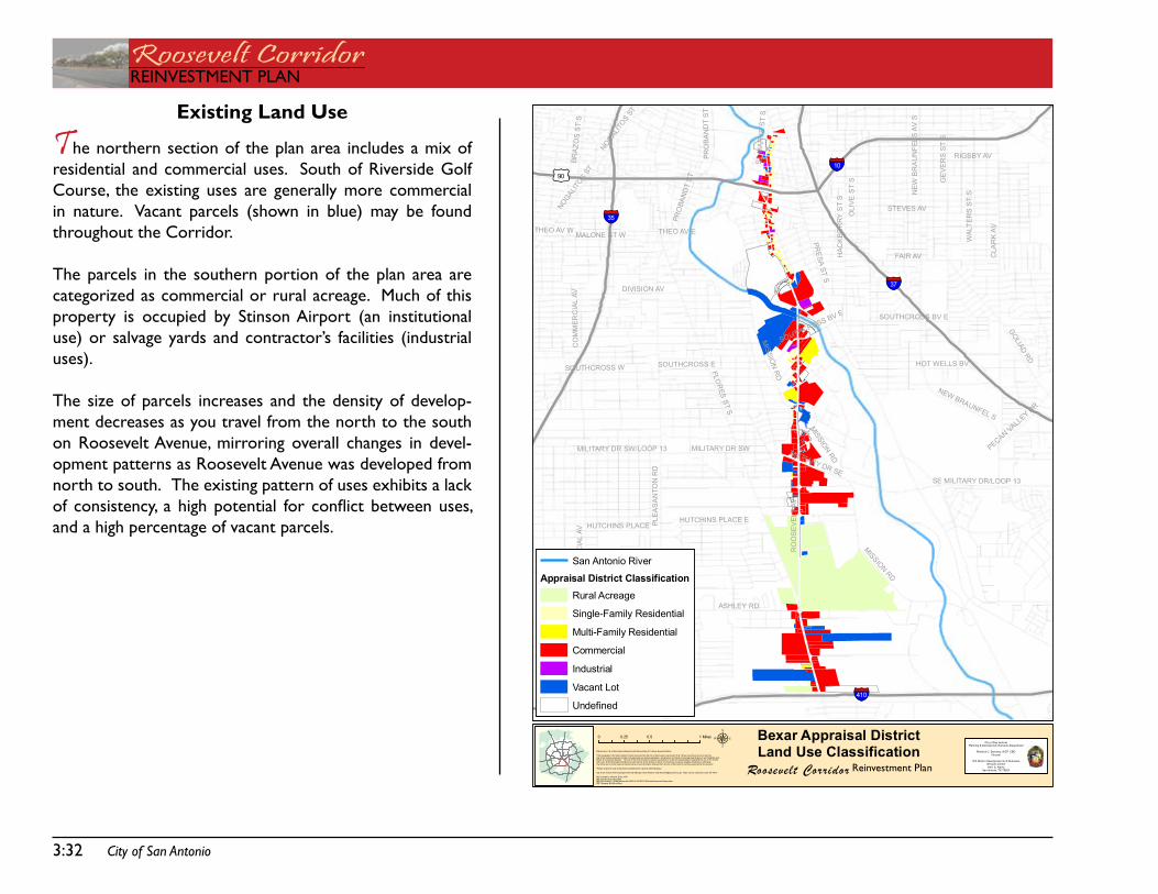
Existing Land Use
The northern section of the plan area includes a mix of residential and commercial uses. south of Riverside golf Course, the existing uses are generally more commercial in nature. Vacant parcels (shown in blue) may be found throughout the Corridor.
the parcels in the southern portion of the plan area are categorized as commercial or rural acreage. Much of this property is occupied by stinson airport (an institutional use) or salvage yards and contractor’s facilities (industrial uses).
the size of parcels increases and the density of develop-ment decreases as you travel from the north to the south on Roosevelt avenue, mirroring overall changes in devel-opment patterns as Roosevelt avenue was developed from north to south. the existing pattern of uses exhibits a lack of consistency, a high potential for conflict between uses, and a high percentage of vacant parcels.
PRESA
STS
FLOR
ESST
S
RO
OS
EVE
LTAV
PLEA
SA
NTO
NR
D
STEVES AV
CO
MM
ERC
IAL
AV
FAIR AV
GE
VER
SS
TS
MISSIO
NR
D
GOLIADRD
CLA
RK
AV
RIGSBY AV
NEW
BR
AU
NFE
LSAV
S
WAL
TER
SS
TS
HAC
KB
ER
RY
ST
S
ASHLEY RD
MILITARY DR SE
GILLETTE BV
HOT WELLS BV
MALONE ST W
SOUTHCROSS W
HUTCHINS PLACE
MO
UR
SU
ND
BV
THEO AV E
SOUTHCROSS BV E
THEO AV W
MILITARY DR SW/LOOP 13
DIVISION AV
NEW BRAUNFEL S
PRO
BAN
DT
ST
BRA
ZOS
ST
S
HUTCHINS PLACE E
PECANVALL
EY DR
SE MILITARY DR/LOOP 13
NOGALIT
OSST
STM
AR
YS
ST
S
SOUTHCROSS E
MILITARY DR SW
OLI
VE
ST
S
SOUTHCROSS BV E
NOGALIT
OSST
CO
MM
ERC
IAL
AV
PRO
BAN
DT
ST
MISSIONRD
MISSION
RD
§̈¦410
§̈¦10
§̈¦35
§̈¦37
£¤90
µData Source: City of San Antonio EnterpriseGIS, Bexar Metro 911, Bexar Appraisal District
"This Geographic InformationSystem Product receivedfrom the City of SanAntonio is provided "as is" without warranty of any kind, and theCity of San Antonio expressly d isclaims all expressed and impl ied warranties, includingbut not limited to the impliedwarranties of merchantabili ty andfitness for a particular purpose. The Ci ty of SanAntoniodoes not warrant, guarantee, or makeany representations regarding the use, or the resul tsof theuse, of the information provided toyouby theCity of San Antonio in terms of correctness, accuracy, rel iabi lity, timeliness or otherwise.The entire risk as tothe results andperformance of any information obtained from theCi ty of San Antonio is enti re ly assumed by therecipient."
"Please contact the Ci ty of SanAntonioDepartment for speci fic determinations."
City of San Antonio Planning Department GIS Manager: Dale Woodruff, [email protected]. Maps may be orderedat (210) 207-7873.
Map Created by: Michael Taylor,AICPMap CreationDate: May 2009Map File Location: K:\Neighborhoods\OVERLAY DISTRICTS\Studies\Roosevel t MetropolitanPDF Filename: BCADLandUse
0 0.5 10.25 MilesCity of San Antonio
Planning & Development Services Department
Roderick J. Sanchez, AICP, CBODirector
Cliff Morton Development and Buis inessServices Center1901 S. Alamo
San Antonio, TX 78204
San Antonio River
Appraisal District ClassificationRural Acreage
Single-Family Residential
Multi-Family Residential
Commercial
Industrial
Vacant Lot
Undefined
Roosevelt Corridor
Bexar Appraisal DistrictLand Use Classification
Reinvestment Plan
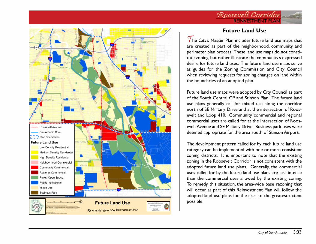
City of San Antonio 3:33
REinVEstMEnt PLanRoosevelt CorridorREinVEstMEnt PLan
Future Land Use
The City’s Master Plan includes future land use maps that are created as part of the neighborhood, community and perimeter plan process. these land use maps do not consti-tute zoning, but rather illustrate the community’s expressed desire for future land uses. the future land use maps serve as guides for the Zoning Commission and City Council when reviewing requests for zoning changes on land within the boundaries of an adopted plan.
future land use maps were adopted by City Council as part of the south Central CP and stinson Plan. the future land use plans generally call for mixed use along the corridor north of sE Military drive and at the intersection of Roos-evelt and Loop 410. Community commercial and regional commercial uses are called for at the intersection of Roos-evelt avenue and sE Military drive. Business park uses were deemed appropriate for the area south of stinson airport.
the development pattern called for by each future land use category can be implemented with one or more consistent zoning districts. it is important to note that the existing zoning in the Roosevelt Corridor is not consistent with the adopted future land use plans. generally, the commercial uses called for by the future land use plans are less intense than the commercial uses allowed by the existing zoning. to remedy this situation, the area-wide base rezoning that will occur as part of this Reinvestment Plan will follow the adopted land use plans for the area to the greatest extent possible.
PRESA
STS
FLOR
ESST
S
RO
OS
EVE
LTAV
PLEA
SA
NTO
NR
D
STEVES AV
CO
MM
ERC
IAL
AV
FAIR AV
GE
VER
SS
TS
MISSIO
NR
D
GOLIADRD
CLA
RK
AV
RIGSBY AV
NEW
BR
AU
NFE
LSAV
S
WAL
TER
SS
TS
HAC
KB
ER
RY
ST
S
ASHLEY RD
MILITARY DR SE
GILLETTE BV
HOT WELLS BV
MALONE ST W
SOUTHCROSS W
HUTCHINS PLACE
MO
UR
SU
ND
BV
THEO AV E
SOUTHCROSS BV E
THEO AV W
MILITARY DR SW/LOOP 13
DIVISION AV
NEW BRAUNFEL S
PRO
BAN
DT
ST
BRA
ZOS
ST
S
HUTCHINS PLACE E
PECANVALL
EY DR
SE MILITARY DR/LOOP 13
NOGALIT
OSST
STM
AR
YS
ST
S
SOUTHCROSS E
MILITARY DR SW
OLI
VE
ST
S
SOUTHCROSS BV E
NOGALIT
OSST
CO
MM
ERC
IAL
AV
PRO
BAN
DT
ST
MISSIONRD
MISSION
RD
§̈¦410
§̈¦10
§̈¦35
§̈¦37
£¤90
µData Source: City of San Antonio EnterpriseGIS, Bexar Metro 911, Bexar Appraisal District
"This Geographic InformationSystem Product receivedfrom the City of SanAntonio is provided "as is" without warranty of any kind, and theCity of San Antonio expressly d isclaims all expressed and impl ied warranties, includingbut not limited to the impliedwarranties of merchantabili ty andfitness for a particular purpose. The Ci ty of SanAntoniodoes not warrant, guarantee, or makeany representations regarding the use, or the resul tsof theuse, of the information provided toyouby theCity of San Antonio in terms of correctness, accuracy, rel iabi lity, timeliness or otherwise.The entire risk as tothe results andperformance of any information obtained from theCi ty of San Antonio is enti re ly assumed by therecipient."
"Please contact the Ci ty of SanAntonioDepartment for speci fic determinations."
City of San Antonio Planning Department GIS Manager: Dale Woodruff, [email protected]. Maps may be orderedat (210) 207-7873.
Map Created by: Michael Taylor,AICPMap CreationDate: May 2009Map File Location: K:\Neighborhoods\OVERLAY DISTRICTS\Studies\Roosevel t MetropolitanPDF Filename: FutureLandUse
0 0.5 10.25 MilesCity of San Antonio
Planning & Development Services Department
Roderick J. Sanchez, AICP, CBODirector
Cliff Morton Development and Buis inessServices Center1901 S. Alamo
San Antonio, TX 78204
Roosevelt Avenue
San Antonio River
Plan Boundaries
Future Land UseLow Density Residential
Medium Density Residential
High Density Residential
Neighborhood Commercial
Community Commercial
Regional Commercial
Parks/ Open Space
Public Institutional
Mixed Use
Business Park
Roosevelt Corridor
Future Land UseReinvestment Plan
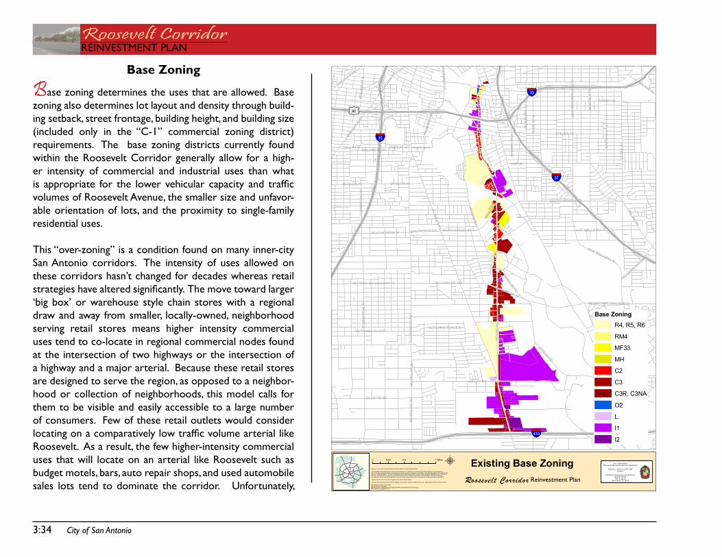
3:34 City of San Antonio
Roosevelt CorridorREinVEstMEnt PLan
PRESA ST S
FLOR
ESST
S
RO
OS
EV
ELT
AV
PLE
AS
AN
TON
RD
STEVES AV
CO
MM
ER
CIA
LAV
FAIR AV
GE
VE
RS
ST
S
MISSIO
NR
D
GOLIAD
RD
CLA
RK
AV
RIGSBY AV
NE
WB
RA
UN
FELS
AVS
WA
LTE
RS
ST
S
HA
CK
BE
RR
YS
TS
ASHLEY RD
MILITARY DR SE
GILLETTE BV
HOT WELLS BV
MALONE ST W
SOUTHCROSS W
HUTCHINS PLACE
MO
UR
SU
ND
BV
THEO AV E
SOUTHCROSS BV E
THEO AV W
MILITARY DR SW/LOOP 13
DIVISION AV
NEW BRAUNFEL S
PR
OB
AN
DT
ST
BR
AZO
SS
TS
FRIOCITY RD
HUTCHINS PLACE E
PECANVALLE
Y DR
SE MILITARY DR/LOOP 13
NOGALIT
OSST
SOUTHCROSS E
ROLAND AV
MILITARY DR SW
CH
ER
RY
ST
S
OLI
VE
ST
S
SOUTHCROSS BV E
NOGALIT
OSST
THEO AV W
CO
MM
ER
CIA
LAV
PRO
BAN
DT
ST
MO
UR
SU
ND
BV
MISSIONRD
DIVISION AV
MISSIONRD
§̈¦410
§̈¦10
§̈¦35
§̈¦37
£¤90
µData Source: City of San Antonio EnterpriseGIS, Bexar Metro 911, Bexar Appraisal District
"This Geographic InformationSystem Product receivedfrom the City of SanAntonio is provided "as is" without warranty of any kind, and theCity of San Antonio expressly d isclaims all expressed and impl ied warranties, includingbut not limited to the impliedwarranties of merchantabili ty andfitness for a particular purpose. The Ci ty of SanAntoniodoes not warrant, guarantee, or makeany representations regarding the use, or the resul tsof theuse, of the information provided toyouby theCity of San Antonio in terms of correctness, accuracy, rel iabi lity, timeliness or otherwise.The entire risk as tothe results andperformance of any information obtained from theCi ty of San Antonio is entire ly assumed by therecip ient."
"Please contact the Ci ty of SanAntonioDepartment for speci fic determinations."
City of San Antonio Planning Department GIS Manager: Dale Woodruff, [email protected]. Maps may be orderedat (210) 207-7873.
Map Created by: Michael Taylor,AICPMap CreationDate: May 2009Map File Location: K:\Neighborhoods\OVERLAY DISTRICTS\Studies\Roosevel t MetropolitanPDF Filename: ExistingBaseZoning
0 0.5 10.25 MilesCity of San Antonio
Planning & Development Services Department
Roderick J. Sanchez, AICP, CBODirector
Cliff Morton Development and Buis inessServices Center1901 S. Alamo
San Antonio, TX 78204
Base ZoningR4, R5, R6
RM4
MF33
MH
C2
C3
C3R, C3NA
O2
L
I1
I2
Roosevelt Corridor
Existing Base ZoningReinvestment Plan
Base Zoning
Base zoning determines the uses that are allowed. Base zoning also determines lot layout and density through build-ing setback, street frontage, building height, and building size (included only in the “C-1” commercial zoning district) requirements. the base zoning districts currently found within the Roosevelt Corridor generally allow for a high-er intensity of commercial and industrial uses than what is appropriate for the lower vehicular capacity and traffic volumes of Roosevelt avenue, the smaller size and unfavor-able orientation of lots, and the proximity to single-family residential uses.
this “over-zoning” is a condition found on many inner-city san antonio corridors. the intensity of uses allowed on these corridors hasn’t changed for decades whereas retail strategies have altered significantly. The move toward larger ‘big box’ or warehouse style chain stores with a regional draw and away from smaller, locally-owned, neighborhood serving retail stores means higher intensity commercial uses tend to co-locate in regional commercial nodes found at the intersection of two highways or the intersection of a highway and a major arterial. Because these retail stores are designed to serve the region, as opposed to a neighbor-hood or collection of neighborhoods, this model calls for them to be visible and easily accessible to a large number of consumers. few of these retail outlets would consider locating on a comparatively low traffic volume arterial like Roosevelt. as a result, the few higher-intensity commercial uses that will locate on an arterial like Roosevelt such as budget motels, bars, auto repair shops, and used automobile sales lots tend to dominate the corridor. Unfortunately,
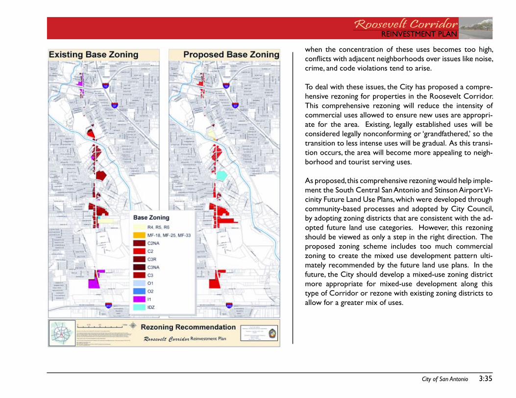
City of San Antonio 3:35
REinVEstMEnt PLanRoosevelt CorridorREinVEstMEnt PLan
when the concentration of these uses becomes too high, conflicts with adjacent neighborhoods over issues like noise, crime, and code violations tend to arise.
to deal with these issues, the City has proposed a compre-hensive rezoning for properties in the Roosevelt Corridor. this comprehensive rezoning will reduce the intensity of commercial uses allowed to ensure new uses are appropri-ate for the area. Existing, legally established uses will be considered legally nonconforming or ‘grandfathered,’ so the transition to less intense uses will be gradual. as this transi-tion occurs, the area will become more appealing to neigh-borhood and tourist serving uses.
as proposed, this comprehensive rezoning would help imple-ment the south Central san antonio and stinson airport Vi-cinity future Land Use Plans, which were developed through community-based processes and adopted by City Council, by adopting zoning districts that are consistent with the ad-opted future land use categories. However, this rezoning should be viewed as only a step in the right direction. the proposed zoning scheme includes too much commercial zoning to create the mixed use development pattern ulti-mately recommended by the future land use plans. in the future, the City should develop a mixed-use zoning district more appropriate for mixed-use development along this type of Corridor or rezone with existing zoning districts to allow for a greater mix of uses.
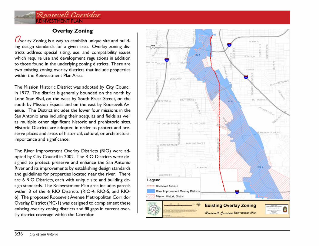
3:36 City of San Antonio
Roosevelt CorridorREinVEstMEnt PLan
PRESA
STS
RO
OS
EVE
LTAV
FLOR
ESST
S
PLEA
SA
NTO
NR
D
STEVES AV
CO
MM
ERC
IAL
AV
RIGSBY AV
FAIR AV
GE
VER
SS
TS
MISSIO
NR
D
GOLIADRD
CLA
RK
AV
NEW
BR
AU
NFE
LSAV
S
WAL
TER
SS
TS
ASHLEY RD
HAC
KB
ER
RY
ST
S
MILITARY DR SE
HOT WELLS BV
GILLETTE BV
MALONE ST W THEO AV E
MO
UR
SU
ND
BV
HUTCHINS PLACE
SOUTHCROSS BV E
SOUTHCROSS W
THEO AV W
MILITARY DR SW/LOOP 13
DIVISION AV
NEW BRAUNFEL S
PRO
BAN
DT
ST
BRA
ZOS
ST
S
HUTCHINS PLACE E
SE MILITARY DR/LOOP 13
PECANVALL
EY DR
NOGALIT
OSST
SOUTHCROSS E
MILITARY DR SW
OLI
VE
ST
S
SOUTHCROSS BV E
CO
MM
ERC
IAL
AV
PRO
BAN
DT
ST
MISSIONRD
MISSION
RD
§̈¦410
§̈¦10
§̈¦35
§̈¦37
£¤90
RIO-6
RIO-5
RIO-4
µData Source: City of San Antonio EnterpriseGIS, Bexar Metro 911, Bexar Appraisal District
"This Geographic InformationSystem Product receivedfrom the City of SanAntonio is provided "as is" without warranty of any kind, and theCity of San Antonio expressly d isclaims all expressed and impl ied warranties, includingbut not limited to the impliedwarranties of merchantabili ty andfitness for a particular purpose. The Ci ty of SanAntoniodoes not warrant, guarantee, or makeany representations regarding the use, or the resul tsof theuse, of the information provided toyouby theCity of San Antonio in terms of correctness, accuracy, rel iabi lity, timeliness or otherwise.The entire risk as tothe results andperformance of any information obtained from theCi ty of San Antonio is entire ly assumed by therecip ient."
"Please contact the Ci ty of SanAntonioDepartment for speci fic determinations."
City of San Antonio Planning Department GIS Manager: Dale Woodruff, [email protected]. Maps may be orderedat (210) 207-7873.
Map Created by: Michael Taylor,AICPMap CreationDate: May 2009Map File Location: K:\Neighborhoods\OVERLAY DISTRICTS\Studies\Roosevel t MetropolitanPDF Filename: ExistingOverlayZoning
0 0.5 10.25 MilesCity of San Antonio
Planning & Development Services Department
Roderick J. Sanchez, AICP, CBODirector
Cliff Morton Development and Buis inessServices Center1901 S. Alamo
San Antonio, TX 78204
LegendRoosevelt Avenue
River Improvement Overlay Districts
Mission Historic District
Roosevelt Corridor
Existing Overlay ZoningReinvestment Plan
Overlay Zoning
Overlay Zoning is a way to establish unique site and build-ing design standards for a given area. overlay zoning dis-tricts address special siting, use, and compatibility issues which require use and development regulations in addition to those found in the underlying zoning districts. there are two existing zoning overlay districts that include properties within the Reinvestment Plan area.
the Mission Historic district was adopted by City Council in 1977. the district is generally bounded on the north by Lone star Blvd, on the west by south Presa street, on the south by Mission Espada, and on the east by Roosevelt av-enue. the district includes the lower four missions in the San Antonio area including their acequias and fields as well as multiple other significant historic and prehistoric sites. Historic districts are adopted in order to protect and pre-serve places and areas of historical, cultural, or architectural importance and significance.
the River improvement overlay districts (Rio) were ad-opted by City Council in 2002. the Rio districts were de-signed to protect, preserve and enhance the san antonio River and its improvements by establishing design standards and guidelines for properties located near the river. there are 6 Rio districts, each with unique site and building de-sign standards. the Reinvestment Plan area includes parcels within 3 of the 6 Rio districts (Rio-4, Rio-5, and Rio-6). the proposed Roosevelt avenue Metropolitan Corridor overlay district (MC-1) was designed to complement these existing overlay zoning districts and fill gaps in current over-lay district coverage within the Corridor.
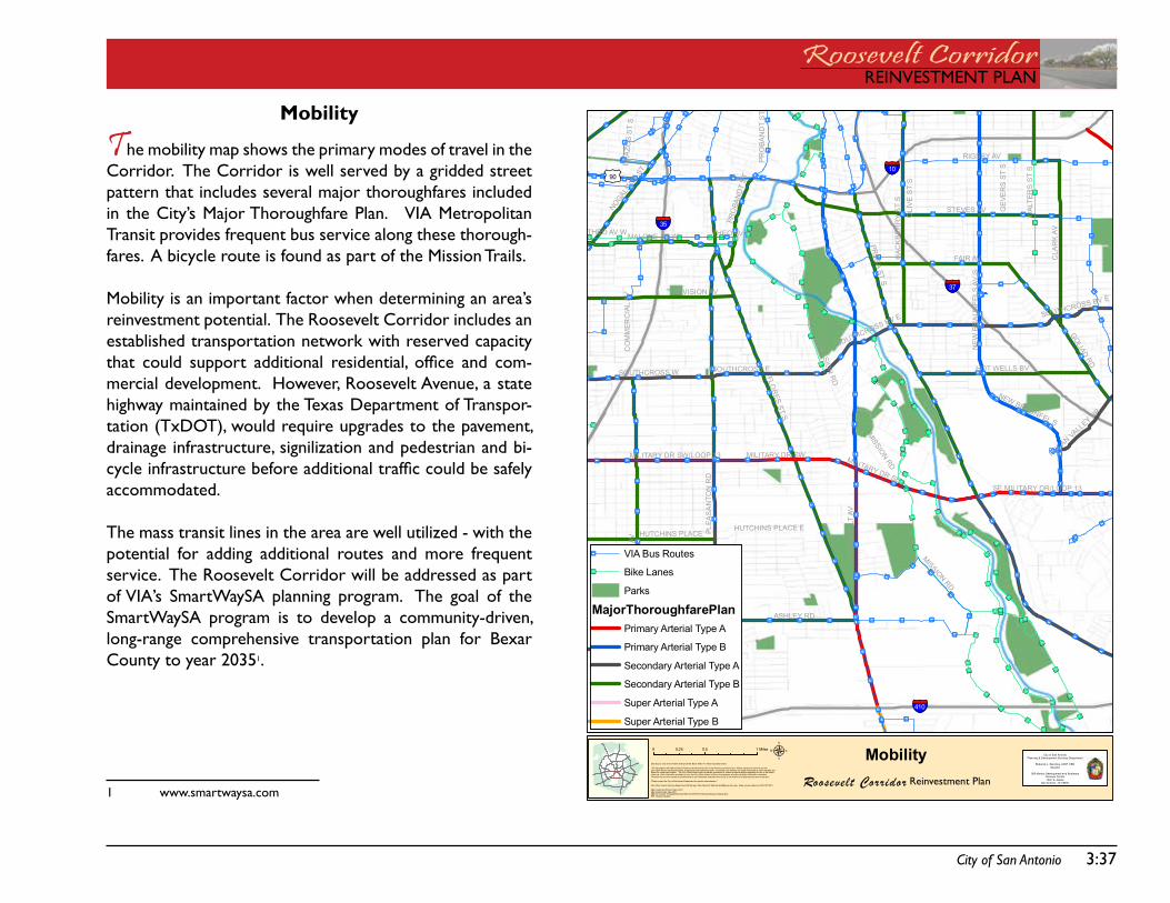
City of San Antonio 3:37
REinVEstMEnt PLanRoosevelt CorridorREinVEstMEnt PLan
¾ ¾½
¾¾½
¾¾½
¾¾½
¾¾½
¾¾½
¾¾½¾¾½¾¾½¾¾½¾¾½¾¾½¾¾½
¾¾½¾¾½¾¾½ ¾¾½
¾¾½
¾¾½¾¾½
¾¾½
¾¾½
¾¾½
¾¾½
¾¾½
¾¾½
¾¾½¾¾½
¾¾½
¾¾½
¾¾½
¾¾½
¾¾½
¾¾½ ¾¾½
¾¾½
¾¾½
¾¾½
¾¾½
¾¾½
¾¾½
¾¾½
¾¾½¾¾½
¾¾½
¾¾½
¾¾½
¾¾½
¾¾½
¾¾½¾¾½
¾¾½
¾¾½
¾¾½
¾¾½
¾¾½
¾¾½
¾¾½¾¾½
¾¾½
¾¾½
¾¾½
¾¾½
¾¾½
¾¾½
¾¾½
¾¾½
¾¾½
¾¾½
¾¾½
¾¾½
¾¾½
¾¾½
¾¾½
¾¾½
¾¾½
¾¾½¾¾½
¾¾½¾¾½
¾¾½
¾¾½
¾¾½
¾¾½
¾¾½
¾¾½
¾ ¾½¾ ¾½
¾ ¾½¾ ¾½
¾ ¾½¾ ¾½
¾ ¾½¾ ¾½
¾¾¿
¾¾¿
¾¾¿
¾¾¿¾¾¿
¾¾¿
¾¾¿¾¾¿¾¾¿
¾¾¿¾¾¿¾¾¿¾¾¿¾¾¿¾¾¿ ¾¾¿
¾¾¿¾¾¿
¾¾¿¾¾¿¾¾¿
¾¾¿
¾¾¿¾¾¿¾¾¿
¾¾¿¾¾¿
¾¾¿
¾¾¿¾¾¿
¾¾¿
¾¾¿ ¾¾¿ ¾¾¿ ¾¾¿¾¾¿
¾¾¿¾¾¿
¾¾¿¾¾¿
¾¾¿
¾¾¿
¾¾¿
¾¾¿
¾¾¿
¾¾¿
¾¾¿
¾¾¿¾¾¿ ¾¾¿
¾¾¿
¾¾¿
¾¾¿
¾¾¿
¾¾¿
¾¾¿¾¾¿¾¾¿¾¾¿
¾
¾¾¿
¾¾¿¾¾¿
¾¾¿
¾¾¿
¾ ¾¿¾ ¾¿
¾¾¿¾¾¿
¾¾¿¾¾¿
¾¾¿¾¾¿
¾¾¿¾¾¿
¾¾¿¾¾¿
¾¾¿
¾¾¿¾¾¿
¾¾¿¾¾¿
¾¾¿
¾¾¿¾¾¿
¾¾¿¾¾¿
¾¾¿
¾¾¿
¾¾¿
¾¾¿
¾¾¿
¾¾¿ ¾¾¿
¾¾¿
¾¾¿
¾¾¿¾¾¿
¾¾¿
¾¾¿
¾¾¿
¾¾¿
¾¾¿
¾¾¿
¾¾¿
¾¾¿¾¾¿¾¾¿¾¾¿
¾¾¿
¾¾¿
¾¾¿
¾¾¿
¾¾¿ ¾¾¿ ¾¾¿
¾¾¿
¾¾¿¾¾¿
¾¾¿
¾¾¿
¾¾¿
¾¾¿
¾¾¿
¾¾¿
¾¾¿
¾¾¿
¾¾¿
¾¾¿¾¾¿
¾¾¿
¾¾¿¾¾¿
¾¾¿¾¾¿
¾¾¿¾¾¿
¾¾¿¾¾¿
¾ ¾¿
¾¾¿
¾¾¿
¾¾¿¾ ¾¿
¾ ¾¿¾ ¾¿
¾¾¿ ¾¾¿ ¾¾¿ ¾¾¿ ¾¾¿ ¾¾¿
¾¾¿¾ ¾¿
¾¾¿¾¾¿
¾¾¿¾¾¿
¾¾¿¾¾¿ ¾¾¿
¾¾¿¾ ¾¿
¾¾¿ ¾¾¿ ¾¾¿ ¾¾¿ ¾¾¿ ¾¾¿ ¾¾¿
¾¾¿ ¾¾¿ ¾¾¿ ¾¾¿ ¾¾¿ ¾¾¿
¾¾¿
¾¾¿
¾¾¿
¾¾¿
¾¾¿
¾¾¿¾¾¿
¾¾¿¾¾¿ ¾¾¿
¾¾¿
¾¾¿¾¾¿
¾¾¿¾¾¿
¾¾¿
¾¾¿
¾¾¿
¾¾¿
¾¾¿
¾¾¿
¾¾¿
¾¾¿
¾¾¿
¾¾¿
¾¾¿
¾¾¿
¾¾¿
¾¾¿
¾¾¿¾¾¿¾¾¿¾¾¿¾¾¿
¾¾¿¾¾¿¾¾¿
¾¾¿¾¾¿
¾¾¿¾¾¿
¾¾¿¾¾¿
¾¾¿¾¾¿
¾¾¿¾¾¿
¾¾¿¾¾¿¾¾¿
¾¾¿¾¾¿
¾¾¿¾¾¿
¾¾¿¾¾¿¾¾¿¾¾¿¾¾¿¾¾¿
¾¾¿
¾¾¿
¾¾¿
¾¾¿¾¾¿¾¾¿¾¾¿¾¾¿¾¾¿¾¾¿¾¾¿¾¾¿
¾¾¿¾¾¿
¾¾¿¾¾¿
¾¾¿¾¾¿
¾¾¿
¾¾¿¾¾¿
¾¾¿¾¾¿
¾¾¿
¾¾¿
¾¾¿
¾¾¿¾¾¿
¾¾¿
¾¾¿ ¾¾¿ ¾¾¿ ¾¾¿ ¾¾¿¾¾¿ ¾¾¿ ¾¾¿ ¾¾¿
¾¾¿
¾¾¿
¾¾¿ ¾¾¿ ¾¾¿ ¾¾¿¾¾¿ ¾¾¿ ¾¾¿
¾¾¿
¾¾¿
¾¾¿¾¾¿¾¾¿
¾¾¿¾¾¿
¾¾¿
¾¾¿
¾ ¾¿
¾¾¿¾¾¿
¾¾¿¾¾¿
¾¾¿¾¾¿
¾¾¿¾¾¿
¾¾¿
¾¾¿¾¾¿
¾¾¿¾¾¿
¾¾¿
¾¾¿¾¾¿
¾¾¿
¾¾¿
¾¾¿
¾¾¿ ¾¾¿ ¾¾¿ ¾¾¿
¾¾¿
¾¾¿ ¾¾¿ ¾¾¿
PRESA
STS
RO
OS
EVE
LTAV
FLOR
ESST
S
PLEA
SA
NTO
NR
D
STEVES AV
CO
MM
ERC
IAL
AV
RIGSBY AV
FAIR AV
GE
VER
SS
TS
MISSIO
NR
D
GOLIADRD
CLA
RK
AV
NEW
BR
AU
NFE
LSAV
S
WAL
TER
SS
TS
ASHLEY RD
HAC
KB
ER
RY
ST
S
MILITARY DR SE
HOT WELLS BV
GILLETTE BV
MALONE ST W THEO AV E
MO
UR
SU
ND
BV
HUTCHINS PLACE
SOUTHCROSS BV E
SOUTHCROSS W
THEO AV W
MILITARY DR SW/LOOP 13
DIVISION AV
NEW BRAUNFEL S
PRO
BAN
DT
ST
BRA
ZOS
ST
S
HUTCHINS PLACE E
SE MILITARY DR/LOOP 13
PECANVALL
EY DR
NOGALIT
OSST
SOUTHCROSS E
MILITARY DR SW
OLI
VE
ST
S
SOUTHCROSS BV E
CO
MM
ERC
IAL
AV
PRO
BAN
DT
ST
MISSIONRD
MISSION
RD
§̈¦410
§̈¦10
§̈¦35
§̈¦37
£¤90
µData Source: City of San Antonio EnterpriseGIS, Bexar Metro 911, Bexar Appraisal District
"This Geographic InformationSystem Product receivedfrom the City of SanAntonio is provided "as is" without warranty of any kind, and theCity of San Antonio expressly d isclaims all expressed and impl ied warranties, includingbut not limited to the impliedwarranties of merchantabili ty andfitness for a particular purpose. The Ci ty of SanAntoniodoes not warrant, guarantee, or makeany representations regarding the use, or the resul tsof theuse, of the information provided toyouby theCity of San Antonio in terms of correctness, accuracy, rel iabi lity, timeliness or otherwise.The entire risk as tothe results andperformance of any information obtained from theCi ty of San Antonio is entire ly assumed by therecip ient."
"Please contact the Ci ty of SanAntonioDepartment for speci fic determinations."
City of San Antonio Planning Department GIS Manager: Dale Woodruff, [email protected]. Maps may be orderedat (210) 207-7873.
Map Created by: Michael Taylor,AICPMap CreationDate: May 2009Map File Location: K:\Neighborhoods\OVERLAY DISTRICTS\Studies\Roosevel t MetropolitanPDF Filename: Mobi lity
0 0.5 10.25 MilesCity of San Antonio
Planning & Development Services Department
Roderick J. Sanchez, AICP, CBODirector
Cliff Morton Development and Buis inessServices Center1901 S. Alamo
San Antonio, TX 78204
¾¾¿ VIA Bus Routes
¾¾½ Bike Lanes
Parks
MajorThoroughfarePlanPrimary Arterial Type A
Primary Arterial Type B
Secondary Arterial Type A
Secondary Arterial Type B
Super Arterial Type A
Super Arterial Type B
Roosevelt Corridor
MobilityReinvestment Plan
Mobility
The mobility map shows the primary modes of travel in the Corridor. the Corridor is well served by a gridded street pattern that includes several major thoroughfares included in the City’s Major thoroughfare Plan. Via Metropolitan transit provides frequent bus service along these thorough-fares. a bicycle route is found as part of the Mission trails. Mobility is an important factor when determining an area’s reinvestment potential. the Roosevelt Corridor includes an established transportation network with reserved capacity that could support additional residential, office and com-mercial development. However, Roosevelt avenue, a state highway maintained by the texas department of transpor-tation (txdot), would require upgrades to the pavement, drainage infrastructure, signilization and pedestrian and bi-cycle infrastructure before additional traffic could be safely accommodated.
the mass transit lines in the area are well utilized - with the potential for adding additional routes and more frequent service. the Roosevelt Corridor will be addressed as part of Via’s smartWaysa planning program. the goal of the smartWaysa program is to develop a community-driven, long-range comprehensive transportation plan for Bexar County to year 20351.
1 www.smartwaysa.com
Roosevelt CorridorREinVEstMEnt PLan
3:38 City of San Antonio
this page intentionally left blank.

REinVEstMEnt PLanRoosevelt CorridorREinVEstMEnt PLan
assEtsCHaPtER 4:

Roosevelt CorridorREinVEstMEnt PLan
this page intentionally left blank.
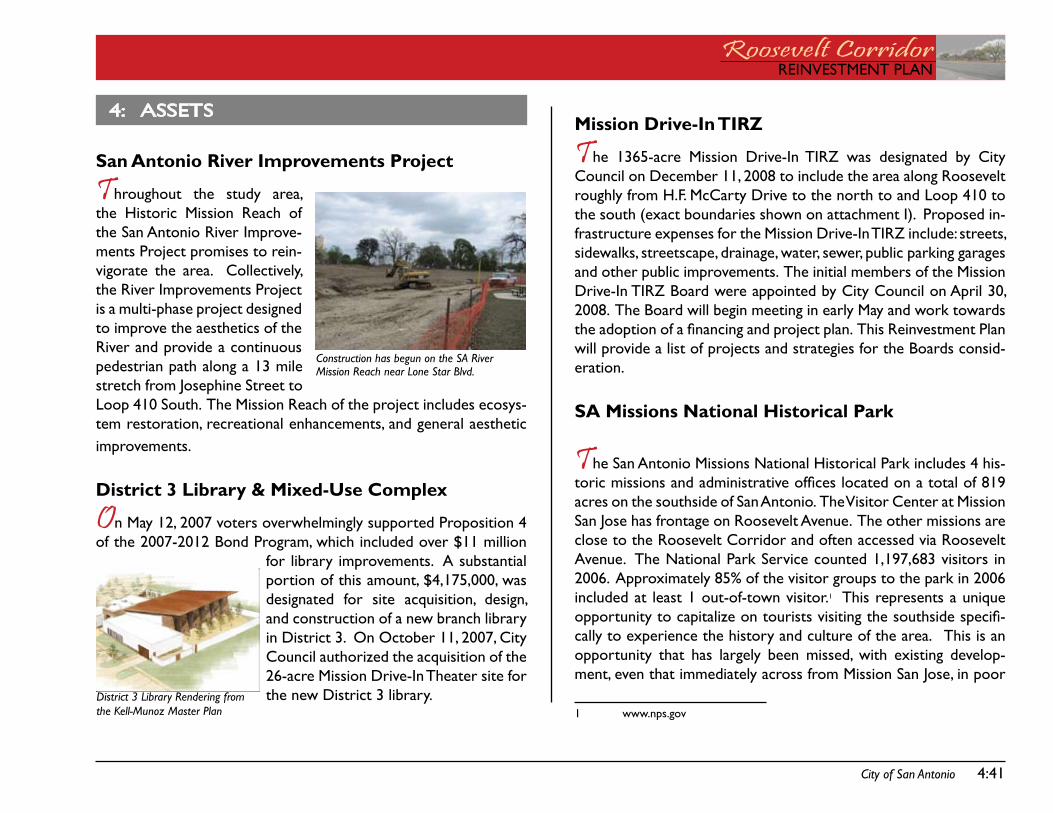
City of San Antonio 4:41
REinVEstMEnt PLanRoosevelt CorridorREinVEstMEnt PLan
Mission Drive-In TIRZ
The 1365-acre Mission drive-in tiRZ was designated by City Council on december 11, 2008 to include the area along Roosevelt roughly from H.f. McCarty drive to the north to and Loop 410 to the south (exact boundaries shown on attachment i). Proposed in-frastructure expenses for the Mission drive-in tiRZ include: streets, sidewalks, streetscape, drainage, water, sewer, public parking garages and other public improvements. the initial members of the Mission drive-in tiRZ Board were appointed by City Council on april 30, 2008. the Board will begin meeting in early May and work towards the adoption of a financing and project plan. This Reinvestment Plan will provide a list of projects and strategies for the Boards consid-eration.
SA Missions National Historical Park
The san antonio Missions national Historical Park includes 4 his-toric missions and administrative offices located on a total of 819 acres on the southside of san antonio. the Visitor Center at Mission san Jose has frontage on Roosevelt avenue. the other missions are close to the Roosevelt Corridor and often accessed via Roosevelt avenue. the national Park service counted 1,197,683 visitors in 2006. approximately 85% of the visitor groups to the park in 2006 included at least 1 out-of-town visitor.1 this represents a unique opportunity to capitalize on tourists visiting the southside specifi-cally to experience the history and culture of the area. this is an opportunity that has largely been missed, with existing develop-ment, even that immediately across from Mission san Jose, in poor
1 www.nps.gov
4: assEts
San Antonio River Improvements Project
Throughout the study area, the Historic Mission Reach of the san antonio River improve-ments Project promises to rein-vigorate the area. Collectively, the River improvements Project is a multi-phase project designed to improve the aesthetics of the River and provide a continuous pedestrian path along a 13 mile stretch from Josephine street to Loop 410 south. the Mission Reach of the project includes ecosys-tem restoration, recreational enhancements, and general aesthetic improvements.
District 3 Library & Mixed-Use Complex
On May 12, 2007 voters overwhelmingly supported Proposition 4 of the 2007-2012 Bond Program, which included over $11 million
for library improvements. a substantial portion of this amount, $4,175,000, was designated for site acquisition, design, and construction of a new branch library in district 3. on october 11, 2007, City Council authorized the acquisition of the 26-acre Mission drive-in theater site for the new district 3 library.
Construction has begun on the SA RiverMission Reach near Lone Star Blvd.
District 3 Library Rendering from the Kell-Munoz Master Plan
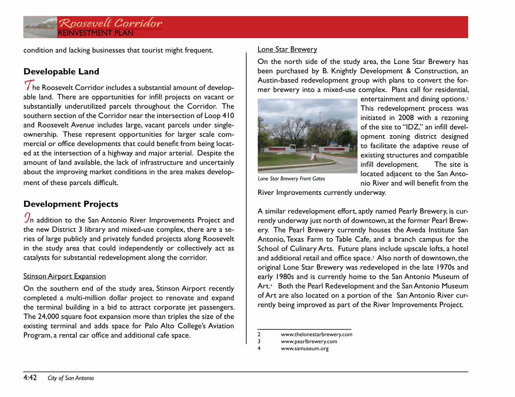
4:42 City of San Antonio
Roosevelt CorridorREinVEstMEnt PLan
Lone star Brewery
on the north side of the study area, the Lone star Brewery has been purchased by B. Knightly development & Construction, an austin-based redevelopment group with plans to convert the for-mer brewery into a mixed-use complex. Plans call for residential,
entertainment and dining options.2 this redevelopment process was initiated in 2008 with a rezoning of the site to “IDZ,” an infill devel-opment zoning district designed to facilitate the adaptive reuse of existing structures and compatible infill development. The site is located adjacent to the san anto-nio River and will benefit from the
River improvements currently underway.
a similar redevelopment effort, aptly named Pearly Brewery, is cur-rently underway just north of downtown, at the former Pearl Brew-ery. the Pearl Brewery currently houses the aveda institute san antonio, texas farm to table Cafe, and a branch campus for the school of Culinary arts. future plans include upscale lofts, a hotel and additional retail and office space.3 also north of downtown, the original Lone star Brewery was redeveloped in the late 1970s and early 1980s and is currently home to the san antonio Museum of art.4 Both the Pearl Redevelopment and the san antonio Museum of art are also located on a portion of the san antonio River cur-rently being improved as part of the River improvements Project.
2 www.thelonestarbrewery.com3 www.pearlbrewery.com4 www.samuseum.org
condition and lacking businesses that tourist might frequent.
Developable Land
The Roosevelt Corridor includes a substantial amount of develop-able land. There are opportunities for infill projects on vacant or substantially underutilized parcels throughout the Corridor. the southern section of the Corridor near the intersection of Loop 410 and Roosevelt avenue includes large, vacant parcels under single-ownership. these represent opportunities for larger scale com-mercial or office developments that could benefit from being locat-ed at the intersection of a highway and major arterial. despite the amount of land available, the lack of infrastructure and uncertainly about the improving market conditions in the area makes develop-ment of these parcels difficult.
Development Projects
In addition to the san antonio River improvements Project and the new district 3 library and mixed-use complex, there are a se-ries of large publicly and privately funded projects along Roosevelt in the study area that could independently or collectively act as catalysts for substantial redevelopment along the corridor.
stinson airport Expansion
on the southern end of the study area, stinson airport recently completed a multi-million dollar project to renovate and expand the terminal building in a bid to attract corporate jet passengers. the 24,000 square foot expansion more than triples the size of the existing terminal and adds space for Palo alto College’s aviation Program, a rental car office and additional cafe space.
Lone Star Brewery Front Gates
City of San Antonio 4:43
REinVEstMEnt PLanRoosevelt CorridorREinVEstMEnt PLan
Mission Power Plant
nearby, the Mission Power Plant has also been studied for its re-development potential. similar redevelopment projects to the one planned at the Mission Power Plant are underway or have been completed in communities close to san antonio. in new Braunfels, Texas, the historic coal-fired Comal Power Plant located on the Co-mal River has been redeveloped into upscale lofts, shops and office space following a 9 year, $11.5 million environmental remediation of the building and site performed by the Lower Colorado River Authority (LCRA), the final users of the power plant. Traditional garden style apartments were constructed on the open portions of the property.5 in austin, texas, the redevelopment of the former City of austin seaholm Power Plant promises to bring a new, mixed-use development to the edge of downtown. Located on town Lake, the 1950s era, art-deco style building will be recommissioned as the centerpiece of a 7.8 acre site including office space, lofts, retail space, and a boutique hotel. a Master development agreement for the site was approved by austin City Council in april 2008 with the grand opening scheduled for mid 2011.6
Espada
Just south of 410, the Espada development promises to bring a mix of housing types to the southside along with new neighborhood commercial and community commercial nodes. the terraMark de-velopment group based in sugar Land, texas is in the planning and permitting stages for this new greenfield development.
5 www.landmarklofts.com6 www.seaholm.info
Community Involvement
The support of the community will be essential to the realizing the redevelopment of the Roosevelt Corridor. Community involve-ment and support is necessary for the preparation and adoption of the Reinvestment Plan, spearheading of the community-iniated rein-vestment strategies, and ongoing plan implementation. the Planning team consists of community members and includes members from the neighborhood associations located within the boundaries of the Corridor. attendance at Planning team and Public Meetings has been robust, with the community embracing the idea of breathing new life into the tired Corridor.

Roosevelt CorridorREinVEstMEnt PLan
4:44 City of San Antonio
this page intentionally left blank.

REinVEstMEnt PLanRoosevelt CorridorREinVEstMEnt PLan
REinVEstMEnt PRioRitiEsCHaPtER 5:

Roosevelt CorridorREinVEstMEnt PLan
this page intentionally left blank.
City of San Antonio 5:47
REinVEstMEnt PLanRoosevelt CorridorREinVEstMEnt PLan
5: PRioRitiEs
With the substantial level of disinvestment and neglect found in the Roosevelt Corridor and the reality of finite financial resources made all the more limited by a deep and pronounced economic downturn, the need to prioritize investment was clear. one of the primary functions of the Planning Team included the identification and prioritization of projects and strategies to maximize the impact of public and private investment in the Roosevelt Corridor. the Planning team sought to select projects and strategies that could have the greatest impact relative to cost and implementation time frames.
Based on discussions with the Planning team during the visioning exercise undertaken in the 1st Planning team meeting, projects/ strategies were divided into 4 categories: infrastructure, short-term reinvestment strategies, long-term reinvestment strategies, and identifying/creating sources of funding to help property owners make improvements. the Planning team divided into 3 commit-tee workgroups to identify and prioritize projects within the infra-structure, short-term reinvestment strategies, and long-term rein-vestment strategies categories. the greater Planning team selected priority projects/ strategies from among the lists generated by the Committee Workgroups. staff worked with the CdaC and other public and private financing professionals on the fourth category: identifying/ creating sources of funding to assist property owners with improvements.
the following 8 priorities emerged:
1. Enhance landscaping by improving maintenance at public facilities, adding landscaping to currently barren islands
in the right-of-way, and providing landscaping along the frontages.
2. install public art at gateways and to mark important loca-tions
3. Amortize graffiti in tagging “hotspots”4. Compel compliance with City Codes5. Redesign the Roosevelt right-of-way cross section to
include bicycle lanes, sidewalks and landscaped medians where the width of the existing right-of-way permits
6. Enhance or provide drainage infrastructure at dangerous intersections and along the majority of the Corridor
7. adopt a community commercial model for allowed uses and site and building design standards for new commer-cial construction
8. identify sources of funding to assist property owners with improvements
the following sections describe these priorities in greater detail with descriptions of specific projects in identified locations.
Quality of Life
The quality of life priorities include projects with a short-term and ongoing implementation time-frame. these projects are primarily community based and/or community-driven and generally make use of existing programs and capacity. the quality of life priorities are aimed at improving the overall quality of life in the community. Priority projects in this category were selected for their benefits relative to cost and implementation time frames. the Committee Workgroup initially identified 34 site-specific, quality of life projects that included landscaping enhancements, public art installation, graf-fiti abatement, and code compliance. The Planning Team narrowed this list by agreeing on a select group of priority projects. these
5:48 City of San Antonio
Roosevelt CorridorREinVEstMEnt PLan
priority projects are described below:
LandsCaPing EnHanCEMEnts
the Planning team prioritized 13 individual landscaping enhance-ment projects. the Planning team recognizes the importance of providing native, drought tolerant vegetation in urbanized areas to reduce the heat island effect, allow for goundwater recharge, re-duce pollutant conveyance to the san antonio River, provide habitat for wildlife, and for aesthetic purposes. trees placed close to the sidewalk provide shade for pedestrians and enhance the pedestrian experience.
Many of the properties along the Roosevelt Corridor were devel-oped at a time when the City of san antonio had no landscaping or tree preservation requirements. other properties were developed prior to annexation into the City limits. as a result, tree cover in the Corridor is sparse, and many properties have little or no per-vious cover. the bar ditches that originally acted as stormwater conveyance devices have in many cases been filled and paved-over which reduces groundwater recharge and contributes to drainage problems in the area.
The landscaping projects identified by the Planning Team range from enhanced tree and landscaping maintenance at publicly-owned facil-ities, to adding landscaping to right-of-way islands at major intersec-tions, to adding landscaping along large swaths of frontage currently lacking landscaping. Below is a list of the priority projects:
tree trimming & Maintenance
Riverside golf Coursestinson Municipal airportstinson Park
•••
Historical Marker north of Riverside golf Course
Landscape Right-of-Way islands at intersections
Roosevelt & Hf McCartyRoosevelt & KellyRoosevelt & VfW
add Landscaping to street frontage
grove to yellowstonesa River to southcrossstinson airport frontageHarlandale isd stadium frontageashley to Loop 410stinson Park frontage
PUBLiC aRt instaLLation
The Planning Team identified 3 priority areas for the installation of public art. the Planning team recognizes the importance of includ-ing public art in the Corridor. Public art will create an identity for the Roosevelt Corridor and let people know they have entered a special place rich in history, cultural heritage, and natural beauty. Public art can help restore the lost connections between the Roos-evelt Corridor and the san antonio River. Public art also provides an opportunity for local artisans to showcase their talents in highly visible and important locations.
the Planning team selected 3 priority areas for the installation of public art. all are located on publicly owned property which simpli-fies and expedites the installation process.
•
•••
••••••
City of San Antonio 5:49
REinVEstMEnt PLanRoosevelt CorridorREinVEstMEnt PLan
Roosevelt Park
The first location identified by the Planning Team is at the northern gateway to the Roosevelt Corridor near the intersection of Roos-evelt avenue and Lone star Boulevard. West of the right-of-way lies Roosevelt Park, a popular park with mature trees that recently benefited from enhancements including a new reception hall, pool, and play ground equipment. the western portion of the park lies on the banks of the san antonio River. this section of the san an-tonio River lies just below the tunnel outlet structure at Lone star Boulevard and has long been neglected. the park improvements are separated from the san antonio River by Mission drive; a tan-gible example of how the City has “turned its back” on this sec-tion of the san antonio River. When the improvements currently underway are completed, the san antonio River will provide a new amenity and a new focus for Roosevelt Park. Roosevelt Park will be a gateway entrance to the san antonio River trail. installing public art near the right-of-way will signal travelers that they are enter-ing a special place and draw their attention to Roosevelt Park and the san antonio River, restoring an important link from Roosevelt avenue to the River.
Roosevelt Bridge at the san antonio River
The Planning Team identified the Roosevelt Avenue bridge that crosses the san antonio River as an important location for the in-stallation of public art. in its current state, the bridge is discon-nected both physically and psychologically from the meandering River and park below. due to a substantial change in grade caused by the carving out of the river channel by periodic flooding, the elevation differnce between the river banks and the bridge is quite substantial. Pedestrian connections to the park and river below are nonexistent. While the Riverside golf Course is visible, one might traverse the bridge without knowing the san antonio River lies
below. Public art installed at the northern and southern entrances to the bridge would signal the importance of the River below. a wayfinding system should also be included to help pedestrians, bicy-clists, and motorists find access points to the River below.
Mission drive-in Redevelopment
The Planning Team identified the southern property line separating the former Mission drive-in site from the Mission san Jose grounds as an important location for the installation of public art. such an in-stallation would connect the former Mission drive-in site, currently being redeveloped into the home of the new district 3 branch li-brary and mixed-use complex, to the Mission san Jose grounds to the south. Public art at this location would connect the new library to the Mission and signalize and end to the understandably tenuous relationship between a multi-screen outdoor movie theater and one of the oldest missions in the United states.
gRaffiti aBatEMEnt
Graffiti pops up in nearly every corner of the City, at least on occa-sion. It’s the slow removal or proliferation of graffiti that might lead to the perception that an area is crime ridden, impoverished, and neglected even if this is not necessarily the truth. it is important for a community to combat graffiti through quick removal and by making changes to the built environment that make tagging more difficult and allow for increased surveillance (i.e. eyes on the street). Graffiti is prevalent in most sections of the Roosevelt Corridor. The Planning Team identified an area on the west side of Roosevelt just north of Military Drive where graffiti has been especially preva-lent. If only this area is addressed, the graffiti is likely to show up elsewhere in the Corridor. A community-based graffiti abatement program could address the entire corridor and focus on hot-spots as they emerge.
5:50 City of San Antonio
Roosevelt CorridorREinVEstMEnt PLan
CodE CoMPLianCE
Similar to the proliferation of graffiti, code compliance violations such as overgrown weeds, junked vehicles, and dumping might lead to the perception that an area is crime ridden, impoverished, and neglected even if this is not the case. these and other code viola-tions may also endanger the public health and safety. the City’s Code Compliance division enforces City Codes, including zoning codes, to protect the health, safety and welfare of all citizens. the Planning team recognized the importance of compelling compliance with City Codes. although Code enforcement is ultimately the re-sponsibility of the Code Compliance Officer, a community can as-sist with process by notifying the Code Compliance division about violations in their area, and organizing community clean-ups, and assisting neighbors who due to financial, health, or other hardship may be unable to quickly address a code compliance violation. the Planning Team identified 3 areas where code compliance violations are common and problematic. these areas are listed below:
Roosevelt from grove to iH-10Roosevelt from iH-10 to isabelRoosevelt from ashley to Loop 410
Similar to graffiti, while a targeted effort is often required to deal with hot-spots, violations tend to pop-up elsewhere unless there is an ongoing program in place to identify and help address code compliance violations.
Land Use Management
The land use management priorities tend to have a longer imple-mentation time frame although immediate action may be necessary
•••
to adopt regulations. the land use management priorities include a corridor-wide base rezoning and the adoption of a corridor zon-ing overlay district with unique site and building design standards. although the new base zoning districts and overlay zoning districts may be adopted in the short-term, seeing the results of the new regulations may take time. Property owners are protected by non-conforming rights (often referred to as ‘grandfathering’) which al-low them to maintain an existing use or structure even if it does not conform to what is allowed under the current regulations. Howev-er, as vacant properties are developed, vacant building rehabilitated and uses that serve the community established, property owners with non-conforming uses or structures may feel financial pressure brought on by the changing market and elect to bring their use or building into conformance.
CoRRidoR BasE REZoning
a corridor-wide base rezoning along the Roosevelt Corridor is necessary to ensure the base zoning allows for future development that is consistent with the goals of the adopted plans and the goals expressed by the Planning team. the base zoning district assigned to a property determines how a property may be developed and used. the overall purpose of zoning is to protect the health, safety and welfare of the public by reducing the potential for conflict be-tween incompatible land uses, and to generally promote a more or-derly and sustainable pattern of development. Base zoning districts always include regulations on use. some also include limits on density, building setback requirements, and height restrictions.
the City of san antonio relies on a set of conventional zoning districts that generally segregate different categories of uses. for example, the residential zoning districts primarily allow for resi-dential uses, commercial zoning districts primarily allow for retail
City of San Antonio 5:51
REinVEstMEnt PLanRoosevelt CorridorREinVEstMEnt PLan
uses, industrial districts primarily allow for industrial uses, and so on. Within each category of uses there are subdistricts based on building form and the intensity of uses. for example, there are 4 base zoning districts in the commercial category: “nC” and “C1” for neighborhood Commercial, “C2” for Community Commercial, and “C3” for Regional Commercial.
in addition to these “conventional” zoning districts, the City has adopted several special zoning districts designed to address unique situations, accommodate the latest advances in planning theory, encourage development in specific locations, or generally allow for a form of development which is desired but would otherwise not be permitted in one of the conventional zoning districts. Examples of special districts include “IDZ” Infill Development Zone District which makes developing small, vacant parcels in urbanized areas possible, and the “MXd” Mixed Use district, which makes it pos-sible to create master-planned communities that incorporate a health mix of uses from different categories.
Since the first zoning code was adopted in 1938, the City has fre-quently revised the zoning codes to reflect changes in the prevail-ing development pattern and address new uses, building types and situations. the City has undergone 2 major revisions to the zoning code, the latest in 2002. in each case, when the new zoning clas-sification was adopted, it included converting the existing zoning districts to new zoning districts. these processes have generally led to an “over-zoning” of many of the central city neighborhoods, whereby the adopted zoning permits uses of an intensity and size that are not compatible with the existing development pattern. this is certainly the case with the Roosevelt Corridor.
Many of the properties in the Corridor are zoned for Regional
Commercial uses. Regional Commercial uses are typically found in nodes at the intersections of highways or highways and major arterials. Central city arterials generally do not carry the volume of traffic necessary to support new, large Regional Commercial shop-ping centers. it is often a misconception that it is best to have the zoning district which allows for the highest intensity and largest-scale developments. over-zoning an area will not bring regional commercial uses if the market does not support them - rather it will lead to a disjointed collection of uses of varying intensities that do not properly relate or serve nearby residential areas. along Roosevelt, this includes an over proliferation of motels, bars and auto-oriented businesses. in a central city community, the goal is to match the zoning with the existing development pattern to allow for uses that will serve and properly relate to the area.
the adopted south Central san antonio Community Plan and stin-son aiport Vicinity Plan include future land use maps developed through a community-based process and endorsed by City Council. these future land use maps identify the preferred land development pattern based on the existing development pattern and the goals of the adopted plans. While these land use maps are not regulatory in nature, and do not establish zoning district boundaries, they serve as a guide for rezoning initiatives. the base rezoning of the Roos-evelt Corridor will follow the land use maps included with these adopted plans.
MEtRoPoLitan CoRRidoR oVERLay distRiCt
in addition to the corridor-wide base rezoning, the adopted plans and the Planning team have recommended the adoption of a cor-ridor overlay zoning district with site and building design standards unique to the Roosevelt Corridor. Zoning overlay districts address special use, siting, and compatibility issues which require use and
5:52 City of San Antonio
Roosevelt CorridorREinVEstMEnt PLan
development regulations in addition to those found in the base zon-ing district.
over the years, the City of san antonio has adopted several dif-ferent zoning overlay districts. the River improvement overlay districts (Rio) protect, preserve, and enhance the san antonio River and its improvements by establishing design standards and guidelines for properties located near the river.7 the neighbor-hood Conservation districts (nCd) are designed to protect and strengthen unique or distinctive neighborhoods or commercial dis-tricts by establishing design guidelines for new construction that are compatible with the design of existing structures.8 the Corridor overlay districts (Cod) are designed to preserve, enhance and perpetuate the value of roadway corridors that serve as gateways to the city, serve as traditional neighborhood centers or because of surrounding natural, cultural, historic, or aesthetic areas.9
the Cod program includes allows for the establishment of 3 dis-tinct types of corridor overlay districts that are designed to accom-modate a range of corridor types: gateway Corridors for developed and undeveloped sections of major highways, Metropolitan Cor-ridors for developed arterials and expressways, and Preservation Corridors for roadways with historical significance, natural vistas, or unique scenic environments. adopted corridor overlay districts are classified as one of the above types and include unique site and building design standards developed through a public participation process and adopted by City Council.10 the Roosevelt Corridor
7 Unified Development Code 35-3388 Unified Development Code 35-3359 Unified Development Code 35-339.0110 section 35-339.01 of the UdC outlines the designation criteria, initiation procedures, public participation process, allowable site and building design elements, and administration processes for the Corridor overlay districts in greater detail.
is eligible for designation as a Metropolitan Corridor overlay dis-trict.
the unique site and building design standards adopted as part of a Metropolitan Corridor overlay district for the Roosevelt Corridor could are essential to place-making, that is giving an area a unique character and qualities that set it apart from the norm and make people want to linger. the design standards included as part of a corridor overlay district do not necessarily need to equate to high-er building costs; the massing of buildings, placement of parking, uti-lization of unifying elements, and a more compact design alone can create a unique place. The Committee Workgroup identified site and building design elements appropriate for the corridor. these and others were presented to the Planning team to establish design preferences for the area. the following elements were prioritized by the Planning team.
Building orientation – community commercial model (me-dium lot size, located at intersections of arterials, or along arterials)Building Massing – community commercial model (moder-ate front building setback, multiple tenants)Parking – minimize parking in front; overflow parking in rearBuilding Materials – masonry (brick, stucco, stone) with al-lowances for unique accent materialsLighting – specialized lighting fixtures on public and/or pri-vate property (use candy cane fixtures as model)screening (trash Receptacles) – walled enclosure w/gatesscreening (Parking Lots) – landscaping and low wallssignage – projecting sign & awning sign (other sign types also selected with relative frequency)
•
•
•
•
•
•••
City of San Antonio 5:53
REinVEstMEnt PLanRoosevelt CorridorREinVEstMEnt PLan
front Buffer – opportunistic (shallow landscaped area be-tween sidewalk and building)
Infrastructure
The infrastructure priorities have a mid- to long-term implemen-tation time frame due to the time required to finance, design and construct this type of project. Well functioning infrastructure is an essential for attracting investment to a central city community. The Roosevelt Corridor is burdened with significant deficiencies in the existing infrastructure. These deficiencies include a lack of storm water conveyance structures, poor street design, and a lack of sidewalks.
the Planning team recognizes the importance of infrastructure im-provements to the successful revitalization of the Roosevelt Cor-ridor. the Planning team was charged with identifying those infra-structure projects whose completion are the most critical to the redevelopment of the area. the infrastructure Priorities Commit-tee Workgroup identified 19 projects that include improvements to existing, or the construction of new street, sidewalk and drainage infrastructure. the Planning team whittled this down to a list of 13 priority projects. those projects are described below.
dRainagE
the lack of storm water infrastructure leads to dangerously high water levels at several major intersections during heavy rain. the pooling and ponding of water at low spots throughout the Corridor may persist for days after the rain has ended. the bar ditches that originally collected and conveyed storm water away from the road-way have in many cases been paved over without the addition of an underground storm water conveyance system. The water flows
• from the bar ditches that remain are often impeded by obstructions further down the line. The Planning Team identified the following drainage projects as priorities:
Railroad Underpass north of Lone star Boulevardintersection of Roosevelt & Whartonintersection of Roosevelt & Hf McCartyintersection of Roosevelt & White/ VfWintersection of Roosevelt & san Jose/ Pachecointersection of Roosevelt & Hardingintersection of Roosevelt & floresimprovements from March to Loop 410
stREEts
the existing street design of Roosevelt avenue creates hazardous conditions for both pedestrians and vehicles. the majority of the right-of-way does not include curbs or other barriers to slow or stop out-of-control cars from leaving the travel lanes and exposing pedestrians and structures to injury and damage. Even though the paved area of the right-of-way in most sections of the Corridor is wide enough to accommodate motorized vehicles and bicycles, bicycle lanes are not marked. Poorly defined or excessively large curb cuts also create conflicts between vehicles and between ve-hicles and pedestrians. although a redesign of the cross-section of Roosevelt along the entire Corridor is desirable, the Planning team was asked to identify areas where improvements to the existing street design are most necessary for encouraging redevelopment. The priority projects that were identified are described below:
Provide direct access to iH-10 from Roosevelt11
11 Providing direct access to iH-10 from Roosevelt would require substantial land acquisition. Clarifying routes with wayfinding signage may be an acceptable alternative
••••••••
•
5:54 City of San Antonio
Roosevelt CorridorREinVEstMEnt PLan
add landscaped medians to Roosevelt from McMullen to the san antonio RiverReplace the signalized intersection at Roosevelt & White/VFW with a traffic circle
sidEWaLKs
sidewalks are provided only sporadically along the Corridor. nar-row sidewalks located next to the back of the curb are present along Roosevelt in the northern section of the Corridor. Many of these sidewalks are in poor condition and frequently intruded upon by utility poles. sidewalks are provided only sporatically south of Riverside golf Course and are non-existent south of March. When combined with the excessively large curb cuts and lack of barriers for the travel lanes, this lack of a predicable pattern of sidewalks creates an extremely unsafe and unpleasant circumstance for pe-destrians attempting to navigate through the Corridor or access one of the many and often used bus stops in the Corridor. sidewalk improvements may often be made in conjunction with drainage and street repairs. The Planning Team identified 2 priority projects de-scribed below:
Replace sunken sidewalks at Roosevelt ParkProvide pedestrian access over bridge at the sa River
Improvement Funds
Identifying and/ or creating funding sources for the projects and strategies is a priority for all projects identified in the Reinvest-ment Plan. The Planning Team identified the need for a revolving source of funds to help property owners make improvements to private property - specifically related to site and building design. the design standards created as part of the overlay district apply
•
•
••
to new construction only. in order to expedite the redevelop-ment of the Corridor, a replenishing source of funds to help pri-vate property owners make improvements to their property must be identified or created.

REinVEstMEnt PLanRoosevelt CorridorREinVEstMEnt PLan
REinVEstMEnt stRatEgiEsCHaPtER 6:

Roosevelt CorridorREinVEstMEnt PLan
this page intentionally left blank.
City of San Antonio 6:57
REinVEstMEnt PLanRoosevelt CorridorREinVEstMEnt PLan
6: REinVEstMEnt stRatEgiEs
This Chapter of the Reinvestment Plan includes background infor-mation on the City of San Antonio’s Infill and Reinvestment Policy as well as the specific Reinvestment Strategies developed for the Roosevelt Corridor.
Infill and Reinvestment Policy
The City of san antonio has demonstrated a commitment to ur-ban infill and redevelopment by developing an Infill and Reinvest-ment Policy (i&RP) as a component of the strategic Plan for Com-munity development. the Roosevelt Corridor Reinvestment Plan has been developed within the framework of the Citywide i&RP. the i&RP is summarized below:
a. PoLiCy statEMEnt
it is the policy of the City of san antonio to promote growth and development in the heart of the City, specifically in areas that are currently served by public infrastructure and transit, but under-served by residential and commercial real estate markets. it is the intent of this policy to coordinate public initiatives within targeted areas in order to stimulate private investment in walkable urban communities that are the building blocks of a sustainable region. To accomplish the objectives of the Infill and Reinvestment Policy, the entire range of public incentives is provided under this policy, including regulatory, procedural, and financing incentives.
B. PUBLiC BEnEfits
The benefits of a successful Infill & Reinvestment Policy (I&RP) ac-crue not only to targeted neighborhoods, but to the City as a whole. in addition to placing vacant properties back into productive activ-
ity, the i&RP reduces development pressure on sensitive agricultural and environmental land on the periphery of the City of san antonio, and reduces the need to build new infrastructure by making more efficient use of existing infrastructure.
C. PoLiCy goaLs
The goals of the Infill & Reinvestment Policy are:
increase new development (housing and commercial) on vacant lotsincrease redevelopment of underused buildings and sitesincrease rehabilitation, upgrade, adaptive reuse of existing buildingsimprove maintenance of existing buildings and sitesincrease Business recruitment and assistance
d. stRatEgiC PRinCiPLEs
Implementation of the Infill & Reinvestment Policy should be built around five key principles.
Comprehensive ReinvestmentCoordination: Reinvestment is a Public Private PartnershipConcentrate Efforts: targeted areasAddress the Challenges to InfillEstablish sustainable design and development standards
E. iMPLEMEntation
a strategy has been developed to coordinate four initiatives within targeted areas. the primary target area follows the CRag bound-aries, and Reinvestment Plan areas are designated within Loop 410. the four initiatives include Reinvestment Planning, Land Bank-ing, Upgraded incentive scorecard system, and interdepartmental oversight / single Point of Contact.
1.
2.3.
4.5.
1.2.3.4.5.
6:58 City of San Antonio
Roosevelt CorridorREinVEstMEnt PLan
Reinvestment Strategy 1:LEVERAgE RIVER IMPROVEMENTS &
MISSION DRIVE-IN REDEVELOPMENT
the enhancements planned as part of the Mission Reach of the san antonio River improvements Project and the Mission drive-in Redevelopment will dramatically enhance conditions within the project boundaries. these publicly funded projects were designed specifically for that purpose. The question is how these projects will impact adjacent properties and the surrounding communities.
these projects will bring visitors and jobs to the area. With the appropriate actions, these ‘visitors’ could also be customers for lo-cal businesses and these ‘new jobs’ could equal employment op-portunities for existing residents and an opportunity to attract new residents to the area. new residents could translate into additional customers for the local businesses. the primary purpose of this Reinvestment Plan is to identify and set out a strategy so adjacent property owners and the greater community can seize these op-portunities provided by these projects and use them to embark on a comprehensive redevelopment effort.
the following action steps (as well as many of the action items found within the 6 other Reinvestment strategies) are designed to connect the greater community to the River improvements and Mission drive-in Redevelopment site.
For more detailed information on these action steps, including partners and resources, see the Action Matrix.
1.1 Provide physical and visual connections from Roosevelt av-enue to the san antonio River.
Corridor Reinvestment Strategies
This section includes a description of 7 Reinvestment strategies that are essential to the redevelopment of the Roosevelt Corridor. These Reinvestment Strategies are a set of specific initiatives based on the infrastructure Priorities, short-term Reinvestment Priori-ties, and Long-Term Reinvestment Priorities identified by the Plan-ning team and listed in the previous chapter.
The over-arching goal of this plan is to encourage re-investment in the Roosevelt Corridor. achieving this will require the following actions:
Leverage River Improvements & Mission Drive-In RedevelopmentInvest in drainage, street and sidewalk infra-structurePhase out high intensity commercial and industrial zoningAdopt unifying design standards for new con-structionLaunch community-based initiatives to im-prove quality of lifeLink existing business & property owners with funding sourcesCreate investment opportunities
•
•
•
•
•
•
•
Actions steps are listed and briefly described in the following sec-tions. for more detailed information on these action steps, includ-ing partners and resources, see the action Matrix.
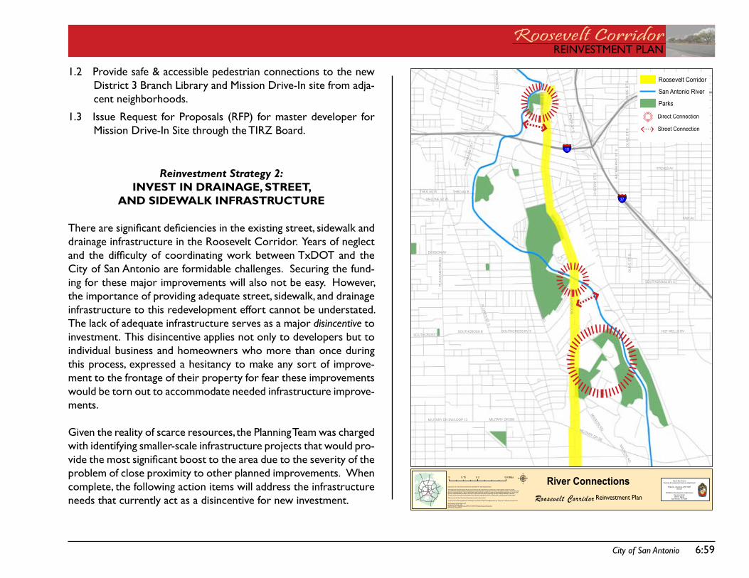
City of San Antonio 6:59
REinVEstMEnt PLanRoosevelt CorridorREinVEstMEnt PLan
1.2 Provide safe & accessible pedestrian connections to the new district 3 Branch Library and Mission drive-in site from adja-cent neighborhoods.
1.3 issue Request for Proposals (RfP) for master developer for Mission drive-in site through the tiRZ Board.
Reinvestment Strategy 2:INVEST IN DRAINAgE, STREET,
AND SIDEwALk INFRASTRUCTURE
There are significant deficiencies in the existing street, sidewalk and drainage infrastructure in the Roosevelt Corridor. years of neglect and the difficulty of coordinating work between TxDOT and the City of san antonio are formidable challenges. securing the fund-ing for these major improvements will also not be easy. However, the importance of providing adequate street, sidewalk, and drainage infrastructure to this redevelopment effort cannot be understated. the lack of adequate infrastructure serves as a major disincentive to investment. this disincentive applies not only to developers but to individual business and homeowners who more than once during this process, expressed a hesitancy to make any sort of improve-ment to the frontage of their property for fear these improvements would be torn out to accommodate needed infrastructure improve-ments.
given the reality of scarce resources, the Planning team was charged with identifying smaller-scale infrastructure projects that would pro-vide the most significant boost to the area due to the severity of the problem of close proximity to other planned improvements. When complete, the following action items will address the infrastructure needs that currently act as a disincentive for new investment.
PR
ES
AS
TS
FLOR
ES
ST
S
RO
OS
EV
ELT
AV
STEVES AV
MIS
SION
RD
FAIR AV
PLE
AS
AN
TON
RD
NE
WB
RA
UN
FE
LSA
VS
HA
CK
BE
RR
YS
TS
MILITARY DR SE
RIGSBY AV
THEO AV E
SOUTHCROSS BV E HOT WELLS BV
DIVISION AVP
RO
BA
ND
TS
T
THEO AV W
MILITARY DR SW/LOOP 13
SOUTHCROSS E
MALONE ST W
ST
MA
RY
SS
TS
MILITARY DR SW
SOUTHCROSS W
CH
ER
RY
ST
S
OLI
VE
ST
S
MISSIO
NRD
MISSIO
NRD
SOUTHCROSS BV E
OLI
VE
ST
S
PR
OB
AN
DT
ST
OLI
VE
ST
S
§̈¦10
§̈¦37
µData Source: City of San Antonio Enterprise GIS, Bexar Metro 911, Bexar Appraisal District
"This Geographic Information System Product received from the City of San Antonio is provided "as is" without warranty of any kind, and theCity of SanAntonio expressly disclaims all expressed and implied warranties, including but not limited to the implied warranties of merchantability andfitness for a particular purpose. The City of SanAntonio does not warrant, guarantee, or make any representations regarding the use, or the resultsof the use, of the information provided to you by the City of SanAntonio in terms of correctness, accuracy, reliability, timeliness or otherwise.The entire risk as to the results and performance of any information obtained from the City of San Antonio is entirely assumed by the recipient."
"Please contact the City of SanAntonio Department for specific determinations."
City of SanAntonio Planning Department GIS Manager: Dale Woodruff, [email protected]. Maps may be ordered at (210) 207-7873.
Map Created by: Michael Taylor, AICPMap Creation Date: May 2009Map File Location: K:\Neighborhoods\OVERLAY DISTRICTS\Studies\Roosevelt MetropolitanPDF Filename: AdoptedPlans
Roosevelt Corridor
River Connections0 0.3 0.60.15 MilesCity of San Antonio
Planning & Development Services Department
Roderick J. Sanchez, AICP, CBODirector
Cliff Morton Development and BuisinessServices Center1901 S. Alamo
San Antonio, TX 78204
Roosevelt Corridor
San Antonio River
Parks
Reinvestment Plan
Direct Connection
Street Connection
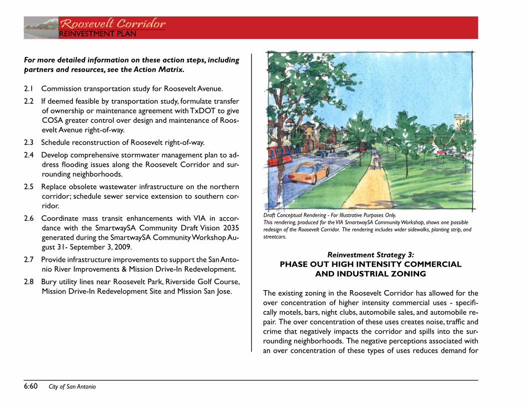
6:60 City of San Antonio
Roosevelt CorridorREinVEstMEnt PLan
For more detailed information on these action steps, including partners and resources, see the Action Matrix.
2.1 Commission transportation study for Roosevelt avenue.
2.2 if deemed feasible by transportation study, formulate transfer of ownership or maintenance agreement with txdot to give Cosa greater control over design and maintenance of Roos-evelt avenue right-of-way.
2.3 schedule reconstruction of Roosevelt right-of-way.
2.4 develop comprehensive stormwater management plan to ad-dress flooding issues along the Roosevelt Corridor and sur-rounding neighborhoods.
2.5 Replace obsolete wastewater infrastructure on the northern corridor; schedule sewer service extension to southern cor-ridor.
2.6 Coordinate mass transit enhancements with Via in accor-dance with the smartwaysa Community draft Vision 2035 generated during the smartwaysa Community Workshop au-gust 31- september 3, 2009.
2.7 Provide infrastructure improvements to support the san anto-nio River improvements & Mission drive-in Redevelopment.
2.8 Bury utility lines near Roosevelt Park, Riverside golf Course, Mission drive-in Redevelopment site and Mission san Jose.
Reinvestment Strategy 3:PHASE OUT HIgH INTENSITy COMMERCIAL
AND INDUSTRIAL ZONINg
the existing zoning in the Roosevelt Corridor has allowed for the over concentration of higher intensity commercial uses - specifi-cally motels, bars, night clubs, automobile sales, and automobile re-pair. The over concentration of these uses creates noise, traffic and crime that negatively impacts the corridor and spills into the sur-rounding neighborhoods. the negative perceptions associated with an over concentration of these types of uses reduces demand for
Draft Conceptual Rendering - For Illustrative Purposes Only.This rendering, produced for the VIA SmartwaySA Community Workshop, shows one possible redesign of the Roosevelt Corridor. The rendering includes wider sidewalks, planting strip, and streetcars.
City of San Antonio 6:61
REinVEstMEnt PLanRoosevelt CorridorREinVEstMEnt PLan
nearby properties, which in turn lowers property values. Many of the community serving uses that were once prevalent along Roos-evelt avenue closed as the Corridor saw a steady increase in the number of bars and low-priced motels. a corridor-wide rezoning can address these issues by reducing the intensity of commercial uses that are allowed to be established in the future, thereby phas-ing out non-contributing uses.
on the positive side, this corridor-wide rezoning will set the stage for the establishment of community serving uses that are compat-ible with the surrounding neighborhoods and that complement the historic, cultural and natural assets of the area. Examples of com-patible community commercial uses include: cafes, offices, restau-rants, barber/ beauty shops, neighborhood grocers or markets, shoe repair, and medical offices. Community commercial may include a limited amount of residential uses if combined with non-residential uses (i.e the traditional shopkeepers set-up with residential space on the upper floor of a retail building). These are the types of uses that were once prevalent along Roosevelt avenue and that can be reestablished if the high intensity commercial and industrial uses and accompanying problems are limited in the future.
Portions of the corridor are appropriate for higher density, mixed-use nodes that incorporate community commercial, office, and high density residential uses in the same building or in the same develop-ment, feature high-quality urban design elements including ground floor retail on multi-story buildings, covered walkways, outdoor ca-fes, and seating areas. the Mission drive-in Redevelopment site is one such area that will be redeveloped in this manner. the north-ern portion of the Corridor near the proposed Lone star Brewery Redevelopment and Mission Power Plant Redevelopment would also benefit from this treatment.
For more detailed information on these action steps, including partners and resources, see the Action Matrix.
3.1 Rezone properties in the Corridor according to adopted fu-ture land use plans.
3.2 Monitor the establishment of new uses.
Reinvestment Strategy 4:ADOPT UNIFyINg DESIgN
STANDARDS FOR NEw CONSTRUCTION
the san antonio River improvements, Mission drive-in Redevelop-ment, stinson airport expansion, and other publicly funded improve-ments are expected to create demand for development within the Corridor. these projects incorporate high quality design and build-ing materials. they complement the historical and cultural assets found within the Corridor. By the sole existence of these improve-ments, but also through the incorporation of high quality design and building materials, these publicly funded projects will become assets to the community and especially adjacent land owners. it is expected that private property owners will demonstrate a similar commitment to the betterment of the Corridor through the use of complementary and high quality design and materials. to ensure this happens, it is necessary to adopt unifying design standards for new construction and create a fair and objective review process to facilitate the implementation of these standards. Community sup-port is also needed to motivate property owners to make needed improvements and monitor the corridor for illegal construction ac-tivity.
For more detailed information on these action steps, including
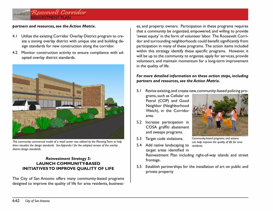
6:62 City of San Antonio
Roosevelt CorridorREinVEstMEnt PLan
partners and resources, see the Action Matrix.
4.1 Utilize the existing Corridor overlay district program to cre-ate a zoning overlay district with unique site and building de-sign standards for new construction along the corridor.
4.2 Monitor construction activity to ensure compliance with ad-opted overlay district standards.
Reinvestment Strategy 5:LAUNCH COMMUNITy-BASED
INITIATIVES TO IMPROVE QUALITy OF LIFE
the City of san antonio offers many community-based programs designed to improve the quality of life for area residents, business-
es, and property owners. Participation in these programs requires that a community be organized, empowered, and willing to provide ‘sweat equity’ in the form of volunteer labor. the Roosevelt Corri-dor and surrounding neighborhoods could benefit significantly from participation in many of these programs. the action items included within this strategy identify these specific programs. However, it will be up to the community to organize, apply for services, provide volunteers, and maintain momentum for a long-term improvement in the quality of life.
For more detailed information on these action steps, including partners and resources, see the Action Matrix.
5.1 Revive existing, and create new, community-based policing pro-grams, such as Cellular on Patrol (CoP) and good neighbor (neighborhood Watch), in the Corridor area.
5.2 increase participation in COSA graffiti abatement and sweeps programs.
5.3 target code violations.
5.4 add native landscaping to target areas identified in Reinvestment Plan including right-of-way islands and street frontage.
5.5 Establish partnerships for the installation of art on public and private property
This community commercial model of a retail center was utilized by the Planning Team to help them visualize the design standards. See Appendix I for the adopted version of the overlay district design standards.
Community-based programs and actions can help improve the quality of life for area residents.
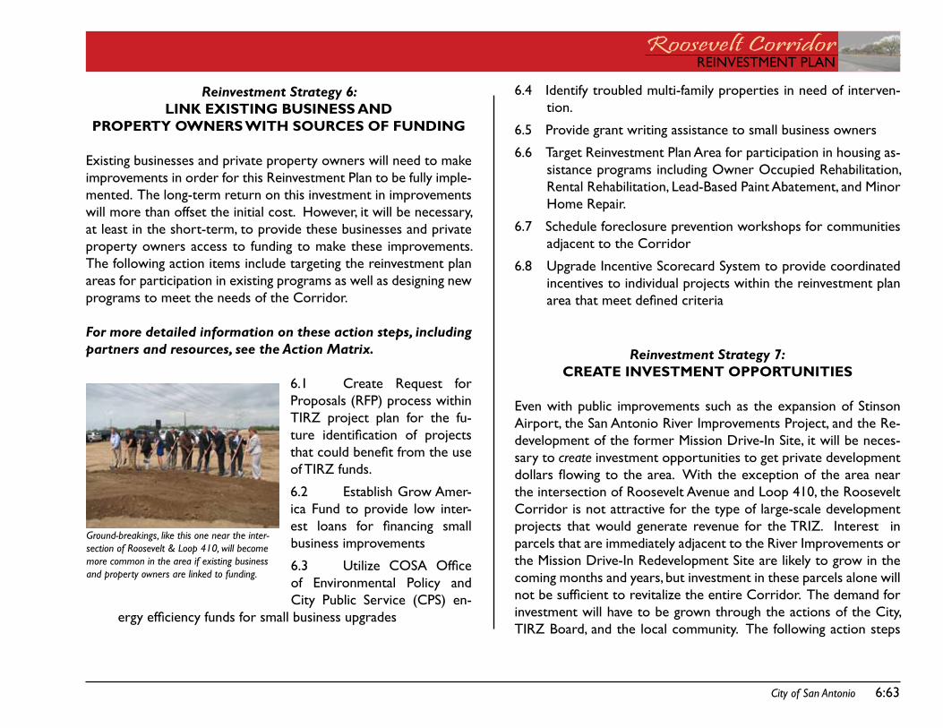
City of San Antonio 6:63
REinVEstMEnt PLanRoosevelt CorridorREinVEstMEnt PLan
Reinvestment Strategy 6: LINk ExISTINg BUSINESS AND
PROPERTy OwNERS wITH SOURCES OF FUNDINg
Existing businesses and private property owners will need to make improvements in order for this Reinvestment Plan to be fully imple-mented. the long-term return on this investment in improvements will more than offset the initial cost. However, it will be necessary, at least in the short-term, to provide these businesses and private property owners access to funding to make these improvements. the following action items include targeting the reinvestment plan areas for participation in existing programs as well as designing new programs to meet the needs of the Corridor.
For more detailed information on these action steps, including partners and resources, see the Action Matrix.
6.1 Create Request for Proposals (RfP) process within tiRZ project plan for the fu-ture identification of projects that could benefit from the use of tiRZ funds.
6.2 Establish grow amer-ica fund to provide low inter-est loans for financing small business improvements
�.3 Utilize COSA Office of Environmental Policy and City Public service (CPs) en-
ergy efficiency funds for small business upgrades
6.4 identify troubled multi-family properties in need of interven-tion.
6.5 Provide grant writing assistance to small business owners
6.6 target Reinvestment Plan area for participation in housing as-sistance programs including owner occupied Rehabilitation, Rental Rehabilitation, Lead-Based Paint abatement, and Minor Home Repair.
6.7 schedule foreclosure prevention workshops for communities adjacent to the Corridor
6.8 Upgrade incentive scorecard system to provide coordinated incentives to individual projects within the reinvestment plan area that meet defined criteria
Reinvestment Strategy 7:CREATE INVESTMENT OPPORTUNITIES
Even with public improvements such as the expansion of stinson airport, the san antonio River improvements Project, and the Re-development of the former Mission drive-in site, it will be neces-sary to create investment opportunities to get private development dollars flowing to the area. With the exception of the area near the intersection of Roosevelt avenue and Loop 410, the Roosevelt Corridor is not attractive for the type of large-scale development projects that would generate revenue for the tRiZ. interest in parcels that are immediately adjacent to the River improvements or the Mission drive-in Redevelopment site are likely to grow in the coming months and years, but investment in these parcels alone will not be sufficient to revitalize the entire Corridor. The demand for investment will have to be grown through the actions of the City, tiRZ Board, and the local community. the following action steps
Ground-breakings, like this one near the inter-section of Roosevelt & Loop 410, will become more common in the area if existing business and property owners are linked to funding.
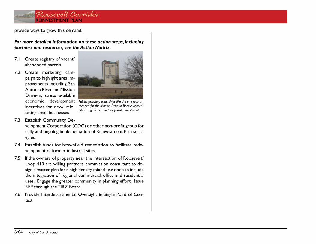
6:64 City of San Antonio
Roosevelt CorridorREinVEstMEnt PLan
provide ways to grow this demand.
For more detailed information on these action steps, including partners and resources, see the Action Matrix.
7.1 Create registry of vacant/ abandoned parcels.
7.2 Create marketing cam-paign to highlight area im-provements including san antonio River and Mission drive-in; stress available economic development incentives for new/ relo-cating small businesses
7.3 Establish Community de-velopment Corporation (CDC) or other non-profit group for daily and ongoing implementation of Reinvestment Plan strat-egies.
7.4 Establish funds for brownfield remediation to facilitate rede-velopment of former industrial sites.
7.5 if the owners of property near the intersection of Roosevelt/ Loop 410 are willing partners, commission consultant to de-sign a master plan for a high density, mixed-use node to include the integration of regional commercial, office and residential uses. Engage the greater community in planning effort. issue RfP through the tiRZ Board.
7.6 Provide interdepartmental oversight & single Point of Con-tact
Public/ private partnerships like the one recom-mended for the Mission Drive-In Redevelopment Site can grow demand for private investment.
REinVEstMEnt PLanRoosevelt CorridorREinVEstMEnt PLan
aCtion MatRiX CHaPtER 7:

Roosevelt CorridorREinVEstMEnt PLan
this page intentionally left blank.
REinVEstMEnt PLanRoosevelt CorridorREinVEstMEnt PLan
City of San Antonio 7:67
7: aCtion MatRiX
The action Matrix outlines the 7 Reinvestment strategies introduced in the previous chapter. this action Matrix includes actions items, part-ners, funding sources, and time frames.
action itemsEach reinvestment strategy includes action items and those partnerships and resources needed to ensure these important initiatives are com-pleted. in many cases action items include a list of additional steps, details, or priorities developed by the Planning team.
PartnersAccomplishing these individual action items will require the support and advocacy of the identified partners, neighborhood associations, the greater community, City staff, Mission Drive-In TIRZ Board, and elected and appointed officials. Many of the Reinvestment Strategies are eligible for tiRZ funding and will be forwarded to the Mission drive-in tiRZ Board. the Mission drive-in tiRZ Board may choose projects from this Reinvestment Plan for inclusion in the TIRZ project and financing plan.
time framesthe Reinvestment Plan generally includes action items that may be initiated, and in many cases completed, within the next 5 years. time frames for specific action items will vary. Some may take a few months; others several years to accomplish. In general time frames are classified in three levels:
short - 0 to 18 months following plan adoptionMid - 2 to 3 years following plan adoptionLong - 3 to 5 years following plan adoption
Some action items have been classified as “Ongoing.” These action steps require continuous effort and maintenance.
Actual time frames will vary depending on the availability of funds, priorities of the identified partners, real-world conditions, and the support provided by the community stakeholders. Because many of the action items rely on tiRZ funding or actions, the tiRZ Board will be charged with re-prioritizing these action items as they move forward with implementation.
•••
Roosevelt CorridorREinVEstMEnt PLan
7:68 City of San Antonio
Priority Action Partners Funding Sources
Time.Frame
1.0 Leverage River Improvements & Mission Drive-In Redevelopment1.1 Provide physical and visual connections from Roosevelt avenue
to the san antonio River. Use wayfinding signage, public art, and streetscape enhancements at key connecting points including Roosevelt Park, Highland/ Yellowstone, Southcross, the Roosevelt Bridge, and the Mission Drive-In Site. Issue Request for Proposals (RFP) through the TIRZ Board to hire con-sultant to engage stakeholders, determine ideal placement, and design signage and streetscape enhancements.Provide parking for autos and bicycles at gateways to the San Antonio River Improvements. Work with Public Works to identify areas where existing roadways may be re-striped to incorporate on-street parking spaces. Task consultant (see above) with identifying best locations for off-street parking spaces. Consider long-term lease of parking spaces from adjacent property owners or shared parking with adjacent busi-nesses. Work with City of San Antonio (COSA) Capital Improvement Manage-ment Service, COSA Public Works and Texas Department of Transporta-tion (TxDOT) to install wayfinding signage, public art, and streetscape enhancements.
•
•
•
•
san antonio River author-ity (saRa); Mission drive-in tiRZ Board; Cosa Parks & Recreation; Cosa Capital improvement Management service; san antonio River foundation
tiRZ funds, san antonio River foundation funds
Mid
1.2 Provide safe & accessible pedestrian connections to the new district 3 Branch Library and Mission drive-in site from adjacent neighborhoods.
Install pedestrian crossing signals, high visibility pavement markings, and accessible sidewalks at the intersection of Roosevelt Avenue & VFW.
•
COSA Office of Environ-mental Policy, Cosa Capi-tal improvement Manage-ment service, Cosa Public Works, txdot
Energy Efficiency and Conservation Block grant (EECBg) funds for Vehicle Miles traveled (VMt) Re-ductions, tiRZ funds, Pub-lic funds (CiP and Bond)
Mid
REinVEstMEnt PLanRoosevelt CorridorREinVEstMEnt PLan
City of San Antonio 7:69
Priority Action Partners Funding Sources
Time.Frame
1.3 issue Request for Proposals (RfP) for master developer for Mis-sion drive-in site through the tiRZ Board.
Task master developer with design, permitting, construction, and lease/ sale of office, retail, and residential spaces.
•
Cosa Housing & neigh-borhood services, Cosa Capital improvement Man-agement services, tiRZ Board
tiRZ funds, Public funds (CiP and Bond)
Mid
2.0 Invest in Drainage, Street, and Sidewalk Infrastructure2.1 Commission transportation study for Roosevelt avenue.
Develop cost estimates for the entire Corridor and for smaller segments or individual intersections. Determine feasibility of transferring all maintenance or partial mainte-nance responsibilities to City of San Antonio. Redesign as a complete street with sidewalks, bicycle lanes, and accom-modations for mass transit. Engage CIMS or issue RFP for consultant through the TIRZ Board.
•
•
•
•
tiRZ board, Cosa Capital improvement Management services, txdot, Via Metropolitan transit
tiRZ funds, Public funds short
2.2 if deemed feasible by transportation study, formulate transfer of ownership or maintenance agreement with txdot to give Cosa greater control over design and maintenance of Roos-evelt avenue right-of-way.
Cosa Public Works, Cosa Capital improve-ment Management servic-es, txdot, tiRZ Board
tiRZ funds, Public funds (street Maintenance, neighborhood access Mobility Project (naMP), Community development Block grant (CdBg))
Mid
Roosevelt CorridorREinVEstMEnt PLan
7:70 City of San Antonio
Priority Action Partners Funding Sources
Time.Frame
2.3 schedule reconstruction of Roosevelt right-of-way. Redesign cross section to include bicycle lanes, sidewalks, and land-scaped medians. Include water, sewer, and drainage infrastructure. Prioritize areas as identified by Reinvestment Plan.Streets
Provide direct access to iH-10 from Rooseveltadd landscaped medians to Roosevelt from McMullen to the san antonio RiverConsider replacement of signalized intersection at Roosevelt & White/VFW with a traffic circle
SidewalksReplace sunken sidewalks at Roosevelt ParkProvide pedestrian access over Roosevelt ave bridge at the sa River
Landscaping - See 5.4 for landscape priorities
•
•••
•
•
Cosa Capital improve-ment Management service, tiRZ Board, txdot, san antonio Water system (saWs), City Public ser-vice (CPs)
tiRZ funds, Public funds (street Maintenance, state, CiP and Bond), san anto-nio Water system (saWs)
Long
2.4 develop comprehensive stormwater management plan to ad-dress flooding issues along the Roosevelt Corridor and sur-rounding neighborhoods. focus on the following problem areas identified by the Planning Team:
Railroad Underpass north of Lone Star BoulevardIntersection of Roosevelt & WhartonIntersection of Roosevelt & HF McCartyIntersection of Roosevelt & White/ VFWIntersection of Roosevelt & San Jose/ PachecoIntersection of Roosevelt & HardingIntersection of Roosevelt & FloresImprovements from March to Loop 410
••••••••
Cosa Public Works, Cosa Capital improve-ment Management service, txdot
tiRZ funds, Public funds (street Maintenance, state, CiP and Bond)
short
2.5 Replace obsolete wastewater infrastructure on the northern corridor; schedule sewer service extension to southern corridor.
san antonio Water system (saWs)
san antonio Water system (saWs) CiP funds
short
REinVEstMEnt PLanRoosevelt CorridorREinVEstMEnt PLan
City of San Antonio 7:71
Priority Action Partners Funding Sources
Time.Frame
2.6 Coordinate mass transit enhancements with Via in accordance with the smartwaysa Community draft Vision 2035 generated during the smartwaysa Community Workshop august 31- sep-tember 3, 2009.
Support designation of Roosevelt Avenue as high priority transit corridor. Improve bus stops/ shelters and increase overall community access to transit.
••
tiRZ Board, Via Metro-politan transit
Via Metropolitan transit Mid
2.7 Provide infrastructure improvements to support the san antonio River improvements & Mission drive-in Redevelopment.
Focus on Roosevelt/ VFW drainage improvements, interior streets and sidewalks, and connections to the San Antonio River.
•
tiRZ Board, Cosa Public Works, Cosa Capital improvement Management service
tiRZ funds, Public funds (street Maintenance, naMP, CdBg)
Mid
2.8 Bury utility lines near Roosevelt Park, Riverside golf Course, Mission drive-in Redevelopment site and Mission san Jose.
City Public service (CPs), tiRZ Board, Private Cable/ telephone service Provid-ers
City Public service (CPs) Community infrastructure & Economic development (CiEd) funds, tiRZ funds
Mid
3.0 Phase Out High Intensity Commercial and Industrial Zoning
3.1 Rezone properties in the Corridor according to adopted future land use plans.
Zone to designate appropriate location for community commercial, residential, office, and light industrial uses. Encourage a mix of uses where appropriate. Reduce opportunities for the establishment of high intensity commercial uses (bars, motels, car sales lots, auto repair) outside of higher intensity commercial nodes.
•
••
district 3 and district 5 Council Offices, COSA Planning & development services
Cosa Planning & devel-opment services fund
adoption - short;admin.- ongoing
3.2 Monitor the establishment of new uses. Call 311 to report uses established in violation of zoning standards.
Planning team, Cosa Planning & development services
none Required ongoing
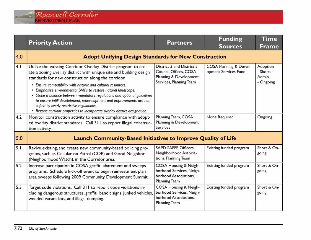
Roosevelt CorridorREinVEstMEnt PLan
7:72 City of San Antonio
Priority Action Partners Funding Sources
Time.Frame
4.0 Adopt Unifying Design Standards for New Construction
4.1 Utilize the existing Corridor overlay district program to cre-ate a zoning overlay district with unique site and building design standards for new construction along the corridor.
Ensure compatibility with historic and cultural resources. Emphasize environmental BMPs to restore natural landscape. Strike a balance between mandatory regulations and optional guidelines to ensure infill development, redevelopment and improvements are not stifled by overly restrictive regulations. Rezone corridor properties to incorporate overlay district designation.
•••
•
district 3 and district 5 Council Offices, COSA Planning & development services, Planning team
Cosa Planning & devel-opment services fund
adoption - short;admin.- ongoing
4.2 Monitor construction activity to ensure compliance with adopt-ed overlay district standards. Call 311 to report illegal construc-tion activity.
Planning team, Cosa Planning & development services
none Required ongoing
5.0 Launch Community-Based Initiatives to Improve Quality of Life
5.1 Revive existing, and create new, community-based policing pro-grams, such as Cellular on Patrol (CoP) and good neighbor (neighborhood Watch), in the Corridor area.
SAPD SAFFE Officers, neighborhood associa-tions, Planning team
Existing funded program short & on-going
5.2 Increase participation in COSA graffiti abatement and sweeps programs. schedule kick-off event to begin reinvestment plan area sweeps following 2009 Community development summit.
Cosa Housing & neigh-borhood services, neigh-borhood associations, Planning team
Existing funded program short & on-going
5.3 target code violations. Call 311 to report code violations in-cluding dangerous structures, graffiti, bandit signs, junked vehicles, weeded vacant lots, and illegal dumping.
Cosa Housing & neigh-borhood services, neigh-borhood associations, Planning team
Existing funded program short & on-going
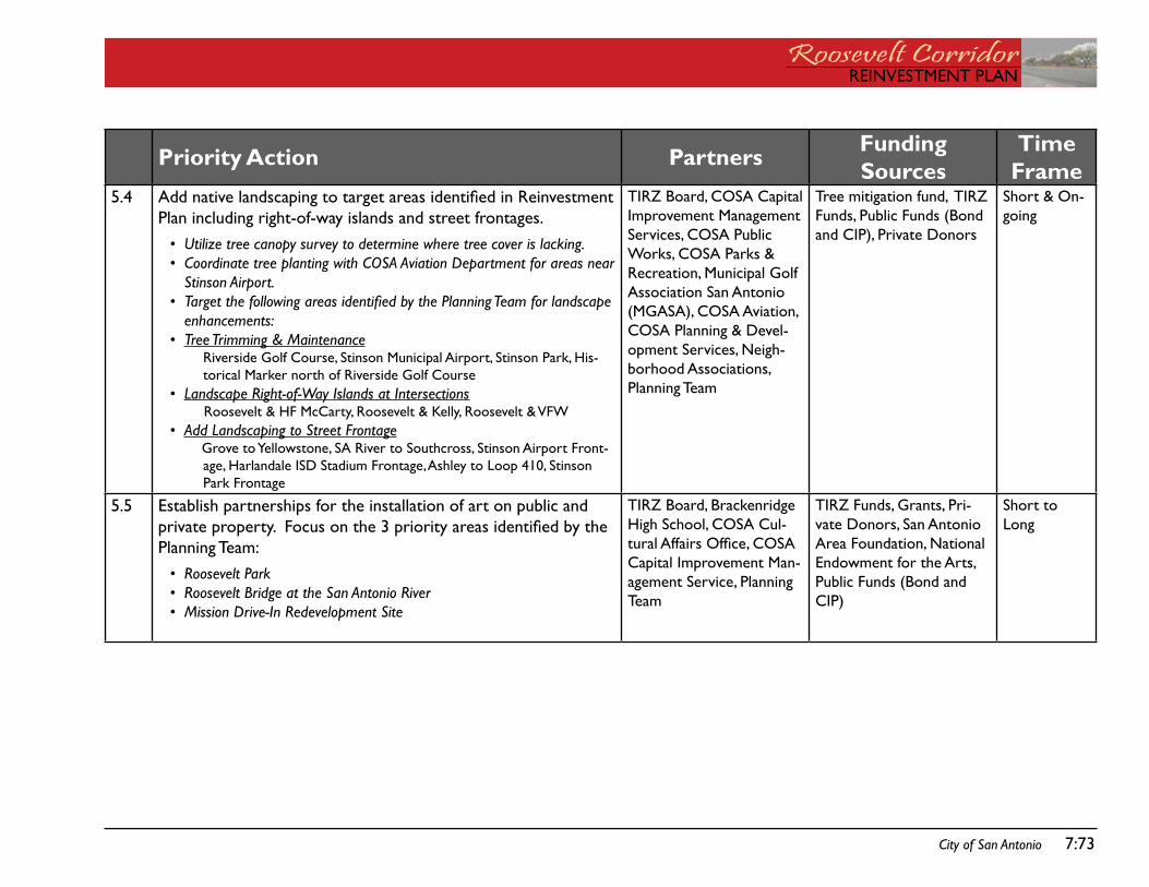
REinVEstMEnt PLanRoosevelt CorridorREinVEstMEnt PLan
City of San Antonio 7:73
Priority Action Partners Funding Sources
Time.Frame
5.4 Add native landscaping to target areas identified in Reinvestment Plan including right-of-way islands and street frontages.
Utilize tree canopy survey to determine where tree cover is lacking. Coordinate tree planting with COSA Aviation Department for areas near Stinson Airport.Target the following areas identified by the Planning Team for landscape enhancements:Tree Trimming & Maintenance
Riverside golf Course, stinson Municipal airport, stinson Park, His-torical Marker north of Riverside golf Course
Landscape Right-of-Way Islands at IntersectionsRoosevelt & Hf McCarty, Roosevelt & Kelly, Roosevelt & VfW
Add Landscaping to Street Frontagegrove to yellowstone, sa River to southcross, stinson airport front-age, Harlandale isd stadium frontage, ashley to Loop 410, stinson Park frontage
••
•
•
•
•
tiRZ Board, Cosa Capital improvement Management services, Cosa Public Works, Cosa Parks & Recreation, Municipal golf association san antonio (Mgasa), Cosa aviation, Cosa Planning & devel-opment services, neigh-borhood associations, Planning team
tree mitigation fund, tiRZ funds, Public funds (Bond and CiP), Private donors
short & on-going
5.5 Establish partnerships for the installation of art on public and private property. Focus on the 3 priority areas identified by the Planning team:
Roosevelt ParkRoosevelt Bridge at the San Antonio RiverMission Drive-In Redevelopment Site
•••
tiRZ Board, Brackenridge High school, Cosa Cul-tural Affairs Office, COSA Capital improvement Man-agement service, Planning team
tiRZ funds, grants, Pri-vate donors, san antonio area foundation, national Endowment for the arts, Public funds (Bond and CiP)
short to Long
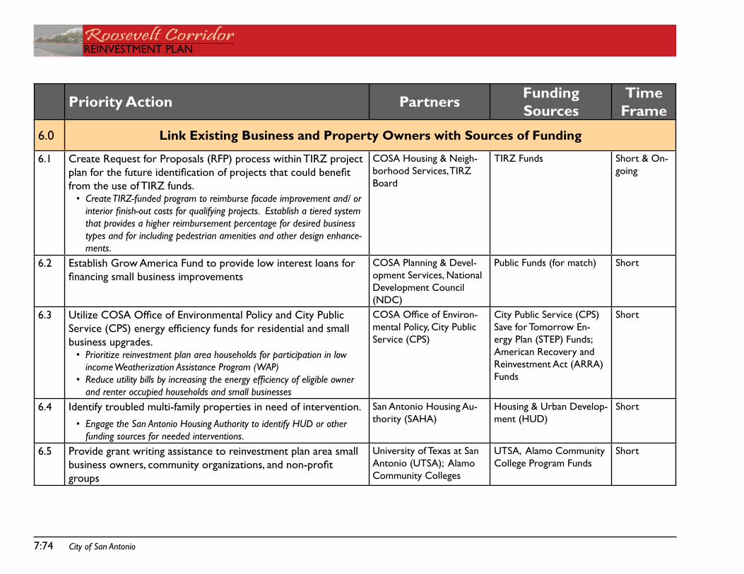
Roosevelt CorridorREinVEstMEnt PLan
7:74 City of San Antonio
Priority Action Partners Funding Sources
Time.Frame
6.0 Link Existing Business and Property Owners with Sources of Funding
6.1 Create Request for Proposals (RfP) process within tiRZ project plan for the future identification of projects that could benefit from the use of tiRZ funds.
Create TIRZ-funded program to reimburse facade improvement and/ or interior finish-out costs for qualifying projects. Establish a tiered system that provides a higher reimbursement percentage for desired business types and for including pedestrian amenities and other design enhance-ments.
•
Cosa Housing & neigh-borhood services, tiRZ Board
tiRZ funds short & on-going
6.2 Establish grow america fund to provide low interest loans for financing small business improvements
Cosa Planning & devel-opment services, national development Council (ndC)
Public funds (for match) short
6.3 Utilize COSA Office of Environmental Policy and City Public Service (CPS) energy efficiency funds for residential and small business upgrades.
Prioritize reinvestment plan area households for participation in low income Weatherization Assistance Program (WAP)Reduce utility bills by increasing the energy efficiency of eligible owner and renter occupied households and small businesses
•
•
COSA Office of Environ-mental Policy, City Public service (CPs)
City Public service (CPs) save for tomorrow En-ergy Plan (stEP) funds; american Recovery and Reinvestment act (aRRa) funds
short
6.4 identify troubled multi-family properties in need of intervention. Engage the San Antonio Housing Authority to identify HUD or other funding sources for needed interventions.
•
san antonio Housing au-thority (saHa)
Housing & Urban develop-ment (HUd)
short
6.5 Provide grant writing assistance to reinvestment plan area small business owners, community organizations, and non-profit groups
University of texas at san antonio (Utsa); alamo Community Colleges
Utsa, alamo Community College Program funds
short
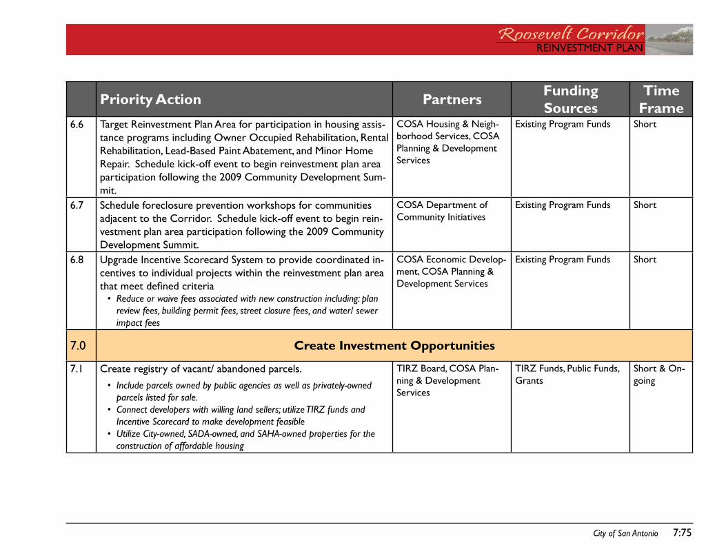
REinVEstMEnt PLanRoosevelt CorridorREinVEstMEnt PLan
City of San Antonio 7:75
Priority Action Partners Funding Sources
Time.Frame
6.6 target Reinvestment Plan area for participation in housing assis-tance programs including owner occupied Rehabilitation, Rental Rehabilitation, Lead-Based Paint abatement, and Minor Home Repair. schedule kick-off event to begin reinvestment plan area participation following the 2009 Community development sum-mit.
Cosa Housing & neigh-borhood services, Cosa Planning & development services
Existing Program funds short
6.7 schedule foreclosure prevention workshops for communities adjacent to the Corridor. schedule kick-off event to begin rein-vestment plan area participation following the 2009 Community development summit.
Cosa department of Community initiatives
Existing Program funds short
6.8 Upgrade incentive scorecard system to provide coordinated in-centives to individual projects within the reinvestment plan area that meet defined criteria
Reduce or waive fees associated with new construction including: plan review fees, building permit fees, street closure fees, and water/ sewer impact fees
•
Cosa Economic develop-ment, Cosa Planning & development services
Existing Program funds short
7.0 Create Investment Opportunities
7.1 Create registry of vacant/ abandoned parcels. Include parcels owned by public agencies as well as privately-owned parcels listed for sale. Connect developers with willing land sellers; utilize TIRZ funds and Incentive Scorecard to make development feasibleUtilize City-owned, SADA-owned, and SAHA-owned properties for the construction of affordable housing
•
•
•
tiRZ Board, Cosa Plan-ning & development services
tiRZ funds, Public funds, grants
short & on-going
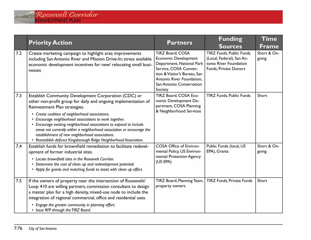
Roosevelt CorridorREinVEstMEnt PLan
7:76 City of San Antonio
Priority Action Partners Funding Sources
Time.Frame
7.2 Create marketing campaign to highlight area improvements including san antonio River and Mission drive-in; stress available economic development incentives for new/ relocating small busi-nesses
tiRZ Board, Cosa Economic development department, national Park service, Cosa Conven-tion & Visitor’s Bureau, san antonio River foundation, san antonio Conservation society
tiRZ funds, Public funds (Local, federal), san an-tonio River foundation funds, Private donors
short & on-going
7.3 Establish Community development Corporation (CdC) or other non-profit group for daily and ongoing implementation of Reinvestment Plan strategies.
Create coalition of neighborhood associations. Encourage neighborhood associations to work together. Encourage existing neighborhood associations to expand to include areas not currently within a neighborhood association or encourage the establishment of new neighborhood associations. Reestablish defunct Kingsborough Ridge Neighborhood Association.
•••
•
tiRZ Board, Cosa Eco-nomic development de-partment, Cosa Planning & neighborhood services
tiRZ funds, Public funds short
7.4 Establish funds for brownfield remediation to facilitate redevel-opment of former industrial sites.
Locate brownfield sites in the Roosevelt Corridor. Determine the cost of clean up and redevelopment potential. Apply for grants and matching funds to assist with clean up effort.
•••
COSA Office of Environ-mental Policy, Us Environ-mental Protection agency (Us EPa)
Public funds (local, Us EPa), grants
short & on-going
7.5 if the owners of property near the intersection of Roosevelt/ Loop 410 are willing partners, commission consultant to design a master plan for a high density, mixed-use node to include the integration of regional commercial, office and residential uses.
Engage the greater community in planning effort. Issue RFP through the TIRZ Board.
••
tiRZ Board, Planning team, property owners
tiRZ funds, Private funds short
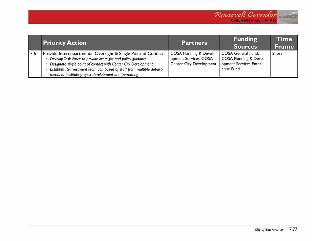
REinVEstMEnt PLanRoosevelt CorridorREinVEstMEnt PLan
City of San Antonio 7:77
Priority Action Partners Funding Sources
Time.Frame
7.6 Provide interdepartmental oversight & single Point of ContactDevelop Task Force to provide oversight and policy guidanceDesignate single point of contact with Center City DevelopmentEstablish Reinvestment Team composed of staff from multiple depart-ments to facilitate project development and permitting
•••
Cosa Planning & devel-opment services, Cosa Center City development
Cosa general fund, Cosa Planning & devel-opment services Enter-prise fund
short

Roosevelt CorridorREinVEstMEnt PLan
7:78 City of San Antonio

REinVEstMEnt PLanRoosevelt CorridorREinVEstMEnt PLan
oVERLay dEsign standaRdsaPPEndiX i:

Roosevelt CorridorREinVEstMEnt PLan
this page intentionally left blank.
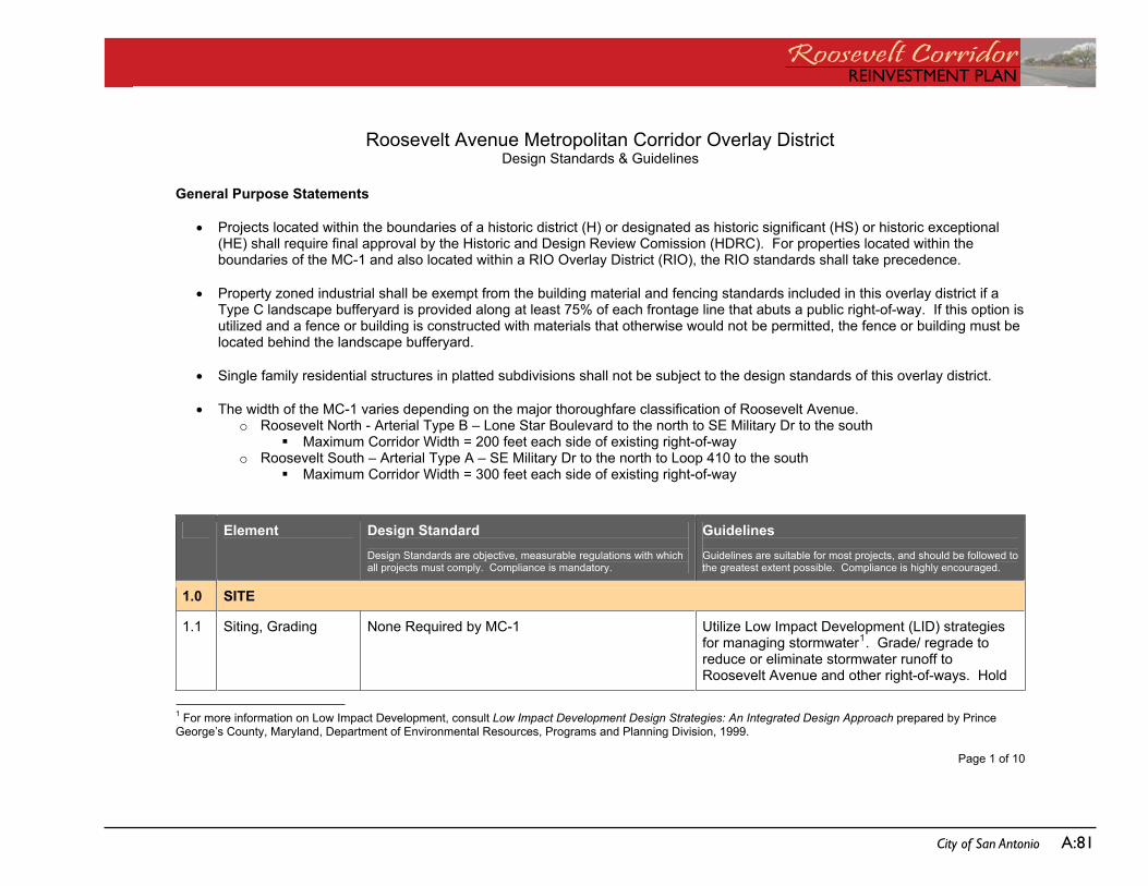
REinVEstMEnt PLanRoosevelt CorridorREinVEstMEnt PLan
City of San Antonio a:81
Roosevelt Avenue Metropolitan Corridor Overlay DistrictDesign Standards & Guidelines
Page 1 of 10
General Purpose Statements
Projects located within the boundaries of a historic district (H) or designated as historic significant (HS) or historic exceptional(HE) shall require final approval by the Historic and Design Review Comission (HDRC). For properties located within the boundaries of the MC-1 and also located within a RIO Overlay District (RIO), the RIO standards shall take precedence.
Property zoned industrial shall be exempt from the building material and fencing standards included in this overlay district if a Type C landscape bufferyard is provided along at least 75% of each frontage line that abuts a public right-of-way. If this option is utilized and a fence or building is constructed with materials that otherwise would not be permitted, the fence or building must be located behind the landscape bufferyard.
Single family residential structures in platted subdivisions shall not be subject to the design standards of this overlay district.
The width of the MC-1 varies depending on the major thoroughfare classification of Roosevelt Avenue. o Roosevelt North - Arterial Type B – Lone Star Boulevard to the north to SE Military Dr to the south
Maximum Corridor Width = 200 feet each side of existing right-of-way o Roosevelt South – Arterial Type A – SE Military Dr to the north to Loop 410 to the south
Maximum Corridor Width = 300 feet each side of existing right-of-way
Element Design Standard Design Standards are objective, measurable regulations with which all projects must comply. Compliance is mandatory.
Guidelines Guidelines are suitable for most projects, and should be followed to the greatest extent possible. Compliance is highly encouraged.
1.0 SITE
1.1 Siting, Grading None Required by MC-1 Utilize Low Impact Development (LID) strategies for managing stormwater1. Grade/ regrade to reduce or eliminate stormwater runoff to Roosevelt Avenue and other right-of-ways. Hold
1 For more information on Low Impact Development, consult Low Impact Development Design Strategies: An Integrated Design Approach prepared by Prince George’s County, Maryland, Department of Environmental Resources, Programs and Planning Division, 1999.
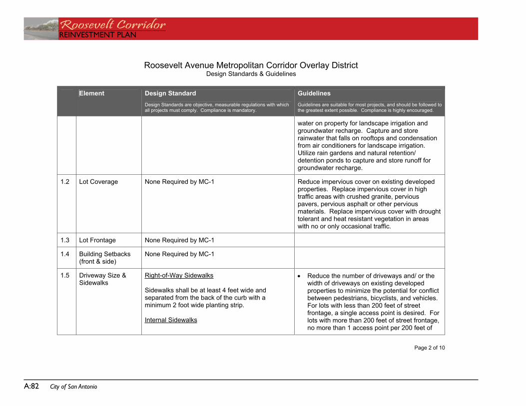
Roosevelt CorridorREinVEstMEnt PLan
a:82 City of San Antonio
Roosevelt Avenue Metropolitan Corridor Overlay DistrictDesign Standards & Guidelines
Page 2 of 10
Element Design Standard Design Standards are objective, measurable regulations with which all projects must comply. Compliance is mandatory.
Guidelines Guidelines are suitable for most projects, and should be followed to the greatest extent possible. Compliance is highly encouraged.
water on property for landscape irrigation and groundwater recharge. Capture and store rainwater that falls on rooftops and condensation from air conditioners for landscape irrigation.Utilize rain gardens and natural retention/ detention ponds to capture and store runoff for groundwater recharge.
1.2 Lot Coverage None Required by MC-1 Reduce impervious cover on existing developed properties. Replace impervious cover in high traffic areas with crushed granite, pervious pavers, pervious asphalt or other pervious materials. Replace impervious cover with drought tolerant and heat resistant vegetation in areas with no or only occasional traffic.
1.3 Lot Frontage None Required by MC-1
1.4 Building Setbacks (front & side)
None Required by MC-1
1.5 Driveway Size & Sidewalks
Right-of-Way Sidewalks
Sidewalks shall be at least 4 feet wide and separated from the back of the curb with a minimum 2 foot wide planting strip.
Internal Sidewalks
Reduce the number of driveways and/ or the width of driveways on existing developed properties to minimize the potential for conflict between pedestrians, bicyclists, and vehicles. For lots with less than 200 feet of street frontage, a single access point is desired. For lots with more than 200 feet of street frontage, no more than 1 access point per 200 feet of
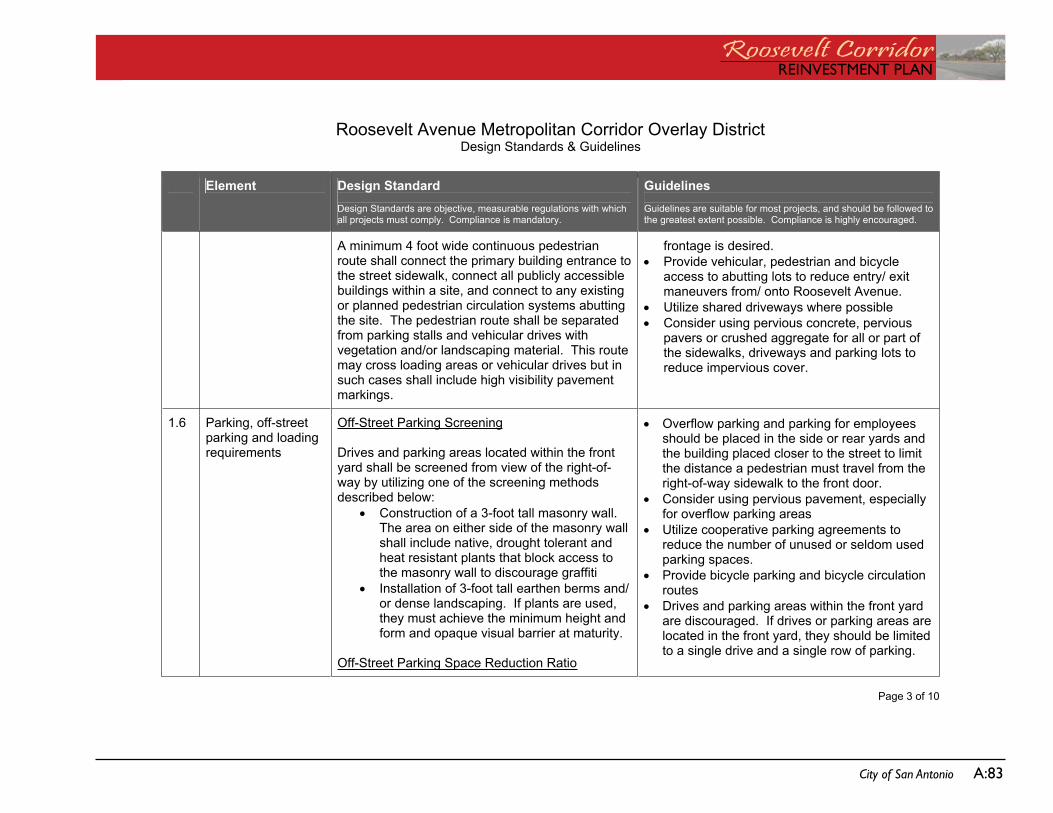
REinVEstMEnt PLanRoosevelt CorridorREinVEstMEnt PLan
City of San Antonio a:83
Roosevelt Avenue Metropolitan Corridor Overlay DistrictDesign Standards & Guidelines
Page 3 of 10
Element Design Standard Design Standards are objective, measurable regulations with which all projects must comply. Compliance is mandatory.
Guidelines Guidelines are suitable for most projects, and should be followed to the greatest extent possible. Compliance is highly encouraged.
A minimum 4 foot wide continuous pedestrian route shall connect the primary building entrance to the street sidewalk, connect all publicly accessible buildings within a site, and connect to any existing or planned pedestrian circulation systems abutting the site. The pedestrian route shall be separated from parking stalls and vehicular drives with vegetation and/or landscaping material. This route may cross loading areas or vehicular drives but in such cases shall include high visibility pavement markings.
frontage is desired. Provide vehicular, pedestrian and bicycle
access to abutting lots to reduce entry/ exit maneuvers from/ onto Roosevelt Avenue.
Utilize shared driveways where possible Consider using pervious concrete, pervious
pavers or crushed aggregate for all or part of the sidewalks, driveways and parking lots to reduce impervious cover.
1.6 Parking, off-street parking and loading requirements
Off-Street Parking Screening
Drives and parking areas located within the front yard shall be screened from view of the right-of-way by utilizing one of the screening methods described below:
Construction of a 3-foot tall masonry wall. The area on either side of the masonry wall shall include native, drought tolerant and heat resistant plants that block access to the masonry wall to discourage graffiti
Installation of 3-foot tall earthen berms and/ or dense landscaping. If plants are used, they must achieve the minimum height and form and opaque visual barrier at maturity.
Off-Street Parking Space Reduction Ratio
Overflow parking and parking for employees should be placed in the side or rear yards and the building placed closer to the street to limit the distance a pedestrian must travel from the right-of-way sidewalk to the front door.
Consider using pervious pavement, especially for overflow parking areas
Utilize cooperative parking agreements to reduce the number of unused or seldom used parking spaces.
Provide bicycle parking and bicycle circulation routes
Drives and parking areas within the front yard are discouraged. If drives or parking areas are located in the front yard, they should be limited to a single drive and a single row of parking.
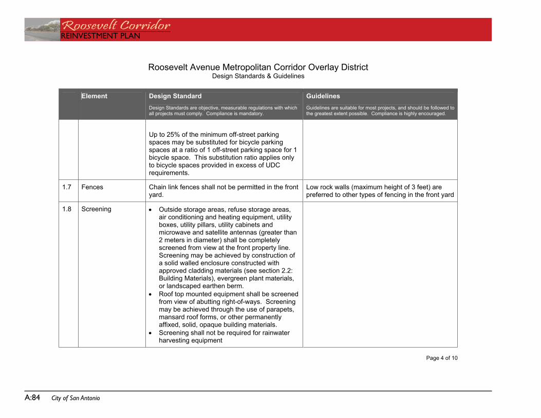
Roosevelt CorridorREinVEstMEnt PLan
a:84 City of San Antonio
Roosevelt Avenue Metropolitan Corridor Overlay DistrictDesign Standards & Guidelines
Page 4 of 10
Element Design Standard Design Standards are objective, measurable regulations with which all projects must comply. Compliance is mandatory.
Guidelines Guidelines are suitable for most projects, and should be followed to the greatest extent possible. Compliance is highly encouraged.
Up to 25% of the minimum off-street parking spaces may be substituted for bicycle parking spaces at a ratio of 1 off-street parking space for 1 bicycle space. This substitution ratio applies only to bicycle spaces provided in excess of UDC requirements.
1.7 Fences Chain link fences shall not be permitted in the front yard.
Low rock walls (maximum height of 3 feet) are preferred to other types of fencing in the front yard
1.8 Screening Outside storage areas, refuse storage areas, air conditioning and heating equipment, utility boxes, utility pillars, utility cabinets and microwave and satellite antennas (greater than 2 meters in diameter) shall be completely screened from view at the front property line.Screening may be achieved by construction of a solid walled enclosure constructed with approved cladding materials (see section 2.2: Building Materials), evergreen plant materials, or landscaped earthen berm.
Roof top mounted equipment shall be screened from view of abutting right-of-ways. Screening may be achieved through the use of parapets, mansard roof forms, or other permanently affixed, solid, opaque building materials.
Screening shall not be required for rainwater harvesting equipment
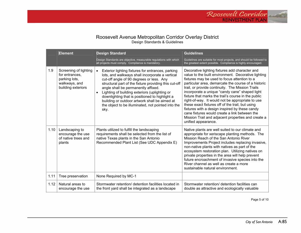
REinVEstMEnt PLanRoosevelt CorridorREinVEstMEnt PLan
City of San Antonio a:85
Roosevelt Avenue Metropolitan Corridor Overlay DistrictDesign Standards & Guidelines
Page 5 of 10
Element Design Standard Design Standards are objective, measurable regulations with which all projects must comply. Compliance is mandatory.
Guidelines Guidelines are suitable for most projects, and should be followed to the greatest extent possible. Compliance is highly encouraged.
1.9 Screening of lighting for entrances, parking lots, walkways, and building exteriors
Exterior lighting fixtures for entrances, parking lots, and walkways shall incorporate a vertical cut-off angle of 90 degrees or less. Any structural part of the fixture providing this cut-off angle shall be permanently affixed.
Lighting of building exteriors (uplighting or downlighting that is positioned to highlight a building or outdoor artwork shall be aimed at the object to be illuminated, not pointed into the sky.
Decorative lighting fixtures add character and value to the built environment. Decorative lighting fixtures may be used to focus attention to a particular area, demarcate the course of a historic trail, or provide continuity. The Mission Trails incorporate a unique “candy cane” shaped light fixture that marks the trail’s course in the public right-of-way. It would not be appropriate to use these exact fixtures off of the trail, but using fixtures with a design inspired by these candy cane fixtures would create a link between the Mission Trail and adjacent properties and create a unified appearance.
1.10 Landscaping to encourage the use of native trees and plants
Plants utilized to fulfill the landscaping requirements shall be selected from the list of native Texas plants in the San Antonio Recommended Plant List (See UDC Appendix E)
Native plants are well suited to our climate and appropriate for xeriscape planting methods. The Mission Reach of the San Antonio River Improvements Project includes replacing invasive, non-native plants with natives as part of the ecosystem restoration plan. Utilizing natives on private properties in the area will help prevent future encroachment of invasive species into the River channel as well as create a more sustainable natural environment.
1.11 Tree preservation None Required by MC-1
1.12 Natural areas to encourage the use
Stormwater retention/ detention facilities located in the front yard shall be integrated as a landscape
Stormwater retention/ detention facilities can double as attractive and ecologically valuable
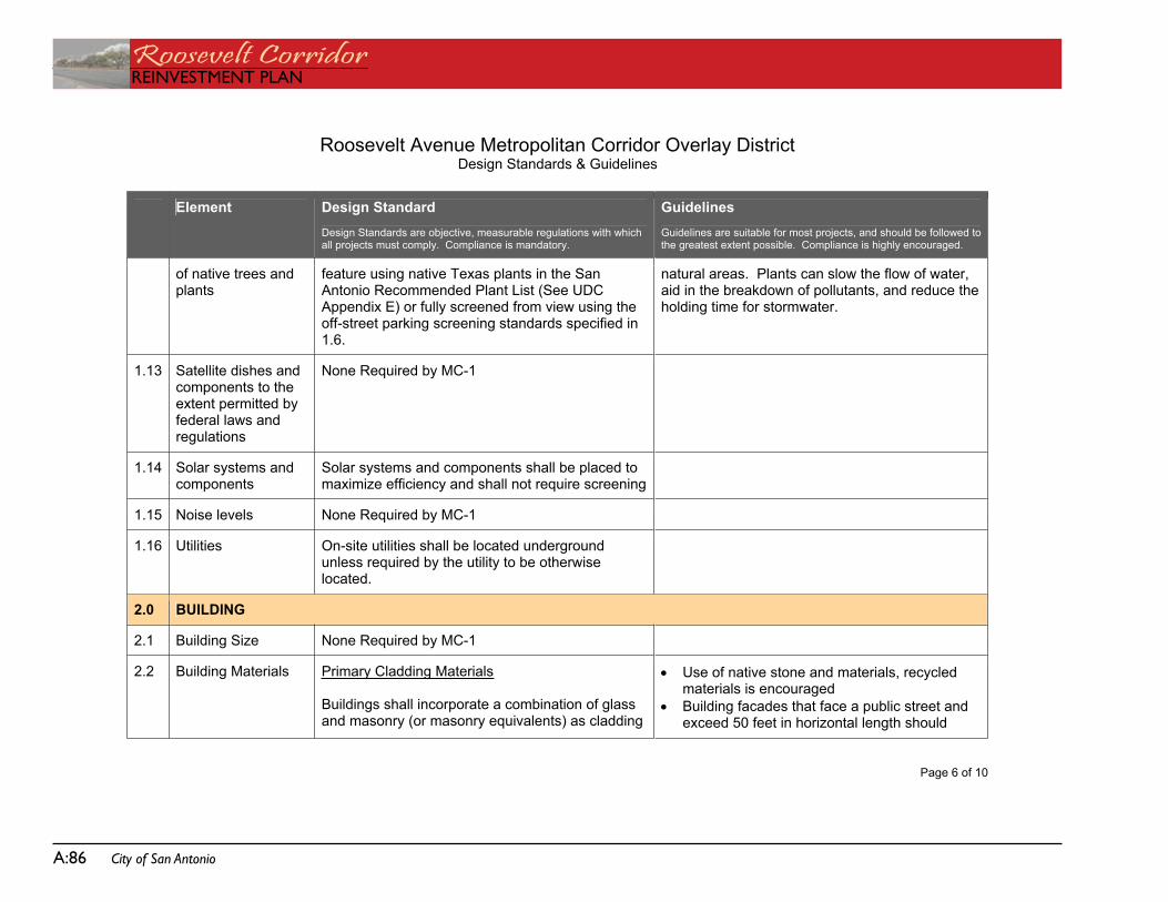
Roosevelt CorridorREinVEstMEnt PLan
a:86 City of San Antonio
Roosevelt Avenue Metropolitan Corridor Overlay DistrictDesign Standards & Guidelines
Page 6 of 10
Element Design Standard Design Standards are objective, measurable regulations with which all projects must comply. Compliance is mandatory.
Guidelines Guidelines are suitable for most projects, and should be followed to the greatest extent possible. Compliance is highly encouraged.
of native trees and plants
feature using native Texas plants in the San Antonio Recommended Plant List (See UDC Appendix E) or fully screened from view using the off-street parking screening standards specified in 1.6.
natural areas. Plants can slow the flow of water, aid in the breakdown of pollutants, and reduce the holding time for stormwater.
1.13 Satellite dishes and components to the extent permitted by federal laws and regulations
None Required by MC-1
1.14 Solar systems and components
Solar systems and components shall be placed to maximize efficiency and shall not require screening
1.15 Noise levels None Required by MC-1
1.16 Utilities On-site utilities shall be located underground unless required by the utility to be otherwise located.
2.0 BUILDING
2.1 Building Size None Required by MC-1
2.2 Building Materials Primary Cladding Materials
Buildings shall incorporate a combination of glass and masonry (or masonry equivalents) as cladding
Use of native stone and materials, recycled materials is encouraged
Building facades that face a public street and exceed 50 feet in horizontal length should
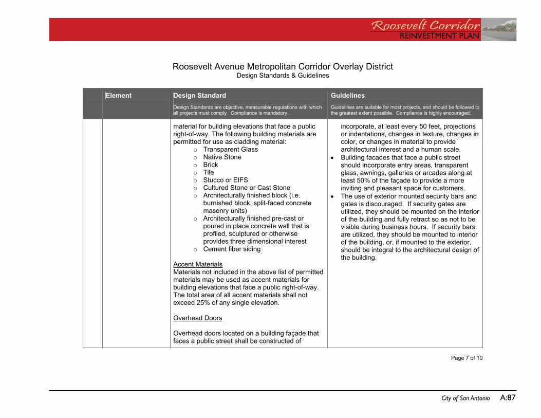
REinVEstMEnt PLanRoosevelt CorridorREinVEstMEnt PLan
City of San Antonio a:87
Roosevelt Avenue Metropolitan Corridor Overlay DistrictDesign Standards & Guidelines
Page 7 of 10
Element Design Standard Design Standards are objective, measurable regulations with which all projects must comply. Compliance is mandatory.
Guidelines Guidelines are suitable for most projects, and should be followed to the greatest extent possible. Compliance is highly encouraged.
material for building elevations that face a public right-of-way. The following building materials are permitted for use as cladding material:
o Transparent Glass o Native Stone o Brick o Tile o Stucco or EIFS o Cultured Stone or Cast Stone o Architecturally finished block (i.e.
burnished block, split-faced concrete masonry units)
o Architecturally finished pre-cast or poured in place concrete wall that is profiled, sculptured or otherwise provides three dimensional interest
o Cement fiber siding
Accent MaterialsMaterials not included in the above list of permitted materials may be used as accent materials for building elevations that face a public right-of-way.The total area of all accent materials shall not exceed 25% of any single elevation.
Overhead Doors
Overhead doors located on a building façade that faces a public street shall be constructed of
incorporate, at least every 50 feet, projections or indentations, changes in texture, changes in color, or changes in material to provide architectural interest and a human scale.
Building facades that face a public street should incorporate entry areas, transparent glass, awnings, galleries or arcades along at least 50% of the façade to provide a more inviting and pleasant space for customers.
The use of exterior mounted security bars and gates is discouraged. If security gates are utilized, they should be mounted on the interior of the building and fully retract so as not to be visible during business hours. If security bars are utilized, they should be mounted to interior of the building, or, if mounted to the exterior, should be integral to the architectural design of the building.
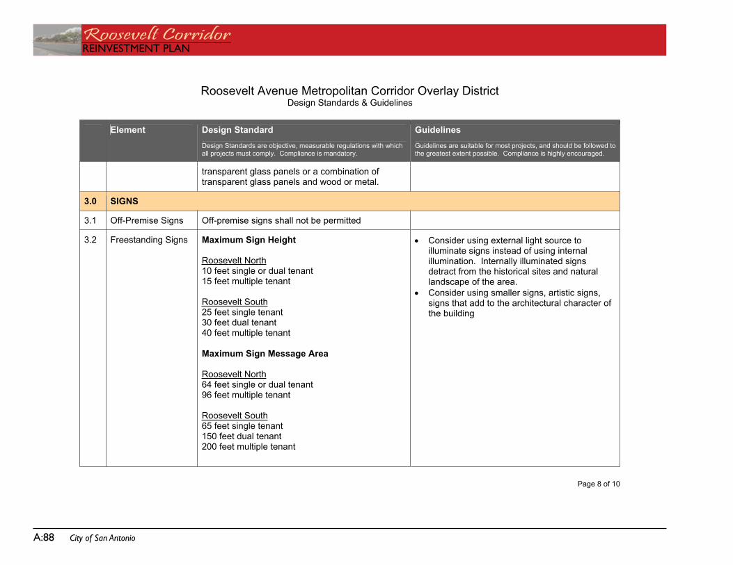
Roosevelt CorridorREinVEstMEnt PLan
a:88 City of San Antonio
Roosevelt Avenue Metropolitan Corridor Overlay DistrictDesign Standards & Guidelines
Page 8 of 10
Element Design Standard Design Standards are objective, measurable regulations with which all projects must comply. Compliance is mandatory.
Guidelines Guidelines are suitable for most projects, and should be followed to the greatest extent possible. Compliance is highly encouraged.
transparent glass panels or a combination of transparent glass panels and wood or metal.
3.0 SIGNS
3.1 Off-Premise Signs Off-premise signs shall not be permitted
3.2 Freestanding Signs Maximum Sign Height
Roosevelt North10 feet single or dual tenant 15 feet multiple tenant
Roosevelt South25 feet single tenant 30 feet dual tenant 40 feet multiple tenant
Maximum Sign Message Area
Roosevelt North64 feet single or dual tenant 96 feet multiple tenant
Roosevelt South65 feet single tenant 150 feet dual tenant 200 feet multiple tenant
Consider using external light source to illuminate signs instead of using internal illumination. Internally illuminated signs detract from the historical sites and natural landscape of the area.
Consider using smaller signs, artistic signs, signs that add to the architectural character of the building
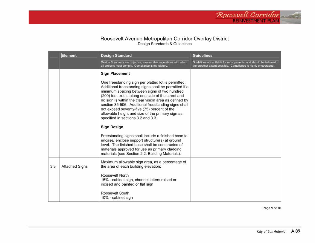
REinVEstMEnt PLanRoosevelt CorridorREinVEstMEnt PLan
City of San Antonio a:89
Roosevelt Avenue Metropolitan Corridor Overlay DistrictDesign Standards & Guidelines
Page 9 of 10
Element Design Standard Design Standards are objective, measurable regulations with which all projects must comply. Compliance is mandatory.
Guidelines Guidelines are suitable for most projects, and should be followed to the greatest extent possible. Compliance is highly encouraged.
Sign Placement
One freestanding sign per platted lot is permitted. Additional freestanding signs shall be permitted if a minimum spacing between signs of two hundred (200) feet exists along one side of the street and no sign is within the clear vision area as defined by section 35-506. Additional freestanding signs shall not exceed seventy-five (75) percent of the allowable height and size of the primary sign as specified in sections 3.2 and 3.3.
Sign Design
Freestanding signs shall include a finished base to encase/ enclose support structure(s) at ground level. The finished base shall be constructed of materials approved for use as primary cladding materials (see Section 2.2: Building Materials).
3.3 Attached Signs Maximum allowable sign area, as a percentage of the area of each building elevation:
Roosevelt North15% - cabinet sign, channel letters raised or incised and painted or flat sign
Roosevelt South10% - cabinet sign
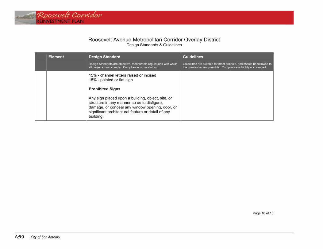
Roosevelt CorridorREinVEstMEnt PLan
a:90 City of San Antonio
Roosevelt Avenue Metropolitan Corridor Overlay DistrictDesign Standards & Guidelines
Page 10 of 10
Element Design Standard Design Standards are objective, measurable regulations with which all projects must comply. Compliance is mandatory.
Guidelines Guidelines are suitable for most projects, and should be followed to the greatest extent possible. Compliance is highly encouraged.
15% - channel letters raised or incised 15% - painted or flat sign
Prohibited Signs
Any sign placed upon a building, object, site, or structure in any manner so as to disfigure, damage, or conceal any window opening, door, or significant architectural feature or detail of any building.