Embed Size (px)
Citation preview
ASCE – Fall 2006 1
“Rehabilitation of an Existing Channel Dam
Engineering and Environmental Issues
Rio Vista Dam – San Marcos, Texas”
by
John N. Furlong, P.E., Project Manager
Halff Associates, Inc. 1201 North Bowser Road
Richardson, TX 75081
Laurie Anderson, P.E., City Engineer
City of San Marcos San Marcos, TX 78666
Wes Birdwell, P.E.,
Project Manager Halff Associates, Inc.
4030 West Braker Lane, Suite 450
Austin, Texas 78759-5356
Melani Howard Environmental Coordinator
City of San Marcos San Marcos, TX 78666
Lewis Yates, P.E.,
Special Projects Manager Fugro Consultants, Inc. 8613 Cross Park Drive
Austin, TX 78754
ASCE – Fall 2006 2
Rehabilitation of an Existing Channel Dam
Engineering and Environmental Issues
Rio Vista Dam – San Marcos, Texas
I. Introduction
A. Project Setting
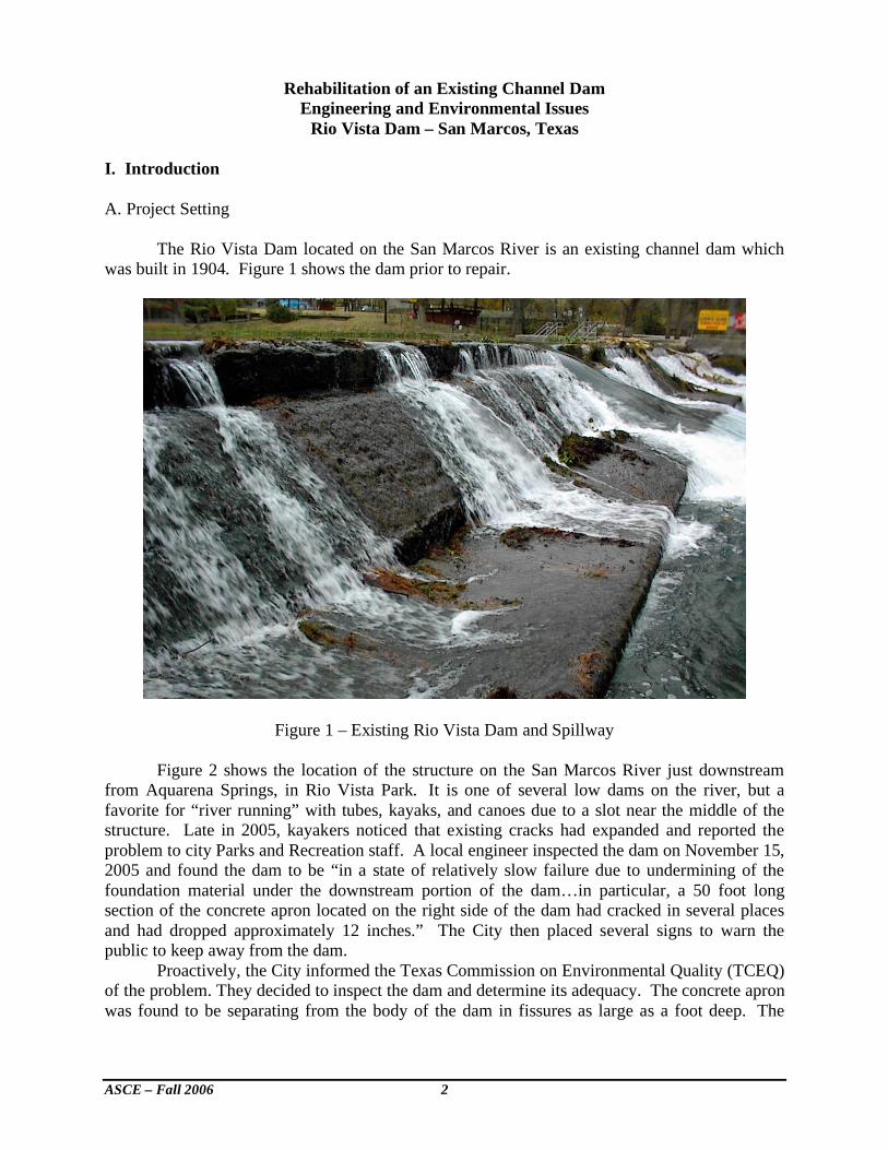
The Rio Vista Dam located on the San Marcos River is an existing channel dam which was built in 1904. Figure 1 shows the dam prior to repair.
Figure 1 – Existing Rio Vista Dam and Spillway Figure 2 shows the location of the structure on the San Marcos River just downstream from Aquarena Springs, in Rio Vista Park. It is one of several low dams on the river, but a favorite for “river running” with tubes, kayaks, and canoes due to a slot near the middle of the structure. Late in 2005, kayakers noticed that existing cracks had expanded and reported the problem to city Parks and Recreation staff. A local engineer inspected the dam on November 15, 2005 and found the dam to be “in a state of relatively slow failure due to undermining of the foundation material under the downstream portion of the dam…in particular, a 50 foot long section of the concrete apron located on the right side of the dam had cracked in several places and had dropped approximately 12 inches.” The City then placed several signs to warn the public to keep away from the dam. Proactively, the City informed the Texas Commission on Environmental Quality (TCEQ) of the problem. They decided to inspect the dam and determine its adequacy. The concrete apron was found to be separating from the body of the dam in fissures as large as a foot deep. The

ASCE – Fall 2006 3
TCEQ subsequently issued a letter stating safety issues and public welfare concerns. The City then decided to go forward with an emergency repair of the structure.
B. Project Understanding The existing Rio Vista Dam is about 10 feet high and 102 years old. It is a channel dam built with cedar and cypress posts in a log crib fashion which was later cover plated with concrete. The dam is located about 400 feet upstream from the Cheatham Drive bridge. The San Marcos River flows continuously at about 120-150 cubic feet per second over the dam. Four endangered and threatened species exist in this reach of the San Marcos River including native rice which grows above and below the dam structure. An old mill race exists on the left bank looking downstream. The dam site is protected by the San Marcos River Corridor Ordinance.
On December 14, 2005 the San Marcos City Council heard a presentation by Mr. Scott Shipley of Recreational Engineering and Planning, Inc. (REP). At the meeting, the City Council determined both to address the dam safety concerns and add recreational enhancements as proposed by REP. The council further determined to finish the project this spring and re-open the area by May 31, 2006. The city selected Halff Associates, Inc. to work with its Engineering and Parks and Recreation departments to address dam safety and right bank concerns. The City retained REP to address in-stream improvements. Fugro Consultants was retained to assist with geotechnical concerns.
Figure 2 – Location of Rio Vista Dam
Rio Vista
dam
ASCE – Fall 2006 4
Due to the location of the dam and its park setting, the general public placed great value on this structure. The City of San Marcos sees this area as a valuable economic asset to the community. Any construction activity to repair the structure would have to occur before the height of the tourist season beginning on Memorial Day and lasting through the summer months. This timing issue placed a great emphasis on scheduling the repair to occur prior to May 26th 2006. This date was a “drop dead” date for project completion.
Previous inspections of the dam were conducted by: 1) the State of Texas in 1982 and 2005, 2) the City by Freese & Nichols, Inc. in 1996 and 1999, and 3) TCEQ by R.J. Brandes, Inc. in November, 2005. The latest inspection letter to the City of San Marcos from TCEQ prompted the City staff to convene an initial project meeting on January 10, 2006 at which City staff, REP, Halff Associates, Fugro and other regulatory agencies were present. This meeting helped determine what course of action should be taken to repair the dam, what the repair would look like, and to some degree how much time and money would be involved for the repair to occur.
C. Project Approach
Several dam safety issues addressed in the design included: • Stabilizing the existing dam by grouting the interior mass and constructing a new buttress
section adjacent to and downstream of the existing structure • Removal of part of the right abutment which had failed • Addition of two downstream drop structures to reduce turbulence and velocities • Laying back the right abutment to provide better public access. • Diversion during construction of river flow • Protection of threatened or endangered species
Several state and federal agencies had permitting issues to be addressed. The agency and
their area of concern is summarized below:
• Texas Commission on Environmental Quality – Dam Safety Issues and NPDES permit.
The TCEQ’s dam safety unit has responsibility for oversight of dam safety issues. Design and construction issues with regard to dam safety will be reviewed by their staff. The state of Texas now reviews construction plans for Storm Water Pollution Prevention Plans through the National Pollution Discharge Elimination System (NPDES) permit process. This process requires the contractor to notify the TCEQ 24 hours in advance of the start of construction with a Notice of Intent and further requires that a SWPPP be submitted for review as construction proceeds.
• U.S. Army Corps of Engineers (USACE) 404 Permit – The USACE has responsibility for reviewing any instream activity which may impact waters of the United States. The San Marcos River qualifies as a “water of the United States.” This work activity falls under Section 3 of the USACE 404 permit process. Out of stream work activity, i.e., along the streambank, is covered by a Nationwide Section 27 permit under the 404 permit process. The USACE would review any work activity which impacts the streambank and abutments along the San Marcos River.
• U.S. Fish & Wildlife (USF&W) Department – Threatened and Endangered Species Act - The USF&W has responsibility for preservation of any threatened and endangered species in the construction area. Two known species are the native rice and fountain darter which reside in the San Marcos River. City of San Marcos staff are working
ASCE – Fall 2006 5
closely with the USF&W to assure adequate protection of the these two species and in the event of any disruption to the native rice area, it is our understanding that environmental groups are ready to transplant the rice to another water course for protection.
• Texas Parks & Wildlife Department – Sand & Gravel Permit – TP&W requires the contractor to obtain a sand & gravel permit since there will be some disruption the beds and banks of the San Marcos River. The City of San Marcos will work closely with the TP&W to assure that there is minimal disruption in the work area.
• Archeological Investigation – The staff at Texas State University has been requested to be present when the right bank area is cleared to check for any items of archeological significance.
All permits were obtained on an emergency basis due to the threat to public safety as a
result of potential dam failure. As much information as possible was submitted to all permitting agencies including maps, drawings, project description, best management practices designs, monitoring protocol, and site assessment. Emergency permits were issued with the majority of the paperwork to be accomplished after project completion. Weekly project status reports were submitted by the City to all permitting agencies. Interim issues such as intervals of turbid water, and concerns about the wild-rice were immediately addressed by the City.
To avoid or minimize take of the two endangered species at this site (Texas wild-rice and fountain darter), protective barriers were placed immediately upstream of the wild-rice stands to keep construction activity away and to maintain a pool of water for the plants during site dewatering. As the area was dewatered, City of San Marcos, Texas Parks and Wildlife, and US Fish and Wildlife staff removed biota and released them upstream of the dewatered area. US Fish and Wildlife also ran transects to establish a count of fountain darters in the area of impact. Take numbers will be based on these population samples. City staff worked from sunrise to sunset capturing and releasing the wide diversity of biota in the dewatered area.
The site was continually pumped to keep it relatively free of water. A detention pond was built to contain the pump discharge long enough for sediment to settle out before releasing this water back into the river.
Figure 3 – City and US Fish & Wildlife staff seining the San Marcos River for fountain darters.
ASCE – Fall 2006 6
City of San Marcos staff assumed responsibility for permit compliance for most of the oversight agencies mentioned above. II. Project Design/Construction Challenges
REP addressed instream improvements for the Rio Vista dam in their report, “Design
Report for the Rio Vista Dam Restoration Project”. Halff Associates addressed right bank improvements and hydrology and hydraulic issues in a report entitled, “Rio Vista Dam Rehabilitation – Preliminary Engineering Report”. Scheduling and cost challenges were addressed by the design team and the two contractors hired to assist with the design build challenges. Unique problems and issues were encountered during the design/construction process for the Rio Vista Renovation project. The manner in which these problems and issues were resolved is described below. A. Instream Channel Improvements
Prior to initiating design and construction, Fugro Consultants performed a geotechnical investigation to assess the site geology and subsurface conditions, and provide geotechnical design and construction recommendations. Core borings were drilled at each abutment of the dam revealing a stratigraphy of about 15 feet of alluvial soils overlying the Pecan Gap Chalk “bedrock” formation. This formation provided an excellent cutoff medium at a relatively shallow depth for reducing future erosion, scour, and undermining of the instream repair and improvements. Early in the design process, the decision was made to leave the existing dam in-place and construct an overlay/ buttress section to stabilize the structure.
The instream repair and enhancement features included the following:
1. Grouting to fill voids and strengthen the existing dam and fill in undermined areas with grout, rock boulders, and concrete. Because of the unknown condition of the interior of the dam, grouting was pumped under gravity or very low pressure head.
2. Cover the downstream face and apron of the existing dam with natural large rock boulders grouted in place. A buttress section of similar grouted rock boulders was added at the downstream toe of the old dam and keyed into the bedrock. This buttress section increased the overturning and sliding stability of the combined structure by adding mass and passive resistance to the downstream toe.
3. Construction of two new dam/drop structures about 100 feet and 180 feet downstream of the existing dam. These structures were constructed using the large, grouted rock boulders with a toe key extending into bedrock. The new structures increased the stability, albeit slightly, of the existing dam by increasing the tailwater elevation.
4. Construction of erosion protection rock boulders along the right and left banks between each of the dams.
One of the more interesting aspects of this project was the use of the large grouted rock
boulders as the primary construction material. The rock boulders consisted of natural limestone
blocks with lengths of about 3 to 5 feet and thickness of about 1 to 2 feet. The limestone was
obtained from a quarry near Johnson City, Texas and was chosen mainly for aesthetic appeal and
durability. The finished product resembles a Texas hill country stream cascading over a stair
ASCE – Fall 2006 7
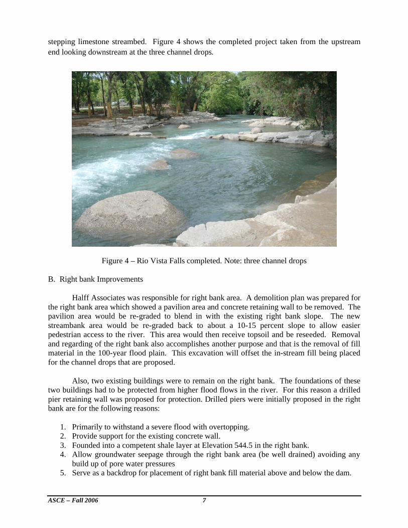
stepping limestone streambed. Figure 4 shows the completed project taken from the upstream
end looking downstream at the three channel drops.
Figure 4 – Rio Vista Falls completed. Note: three channel drops B. Right bank Improvements
Halff Associates was responsible for right bank area. A demolition plan was prepared for the right bank area which showed a pavilion area and concrete retaining wall to be removed. The pavilion area would be re-graded to blend in with the existing right bank slope. The new streambank area would be re-graded back to about a 10-15 percent slope to allow easier pedestrian access to the river. This area would then receive topsoil and be reseeded. Removal and regarding of the right bank also accomplishes another purpose and that is the removal of fill material in the 100-year flood plain. This excavation will offset the in-stream fill being placed for the channel drops that are proposed.
Also, two existing buildings were to remain on the right bank. The foundations of these two buildings had to be protected from higher flood flows in the river. For this reason a drilled pier retaining wall was proposed for protection. Drilled piers were initially proposed in the right bank are for the following reasons:
1. Primarily to withstand a severe flood with overtopping. 2. Provide support for the existing concrete wall. 3. Founded into a competent shale layer at Elevation 544.5 in the right bank. 4. Allow groundwater seepage through the right bank area (be well drained) avoiding any
build up of pore water pressures 5. Serve as a backdrop for placement of right bank fill material above and below the dam.
ASCE – Fall 2006 8
6. Eliminate the use of a cantilevered wall with footing which might damage some trees the City of San Marcos wanted to save.
A new wall was proposed which would be faced with a mortared rock and a boulder facade to match the in-stream channel dams and provide streambank protection. Thankfully, after construction began, a hold was placed on the wall construction. It was later discovered during the demolition process in the right bank area that a buried retaining wall already existed. This was left in place and now acts to protect the park structures.
Upstream of the existing dam structure, an area of concrete paving on the right bank appeared to be undercut to some extent. Placement of boulders, beneath the slab along the right bank with new grout was proposed to stabilize the bank and provide an adequate “key” against which to start a new bank slope after removal of the concrete.
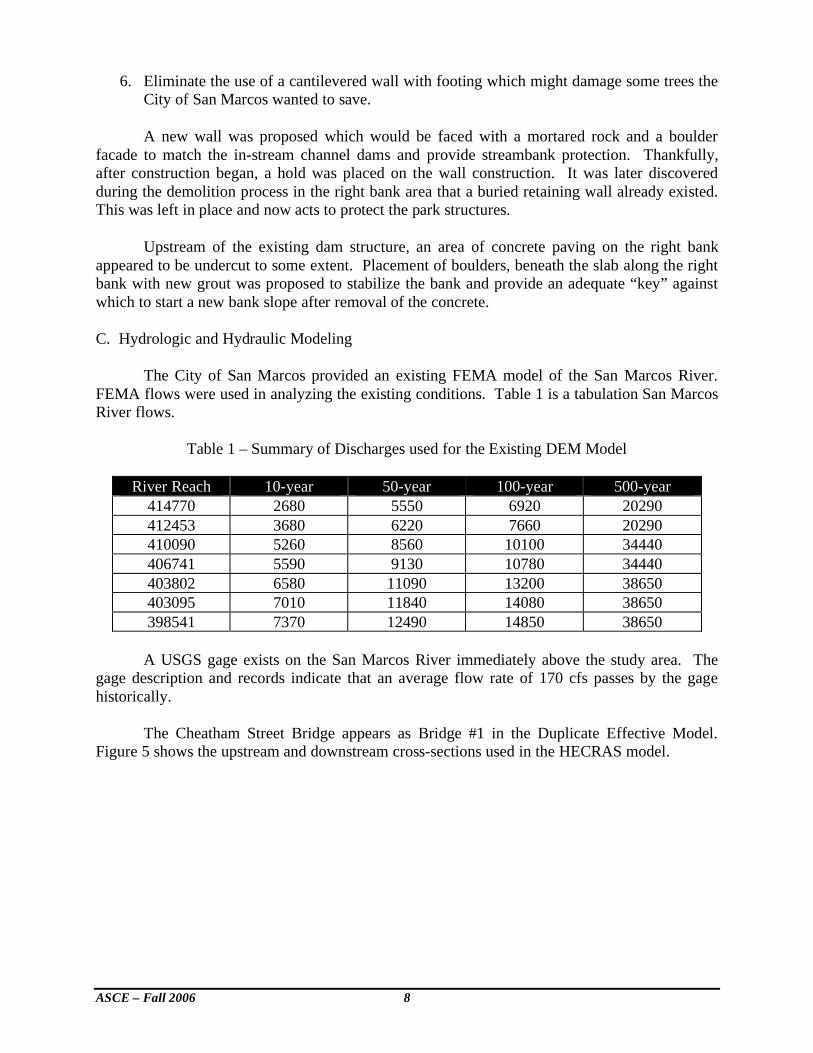
C. Hydrologic and Hydraulic Modeling The City of San Marcos provided an existing FEMA model of the San Marcos River. FEMA flows were used in analyzing the existing conditions. Table 1 is a tabulation San Marcos River flows.
Table 1 – Summary of Discharges used for the Existing DEM Model
River Reach 10-year 50-year 100-year 500-year
414770 2680 5550 6920 20290
412453 3680 6220 7660 20290
410090 5260 8560 10100 34440
406741 5590 9130 10780 34440
403802 6580 11090 13200 38650
403095 7010 11840 14080 38650
398541 7370 12490 14850 38650
A USGS gage exists on the San Marcos River immediately above the study area. The
gage description and records indicate that an average flow rate of 170 cfs passes by the gage historically.
The Cheatham Street Bridge appears as Bridge #1 in the Duplicate Effective Model.
Figure 5 shows the upstream and downstream cross-sections used in the HECRAS model.
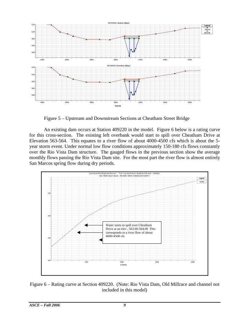
ASCE – Fall 2006 9
4400 4600 4800 5000 5200 5400 5600
555
560
565
570
575RS=408281 Upstream (Bridge)
Legend
Ground
Bank Sta
4400 4600 4800 5000 5200 5400 5600
555
560
565
570
575RS=408281 Downstream (Bridge)
Station (ft)
Figure 5 – Upstream and Downstream Sections at Cheatham Street Bridge An existing dam occurs at Station 409220 in the model. Figure 6 below is a rating curve
for this cross-section. The existing left overbank would start to spill over Cheatham Drive at Elevation 563-564. This equates to a river flow of about 4000-4500 cfs which is about the 5-year storm event. Under normal low flow conditions approximately 150-180 cfs flows constantly over the Rio Vista Dam structure. The gauged flows in the previous section show the average monthly flows passing the Rio Vista Dam site. For the most part the river flow is almost entirely San Marcos spring flow during dry periods.
5000 10000 15000 20000555
560
565
570
San M arcos River (Duplicate Effe ctive ) Plan : Im p orte d Plan 01 (Duplicate Effe ctive) 1/24/200 6
River = RIVER-1 Reach = Reach-1 RS = 409220 SMR-49 CHANNEL DAM T.O.D.=557.9
Q Total (cfs)
Legend
W.S. Elev
Figure 6 – Rating curve at Section 409220. (Note: Rio Vista Dam, Old Millrace and channel not included in this model)
Water starts to spill over Cheatham Drive at an elev.. 563.00-564.00 This corresponds to a river flow of about 4000-4500 cfs
ASCE – Fall 2006 10
2. Duplicate Effective Model with Rio Vista Dam (without project)
The Rio Vista Dam was in the Duplicate Effective Model, but not located in the right place. The DEM was corrected and run as a separate model. This became the base model against which proposed condition (with project) models were compared to. Summary tables of the DEM with Rio Vista Dam were determined.
3. Proposed Model (with project) The proposed model developed for this report includes the three drop structures proposed for the Rio Vista Dam reach and laying back of the right abutment area. Table 1 below summarizes the drop structures, crest elevation and subsequent drop in depth. The pool elevations and design were provided by Recreational Engineering and Planning, Inc. (REP), One of the City’s proposed requirements was to maintain the existing pool level at Rio Vista dam due to environmental concerns. Field surveys from Bryn Associates were provided by the City of San Marcos.
Table 2 – Proposed Drop Structure Elevations for Rio Vista Dam Reach
River Section Drop Structure Crest Elevation Height of Drop
408678 1 560.00 -
408660 2 556.00 3.0-4.0
408480 3 554.00 2.0 Pool Elev. Below Str. 3 552.00 2.0
Hydraulic constraints were analyzed through the reach to see what changes occurred for a full range of flood events. Reasons for this analysis were to address several concerns from a regulatory and operational standpoint. These are:
• FEMA requirements calling for no rise in the 100-year flood level in the regulatory floodway. Also, no significant loss of valley storage in the 100 and 500 year floodplains.
• The City of San Marcos is concerned about the effects of all storm events including the 10, 50, 100, and 500-year storm events.
• The Texas Commission on Environmental Quality is concerned about the right bank stabilization for dam safety reasons.
• To offset any fill material placed in the river, some right bank material is being removed from the 100-year flood plain. The amount of fill being placed in the river is less than 1000 cubic yards. The amount of fill material being taken out of the right bank is also about 1000 cubic yards.
• The U.S. Fish and Wildlife and Texas Parks & Recreation Department is concerned with threatened and endangered species like the Native rice growth areas and fountain darter fish.
• From an operational and construction standpoint the contractor is interested in what river level to safely build the cofferdam to for the Phased construction of the project
ASCE – Fall 2006 11
• The constricted flows during construction will naturally cause increase hydraulic forces on the existing structure. The rise of the river level due to a constricted channel were examined to see what additional forces might be impacting the structure.
Modeling constraints included shape files which were incomplete or did not show all the
cross-sections used in the original HEC-2 models for the San Marcos River. As stated before the FEMA discharges were used for the 10, 50, 100, and 500-year flood events. Channel n-values of 0.035 and overbank n-values of 0.070 were used for both the without and with project models. As can be seen from Table 2 the impact of the three low flow channel dams is insignificant. There is a maximum rise of 0.08’ with the three channel dams in place for the 100-year flood event.
a. Channel Drops in San Marcos River Basically the single channel drop (about 7 feet) at the Rio Vista Dam is being replaced by three smaller drops of 3’, 2’, and 2’. The riffle effects should be reduced for lower flows. The hydraulic model was run with lower flows of 50, 100, 200, 300, 500, and 1000 cfs to see what effect these flows had on the channel and overbank velocities. Channel velocities vary from 1-4 ft/sec for lower flows.
b. Care of Water During Construction Since the diversion of water during construction is a major component of the dam repair
it is necessary to address these concerns for Phase 1 and Phase 2 of the proposed construction activities. The City requested the contractor, KBR, to submit a diversion plan during construction for their review. The plan calls for the construction of 2-48” reinforced concrete pipes with headwalls built into the pool area of the Rio Vista dam and downstream exiting just upstream of the Cheatham Street Bridge. The proposed phased care of water is described as:
• Phase 1 would consist of a Port-a-Dam constructed upstream of the dam to block off a dry area to construct and intake headwall for temporary diversion. The diversion pipeline consisting of 2-48” pipes (200 cfs max) would then be built in the dry along the existing jogging trail.
• Phase 2 would consist of blocking off the entire stream to divert through the Phase 1 pipes and use the old millrace as a secondary overflow during excessive storm events. During the past two years the max. river flow has been 300 cfs. Phase 2 would also include a downstream coffer dam across the river to protect backwater from entering the project site.
• Environmental concerns for a native rice bed in the San Marcos River near the dam site would include a 12” pipe to divert some river flow to the native rice bed for water nourishment.
• The U.S. Fish & Wildlife expressed a concern about the velocity coming out of the diversion pipe just upstream of the Cheatham Street Bridge. Apparently, there is a sandbar immediately downstream of the Cheatham Street Bridge which is a good habitat for Fountain Darters. KBR felt that a proper deflection structure like concrete traffic barriers could be fashioned to work as adequate flow deflectors.
ASCE – Fall 2006 12
• Use of the old millrace channel and diversion structure will actually help out during construction by taking some of the river flow. To what degree this diversion can reduce river levels during construction was not analyzed in this study.
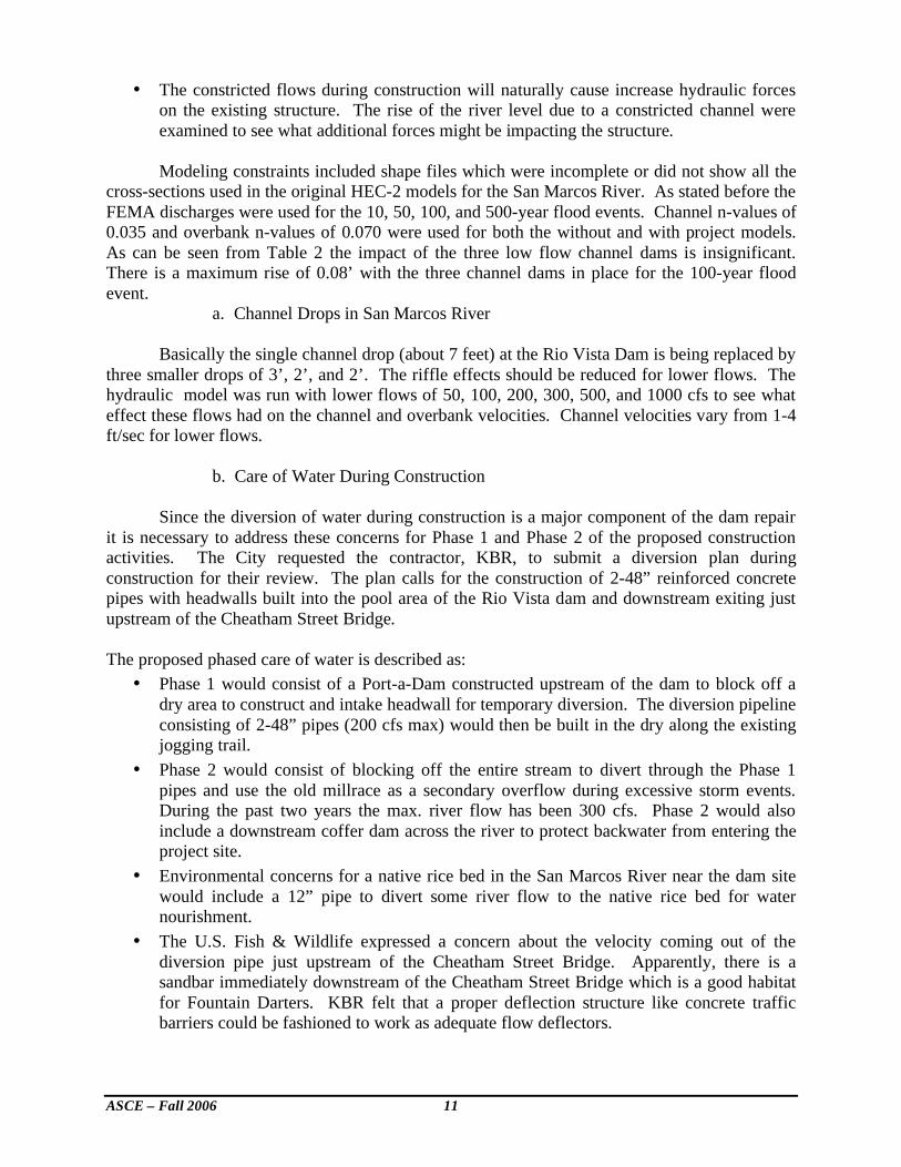
3. Use of Existing Millrace during construction
An existing millrace or secondary channel feeds off the existing pool above the Rio Vista Dam. Figure 7 shows this structure. The existing millrace consists of a three or four stop log structure which diverts flow away on the left bank of the river. This diversion channel was once used to mill grain in the San Marcos area.
Figure 7 – Looking at Millrace Channel from Cheatham Drive. (Note stop log structure)
This diversion channel enters a culvert under Cheatham Drive and from which an open concrete channel extends about 160’ in length. The channel terminates at an old Mill site. The flow from the old Mill site goes back into the San Marcos River downstream. The millrace system was not modeled. Once the San Marcos River overtops Cheatham Drive split flow ceases, and the millrace and river act hydraulically together. D. Scheduling Issues and Cost Due to the short construction window afforded by the City prior to the start of the summer recreational activities is was necessary to start contractor mobilization and material procurement at the earliest possible time. This necessitated working directly with the contractor from the outset of design and construction. Also, a construction limit line had to be designated which the contractor used throughout construction. There are some environmentally sensitive areas which have to be preserved and the very public nature of this project. As stated above the drop dead date for completion of construction was May 26th. This time constraint shortens the time available for analyzing different channel and dam configurations. Fortunately the City of San Marcos chose the concept plan given by REP in December, 2005 at a City Council meeting. This project when first proposed to the City Council was estimated to cost under $1,000,000. During the initial pre-design meetings the cost was estimated to be about
ASCE – Fall 2006 13
$1,300,000 for the proposed improvements. Once construction started and the exact nature of what the City of San Marcos wanted for the instream and rightbank improvements, and the extent of site preparation was determined, the initial cost rose to over $3,100,000. Money for this work effort came from the general revenue fund and other sources. III. Conclusions
Several notable conclusions were: • Schedule and time constraints will influence construction and design decisions due to the
short window allowed for actual work to occur. • Care of water is critical during the construction window. Any major flood event in the
San Marcos River would have set the project back beyond the May 25, 2006 deadline. • Working around the old Rio Vista dam will be difficult due to access issues and right
bank stability. • Use of the old millrace to supplement water diversion was a big help. • Excavation of right bank material and flattening the bank immediately above and below
the dam will allow for easier ingress/egress. • Construction of three smaller drop structures and grouting of the Rio Vista dam should
make the new drops and the historic dam safer for water recreation. • The construction of the three channel drops will cause a rise of 0.08’ in the water surface
elevation of the San Marcos River for the 100-year flood event. • Several environmental concerns were carefully worked out between City of San Marcos
staff and state and federal agencies. • Emergency management personnel and whitewater rescue workers were available during
all construction activities. • Use of drilled piers on the right bank was proposed to allow for the preservation of park
structures, and a solid foundation to support mortared rock along the right bank. • The 100-year water surface elevation in the Rio Vista dam area is approximately 571.00
from newly published FEMA maps in 2005. • The duplicate effective model (DEM) for the San Marcos River was corrected by locating
the Rio Vista dam in the right location. • A solid shale layer exists at elevation 544.5 in the right bank area. This layer was used as
a basis for a key trench in the right bank area. • The 100-Year floodplain line shown on FEMA FIRM Map Number 48209C0303F dated
September 2, 2005 for Hays County, Texas and Unincorporated Areas. Panel 393 of 495. The WSEL 571.00 shown for the 100-year flood event is influenced by backwater from the Blanco River and as such is the Regulatory BFE. The WSEL of 571.00 was shown as the floodplain on the construction drawings..
IV. References
1. Freese & Nichols 1996 and 1999 letter reports to the City of San Marcos about condition of Rio Vista Dam. 2. TCEQ letter from Warren Samuelson dated December 19, 2006 addressing concerns about the dam safety. 3. San Marcos Flood Insurance Study, Revised September 2, 2005, Federal Emergency Management Agency, FIS No. 48209CV001A, Hays County, Texas. 4. City of San Marcos website
ASCE – Fall 2006 14
5. San Marcos Quad sheets, U.S. Geological Survey, downloaded from Texas Natural Resource Information System. 6. Design of Small Dams, U.S. Dept. of Interior, Bureau of Reclamation, Revised Edition, 1977. 7. CRSI Handbook, by Concrete Reinforcing Steel Institute, 180 La Salle Street, Chicago, Illinois 60601, 2nd printing, 1981. 8. City of San Marcos Specifications, Engineering and Environmental Department, provided by City staff January, 2006. 9. HECRAS program 3.1.2., River Analysis System, Hydrologic Engineering Center, Davis California, April 2004. 10. San Marcos River Corridor Ordinance, City of San Marcos Code of Ordinances, www.municode.com January, 2006 11. Espey’s Duplicate Effective Model of San Marcos River – Reach B of Study. Obtained from FEMA for purposes of a Flood Protection Study in part funded through the Texas Water Development Board, January, 2006. 12. City of Austin Drainage Criteria Manual, and City of Austin Environmental Criteria Manual, latest edition up to 2005.