Embed Size (px)
Citation preview
Memorandum
Date: February 4, 2011
To: Dave Harlow, Director of the DRECP
Scott Flint, DRECP Program Manager, California Energy Commission
From: Paola Bernazzani, David Zippin, and Terah Donovan, ICF International
Subject: Desert Renewable Energy Conservation Plan (DRECP) Regulatory Framework Options
Introduction The purpose of this memo is to provide information that allows the renewable energy action team (REAT) to both structure the regulatory framework of the Desert Renewable Energy Conservation Plan (DRECP) and identify who the permit applicants will be. There are numerous options for structuring the Plan and its permits that meet DRECP goals and state and federal statutes. This memo introduces several regulatory framework options for meeting DRECP goals and evaluates the options against key parameters. The memo also provides examples of other conservation plans that take these approaches. The information in this memo is intended to support the discussion with the Stakeholder Committee. Direction from the REAT agencies on these two key decisions is needed by approximately March 2011 in order to meet the project schedule.
Regulatory Context
Background In November 2008, the California Governor’s Office issued an executive order requiring an increase in the percentage of electricity generated by renewable resources (#S‐14‐08). The order also directed state agencies to streamline regulatory processes and minimize environmental impacts associated with this development. The development of a DRECP was specifically mandated to address endangered‐species permitting in the Mojave and Colorado deserts where much of the energy development will occur.
The goal of the DRECP is to address the needs of listed and unlisted covered species and to streamline future permitting efforts for the development of renewable energy. This process is overseen by the REAT, consisting of the California Energy Commission (CEC), California Department of Fish and Game (DFG), Bureau of Land Management (BLM), and the U.S. Fish and Wildlife Service
DRECP Regulatory Framework Options Feb
Page 2 of 18
ruary 4, 2011
(USFWS) (referred to collectively as the REAT agencies). In addition, the process receives input from the DRECP Stakeholder Committee.
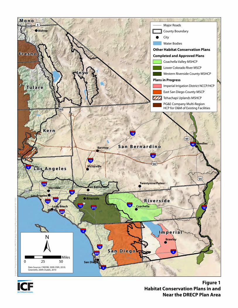
In order to meet its goals of protecting covered species and natural communities and promoting regulatory efficiency, the DRECP should evaluate its potential relationships with other existing and ongoing regional planning programs and environmental compliance efforts. The relationship of other Natural Community Conservation Plans/Habitat Conservation Plans (NCCPs/HCPs) and BLM’s California Desert Conservation Area (CDCA) Plan to the DRECP within its Plan Area are provided in Appendix A and displayed in Figure 1 and Table 1.
Regulatory Framework Options for DRECP The primary mission of the REAT agencies is to “streamline and expedite the permitting processes for renewable energy projects, while conserving endangered species and natural communities at the ecosystem scale,” as stated in the DRECP Planning Agreement (2010). There are several regulatory mechanisms available under the federal Endangered Species Act (ESA) and California Endangered Species Act (CESA) to fulfill this mission. The two primary mechanisms available for complying with the ESA and receiving incidental take authorization are as follows:
Section 7—development of a Biological Assessment and issuance of an incidental take statement in association with a Biological Opinion (projects with a federal nexus).
Section 10—development of a Habitat Conservation Plan and issuance of an incidental take permit (projects without a federal nexus only).
Under CESA, take of listed species may be authorized under the following:
California Fish and Game Code Section 2080.1—consistency determination for species listed under both the ESA and CESA.
California Fish and Game Code Section 2081(b)—incidental take permit for permit for state‐listed species only.
California Fish and Game Code Section 2835—development of an NCCP and issuance of permit under the Natural Community Conservation Planning Act (NCCPA).
Public Resources Code Section 25500 under the Warren‐Alquist Act—CEC certification of energy facilities in lieu of any permit required by the state or federal agency, including an incidental take permit.
Although these federal and state regulatory compliance mechanisms are available, some are inconsistent with the intent of the REAT agencies to prepare an HCP/NCCP as stated in the Planning Agreement. Furthermore, Governor Schwarzenegger’s Executive Order S‐14‐08 directs DFG to complete NCCPs to streamline compliance for renewable energy projects. Therefore, the regulatory framework options discussed in this memo do not consider permits under Section 2081(b) or Section 2080.1 (i.e., a consistency determination). Previously, we evaluated a “permit‐less” conservation strategy and the use of a regional mitigation bank. These options were rejected because they are inconsistent with the intent to prepare an NCCP.
DRECP Regulatory Framework Options Feb
Page 3 of 18
ruary 4, 2011
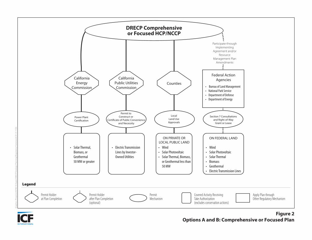
Within the HCP/NCCP regulatory framework, three options were identified: a comprehensive HCP/NCCP, a focused HCP/NCCP, and an umbrella HCP/NCCP, described below and illustrated in Figures 2 and 3. Key elements, including permit applicants, permit term, covered species, and schedule, are discussed below for each option.
These three options all include the development of an HCP/NCCP with a federal permit under Section 10 of the ESA and a state permit under Section 2835 of the NCCPA. An NCCP must meet a high standard for conservation including contributing to the recovery of covered species, protecting ecosystems, and conserving ecological processes. An HCP must meet five specific permit‐issuance criteria including minimizing and mitigating the project’s impact on covered species and assuring adequate funding for plan implementation, within the broader context of ESA’s purpose of conserving ecosystems for species.
The options developed for this memo aim to streamline projects with and without a federal nexus. Both federal and non‐federal projects would be made more efficient by drawing from standardized requirements set forth in the conservation strategy. Non‐federal projects covered by the plan and subject to the jurisdiction of the DRECP permit applicants would receive endangered‐species compliance under Section 10 of the ESA. Projects with a federal nexus would obtain endangered‐species compliance through the Section 7 consultation process. For all three options, the mechanism by which federal agencies participate is the same (see Figures 2 and 3). The relationship of the DRECP to federal actions and future Section 7 consultations is discussed under Relationship of DRECP to Federal Actions below.
Option A: Comprehensive HCP/NCCP A comprehensive HCP/NCCP provides the broadest, up‐front coverage of the proposed options. It includes a comprehensive species list, similar in scope to the list provided in the Planning Agreement. The comprehensive HCP/NCCP is also likely to address the widest range of covered activities associated with renewable energy development. Relative to Option B, the comprehensive HCP/NCCP provides greater protections for species, natural communities, and ecosystem processes, while affording the broadest coverage for renewable energy development. This approach requires the participation of many affected local, state, and federal agencies to prepare the plan and Implementing Agreement. The comprehensive HCP/NCCP mirrors the breadth and scope of the HCP/NCCP described in the Planning Agreement.
The comprehensive HCP/NCCP and focused HCP/NCCP (described below) have identical regulatory compliance structures (Figure 2) but differ in terms of their scale and scope. In both cases, there would be a finite number of permit holders at Plan completion. These permit holders would have the ability to extend take coverage to third‐party applicants, such as renewable‐energy companies, under their jurisdiction. At this time, only the CEC has committed to being a permit holder at Plan completion. The CEC could extend take authorization received through the DRECP to project applicants through power‐plant certification for solar‐thermal, biomass, or geothermal power plants 50 megawatts (MW) or greater.
Other potential permit holders at Plan completion include the CPUC and counties within the DRECP Plan Area. As permit holders under the Plan, the CPUC could extend take authorization to project applicants through a Permit to Construct or through a Certificate of Public Convenience and Necessity for electric transmission lines built and operated by investor‐owned utilities. Counties
DRECP Regulatory Framework Options Feb
Page 4 of 18
ruary 4, 2011
could extend take authorization to project applicants through local land use approvals on private or local public lands for solar thermal, biomass, or geothermal projects less than 50 MW or for a wind or solar photovoltaic project of any size (i.e., any renewable energy project not subject to CEC jurisdiction).
Option B: Focused HCP/NCCP This option is similar to the comprehensive HCP/NCCP (Figure 2), but the covered species and/or covered activities lists are more limited than those proposed in the Planning Agreement (2010) and in Options A and C. The DRECP Plan Area may also be smaller in a focused HCP/NCCP to target coverage and conservation on key covered activities and species.
The rationale for this approach is that a longer species list requires more work, and therefore more time and money is needed to prepare the Plan, conduct the impact analysis, ensure adequate conservation, and obtain approval. A longer species list also requires additional monitoring (and cost) during implementation. The species list can be narrowed using a variety of methods. In a simple approach, the list could be limited to federally or state‐listed species (i.e., those species for which take authorization is required now). A carefully selected, but smaller, species list can provide comparable conservation while reducing costs of implementation. If species become listed in the future, the Plan could be amended to add them. The species list could also be limited by conducting a risk analysis, which considers variables such as species status, likelihood of listing with and without Plan implementation, data availability, species endemism, species regional importance, likelihood of impacts resulting from covered activities, and potential effects of climate change on species viability. Only the species that are most likely to be both impacted by covered activities and listed under CESA or ESA during the permit term would be included as covered.
In a focused HCP/NCCP, covered activities could be limited by type (e.g., excluding small‐scale renewable energy projects) or by geographic area (e.g., defining energy‐resource zones with the highest potential for energy generation). While the focused HCP/NCCP reduces the time and effort required to prepare the Plan, it would also provide more limited coverage in terms of species, activities, or geography.
Option C: Umbrella HCP/NCCP An umbrella HCP/NCCP can provide the same broad coverage described above for the comprehensive HCP/NCCP in terms of species, plan area, and covered activities, or a narrower list of species and covered activities as described for Focused HCP/NCCP Option B. However, the umbrella HCP/NCCP would be structured differently. Option C would have only one permit holder at Plan completion, as of the date of this memo—the CEC. This option would allow additional entities to “opt in” after the plan is permitted (Figure 3). Future permit holders would join the plan by applying for an incidental take permit from USFWS and DFG, signing an Implementing Agreement, and receiving permit from USFWS and DFG which contains the permit conditions.
As described under Option A, the CEC would have the authority to extend take coverage to project applicants under their jurisdiction. The CPUC, state land managers (e.g., State Lands Commission, California Department of Transportation, California State Parks), counties, cities, special districts within the DRECP Plan Area, and renewable‐energy companies would have the ability to become
DRECP Regulatory Framework Options Feb
Page 5 of 18
ruary 4, 2011
permit holders during or after Plan completion by agreeing to implement the terms and conditions of the Plan. Once take authorization is received, it could be extended to project applicants under the permit holder’s respective jurisdictions.
Renewable‐energy companies would be able to receive take authorization through local or state permit holders, or they could opt‐in by applying for their own permit, signing their own implementing agreement and receiving their own permits. . This would provide flexibility and access for renewable‐energy companies whose projects fall outside the jurisdiction of the CEC, CPUC, or other permit holders.
Under this option, the DRECP would be written to anticipate participation of additional Permittees (i.e., besides the CEC) but would not rely upon them. In this way, the plan would be “scalable” so that, for example, the conservation strategy would grow as the number of Permittees and impacts grow. The plan would also need to stand alone in case the CEC remains the only permit holder.
The umbrella option can be beneficial when a plan covers a large area with many jurisdictions and agencies, each with different timelines and needs. Options A and B propose a single Implementing Agreement prepared by multiple jurisdictions with a common set of rules and procedures that all plan participants must follow. Getting approval from many diverse jurisdictions at the same time may be infeasible or impractical. Option C identifies pre‐determined obligations that future signatories would be required to follow to receive take authorization under their own permits. . Another advantage of the umbrella HCP/NCCP is that it allows each jurisdiction or land use agency to receive permits and implement the Plan when they are ready to participate. However, participation during Plan development ensures that permit applicants can influence the content and direction of the plan.
In a HCP/NCCP designed under the Option A or B scenarios, applicants who wish to join a plan after its adoption must prepare their own plan amendment, permit application ,NEPA document, and Implementing Agreement.. This process requires that all current permit holders adopt the amended plan. Under Option C, the process of adding a permittee is streamlined because future permittees were anticipated in the original plan. Under Option C, permittees that join later would submit their own permit application and Implementing Agreement to CDFG and USFWS, but they could potentially rely on or tier off the umbrella plan environmental impact statement (EIS) for their NEPA compliance. Depending on how the umbrella plan is designed, additional documentation may or may not be required. Because the umbrella plan anticipates future permittees, a formal amendment process with approval by all permit holders is not needed.
The umbrella HCP/NCCP approach has been used in several instances in southern California. In some cases the umbrella HCP/NCCP served as a conceptual conservation plan that required streamlined “subarea HCP/NCCPs” to be written and approved (e.g., San Diego North County Multiple Habitat Conservation Program). Subarea plans tier off of the umbrella HCP/NCCP. As a result, these subarea plans focus on certain aspects unique to each jurisdiction such as the implementation framework and funding strategy. Subarea plans may or may not be required using Option B, although if needed they will likely be streamlined.
In summary, the key factors that distinguish Option C from Options A and B are 1) one or few permit holders at plan adoption, 2) scalable design (e.g., allowable impacts and conservation), and 3) the ability for additional permittees to join later through a streamlined process that includes
DRECP Regulatory Framework Options Feb
Page 6 of 18
ruary 4, 2011
preparation of the subarea plan, or other document , permit application, and Implementing Agreement.
Key Issues Although the specific nature of the permits is not decided, an exploration of key issues will help inform the decision‐making process. Two key issues are discussed below: the identity of the permit applicants and the relationship of DRECP to projects with federal actions.
Identity of Permit Applicants One of the key decisions identified early in the planning process is who will hold the federal and state permits. Only a non‐federal entity is eligible to hold these permits because federal agencies must obtain their take authorization through Section 7 of the ESA, not Section 10. The relationship between the DRECP and federal agencies are discussion below in Relationship of DRECP to Federal Actions.
Only one entity, the CEC, is identified in the DRECP Planning Agreement as a likely permit holder. Othe ermits are as follows: r candidates to hold the DRECP state and federal p
the California Public Utilities Commission (CPUC),
Operators (ISO), the California Independent System
state land management agencies,
districts, and local governments and special
renewable energy companies.
Each of these potential permit holders for the Section 10 permits is discussed below and illustrated in Figures 2 and 3.
California Energy Commission
The CEC certifies energy generation facilities that are thermal power plants with a generating capacity of 50 MW or more, including auxiliary facilities. Thermal power plants under the jurisdiction of the CEC include concentrated solar power (i.e., solar thermal) facilities, biomass energy facilities, and geothermal energy facilities. The CEC also issues permits for project‐related substations and transmission lines between power plants under its jurisdiction.
As a DRECP permit applicant, the CEC would only be able to extend take authorization to covered activities under its jurisdiction. Therefore, wind energy projects, solar photovoltaic projects, solar‐thermal projects, or biomass energy projects under 50 MW would need take authorization through other permit holders. With respect to CESA permits, the CEC may issue an in‐lieu permit for take authorization under the Warren‐Alquist Act. (Whether the CECs permitting authority can be used to issue endangered species permits under the NCCPA has not been determined.)
DRECP Regulatory Framework Options February 4, 2011
Page 7 of 18
projects on their lands. The C
California Public Utilities Commission
The CPUC permits the construction and upgrading of power and transmission lines1 associated with renewable energy projects. The CPUC reviews permit applications from investor‐owned utilities (IOU)2 and approves IOU procurement contracts for electricity generated by renewable energy resources. The CPUC issues a Permit to Construct to an electric public utility for construction of facilities between 50 kilovolts (kV) and 200 kV or a Certificate of Public Convenience and Necessity (CPCN) for any facility greater than or equal to 200 kV. The CPUC also serves as the California Environmental Quality Act (CEQA) lead agency for these projects. If the CPUC was a DRECP permit holder, it could extend take authorization through its permit to power line and transmission line projects under its jurisdiction.
California Independent System Operator
The ISO is a non‐profit public benefit corporation charged with operating the majority of California’s high‐voltage wholesale power grid. Prior to permitting a transmission line, the ISO or other publically owned utility approves an electric transmission interconnection study to identify and address mitigation of adverse impacts on the electric grid. Although the California ISO has oversight over the electric transmission network in the state, they do not have regulatory authority over the construction of transmission lines (the CPUC has this authority). Furthermore, the California ISO has no oversight or regulatory authority over the construction of power generation facilities. Therefore, the California ISO is not a candidate for a DRECP permit holder.
Other State Agencies
Other state agencies with permit authority over DRECP covered activities could also be eligible to hold DRECP ESA and NCCPA permits. For example, the California Department of Conservation, Division of Oil, Gas, and Geothermal Resources, oversees development of exploratory wells for geothermal energy projects throughout the state. This state agency serves as the CEQA lead agency for the construction and operation of exploratory geothermal wells unless it delegates this authority to a county that has an adopted geothermal element in their general plan3.
State Land Management Agencies
Renewable energy projects proposed on lands owned by the state would need authorization from the state agency to construct and operate the project. Seven state agencies or state‐chartered conservancies own and manage land in the DRECP Plan Area. The three state agencies with the largest land holdings are discussed below. The four remaining entities (University of California Natural Reserve System, California Wildlife Conservation Board, and two state‐chartered conservancies) own less than 2,000 acres each and are not expected to propose renewable energy
EC is currently studying the potential for all state lands in California to 1 ” as The CPUC defines “power lines” as having a capacity of between 50 kV and 200 kV and “transmission lineshaving a capacity of greater than 200 kV. 2 California has three major investor‐owned electric utilities: The Pacific Gas and Electric Company (PG&E), S DG&E) and four smaller electric outhern California Edison (SCE), and San Diego Gas and Electric Company (Sutilities. 3 See ftp://ftp.consrv.ca.gov/pub/oil/laws/PRC02.pdf for more information.
DRECP Regulatory Framework Options Feb
Page 8 of 18
environmental review proce
ruary 4, 2011
support renewable energy projects. If found feasible, the state may encourage or propose such projects on state‐owned land in the DRECP Plan Area.
California State Lands Commission
The California State Lands Commission (SLC) has jurisdiction over electric‐generating power plants less than 50 MW, solar photo voltaic, and other non‐thermal power plants (e.g., wind) on lands owned by the SLC. The SLC owns an estimated 398,070 acres of land within the DRECP Plan Area, or approximately 1.6 % of the DRECP Plan Area. It is not known whether any renewable energy projects have been proposed to date on SLC lands. Although their land ownership is relatively small, their ownership pattern is scattered throughout much of the DRECP Plan Area in one‐square‐mile land holdings, primarily in San Bernardino, Riverside, and Imperial Counties. As a non‐federal entity, the SLC could hold permits under the DRECP and extend their take authorization to private applicants who build projects on SLC lands.
California Department of Parks and Recreation
The California Department of Parks and Recreation (CDPR) owns and manages 328,277 acres of land in the DRECP Plan Area (1.3%) in seven park units. Land ownership of the CDPR is spread throughout the DRECP Plan Area but is concentrated on its western boundary in Riverside and San Diego Counties. It is unknown whether renewable energy projects are compatible with the missions and legal authorities of these State Parks. If renewable energy projects are found feasible and compatible with CDPR goals, CDPR could hold DRECP permits and extend their take authorization to private applicants who build projects on CDPR lands.
California Department of Fish and Game
The DFG owns and manages 81,360 acres of land comprising 0.33% of the DRECP Plan Area. These lands are found throughout the DRECP Plan Area in Kern, San Bernardino, Riverside, and Imperial Counties. Most lands are designated Ecological Reserves, which likely preclude development of renewable energy facilities. However, DFG owns some undesignated land in the DRECP Plan Area (e.g., eastern Mojave desert) that may be compatible with renewable energy development. DFG could hold DRECP permits and extend their take authorization to private applicants who build projects on DFG lands.
Counties, Cities, and Special Districts
The DRECP Plan Area includes all or portions of eight Counties (Kern, Los Angeles, Imperial, Inyo, Riverside, San Bernardino, San Diego, and Ventura4). Five of the counties represent most of the DRECP Plan Area (Kern, Los Angeles, Imperial, Riverside, and San Bernardino). The counties authorize all renewable energy projects on non‐federal and non‐state land that fall outside the jurisdiction of the CEC and, therefore, represent the non‐federal agencies with the broadest regulatory authority over activities covered by the DRECP. In addition, because the counties require that applicants go through the CEQA process, they have expertise and experience with the
ss, which includes consideration of impacts to biological resources and 4 Approximately 1,000 acres of the DRECP Plan Area are in Ventura County, which is considered a mapping error. Ventura County will be removed from the Plan Area in an upcoming boundary change.
DRECP Regulatory Framework Options Feb
Page 9 of 18
apply to all lands within the
ruary 4, 2011
endangered and special‐status species. Three of these counties already have experience developing and implementing large‐scale HCP/NCCPs. HCP/NCCPs in San Diego and Riverside Counties are discussed above. Kern County is one of the two permittees (with the City of Bakersfield) in the Metro Bakersfield HCP that was approved in 1997. Having one or more counties hold DRECP permits would allow full coverage of renewable energy projects that could occur within unincorporated areas of that county outside federal land.
Cities and special districts such as water agencies, irrigation districts, or transportation agencies also typically hold HCP/NCCP permits to allow coverage of their own public works projects and their ongoing operations. Most special districts in the DRECP Plan Area would not likely be involved in renewable energy projects. However, two special districts own a substantial amount of land in the DRECP Plan Area and may be interested in becoming a permit holder. The Los Angeles Department of Water and Power owns over 150,000 acres in the Owens Valley of Inyo County and the Imperial Irrigation District owns over 100,000 acres in Imperial County. Some of the larger cities may also be suitable as permit holders if their jurisdiction overlaps with areas likely to be proposed for renewable energy projects. The following cities have over 40,000 acres within the DRECP Plan Area and applicants: could be candidates for inclusion as permit
City of Victorville (San Bernardino County)
unty) Town of Apple Valley5 (San Bernardino Co
nty) City of Hesperia (San Bernardino Cou
City of California City (Kern County)
City of Palmdale (Los Angeles County)
City of Lancaster (Los Angeles County)
Renewable Energy Companies
Individual renewable energy companies can be candidates to hold permits under the DRECP if they do not fall under the jurisdiction of another permit applicant already (e.g., CEC, CPUC, county). Although unusual, it is possible to cover in a single permit public and private permit applicants. To qualify as permit applicants, individual renewable energy companies would need to obtain take authorization for specific projects (in contrast, public agencies can receive authorization for a suite of future projects under their jurisdiction). Renewable energy companies could be a permit applicant when the DRECP is completed. Alternatively, it may be possible for individual companies to opt in to the DRECP after permits are issued through their local, state, or federal regulatory process as long as the scope of their project was considered in the original DRECP.
Relationship of DRECP to Federal Actions One of the goals of the DRECP is to streamline endangered‐species compliance for renewable energy projects, including those that occur on federal lands. To achieve this, the Plan will be developed to
DRECP Plan Area, regardless of ownership. However, with regards to
5 The Town of Apple Valley may be preparing its own HCP. We are currently investigating this plan and determining whether it will cover renewable energy development in this jurisdiction.
DRECP Regulatory Framework Options Feb
Page 10 of 18
ruary 4, 2011
compliance with the ESA, the process for federal and non‐federal applicants differs. Federal applicants must comply with the ESA by consulting with the USFWS under Section 7.
Projects that have a federal nexus (i.e., a federal agency funds, authorizes or carries out the project) must comply with the ESA through the Section 7 process. A federal nexus could include a project 1) seeking a right‐of‐way permit on federal land, 2) needing a federal permit (e.g., Clean Water Act Section 404 permit), or 3) applying for federal funding. Section 7 consultations are most likely to occur as a result of impacts of covered activities occurring on federally administered lands. Entities with no or a partial federal nexus obtain take authorization through Section 10 of the ESA and must develop an HCP. The DRECP is being developed to satisfy the requirements of Section 10 and to also facilitate Section 7 for those entities with a federal nexus.
Federal agencies with jurisdiction over a project through land management or permit authority or through funding are collectively referred to as Federal Action Agencies. There are five Federal Action Agencies that manage land in the DRECP Plan Area: BLM, National Park Service, Department of Defense, Bureau of Reclamation, and USFWS. As discussed previously, BLM manages over 10 million (40%) of the land within the DRECP Plan Area. The National Park Service manages almost 4 million acres in the DRECP Plan Area, and the Department of Defense holds almost 3 million acres. The other agencies manage relatively small areas within the DRECP Plan Area.
Federal Action Agencies that do not manage land but may be involved in facilitating renewable energy projects include the Department of Energy (through grants) and the U.S. Army Corps of Engineers (through Clean Water Act Section 404 permits).
If a Federal Action Agency that manages land wishes to implement the DRECP throughout its jurisdiction, it can amend its resource management plan to be consistent or compatible with the DRECP. As discussed above, BLM is undertaking a CDCA amendment using the DRECP conservation strategy as the foundation of an alternative. A CDCA amendment would require an ESA Section 7 consultation with USFWS. Like the BLM, any federal agency could utilize the DRECP through its own Section 7 consultation. The National Park Service could amend their General Management Plans for each park unit. Similarly, the Department of Defense could amend their Integrated Natural Resources Management Plans6 (INRMPs) for each facility in the DRECP Plan Area to be consistent with the DRECP. Once adopted in this way, these Federal Action Agencies can apply the DRECP to project applicants through their right‐of‐way grants or leases for renewable power plants and electric transmission lines on federal or tribal lands under their jurisdiction. Alternatively, Federal Action Agencies without land‐management authority can apply the DRECP on a project‐by‐project basis through the Section 7 consultation process.
Tribes within the DRECP Plan Area can participate in the development of the DRECP or use the DRECP conservation strategy as a basis for addressing their federal endangered species issues if they so choose.
6 The authority for the Department of Defense to prepare INRMPs is from the Sikes Act of 1960, as amended in 1997.
DRECP Regulatory Framework Options February 4, 2011
Page 11 of 18
Next Steps The existing DRECP schedule anticipates formal public notice of the Plan development process in June 2011 with the release of the Notice of Preparation (NOP) under the CEQA and the Notice of Intent (NOI) under the National Environmental Policy Act (NEPA). Prior to that time, it will be important to define the regulatory framework of the Plan to ensure that appropriate agency coordination occurs and public information is made available regarding the proposed structure, process, and outcomes of the DRECP. In order to develop the NOP and NOI for the DRECP, several key questions need to be answered:
1. Will the CEC be the only agency holding the initial state and federal permits?
2. What is the level of take coverage required (in terms of species, activities, geography)?
3. What permitting process best suits the needs of the REAT, permit applicants, and other stakeholders?
4. Is the CEC able to use an NCCPA permit as an in‐lieu take permit under the Warren‐Alquist Act, and issue this CESA take authorization to private applicants under its jurisdiction?
5. How will federal agencies, other than BLM (refer to Appendix A), implement the conservation measures developed in the DRECP? (e.g., as signatories to the Implementing Agreement)
6. How will the DRECP interact with local general plans and other applicable land use plans (e.g., will plan amendments be included as implementing actions of DRECP)?
7. Who will serve as lead (expected to be CEC) and responsible agency under CEQA?
8. Who will serve as cooperating agencies under NEPA (USFWS is expected to be the lead NEPA agency)?
DRECP Regulatory Framework Options February 4, 2011
Page 12 of 18
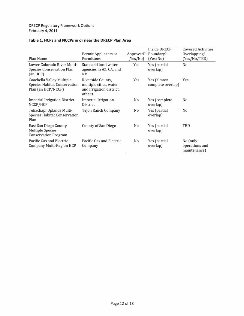
Table 1. HCPs and NCCPs in or near the DRECP Plan Area
Plan Name Permit Applicants or Permittees
Approved? (Ye o) s/N
Inside DRECP Boundary? (Yes/No)
Covered Activities rlapping? s/No/TBD)
Ove(Ye
Lower Colorado River Multi‐ Species Conservation Plan
(an HCP)
State and local water , and agencies in AZ, CA
NV
Yes Yes (partial overlap)
No
Coachella Valley Multiple Species Habitat Conservation Plan (an HCP/NCCP)
t
Riverside County, multiple cities, water
ct, and irrigation distriothers
Yes Yes (almost complete overlap)
Yes
Imperial Irrigation DistricNCCP/HCP Tehachapi Uplands Multi‐
vation
Imperial Irrigation District Tejon Ranch Company
No
No
Yes (compleoverlap) Yes (partial
te No
No Species Habitat ConserPlan East San Diego County
overlap)
Yes (partial Multiple Species Conservation Program Pacific Gas and Electric Company Multi‐Region HCP
County of San Diego No overlap)
Yes (partial overlap)
TBD
Pacific Gas and Electric Company
No No (only operations and maintenance)
Page A‐1
Appendix A Relevant Federal Planning Efforts on BLM Administered
Lands in the Proposed Plan Area
The Bureau of Land Management (BLM) administers over 40% of the land within the Desert Renewable Energy Conservation Plan (DRECP) Plan Area. Along with other federal agencies, the BLM is involved with numerous regional environmental planning efforts that address the same or similar activities to those that will be covered by the DRECP. Federal programs and their associated environmental compliance that address the same suite of activities as the DRECP or that have the potential to be influenced or amended by the DRECP are discussed below. Of these federal programs, the BLM Draft Solar Programmatic Environmental Impact Statement (Solar PEIS) was released for public comment on December 17, 2010 for a 90‐day public comment period. The BLM Wind and Geothermal PEIS’s have been completed. The California Desert Conservation Area (CDCA) Plan of 1980was amended by the Wind and Geothermal PEIS’s and continues to be amended as needed in response to changes in management and policy that affect the California desert. Because the most recent CDCA amendments did not contemplate the current scale of solar energy development, and the Solar, Geothermal, and Wind PEIS’s were completed at a regional scale of either national or western states, the more specific and detailed analyses for DRECP may require another round of CDCA Plan amendments as well.
BLM Solar Programmatic Environmental Impact Statement
The BLM, along with the U.S. Department of Energy (DOE), has released the Draft Solar PEIS to evaluate a proposed solar‐energy program on BLM lands in six western states (Arizona, California, Colorado, New Mexico, Nevada, and Utah). The proposed program would establish an environmental policy for the deployment of DOE‐supported, utility‐scale solar projects and would include the development of mitigation strategies, the establishment of best management practices (BMPs), and the creation of siting criteria. The multi‐state planning area addressed by the Draft Solar PEIS encompasses the Mojave and Colorado desert regions that are the focus of the DRECP. This process was initiated in 2008 and is ongoing. A Draft Solar PEIS was released for public comment on December 17, 2010. The Final Solar PEIS is expected to be completed in late 2011. The environmental policies developed by the BLM through the Solar PEIS would apply only on BLM administered lands.
The BLM is actively involved in the development of both the Solar PEIS and the DRECP and will coordinate based on commitments made by the U.S. Department of Interior (DOI) and the State of California in a 2009 Memorandum of Understanding, to the best of its ability. For more information on the Solar PEIS process, see http://solareis.anl.gov.
BLM Wind Programmatic Environmental Impact Statement
The Wind PEIS was completed and a Record of Decision issued by the DOI and BLM in June 2005 to evaluate the Wind Energy Development Program for public lands in the Western United States. This program was developed to support National Energy Policy recommendations to increase renewable energy production and is focused on the development of wind energy on public lands and the
DRECP Regulatory Framework Options Feb
Page A‐2
ruary 4, 2011
amendment of selected BLM land use plans. The program establishes policies and BMPs for wind‐energy development and identifies minimization and mitigation measures. As the result of the proposed action, 52 land use plans in Colorado, Idaho, Montana, Nevada, New Mexico, Oregon, Utah, Washington, and Wyoming were amended. Land use plans in California were not amended in response to the Wind PEIS because ongoing and future land use plan amendments were meant to address wind energy development in California for areas where potential projects may occur. The BMPs and policies in the Wind PEIS do apply to California. The environmental policies developed by the BLM through the Wind PEIS apply only on BLM administered lands. It is anticipated that the Wind PEIS will inform the DRECP in a number of ways including as a source of mitigation measures to avoid, minimize, and mitigate impacts to covered species. The Wind PEIS is likely to be particularly helpful for the DRECP environmental Impact report/environmental impact statement (EIR/EIS). For more information on the Wind PEIS see http://windeis.anl.gov/eis/index.cfm.
BLM Geothermal Programmatic Environmental Impact Statement
In October 2008, the BLM and the USDA Forest Service (USFS) completed a joint Geothermal PEIS to analyze and expedite the leasing of BLM‐and USFS‐administered lands with high potential for renewable geothermal resources in 11 western states and Alaska. The effort was initiated in response to recent government policies and technological advances that increased the demand for accessing geothermal resources on federal lands. These lands include areas administered by the BLM and the USFS. (Federal lands within the National Wildlife Refuge System and the National Park System are closed to geothermal leasing, and adjacent public and National Forest System lands require special analysis prior to issuance of geothermal leases.) The program identified public and National Forest Service lands with potential for geothermal development as being open or closed and to issue (or deny) lease applications pending as of January 2005. The BLM will also identify public lands that are administratively closed or open to leasing, and under what conditions; develop BMPs for future geothermal leasing and development activities; and amend BLM land use plans to adopt these changes. It is anticipated that the Geothermal PEIS will inform the DRECP in ways similar to that described for the Wind PEIS. For more information on the Geothermal PEIS, see http://www.blm.gov/wo/st/en/prog/energy/geothermal/geothermal_nationwide.html.
California Desert Conservation Area Plan
The CDCA is a 25‐million acre expanse of land in southern California designated by Congress in 1976 through the Federal Land Policy and Management Act (FLPMA). About 10 million acres within the CDCA are administered by the BLM. The DRECP Plan Area overlaps substantially with the CDCA. As part of the designation, Congress required the preparation of a long‐range plan for the CDCA, the purpose of which is to provide guidance to the BLM for the management of these lands. The plan seeks to balance use of public lands and resources in the CDCA, including economic, educational, scientific, and recreational uses with the desert’s aesthetic value and its “productivity.” The original CDCA Plan was approved in 1980 and amended many times since in response to updated policies and programs developed by BLM that apply to the CDCA.
The CDCA Plan is the parent land use plan for BLM in the DRECP Plan Area. Several major resource management plans (RMPs) amended the CDCA Plan including West Mojave RMP Amendment (2006), Northern & Eastern Mojave RMP Amendment (2002), Northern and Eastern Mojave Route Designation RMP Amendment (2004), Western Colorado Route Designation RMP Amendment
DRECP Regulatory Framework Options Feb
Page A‐3
water storage facilities, existi
ruary 4, 2011
(2003), Northern and Eastern Colorado RMP Amendment (2002) and Coachella Valley RMP Amendment (2002). The CDCA Plan was amended by the Wind and Geothermal PEIS processes described above. The BLM has proposed that, once approved, the Solar PEIS (also described above) would amend the CDCA Plan.
The BLM is also embarking on a CDCA amendment associated with the DRECP. BLM issued a Notice of Intent and scoped for this amendment in fall‐winter 2009. BLM plans on using the DRECP conservation strategy as the foundation of an alternative in the CDCA amendment EIS. A schedule for development and release of a draft EIS will be set in spring 2011.
Relevant Non‐Federal Planning Efforts in the DRECP Plan Area There are several non‐federal regional conservation plans in the DRECP Plan Area that are relevant to the DRECP. These plans are discussed below, shown in Figure 1, and summarized in Table 1.
Each of the conservation plans identified below will be used as a resource in the development of the DRECP as a result of their overlapping or adjacent plan areas, natural communities, and covered species. Mapping methods, natural community and land cover types, and species accounts will be reviewed to inform the DRECP. Where applicable, conservation strategies, monitoring and adaptive management approaches, avoidance and minimization measures, and implementation strategies will be evaluated for inclusion in the DRECP7. For each of the regional conservation plans, the expected interaction between the plan and the DRECP is also discussed.
Completed and Approved Plans
Coachella Valley Multiple Species Habitat Conservation Plan
Approved in 2008, the Coachella Valley Multiple Species Habitat Conservation Plan (MSHCP), an HCP and NCCP, covers the entire Coachella Valley in Riverside County and seeks to conserve 27 covered species of plants and animals and natural communities, including the state endangered, federally threatened Coachella Valley fringe‐toed lizard, federally endangered desert pupfish, and federally threatened desert tortoise. The Reserve System for the plan will consist of approximately 725,000 acres, which will be composed of federal, state, Permittee, and non‐profit lands. .
The nineteen permit holders include sixteen Local Permittees (Riverside County, eight cities, and several utility districts) and three state Permittees (Coachella Mountains Conservancy, California Department of Transportation, and California Department of Parks and Recreation). The city of Desert Hot Springs was originally a participant in the plan but opted out just prior to plan adoption; they are now preparing a plan amendment to rejoin the Coachella Valley MSHCP.
The Coachella Valley MSHCP provides take authorization for numerous covered activities on non‐federal lands. It does not cover take from agricultural activities but does cover the conversion of agriculture to covered activities. Authorized activities include permitted developments by Local Permittees, the construction, operation, and maintenance of public facilities (e.g., debris basins,
ng roads), emergency response relative to these activities, a wide
7 The project team will also consult regional conservation plans in other parts of California and the United States for best practices and good examples of tools and approaches to apply to the DRECP.
DRECP Regulatory Framework Options Feb
Page A‐4
ruary 4, 2011
variety of transportation projects (both local and regional), and water‐storage and ‐delivery projects.
Development permitted or approved by Local Permittees is a covered activity under the Coachella Valley MSHCP. The construction of wind‐energy projects is covered by the Coachella Valley MSHCP, but the operation of wind farms is specifically excluded (see page 7‐16 of the Coachella Valley MSHCP). Solar and other renewable energy projects are not specifically identified; however, if their impacts fall within the scope of the analysis and the projects are subject to the jurisdiction of one of the Local Permittees, then solar and other renewable energy projects could be covered by the Coachella Valley MSHCP. Virtually all future renewable energy development likely would occur within the jurisdiction of Riverside County and the City of Palm Springs, the only two municipalities with existing renewable energy development.
The Coachella Valley MSHCP allows for renewable energy development inside and outside plan‐designated conservation areas. To ensure consistency with plan requirements, renewable energy projects require a “Joint Project Review Process” when proposed inside conservation areas, subject to sideboards established in the plan. The Coachella Valley MSCP plan area was almost entirely encompassed within the original DRECP Plan Area (overlap of 94% or 1,132,317 acres). Because of the overlap in covered activities and covered species in the Coachella Valley MCHCP plan area and the DRECP, the REAT agencies decided to exclude the Coachella Valley MSHCP from the DRECP Plan Area. For more information on the Coachella Valley MSHCP, see http://cvmshcp.org/.
Lower Colorado River Multi‐Species Conservation Plan
The Lower Colorado River Multi‐Species Conservation Plan (MSCP) is an HCP/NCCP that spans three states (California, Arizona, and Nevada) covering 400 miles of the lower Colorado River from Lake Mead to the Mexican border. The plan, approved in 2005, encompasses the Colorado River’s 100‐year floodplain and associated reservoirs. This 50‐year plan is being implemented by the Bureau of Reclamation to allow for continued water supply and hydroelectric power production for Nevada, Arizona, and California. The plan covers 26 sensitive species within four habitat types (aquatic, emergent marshes, lower terrace cottonwood and willow riparian woodlands, and upper terrace native mesquite bosques).
The Lower Colorado River MSCP overlap with the DRECP is limited. Five percent of the Lower Colorado River MSCP plan area overlaps with the DRECP Plan Area, or 1,223,988 acres. The Lower Colorado River MSCP covers hydroelectric facilities along the Colorado River but does not cover other renewable energy projects. Because the Lower Colorado River MSCP focuses on aquatic and riparian species, the overlap with the DRECP covered species is expected to be very limited.
Plans in Progress
Imperial Irrigation District Natural Communities Conservation Plan and Habitat Conservation Plan
The Imperial Irrigation District (IID) diverts Colorado River water for agricultural, industrial, rural‐residential and municipal use within a defined service area of Imperial County. An extensive drainage system is also maintained that allows for agricultural runoff. The IID signed a planning agreement with the California Department of Fish and Game (DFG) and the U.S. Fish and Wildlife
DRECP Regulatory Framework Options Feb
Page A‐5
ruary 4, 2011
Service (USFWS) in February 2006 to prepare an NCCP/HCP (IID NCCP/HCP). The planning area includes the IID service area, other IID properties, rights of way along the All‐American Canal, and specified drains and infrastructure. The total geographic area to be addressed is approximately 500,000 acres in Imperial County and a small portion of Riverside County. The IID NCCP/HCP is not yet permitted and has not gone through environmental review.
The Plan permit is anticipated to cover 96 fish, wildlife, and plant species for a term of up to 75 years. Covered activities include all water conservation projects undertaken by IID as well as by farmers, tenants, or landowners, in connection with the conservation and transfer of Colorado River water delivered by IID. Activities related to IID Water Department operations including water delivery, drainage, and operations and maintenance will also be covered by these permits.
It is anticipated that the IID NCCP/HCP and the DRECP will overlap in terms of their plan areas and some of their covered species. The activities covered under the IID NCCP/HCP are not anticipated to overlap with those proposed for the DRECP.
Tehachapi Uplands Multi‐Species Habitat Conservation Plan
The Tehachapi Uplands Multi‐Species Habitat Conservation Plan (MSHCP) initially began as a conservation plan to minimize and mitigate impacts to the California condor expected from activities on Tejon Ranch. The plan has since evolved to cover an additional 26 species of plants and animals. The plan proposes to cover activities on the privately‐owned Tejon Ranch, including development in designated areas. At nearly 270,000 acres, Tejon Ranch is the largest contiguous expanse of private land in California. The Ranch is located along Interstate 5, approximately 60 miles north of Los Angeles and 30 miles south of Bakersfield. The plan proposes to cover almost 142,000 acres and proposes to preserve 94% as open space, including a 37,000‐acre Condor Study Area. The draft Tehachapi Uplands MSHCP and its draft EIS were released for public review in 2010. The final Tehachapi Uplands MSHCP and final EIS are currently being prepared and expected to be completed in 2011. A permit decision by USFWS is also proposed for 2011. The plan is designed to cover existing and ongoing ranching and related activities. The draft plan does not currently include renewable energy development as a proposed covered activity. Approximately 44% of the Tehachapi Uplands MSHCP overlaps with the DRECP Plan Area.
The area of overlap with the original DRECP plan area would mostly be designated as open space by the Tehachapi Uplands MSHCP and would therefore be unavailable for renewable energy development. In addition, current and expected conservation easements on private land on Tejon Ranch outside of the Tehachapi Uplands MSHCP would prohibit renewable energy development. For these reasons, the DRECP boundary was adjusted to exclude all of Tejon Ranch. For more information on the Tehachapi Uplands MSHCP, see http://www.tejonconservationplan.com.
East San Diego County Multiple Species Conservation Program
The East San Diego County Multiple Species Conservation Program (MSCP) is an in‐process HCP/NCCP that was initiated in 2005. The East San Diego County MSCP is the third of three plans developed by the County of San Diego, and includes approximately 1.6 million acres. The East San Diego County MSCP is expected to cover rural‐ and small‐community development, infrastructure projects, and agricultural activities in the unincorporated portions of eastern San Diego County. This HCP/NCCP is the third of three plans developed by the County of San Diego, and covers
DRECP Regulatory Framework Options Feb
Page A‐6
ruary 4, 2011
approximately 1.6 million acres. The East San Diego County MSCP plan area overlaps with the DRECP Plan Area by approximately 268,530acres, or 17%.
The plan currently proposes to conserve over 100 sensitive species and their habitats while accommodating continued economic growth. The outcome of the East San Diego County MSCP will be the creation of a large, connected preserve system that addresses the regional habitat needs for these species. The East San Diego County MSCP is currently on hold pending completion of the northern San Diego County HCP/NCCP. The East San Diego County MSCP likely will cover renewable energy development within its plan area.
The proposed East San Diego County MSCP plan area currently overlaps with the DRECP Plan Area by approximately 268,530 acres, or 17%. Modification of the DRECP Plan Area boundary is being considered to exclude the East San Diego County MSCP plan area because most of the overlap does not occur in the desert, and the portion that does is almost entirely within Anza‐Borrego Desert State Park.
Pacific Gas and Electric Company Multi‐Region Habitat Conservation Plan for Operation and Maintenance of Existing Facilities
The Pacific Gas and Electric Company (PG&E) Multi‐Region Habitat and Conservation Plan for Operation and Maintenance of Existing Facilities (Multi‐Region HCP) covers five of PG&E’s service territories—the Central Coast, North Coast, Sacramento Valley, Sierra Nevada, and the Mojave Desert. The plan is an HCP but not an NCCP (compliance with the California Endangered Species Act will be through Section 2081(b)). The Multi‐Region HCP will enable PG&E to continue current and future operation and maintenance (O&M) activities on gas and electric transmission and distribution infrastructure while minimizing, avoiding, and compensating for possible adverse effects on listed and sensitive species. The Multi‐Region HCP proposes to cover more than 50 wildlife and 75 plants species and spans approximately one‐third of California. The plan is in development and the draft Multi‐Region HCP and draft EIS have not yet been released for public comment. The final EIS and permit decision by USFWS and DFG are expected in 2012 or 2013.
While the plan area for the Multi‐Region HCP covers over 67,121 acres within the DRECP boundary, the PG&E permit area follows the rights‐of‐way for transmission and distribution infrastructure and occurs in a small portion of the lands within those 67,121 acres. Covered activities in the Mojave Desert where the plans overlap will be focused on the operation and maintenance of existing gas lines. The Multi‐Region HCP is not expected to include the development of new renewable energy projects.
M o n o
I m p e r i a l
S a n D i e g o
F r e s n o
I n y o
T u l a r e
S a n B e r n a r d i n o
K e r n
L o s A n g e l e s
R i v e r s i d e
§̈¦15
§̈¦15
§̈¦40
§̈¦15
§̈¦10
§̈¦5
§̈¦15
§̈¦805
§̈¦110
§̈¦40
§̈¦405
§̈¦5
§̈¦5
§̈¦10
§̈¦210
§̈¦215
§̈¦605
§̈¦10
§̈¦8
£¤95
£¤101
£¤395
£¤395
£¤6
£¤95
£¤66
NeedlesBarstow
Victorville
Twentynine PalmsSan Bernardino
Riverside
Coachella
Brawley
Glendale
Los Angeles
Long Beach
San Diego
Bishop
0 25 50Miles
±
Major Roads
County Boundary
!( City
Water Bodies
Other Habitat Conservation Plans
Completed and Approved Plans
Coachella Valley MSHCP
Lower Colorado River MSCP
Western Riverside County MSHCP
Plans in Progress
Imperial Irrigation District NCCP/HCP
East San Diego County MSCP
Tehachapi Uplands MSHCP
PG&E Company Multi-RegionHCP for O&M of Existing Facilities
Data Sources: CNDDB, 2009; ESRI, 2010; Greeninfo, 2009; Dudek, 2010
Figure 1Habitat Conservation Plans in and
Near the DRECP Plan Area
Gra
ph
ics
/Pro
ject
s/00
740.
10 A
spen
DRE
CP/
Stra
teg
ic P
lan
nin
g/R
egu
lato
ry F
ram
ewo
rk (0
1-11
)SS
DRECP Comprehensiveor Focused HCP/NCCP
CaliforniaEnergy
Commission
Power PlantCertification
Permit to Construct or
Certificate of Public Convenienceand Necessity
Section 7 Consultationsand Right-of-Way
Grant or Lease
• Wind• Solar Photovoltaic• Solar Thermal, Biomass, or Geothermal less than 50 MW
• Solar Thermal, Biomass, or Geothermal 50 MW or greater
• Electric Transmission Lines by Investor- Owned Utilities
ON PRIVATE ORLOCAL PUBLIC LAND
• Wind• Solar Photovoltaic• Solar Thermal• Biomass• Geothermal• Electric Transmission Lines
ON FEDERAL LAND
CaliforniaPublic UtilitiesCommission
Counties
Federal ActionAgencies
• Bureau of Land Management• National Park Service• Department of Defense• Department of Energy
Participate throughImplementing
Agreement and/orResource
Management PlanAmendments
Apply Plan throughOther Regulatory Mechanism
Covered Activity ReceivingTake Authorization(excludes conservation actions)
PermitMechanism
Permit Holderat Plan Completion
Permit Holderafter Plan Completion(optional)
Legend
Figure 2Options A and B: Comprehensive or Focused Plan
Gra
phic
s /P
roje
cts/
0074
0.10
Asp
en D
RECP
/Str
ateg
ic P
lann
ing/
Regu
lato
ry F
ram
ewor
k (0
1-31
-11)
SS
LocalLand UseApprovals
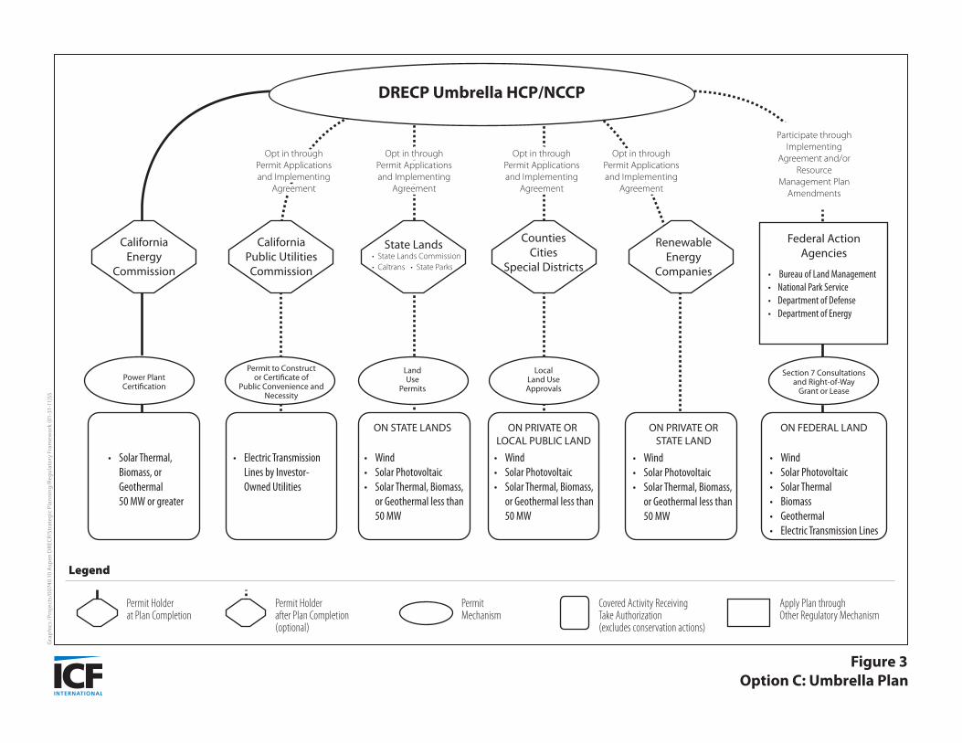
Figure 3Option C: Umbrella Plan
Gra
phic
s /P
roje
cts/
0074
0.10
Asp
en D
RECP
/Str
ateg
ic P
lann
ing/
Regu
lato
ry F
ram
ewor
k (0
1-31
-11)
SS
DRECP Umbrella HCP/NCCP
CaliforniaEnergy
Commission
RenewableEnergy
Companies
Opt in throughPermit Applicationsand Implementing
Agreement
Opt in throughPermit Applicationsand Implementing
Agreement
Opt in throughPermit Applicationsand Implementing
Agreement
Opt in throughPermit Applicationsand Implementing
Agreement
Participate throughImplementing
Agreement and/orResource
Management PlanAmendments
• Wind• Solar Photovoltaic• Solar Thermal, Biomass, or Geothermal less than 50 MW
• Solar Thermal, Biomass, or Geothermal 50 MW or greater
• Electric Transmission Lines by Investor- Owned Utilities
ON PRIVATE OR LOCAL PUBLIC LAND
• Wind• Solar Photovoltaic• Solar Thermal, Biomass, or Geothermal less than 50 MW
ON PRIVATE ORSTATE LAND
• Wind• Solar Photovoltaic• Solar Thermal, Biomass, or Geothermal less than 50 MW
ON STATE LANDS
• Wind• Solar Photovoltaic• Solar Thermal• Biomass• Geothermal• Electric Transmission Lines
ON FEDERAL LAND
CaliforniaPublic UtilitiesCommission
CountiesCities
Special Districts
State Lands Federal ActionAgencies• State Lands Commission
• Caltrans • State Parks• Bureau of Land Management• National Park Service• Department of Defense• Department of Energy
Permit to Constructor Certificate of
Public Convenience andNecessity
LandUse
Permits
Section 7 Consultationsand Right-of-Way
Grant or Lease
Power PlantCertification
Apply Plan throughOther Regulatory Mechanism
Covered Activity ReceivingTake Authorization(excludes conservation actions)
PermitMechanism
Permit Holderat Plan Completion
Permit Holderafter Plan Completion(optional)
Legend
LocalLand UseApprovals