Embed Size (px)
Citation preview

Page 1 Application for a definitive map and statement modification order to record a footpath from Footpath 125, Weymouth to Castle Cove Beach; and Proposed definitive map and statement modification order to correct the recorded route of part of Footpath 125, Weymouth
Regulatory Committee
Date of Meeting 17 August 2017
Local Member(s):
Cllr Clare Sutton - Member for Rodwell
Lead Officer(s)
Phil Hobson, Senior Definitive Map Officer, Regulation Team
Subject of Report Application for a definitive map and statement modification order to record a footpath from Footpath 125, Weymouth to Castle Cove Beach; and Proposed definitive map and statement modification order to correct the recorded route of part of Footpath 125, Weymouth
Applicant Mr Tony Dobbs, Friends of Castle Cove
Executive Summary In response to an application to add a footpath linking the (closed) Footpath 125 to Castle Cove Beach, this report considers the evidence relating to the status of the route. In addition, as it has been identified that the western end of Footpath 125 may be shown offline on the definitive map, this report also considers a proposal to correct the route to that currently used.
Impact Assessment: Equalities Impact Assessment: An Equalities Impact Assessment is not a material consideration in considering this application.
Use of Evidence: The applicant submitted documentary evidence in support of his application.
Agenda item:
5

Page 2 Application for a definitive map and statement modification order to record a footpath from Footpath 125, Weymouth to Castle Cove Beach; and Proposed definitive map and statement modification order to correct the recorded route of part of Footpath 125, Weymouth
Documentary evidence has been researched from sources such as the Dorset History Centre and the National Archives. A full consultation exercise was carried out in August 2016, which included landowners, user groups, local councils, those affected and anyone who had already contacted Dorset County Council regarding this application. The County Councillor for Rodwell, Clare Sutton, was also consulted. In addition notices explaining the application were erected on site. 77 user evidence forms from users of the claimed route were submitted during the investigation. Any relevant evidence provided has been discussed in this report.
Budget: Any financial implications arising from this application are not material considerations and should not be taken into account in determining the matter.
Risk Assessment: As the subject matter of this report is the determination of a definitive map modification order application the County Council's approved Risk Assessment Methodology has not been applied.
Other Implications: None
Recommendations That:
(a) The application to add a footpath as shown C – E on Drawing 16/13/1 (Appendix 1) be refused;
(b) An order be made to modify the definitive map and statement of rights of way to:
(i) Delete part of Footpath 125, Weymouth as shown A – B; and
(ii) Add part of Footpath 125, Weymouth as shown D – B
on Drawing 16/13/1 (Appendix 1); and
(c) If the Order is unopposed, or if any objections are withdrawn, it be confirmed by the County Council without further reference to this Committee.

Page 3 Application for a definitive map and statement modification order to record a footpath from Footpath 125, Weymouth to Castle Cove Beach; and Proposed definitive map and statement modification order to correct the recorded route of part of Footpath 125, Weymouth
Reasons for Recommendations (a) In respect of the application to add a new footpath, the
available evidence shows, on balance, that the claimed right of way does not subsist nor can be reasonably alleged to subsist;
(b) In respect of the proposal to correct the recorded route of part of Footpath 125 the available evidence shows, on balance that:
(i) There is no public right of way over land as shown A – B as a highway of any description; and
(ii) A right of way, a public footpath, subsists or is reasonably alleged to subsist over land as shown D – B; and
(c) The evidence shows, on balance, that the route of part of Footpath 125 requires modification as proposed. Accordingly, in the absence of objections the County Council can itself confirm the Order without submission to the Planning Inspectorate.
Decisions on applications for definitive map modification orders ensure that changes to the network of public rights of way comply with the legal requirements and achieves the corporate plan objectives of:
Enabling Economic Growth
Work in partnership to ensure the good management of our natural and historic environment
Work with partners and communities to maintain cycle paths, rights of way and disabled access
Encourage tourism to our unique county Support community transport schemes
Promoting Health, Wellbeing and Safeguarding
Actively promote physical activity and sport Develop and maintain safe, convenient, efficient and
attractive transport and green infrastructure that is conducive to cycling and walking
Improve the provision of, and access to, green, open spaces close to where people live
Appendices 1 - Drawing 16/13/1
2 - Law
3 - Documentary evidence Table of documentary evidence Extracts from key documents
▪ Ordnance Survey maps - 1868 scale 1:10560 (enlarged) - 1938 scale 1:2500

Page 4 Application for a definitive map and statement modification order to record a footpath from Footpath 125, Weymouth to Castle Cove Beach; and Proposed definitive map and statement modification order to correct the recorded route of part of Footpath 125, Weymouth
▪ County Council Mapping - Borough Survey 1951 - Draft map 1954 - Provisional map 1964 - First definitive map 1966 - Revised draft map 1974 - Current definitive map 1989
▪ Agreements - 1936 - 2009 - 2012
4 - User evidence
Table of user evidence Charts to show periods and level of use
Background Papers The file of the Service Director, Highways and Emergency Planning (ref. RW/T535).
Most of the original historic maps referred to are in the custody of the Dorset History Centre.
Copies (or photographs) of the documentary evidence can be found on the case file RW/T535, which will be available to view at County Hall during office hours.
Report Originator and Contact
Name: Phil Hobson Senior Definitive Map Officer Regulation Team, Dorset Highways Tel: (01305) 221562 Email: [email protected]

Page 5 Application for a definitive map and statement modification order to record a footpath from Footpath 125, Weymouth to Castle Cove Beach; and Proposed definitive map and statement modification order to correct the recorded route of part of Footpath 125, Weymouth
1 Background
1.1 An application to add a footpath as shown between points C and E on Drawing 16/13/1 (Appendix 1) was made by Mr A Dobbs on behalf of the Friends of Castle Cove on 29 October 2014.
1.2. This application had been prioritised but following a request by the applicant to the Secretary of State for Environment, Food and Rural Affairs in November 2015, the Secretary of State directed that the application should be determined without further delay, setting a date of 17 July 2017 for such determination to have been concluded. Unfortunately, due to officer illness this date was missed but the Planning Inspectorate advised that, as long as progress was being made, they would not be chasing the County Council.
Footpath 125, Weymouth
1.3 During the course of the investigation it was also discovered that there was a drafting error on the definitive map, which had resulted in the route of Footpath 125, Weymouth being recorded incorrectly. It is currently shown to follow a route as shown between points A and B on Drawing 16/13/1, commencing from point A on Old Castle Road continuing east then north-east to point B. Officers consider that the correct route of Footpath 125 is as shown between points D and B.
1.4 Accordingly it is considered that Footpath 125 commences at point D, leading east down a flight of 5 concrete steps with metal hand rails and railings to both sides, the surface is concrete (steps) and tarmacadam. There is a second flight of 8 steps located at point D1 that lead to a timber constructed footbridge at point D2. The surface is tarmacadam. The width from points D to D1 is approximately 1.3 metres, the width from D1 to B is approximately 1.4 metres.
Application Route
1.5 The claimed route commences at point C, as shown on Drawing 16/13/1, leading down the steep face of the coastal slope towards Castle Cove beach at point E. The surface comprises loosely bound clay with roughly cut steps, it is steep and uneven with ropes to the western side to assist users in climbing or descending. It is approximately 1 metre in width and heavily eroded.
1.6 According to the records of the Land Registry the land affected by both the correction of the error in the recorded route of Footpath 125 on the Definitive Map and by the application to add a footpath to the definitive map is owned by Commodore’s Row Management Limited of 2 Commodore’s Row, 62 Old Castle Road, Rodwell, Weymouth, Dorset DT4 8QE.

Page 6 Application for a definitive map and statement modification order to record a footpath from Footpath 125, Weymouth to Castle Cove Beach; and Proposed definitive map and statement modification order to correct the recorded route of part of Footpath 125, Weymouth
Temporary Traffic Regulation Orders
1.7 Parts of Footpath 125 as shown between points D2 – B – C have been subject to a series of Temporary Traffic Regulation Orders (TTROs) and one is currently in force (November 2016). The effect of these Orders is to close parts of the route to pedestrian traffic for health and safety reasons due to damage to the footpath and instability. In addition a substantial length of Footpath 125 continuing east of point C has been the subject of a permanent closure since 2001, due to unstable ground.
2 Law
2.1 A summary of the law is contained in Appendix 2.
3 Documentary evidence (Appendix 3) (copies available in the case file RW/T535)
3.1 A table of all the documentary evidence considered during this investigation is contained within Appendix 3. Extracts from the key documents are also attached.
4 User evidence (Appendix 4) (copies available in the case file RW/T535)
4.1 A table of user evidence summarised from witness evidence forms together with charts showing their periods and level of use form Appendix 4. An analysis of the user evidence is contained at paragraph 9 of this report.
5 Additional evidence in support of the application (copies available in the case file RW/T535)
5.1 Additional evidence has been submitted in support of this application and is summarised in the table below.
Name Comments
A Dobbs (Friends of Castle Cove) 31/10/2014
Copy of a licence and plan made between Commodore’s Row Management and Weymouth & Portland BC, date redacted, in respect of access via steps to Castle Cove beach.
A Dobbs (Friends of Castle Cove Beach) Letter of Support from the Castle Cove Beach Sailing Club 05/10/2016
Letter from Mr D Abbott, Trustee, Caste Cove Beach Sailing Club providing details of the history of the club, use of the routes by the public and the Club’s attitude to such use, full details within the body of the report. (See paragraph 10.16.)
6 Evidence opposing the application (copies available in the case file RW/T535)
6.1 Two letters were received as a result of the consultation:

Page 7 Application for a definitive map and statement modification order to record a footpath from Footpath 125, Weymouth to Castle Cove Beach; and Proposed definitive map and statement modification order to correct the recorded route of part of Footpath 125, Weymouth
Name Comments
Commodore’s Row Management Ltd (CRML) 19/08/2016
CRML object to the application. They refer to licence agreement with Weymouth & Portland BC since 1936, suggest the character of the route could not lead to any presumption of dedication. Route has been used permissively. Access to route was via FP 125, which has been closed (TTRO) since 2012. Suggest access is through ‘force’, ignoring barriers, notices. Letter included photographs and copies of licences 1936 & 2012. (See paragraphs 11.1 – 11.11.)
Mr R Tinsley on behalf of Commodore’s Row Management Ltd (CRML) 19/09/2016
Email providing details as to present and previous ownership of the land and a record of a licence issued by CRML in 2009 and correspondence with local school from 2004. Identifies previous owners, Cornhill Estates and Castle Cove Beach Sailing Club. Suggests that similar licences may have been issued by previous landowners but no evidence provided. More detailed analysis in main body of report (see paragraph 11.12).
7 Other submissions received (copies available in the case file RW/T535)
7.1 Another five submissions were received:
Name Comments
C Pinder Senior Archaeologist DCC 5/08/2016
No recorded archaeological finds or features in vicinity. No evidence for consideration.
A Corton, Dorset Wildlife Trust 8/08/2016
No comments, no evidence for consideration.
S & S Alexander 20/08/2016
Used route from 1970 and aware of frequent use of route by many people until closed by Weymouth & Portland Borough Council. Welcomes possible reinstatement of route. No evidence form completed, no plan submitted.
Cllr C Sutton 28/08/2016
Founder member of Friends of Castle Cove, refers to residents’ representations as to the use of route for 40 years or more. States that to her knowledge the steps were never signed as private or permissive, supports the application.
K Gocher, Ramblers, 30/08/2016
Lived in area since 1973, used application route on foot up to 1983 and also the ‘correct’ route of FP 125, and welcomes the application.

Page 8 Application for a definitive map and statement modification order to record a footpath from Footpath 125, Weymouth to Castle Cove Beach; and Proposed definitive map and statement modification order to correct the recorded route of part of Footpath 125, Weymouth
8 Analysis of documentary evidence
Inclosure Award Plan
8.1 A rather poor quality photocopy of the Wyke Regis Inclosure Award Plan 1798, which has been kept in the custody of the Dorset History Centre was available for examination. However, it does not appear to provide any evidence in support of or against the application to add a footpath. Nor does it provide any evidence in respect of the proposed correction to the route of Footpath 125.
Tithe Apportionment and Plan
8.2 The Wyke Regis Tithe Apportionment Plan 1841, which has also been kept in the custody of the Dorset History Centre, was also examined and was found to provide no evidence to assist in the determination of either the application or proposed modification of Footpath 125.
Other documents
Parish of Weymouth Surface Water Drainage Plan
8.3 A plan entitled Parish of Weymouth Surface Water Drainage, dated December 1904, which has also been in the custody of the Dorset History Centre, uses an Ordnance Survey County Series Map at a scale of 25 inches to one mile (1:2500), surveyed in 1863 and revised in 1902. The area around Castle Cove is clearly depicted, including the property called Glenthorne, which now comprises numbers 15, 15a and b and The Garden Cottage, Old Castle Road. It also shows the plot of land to the north of Footpath 125, which is now occupied by numbers 19 and 21 Old Castle Road.
8.4 What is now recorded as Footpath 125, Weymouth is also depicted clearly. It is shown to follow the ‘correct’ route and not that route presently recorded on the definitive map. It is shown to take a generally north easterly direction and has been shaded in orange. At what would be approximately point B on Drawing 16/13/1 a flight of steps, in all probability private, is shown leading from the southern corner of Glenthorne down onto the beach. There is no similar structure or feature depicted at the equivalent of point C, the commencement point of the application route.
This document provides evidence in support of the proposed modification of the recorded route of Footpath 125, Weymouth.
With respect to the application, it indicates that, at the time of the survey, no steps were recorded in the location that would correspond to that of the application route.
Page 9 Application for a definitive map and statement modification order to record a footpath from Footpath 125, Weymouth to Castle Cove Beach; and Proposed definitive map and statement modification order to correct the recorded route of part of Footpath 125, Weymouth
Weymouth Official Guides
8.5 Two editions of the Official Guide to Weymouth, from the years 1935 and 1937 and published by the Publicity Committee of the Weymouth Corporation, have been examined. They both contain references to various walks within the area, the 1937 edition appearing to be a re-print of the earlier edition.
8.6 Under the heading Some Good Walks, To Saundsfoot Castle and the Chesil Beach, there is a reference to Castle Cove, the text of the passage is as follows, “The path goes on by Underbarn – a tangled mass of bush and bramble, gay with flowers, where rare birds are often seen – to Castle Cove, a small yacht anchorage with quiet sands for children to revel in, and ridges of rock where they may find lots of marine treasures at low water. It is generally practicable to descend by the steps and continue along the shore to Saundsfoot Castle.”
8.7 Reference to the Ordnance Survey maps of this period (1926-1938) shows that in the area of Castle Cove there were shown three possible means of access onto the beach. All or some of these may or may not have been considered to be private means of access. However, whilst the text within the Weymouth Guides may suggest that the steps referred to were public, or may have enjoyed that reputation, it nevertheless does not define clearly to which of the three potential means of access it was referring.
Without any further evidence to the contrary, the Weymouth Guides on their own provide no supporting evidence to the application other than to suggest that there was a means of access to the beach and that it may have been considered to be public access.
Dorset County Council Records/Files
8.8 A number of documents from Dorset County Council’s records covering a period from 1993 to 2009 and which relate to Footpath 125, Weymouth and the area around Castle Cove Beach have been examined.
8.9 Several of these documents relate to wayleaves in respect of parts of Footpath 125 located to the east of point C that were lost to subsidence and have no bearing on this application. These wayleaves are discussed at paragraphs 8.38 below.
8.10 However, a memorandum dated 4 September 1996 from the Chief Executive of the Borough Council to the Borough Engineer entitled “STEPS FROM PUBLIC FOOTPATH NO.125 TO CASTLE COVE, WEYMOUTH” reveals that in response to the Engineer’s memorandum of 5 July 1996 and subsequent discussions it was confirmed that no record of any agreement relating to the steps leading down from the footpath could be found.

Page 10 Application for a definitive map and statement modification order to record a footpath from Footpath 125, Weymouth to Castle Cove Beach; and Proposed definitive map and statement modification order to correct the recorded route of part of Footpath 125, Weymouth
8.11 There is also a copy of a letter dated 5 May 1999 to Councillor Wilcox from
Mr Gallivan, Engineering and Harbour Services Manager of the Borough Council in respect of various matters within the Weymouth East Ward. Paragraph 5 of the letter relates to Castle Cove and confirms to Councillor Wilcox that, having checked the Borough Council’s records, the Borough Council did not own or have any responsibility for land in this area. It did acknowledge that from time to time the Borough Council had undertaken repairs, but was under no obligation to do so, the responsibility for such work being that of the landowner.
8.12 A further memorandum dated 11 March 1999 from the Senior Highway Engineer, Mr Muncaster, to the Borough Council’s Legal Services refers to the closure of Footpath 125 from 22 March 1999 in order to undertake essential maintenance works to sections located between Old Castle Road and the Sandsfoot Beach Steps. These works involved the installation of steps, handrails, resurfacing and re-decking of the footbridge with guard-railing and would have taken between 7 and 10 days to complete.
With respect to the proposed modification of the route of Footpath 125 it should be noted that all of the proposed works were undertaken on what is believed to be the ‘correct’ route as shown D – B and not the recorded route as shown A – B.
8.13 A further letter dated 23 September 2003 from Jim Knight MP to Mr Burgess, the Corporate Director of Environmental Services at the Borough Council, relates to a concern raised by a constituent, Mr Austin, in respect of access to Sandsfoot Beach. The concern was in respect of the condition of the steps, which Mr Austin considered to be dangerous. Mr Knight requested clarification as to whether the steps to which Mr Austin referred were private or public property.
8.14 There is a copy of a report and a response to Mr Knight, both of which are dated 28 October 2003. The report was made by Mr Fletcher, the Borough Engineer and sent to Mr Gallivan. Mr Fletcher stated that he had spoken to Mr George, who had informed him that the land upon which the steps were located was under licence to the Borough Council. He continued, stating that the Council had a duty to maintain the steps, which were in poor condition, although some repairs having been undertaken they were now considered acceptable. He also made reference to the Castle Cove Sailing Club steps, which he reported were private, being the property of Cornhill Estates and no public access was available over them.
8.15 The letter of 28 October 2003 to Mr Knight was sent by Mr Gallivan and stated that the foreshore and beach at Sandsfoot was privately owned but that the Council had a long-standing arrangement with the landowner to provide access to the beach and maintain the steps.
There are references within these documents to both Sandsfoot Beach and Castle Cove Beach, it appears that on occasions these may refer to separate agreements and separate steps.

Page 11 Application for a definitive map and statement modification order to record a footpath from Footpath 125, Weymouth to Castle Cove Beach; and Proposed definitive map and statement modification order to correct the recorded route of part of Footpath 125, Weymouth
This evidence indicates that from 1996 to 2003 the Borough Council,
despite a search of their records, were not aware of the existence of a licence or agreement in respect of the steps to Castle Cove Beach until the intervention of Mr George.
Following the provision of this information to Mr Fletcher it appears that the Borough Council then acknowledged that it did have a longstanding arrangement with the landowner.
8.16 A letter dated 1 April 2004 from Mr Warde, Secretary, Commodore’s Row Management Limited to Mr Webb, Senior Countryside Access Officer, Dorset County Council, refers to a right of way (Footpath 125) leading to a flight of steps down to Castle Cove Beach. Mr Warde was anxious to establish the status of the right of way and any responsibility the landowners may have in respect of it. Mr Warde requested confirmation of its status, it being signed as a public bridleway and part of the Hardy Way recreational trail. He also asked for assurance that no public liability or responsibility for maintenance fell to the landowners.
8.17 Mr Webb responded on the 5 April 2004, advising Mr Warde that the right of way was a footpath, Footpath 125, and that the Hardy Way was no longer promoted. He further advised that the surface of the path was the responsibility of the Borough Council, which had an agency agreement to maintain public rights of way, and suggested that the landowners ought to inform their insurers as to the existence of the right of way on their land. With respect to liability Mr Webb declined to advise that the landowners had no liability as they did have responsibility for the maintenance of any hedges, fences and vegetation and to prevent their encroachment onto the path.
8.18 A further memorandum dated 30 November 2004 from Mr Mustoe, Solicitor, Weymouth and Portland Borough Council to Mr Fletcher, the Borough Engineer refers to advice previously provided by Mr Fletcher in respect of Castle Cove beach. Mr Mustoe enclosed a copy of a letter received from the Commodore’s Row Management Ltd and requested Mr Fletcher’s assistance in responding and negotiating less onerous terms for the Council’s licence to provide public access to the beach.
8.19 There is no copy of the response made by Mr Mustoe although a letter to Mr Mustoe from Mr Warde, Commodore’s Row Management Ltd, dated 16 March 2005, refers to Mr Mustoe’s letter of 7 February. Mr Warde states that his views on beach cleaning were strongly influenced by paragraph 2 of item 4 of Mr Mustoe’s letter of 11 November (no copy available) and wished to include both cleaning and maintenance of the steps within the licence to the Council. Mr Warde provided Mr Mustoe with details as to what the members of the Company had determined, namely:
(a) An increase in the licence fee from £1 per year to £1 per week.
(b) To incorporate within any new licence the enclosed revised plan, which excluded a small area for boat storage.

Page 12 Application for a definitive map and statement modification order to record a footpath from Footpath 125, Weymouth to Castle Cove Beach; and Proposed definitive map and statement modification order to correct the recorded route of part of Footpath 125, Weymouth
(c) To serve warning of intent to revoke the licence if the problems of
closing the access from dusk to dawn could not be resolved.
Unfortunately, there is no record of any further correspondence in response to this.
However, this evidence dates from the period immediately after which the property was acquired by the Commodore’s Row Management Ltd and although no evidence of a licence for this period has been submitted the terms of the proposed licence and the language used by both parties does suggest that a licence was being renegotiated and, therefore, that one did exist.
8.20 There is also a record of a meeting that took place at the Barracks, Dorchester on 21 November 2006 in respect of Footpath 125. Amongst those present were Mr Fletcher and Mr Webb. The meeting was primarily to discuss the ongoing problems of stability along the coast and the continued closure of Footpath 125. Mr Fletcher did state that a substantial length of the path was available for use, albeit one way. For those more adventurous a route down a slight slope and a walk along the foreshore was available, which gave continuity to the steps and access to Old Castle Road.
8.21 An email in respect of Castle Cove Beach from Mr Good, Operations Officer, Weymouth & Portland, to members of the Council, dated 28 November 2008, advised the members that the Borough Council had been granted a licence by the Commodore’s Row Management Committee, which allowed for the installation of steps and retention of public access to the beach. Mr Good noted that the step access had been in place since the 1960s. Mr Good stated that the existing licence fee was £1 per annum but that Commodore’s Row Management Ltd wished to increase the rent to £500 per annum.
Mr Good’s initial comments, in all probability, relate to the licence of 26 March 2009, that commenced in June 2008, which refers to the retention of public access to the beach, something he states had been in place since the 1960s and which would support the contention that earlier licences existed, although no evidence of them has been provided.
8.22 Mr Good provided members with a brief history of the site, stating that Castle Cove had been available for community use for many generations and that he felt it was important that this access be retained. He advised them that he had negotiated an incremental increase to the rent over 4 years to meet the £500 figure by 2012/13 and that a draft licence was almost ready for agreement by all parties. Mr Good also made the following observations:
(a) The Council had taken the licence in order to provide insurance to maintain community access.
(b) The area in question had been a traditional place for members of the local community to enjoy their environment and access safe bathing waters.

Page 13 Application for a definitive map and statement modification order to record a footpath from Footpath 125, Weymouth to Castle Cove Beach; and Proposed definitive map and statement modification order to correct the recorded route of part of Footpath 125, Weymouth
(c) Beach ownership was split between several different landowners
although the Commodore’s Row Residents owned the section containing the steps.
(d) Commodore’s Row could serve notice and would expect the Council to remove the steps, make good the ground and seal the area to the public.
(e) Regardless of public outcry the landowners would make it clear they were forced to take such action as a result of increased taxes and Local Government being unwilling to pay more than £1 per year to secure public access.
(f) Occasions in the past, when landowners had attempted to close the area due to public order problems, had been met with vociferous objections.
(g) The Council had a similar licence at Sandsfoot Beach, which was not being questioned, but if the landowners, the Castle Cove Sailing Club, were to become aware that an increased rent had been agreed elsewhere they may feel obliged to request the same.
8.23 A further email from Mr Good dated 9 January 2009 refers to a meeting held on 12 December regarding the renewal of the licence for steps and access to the foreshore at Castle Cove. Mr Good states that, as instructed, he had been in communication with the Commodore’s Row Management Committee to verify points from the meeting, primarily the fixed 5 year term and a rent review procedure. He stated that he had secured the new licence to be a rolling 5 year licence (automatic renewal rights after 5 years) with a rent review based on the fifth year’s retail price index. The 6 month termination clause for both parties was to be retained and once the newly drafted licence was sent through he would circulate it to all before instructing Mr Mustoe to complete.
This appears to relate to the licence of 2008/09 in respect of the steps to Castle Cove Beach. The fact that Mr Good refers to the renewal of a licence suggests that a licence requiring renewal already existed.
Ordnance Survey maps
1 Inch Series (1:63360)
8.24 The small scale Ordnance Survey maps such as the original Ordnance Survey drawings (2 inches:1 mile) and the 1811 First Edition Ordnance Survey map (1 inch:1 mile) do not depict the area in great detail, the features of interest to this application either did not exist at that time or were considered too small or of insufficient interest to be shown. However, the Revised One Inch Ordnance Survey Map 1898 does depict a route by means of a dark single broken line that would generally correspond with that which is believed to be the correct definitive route of Footpath 125, as shown from point D to point B.
Page 14 Application for a definitive map and statement modification order to record a footpath from Footpath 125, Weymouth to Castle Cove Beach; and Proposed definitive map and statement modification order to correct the recorded route of part of Footpath 125, Weymouth
8.25 Both the 1948 Ordnance Survey New Popular Edition Map and the 1960
Seventh Series Ordnance Survey Map, both at a scale of 1 inch:1 mile do not show the claimed route but do depict a route by means of a dark single broken line that would generally correspond to that of Footpath 125 and following the course as shown from D to B on Drawing 16/13/1, rather than the route A to B.
2½ Inch Series (1:25,000)
8.26 The 1958 Edition of the Ordnance Survey Map at a scale of 1:25000 does not show the claimed route but does show the route of Footpath 125, it being clearly defined by two solid lines from point D to beyond point C on Drawing 16/13/1 and then continuing as a single broken line.
6 Inch Series (1:10,560)
8.27 The First Edition Ordnance Survey Map, surveyed in 1864 and published in 1868 at a scale of 6 inches:1 mile (1:10560) does not show the claimed route. It does depict a path or track that would generally correspond with the position of Footpath 125 leading east along the cliff top commencing from what would approximate to point B on Drawing 16/13/1. This track, the route of Footpath 125, is defined by two parallel broken lines but is not annotated as either ‘F.P.’ or ‘B.R.’. There is no disclaimer present on this map (see note in Table of Evidence, Appendix 3).
8.28 The 1903 Second Edition Ordnance Survey Map at a scale of 6 inches:1 mile (1:10560) does not show the claimed route. It does show that by this time the property known as “Glenthorn” had been constructed and the track that was shown commencing from point B on the first edition map has been extended to its present junction with Old Castle Road at point D. A flight of steps leading down on to the beach in the vicinity of point B is also shown. There are no features or structures shown in the vicinity of point C. The route of Footpath 125 is not annotated as either ‘F.P.’ or ‘B.R.’.
8.29 The 1930 Edition Ordnance Survey Map Revised 1926/27 at a scale of 6 inches:1 mile (1:10560) does not show the claimed route. It does show that by this time an additional access track had been constructed adjacent the south eastern side of the section of what is now Footpath 125 shown between points D and B on Drawing 16/13/1. Other minor changes are shown to the route of Footpath 125 further to the east and the development of the general area has expanded. There are no features or structures shown in the vicinity of point C. The route of Footpath 125 is not annotated as either ‘F.P.’ or ‘B.R.’.
8.30 The 1948 Edition Ordnance Survey Map Revised 1938 at a scale of 6 inches:1 mile (1:10560) does not show the claimed route. It depicts generally the same scene as the earlier 1930 edition, the only major changes being the continued development of the area. There are no features or structures shown in the vicinity of point C. The route of Footpath 125 is not annotated as either ‘F.P.’ or ‘B.R.’.

Page 15 Application for a definitive map and statement modification order to record a footpath from Footpath 125, Weymouth to Castle Cove Beach; and Proposed definitive map and statement modification order to correct the recorded route of part of Footpath 125, Weymouth
25 Inch Series (1:2500)
8.31 The 1902 Second Edition Ordnance Survey Map Revised 1901, at a scale of 1:2500 (25 inches: 1 mile) is the map used for the Finance Act valuation and does not depict the claimed route, although it does depict the correct route of Footpath 125. It generally shows the same features as the corresponding 6 inch Ordnance Survey Map 1903. There are no features or structures shown in the vicinity of point C. The route of Footpath 125 is not annotated as either ‘F.P.’ or ‘B.R.’.
8.32 The 1929 Edition Ordnance Survey Map Revised 1926/27, at a scale of 1:2500 (25 inches: 1 mile) does not appear to show the claimed route, although it does show the correct route of Footpath 125. The general features depicted are comparable to the corresponding 6 inch map of 1930. However, an additional flight of steps shown a little distance to the north east of point C are shown. There are no features or structures shown in the vicinity of point C. The route of Footpath 125 is not annotated as either ‘F.P.’ or ‘B.R.’ but is named on the map as the “Underbarn Walk”.
8.33 The Ordnance Survey Map Revised 1937 and published 1938, at a scale of 1:2500 (25 inches: 1 mile) does appear to show the claimed route by way of the depiction of a flight of steps leading down to the beach at or in the vicinity of point C. It also shows the correct route of Footpath 125. Neither the route of Footpath 125 nor the claimed route is annotated as either ‘F.P.’ or ‘B.R.’ but Footpath 125 is named on the map as the “Underbarn Walk”.
With respect to the proposed correction to the route of Footpath 125, the evidence derived from the Ordnance Survey Maps provides good support towards the conclusion that the current definitive line of Footpath 125, as recorded on the definitive map, is shown incorrectly.
With respect to the application route the majority of the Ordnance Survey Maps examined provide no supporting evidence as to its existence. The only exception to this conclusion relates to the depiction of a flight of steps at or in close proximity to point C that was first recorded on the 1938 edition of the 25 inch map, which had been revised in 1937. As they were not recorded on the 1929 edition, revised during 1926/27, this suggests that the steps may have been installed at sometime between 1928 and 1937.
Although Ordnance Survey Maps may provide evidence in support of an application they do not, on their own, provide any conclusive evidence as to the status of the route. They do, however, show the physical characteristics on the ground at the date of the map.

Page 16 Application for a definitive map and statement modification order to record a footpath from Footpath 125, Weymouth to Castle Cove Beach; and Proposed definitive map and statement modification order to correct the recorded route of part of Footpath 125, Weymouth
Commercial maps
8.34 Samples from the large number of small scale maps of Dorset, including Bartholomew’s Maps, available for analysis have been examined. Due to their small scale and the relatively small size of the features of interest shown upon them, it is considered that they provide no evidence in support of or against the application or the proposed correction to the route of Weymouth Footpath 125.
National Parks and Access to the Countryside Act 1949
Borough Survey
8.35 The Borough of Weymouth and Melcombe Regis Survey of rights of way was completed and returned to the County Planning Officer in 1951. Neither Footpath 125 nor the application route had been the subject of any claim to have held any public rights over them.
Draft Map
8.36 The Draft Map for the South area, including Weymouth and Melcombe Regis, published in 1954, demonstrates that at this time neither Footpath 125 nor the application route had been the subject of any claim.
8.37 The omission of Footpath 125 from the draft map was the subject of objections from the Weymouth Civic Society and the Ramblers’ Association, they believed that it ought to have been included as a footpath. The case was initially heard by the Town Planning Committee of the Borough of Weymouth and Melcombe Regis on 20 March 1956 and ratified by the Weymouth and Portland Council on 29 March 1956. Their decision was that the inclusion of the footpath in the draft map should be left for decision at the “Public Inquiry”.
8.38 It is assumed that the Town Planning Committee may have been referring to the National Parks and Access to the Countryside Sub Committee of Dorset County Council, which did conclude that the path should be added to the draft map. An objection was made to this decision that “a PORTION of this path cannot be legally a Public Right of Way”. This was on the grounds that as sections of the original path had been lost, by falling into the sea, and made good through the provision of short replacement sections by the relevant landowners by means of an annual licence, these parts could not be regarded as public paths. This objection was also upheld and the Sub Committee determined that those parts that had been the subject of a covenant with adjacent landowners be deleted from the draft map, the unaffected parts to remain. The addition of the path to the draft map was advertised in the London Gazette on 30 August 1957.

Page 17 Application for a definitive map and statement modification order to record a footpath from Footpath 125, Weymouth to Castle Cove Beach; and Proposed definitive map and statement modification order to correct the recorded route of part of Footpath 125, Weymouth
Provisional map
8.39 There were larger scale editions of the provisional map of public rights of way produced for Weymouth and Portland in 1964 at a scale of 1:10560 (6 inches:1 mile), which records the footpath along the Underbarn Walk as Footpath 125 for the first time. The path is shown with two gaps, as deleted by the Sub Committee in 1957.
First definitive / revised draft / current definitive maps
8.40 The first definitive map was sealed in 1966, the revised draft map 1974 and the current definitive map in 1989.
8.41 All of the rights of way mapping from the provisional map of 1964 up to and including the revised draft map of 1974 record the route of Footpath 125 as that shown between points D and B.
8.42 The current definitive map, sealed in 1989, shows the western end of Footpath 125 as terminating at point A.
The recording of Footpath 125 on the provisional map is well documented, it having been omitted from both the Borough Survey and the draft map, its route at the western end being that shown between points D and B.
For the route to have changed in the intervening period there would be evidence of a legal event such as a diversion or modification. Without such evidence the route should be the same as that recorded on the provisional map.
No evidence of any legal event has been discovered and it is therefore considered that the alteration of the termination point of Footpath 125, as shown on the current definitive map, is the result of a drafting error.
Traffic Regulation Orders
8.43 Those parts of Footpath 125 as shown between points D2 – B – C have been subject to a series of Temporary Traffic Regulation Orders required for health and safety reasons due to damage to the footpath and instability and one is currently in force (from November 2016). The effect of these Orders is to close the route to pedestrian traffic. In addition, a substantial length of Footpath 125 continuing east of point C has been the subject of a permanent closure since 2001, due to the unstable ground.
The use of Footpath 125 in order to gain access to the application route was prohibited during this period and any person so doing would have been liable to a fine not exceeding £1000.
However, available records indicate that the application route was not subject to any of the traffic regulation orders that have been in force or remain in force and consequently its use during this period was not prohibited.

Page 18 Application for a definitive map and statement modification order to record a footpath from Footpath 125, Weymouth to Castle Cove Beach; and Proposed definitive map and statement modification order to correct the recorded route of part of Footpath 125, Weymouth
Coastal Access
8.44 Following Government policy, under Natural England’s remit for improving public access to the coast, the first stretch of the England Coast Path from Rufus Castle, Portland to Lulworth Cove was approved by the Secretary of State on 26 January 2012.
8.45 Coastal access rights came into force along this length of the Coast Path on the 29 June 2012 (see Law, Appendix 2 Paragraph 3), these rights extend within a ‘margin’ of the coastline or foreshore and the designated Coastal Margin between Sandsfoot Castle and Newton’s Cove includes the application route.
8.46 The rights associated with Coastal Access are the same as those of ‘Open Access’ as detailed under the Countryside and Rights of Way Act 2000, the same rights and restrictions applying.
Existing public rights of way that may fall within the Coastal Margin are not affected by Coastal Access and are not subject to any of the restrictions associated with it.
As access to land within the Coastal Margin was permitted by statute from 29 June 2012, subject to any lawful restrictions, any public use of a way not already recorded as a public right of way would not qualify as use ‘as of right’ from that date forward but would be ‘by right’.
Consequently, any use of a way located within the Coastal Margin after this date cannot be used in calculating the 20-year period of use required under Section 31 of the Highways Act 1980 in respect of any claim to add a public right of way to the definitive map.
9 Analysis of user evidence supporting the application
9.1 A total of 77 user forms of evidence have been submitted in support of the application. A summary of these forms of evidence follows, for full details reference should be made to the file of the Service Director, Highways and Emergency Planning, Ref. RW/T535.
9.2 A total of five user forms of evidence have been rejected for some or all of the following reasons:
No accompanying map.
Used a different route to that of the application.
Accompanying plan unsigned or the route used was not defined upon it.
9.3 All of the witnesses state that they used the route on foot and for pleasure, two stating they also used it for work or business. Several witnesses state that they observed another user on a bicycle.

Page 19 Application for a definitive map and statement modification order to record a footpath from Footpath 125, Weymouth to Castle Cove Beach; and Proposed definitive map and statement modification order to correct the recorded route of part of Footpath 125, Weymouth
9.4 The majority of witnesses appear to have used the route on an individual
basis or with family or friends, although the vast majority of them state that they saw many other people using the route.
9.5 The majority of the witnesses do not refer to the presence of any gates or other ‘obstructions’ that would have restricted or prevented their use of the route, nor do they recall ever being challenged or otherwise prevented from using the route. However, several do refer to the presence of a barrier or fence: one witness stated that the barrier was in place in 2013 and they “just moved it to one side”; another stated that they “avoided this section by walking along the beach”.
9.6 Many of the witnesses were aware of temporary closures due to landslips or repairs to the steps. Many were also aware of notices, which in the main related to safety, water quality and littering. However, one witness was aware of the “lease” between the owner and the Weymouth and Portland Borough Council in respect of access to the beach. Another witness suggests that there was a “no entry” sign from approximately the mid-1990s following a land-slip, several others thought that the path was closed as a result of the land-slip. One witness stated that “it was common knowledge that access was at least permitted”.
9.7 Those witnesses that refer to a width suggest that it was between one and two metres wide. Many of the witnesses state that they believed that the owner or occupier must have been aware of public use due to: the numbers using it; the public being encouraged to use it; no attempt being made to prevent such use; it was signposted; its location at the bottom of their garden.
9.8 Two witnesses therefore state that they were aware of an agreement between the Landowner and the Borough Council, both of these witnesses stating that the Commodore’s Row Management Ltd was the owner of the land.
9.9 The earliest year of use was 1938 and the latest year 2014, encompassing a period of 76 years. Their frequency of use varied from daily to six times a year. Use also varied according to the season with more extensive use during the summer period. Over a period of a year, regular use would have occurred on at least a weekly basis.
10 Analysis of evidence in support of the application
Friends of Castle Cove (The Applicant)
10.1 In addition to the user evidence supplied, the applicant, Mr Dobbs on behalf of the Friends of Castle Cove (FCC), provided a statement and supporting documentary evidence with the application in October 2014. There follows a summary and analysis of this evidence, for full details reference should be made to the file of Service Director, Highways and Emergency Planning, Ref. RW/T535.

Page 20 Application for a definitive map and statement modification order to record a footpath from Footpath 125, Weymouth to Castle Cove Beach; and Proposed definitive map and statement modification order to correct the recorded route of part of Footpath 125, Weymouth
10.2 It is Mr Dobbs’ contention that ‘the path’ leading from Footpath 125 to the
beach has been provided with steps for more than a century. Throughout this time Mr Dobbs states that it has been used freely by a large number of people without “let or hindrance”, save for those times when the path was closed for maintenance. Mr Dobbs states that the FCC was formed following the display of a temporary closure notice in 2013 and the subsequent removal of the steps. He further states that it is not the contention of the FCC that steps should be provided only that the route be recognised as a public right of way.
The documentary evidence in the form of the Ordnance Survey maps suggest that, although the steps have not been in place at this location for more than a century as suggested by Mr Dobbs, they may have been in place since around the 1930s.
10.3 Mr Dobbs relates to the history of the area up to 1940, referring to the Ordnance Survey Map of 1899, an extract from which he provided, it being identified as Item 1 in his submission document. It should be noted that it has been reproduced at a scale of 1:1250. Mr Dobbs suggests that it provides evidence as to the existence of steps leading down to the beach from the ‘Underbarn Path’ (Footpath 125) and, although not being shown in the same position as those of the claim, he suggests that it would demonstrate ‘general’ use of the route in the 19th Century. Mr Dobbs cites further supporting evidence as to the existence of steps in the Weymouth Official Guide of 1927, Item 2 (pages 49 & 50).
As Mr Dobbs himself acknowledges, the earlier editions of the Ordnance Survey maps do not show a flight of steps in the location of the claimed path.
An extract from the Weymouth Official Guide of 1927 was provided by Mr Dobbs. The Guides of 1935 and 1937 appear to be reprints and as such their content is discussed above from paragraph 8.5. Whilst they discuss access to the beach they do not on their own provide any clear evidence as to which steps they are referring.
10.4 Mr Dobbs refers to the Ordnance Survey Map surveyed in 1937 (Item 3), suggesting that this map provides clear evidence of the existence of the steps that had, until recently, been located on the application route as well as evidence of two other sets of steps, one of which is probably those as shown on the 1937 map. Mr Dobbs believes that the steps shown on the 1937 map are those that were built following the 1936 agreement between the Weymouth and Melcombe Regis Council and the owners of Glenthorne, on whose land they were erected. He believes these steps to be in the same location as the application route and this is further demonstrated by reference to the Ordnance Survey Maps of 1958 (surveyed 1957) and 1995 (Items 5 & 6) and the extract of the definitive map provided by Dorset County Council in respect of the application (Item 7) provided.
The Ordnance Survey maps to which Mr Dobbs refers are summarised and analysed from paragraph 8.24 above.

Page 21 Application for a definitive map and statement modification order to record a footpath from Footpath 125, Weymouth to Castle Cove Beach; and Proposed definitive map and statement modification order to correct the recorded route of part of Footpath 125, Weymouth
Item 7 is a copy of the GIS mapping representing the working copy
of the definitive map printed in 2014. The steps are not shown on the sealed paper copy dated 1989 at a scale of 1:25000.
10.5 Mr Dobbs is of the opinion that this early evidence assists in demonstrating continuity of the route from at least 1937 to the present day. He also notes that it is important to record that the 1936 agreement was not to provide public access but to permit access for the construction of the steps. He further notes that four witnesses refer to their use of the steps in the 1930s.
Mr Dobbs’ observation as to the wording of the licence in respect of permitting access to construct the steps is correct and there is nothing within the 1936 agreement that specifically refers to public access.
However, it should be noted that, had the route at this time been regarded as a ‘public highway’, it is difficult to understand why permission to carry out improvements to it would have been necessary and why it would have been subject to an annual licence and its associated fee.
10.6 Mr Dobbs continues by referring to evidence in respect of the period post-1940. In addition to the witness statements, which he believes speak for themselves, he notes that many of the witnesses attest to use of the route back to the 1940s, with one witness clearly recalling their use of the route in 1934, although they could not recall the last time they used the route. He refers to another witness who could recall the barbed wire around Portland Harbour during World War 2, testimony supported by another witness who, due to infirmity, was unable to complete a statement.
10.7 Mr Dobbs acknowledges that since 1940 the Underbarn Path (Footpath 125) has been subject to temporary closures due to landslips but notes that these closures did not apply to the application route nor did they, with the exception of the closure of 1999, apply to that part of Footpath 125 between Old Castle Road, point A, and the application route, point C.
Mr Dobbs’ observations in respect of the Temporary Closure Orders are correct.
10.8 With respect to the closure in 1990, Mr Dobbs refers to a letter from the Weymouth and Portland Borough Council Engineer in which it was stated that “This (footpath) stopping-up will be supplemented by a sign at Old Castle Road, indicating “Footpath to the Beach only””. Mr Dobbs suggests that this is an indication that Council officials recognised the application route, the steps, as a public right or route. Mr Dobbs suggests similar circumstances would apply to the closures of 1994 and 2000/01, during which that part of Footpath 125 west of point B remained open, although he acknowledges that the storms of 2000/01 resulted in landslips that eventually resulted in parts of Footpath 125 being extinguished.

Page 22 Application for a definitive map and statement modification order to record a footpath from Footpath 125, Weymouth to Castle Cove Beach; and Proposed definitive map and statement modification order to correct the recorded route of part of Footpath 125, Weymouth
As the Weymouth and Portland Borough Council has acknowledged
entering into agreements with the owners of the land to provide access to the beach by means of the steps and by a payment of a fee, it is not considered that the reference to a “Footpath to the Beach only” within the Engineer’s letter could be construed as the Borough Council recognising the steps as being a recorded or definitive public right of way.
10.9 Mr Dobbs suggests that the only evidence of closure of the steps between 1940 and 2013 was for a period of 7–10 days in March 1999, and provided a memorandum from Weymouth and Portland Borough Council dated 11 March 1999 (Item 10) to that effect.
The memorandum refers to the closure of that part of Footpath 125 as shown west of point B “between Old Castle Road and the Sandsfoot Beach steps” in order to install a flight of steps, handrails, undertake resurfacing work and the re-decking of a footbridge.
Although not entirely clear, this closure appears to relate only to that section of Footpath 125 west of point B and not the application route between points C and E. Although it mentions a flight of steps there are additional steps along this section of Footpath 125 and it is considered that it is these steps to which the memorandum refers.
10.10 Mr Dobbs continues by reference to landownership. Prior to 1970 he believes that the land was owned by the Winzar family, evidence for which he provided a copy of the Castle Cove Sailing Club newsletter dated March 2004 (Item 11). Within the newsletter there is an article about the Founder of the club, Mr A Hownam-Meek, in which it was suggested that the owner of the beach was Mr Ian Winzar.
10.11 Mr Dobbs states that in the early 1970s the land on which the steps are located was acquired by the Caste Cove Sailing Club which, in 1987, approached Weymouth Council with a proposal to divert Footpath 125 directly onto the beach via the yet-to-be-constructed slipway. Although the diversion was not pursued the slipway was constructed and was initially used by both Club members and the public until the provision of gates, which prevented further public use of the slipway.
10.12 In 2002 the Club sold the land to a development company, Cornhill Estates, which constructed 6 houses known as Commodore’s Row. The owners of Commodore’s Row formed a management company, the members of which are the current owners of the land.
10.13 Mr Dobbs understands that current ownership of the land in the vicinity of the steps can be derived from the Land Registry details, a copy of which he provides as Item 12 of his submission. He also provides evidence as to the variety of notices that have been in place over time and to which some of the witnesses may have referred in their statements. More specifically he refers to the temporary closure notices, which he states applied to Footpath 125 only and not the application route, an Environment Agency notice in respect of bathing water quality and a notice requesting people do not leave litter on the beach. A photograph of the latter notice is provided as Item 13.

Page 23 Application for a definitive map and statement modification order to record a footpath from Footpath 125, Weymouth to Castle Cove Beach; and Proposed definitive map and statement modification order to correct the recorded route of part of Footpath 125, Weymouth
Mr Dobbs is correct in his belief that none of the closure notices
applied to the steps, they all applied to part or parts of Footpath 125.
10.14 Mr Dobbs concludes by reference to the evidence of many witnesses who claim to have used the steps in order to access the beach, some of whom he states mentioned queues. He believes that the copy of a postcard of Sandsfoot Cove he has provided in evidence (Item 14), which would predate the postmark of May 1983, demonstrates the widespread use of the beach and that many of these visitors would have accessed the beach by means of the application route: the steps.
The question as to the status of the application route does not dispute that it has been used extensively by the public. However, whilst the postcard itself depicts many people on the beach it provides no direct evidence that any of them used the steps or if they did in what capacity, public or private.
10.15 On 31 October 2014 Mr Dobbs provided additional evidence which he had obtained. Mr Dobbs suggests that it appears to be a successor to the 1936 agreement he referred to in his initial submission. The additional evidence comprises a copy of a licence agreement, undated, between the Commodore’s Row Management Ltd and Weymouth and Portland Borough Council and relating to property at Old Castle Road, Weymouth.
(a) The licence is accompanied by a plan showing the extent of ownership and relates to an agreement on the part of the ‘Licensor’, the Commodore’s Row Management Ltd, to grant the ‘Licensee’, Weymouth and Portland Borough Council, permission to retain a set of access steps leading down to the property shown on the plan (the beach) for the use of the public as detailed within the agreement.
(b) Parts of the agreement, including the date and length of the agreement, have been redacted and it has not been signed, nevertheless it indicated that for a fee the Licensor would grant to the Licensee the right to retain the flight of steps and the right to repair, maintain and renew them throughout the undefined term of the agreement. It also allowed the Licensee to have use of and permit access to the property by the public so that it may be used as a public beach.
(c) The agreement also allowed the Licensor, after consultation, to make reasonable rules and regulations as to the conduct of the public relating to matters such as the playing of games, lighting of fires and access during the hours of darkness, such rules to be enforced by the Licensee. The Licensee also had to provide public liability insurance, maintain the steps in a safe and secure order and provide a refuse bin.
(d) The agreement could be terminated by either party by providing six months’ notice, after which the Licensee would remove the steps and make good any damage.

Page 24 Application for a definitive map and statement modification order to record a footpath from Footpath 125, Weymouth to Castle Cove Beach; and Proposed definitive map and statement modification order to correct the recorded route of part of Footpath 125, Weymouth
The copy of the licence provided by Mr Dobbs is in all probability
a copy or draft of the 2008/09 or 2012 licences. Mr Dobbs’ copy is both undated and unsigned.
Signed copies of the 2008/09 and 2012 licences have been provided by the landowner, the Commodore’s Row Management Ltd, which are summarised and analysed in paragraph 11 below.
Castle Cove Beach Sailing Club
10.16 Mr Dobbs also provided a letter dated 5 September 2016 from Mr Abbott, a Trustee of the Castle Cove Beach Sailing Club, which was sent to Mr Dobbs in response to the modification order application. Mr Abbott states that the Club had operated from various sites on Castle Cove Beach between 1923 and 2002, when they moved to their current site. Throughout this time he states that the Club actively made use of the beach for events and the launching of dinghies.
(a) Mr Abbott states that in 1969 the Club moved from land that they had rented from Mr Winzar, located to the south of Footpath 125, “to what is now known as the Commodore Row site”. In the early 1970s they purchased a parcel of land located to the north of Mr Winzar’s land across which ran Footpath 125. To his knowledge throughout this period the public used Footpath 125 along the route as shown from point D to C via point B and then the steps to the beach as shown between points C and E in a free and open manner and that the Club, as landowners, did not attempt to prevent such use or erect any notices to that affect.
(b) Mr Abbott concludes by stating that the Club was happy to work alongside the public, who used the beach in a friendly and social manner. The Club are of the opinion that the historical route of Footpath 125 commenced at point D and the recorded route as shown from point A is incorrect. They believe their evidence provides support to the definitive map modification order.
Mr Abbott’s evidence suggests that as the owner of the land, from the early 1970s to 2002, the Castle Cove Sailing Club allowed and encouraged public access to the beach via the steps as shown from points C to E. In doing so they placed no restrictions on such use or erected any notices to that affect.
Mr Dobbs makes no reference to any access agreements nor has he provided any evidence of such agreements. It is unclear as to whether the Sailing Club permitted access or dedicated a highway over this route.
Although Mr Abbott states that the Club imposed no restrictions on public use, the period to which he refers falls within the period that the Borough Council states it had a longstanding access arrangement with the landowner.

Page 25 Application for a definitive map and statement modification order to record a footpath from Footpath 125, Weymouth to Castle Cove Beach; and Proposed definitive map and statement modification order to correct the recorded route of part of Footpath 125, Weymouth
Landowner Evidence
10.17 Mrs O Nurrish owns the property known as 15 Old Castle Road, Weymouth and completed a Landowner Evidence form dated 30 October 2014. According to the Land Registry records the property comprising 15 Old Castle Road owns the land over which that part of Footpath 125 passes as shown approximately between points B and C. The property does not include the land on which the application route steps were located. Mrs Nurrish confirms that during her occupancy she had never erected any signs or notices stating that the route was not public nor had she ever obstructed the route.
10.18 Mrs Nurrish states that the property has been in her ownership for 18 years (1996), during which time the public had used the application route until the Council closed the path and removed the steps in 2013. Mrs Nurrish states that to the best of her knowledge nobody using the route had ever been told that it was not public. Mrs Nurrish also noted that despite the landslip and the removal of the steps people continued to use the route, causing further erosion to the slope, which was affecting her land.
11 Analysis of evidence opposing the application
Commodore’s Row Management Ltd (Landowners)
11.1 On 19 August 2016 Mr R Tinsley on behalf of the Commodore’s Row Management Ltd (Landowner) submitted a number of documents and photographs in support of their objection to the application. Mr Tinsley described how the Company comprises of six residents, these being the owners of the land affected by the application. The evidence submitted consists of two agreements, one dated 1936 the other 2012, and a photograph of a notice displayed at the entrance to Footpath 125 on Old Castle Road. These are accompanied by a letter explaining their significance.
11.2 Mr Tinsley refers to the proposed modification of the recorded route of Footpath 125 as shown A – B – C. Mr Tinsley makes clear that he has no objection to this proposal, noting that the current physical route of the path follows the route of the proposed modification as shown D – B.
11.3 Mr Tinsley continues by stating that to the best of the Company’s knowledge there has never been a public footpath to the beach, Footpath 125 being the remains of the old cliff path. He further states that the Company, as the owners of the land over which the new right of way is proposed as shown between points C – E, objects to the proposal as there was a clear intention not to dedicate this route as a public right of way.

Page 26 Application for a definitive map and statement modification order to record a footpath from Footpath 125, Weymouth to Castle Cove Beach; and Proposed definitive map and statement modification order to correct the recorded route of part of Footpath 125, Weymouth
11.4 Mr Tinsley refers to the agreements of 1936 and 2012, stating that they
provide evidence to the fact that Weymouth and Portland Borough Council had paid for licences to erect and maintain steps onto the beach from Footpath 125. These licences had been between the Borough Council and the owners of the land, the Commodore’s Row Management Ltd and their predecessors in title. The licenses were granted on a five year basis, the last licence being terminated by the Borough Council in 2013 when the steps were removed. Mr Tinsley suggests that the continued licensing demonstrates that the landowners never intended to dedicate the access to the beach as a public right of way.
1936 Agreement/Licence
11.5 The agreement of 1936 dated 20 August was made between the landowner Mrs Mildred Clare Grey, Glenthorne, Old Castle Road, Weymouth and The Mayor, Aldermen and Burgesses of the Borough of Weymouth and Melcombe Regis (the Corporation). In brief, the agreement allowed the Corporation to construct a flight of steps from the south east corner of the property leading to the foreshore in accordance with the plan annexed to it (note, the plan was not attached to the agreement). The agreement was for a period of five years and the Corporation would pay the sum of Five Pounds on 12 April each year. The agreement could be terminated by either party on three months’ notice, after which the Corporation would remove said steps and make good the land.
2012 Agreement/Licence
11.6 The agreement of 2012 dated 20 July was made between the landowner, the Commodore’s Row Management Limited, Anstell House, Donnington Square, Newbury, Berkshire and the Weymouth and Portland Borough Council. This agreement may be the same agreement referred to by Mr Dobbs and discussed from paragraph 10.15 above. Essentially, it is similar to the 1936 agreement, something supported by the fact that it was a licence to ‘retain’ a set of access steps rather than to construct or install a flight of steps. It had similar terms and conditions, the agreement was for five years with a fee to be paid annually.
The agreements of 1936 and 2012 to which Mr Tinsley refer do demonstrate that, at the times that the agreements between the landowners and the Borough Council were entered into, the access from Footpath 125 to Castle Cove Beach would be provided under ‘licence’.
In effect the landowner, in consideration of an annual fee, would permit the Borough Council to construct and maintain a flight of steps, thereby providing public access to the beach.
By its very nature this access could not be construed as access by the public ‘as of right’. It is reasonable, without evidence to the contrary, to interpret that, as far as the Landowner(s) and the Borough Council were concerned, any public access to the beach by means of the steps was through the granting of the licence, in other words through the permission of the Landowner.

Page 27 Application for a definitive map and statement modification order to record a footpath from Footpath 125, Weymouth to Castle Cove Beach; and Proposed definitive map and statement modification order to correct the recorded route of part of Footpath 125, Weymouth
11.7 Mr Tinsley also suggests that the nature or character of the route is not
conducive to any presumption that it could have been dedicated as a right of way, it being an access to a privately owned beach over land in the same ownership. The beach, he states, has been signed as being private for many years, the owners having consented to public use subject to restrictions and that until the provisions of the Countryside and Rights of Way Act 2000 public access to the beach was by permission. It is Mr Tinsley’s contention that the use of the beach and its restrictions extend up the bank to Footpath 125 and that consequently the application route is essentially already part of the beach.
Whilst the beach may be privately owned, this in itself does not create a presumption that a public right of way cannot exist, the majority of public rights of way cross or pass through private land.
Notice(s)/Sign(s) Old Castle Road
11.8 Mr Tinsley provided a photograph of a sign that has been located at point D on Old Castle Road at the junction with the western end of Footpath 125. Mr Tinsley states that the photograph was taken on 17 August 2016. He notes that, although it is still visible, as with most of the signs and barriers relating to access to the beach it has been vandalised.
It is widely acknowledged that the sign to which Mr Tinsley refers has been in position at point D, the junction between Footpath 125 and Old Castle Road, for some considerable time. However, the ‘conditions’ of use itemised upon it relate to the use of the beach, which is described as a private beach.
There is nothing written upon the sign that would suggest to the public that access to the beach from Footpath 125 via the steps was by permission nor does it convey any indication that the landowner had no intention to dedicate such access.
11.9 Mr Tinsley notes that since 2012 a temporary closure order published by Dorset County Council has prevented access along Footpath 125 to the application route C – E, the order being made on safety grounds. The remainder of Footpath 125 beyond point C towards Newton’s Cove was subject to a permanent closure order made in 2001, the coastal path being redirected via Belle Vue Road.
Mr Tinsley’s observations are correct, Footpath 125 has been the subject of a closure order. However, this only prohibits use of Footpath 125 and did not affect use of the application route as shown from C to E.

Page 28 Application for a definitive map and statement modification order to record a footpath from Footpath 125, Weymouth to Castle Cove Beach; and Proposed definitive map and statement modification order to correct the recorded route of part of Footpath 125, Weymouth
11.10 Mr Tinsley refers to the applicant’s suggestion that it would be expedient to
establish a right of way as continued use of the route without steps is causing severe erosion that will make the route more dangerous and the replacement of the steps more difficult. Mr Tinsley does not agree with this argument, stating that there is no material erosion due to access other than through the removal of material from the bank by cutting into it. This he regards as criminal damage but feels there is little that the landowners can do to prevent it. He acknowledges that the bank is unstable and, consisting mainly of clay, is susceptible to erosion through heavy rainfall. Mr Tinsley refers to a study undertaken by Halcrow Ltd on behalf of the Weymouth and Portland Borough Council that concluded that slippage and movement was a result of ongoing coastal erosion.
11.11 Mr Tinsley concludes by stating that any access currently being gained is across a closed right of way and by ignoring or damaging safety warnings, barriers and closure signs. He refutes the applicant’s suggestion that the application route is used by hundreds of people as it is the only access to the beach, suggesting this is not relevant or factually correct as the beach can be accessed from both the foreshore and Sandsfoot Beach.
As previously discussed, the application route C – E has never been the subject of a closure Order, whilst users may have been committing an offence in their use of part or parts of Footpath 125 they were not committing any offence in respect of the application route.
No evidence has been put forward by the landowner(s) nor has any witness made reference to the provision of a sign or other information on the site, the content of which would have suggested to users that their use of the application route was illegal or by permission only.
Although the beach has alternative means of access, the witness statements suggest that the application route has been and remains extensively used by the public.
11.12 Mr Tinsley made a further submission dated 19 September 2016 with which he included copies of correspondence in respect of access to the beach and a further copy of a licence for the steps. Mr Tinsley confirmed that the Commodore’s Row Management Ltd has owned the land since 2003, not 2002 as previously indicated. The accompanying licence or agreement dates from 2009 and Mr Tinsley believes that any earlier licences would have been granted by the Cornhill Estates and prior to that by the Castle Cove Sailing Club.
11.13 The original copy of the 2009 licence was not signed. Mr Tinsley later addressed this omission providing a signed copy of the licence.
2009 Agreement/Licence
11.14 The 2009 Licence was an agreement made between the Licensor, the Commodore’s Row Management Limited and the Licensee, the Weymouth and Portland Borough Council and is dated 29 March 2009.

Page 29 Application for a definitive map and statement modification order to record a footpath from Footpath 125, Weymouth to Castle Cove Beach; and Proposed definitive map and statement modification order to correct the recorded route of part of Footpath 125, Weymouth
11.15 The licence granted to the Licensee the right to retain a set of access steps
[the application route] leading down to the property [Castle Cove Beach] for use by the public throughout the licence term of four years commencing on 6 June 2008, up to and including 5 June 2012, as shown on the annexed plan.
11.16 The annexed plan identifies the land that formed part of the agreement, the property, this includes the application route, the steps, as shown from points C to E.
11.17 As part of the agreement and in consideration of the payment received in respect of the licence, the Licensee was to have a right of access to repair and maintain the steps and to have “use of and to permit access to the property by members of the public so that the property may be used as though it were a public beach”.
11.18 In addition to the annual payments that commenced on 6 June 2008 and fell due on 6 June each year up to 6 June 2011, the Licensee was to provide public liability insurance to cover all members of the public using the property for ‘permitted purposes’.
11.19 If the Licensee wished to renew the licence, the new licence would be on the same terms, save for it being for a term of five years commencing on 6 June 2012 and the fee would be calculated in accordance with the schedule.
11.20 The licence is signed by representatives of both parties, being witnessed by A Hester on behalf of the Commodore’s Row Management Ltd and A Barnett, Trainee Solicitor, on the part of the Borough Council.
The copies of the licences provided by Mr Tinsley cover a period from 6 June 2008 up to and including 5 June 2017. They demonstrate that throughout this period any public use of the application route, the steps, as shown from points C to E, was granted under the terms of the licence and was by permission, not ‘as of right’.
No licences have been provided prior to this period other than that dated 1936. However, Mr Tinsley believes that prior to June 2008 the Borough Council was under licence to previous owners, this the Borough Council acknowledges although they have been unable to provide copies of any of these documents they may hold.
11.21 With respect to the matter of public awareness, Mr Tinsley states that public access to the steps by means of Footpath 125 was closed for safety reasons by Dorset County Council in 2012 and he believes that any relevant signage would have been removed at that time. However, he notes that the sign located at point D remains and to the best of his knowledge has been there since at least 2006. Mr Tinsley states that this sign relates to the steps and beach rather than to Footpath 125. He further suggests that more recent signage relating to safety and the closure of Footpath 125 has been the subject of vandalism.
The effect of the Traffic Regulation Orders is discussed at paragraph 8.43 above. The signage that has been displayed is discussed at paragraph 11.8 above.

Page 30 Application for a definitive map and statement modification order to record a footpath from Footpath 125, Weymouth to Castle Cove Beach; and Proposed definitive map and statement modification order to correct the recorded route of part of Footpath 125, Weymouth
12 Analysis of other submissions
12.1 The submissions from C Pinder, Senior Archaeologist and A Corton, Dorset Wildlife Trust do not contain any evidence to be considered.
12.2 Mr & Mrs Alexander’s evidence supports the claimed footpath.
12.3 Councillor Clare Sutton is a member of the Friends of Castle Cove. Councillor Sutton submitted a letter in support of the application stating that she had received representations from many residents who had used the route without challenge for 40 years or more. To her own knowledge she believes there has never been any signage to suggest that the use of the steps was by permission or was private. Councillor Sutton concluded stating that she firmly believed that the route was public and the definitive map be adjusted accordingly.
12.4 The Ramblers’ representative gives evidence that supports both the route claimed and the proposed modification.
13 Conclusions
Date public use was first brought into question
13.1 Although Section 31 of the Highways Act 1980 does not specify the minimum number of users required to raise a presumption of dedication it does require that their use must have been for a minimum period of 20 years preceding the date the right to use the route was first brought into question.
(a) The date of the application, 29 October 2014, is evidence of bringing the use of the route into question.
(b) The removal of the steps and attempts to close the route in January 2013, is evidence of bringing the use of the route into question.
(c) The date that Coastal Access rights were confirmed, 29 June 2012, is evidence of bringing the use of the route into question.
13.2 It is considered that the earliest evidence of a challenge that would have brought into question the public right to use the route is the date that Coastal Access rights were confirmed, namely 29 June 2012. As discussed within the report any use after this date is regarded as permitted use and cannot be taken into account in determining the application.
13.3 As the route claimed is not recorded as having any public rights it is necessary for members to determine whether a right of way not shown on the definitive map and statement subsists or can be reasonably alleged to subsist.

Page 31 Application for a definitive map and statement modification order to record a footpath from Footpath 125, Weymouth to Castle Cove Beach; and Proposed definitive map and statement modification order to correct the recorded route of part of Footpath 125, Weymouth
Documentary Evidence
Proposed Modification of Recorded Route of Weymouth Footpath 125
13.4 Neither the Wyke Regis Inclosure Award Plan 1798 nor the Tithe Apportionment Plan 1841 provides any evidence that would assist in determining the correct route of Footpath 125, Weymouth.
13.5 The Ordnance Survey maps, at various scales, published since 1868, including that used in respect of the Parish of Weymouth Surface Water Drainage, December 1904, demonstrate that a route that would correspond to that of the proposed correction to the route of Footpath 125, Weymouth, as shown between points D and B has existed since that time.
13.6 The evidence provided from the County Council’s records in respect of The National Parks and Access to the Countryside Act 1949, through which the first definitive map was created, shows that Footpath 125 was not claimed by the Borough Council. As a consequence of this it was not recorded on the draft map, something that led to an objection as to its omission from the Weymouth Civic Society and the Ramblers’ Association.
13.7 As a result of a public inquiry Footpath 125, excluding those parts that had been lost to landslips, was added to the provisional map, the route being shown to follow that route between points D and B as shown on Drawing 16/13/1.
13.8 Having been recorded correctly on the provisional map the route remained unaltered until the publication of the current definitive map and, there being no record of any formal legal diversion, it is considered, on balance, that the current route is shown as a result of a drafting error and ought to be corrected.
Application Route
13.9 With respect to the application route, the earliest documents to provide any evidence as to its existence is the 1938 25 inch edition ordnance survey map that was revised in 1937. This depicts a structure, in all probability a flight of steps, which were not depicted on the 1929 edition, revised in 1926/27, suggesting they were constructed sometime between 1928 and 1937.
13.10 It is considered that the Agreement for the construction of these steps in 1936 supports this conclusion and that in all probability they were constructed between 1936 and 1937.
13.11 Whilst the Ordnance Survey maps do provide evidence of the physical existence of the route they cannot provide evidence of its status, public or private. However, the terms of the agreement would suggest that at this time, as they were constructed under licence and with the permission of the landowner, the route was not considered to be a public route.

Page 32 Application for a definitive map and statement modification order to record a footpath from Footpath 125, Weymouth to Castle Cove Beach; and Proposed definitive map and statement modification order to correct the recorded route of part of Footpath 125, Weymouth
13.12 Several documents refer to the steps at Castle Cove, the application route,
being under licence or subject to longstanding agreements. The Borough Council is on record as acknowledging that it had a longstanding agreement with the landowners dating back to the 1960s, but it must be noted that no other licences or agreements prior to those of 2008/09 and 2012 have been discovered or submitted.
13.13 The licences of 2008 and 2012 demonstrate that the application route, the steps, were held under licence to the Borough Council. The terms of the licences permitted the Borough Council to provide, maintain and replace the steps in order to permit public access to the beach.
13.14 The fact that the Borough Council, acting as Agent for the County Council as the Highway Authority at the time, entered into agreements with the landowner(s) that involved the payment of an annual fee, demonstrates that the Borough Council did not regard the route as having any public rights, indeed it would demonstrate the opposite, that use of the route by the public was with the permission of the Borough Council under the terms of its licence.
13.15 It is considered that the documentary evidence on its own demonstrates that the claimed public rights do not subsist nor can they be reasonably alleged to subsist.
User Evidence
Proposed Modification of Recorded route of Weymouth Footpath 125
13.16 Weymouth Footpath 125, from Old Castle Road as shown from point D to point B and beyond has been extensively used over many years. Initially it was used throughout its length towards Weymouth. However, ‘through’ use was eventually prevented by extensive landslips. In addition to this use it was also the main route used by the public in order to access the application route as shown from point C to E and in reverse.
13.17 This use, some of which dates back to the 1930s, demonstrates continuous and extensive use of the route as shown from point D to B, no witness has recorded using the currently recorded route of Footpath 125 as shown from point A to B.
13.18 The available user evidence supports the conclusions reached from the analysis of the documentary evidence, namely that the recorded route of Weymouth Footpath 125 as shown from points A to B is incorrect and requires modification to the route as shown from points D to B.
Application Route
13.19 If members are satisfied that the documentary evidence does not show, on balance, that public rights exist they should consider whether it in conjunction with the user evidence constitutes an inferred dedication, or whether the user evidence alone is sufficient to demonstrate a deemed dedication under Section 31 of the Highways Act 1980.
Page 33 Application for a definitive map and statement modification order to record a footpath from Footpath 125, Weymouth to Castle Cove Beach; and Proposed definitive map and statement modification order to correct the recorded route of part of Footpath 125, Weymouth
13.20 The relevant period of use by members of the public, as of right and without
interruption, to establish rights by presumed dedication under Section 31 of the Highways Act 1980, is taken to be 20 years or more prior to the date that use of the route was first brought into question on the 29 June 2012.
13.21 There is evidence of extensive public use of the route throughout the 20 year period from 1992 to 2012. However, to satisfy the requirement of use as of right such use must have been without force, secrecy or permission.
13.22 The documentary evidence in the form of the licences granted to the Borough Council to permit public use from 2008 demonstrates that use by the public during the latter part of the qualifying period, 2008 to 2012, was with permission and not as of right.
13.23 There is no evidence to suggest a dedication can be inferred under common law.
13.24 In light of all of the available evidence the following recommendations are made:
That the proposed modification to correct the recorded route of Footpath 125 to that as shown between points D and B as shown on Drawing 16/13/1 be accepted.
That the application to add a footpath to the definitive map as shown between points C and E on Drawing 16/13/1 be refused.
13.25 If there are no objections to a modification order, the County Council can itself confirm the order if the criterion for confirmation has been met.
Andrew Martin Service Director, Highways and Emergency Planning August 2017

Page 34 Application for a definitive map and statement modification order to record a footpath from Footpath 125, Weymouth to Castle Cove Beach; and Proposed definitive map and statement modification order to correct the recorded route of part of Footpath 125, Weymouth
APPENDIX 1 Page 34 Application for a definitive map and statement modification order to record a footpath from Footpath 125, Weymouth to Castle Cove Beach; and Proposed definitive map and statement modification order to correct the recorded route of part of Footpath 125, Weymouth

Page 35 Application for a definitive map and statement modification order to record a footpath from Footpath 125, Weymouth to Castle Cove Beach; and Proposed definitive map and statement modification order to correct the recorded route of part of Footpath 125, Weymouth
LAW
General
1 Wildlife and Countryside Act 1981
1.1 Section 53 of the Wildlife and Countryside Act 1981 requires that the County Council keeps the definitive map and statement under continuous review and in certain circumstances to modify them. These circumstances include the discovery of evidence which show that:
(a) There is no public right of way over land shown in the map and statement as a highway of any description;
(b) That a right of way which is not shown in the map and statement subsists or is reasonably alleged to subsist over land in the area to which the map relates, being a right of way such that the land over which the right subsists is a public path.
(c) That any other particulars contained in the definitive map and statement require modification
1.2 Section 53 of the Act also allows any person to apply to the County Council for an order to modify the definitive map and statement of public rights of way in consequence of the occurrence of certain events. One such event would be the discovery by the authority of evidence which, when considered with all other relevant evidence available to them, shows that a right of way not shown on the definitive map and statement subsists.
1.3 The Committee must take into account all relevant evidence. They cannot take into account any irrelevant considerations such as desirability, suitability and safety.
1.4 The County Council must make a modification order to:
(a) Add a right of way to the definitive map and statement if the balance of evidence shows either:
(i) That a right of way subsists or
(ii) That it is reasonably alleged to subsist.
The evidence necessary to satisfy (ii) is less than that necessary to satisfy (i).
(b) Delete a right of way from the definitive map and statement if evidence of some substance van outweigh the initial presumption that the way has been correctly recorded.
1.5 An order can be confirmed if, on the balance of probability, it is shown that the route should be modified or added/deleted as described.
APPENDIX 2

Page 36 Application for a definitive map and statement modification order to record a footpath from Footpath 125, Weymouth to Castle Cove Beach; and Proposed definitive map and statement modification order to correct the recorded route of part of Footpath 125, Weymouth
1.6 Where an objection has been made to an order, the County Council is unable
itself to confirm the order but may forward it to the Secretary of State for confirmation. Where there is no objection, the County Council can itself confirm the order, provided that the criterion for confirmation is met.
2 Highways Act 1980
2.1 Section 31 of the Highways Act 1980 says that where a way has been used by the public as of right for a full period of 20 years it is deemed to have been dedicated as highway unless there is sufficient evidence that there was no intention during that period to dedicate it. The 20 year period is counted back from when the right of the public to use the way is brought into question.
(a) ‘As of right’ in this context means without force, without secrecy and without obtaining permission.
(b) A right to use a way is brought into question when the public’s right to use it is challenged in such a way that they are apprised of the challenge and have a reasonable opportunity of meeting it. This may be by locking a gate or putting up a notice denying the existence of a public right of way.
(c) An application under Section 53 (5) of the Wildlife and Countryside Act 1981 for a modification order brings the rights of the public into question. The date of bringing into question will be the date the application is made in accordance with paragraph 1 of Schedule 14 to the 1981 Act.
2.2 The common law may be relevant if Section 31 of the Highways Act cannot be applied. The common law test is that the public must have used the route ‘as of right’ for long enough to have alerted the owner, whoever he may be, that they considered it to be a public right of way and the owner did nothing to tell them that it is not. There is no set time period under the common law.
2.3 Section 31(3) of the Highways Act 1980 says that where a landowner has erected a notice inconsistent with the dedication of a highway, which is visible to users of the path, and maintained that notice, this is sufficient to show that he intended not to dedicate the route as a public right of way.
2.4 Section 31(6) of the Highways Act 1980 permits landowners to deposit with the Council a map and statement indicating what ways over the land (if any) he admits to having been dedicated as highways. A statutory declaration can be made at intervals of not more than 10 years stating no additional ways have been dedicated since the date of the deposit. In the absence of proof to the contrary, this is sufficient to establish that no further ways have been dedicated. Prior to the Highways Act 1980 a similar facility was available under the Rights of Way Act 1932 and the Highways Act 1959.
2.5 Section 32 of the Highways Act 1980 says that the Committee must take into consideration any map, plan or history of the locality. Documents produced by government officials for statutory purposes such as to comply with legislation or for the purpose of taxation, will carry more evidential weight than, for instance, maps produced for tourists.

Page 37 Application for a definitive map and statement modification order to record a footpath from Footpath 125, Weymouth to Castle Cove Beach; and Proposed definitive map and statement modification order to correct the recorded route of part of Footpath 125, Weymouth
3 Countryside And Rights of Way Act 2000 / Marine and Coastal Access Act
2009
3.1 The Marine and Coastal Access Act 2009 extended the definition of access land (under the Countryside and Rights of Way Act 2000) to include designated coastal margin. Coastal margin between Rufus Castle, Portland and Lulworth Cove was the subject of a report from Natural England to the Secretary of State in 2011 and this coastal margin became access land on 29 June 2012 by regulations (the Access to the Countryside (Coastal Margin)(Weymouth Bay) Order 2012). This means that any public access on land within the designated coastal margin on or after 29 June 2012 has been by right and not as of right.
4 Human Rights Act 1998
4.1 The criteria for definitive map modification orders are strictly limited to matters of fact and evidence. In all cases the evidence will show that the event (section 53) has already taken place. The legislation confers no discretion on a surveying authority or the Secretary of State to consider whether or not a path or way would be suitable for the intended use by the public or cause danger or inconvenience to anyone affected by it. In such situations where the primary legislation offers no scope for personal circumstances to affect the decision on the order, the Planning Inspectorate’s recommended approach is to turn away any human rights representations.
4.2 A decision confirming an order made under the Wildlife and Countryside Act 1981 would be lawful (under domestic law) as provided by Section 6.2 of the Human Rights Act 1998 even in cases where the Convention was apparently infringed, where it was impossible to interpret the 1981 Act in such a way that it is compatible with the Convention rights (section 3 Human Rights Act 1998).
Case specific law
5 National Parks and Access to the Countryside Act 1949
5.1 The National Parks and Access to the Countryside Act 1949 required the County Council as “Surveying Authority” to compile the record of the public rights of way network and the District and Parish Councils were consulted to provide the County Council with information for the purposes of the survey.

Page 38 Application for a definitive map and statement modification order to record a footpath from Footpath 125, Weymouth to Castle Cove Beach; and Proposed definitive map and statement modification order to correct the recorded route of part of Footpath 125, Weymouth
Table of documentary evidence
Date Document Comment
1798 Wyke Regis Inclosure Award Plan
Shows neither Footpath 125 nor the application route.
1811 First Edition Ordnance Survey map 1 inch:1 mile
Shows neither Footpath 125 nor the application route.
1841 Wyke Regis Tithe Apportionment Plan
Shows neither Footpath 125 nor the application route.
1868 First Edition Ordnance Survey map 6 inch:1 mile (surveyed 1864)
Route corresponding to Footpath 125 shown from point B eastwards. Application route not shown.
1889 NOTE: The statement that “the representation on this map of a road, track or footpath is no evidence of a right of way” has appeared on Ordnance Survey maps since 1889.
1898 Ordnance Survey Revised 1 inch map
Route corresponding to Footpath 125 shown between points D and B. Application route not shown.
1899 Ordnance Survey map 1:1250
FP 125 shown between points D and B. Shows steps leading to beach but not in position currently claimed.
1902 Second Edition Ordnance Survey map 25 inch:1 mile
Route corresponding to Footpath 125 shown between points D and B. Application route not shown.
1903 Second Edition Ordnance Survey map 6 inch:1 mile
Route corresponding to Footpath 125 shown between points D and B. Application route not shown.
1904 Parish of Weymouth Surface Water Drainage Plan (Ordnance Survey 25 inch:1mile)
Route corresponding to Footpath 125 shown between points D and B. Application route not shown.
1927-1935-1937
Weymouth Guides Describe ‘Underbarn path’ (Footpath 125) also describe access to Castle Cove beach via steps, 3 possible routes but no accompanying plan to determine route.
1929 Ordnance Survey Revised map 25 inch:1 mile
Route corresponding to Footpath 125 shown between points D and B. Application route not shown.
1930 Ordnance Survey Revised map 6 inch:1 mile
Route corresponding to Footpath 125 shown between points D and B. Application route not shown.
APPENDIX 3

Page 39 Application for a definitive map and statement modification order to record a footpath from Footpath 125, Weymouth to Castle Cove Beach; and Proposed definitive map and statement modification order to correct the recorded route of part of Footpath 125, Weymouth
Date Document Comment
1936 Agreement/Licence 20 August
Licence to permit construction of steps on application route.
1938 Ordnance Survey Revision of 1937 map 25 inch:1 mile
Route corresponding to Footpath 125 shown between points D and B. Depicts steps corresponding to those of application route.
1948 Ordnance Survey Revised map 6 inch:1 mile
Route corresponding to Footpath 125 shown between points D and B. Application route not shown.
1948 Ordnance Survey New Popular Edition map 1 inch:1 mile
Route corresponding to Footpath 125 shown between points D and B. Application route not shown.
1949 National Parks and Access to the Countryside Act 1949 NOTE: Parish Councils received advice on the recording of public rights of way in a booklet provided to them by the Open Spaces Society. The booklet included information on the different classes of rights of way which included the designations of CRB (Carriage or Cart Road Bridleway) and CRF (Carriage or Cart Road Footpath). Parish Councils were advised that a public right of way used mainly by the public on foot but also with vehicles should be recorded as a CRF and a route mainly used by the public on foot or horseback but also with vehicles should be recorded as a CRB.
1951 Borough Survey (National Parks and Access to Countryside Act 1949)
Neither Footpath 125 nor application route claimed.
1954 Draft map for the South Area
Nether Footpath 125 nor application route recorded.
1955 Objection to draft map. Weymouth Civic Society and the Ramblers’ Association object to omission of a footpath from Nothe/Bincleaves to Sandsfoot Castle (now Footpath 125) from Draft Map.
No mention of application route.

Page 40 Application for a definitive map and statement modification order to record a footpath from Footpath 125, Weymouth to Castle Cove Beach; and Proposed definitive map and statement modification order to correct the recorded route of part of Footpath 125, Weymouth
Date Document Comment
1956 National Parks and Access to the Countryside Sub Committee ‘Public inquiry’ 30 May - Decided “This footpath (Footpath 125) be added to the draft map”. Although subsequently an objection to showing parts that were subject to covenants was upheld.
Footpath (now Footpath 125) was added to the draft map but parts that were the subject of covenants were deleted. The path that was added included the part D – B.
1958 Ordnance Survey 2.5 inch series (1:25000) Map
Route corresponding to Footpath 125 shown between points D and B. Application route not shown.
1958 Ordnance Survey 1958 Edition map 1:1250
Route corresponding to Footpath 125 shown between points D and B. Shows steps in the position as currently claimed.
1958 NOTE: In 1958 the National Parks Sub-Committee determined that the designation of certain rights of way as CRF or CRB be abandoned and that in future such rights of way be shown only as footpaths (F.P.) or bridleways (B.R.)
1960 Ordnance Survey Seventh Edition Map 1 inch:1 mile
Route corresponding to Footpath 125 shown between points D and B. Application route not shown.
1964 Provisional Map Footpath 125 is shown to follow route D to B. Application route not recorded.
1974 Revised Draft Map Footpath 125 recorded as following route D to B. Application route not recorded.
1989 Current Definitive Map Footpath 125 recorded as following route A to B. Application route not recorded.
1995 Ordnance Survey map 1:2500
Route corresponding to Footpath 125 shown between points D and B. Shows steps in the position as currently claimed.
1996 Memorandum from Weymouth & Portland Borough Council
Refers to steps to Castle Cove beach from Footpath 125 - unable to find record of any agreement.

Page 41 Application for a definitive map and statement modification order to record a footpath from Footpath 125, Weymouth to Castle Cove Beach; and Proposed definitive map and statement modification order to correct the recorded route of part of Footpath 125, Weymouth
Date Document Comment
1999 Letter from Weymouth & Portland Borough Council
Acknowledges that Borough Council had undertaken repairs to steps but did not own or have responsibility for them.
1999 Memorandum from Weymouth & Portland Borough Council
From Sen. Engineer in respect of closure of Footpath 125 (D to B) to undertake repairs
2001 Traffic Regulation Order Footpath 125 eastwards of point C permanently closed.
2003 Letter from local MP to Weymouth & Portland Borough Council
Requested clarification on the status of steps, whether public or private.
2003 Report - Weymouth & Portland Borough Council
Acknowledges that Borough Council held the land on which steps located under licence, had a duty to maintain them.
2003 Letter response to MP from Weymouth & Portland Borough Council
States that foreshore and beach was private but Council had a longstanding arrangement with the landowner to provide access to the beach and maintain steps.
2004/05 Correspondence Weymouth & Portland Borough Council
Memos and letters in respect of negotiations with current landowner, Commodore’s Row in respect of licence to maintain public access to beach.
2008/09 Agreement/Licence dated 29 March 2009
Agreement to permit the retention of steps to permit public access to beach.
2012 Coastal Access came into force 29 June 2012
January 2012 Coastal Access status confirmed, Footpath 125 and application route located within the coastal margin.
2012 Agreement/Licence dated 20 July
Agreement to permit the retention of steps to permit public access to beach.
2013 Temporary Traffic Regulation Order
Footpath D2 – C approx. covered by order prohibiting pedestrians. Steps C – E removed.
2016 - present
Temporary Traffic Regulation Order
Footpath D2 – C approx. covered by order prohibiting pedestrians.

Page 42 Application for a definitive map and statement modification order to record a footpath from Footpath 125, Weymouth to Castle Cove Beach; and Proposed definitive map and statement modification order to correct the recorded route of part of Footpath 125, Weymouth
Extracts from key documents
(See the Director for Environment’s file RW/T535 for copies of other documents mentioned)
Ordnance Survey maps
1868 scale 1:10560 (enlarged)

Page 43 Application for a definitive map and statement modification order to record a footpath from Footpath 125, Weymouth to Castle Cove Beach; and Proposed definitive map and statement modification order to correct the recorded route of part of Footpath 125, Weymouth
1938 scale 1:2500

Page 44 Application for a definitive map and statement modification order to record a footpath from Footpath 125, Weymouth to Castle Cove Beach; and Proposed definitive map and statement modification order to correct the recorded route of part of Footpath 125, Weymouth
Council Council records
Borough Survey 1951 (enlarged)
Draft map 1954 scale 1:10560

Page 45 Application for a definitive map and statement modification order to record a footpath from Footpath 125, Weymouth to Castle Cove Beach; and Proposed definitive map and statement modification order to correct the recorded route of part of Footpath 125, Weymouth
Provisional map 1964 scale 1:10560
First definitive map 1966 scale 1:25000

Page 46 Application for a definitive map and statement modification order to record a footpath from Footpath 125, Weymouth to Castle Cove Beach; and Proposed definitive map and statement modification order to correct the recorded route of part of Footpath 125, Weymouth
Revised draft map 1974
Current definitive map sealed 1989
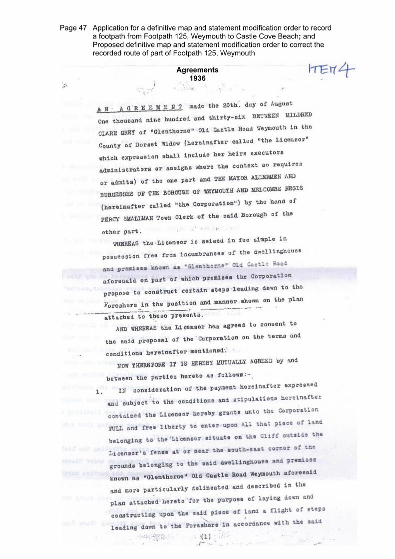
Page 47 Application for a definitive map and statement modification order to record a footpath from Footpath 125, Weymouth to Castle Cove Beach; and Proposed definitive map and statement modification order to correct the recorded route of part of Footpath 125, Weymouth
Agreements
1936

Page 48 Application for a definitive map and statement modification order to record a footpath from Footpath 125, Weymouth to Castle Cove Beach; and Proposed definitive map and statement modification order to correct the recorded route of part of Footpath 125, Weymouth

Page 49 Application for a definitive map and statement modification order to record a footpath from Footpath 125, Weymouth to Castle Cove Beach; and Proposed definitive map and statement modification order to correct the recorded route of part of Footpath 125, Weymouth

Page 50 Application for a definitive map and statement modification order to record a footpath from Footpath 125, Weymouth to Castle Cove Beach; and Proposed definitive map and statement modification order to correct the recorded route of part of Footpath 125, Weymouth

Page 51 Application for a definitive map and statement modification order to record a footpath from Footpath 125, Weymouth to Castle Cove Beach; and Proposed definitive map and statement modification order to correct the recorded route of part of Footpath 125, Weymouth
2009

Page 52 Application for a definitive map and statement modification order to record a footpath from Footpath 125, Weymouth to Castle Cove Beach; and Proposed definitive map and statement modification order to correct the recorded route of part of Footpath 125, Weymouth

Page 53 Application for a definitive map and statement modification order to record a footpath from Footpath 125, Weymouth to Castle Cove Beach; and Proposed definitive map and statement modification order to correct the recorded route of part of Footpath 125, Weymouth

Page 54 Application for a definitive map and statement modification order to record a footpath from Footpath 125, Weymouth to Castle Cove Beach; and Proposed definitive map and statement modification order to correct the recorded route of part of Footpath 125, Weymouth

Page 55 Application for a definitive map and statement modification order to record a footpath from Footpath 125, Weymouth to Castle Cove Beach; and Proposed definitive map and statement modification order to correct the recorded route of part of Footpath 125, Weymouth

Page 56 Application for a definitive map and statement modification order to record a footpath from Footpath 125, Weymouth to Castle Cove Beach; and Proposed definitive map and statement modification order to correct the recorded route of part of Footpath 125, Weymouth
2012

Page 57 Application for a definitive map and statement modification order to record a footpath from Footpath 125, Weymouth to Castle Cove Beach; and Proposed definitive map and statement modification order to correct the recorded route of part of Footpath 125, Weymouth

Page 58 Application for a definitive map and statement modification order to record a footpath from Footpath 125, Weymouth to Castle Cove Beach; and Proposed definitive map and statement modification order to correct the recorded route of part of Footpath 125, Weymouth

Page 59 Application for a definitive map and statement modification order to record a footpath from Footpath 125, Weymouth to Castle Cove Beach; and Proposed definitive map and statement modification order to correct the recorded route of part of Footpath 125, Weymouth
User Evidence
Table summarising user evidence from forms completed in 2014
NAME DATES FREQUENCY OF USE
TYPE OF USE
DETAILS OF USE / COMMENTS
Ms K Albin 2010 – 2014 20 – 50 times per year
Foot Used for pleasure. Others also used the route on foot. Not aware of any closures or diversions prior to the one currently in force (in 2014). ‘Please keep the beach clean and tidy’ sign present. Owner/occupier was aware of public access as they “created a lease to local council for stair access”. “Path from Old Castle Road to Castle Cove Beach has been part of the underbarn walk for many years with a separate step access. This metre wide strip of path and wooden constructed bridge lead to a set of one metre wide steps (now removed for reason unknown)”.
Ms Clare Alexander
1986 – present
(form filled out in 2014)
At least 50 times per
year
Foot Used for pleasure and work. Others also used the route on foot. ‘Footpath Closed’ sign and barrier on Underbarn Walk after the landslips. Believes owner was aware of public using the route as it has been used to access Castle Cove Beach which was “full of people in the summer”. Width of the path varied from approx 1m – 2m depending on the time of year and if vegetation had been cut back. Has used path and steps to access the beach, access the boat park (where own dingy and kayak were kept) and to take groups of school children to the beach (has been a teacher in Weymouth, Bridport and Dorchester for 28 years).
APPENDIX 4

Page 60 Application for a definitive map and statement modification order to record a footpath from Footpath 125, Weymouth to Castle Cove Beach; and Proposed definitive map and statement modification order to correct the recorded route of part of Footpath 125, Weymouth
NAME DATES FREQUENCY
OF USE TYPE OF
USE DETAILS OF USE / COMMENTS
Mrs J Barker 2009 – 2014 20 times approx per
year
Foot Used for pleasure. Others also used route on foot. Litter notice and Council water quality sign seen. Believes owner/occupier was aware of public usage as there was “no attempt to close it off”. Path approx. 1m wide. Vegetation at sides regularly cut back to allow access along a path that now only leads to steps/beach. When part of the SW coast path was closed due to cliff fall the path from the road to the beach remained open with signage, to the beach.
Mr M R Barker 2009 – 2014 20 times per year approx
Foot Used for pleasure Others also used route on foot. Litter notice and Council water quality sign seen. Believes owner/occupier was aware of public usage as there was “no action taken to close/obstruct path”. Path about 1 metre wide. “Local land charges search ref 2009/00383 shows path from Old Castle Road down to Castle Cove Beach as public right of way by being coloured same as roads/footpaths. Confirmed by recent phone call to Weymouth/Portland B.C. Land Charges office”.
Mrs S F Bentley 1953 – 2013 Frequently Foot Used for pleasure. Others also used route on foot. Frequently used the steps to the beach for leisure activities. Since late 1980’s when western end of Underbarn footpath was blocked by landslip, have also used the steps to walk to and from Weymouth along the beach and the eastern end of the Underbarn footpath.
Mr P Bickingham 1998 – 2013 18 times per year
Foot Used for pleasure. “Saw many people using the path and steps”. “The path is approximately 1 metre wide with a concrete/tarmac surface and wooden steps leading to the beach.”

Page 61 Application for a definitive map and statement modification order to record a footpath from Footpath 125, Weymouth to Castle Cove Beach; and Proposed definitive map and statement modification order to correct the recorded route of part of Footpath 125, Weymouth
NAME DATES FREQUENCY
OF USE TYPE OF
USE DETAILS OF USE / COMMENTS
Mr A G Bird 1974 – 1981 1992 – 2013
1974 – 1981 150 per year
1992 – 2013 30 – 50 per
year
Foot Used for to access beach for leisure activities. Others also used route on foot. Path approx. 1.5 metres wide – steps similar width. Great Grandparents and Grandparents lived locally and also used beach, but method of access to beach not specified.
Mrs D L Bird 1966 – 1971 1986 – 2013
1966 – 1971 12 – 20 times
per year
1986 – 2013 30 – 50 times
per year
Foot Used for pleasure. Others also used route on foot. Approx 1.5 metres wide. The steps were of similar width. Used beach with extended family including Grandparents post 1966
Mr R M Bird Before the war and
1947 – onwards
(form completed in 2014)
Many times a year
Foot Used for pleasure. Others also used route on foot. Used Sandsfoot Castle Beach for pleasure and swimming before and up to the war years, and after those years continued to go to the cove. Access route not specified but implied via steps on map.
S Bird 1945 onwards
(form completed in 2014)
During summer time
Foot Used for pleasure. Others also used route on foot. In mid 40’s would meet friends at the cove to play and swim. During school holidays would be there 2 or 3 times a day. Access route not specified but implied via steps on map.
Mrs T C Buckle 1960 – 2012 20 – 30 times per year
Foot Used for pleasure. Others also used route on foot. Believes owner/occupier was aware of public usage as a “great number” of people used the beach, which even had a café on it. Has used this path for 52 years; as a child, parent and grand parent.
Mrs B Budd From 1961 (Form
completed in 2014)
20 times per year approx
Foot Used for pleasure. Others also used route on foot. Believes owner/occupier was aware of public usage as “many families using beach”.

Page 62 Application for a definitive map and statement modification order to record a footpath from Footpath 125, Weymouth to Castle Cove Beach; and Proposed definitive map and statement modification order to correct the recorded route of part of Footpath 125, Weymouth
NAME DATES FREQUENCY
OF USE TYPE OF
USE DETAILS OF USE / COMMENTS
Mr J Budd From 1961 (form
completed in 2014)
More than 20 times per
year
Foot Used for pleasure. Others also used route on foot. Believes owner/occupier was aware of public usage as “there has been a regular flow of users during daylight hours”.
Mr R Burdett 1970 onwards
(form completed in 2014)
20 – 30 times per year
Foot Used for pleasure. Others also used the route on foot.
Ms J Burnet 1986 – 1998 80 times per year
Foot Used for pleasure. Others also used the route on foot. Believes owner/occupier was aware of public usage as “the beach was always busy and this was the only access during all the tides”.
Mr D Corps 1965 – 2013 10 – 15 times per year
Used for pleasure. Others also used route on foot. Believes owner/occupier was aware of public usage as it was used by many people and “would be difficult for owners to miss”. 6 feet wide.
Mr S Corps 1970 – not stated
20 times per year
Foot Used for pleasure. Others also used route on foot.
Mrs C A Cowlishaw
1997 – 2013 100 times per year
Foot Used for pleasure. Others also used route on foot. “grandchildren came by car”. Pick up litter notice seen. Footpath is approx 4-5 feet wide, it varies. Steps were of similar width. Beach has “always been well used & well loved by the public”.
Mr J R Cowlishaw 1997 – 2013 80 – 120 per year approx
Foot Used for pleasure. “Many, many” others also used route on foot. Notices present about litter and also general information notices about the beach. Often spoke to owner on beach as they collected litter. Path to steps about 5 feet, steps down about 4 feet. Beach enjoyed by “many families” and “busy in summer”. “No signs forbid my presence, in fact a notice told me of the structure and welcomed me”.

Page 63 Application for a definitive map and statement modification order to record a footpath from Footpath 125, Weymouth to Castle Cove Beach; and Proposed definitive map and statement modification order to correct the recorded route of part of Footpath 125, Weymouth
NAME DATES FREQUENCY
OF USE TYPE OF
USE DETAILS OF USE / COMMENTS
Mrs J Day 1965 – 2014 50 – 150 Foot Used for pleasure and sailing etc. Others also used the route on foot. Believes owner/occupier was aware of public usage as “the volume of public could not be unnoticed”. “The foot path about 1.5 metres wide, the steps a similar width”. Grandchildren learned to swim there as “it is a safe beach”.
Mr V A J Day 1938 – 2013 50 – 100 times approx
Foot Used for pleasure and sailing etc. Others also used the route on foot. Believes owner/occupier was aware of public usage as “the volume of people couldn’t be missed”. “The foot path is approx. 1.5 metres wide (about 5ft). The steps a similar width”.
Miss L Diment 2000 – present (form
completed in 2014)
20 – 30 Foot Used for pleasure and to access boat park. Others also used route on foot. Other obstructions marked as “yes” but not specified. Route approximately 1 metre wide, “narrower in some places and wider in others”. Used the path and steps to the beach frequently over the past 14 years. “Kept a boat and kayak at the boat park for 2 yrs and we have used the steps to go to the beach for a walk, playing with the children, picnics and sunbathing”.
Mr S P B Elsworth 1991 – 2013 50 – 100 times per
year
Foot Used for pleasure. Others also used route on foot. Believes owner/occupier was aware of public usage as “there were a lot of us”. “This footpath is about 1.5 metres wide (about 5 feet) and the steps are a similar width”. Used route to get to beach for swimming.

Page 64 Application for a definitive map and statement modification order to record a footpath from Footpath 125, Weymouth to Castle Cove Beach; and Proposed definitive map and statement modification order to correct the recorded route of part of Footpath 125, Weymouth
NAME DATES FREQUENCY
OF USE TYPE OF
USE DETAILS OF USE / COMMENTS
Mrs C Evans 1973 – 2011 26 times per year
Foot Used for pleasure. Many used route on foot “especially on summer days”. Steps obstructed during maintenance, and “since closed by council on safety grounds”. Believes owner/occupier was aware of public usage as “this path and steps were used constantly”. “Path and steps approximately 4ft wide”.
Mr D Evans 1973 – 2011 30 times per year
Foot Used for pleasure. Many “up to 100 on Summer days” used the route on foot. Route obstructed occasionally “when steps were in need of repair”, and “recently inaccessible as path closed by W&PBC”. Believes owner/occupier was aware of public usage as “route was in constant use”. Width approx 1.5 metres.
Mr D Eyles 2003 – 2014 12 + times per year
Foot Used for pleasure. Others also used route on foot “nearly every time I used it”. “Temporary barrier since 2013 – just moved it to one side”. Believes owner knew of public using the route as they had an “arrangement with Weymouth and Portland Council”. “The alternative route suggested (recommended) by the council from the other beach across slippery rocks and danger of incoming tides is considerably more dangerous than the path”.
Miss J Fodden 1984 – 2013 At least daily during
summer
Foot Used for pleasure. Others used the route on foot and also bike. Anything from 1 – 2 people to whole groups used this route. There was a landslip notice from mid 90s; ‘No entry’.

Page 65 Application for a definitive map and statement modification order to record a footpath from Footpath 125, Weymouth to Castle Cove Beach; and Proposed definitive map and statement modification order to correct the recorded route of part of Footpath 125, Weymouth
NAME DATES FREQUENCY
OF USE TYPE OF
USE DETAILS OF USE / COMMENTS
Mr S Fremantle 1979 – 2014 25 – 50 times per year
Foot Used for pleasure. “Many” others also used route on foot. Recently Path Closed, No Access signs seen. Believes owner/occupier was aware of public usage as “it is a clearly well used way to the beach”. “This has been an unhindered access path to the beach since 1979, to my knowledge. I have used it since my children were small and with infant grandchildren. The width was between 3 – 4 feet, I estimate”.
Mr K Gill 1949 – 1970 20 + times per year
Foot Used for pleasure. Others used the route on foot and on bicycle. Believes owner/occupier was aware of public usage as it was “obvious, they would see them”. Width approx 2 metres.
Mrs M Glover 1958 – 2012 Variable from 4 – 40 times per year
Foot Used for pleasure. Others also used the route on foot. Believes owner/occupier was aware of public usage as “it was an extremely popular beach, used by locals”. Has used the route via the path and wooden steps since the age of 5 in 1958. Son took part in sailing lessons in 1989; “there were so many people on the beach in those days, it was difficult for them to move out of the way” when they had to carry the boat to the water.

Page 66 Application for a definitive map and statement modification order to record a footpath from Footpath 125, Weymouth to Castle Cove Beach; and Proposed definitive map and statement modification order to correct the recorded route of part of Footpath 125, Weymouth
NAME DATES FREQUENCY
OF USE TYPE OF
USE DETAILS OF USE / COMMENTS
Mr R Glover 1949 – 2012 Variable between 4 – 60 times per year
Foot Used for pleasure and access to sailing. Others used the route on foot. The route of the Underbarn path changed after landslip years ago, but the way down to the beach remained the same. Believes owner/occupier was aware of public usage as “it was at the bottom of their garden!” Regularly used the beach from 1949 and accessed it via the steps. Father ran the tea cabin on the beach when Mr Glover was a teenager. Mr Glover also helped Harold Winzar (land owner at time?). When young reached beach “down the steps like everyone else. Later, after joining the sailing club, “I used the private steps on Harold Winzar’s land”. “There were 2 gates on Harold Winzar’s land with signs on stating they were private, but I was permitted to use these as I was involved with the club and had agreement from the owners”. Beach was very busy in Summer; “all these people gained access to the beach down the path and down the wooden steps”. Photo included showing steps in 1947.

Page 67 Application for a definitive map and statement modification order to record a footpath from Footpath 125, Weymouth to Castle Cove Beach; and Proposed definitive map and statement modification order to correct the recorded route of part of Footpath 125, Weymouth
NAME DATES FREQUENCY
OF USE TYPE OF
USE DETAILS OF USE / COMMENTS
Mr B Grant 1959 – 1961 1966 to present (from
completed in 2014)
Used route at weekends and on Wednesday evenings from May – September (this can be evidenced from the sailing club racing records)
Foot Used for pleasure. Others used the route on foot. “To the beach” notice seen. Believes owner/occupier was aware of public usage as “the owner lives within a few yards of the path”. “The path and steps are approx 3 feet wide. The steps have always been in place over this period until their removal in Jan 2014”. Was a member of Castle Cove Sailing Club from 1959, which was sited “within yards of the footpath and steps” until 2002. “Whilst we did have our own private access I frequently used the footpath and steps route as did many other members” “On a good summers day the beach would be crowded such that it would be difficult to manoeuvre the shore based dinghies and boat tenders from their storage into the water. This can be evidenced from family photos dating back to 1970”. “Ref sect 4 Who owns the land Prior to 1970 Royal British Legion 1971-2002 Castle Cove Sailing Club 2002 to date [Oct 2014] Commodores Row Trust”
Ms V Graves 2009 – 2013 80 – 100 times per year
Foot Used for pleasure. Others also used the route on foot; “virtually always saw at least one other person”. Notices about quality of the water seen. Believes owner/occupier was aware of public usage as “they would have seen the people”. Width of route and steps approximately 4 – 5 feet. Used route to get to beach “picnic with other people” etc. etc. and to walk around the next beach past Sandsfoot Castle.

Page 68 Application for a definitive map and statement modification order to record a footpath from Footpath 125, Weymouth to Castle Cove Beach; and Proposed definitive map and statement modification order to correct the recorded route of part of Footpath 125, Weymouth
NAME DATES FREQUENCY
OF USE TYPE OF
USE DETAILS OF USE / COMMENTS
B Harte 1993 – 2013 5 – 20 times per year
Foot Used for pleasure. Others also used the route on foot. ‘Footpath closed due to landslip’ sign seen. “Fence present not letting you past the steps going to the beach”.
S Hilliar 1970 – 1979 20 – 30 times per year approx
Foot Used for pleasure. Others used the route on foot. Believes owner/occupier was aware of public usage as “it was obvious – a busy path, especially in summer” Never enjoyed a private right; “it was open to all”. “This path was used constantly by locals mostly, to gain access to the beach”.
Mrs E Hirst 2007 every year after – until steps removal
(form completed in 2014)
20 – 25 times per year
Foot Used for pleasure. Others also used the path on foot; “on a sunny day dozens of adults & children used the way”. “One notice appeared after the beach was sold at auction saying the new owner was happy for the public to continue to enjoy use of the beach”. Also believes owner/occupier was aware of public usage as “access to the way is opposite the owners property & they must have seen many people using it over the years”. Regularly enjoyed visiting Castle Cove Beach with grandchildren “it is a lovely safe, clean, attractive facility” “especially for local people in summer when the town beach is so crowded”
Mrs L James 1977 – 1998
and
2005 – 2012
1977 – 1998 26 times per year and 2005 – 2012 6 times per year
Foot Used for pleasure. Others also used the route on foot. Believes owner/occupier was aware of public usage as the route “has been used by locals for generations”.

Page 69 Application for a definitive map and statement modification order to record a footpath from Footpath 125, Weymouth to Castle Cove Beach; and Proposed definitive map and statement modification order to correct the recorded route of part of Footpath 125, Weymouth
NAME DATES FREQUENCY
OF USE TYPE OF
USE DETAILS OF USE / COMMENTS
Mrs K Jeanes 1953 – 1964
Most days during the summer
Foot Used for pleasure. Others also used route on foot. “Beach regularly crowded with children and families during school holidays”. Believes owner/occupier was aware of public usage as “so many people used the steps & beach they must have known” There was also a shop “& deckchair hire place”. Steps were just “wide enough for two people to pass carrying buckets, spades etc.”
Mr T E King 2002 – 2014
104 Foot Used for pleasure and work. Others also used the route on foot. ‘Temporarily Closed’ seen. Underbarn path blocked by fallen trees behind ‘Clovelly’. Believes owner/occupier was aware of public usage as “it has been a footpath for as long as I have lived in Weymouth”. “Well defined path from road to steps”
Mr M E Lerpinere 1953 – 2004
and
2004 – present (form
completed in 2014)
50 times per year
Foot Used for pleasure. Others also used route on foot. “Route from Old Castle Road to beach in place until steps removed”. ‘No access to beach’ notice seen recently. “Width of access path from Old Castle Road is approx 1.5 metres. Earth movement meant access to top of steps was slightly narrowed but steps were untouched and secure still”.
Mrs B M Llewellyn 1995 – 2010
Various – most weeks in summer holidays
Foot Used for pleasure. Others also used route on foot; “the beach was always very busy, with most people using the steps”. Metal barrier present and ‘closure of Underbarn walk’ notice at top of steps. Believes owner/occupier was aware of public usage as “there was a kiosk selling food & drink”.

Page 70 Application for a definitive map and statement modification order to record a footpath from Footpath 125, Weymouth to Castle Cove Beach; and Proposed definitive map and statement modification order to correct the recorded route of part of Footpath 125, Weymouth
NAME DATES FREQUENCY
OF USE TYPE OF
USE DETAILS OF USE / COMMENTS
Mr P Long 1950 – 1960’s
Too numerous to count
Foot Used for pleasure. Others also used the route on foot. “We had free access to the beach via the wooden steps off Old Castle Road”. Has photographic evidence of parents and friends on beach from 1937 onwards.
Mrs J McCracken 1966 - 2009
Many Foot Used for pleasure. Others also used route on foot. Public footpath (green sign) present. Used the path to access the beach with own children and throughout childhood. “Approx width of path to steps to the beach is 1.5m”.
Mr A McKechnie 2006 - 2013
20 times per year approx
Foot Used for pleasure. Others also used route on foot. Some warnings about dangerous land seen.
Mrs P March 1948 and
1970 – 2012
40 times per year approx
Foot Used for pleasure and access to sailing. Others also used route on foot. No restriction of access until the path was closed and the steps removed. Walking access to the beach is important as “our dinghy is stored on the boat platform, prior to this we kept it on the beach with permission from Andrew Holland”. “Large numbers of people used the steps, sometimes had to queue to ascend or descend.” Grandchildren used “safe and sheltered beach” “often met friends from Wyke Primary School”
Ms H E Martin 1958 (with
parents) – to now (form filled out in
2014)
12 – 100 times per year (probably much more frequently summers of 1960 – 1980)
Foot Used for pleasure. Others also used route on foot; “in the summer easily 200 people on the beach”. Believes owner/occupier was aware of public usage as “it has always (my memory) been busily used as a public footpath”. Parents used footpath regularly before and after 1950.

Page 71 Application for a definitive map and statement modification order to record a footpath from Footpath 125, Weymouth to Castle Cove Beach; and Proposed definitive map and statement modification order to correct the recorded route of part of Footpath 125, Weymouth
NAME DATES FREQUENCY
OF USE TYPE OF
USE DETAILS OF USE / COMMENTS
Mr A Meech 1950 – 2012
10 – 90 times per year
Foot Used for pleasure. Others also used the route on foot. “Footpath is 1.5m wide with steps to beach (now removed) slightly less – allowing pedestrians access to sea shore in Portland Harbour. People visiting by sea cannot access Old Castle Road”
Mrs M E Meech 1960 – 2013
At least 100 times per year
Foot Used for pleasure. Others also used the route on foot. “The path is about 5 feet wide steps of a similar width”.
Mr K Metcalf Since 1981
(form completed in 2014)
Multiple Foot Used for pleasure. Others also used the route on foot. “Frequently the path / steps were used by many people, particularly during the summer months, so much so that there would be queue of people to get onto the steps at times”.
Mr & Mrs E J Mitchell 1939 – 2000
Frequently Foot Used for pleasure. Others also used the route. Notices present about landslides. Path not diverted until landslides.
Ms A M Neale 1998 – 2013
Approx 400 times per year (there and back)
Foot Used for pleasure. Others also used route on foot. Believes owner/occupier was aware of public usage as “the route and users were in full view of the owners”. Footpath and steps approximately 1 ½ metres wide. “I used the route to access the sea to paddle and to take my grandchildren swimming”.

Page 72 Application for a definitive map and statement modification order to record a footpath from Footpath 125, Weymouth to Castle Cove Beach; and Proposed definitive map and statement modification order to correct the recorded route of part of Footpath 125, Weymouth
NAME DATES FREQUENCY
OF USE TYPE OF
USE DETAILS OF USE / COMMENTS
Mr M Norrington 1963 – closure
Numerous but especially 1960/70s and 1990s
Foot Used for pleasure. Others also used the route on foot. ”I have used it [the route] freely but never had to obtain any right to use it”. “The path is about 4 feet wide (1.2 – 1.5m), down 4 or 5 long steps to a steeper flight of steps, across a wooden bridge, then up a short stretch of uneven tarmac and right to three flights of wooden steps down to the beach”. “I used the path to the beach as a child (1959-1975)” and “after 1980 with my family and their children up until closure”
Mr R A Painter 1965 –
closure of path and
steps
Between 4 and 40 times per year
Foot Used for pleasure. Others also used the route on foot. “I was an officer at the sailing club which owned land on the beach but never an employee”. “As a member of Castle Cove Sailing Club, the former owner of the land, I was aware that the land is private but had always understood that there was a public right of access”.
Mr J Palmer 1967 – not specified
Many Foot Used for pleasure. Others also used the route on foot. “We were on the [Sailing] Club committee for a while We kept out dinghy on the park at the bottom of the path”. There was a tea kiosk on the beach “a few yards from the bottom of the stairs” “I believe it was owned by Mary Winzar of Old Castle Road”. “There is no doubt whatsoever that the path was an ordinary route from beach to road well used by the general public and club members alike. The beach was and presumably still is a safe secure place for families and folk in general”.
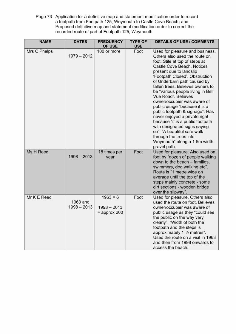
Page 73 Application for a definitive map and statement modification order to record a footpath from Footpath 125, Weymouth to Castle Cove Beach; and Proposed definitive map and statement modification order to correct the recorded route of part of Footpath 125, Weymouth
NAME DATES FREQUENCY
OF USE TYPE OF
USE DETAILS OF USE / COMMENTS
Mrs C Phelps 1979 – 2012
100 or more Foot Used for pleasure and business. Others also used the route on foot. Stile at top of steps at Castle Cove Beach. Notices present due to landslip ‘Footpath Closed’. Obstruction of Underbarn path caused by fallen trees. Believes owners to be “various people living in Bell Vue Road”. Believes owner/occupier was aware of public usage “because it is a public footpath & signage”. Has never enjoyed a private right because “it is a public footpath with designated signs saying so”. “A beautiful safe walk through the trees into Weymouth” along a 1.5m width gravel path.
Ms H Reed 1998 – 2013
18 times per year
Foot Used for pleasure. Also used on foot by “dozen of people walking down to the beach – families, swimmers, dog walking etc”. Route is “1 metre wide on average until the top of the steps mainly concrete - some dirt sections - wooden bridge over the slipway”.
Mr K E Reed 1963 and
1998 – 2013
1963 = 6
1998 – 2013 = approx 200
Foot Used for pleasure. Others also used the route on foot. Believes owner/occupier was aware of public usage as they “could see the public on the way very clearly”. “Width of both the footpath and the steps is approximately 1 ½ metres”. Used the route on a visit in 1963 and then from 1998 onwards to access the beach.

Page 74 Application for a definitive map and statement modification order to record a footpath from Footpath 125, Weymouth to Castle Cove Beach; and Proposed definitive map and statement modification order to correct the recorded route of part of Footpath 125, Weymouth
NAME DATES FREQUENCY
OF USE TYPE OF
USE DETAILS OF USE / COMMENTS
Ms H A Renson 1960 – 2013
Daily in the summer, weekly or less in winter
Foot Used for pleasure. Others also used the route on foot. Notices warning of subsidence seen. “No person has prevented me from using the steps but in 2013 it was blocked”. “The path and steps were wide enough for two people to walk side by side The steps were strong and safe”. Used the route to access the beach from 1960. Later own boat moored off the beach. Castle Cove Sailing Club slipway built under the original path’s bridge in 1988. Sailing Club put a memorial seat to Ms Renson’s mother at the base of the slipway. “were dismayed to find we couldn’t get down to the beach” to visit the memorial seat in 2013.
Mr M Sammeli 1989 – present (form
completed in 2014)
10 – 20 times per year
Foot Used for pleasure. Others also used the route on foot. Obstruction of Underbarn path caused by landslip. ”Nothing to suggest” that the owners/occupiers were not aware of the use of the route by the public.
Mrs S Shone 1962 – 1970
1997 – 2002
Weekly Foot Used for pleasure. Others also used the route on foot. “The path leads off/to the steps:- must be the same width as the steps”.
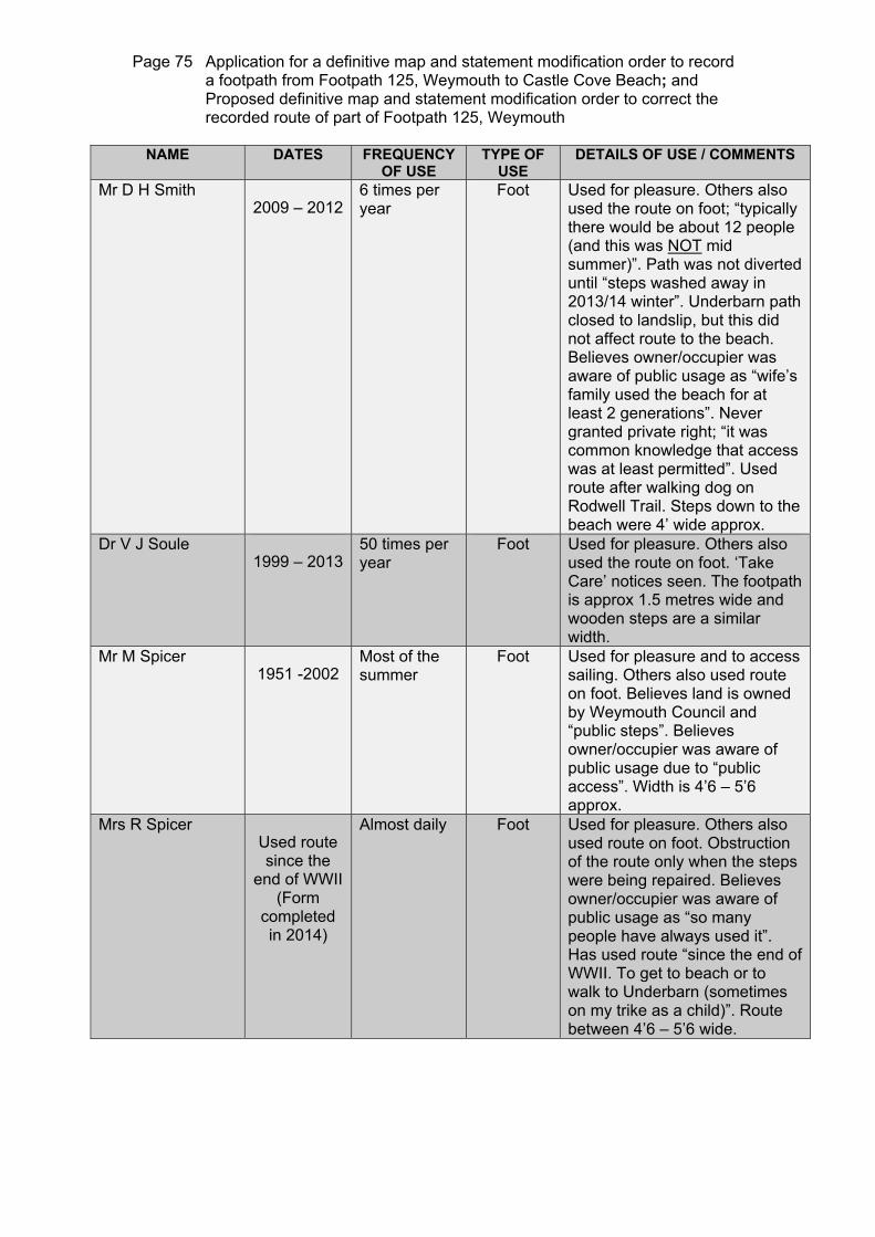
Page 75 Application for a definitive map and statement modification order to record a footpath from Footpath 125, Weymouth to Castle Cove Beach; and Proposed definitive map and statement modification order to correct the recorded route of part of Footpath 125, Weymouth
NAME DATES FREQUENCY
OF USE TYPE OF
USE DETAILS OF USE / COMMENTS
Mr D H Smith 2009 – 2012
6 times per year
Foot Used for pleasure. Others also used the route on foot; “typically there would be about 12 people (and this was NOT mid summer)”. Path was not diverted until “steps washed away in 2013/14 winter”. Underbarn path closed to landslip, but this did not affect route to the beach. Believes owner/occupier was aware of public usage as “wife’s family used the beach for at least 2 generations”. Never granted private right; “it was common knowledge that access was at least permitted”. Used route after walking dog on Rodwell Trail. Steps down to the beach were 4’ wide approx.
Dr V J Soule 1999 – 2013
50 times per year
Foot Used for pleasure. Others also used the route on foot. ‘Take Care’ notices seen. The footpath is approx 1.5 metres wide and wooden steps are a similar width.
Mr M Spicer 1951 -2002
Most of the summer
Foot Used for pleasure and to access sailing. Others also used route on foot. Believes land is owned by Weymouth Council and “public steps”. Believes owner/occupier was aware of public usage due to “public access”. Width is 4’6 – 5’6 approx.
Mrs R Spicer Used route since the
end of WWII (Form
completed in 2014)
Almost daily Foot Used for pleasure. Others also used route on foot. Obstruction of the route only when the steps were being repaired. Believes owner/occupier was aware of public usage as “so many people have always used it”. Has used route “since the end of WWII. To get to beach or to walk to Underbarn (sometimes on my trike as a child)”. Route between 4’6 – 5’6 wide.

Page 76 Application for a definitive map and statement modification order to record a footpath from Footpath 125, Weymouth to Castle Cove Beach; and Proposed definitive map and statement modification order to correct the recorded route of part of Footpath 125, Weymouth
NAME DATES FREQUENCY
OF USE TYPE OF
USE DETAILS OF USE / COMMENTS
Ms C L Sutton 1972 – 2012
Approx 4 but more 1979 – 1982
Foot Used for pleasure. Others also used the route on foot; “on a sunny summer’s day I have counted over 100 people down there” as “was thinking about reopening café in 2005”. “Access to Underbarn from top of steps was closed some years ago”. Believes steps were closed/removed for some time around 2007. No notices present until 2012. Believes areas of land are owned by Commodore’s Row, Boat Park is owned by Troy Goodfellow, and Glenthorne may also own some land. Believes owner/occupier was aware of public usage as “they could not fail to notice 100s of people using it each year”. “Depending on undergrowth, the path is about a metre wide, as is the little bridge (maybe a bit wider) and the steps.
Mr J S J Tawse During
1960’s and 1990’s
Regularly Foot Used for pleasure. Others also used the route on foot. Believes owner/occupier was aware of public usage as “it was used so much”.
Ms R Thompson 1956 – 2013
Daily in the summer until 1975 then weekly
Foot until 1975 then by car to
Old Castle Road
Used for pleasure. Others also used the route on foot. “Often went as a large family group & joined in many a sing along with Elim Church members called ‘Sunshine Corner’ and many locals and holiday makers”. Believes owner/occupier was aware of public usage as “it would have been hard to miss so many people using the path & steps”. Steps were about 3 – 4 feet wide, remembers having to stop quite often to let people pass or helping people down with stuff and small children, it was a very busy and popular beach.

Page 77 Application for a definitive map and statement modification order to record a footpath from Footpath 125, Weymouth to Castle Cove Beach; and Proposed definitive map and statement modification order to correct the recorded route of part of Footpath 125, Weymouth
NAME DATES FREQUENCY
OF USE TYPE OF
USE DETAILS OF USE / COMMENTS
Mrs M Trevett 1985- 2013
200 Foot Used for pleasure. Others also used route on foot. “The footpath is about 1.5metres wide (about five feet). The steps are of similar width. I went to the beach to walk along with dogs & children & also for swimming”.
Miss K Victoria 1974 – 1987
20 times per year
Foot Used for pleasure. Others also used the route on foot. Notice seen saying ‘Other path closed’.
Mrs J L Walker 2000 – 2011
Weekly Foot Used for pleasure. “Numerous” others also used the route on foot; “the beach was always busy”. Notice seen saying ‘Other path closed’. Believes owner/occupier was aware of public usage as “it was a public access to the beach”. Was disappointed that “following the landslide in 2011-2012 that I could no longer use the route to the beach”.
Mrs T Watling 1958 – 1963 1982 – 1990 2008 – 2013
6 times yearly approx
Foot Used for pleasure. Others also used the route on foot. “Always used as a safe beach for children. Path always maintained by cutting back bushes & shrubs & steps maintained too (presumably by Council). 3 – 4 ft width”.
Mr A C Webb 1953 – 1967
50 -100 times per year
Foot Used for pleasure. Others also used the route on foot; “often there were many people using the steps to access the beach”. Believes owner was aware of public using the route as “he encouraged the public to use his commercial facilities on the beach”. “Steps are probably about 4 feet”.

Page 78 Application for a definitive map and statement modification order to record a footpath from Footpath 125, Weymouth to Castle Cove Beach; and Proposed definitive map and statement modification order to correct the recorded route of part of Footpath 125, Weymouth
NAME DATES FREQUENCY
OF USE TYPE OF
USE DETAILS OF USE / COMMENTS
Mrs K Wheller 1950 - 2013
Weekly in early times. 20 times per year from 1998
Foot Used for pleasure. Others also used the route on foot. Route diverted when the Underbarn path collapsed – access via main road only. Climbed over landslip in 1960’s until cleared. “The footpath was about 5ft wide as were the steps. I used the paths and steps at least once a week from age 5 – 16 years and then at the least once a month until access was closed”.
Rev A J Whittock 1989 until recently
(form completed in 2014)
Everyday when had dog
Foot Used for pleasure. Others also used the route on foot. Notices about landslips appeared for health and safety reasons. Believes owner was aware of public using the route as “it was used heavily and signposted”. “From Old Castle Road it is 1m wide all the way down to the beach. The Underbarn walk had wider paths and narrower near the end. Landslips have obliterated this beautiful walk”.
Mr K Whittock 1989 – 2014
Almost everyday
Foot Used for pleasure. “Many others” also used the route on foot. Always ran over same route until Underbarn “was closed (partially) by landslips”. Subsequently saw notices warning of landslips. Believes owner was aware of public using the route as it was “used by all – frequently”. Path about a metre wide all the way to the beach

Page 79 Application for a definitive map and statement modification order to record a footpath from Footpath 125, Weymouth to Castle Cove Beach; and Proposed definitive map and statement modification order to correct the recorded route of part of Footpath 125, Weymouth
NAME DATES FREQUENCY
OF USE TYPE OF
USE DETAILS OF USE / COMMENTS
Mr B N Wilkins 1934 – 2013
Some years over 100 times
Foot Used for pleasure. Others also used the route on foot. “It was diverted for a short time when the Weymouth & Portland Council replaced the bridge”. “The footpath is about 5 feet wide & for most part there is an iron fence on each side that has been there since before the war & maintained by Weymouth and Portland Council as were the 3 flights of steps to the beach”.. Used the beach from a baby and including the war time when the beach was covered in barbed wire in case of a German invasion. Worked as a deck chair boy for pop Winzar; “he always told me that the beach was public and we could not stop the public from using their own chairs”. Mr Wilkins still used the beach over the last two years, but not the steps as the Council considered them dangerous.
Mrs J Wilkins 1942 – 2013
Almost every other day a year
Foot Used for pleasure. Others also used the route on foot. “The path and steps were looked after by Weymouth and Portland Council. My parents & grandmother used the beach before 1940”.

Page 80 Application for a definitive map and statement modification order to record a footpath from Footpath 125, Weymouth to Castle Cove Beach; and Proposed definitive map and statement modification order to correct the recorded route of part of Footpath 125, Weymouth
ALBINALEXANDERJ BARKERM BARKERBENTLEYBICKINGHAMA BIRDD BIRDR BIRD Before the war alsoS BIRDBUCKLEB BUDDJ BUDDBURDETT 1970 ONWARDS (FORM COMPLETED IN 2014)BURNETD CORPSS CORPS 1970 ONWARDS (FORM COMPLETED IN 2014)C COWLISHAWJ COWLISHAWJ DAYV DAYDIMENT 2000 ONWARDS (FORM COMPLETED IN 2014)ELSWORTHC EVANSD EVANSEYLESFODDENFREMANTLEGILLM GLOVERR GLOVERGRANT (FORM COMPLETED IN 2014)GRAVESHARTEHILLIARHIRST 2007 - Until steps removal (form completed in 2014)JAMESJEANES
1934
1935
1936
1937
1938
1939
1940
1941
1942
1943
1944
1945
1946
1947
1948
1949
1950
1951
1952
1953
1954
1955
1956
1957
1958
1959
1960
1961
1962
1963
1964
1965
1966
1967
1968
1969
1970
1971
1972
1973
1974
1975
1976
1977
1978
1979
1980
1981
1982
1983
1984
1985
1986
1987
1988
1989
1990
1991
1992
1993
1994
1995
1996
1997
1998
1999
2000
2001
2002
2003
2004
2005
2006
2007
2008
2009
2010
2011
2012
2013
2014
USED ON FOOT
Chart of user evidence to show periods of use
CONTINUED ON NEXT PAGE
YEARS OF USE
NAME

Page 81 Application for a definitive map and statement modification order to record a footpath from Footpath 125, Weymouth to Castle Cove Beach; and Proposed definitive map and statement modification order to correct the recorded route of part of Footpath 125, Weymouth
USED ON FOOT
KINGLERPINERELLEWELLYNLONG 1950's to 1960'sMCCRACKENMCKECHNIEMARCHMARTINA MEECHM MEECHMETCALF 1981 ONWARDS (FORM COMPLETED IN 2014)MITCHELLNEALENORRINGTON 1963 UNTIL CLOSURE OF PATH (FORM COMPLETED IN 2014)PAINTER 1965 UNTIL CLOSURE OF PATH AND STEPS (FORM COMPLETED IN 2014)PALMER END DATE NOT SPECIFIED (FORM COMPLETED IN 2014)PHELPSH REEDK REEDRENSONSAMMELI 1989 TO PRESENT (FORM COMPLETED IN 2014)SHONESMITHSOULEM SPICER R SPICER USED ROUTE SINCE THE END OF WWII (FORM COMPLETED 2014)SUTTONTAWSE DURING 1960's AND 1990'sTHOMPSONTREVETTVICTORIAWALKERWATLINGWEBBWHELLERA WHITTOCK 1989 until recently (form completed in 2014)K WHITTOCKB WILKINSJ WILKINS
1934
1935
1936
1937
1938
1939
1940
1941
1942
1943
1944
1945
1946
1947
1948
1949
1950
1951
1952
1953
1954
1955
1956
1957
1958
1959
1960
1961
1962
1963
1964
1965
1966
1967
1968
1969
1970
1971
1972
1973
1974
1975
1976
1977
1978
1979
1980
1981
1982
1983
1984
1985
1986
1987
1988
1989
1990
1991
1992
1993
1994
1995
1996
1997
1998
1999
2000
2001
2002
2003
2004
2005
2006
2007
2008
2009
2010
2011
2012
2013
2014
* Mr Painter’s use taken to be until 2013
YEARS OF USE
NAME

Page 82 Application for a definitive map and statement modification order to record a footpath from Footpath 125, Weymouth to Castle Cove Beach; and Proposed definitive map and statement modification order to correct the recorded route of part of Footpath 125, Weymouth
NUMBER OF USERS
6564636261605958575655545352515049484746454443424140393837363534333231302928272625242322212019181716151413121110987654321
1934
1935
1936
1937
1938
1939
1940
1941
1942
1943
1944
1945
1946
1947
1948
1949
1950
1951
1952
1953
1954
1955
1956
1957
1958
1959
1960
1961
1962
1963
1964
1965
1966
1967
1968
1969
1970
1971
1972
1973
1974
1975
1976
1977
1978
1979
1980
1981
1982
1983
1984
1985
1986
1987
1988
1989
1990
1991
1992
1993
1994
1995
1996
1997
1998
1999
2000
2001
2002
2003
2004
2005
2006
2007
2008
2009
2010
2011
2012
2013
2014
Chart to show level of use
YEARS OF USE