Embed Size (px)
Citation preview
THE GRAND BAHAMA PORT AUTHORITY, LIMITED
2014
REGULATIONS FOR TOWN PLANNING & DEVELOPMENT
1
THE GRAND BAHAMA PORT AUTHORITY, LIMITED REGULATIONS for PLANNING & DEVELOPMENT
ADMINISTRATIVE 1. Purpose 2. Jurisdiction 3. Administration 4. Function of Planning Section at Building & Development Services 5. Building Appearance Committee 6. Variances 7. Non-conforming lots 8. Building Permit Submissions 9. Professional Qualifications 10. Building Permit Fees
PLANNING REGULATIONS 11. Definitions 12. Restrictive Covenants contained in Deed Conveyances 13. Land owned by Private Developers 14. Flood Hazard Zones 15. Aquatic Zones 16. High water Table Zones 17. Coastal Zones 18. Projects requiring Environmental Review 19. Basic Zoning Districts 20. Innovative Residential Developments 21. Innovative Commercial Developments 22. Developments not accounted for in given zones 23. Temporary Uses 24. Temporary Housing 25. Off-Street Parking 26. On-site Storm Drainage 27. Driveway Access 28. Landscaping 29. Screening & Greening 30. Street Planting 31. Hedges, Fences, Boundary Walls 32. Population Densities 33. Setbacks 34. Minimum Room Size 35. Sewage Disposal 36. Repetitive Design 37. Lot Clearing and Grading and Cleaning
2
38. Waterway/Canal Protection 39. Pea rock Landscape Requirements 40. Density Control of Specific Types of Establishments 41. Docks, Piers and Jetties
PLANNING PROCEDURES
42. Procedures for Subdivision of Land within the Port Area 43. Procedures for Re-subdividing a Parcel within the Port Area 44. Procedures to Re-zone Land within the Port Area 45. Criteria for Granting Variances 46. Infrastructure Installation by Private Developers within the Port Area 47. Procedures for Demolition within the Port Area 48. Procedures for Paved Roads within the Port Area APPENDICES A. Demolition Permit Application
B. Building Permit Fees C. Environment Department Fee Structure
D. Guide for Building Permit Licences and Building Permit Applications requiring
Environmental Review
E. Flood Hazard Zone Maps
F. Engineer/Architect of Record

3
SUBDIVISION REQUIREMENTS See Building Code Supplement
4
ADMINISTRATIVE
1. PURPOSE OF THE REGULATIONS To provide rules, regulations, and standards to guide the development of land and structures thereon within the jurisdiction of The Grand Bahama Port Authority, Limited to promote public health, safety, organization, convenience, general aesthetics and general welfare.
2. JURISDICTION These Planning & Development Regulations apply to all areas within the administration of The Grand Bahama Port Authority, Limited. That is, all those areas referred to as The Port Area in the Hawksbill Creek Agreement dated 1955 and 1961. The regulations are subject to the Freeport Bye-Laws Act, Town Planning Act and Regulations and The Building and Sanitary Code.
3. ADMINISTRATION The administration of these regulations are to be carried out by the Planning Section of The Building & Development Services Department of The Grand Bahama Port Authority, Limited and The Building Appearance Committee; all headed by the Director of the Building & Development Services Department.
4. FUNCTION OF PLANNING SECTION To study and make recommendations on the short term and long term growth of the City of Freeport/Lucaya including all areas under the jurisdiction of The Grand Bahama Port Authority, Limited. To review site and location plans and special permit applications under zoning byelaws and site ordinances including deed conveyances – to control land use; to monitor land use. To issue building and related permits, to inspect all horizontal and vertical development on private and public properties to ensure compliance with applicable codes and regulations. To review and approve applications for subdivisions of land and to register the approved subdivisions. To review and approve applications for exterior signage and various methods of advertising throughout the City of Freeport/Lucaya.
5
To review the physical conditions of neighbourhoods, business communities, industrial sites for the purpose of making recommendations to Executive Management of The Grand Bahama Port Authority, Limited for required action. To review and approve plans for public and private roads, parks, recreational facilities and other physical spaces for use by the city’s residents. And to approve the various stages of development as construction progresses.
5. THE BUILDING APPEARANCE COMMITTEE
5-1.0 CLARIFICATION
1.0.1 The Building Appearance Committee was created by Resolution on March 1, 2012. The Building Appearance Committee is an advisory board authorized by The Grand Bahama Port Authority, Limited.
5-2.0 PURPOSE
2.0.1 To enhance the quality of the built environment within Freeport. This committee will be responsible for reviewing all newly proposed commercial, industrial and large residential improvement works and landscape plans; aesthetic changes to existing buildings and structures and other site works that exceed 5000 sq. ft. in area. In addition, this committee will be responsible for approving or disapproving location and positioning of various facilities (including vendor’s stalls) and their proximities to similar and dissimilar establishments.
5-3.0 RULES AND PROCEDURES
3.0.1 The Building Appearance Committee shall be governed by the regulations contained herein. For matters not covered by these rules and procedures, the Committee shall follow rules stated in the Grand Bahama Port Authority, Limited’s Building and Sanitary Code 2010. It shall comprise eight (8) members – four (4) standing and four (4) appointed.
5-4.0 MEETINGS
4.0.1 Meetings of the Appearance Committee shall be held at least every other month, but on an as needed basis. The meetings are to be held in the conference room of the Building & Development Services Department of The Grand Bahama Port Authority, Limited.
6
5-5.0 MEMBERSHIP AND TERMS OF OFFICE
5.0.1 Members must have backgrounds in at least one of the following areas of expertise: architecture, urban planning, economic planning and/or building construction/land development.
5.0.2 Appointed Members - The Grand Bahama Port Authority, Limited shall appoint one (1) representative to the committee. His/her expertise should be in the field of architecture. The Licencees of The Grand Bahama Port Authority, Limited shall appoint two (2) representatives to the committee with at least one member being an architect. The Freeport City Council shall appoint a qualified representative to sit on the committee. In the event that the Licencees or the City Council are not able to make the required appointment within the time specified, then The Grand Bahama Port Authority, Limited shall assume the responsibility of appointment.
5.0.3 Standing Members – The standing members shall be the director of
Building & Development Services; the manager of the City Management & Maintenance Department; a representative from the Business Development Department and the manager of the Planning Section of The Grand Bahama Port Authority, Limited.
5.0.4 Term of Office – The term of office for appointed members shall be two (2)
years. Vacancies occurring for reasons other than expiration of term shall be filled for the unexpired remainder of the term by the responsible appointers. New appointments are made in January of each year to fill expired terms.
5.0.5 Members of the serving committee shall recommend persons to GBPA to
serve on the committee for the following term.
5.0.6 Absence and Attendance – It shall be the duty of all committee members to inform the Secretary or Chairman of the Committee of any anticipated absence, and notification shall be immediately after receipt of the Agenda. Faithful attendance at meetings of the Building Appearance Committee is to be considered a prerequisite to continued membership. Any member missing three (3) consecutive meetings shall be removed. Absences due to sickness, death or other emergencies of like nature shall not affect the member’s status on the committee; except, that in the event of a long illness or other such case for prolonged absence, the member may be replaced.
5.0.7 Compensation – Members of the Committee shall serve without pay.
7
5-6.0 ORGANIZATION OF THE APPEARANCE COMMITTEE
6.0.1 The Building Appearance Committee, within thirty (30) days of its appointment, shall meet and elect a chairman and vice-chairman. The manager of the Planning Section of The Building & Development Services Department of The Grand Bahama Port Authority, Limited shall serve as secretary.
6.0.2 The Secretary shall be responsible for all correspondence necessary to the work of the Committee. The Secretary shall also keep an accurate account of minutes for each meeting, and must file a copy with the Building & Development Services Department of The Grand Bahama Port Authority, Limited no longer than ten (10) working days following the meeting.
6.0.3 Records – The Secretary shall maintain a record of committee members’
attendance, its discussions, its positioning, its actions, findings, and recommendations.
6.0.4 Voting – The voting of a majority of those present shall be sufficient to
decide any matter before the Committee provided a quorum is present.
6.0.5 Quorum - A quorum shall be formed when a minimum of 5 members are present.
5-7.0 DUTIES
7.0.1 Community Beautification – promote, and assist with guidance for the implementation of programs and projects for general community beautification.
7.0.2 Liaison – The Appearance Committee is a liaison between the Town
Planning Department and individuals, agencies, and organizations, public and private, whose plans, activities, and programs bear upon the appearance of the Town.
7.0.3 Leadership – Provide leadership and guidance in matters of community
designs and appearance to individuals, public and private organizations and agencies, based on Town Planning ordinances and regulations and the ‘Port Area’ Land Use Plans.
7.0.4 Responsible for the location and positioning of various facilities and its proximities to similar and dissimilar establishments, including but not limited to liquor stores, churches, petrol stations, preschools, etc.
8
7.0.5 Studies – Make studies of the visual characteristics of the Town, including surveys and inventories of an appropriate nature, and recommend standards and policies of design for the Town and any projects.
7.0.6 Recommend Amendments – Recommend to The Grand Bahama Port
Authority, Limited proposed amendments to ordinances that will serve to enhance the appearance of the Town. Recommend changes, additions, etc. to the Freeport Byelaws as they become necessary.
7.0.7 Assist in enforcement – Direct the attention of the Planning staff to needed
enforcement of any Town ordinance that in any way may affect the appearance of the Town.
7.0.8 Approval Required for Plans and Specifications – When and where
applicable, no structure shall be commenced, erected, placed, moved or permitted to remain on any Lot, nor shall any existing Structure upon any Lot be altered in any manner which materially changes the exterior appearance thereof, nor shall any new use be commenced on any Lot, unless plans and specifications (including a description of any proposed new use) shall have been submitted to and approved in writing by the Building & Development Services Department of The Grand Bahama Port Authority, Limited. Such plans and specifications shall be in such form and shall contain such information as may be required by the Planning Section, but in any event shall include (i) a site plan of the Lot or Lots, showing the nature, exterior color scheme, kind, shape, size, height, materials and location with respect to the particular Lot or Lots (including proposed front, rear and side setbacks) of all Structures, the location thereof with reference to Structures and adjoining portions of the Property, and the number and location of all parking spaces and driveways on the Lot or Lots; and (ii) a finished grade plan for the particular Lot or Lots. All commercial, industrial, institutional development required to have their relevant plans approved by the Building Appearance Committee. Hotels, places of assembly and residential buildings higher than two storeys also require the approval of the Building Appearance Committee. The committee shall have the right to require landscaping plans when it deems it necessary.
7.0.9 When an external project is submitted to the Building Appearance
Committee, the construction start and completion dates must be submitted with the plans for approval and must be adhered to within a reasonable timetable. Weather related disruptions can and will be taken into account within reason.
7.1 Disapproval of Plans and Specifications - The Building Appearance
Committee shall have the right to disapprove any plans and specifications submitted hereunder if there is
9
(A) failure of such plans or specifications to comply with any of the terms of this Declaration:
(B) failure to include information in such plans and specifications as may have been reasonably requested;
(C) objection to the exterior design, appearance or materials of any proposed Structure;
(D) incompatibility of any proposed Structure or use with existing Structure or uses upon other Lots in the vicinity;
(E) objection to the location of any proposed structure upon any Lot or with reference to other Lots in the vicinity;
(F) objection to the finished grade plan for any Lot;
(G) objection to the color scheme, finish, proportions, style of architecture, height, bulk or appropriateness of any proposed Structure;
(H) objection to parking areas proposed for any Lot on the grounds of (1) incompatibility to proposed uses and Structures on such Lot or (2) the insufficiency of the size of parking areas in relation to the proposed use of the Lot. The committee shall reserve the right to grant variances when such can be justified.
(I) objection to the plan for the drainage of water from the Lot onto adjacent Lots and/or Common Area; or
(J) any other matter which, in the judgment of the Building Appearance Committee, would render the proposed Structure, Structures or uses inharmonious with the general plan of improvement of the Property or with Structures or uses located upon the Lots in the vicinity.
7.1.2 In any case where the Building Appearance Committee shall disapprove any plans and specifications submitted hereunder, or shall approve the same only as modified or upon specified conditions, such disapproval or qualified approval shall be accompanied by a statement of the grounds upon which such action was based. In any such case, the Building Appearance Committee shall, if requested, make reasonable efforts to assist and advise the applicant in order that an acceptable proposal can be prepared and submitted for approval.
7.1.3 Any applicant shall have the right to request an audience with the committee to further present or defend the design submitted within a period of thirty days after notice has been sent advising of disapproval.
10
7.1.4 No member of the Committee, acting on behalf of the Committee, shall be
personally liable for any decision made by the Committee or any omissions made by the Committee.
7.1.5 Such decisions shall be tendered to the Committee to be recorded and
made effective at the following Committee meeting. 7.1.6 Retention of Approved Plans and Specifications - Upon approval by the
Building Appearance Committee of any plans and specifications submitted hereunder, a copy of such plans and specifications, as approved, shall be submitted to the Building & Development Services Department of The Grand Bahama Port Authority, Limited which at that time will be reviewed as stated in the Bahamas Building Code Third Edition-2003 1&2, and The Grand Bahama Port Authority, Limited’s corresponding supplement to the code.
7.1.7 Rules and Statements of Policy - The Building Appearance Committee
may promulgate rules governing the form and content of plans to be submitted for approval or requiring specific improvements on Lots, including, without limitations exterior lighting and planting, and may issue statements of policy with respect to approval or disapproval of the architectural styles or details, or other matters, which may be presented for approval. Such rules and such statements of policy may be amended or revoked by the Building Appearance Committee at any time, and no inclusion in omission from, or amendment of any such rules or statements shall be deemed to bind the Building Appearance Committee to approve or disapprove any feature or matter subject to approval or to waive the exercise of the Building Appearance Committee’s discretion as to any such matter, but no change of policy shall affect the finality of any approval granted prior to such change. Approval for use on any Lot of any plans or specifications shall not be deemed a waiver of the Building Appearance Committee’s right, in its discretion, to disapprove such plans or specifications or any of the features or elements included therein if such plans, specifications, features or elements are subsequently submitted for use on any other Lot or Lots. Approval of any such plans and specifications relating to any Lot, however, shall be final as to that Lot, and such approval may not be revoked or rescinded thereafter provided that (i) the Structures or uses shown or described on or in such plans and specifications do not violate any specific prohibition contained in this Declaration, and (ii) the plans and specifications, as approved, and any condition attached to any such approval, have been adhered to and complied with in regard to all Structures on and uses of the Lot in question.
11
7.1.8 In the event that the Building Appearance Committee fails to approve or disapprove any plans and specifications as therein provided within forty five (45) days after submission thereof, the same shall be deemed to have been approved, as submitted, and no further action shall be required.
7.1.9 Violation - If any Structure shall be altered, erected, placed or maintained upon any Lot, or any new use commenced on any Lot, otherwise than in accordance with plans and specifications approved by the Building Appearance Committee, such alteration, erection, maintenance or use shall be deemed to have been undertaken in violation and without the approval required herein, and, upon written notice from the Building Appearance Committee, any such Structure so altered, erected, placed or maintained upon any Lot in violation hereof shall be removed or re-altered, and any such use shall be terminated, so as to extinguish such violation.
7.2 If, fifteen (15) days after the notice of such a violation, the Owner of the Lot upon which such violation exists shall not have taken reasonable steps toward the removal or termination of the same, the Committee shall have the right, through the Grand Bahama Port Authority, Limited’s agents and employees, to enter upon such Lot and to take such steps as may be necessary to extinguish such violation, and The Grand Bahama Port Authority, Limited may recover any reasonable expenses incurred in so doing summarily as a civil debt from the owner or occupier in default and such person shall be guilty of an offence under these Regulations.
5-8.0 ANNUAL REPORT
8.1 The committee shall, no later than December 31st of each year, submit to the Director or Deputy Director of The Building & Development Services Department of The Grand Bahama Port Authority, Limited a written report of its activities.
5-9.0 AMENDING OR WAIVING RULES
9.1 These rules may be amended by a majority vote of the committee except where such amendment would be contrary to requirement or limitations set by law or local ordinance. An amendment may be proposed at any regular meeting of the Committee and shall not be acted upon until considered by The Grand Bahama Port Authority, Limited (and its Legal Department).
5-10.0 SECRECY CLAUSE
12
10.1 The Building Appearance Committee members shall not divulge to any person, firm or company any information in respect of the Committee’s business, or make use of any information acquired in their service as a Committee member, for his privilege or advantage.
6. VARIANCES
The purpose of a variance is to allow a modification to certain zoning regulations or resulting site conditions when such modification will not be contrary to the public interest when, owing to conditions peculiar to the property and not the result of the actions of the applicant, a literal enforcement of the regulation would result in unnecessary and undue hardship. Unnecessary and undue hardship may result from the size, shape or dimensions of a site; the location of existing structures on the site; geographic, topographic or physiographic features or other conditions on the site or in the immediate vicinity; or street locations or traffic conditions in the immediate vicinity. The Building Appearance Committee may use its discretion with respect to granting variances for public benefit where existing building structures together with land size could otherwise limit planning requirements. In granting a variance, the GBPA may prescribe appropriate conditions and safeguards which it finds necessary to protect the best interests of the surrounding property or vicinity and otherwise achieve the purpose of this code. Guarantees and evidence may be required that such conditions will be and are being complied with.
7. NON-CONFORMING LOTS, USES, STRUCTURES AND CHARACTERISTICS OF USES Within the zoning districts established by this code or amendments that may be adopted later, there exist lots, structures, uses of land or structures, and characteristics of uses which were lawful before this code was passed or amended, but which violate provisions of this code or future amendments. It is the intent of this code to permit these conformities to continue until they are removed, but not to allow their expansion or replacement.
13
8. BUILDING PERMIT SUBMISSIONS Approval from The Planning Section of The Building & Development Services Department of The Grand Bahama Port Authority, Limited is required before any portion of land within the city of Freeport/Lucaya or under the jurisdiction of The Grand Bahama Port Authority, Limited is altered.
Other approvals are also required in accordance with the applicable building code. All applications submitted for the purpose of obtaining approval from the Planning Section of The Building & Development Services Department of The Grand Bahama Port Authority, Limited must include
• A location plan • A site plan • Drawings of the building structure showing layouts, building sections and
building elevations and land and other horizontal elevations • Descriptions of the various functions of each structure and each land
area • Other as listed in The Grand Bahama Port Authority, Limited’s current
Building and Sanitary Code
All requirements as outlined in the Planning Requirements of this document must be satisfied. 8-1 Location Plan Sufficient information must be shown on location plans to clearly identify paths of access to the subject site from arterial and collector roads and any significant development on adjacent properties. It is expected that any inspector unfamiliar with the site should be able to find the site using the information given on the location plan. 8-2 Site Plan All developments shall be subject to site plan control. Plans must show all horizontal and vertical improvements proposed and all underground utilities. The scale of the drawings must be such, that they are easily legible, and to a scale not smaller than 1” in 20’-0”, except for conceptual drawings.
14
8-3 Building Structures Sufficient information must be shown on buildings and structures to clearly display the appearances of the building elevations and how the buildings and structures relate to each other and to physical movements which may surround the buildings and structures. The sizes and heights of each space and the function of each space must be specified. The authority has the right to request information on the types of building materials and specific colors being employed.
a. Scales of drawings submitted for exterior elevations of buildings shall be: 1/8” – 1’-0” or ¼” = 1’-0”; but for larger projects, the Director may use his discretion.
b. The Building & Development Services Department has the right to refuse examination of illegible drawings – unclear writing, printing, and confusing drawings.
8-4 Landscaping/Hardscaping A landscape/hardscape plan shall be required for
• All residential projects with more than six (6) dwelling units or with a floor area of 5,000 square feet or greater
• All commercial projects in the downtown area of Freeport
• All commercial projects whose land area is greater than ½ acre
• All industrial projects whose land area is greater than 1 ½ acres
• All civic developments whose land area is greater than 1 acre
Landscaping and Hardscaping plans must show sufficient information to identify all horizontal spaces of the site, and to specify the nature of the proposed finished state, plant species identification and planting details.
J. LOT SIZE No lot of land shall be smaller in size than the following: Urban Single Family Residential - 6,000 s.f. Rural Single Family Residential - 9,000 s.f. Duplex Residential - 9,000 s.f. Multi-family Residential - 10,000 s.f.

15
Hi-rise multi-family Residential - 14,000 s.f. In subdivisions which are specifically designed to accommodate innovative residential developments permission for smaller lot sizes will be considered.
16
9. PROFESSIONAL QUALIFICATIONS
9.1 All applications for building permits for new projects or renovations, additions, refurbishments, etc. of existing facilities shall be signed by and bear the impress of the seal of:
a) For works of an architectural nature – a licensed registered architect, except that licensed registered architectural technicians may take responsible charge (and sign and seal) for:
Works as specified in the Bahamas Professional Architect’s Act 1994 – Chapter 202 part VI section 30
I. A civic structure which is expected to exist in isolation, with
an area less than 1,000 square feet, or
II. The interior of a commercial and/or industrial facility with isolated floor area not to exceed l,000 square feet.
b) For engineering works – a licensed registered engineer whose discipline is in the relevant engineering field
c) For works of a specialist nature – a specialist whose specialty provides the necessary expertise and the specialist is licensed by The Grand Bahama Port Authority, Limited (GBPA) and recognized by the Director of the Building & Development Services Department of GBPA to do such work or oversee such work
Any plan submitted for final approval of a subdivision must be submitted under the responsibility of a licensed registered land surveyor and bear his/her signature and professional seal. A licensed registered architect or engineer means an architect or engineer registered as a professional architect or engineer by The Professional Architects Board or The Professional Engineers Board in the Commonwealth of The Bahamas and licensed by The Grand Bahama Port Authority, Limited. A licensed registered land surveyor is a land surveyor who is registered under the Land Surveyors Act 1975 and is licensed by The Grand Bahama Port Authority, Limited.
17
9.2 Engineer of Record/Architect of Record
An engineer of record is required for each discipline of an engineering project. This engineer is responsible for the design documents, based on the design he/she is assumed to have developed with specific expectations during the design and construction of the project. The engineer of record or architect of record must sign and seal all relevant drawings and documents submitted to the GBPA for the purpose of obtaining a building permit. He/she must also approve the construction works before a certificate of occupancy can be issued. (See Guidelines for Involvement of Engineer of Record in Appendix F)
10. Building Permit Fees See Appendix B – These fees are subject to change.
18
PLANNING REGULATIONS
11. DEFINITIONS
The following words, terms and phrases when used in this document shall have the meanings ascribed to them in this section. (When not inconsistent with the context, words used in the present tense include the future, words in the plural number include the singular, and words in the singular number include the plural. The word “shall” is always mandatory and not merely directory). “Accessory buildings”- a building/s constructed to complement the purpose of the principal building on a lot. “Drainage easements”- Where a subdivision is traversed by a water course, drainage way or canal, there shall be provided a storm water easement or drainage right-of-way conforming substantially with the lines of such water course, and further width or construction, or both, as will be adequate for the purpose. “Driveway”- a minor way providing vehicular access onto a private property or a public way providing vehicular access to house groups containing not more than eight houses. House groups containing more than 8 houses shall be served by a dead end street or cul-de-sac. “Duplex residential (zoning)/ duplex residence”- a dwelling having apartments with separate entrances for two families. “Final Plat”- The final tracing, map or drawing, or chart, on which the developer’s plan of subdivision is presented to GBPA for approval, and which, if approved, will be submitted to GBPA for recording. “Hi-rise multi-family residential”- Multi-family residential developments that allows an increase in the height restriction to permit more dwelling units per lot. “Industrial projects”- includes the development of light manufacturing, processing, repairs, and operations related to the supply of products. “Land subdivision”- is the act of dividing land into parcels. “Marginal Access Street”- a minor street that is parallel and adjacent to and exists from arterial streets for the purpose of providing access to abutting properties and protection from through traffic. “Minor road/street”-a street used primarily for access to abutting properties or in some cases a connecting street between subdivisions not adjoining.
19
“Multi-family residential (zoning)/ multi-family residence”- a classification of housing where multiple separate housing units for residential inhabitants are contained within one building or several buildings within one complex. “Preliminary Plat”- a preliminary map, sketch, drawing, or chart indicating to a reasonable degree the location and layout of the subdivision to be submitted for approval. “Property boundaries”- the limit or extent of the parcel or plot of land. “R.O.W. (right-of-way)”- the path or thoroughfare on which such passage is made. The strip of land designated for the development of roads, utilities infrastructure, landscaped medians and verges, sidewalks, bike paths etc. Building structures typically not permitted in the R.O.W. “Rural”- Of, relating to, or characteristic of the country (i.e. not the city area). Of or relating to land used as or designated for farming; and agricultural or other operations not likely located in urban areas. “Service streets or alleys areas”- a route directed to a designated area for vehicles to service the various businesses within a complex. Shall be reserved in commercial and industrial districts, except that the Agent may waive this requirement where other provision is made for service access and parking and is adequate for the uses proposed. “Setbacks”- the minimum distance from the property boundaries to the building/s. “Single family residential (zoning)/ single family residence”- a freestanding residential building meant to accommodate a single family unit, or to house one family: a private dwelling. “The authority” means The Grand Bahama Port Authority, Limited and its representatives. “Subdivisions”- a group of lots with planned infrastructure which are referred to under one area name. “Urban”- Of or located in the city. Characteristic of the city or city life “Utility easements”- Easements at least 8 feet wide across lots (not including drainage) and, where possible, centered on rear or side lot lines, shall be provided for utilities where necessary. “Variance”- an approval given with justification to deviate from the original requirements.
20
“Zones”- a planned area of land designated to accommodate a specific type of development.
12. RESTRICTIVE COVENANTS contained in DEED CONVEYANCE
All restrictions and stipulations contained in the covenants of land property deeds take precedence over other requirements in this document.
13. LAND OWNED BY PRIVATE DEVELOPERS Any tract of land or any subdivision whose developers collect service charges and maintains the physical area is categorized as being “Land owned by a private developer.”
All applications submitted to the Building & Development Services Department for a building permit must bear the sign and/or seal of approval by the private developer’s representative. The Director of the Building & Development Services Department may exercise his discretion in accepting such applications for review, examination and approval without a developer’s signature, but approval may only be given contingent upon the developer’s approval.
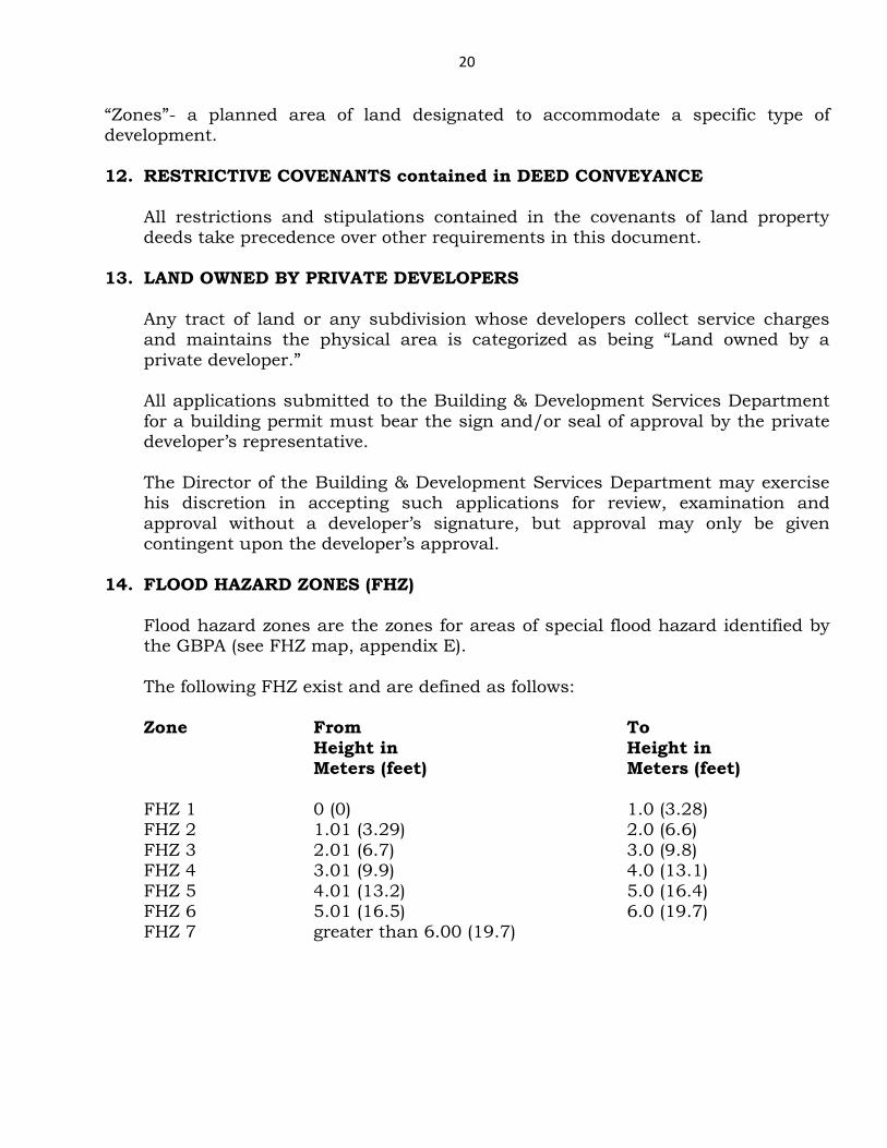
14. FLOOD HAZARD ZONES (FHZ)
Flood hazard zones are the zones for areas of special flood hazard identified by the GBPA (see FHZ map, appendix E).
The following FHZ exist and are defined as follows: Zone From To Height in Height in Meters (feet) Meters (feet) FHZ 1 0 (0) 1.0 (3.28) FHZ 2 1.01 (3.29) 2.0 (6.6) FHZ 3 2.01 (6.7) 3.0 (9.8) FHZ 4 3.01 (9.9) 4.0 (13.1) FHZ 5 4.01 (13.2) 5.0 (16.4) FHZ 6 5.01 (16.5) 6.0 (19.7) FHZ 7 greater than 6.00 (19.7)
21
15. AQUATIC ZONES (AZ) Aquatic zone is an area that is naturally under water and supports living and non-living systems, these zones maybe saltwater (marine/canal environments) or freshwater (ponds, swamps, wetlands) environs. All developments proposed for aquatic zones will require assessment by the Environmental Section of the Building & Development Services Department.
16. HIGH WATER TABLE ZONES (HWTZ)
Any land where the water table is less than 4’-0” below the original ground surface is considered to be a high water table zone (hwtz). Any development which requires the disposal of on-site sewage in the HWTZ will require assessment by the Environmental Section of B & D S. The Grand Bahama Utility Company reserves must approve all developments which affect the water table.
17. COASTAL ZONES (CZ) Any lot, plot or tract of land within a distance of fifteen hundred (1500) feet of any coastline is considered to be located in the coastal zone. Any coastal zone proned to experience storm surge must have its building envelop above the flood elevation.
18. PROJECTS REQUIRING ENVIRONMENTAL REVIEW
Project proposals which may impact directly or indirectly sensitive habitats and ecosystems and/or may significantly alter physical landscapes and ambient conditions of certain environs may require environmental review. Additionally, such projects which may irrevocably commit, degrade, or destroy any unique, limited or significant portion of any environmental resource. The environmental review process entails: the determination for and the evaluation of, an environmental statement or an environmental impact assessment/management plan(s) and/or construction drawings and details associated with the project. The review process also includes the inspection of the proposed location, and development (if necessary) of conditions to be attached to any permits granted. It may also require visits by environmental officials to similar sites or operations. See Appendix B and Appendix C
19. BASIC ZONING DISTRICTS
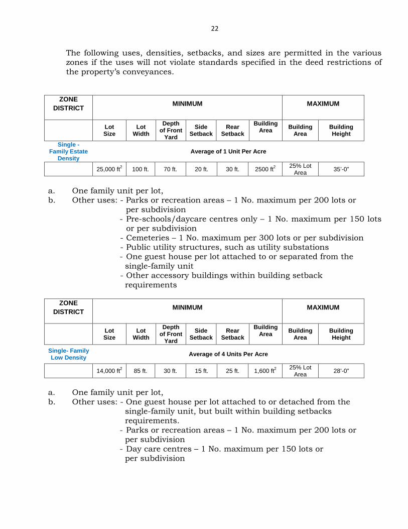
22
The following uses, densities, setbacks, and sizes are permitted in the various zones if the uses will not violate standards specified in the deed restrictions of the property’s conveyances.
ZONE DISTRICT MINIMUM MAXIMUM
Lot Size
Lot Width
Depth of Front
Yard Side
Setback Rear
Setback Building
Area
Building Area
Building Height
Single - Family Estate
Density Average of 1 Unit Per Acre
25,000 ft2 100 ft. 70 ft. 20 ft. 30 ft. 2500 ft2 25% Lot Area 35’-0”
a. One family unit per lot, b. Other uses: - Parks or recreation areas – 1 No. maximum per 200 lots or
per subdivision - Pre-schools/daycare centres only – 1 No. maximum per 150 lots
or per subdivision - Cemeteries – 1 No. maximum per 300 lots or per subdivision - Public utility structures, such as utility substations - One guest house per lot attached to or separated from the
single-family unit - Other accessory buildings within building setback
requirements
ZONE DISTRICT MINIMUM MAXIMUM
Lot Size
Lot Width
Depth of Front
Yard Side
Setback Rear
Setback Building
Area
Building Area
Building Height
Single- Family Low Density Average of 4 Units Per Acre
14,000 ft2 85 ft. 30 ft. 15 ft. 25 ft. 1,600 ft2 25% Lot Area 28’-0”
a. One family unit per lot, b. Other uses: - One guest house per lot attached to or detached from the single-family unit, but built within building setbacks requirements.
- Parks or recreation areas – 1 No. maximum per 200 lots or per subdivision
- Day care centres – 1 No. maximum per 150 lots or per subdivision
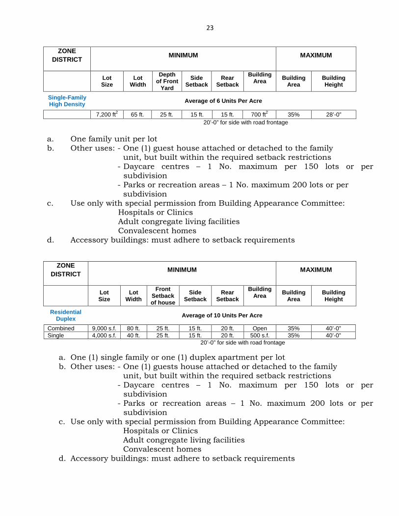
23
ZONE DISTRICT MINIMUM MAXIMUM
Lot Size
Lot Width
Depth of Front
Yard Side
Setback Rear
Setback Building
Area
Building Area
Building Height
Single-Family High Density Average of 6 Units Per Acre
7,200 ft2 65 ft. 25 ft. 15 ft. 15 ft. 700 ft2 35% 28’-0” 20’-0” for side with road frontage
a. One family unit per lot b. Other uses: - One (1) guest house attached or detached to the family
unit, but built within the required setback restrictions - Daycare centres – 1 No. maximum per 150 lots or per
subdivision - Parks or recreation areas – 1 No. maximum 200 lots or per
subdivision c. Use only with special permission from Building Appearance Committee:
Hospitals or Clinics Adult congregate living facilities Convalescent homes
d. Accessory buildings: must adhere to setback requirements
ZONE DISTRICT MINIMUM MAXIMUM
Lot Size
Lot Width
Front Setback of house
Side Setback
Rear Setback
Building Area
Building
Area Building Height
Residential Duplex Average of 10 Units Per Acre
Combined 9,000 s.f. 80 ft. 25 ft. 15 ft. 20 ft. Open 35% 40’-0” Single 4,000 s.f. 40 ft. 25 ft. 15 ft. 20 ft. 500 s.f. 35% 40’-0”
20’-0” for side with road frontage
a. One (1) single family or one (1) duplex apartment per lot b. Other uses: - One (1) guests house attached or detached to the family
unit, but built within the required setback restrictions - Daycare centres – 1 No. maximum per 150 lots or per
subdivision - Parks or recreation areas – 1 No. maximum 200 lots or per
subdivision c. Use only with special permission from Building Appearance Committee:
Hospitals or Clinics Adult congregate living facilities Convalescent homes
d. Accessory buildings: must adhere to setback requirements
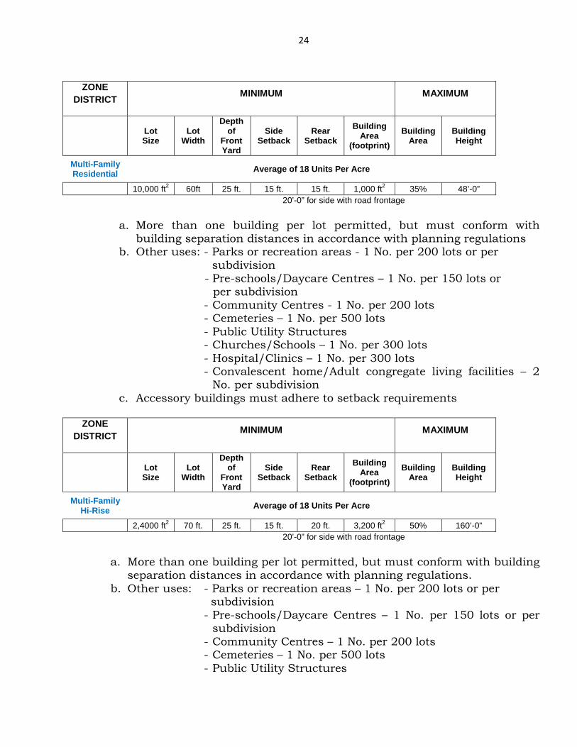
24
ZONE
DISTRICT MINIMUM MAXIMUM
Lot Size
Lot Width
Depth of
Front Yard
Side Setback
Rear Setback
Building Area
(footprint) Building
Area Building Height
Multi-Family Residential Average of 18 Units Per Acre
10,000 ft2 60ft 25 ft. 15 ft. 15 ft. 1,000 ft2 35% 48’-0” 20’-0” for side with road frontage
a. More than one building per lot permitted, but must conform with
building separation distances in accordance with planning regulations b. Other uses: - Parks or recreation areas - 1 No. per 200 lots or per
subdivision - Pre-schools/Daycare Centres – 1 No. per 150 lots or
per subdivision - Community Centres - 1 No. per 200 lots - Cemeteries – 1 No. per 500 lots - Public Utility Structures - Churches/Schools – 1 No. per 300 lots - Hospital/Clinics – 1 No. per 300 lots - Convalescent home/Adult congregate living facilities – 2
No. per subdivision c. Accessory buildings must adhere to setback requirements
ZONE
DISTRICT MINIMUM MAXIMUM
Lot Size
Lot Width
Depth of
Front Yard
Side Setback
Rear Setback
Building Area
(footprint) Building
Area Building Height
Multi-Family Hi-Rise Average of 18 Units Per Acre
2,4000 ft2 70 ft. 25 ft. 15 ft. 20 ft. 3,200 ft2 50% 160’-0” 20’-0” for side with road frontage
a. More than one building per lot permitted, but must conform with building
separation distances in accordance with planning regulations. b. Other uses: - Parks or recreation areas – 1 No. per 200 lots or per
subdivision - Pre-schools/Daycare Centres – 1 No. per 150 lots or per
subdivision - Community Centres – 1 No. per 200 lots - Cemeteries – 1 No. per 500 lots - Public Utility Structures

25
- Churches/Schools – 1 No. per 300 lots - Hospitals/Clinics – 1 No. per 300 lots - Convalescent homes/Adult congregate living facilities – 2
No. per subdivision c. Accessory buildings: must adhere to setback requirements
26
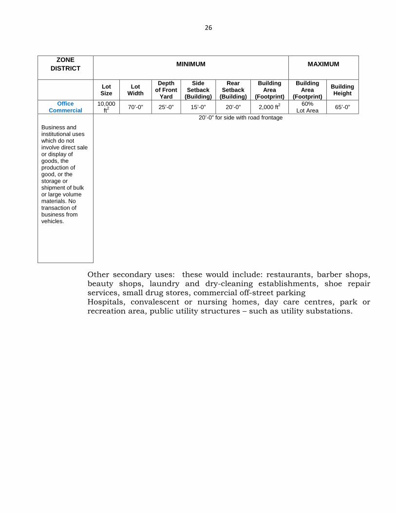
ZONE
DISTRICT MINIMUM MAXIMUM
Lot Size
Lot Width
Depth of Front
Yard
Side Setback
(Building)
Rear Setback
(Building)
Building Area
(Footprint)
Building Area
(Footprint) Building Height
Office Commercial
10,000 ft2 70’-0” 25’-0” 15’-0” 20’-0” 2,000 ft2 60%
Lot Area 65’-0”
Business and institutional uses which do not involve direct sale or display of goods, the production of good, or the storage or shipment of bulk or large volume materials. No transaction of business from vehicles.
20’-0” for side with road frontage
Other secondary uses: these would include: restaurants, barber shops, beauty shops, laundry and dry-cleaning establishments, shoe repair services, small drug stores, commercial off-street parking Hospitals, convalescent or nursing homes, day care centres, park or recreation area, public utility structures – such as utility substations.
27
ZONE DISTRICT MINIMUM MAXIMUM
Lot Size
Lot Width
Depth of Front
Yard
Side Setback
(Building)
Rear Setback
(Building)
Building Area
(Footprint)
Building Area
(Footprint) Building Height
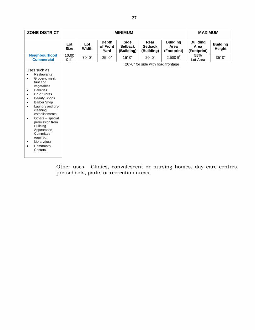
Neighbourhood Commercial
10,000 ft2 70’-0” 25’-0” 15’-0” 20’-0” 2,500 ft2 55%
Lot Area 35’-0”
Uses such as • Restaurants • Grocery, meat,
fruit and vegetables
• Bakeries • Drug Stores • Beauty Shops • Barber Shop • Laundry and dry-
cleaning establishments
• Others – special permission from Building Appearance Committee required.
• Library(ies) • Community
Centers
20’-0” for side with road frontage
Other uses: Clinics, convalescent or nursing homes, day care centres, pre-schools, parks or recreation areas.
28
ZONE DISTRICT MINIMUM MAXIMUM
Lot Size
Lot Width
Depth of Front
Yard
Side Setback
(Building)
Rear Setback
(Building)
Building Area
(Footprint)
Building Area
(Footprint) Building Height
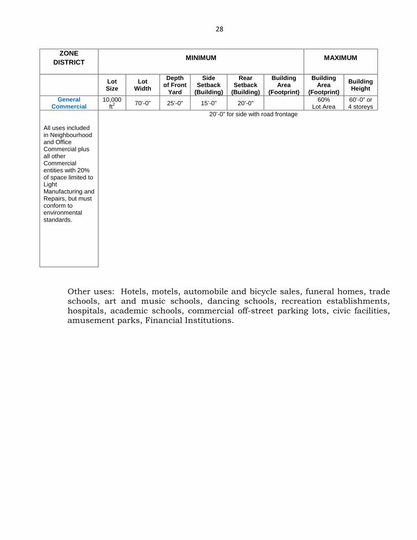
General Commercial
10,000 ft2 70’-0” 25’-0” 15’-0” 20’-0” 60%
Lot Area 60’-0” or 4 storeys
All uses included in Neighbourhood and Office Commercial plus all other Commercial entities with 20% of space limited to Light Manufacturing and Repairs, but must conform to environmental standards.
20’-0” for side with road frontage
Other uses: Hotels, motels, automobile and bicycle sales, funeral homes, trade schools, art and music schools, dancing schools, recreation establishments, hospitals, academic schools, commercial off-street parking lots, civic facilities, amusement parks, Financial Institutions.
29
ZONE DISTRICT MINIMUM MAXIMUM
Lot Size
Lot Width
Depth of Front
Yard
Side Setback
(Building)
Rear Setback
(Building)
Building Area
(Footprint)
Building Area
(Footprint) Building Height
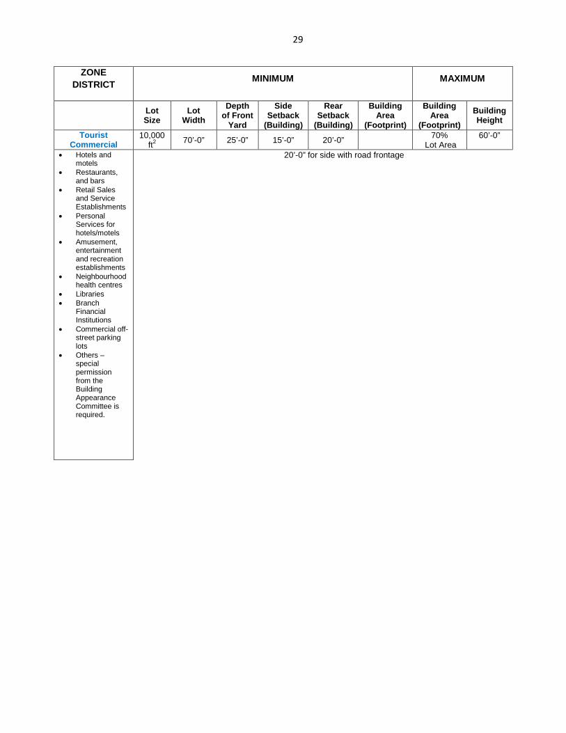
Tourist Commercial
10,000 ft2 70’-0” 25’-0” 15’-0” 20’-0” 70%
Lot Area 60’-0”
• Hotels and
motels • Restaurants,
and bars • Retail Sales
and Service Establishments
• Personal Services for hotels/motels
• Amusement, entertainment and recreation establishments
• Neighbourhood health centres
• Libraries • Branch
Financial Institutions
• Commercial off-street parking lots
• Others – special permission from the Building Appearance Committee is required.
20’-0” for side with road frontage
30
ZONE DISTRICT MINIMUM MAXIMUM
Lot Size
Lot Width
Depth of Front
Yard
Side Setback
(Building)
Rear Setback
(Building)
Building Area
(Footprint)
Building Area
(Footprint) Building Height
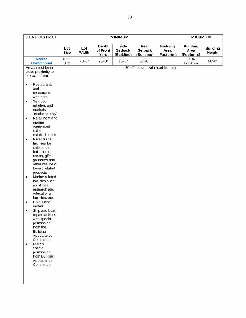
Marina Commercial
10,000 ft2 70’-0” 25’-0” 15’-0” 20’-0” 60%
Lot Area 60’-0”
Areas must be in close proximity to the waterfront.
• Restaurants
and restaurants with bars
• Seafood retailers and markets “enclosed only”
• Retail boat and marine equipment sales establishments
• Retail trade facilities for sale of ice, bait, tackle, charts, gifts, groceries and other marine or tourist related products
• Marine related facilities such as offices, research and educational facilities, etc.
• Hotels and motels
• Ship and boat repair facilities-with special permission from the Building Appearance Committee
• Others – special permission from Building Appearance Committee
20’-0” for side with road frontage
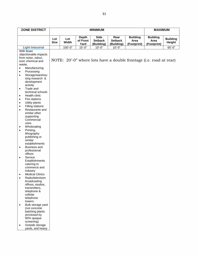
31
ZONE DISTRICT MINIMUM MAXIMUM
Lot Size
Lot Width
Depth of Front
Yard
Side Setback
(Building)
Rear Setback
(Building)
Building Area
(Footprint)
Building Area
(Footprint) Building Height
Light Industrial 100’-0” 15’-0” 10’-0” 10’-0” 65’-0” With fewer objectionable impacts from noise, odour, toxic chemical and waste, • Manufacturing • Processing • Storage/warehou
sing research & development activity
• Trade and technical schools
• Health clinic • Fire stations • Utility plants • Filling stations • Restaurants and
similar other supporting Commercial uses.
• Wholesaling • Printing,
lithography publishing or similar establishments
• Business and professional offices
• Service Establishments catering to commerce and industry
• Medical Clinics • Radio/television
broadcasting offices, studios, transmitters, telephone & cellular telephone towers.
• Bulk storage yard (not concrete batching plants (enclosed by 90% opaque screening)
• Outside storage yards, and heavy
NOTE: 20’-0” where lots have a double frontage (i.e. road at rear)
32
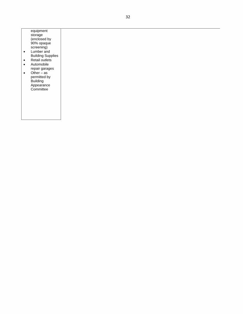
equipment storage (enclosed by 90% opaque screening)
• Lumber and Building Supplies
• Retail outlets • Automobile
repair garages • Other – as
permitted by Building Appearance Committee
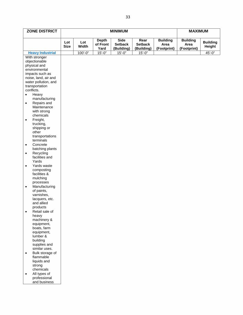
33
ZONE DISTRICT MINIMUM MAXIMUM
Lot Size
Lot Width
Depth of Front
Yard
Side Setback
(Building)
Rear Setback
(Building)
Building Area
(Footprint)
Building Area
(Footprint) Building Height
Heavy Industrial 100’-0” 15’-0” 15’-0” 15’-0” 45’-0” With stronger objectionable physical and environmental impacts such as noise, land, air and water pollution, and transportation conflicts. • Heavy
manufacturing • Repairs and
Maintenance with strong chemicals
• Freight, trucking, shipping or other transportations terminals
• Concrete batching plants
• Recycling facilities and Yards
• Yards waste composting facilities & mulching processes
• Manufacturing of paints, varnishes, lacquers, etc. and allied products
• Retail sale of heavy machinery & equipment, boats, farm equipment, lumber & building supplies and similar uses.
• Bulk storage of flammable liquids and strong chemicals
• All types of professional and business

34
offices • Petroleum
refining • Sanitary landfills
and construction and demolition debris landfill
• Essential services, including water, sewer, gas, telephone, radio and electric
• Hazardous waste transfer stations
• Storage and Manufacturing of Explosives
• Others – as permitted by Building Appearance Committee
35
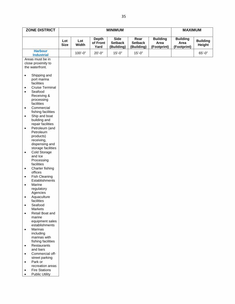
ZONE DISTRICT MINIMUM MAXIMUM
Lot Size
Lot Width
Depth of Front
Yard
Side Setback
(Building)
Rear Setback
(Building)
Building Area
(Footprint)
Building Area
(Footprint) Building Height
Harbour Industrial 100’-0” 20’-0“ 15’-0” 15’-0” 65’-0”
Areas must be in close proximity to the waterfront.
• Shipping and
port marina facilities
• Cruise Terminal • Seafood
Receiving & processing facilities
• Commercial fishing facilities
• Ship and boat building and repair facilities
• Petroleum (and Petroleum products) receiving, dispensing and storage facilities
• Cold Storage and Ice Processing facilities
• Charter fishing offices
• Fish Cleaning Establishments
• Marine regulatory Agencies
• Aquaculture facilities
• Seafood Markets
• Retail Boat and marine equipment sales establishments
• Marinas including marinas with fishing facilities
• Restaurants and bars
• Commercial off-street parking
• Park or recreation areas
• Fire Stations • Public Utility
36
Structures • Business,
communication, finance and Professional Services
ZONE DISTRICT MINIMUM MAXIMUM
Lot Size
Lot Width
Depth of Front
Yard
Side Setback
(Building)
Rear Setback
(Building)
Building Area
(Footprint)
Building Area
(Footprint) Building Height
General and Recreational Open Space
100’-0” 25’-0” 22’-0” 20’-0” 40% 35’-0”
• Park or
recreational Areas
• Indoor amusement, entertainment and/or recreation establishment
• Restaurants • Gift Shops • Cemeteries • Marinas, • Community
buildings • Amphitheaters
and museums • Public Utility
Structures • Other – special
permission from Building Appearance Committee required.
37
20. INNOVATIVE RESIDENTIAL DEVELOPMENTS
Innovative residential developments are developments which achieve a more creative and imaginative housing environment then normally occurs by use of the clustering technique, by employing various other methods to achieve distinctiveness and excellence in siting, design and/or landscaping. Density bonuses and reductions in various building restrictions are used to encourage these developments. Applicants are encouraged to apply for “approval in principle” as early as possible after the conceptual drawings have been produced. 21. INNOVATIVE COMMERCIAL DEVELOPMENTS Innovative commercial developments are developments which achieve a more creative and imaginative physical environment than normally occurs by use of the clustering techniques, by employing various other methods to achieve distinctiveness and excellence in siting, design and/or landscaping. Density bonuses and reductions in various building restrictions are used to encourage these developments. Applicants are encouraged to apply for “approval in principle” as early as possible after the conceptual drawings have been produced. 22. DEVELOPMENTS not accounted for within the GIVEN ZONES Any type of development not accounted for in these regulations would require approval by the Building Appearance Committee and the director of Building & Development Services for the suitability of a particular zoning District. 23. TEMPORARY USES
The following Temporary Uses will be allowed once a building permit has been issued/released. Permission given for temporary usage becomes null and void one month after final inspections of a permitted project or after six months of in-activity of the permitted project. Temporary buildings must satisfy the requirements and restrictions of the relevant subdivision. (a) Temporary building or yard for construction offices, material storage and equipment on the construction site with adequately equipped sanitary facilities. (b) A real estate sales office used for the sale of lots or housing units in a development, provided such office is in or adjacent to the development and is adequately equipped with sanitary facilities. The use must not generate excessive traffic congestion on nearby streets, nor vehicular parking problems, nor any objective nuisance nor hazardous features.
38
24. TEMPORARY HOUSING
Temporary housing for households displaced from their residences due to hurricanes, fires, floods or other disasters is permitted. However, only the Building Appearance Committee or GBPA Management may select the locations and determine the type of temporary housing. This temporary housing is only permitted if adequate sanitary facilities are supplied – and GBPA is satisfied with the relevant construction plans and documents which are to be submitted for approval. 25. OFF STREET PARKING
Off- street parking shall be required for all applications in accordance with the following schedule:
All Residential Buildings 2 parking spaces for the first two units
and 1.25 parking spaces per unit thereafter
Schools 2 parking spaces per member of faculty
or each classroom, which ever is greater
Offices of Doctors, Dentists 5 parking spaces for each practitioner
Offices 1 parking space for every 350 sq. ft. of office gross floor area (ratio 1:1). One additional taxi space to be provided for every 50 parking spaces calculated under this standard. 1 handicap parking for the first 30 parking spaces, and 1 for every 50 spaces thereafter
Places of Assembly 1 parking space for every 3 seats. One
additional taxi parking space to be provided for every 50 parking spaces calculated under this standard. 1 handicap parking for the first 30 parking spaces, and 1 for every 50 spaces thereafter
39
Employee Parking 1 space per 3 employees other than professional
Restaurants 1 parking space for every 6 seats. One
additional taxi parking space to be provided for every 30 parking spaces calculated under this standard. 1 handicap parking for the first 30 parking spaces, and 1 for every 50 spaces thereafter
Retail Establishments 1 parking space for every 175 sq. ft. of
retail gross floor area (ratio 1:2). One additional taxi parking space to be provided for every 30 parking spaces calculated under this standard. 1 handicap parking for the first 30 parking spaces, and 1 for every 50 spaces thereafter
Hotels, Motel, Tourist Courts 1 parking space per sleeping room for the
first 50 rooms- 1 parking space per 4 sleeping rooms thereafter. One additional taxi parking space to be provided for every 30 parking spaces calculated under this standard. 1 handicap parking for the first 30 parking spaces, and 1 for every 50 spaces thereafter
Warehouse & Storage 1 parking space for every 500 sq. ft of
floor space Facilities 1 handicap parking for the first 30
parking spaces, and 1 for every 50 spaces thereafter
All Other Buildings On application
40
In calculating the number of spaces, fractions must be taken to the next highest whole number. (For the purpose of this clause the gross area of a parking space shall be assumed to be 350 square feet.)
The frontage along the entire parking area adjacent to the street shall be curbed, walled or landscaped, excepting only entrances, exits or drainage outlets.
All commercial and industrial parking shall meet the active use and architectural screening requirements in Section 29.0. DRIVEWAY ACCESS TO STREETS
Driveway access from all parking spaces and areas shall be required. The driveway width shall be no greater than 10’-0”, nor less than 13’-0” in width for one-way access or 20’-0”, nor less than 25’-0” for two-way access. The frequency of access points onto an adjacent street and distance of a driveway access from an intersection shall be in accordance with the following schedule: Arterial Road ……..80 ft. minimum from an intersection or centre to centre Collector Street……60 ft. minimum from an intersection or centre to centre Minor Street……….30 ft. minimum from an intersection or centre to centre No site shall be allowed more than 2 Exits/ Entrances unless specifically reviewed and approved by The Grand Bahama Port Authority, Limited’s Building & Development Services Department 26. ON SITE STORM DRAINAGE All site drainage must occur on site. Drainage into adjacent roads or neighbouring properties is not permitted.
27. DRIVEWAY ACCESS
A driveway constructed with a pea-rock surface must be built such that the pea-rock is contained with a level surface. These driveways are only permitted for use in urban and rural single family developments. 28. LANDSCAPING
Natural features shall be retained where possible unless just cause can be given for their removal. No trees of over 3” caliper (measured at the base) shrubs or flowering plants shall be removed unless they encumber the construction of the buildings or unless full scale landscaping is proposed for the development immediately on completion of the building. All building sites must be fully landscaped before a Certificate of Occupancy will be issued. Where underground utilities have been
41
installed in the R.O.W. it is strongly recommended that an exercise be carried out to locate Utilities to avoid damage. For developments whose improvements cost total $300,000.00 or more require landscape plans. Such development should be guided by the landscape manual produced by The Grand Bahama Port Authority, Limited. The Landscape Manual The Town Planning and Environmental Section of the Building & Development Services Department in coherence with the Building Appearance Committee shall prepare a landscape manual and make the same available to the public. The landscape manual shall be adopted by resolution of The Grand Bahama Port Authority, Limited’s Bye-Laws. Said manual shall provide illustrative interpretations of the standards provided herein and suggested guides for landscaping in accordance with the above standards. Artificial Turf – special permission must be requested. A site layout of the landscaping and hardscaping must be submitted for assessment. Not more than 40% of the landscaped area in each segment of a site may accommodate artificial turf. Due to the required maintenance, approval will only be granted with on a case by case basis, with conditions attached.
• Landscaped areas should be incorporated into the planning of each individual site (unpaved landscaped areas will result in less runoff).
• The integration of native vegetation into the landscaping will reduce the need for irrigation, fertilizers and pesticides (examples of some native vegetation include: Silver Buttonwood (Conocarpus sericeus), Lignum Vitae (Guaiacum sanctum), Mahogany (Sweitenia mahogani), Silver Palm (Coccothrinax argentata), Hog Cabbage Palm (Pseudophoenix sargentii) or Sea Grape (Coccoloba uvifera), or consult a local nursery for more options).
• The following invasive species of plants should be eliminated from individual properties and should not be planted or permitted to remain within areas for immediate permitted development: Brazilian pepper, Bahamian Holly (Schinus terebinthifolius) Melaleuca (Melaleuxa quinquenerva) Asian Scaevola, White Inkberry (Scaevola taccada) Seaside mahoe (Hibiscus tiliaceas) Australian pine (Casuarina equisetifolia)
• Landscape waste (i.e. tree limbs, grass clippings etc.) should be composted and re-used as a fertilizer source. Otherwise landscape waste should be disposed of in an appropriately deemed dump site or the Pineridge Landfill.
29. SCREENING & GREENING
42
Trash Enclosures All trash enclosures for commercial developments shall include fully opaque screening gates, finished and painted to match the enclosure. Screening gates shall not open directly into vehicular drive aisles. Trash enclosures are not required in industrial districts if located inside an enclosed yard which is screened by a perimeter wall at least 6 feet in height. Unsightly Sites To guard against unsightly and offensive yards, any and all unsightly areas should be enclosed with opaque fencing – at residential, commercial, high visibility will require more stringent aesthetics. Screening of Roof Mounted Mechanical Equipment a) Roof-mounted mechanical equipment shall be fully screened by either one of the
following methods:
i. The parapet wall of the building shall equal or exceed the height of the mechanical units, within a horizontal distance of 300 feet along adjacent grade, or:
ii. By locating the mechanical equipment behind the roof planes in the case of mansard, hip or other than flat roof.
Roof mounted mechanical equipment enclosures or equipment screen walls shall not project above the roof parapet. To the extent permitted by law, satellite dishes shall be fully screened by a parapet wall. Minor features not exceeding one foot in height shall be exempted from this regulation. Ground mounted mechanical equipment shall be fully screened from view (from streets or surrounding commercial uses) by combination of decorative walls and an evergreen vegetative hedge equal to or exceeding the height of the equipment.
Screening of Parking Lots, Service Entries and Residential Property Boundaries
1) Off-street parking and “vehicle use areas” adjacent to the public right-of-way shall be screened as provided in this Section.
2) Depending on the development of any residential, commercial or industrial site, the Director of The Building & Development Services Department of The
43
Grand Bahama Port Authority, Limited may insist that property boundary areas adjacent to arterial and collector roads shall be screened from view by evergreen shrubs, opaque fencing or solid building walls.
Perimeter Screening Service areas for commercial buildings shall provide a screening feature around the perimeter of the lot adjacent to the public right-of-way. Screening shall add to the visual diversity of the use and need not be an opaque barrier. The Director of The Building & Development Services Department of The Grand Bahama Port Authority, Limited is authorized to modify the requirements of subsection thereby allowing alternative landscape treatments to partially or wholly satisfy this screening requirement provided that alterative landscape treatments such as landscaped berms, perimeter planting, pedestrian lighting, benches and seating areas, or additional landscaping and tree planting are provided elsewhere on the site and will be visible from the public right-of-way or are provided in the public right-of-way. The Director may authorize such modification only upon finding that the proposed alternative landscape treatment would:
1) Provide a visual effect that promotes and enhances the pedestrian experience through the use of quality urban design;
2) Promote the reduction of storm water runoff through the most natural means
3) Use climate appropriate plant materials 30. STREET PLANTING Any plant material installed within the verges or medians require approval from the Planning Section of the Building & Development Services Department. 31. HEDGES, FENCES, BOUNDARY WALLS No fence or boundary wall may be constructed without written approval of the Building & Development Services Department of The Grand Bahama Port Authority, Limited, and no hedge, fence or boundary wall shall be installed within 20’ of a road intersection edge of more than 3 feet in height. 32. POPULATION DENSITIES
In all subdivisions in Freeport and Lucaya, the density of development shall not exceed the following:
44
a) Density of 24 persons per acre for single storey buildings unless otherwise stated in the subdivisions deed restrictions, or as dictated by Building set -backs and parking requirements, or other building code requirements.
33. SETBACKS
Setbacks shall vary with the type of buildings and the area for which the building is to be constructed. The following is a general listing of the required setbacks and spaces between buildings. The developer must also consult the Deed, Lease and Subdivision Restrictions. In case of a conflict, the higher standard shall apply. 34. MINIMUM ROOM SIZE
The following schedule lists the minimum room sizes allowable for domestic premises: Living Rooms 160 sq. ft. Dining Rooms 80 sq. ft. (190 sq. ft. if combined with Living Room) Kitchen 60 sq. ft. (100 sq. ft. if combined with Dining Room) First Bedroom 120 sq. ft. Other Bedrooms 90 sq. ft. Living, dining, kitchen & bedroom (efficiency apartment only) 250 sq. ft. The ceiling height shall be 8’-0” minimum average with a 7’-0” absolute minimum to all habitable rooms. See also Part III of The Bahamas Building Code – Third Edition – 2003 – Part 1 Higher Standards are accepted. 35. SEWAGE DISPOSAL
All buildings within the Port Area shall obtain permission from The Grand Bahama Utility Company (Water Dept.) on the proposed manner of sewage disposal. 35.1 MARINA SEWAGE DISPOSAL All marinas are required to have a pump out sewage station to service the vessels. 36. REPETITIVE DESIGN AND SAME TYPE BUSINESSES
45
Not more than six (6) buildings may be constructed from any one set of plans in any area unless prior approval in writing is obtained from The Grand Bahama Port Authority, Limited. Not more than one (1) type of specific business will be allowed within a specified distance from each other unless approved by The Grand Bahama Port Authority, Limited’s Building & Development Services Department, and The Building Appearance Committee.
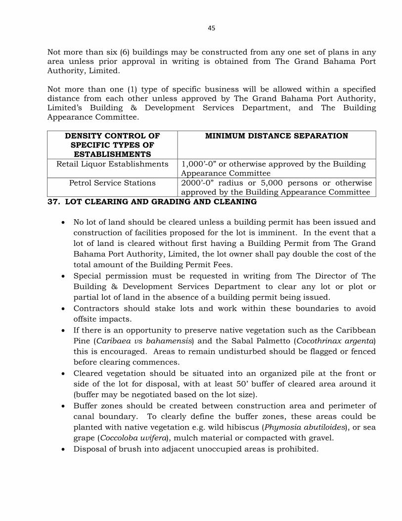
DENSITY CONTROL OF SPECIFIC TYPES OF ESTABLISHMENTS
MINIMUM DISTANCE SEPARATION
Retail Liquor Establishments 1,000’-0” or otherwise approved by the Building Appearance Committee
Petrol Service Stations 2000’-0” radius or 5,000 persons or otherwise approved by the Building Appearance Committee
37. LOT CLEARING AND GRADING AND CLEANING
• No lot of land should be cleared unless a building permit has been issued and construction of facilities proposed for the lot is imminent. In the event that a lot of land is cleared without first having a Building Permit from The Grand Bahama Port Authority, Limited, the lot owner shall pay double the cost of the total amount of the Building Permit Fees.
• Special permission must be requested in writing from The Director of The Building & Development Services Department to clear any lot or plot or partial lot of land in the absence of a building permit being issued.
• Contractors should stake lots and work within these boundaries to avoid offsite impacts.
• If there is an opportunity to preserve native vegetation such as the Caribbean Pine (Caribaea vs bahamensis) and the Sabal Palmetto (Cocothrinax argenta) this is encouraged. Areas to remain undisturbed should be flagged or fenced before clearing commences.
• Cleared vegetation should be situated into an organized pile at the front or side of the lot for disposal, with at least 50’ buffer of cleared area around it (buffer may be negotiated based on the lot size).
• Buffer zones should be created between construction area and perimeter of canal boundary. To clearly define the buffer zones, these areas could be planted with native vegetation e.g. wild hibiscus (Phymosia abutiloides), or sea grape (Coccoloba uvifera), mulch material or compacted with gravel.
• Disposal of brush into adjacent unoccupied areas is prohibited.
46
• Areas devoid of vegetation and exposed fine soils should be established with plantings or other landscape features as early as possible.
• Erosion prone areas should immediately be planted with grasses, shrubs or ground cover to minimize erosion.
• Properties should be graded in such a manner to avoid direct runoff into the surface waters, utilizing natural vegetative mechanisms for buffering and filtering purposes.
• Sweeping of small debris should not be directed into the street or any possible storm drains. Dust or other collected sweepings should be collected and disposed into an appropriate waste container.
• Construction materials should be stored in a dry safe place. • Debris including all waste resulting from construction should not be stored in
an open area or unsealed container – and must always be secured against storm and hurricane winds.
• A temporary construction dumpster should be located onsite for necessary disposal items.
• Rinsing of trucks, wheel barrows or other equipment should be performed only within enclosed graded berms fitted with a small sediment catch – to prevent entry of soils on to neighbouring properties. Materials should be periodically cleaned from the sediment catch.
• Paint, solvent and cleaning waster should not be dumped or poured down drains.
• Disposal of any construction debris into the adjacent canal, neighbouring lots or dump anywhere offsite is strictly prohibited – and liable to prosecution.
38. WATERWAY/CANAL PROTECTION
• No combustion engines should be used in the waterway. • No littering is permitted in the waterways. All debris generated during
construction or occupancy activities should be removed (i.e. floatables, litter etc.) at once. (All illegal dumping should be reported to the developer of the subdivision, and then to The Grand Bahama Port Authority, Limited.)
• All containers, materials, derelict vehicles or other possible refuse items should be properly secured and covered to avoid entry into the waterway or seepage into the groundwater resources.
• Special care should be given to the proper storage and disposal (removal) of pesticides, fertilizers, cleaners, paints, fuel, and other potentially hazardous materials to avoid seepage into the groundwater resources and entry into the waterway. Under no circumstances should these products be stored in an area susceptible to transport during storm events.
47
• If a spill occurs in the waterway, The Grand Bahama Port Authority, Limited as well as the subdivision’s developer should be contacted immediately, to determine the extent of remedial actions to be taken.
39. PEAROCK LANDSCAPE No more than 50% of the soft scape area can be pea rock or other inorganic material with the balance being organic vegetation (i.e. grass, flowers, shrubs, trees). In all cases, the ROW verge (beyond the property line) must be organic vegetation to match adjoining verges (i.e. grass). Note: The landscaping must be completed in its entirety before a certificate of occupancy will be issued.
40. DENSITY CONTROL OF SPECIFIC TYPES OF ESTABLISHMENTS
A. Frequency of Petrol Service Stations Service Stations should be spaced such that the minimum amount of persons potentially surrounding each station should not be less than 5,000 within a radius of 2000 feet without encroachment from another service station. B. Retail Liquor Establishments
Retail Liquor Establishments should be spaced a minimum of 1000’-0” apart, or otherwise approved by the Building Appearance Committee.
41. DOCKS, PIERS AND JETTYS No dock, pier, or jetty, including mooring piles, shall be constructed to extend more than 26 feet into any canal or waterway from MHW of the shoreline or from any seawall or bulkhead. No dock, pier or jetty shall be constructed on lands lying below mean high water without proper authorization from the Agent.
PLANNING PROCEDURES 42. PROCEDURES FOR SUBDIVISION OF LAND WITHIN THE PORT AREA
48
Preliminary Subdivision Plan The following documents are required to be submitted to the Building & Development Services Department of The Grand Bahama Port Authority, Limited for approval. Two sets of a preliminary plan showing the subdivision of the land with proper legal description along with the corresponding restrictive covenants and any other supporting documents. In the case of private subdivisions evidence of approval in principle by the subdivision’s developer is required. One set of the plans will be returned. Submission for Final Approval Once “approval in principle’ has been granted by The Grand Bahama Port Authority, Limited the land is to be surveyed in accordance with the conditions/restrictions contained in the documents and/or plan, then the final survey plan must be prepared & sealed by a licensed land surveyor & submitted to GBPA for approval. In the case of private subdivisions three (3) originals of the survey plan are to be stamped/signed by an officer of the Private Subdivision Developer (PGL, FCI, GB DEVCO, Bahamia, Tamarind, etc.) indicating approval of the plan. Accompanying the submission must be two (2) sets of construction plans for the required developments/infrastructure (as defined in the GBPA Bldg. & Sanitary Code 2010). These plans must bear the stamp/signature of the Private Subdivision Developer’s approval as well as the signature of the individual who holds responsibility for preparing the plans – i.e. the Licensed Engineer. Once all documents (both the survey drawings and construction documents) are approved, a performance bond to cover the cost of installation of all required infrastructural development must be lodged with The Grand Bahama Port Authority, Limited if infrastructural works are not implemented before hand. Once all obligations are met three sets of the final survey plans will be lodged with The Grand Bahama Port Authority, Limited. The Grand Bahama Port Authority, Limited will cause one (1) set of the final survey plans to be recorded by the government department of Lands and Surveys. A second set shall be returned to the owner or his representative. The third set will remain in the Planning and Projects Department of The Grand Bahama Port Authority, Limited. 43. PROCEDURES FOR RE-SUBDIVIDING A PARCEL WITHIN THE PORT AREA Preliminary Plan
49
Preliminary Plan showing subdivision of the land is prepared on Land Owner’s behalf (Note: all created parcels MUST have proper legal descriptions)
Preliminary Subdivision Plan along with proposed Restrictive Covenant and any other supporting documents “approved in principle” by Private Subdivision Developer PGL, FCI, GB Devco, Bahamia, Tamarind, etc.) Preliminary Subdivision Plan along with proposed Restrictive Covenant and any other supporting documents “approval in principle” and entered into the PIMS by GBPA Planning Dept. Required Improvements The land is to be surveyed in accordance with the conditions/restrictions contained in the document and/or plan which gives the “approval in principle” and the Survey Plan must be prepared and sealed by a Licensed Land Surveyor.
Three (3) originals of the Survey Plan are to be stamped/ signed by an officer of the Private Subdivision Developer (PGL, FCI, GB Devco, Bahamia, Tamarind, etc.) Survey Plan Recording Three (3) originals of the Survey Plan shall be recorded by GBPA Planning Dept. A GBPA Recording number is added and the original is scanned into the Document Archiving System.
Three (3) originals of GBPA Recorded Survey Plan recorded in Lands & Surveys along with a Unique Parcel Identifying Number (UPIN) for each parcel issued and PIMS amendments ratified by Bahamas Department of Lands & Surveys. One (1) original of Dept. of Lands & Surveys recorded Survey Plan scanned and filed by GBPA Planning. One (1) original of Dept. of Lands & Surveys recorded Survey Plan filed by Private Developer. 44. PROCEDURES TO RE-ZONE LAND WITHIN THE PORT AREA Letters are sent to the Lot Owners in the area in question advising of the need to re-zone. Their consent is requested in writing, to be received within a specified time period. The consent of 51% of the lot owners is required. 45. CRITERIA FOR GRANTING VARIANCES
50
A variance may be granted only in the event that all of the following criteria are
satisfied:
(1) Special conditions and circumstances exist which are peculiar to the land,
structure or building involved and which are not applicable to other lands,
structures or buildings in the same zoning district;
(2) The special conditions and circumstances do not result from the actions of the
provisions of the zoning regulation would deprive the applicant of rights commonly
enjoyed by other properties in the same zoning district under the applicant;
(3) The literal interpretation of the terms of the bylaw and would result in
unnecessary and undue hardship on the applicant;
(4) The variance granted is the minimum variance that will make possible the
reasonable use of the land, building or structure; and
(5) The granting of the variance will be in harmony with the general intent and
purpose of the regulation and such variance will not be injurious to the area
involved or otherwise detrimental to the public welfare.
46. INFRASTRUCTURE INSTALLATION BY PRIVATE DEVELOPERS WITHIN THE PORT AREA
Construction plans to be submitted by the developer to and approved by the Building and Development Services Department of The Grand Bahama Port Authority, Limited for installation of Power, Water and Road paving.
Inspections for Power & Water installations are carried out by the Power & Water Companies respectively.
Paving Inspection requirements:-
a. After clearing, inspection is needed during the ripping and grubbing process and
b. During the sub-base, base preparation and the
installation of the Asphalt Surface. Also
c. Must conform to the GBPA’s “Typical Sections” of road right-of-ways.
51
d. No certificates of occupancy would be granted to any individual
construction project unless infrastructure is in place. It is the responsibility of the developer to advise any and all owners and prospective owners of real estate within the development of this requirement.
47. PROCEDURES FOR DEMOLITION WITHIN THE PORT AREA
Any site which requires de-commissioning of facilities must have its owner or owner’s representative make application to the Building & Development Services Department (B & D S) of The Grand Bahama Port Authority, Limited in writing………..to obtain a valid demolition permit. The letter of application must give
1) The legal description of the site 2) Show a site layout of the facilities 3) Identify the nature of each facility 4) Indicate the procedure to be used for demolition 5) And supply other information as outlined in the Procedure for Demolition
written below.
A meeting with the Environment Department of The Grand Bahama Port Authority, Limited will be required to ascertain what Environmental information will be required – and this department must approve of the sequence and schedule of the de-commissioning/demolition.
Procedure for Demolition The following information is for the benefit of those desirous of carrying out
demolition works. It speaks to the regulatory requirements.
Demolitions may be categorized into the following classifications: Residential – i.e. houses, apartments, hotels, motels, guest houses, etc. Mercantile – i.e. office buildings, banks, stores, restaurants Institution – i.e. hospitals, schools, churches, club house, auditoriums, gymnasiums, etc. Industrial – chemical plants & storage, service stations, processing/manufacturing/fabrication/repairing of products Reclamation – removal of underground tanks and other mechanical structures
52
Decommissioning of Facilities – included but not limited to Industrial and Reclamation where chemical and mechanical processes are involved (see first paragraph)
The applicant must classify the type of demolition of which he/she is making application; and must indicate the procedure which will be used to demolish the building structures and or pipes and conduits………..such as explosives, mechanical equipment, manual labor, etc.
Demolition permits are secured using a demolition permit application form.
1. Who is authorized to secure Demolition Permits:
a. General Contractors b. Contractors licensed to engage in Demolition of Buildings & other
mechanical structures i.e. (process plants) c. Small demolitions may be supervised by and a permit may be
secured by a professional civil/structural engineer 2. Demolition Permit Requirements:
a. Notarized authorization from property owner to remove structure b. Secure proof of property ownership c. Environmental impact assessment If applicable d. Asbestos abatement disclosure if applicable e. Plot plan, drawn to scale, showing structure to be removed,
specifying the square footage of structure f. Value of demolition project g. A Trash Hauling Permit is required on all construction/demolition
projects from GBPA. h. Site Inspection approval by GBPA
3. Demolition procedures
a. Secure permit prior to commencement b. Have letters of terminations from G.B. Power Company pertinent
utilities c. Water service termination will have visual inspection by G.B. Utility d. Sewer service termination will be witnessed by the Building
Department e. Septic tank termination will be witnessed by the Building
Department f. Schedule an on-site inspection from Building Department on the day
of commencement of Demolition (48 hours notice required) g. Schedule of events for each day of demolition – to be submitted to the
Building Department. h. The Building Permit for demolition must be displayed on site at all
times.
53
i. Prior to works commencing the demolition contractor shall carry out an investigation of the building and site then advise B & D S of any matters relating to hazardous materials, interference of services or other matter which may influence the proposed demolition procedures.
j. Unless otherwise approved demolition works shall commence at the roof and be executed storey by storey working downwards.
k. The site shall be fully fenced off (unless otherwise approved) at the allotment boundaries to prevent unauthorized and unobstructed public access to the addressed allotment.
l. Notices displaying “Danger Demolition Works in Progress” or similar are to be fixed to the site fencing at clearly visible location(s).
m. Dust creating material, unless thoroughly dampened shall not be thrown or dropped from the building but shall be lowered by hoisting apparatus, or contained in a trash shute suspended not more than two (2) feet above trash container.
n. Buildings located close to allotment boundaries are to be reduced by hand. The demolisher must not carry out any works on, over or in the air space of an adjoining property without the prior approval from B & D S.
4. The Permit holder or the Owner is required to call for a Final Inspection:
a. Note permit stipulations b. Lot leveled, no ponding water c. All debris removed & properly disposed of d. If any, wells shall be properly terminated e. Backfilling of all underground tanks (septic or other) to approved
specifications f. Soil and ground water testing to confirm area is safe, where
applicable
5. Where the demolition involves removal of any structural members, a shoring plan must be submitted. The shoring plan must demonstrate how the remaining portion of the building will be supported. The plans shall be signed & sealed by a professional engineer. All Structural Demolition must be monitored by a Grand Bahama Port Authority, Limited licensed Professional Engineer of Record.
6. Exploratory Demolition Permits can only be issued to the contractor with the approval of the Building Official. It is issued for exploratory inspection to assist the Contractor, Architect and/or Engineer to determine the extent of the deterioration of the building.
7. The fee for demolition permits is estimated cost of service based on evaluation of project.
54
8. Police Department will search structure for unauthorized personnel prior to commencement.
9. It is mandatory to record the expected reasonable time of completion for the demolition exercise. In the event the completion of the exercise is not achieved in the time specified, The Grand Bahama Port Authority, Limited shall have the right to use the deposit being held to carryout the remaining works to remove the “eyesore” resulting from the incomplete works – or to complete the outstanding works at the owner’s expense.
55
48. PROCEDURES FOR PAVED ROADS WITHIN THE PORT AREA
Any subdivision which has an existing road (asphalt or drivable surface) and requires new paving the owner or owner’s representative of the development must make an application to the Building & Development Services Department (B & D S) of The Grand Bahama Port Authority, Limited in writing………..to obtain a valid road paving permit. The letter of application must give: Road Paving Permit Requirements:
1) The legal description of the site 2) Show a site layout 3) Plot plan, drawn to scale, showing roadway thickness detail
Road Paving procedures
• Schedule an on-site inspection from Building Department on the day of commencement of
• Land clearing and grubbing (removal of organic materials) • Lime rock base preparation (minimum 6”) • Application of tact coat • Installation of asphalt surface (SIII)
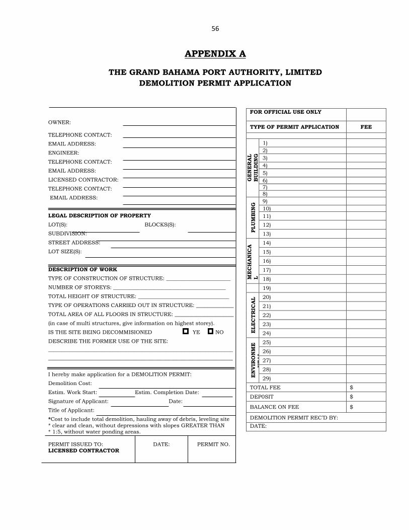
56
APPENDIX A
THE GRAND BAHAMA PORT AUTHORITY, LIMITED DEMOLITION PERMIT APPLICATION
OWNER: TELEPHONE CONTACT:
EMAIL ADDRESS:
ENGINEER:
TELEPHONE CONTACT:
EMAIL ADDRESS:
LICENSED CONTRACTOR:
TELEPHONE CONTACT:
EMAIL ADDRESS:
LEGAL DESCRIPTION OF PROPERTY LOT(S): BLOCKS(S):
SUBDIVISION:
STREET ADDRESS:
LOT SIZE(S):
DESCRIPTION OF WORK TYPE OF CONSTRUCTION OF STRUCTURE: ________________________
NUMBER OF STOREYS: __________________________________________
TOTAL HEIGHT OF STRUCTURE: __________________________________
TYPE OF OPERATIONS CARRIED OUT IN STRUCTURE: ______________
TOTAL AREA OF ALL FLOORS IN STRUCTURE: ______________________
(in case of multi structures, give information on highest storey).
IS THE SITE BEING DECOMMISIONED YE NO
DESCRIBE THE FORMER USE OF THE SITE: _____________________________________________________________________ _____________________________________________________________________ I hereby make application for a DEMOLITION PERMIT:
Demolition Cost:
Estim. Work Start: Estim. Completion Date:
Signature of Applicant: Date:
Title of Applicant:
*Cost to include total demolition, hauling away of debris, leveling site * clear and clean, without depressions with slopes GREATER THAN * 1:5, without water ponding areas. PERMIT ISSUED TO: DATE: PERMIT NO. LICENSED CONTRACTOR
FOR OFFICIAL USE ONLY
TYPE OF PERMIT APPLICATION FEE
GE
NE
RA
L B
UIL
DIN
G
1) 2) 3) 4) 5) 6) 7) 8)
PLU
MB
ING
9) 10) 11)
12)
13)
ME
CH
AN
ICA
L
14)
15)
16)
17)
18)
19)
ELE
CT
RIC
AL 20)
21)
22)
23)
24)
EN
VIR
ON
ME
NT
AL
25)
26)
27)
28)
29)
TOTAL FEE $
DEP0SIT $
BALANCE ON FEE $
DEMOLITION PERMIT REC’D BY: DATE:
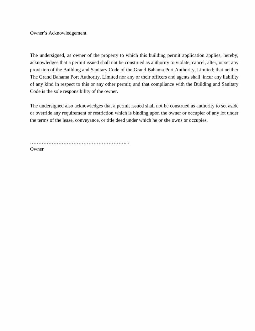
Owner’s Acknowledgement
The undersigned, as owner of the property to which this building permit application applies, hereby, acknowledges that a permit issued shall not be construed as authority to violate, cancel, alter, or set any provision of the Building and Sanitary Code of the Grand Bahama Port Authority, Limited; that neither The Grand Bahama Port Authority, Limited nor any or their officers and agents shall incur any liability of any kind in respect to this or any other permit; and that compliance with the Building and Sanitary Code is the sole responsibility of the owner. The undersigned also acknowledges that a permit issued shall not be construed as authority to set aside or override any requirement or restriction which is binding upon the owner or occupier of any lot under the terms of the lease, conveyance, or title deed under which he or she owns or occupies. …………………………………………………... Owner
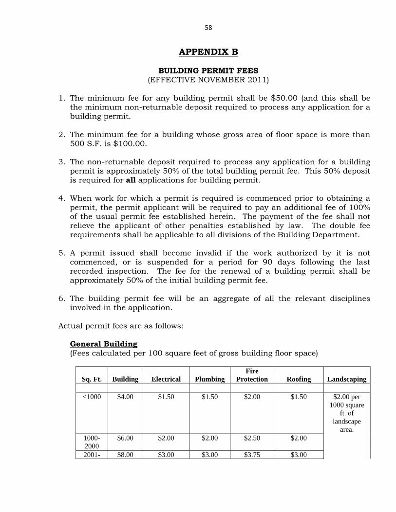
58
APPENDIX B
BUILDING PERMIT FEES (EFFECTIVE NOVEMBER 2011)
1. The minimum fee for any building permit shall be $50.00 (and this shall be
the minimum non-returnable deposit required to process any application for a building permit.
2. The minimum fee for a building whose gross area of floor space is more than
500 S.F. is $100.00.
3. The non-returnable deposit required to process any application for a building permit is approximately 50% of the total building permit fee. This 50% deposit is required for all applications for building permit.
4. When work for which a permit is required is commenced prior to obtaining a
permit, the permit applicant will be required to pay an additional fee of 100% of the usual permit fee established herein. The payment of the fee shall not relieve the applicant of other penalties established by law. The double fee requirements shall be applicable to all divisions of the Building Department.
5. A permit issued shall become invalid if the work authorized by it is not
commenced, or is suspended for a period for 90 days following the last recorded inspection. The fee for the renewal of a building permit shall be approximately 50% of the initial building permit fee.
6. The building permit fee will be an aggregate of all the relevant disciplines
involved in the application.
Actual permit fees are as follows: General Building (Fees calculated per 100 square feet of gross building floor space)
Sq. Ft.
Building
Electrical
Plumbing
Fire Protection
Roofing
Landscaping
<1000 $4.00 $1.50 $1.50 $2.00 $1.50 $2.00 per
1000 square ft. of
landscape area.
1000-2000
$6.00 $2.00 $2.00 $2.50 $2.00
2001- $8.00 $3.00 $3.00 $3.75 $3.00
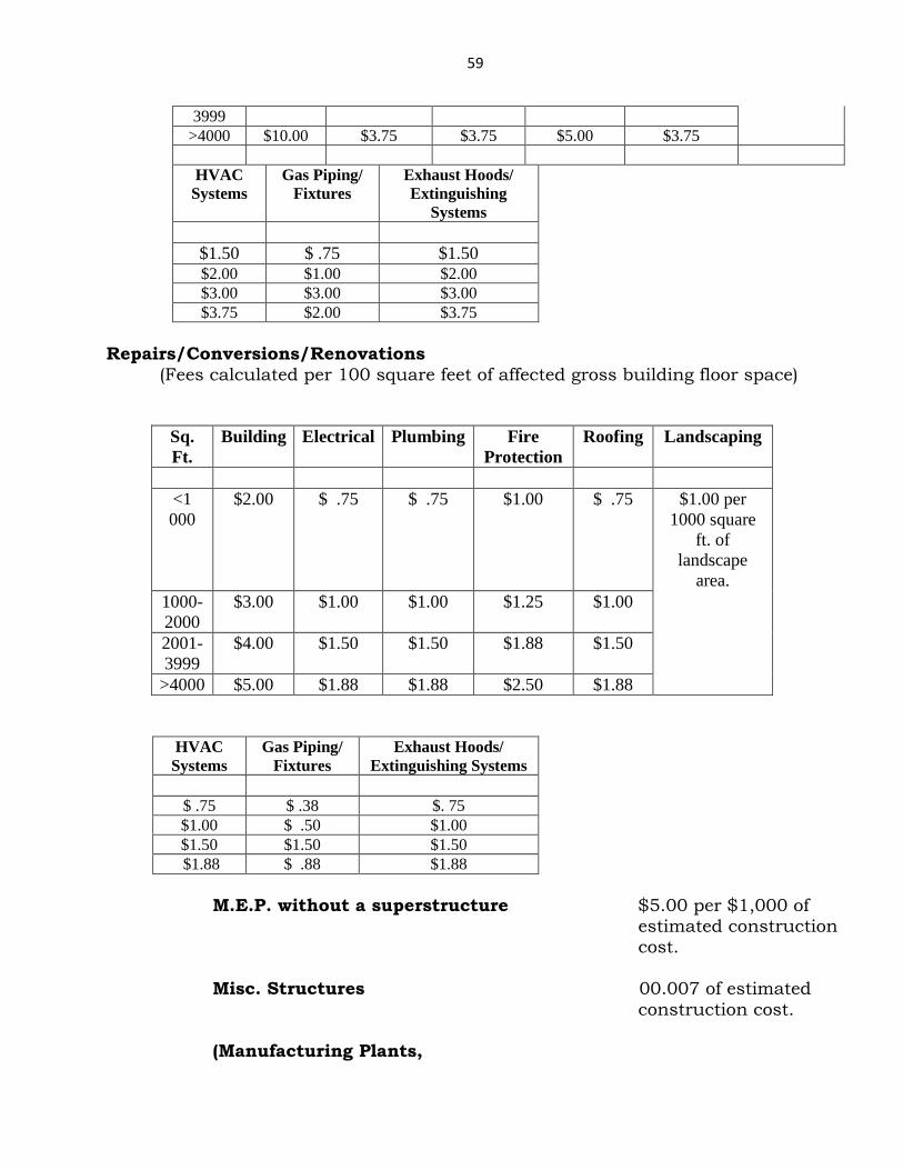
59
3999 >4000 $10.00 $3.75 $3.75 $5.00 $3.75
HVAC
Systems Gas Piping/
Fixtures Exhaust Hoods/ Extinguishing
Systems
$1.50 $ .75 $1.50 $2.00 $1.00 $2.00 $3.00 $3.00 $3.00 $3.75 $2.00 $3.75
Repairs/Conversions/Renovations (Fees calculated per 100 square feet of affected gross building floor space)
Sq. Ft.
Building Electrical Plumbing Fire Protection
Roofing Landscaping
<1 000
$2.00 $ .75 $ .75 $1.00 $ .75 $1.00 per 1000 square
ft. of landscape
area. 1000-2000
$3.00 $1.00 $1.00 $1.25 $1.00
2001-3999
$4.00 $1.50 $1.50 $1.88 $1.50
>4000 $5.00 $1.88 $1.88 $2.50 $1.88
HVAC
Systems Gas Piping/
Fixtures Exhaust Hoods/
Extinguishing Systems
$ .75 $ .38 $. 75 $1.00 $ .50 $1.00 $1.50 $1.50 $1.50 $1.88 $ .88 $1.88
M.E.P. without a superstructure $5.00 per $1,000 of estimated construction cost. Misc. Structures 00.007 of estimated construction cost. (Manufacturing Plants,
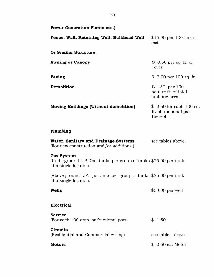
60
Power Generation Plants etc.) Fence, Wall, Retaining Wall, Bulkhead Wall $15.00 per 100 linear feet Or Similar Structure Awning or Canopy $ 0.50 per sq. ft. of cover Paving $ 2.00 per 100 sq. ft. Demolition $ .50 per 100 square ft. of total building area. Moving Buildings (Without demolition) $ 2.50 for each 100 sq. ft. of fractional part thereof
Plumbing Water, Sanitary and Drainage Systems see tables above. (For new construction and/or additions.) Gas System (Underground L.P. Gas tanks per group of tanks $25.00 per tank at a single location.) (Above ground L.P. gas tanks per group of tanks $25.00 per tank at a single location.) Wells $50.00 per well Electrical Service (For each 100 amp. or fractional part) $ 1.50 Circuits (Residential and Commercial wiring) see tables above Motors $ 2.50 ea. Motor
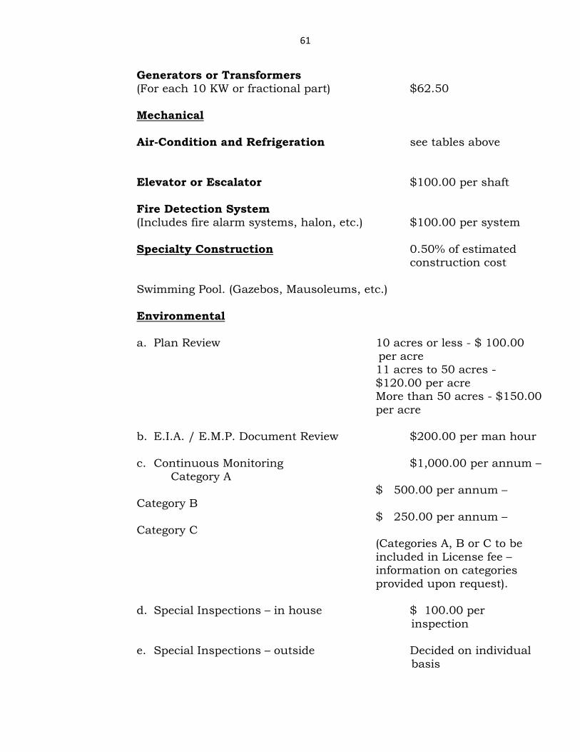
61
Generators or Transformers (For each 10 KW or fractional part) $62.50 Mechanical Air-Condition and Refrigeration see tables above
Elevator or Escalator $100.00 per shaft Fire Detection System (Includes fire alarm systems, halon, etc.) $100.00 per system Specialty Construction 0.50% of estimated construction cost Swimming Pool. (Gazebos, Mausoleums, etc.) Environmental a. Plan Review 10 acres or less - $ 100.00
per acre 11 acres to 50 acres - $120.00 per acre More than 50 acres - $150.00 per acre
b. E.I.A. / E.M.P. Document Review $200.00 per man hour
c. Continuous Monitoring $1,000.00 per annum –
Category A $ 500.00 per annum – Category B $ 250.00 per annum – Category C
(Categories A, B or C to be included in License fee – information on categories provided upon request).
d. Special Inspections – in house $ 100.00 per
inspection
e. Special Inspections – outside Decided on individual basis

62
Note: 1. Example of Categories:
a. Category A – 40 hrs. per annum @ $25.00 per hr. b. Category B – 20 hrs. per annum @ $25.00 per hr. c. Category C – 10 hrs. per annum @ $25.00 per hr. Categories are graded by the Environmental Department based on visit/hrs. required per annum.
2. Special Inspections:
a. Inspections carried out for additions to original documents. b. Inspections otherwise requested by Owner or Contractor. c. Special Inspections as requested by B & D S to be carried out by
Outside Experts.
Road Work New - $ .10 per square ft. Resurfacing - $ .03 per square ft.
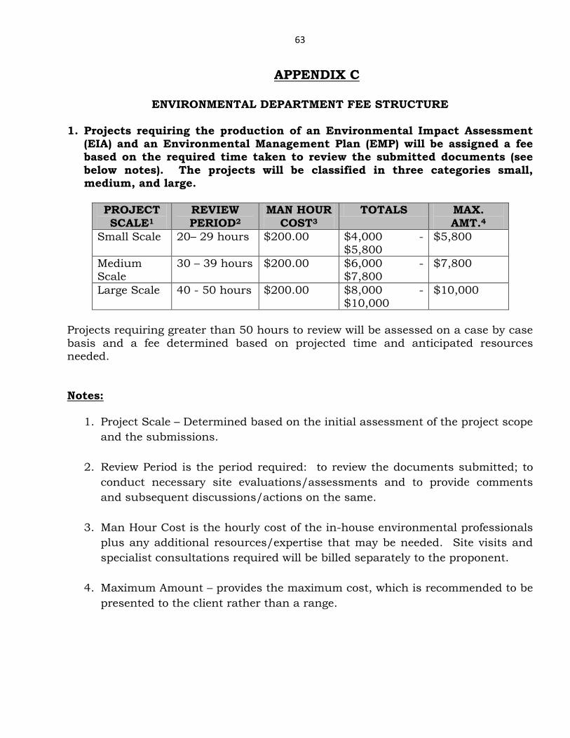
63
APPENDIX C
ENVIRONMENTAL DEPARTMENT FEE STRUCTURE 1. Projects requiring the production of an Environmental Impact Assessment
(EIA) and an Environmental Management Plan (EMP) will be assigned a fee based on the required time taken to review the submitted documents (see below notes). The projects will be classified in three categories small, medium, and large.
PROJECT SCALE1
REVIEW PERIOD2
MAN HOUR COST3
TOTALS MAX. AMT.4
Small Scale 20– 29 hours $200.00 $4,000 -$5,800
$5,800
Medium Scale
30 – 39 hours $200.00 $6,000 -$7,800
$7,800
Large Scale 40 - 50 hours $200.00 $8,000 - $10,000
$10,000
Projects requiring greater than 50 hours to review will be assessed on a case by case basis and a fee determined based on projected time and anticipated resources needed. Notes:
1. Project Scale – Determined based on the initial assessment of the project scope and the submissions.
2. Review Period is the period required: to review the documents submitted; to conduct necessary site evaluations/assessments and to provide comments and subsequent discussions/actions on the same.
3. Man Hour Cost is the hourly cost of the in-house environmental professionals plus any additional resources/expertise that may be needed. Site visits and specialist consultations required will be billed separately to the proponent.
4. Maximum Amount – provides the maximum cost, which is recommended to be presented to the client rather than a range.
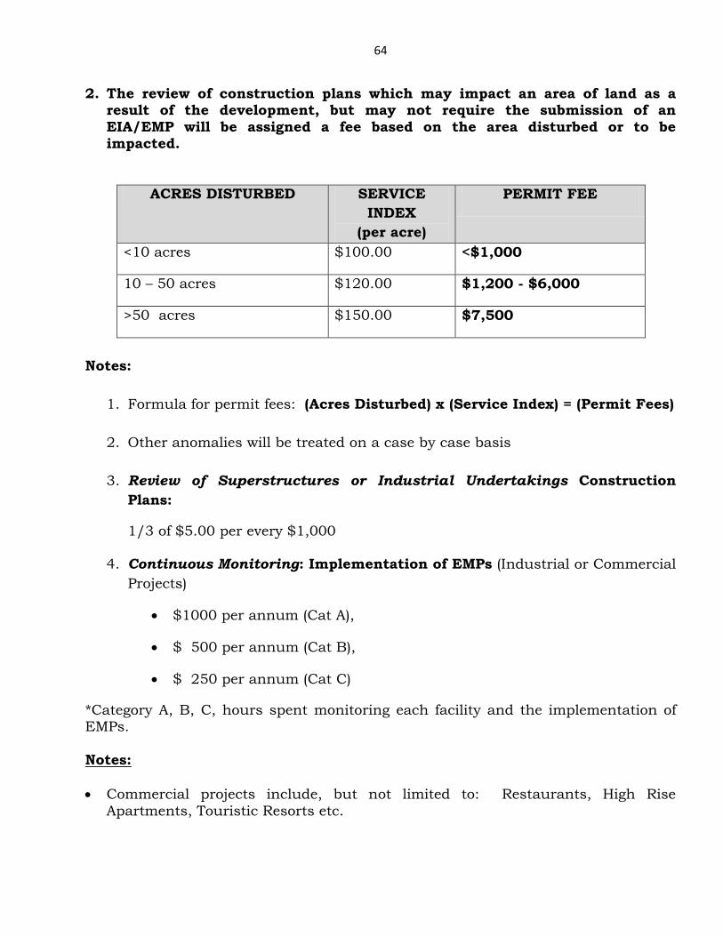
64
2. The review of construction plans which may impact an area of land as a result of the development, but may not require the submission of an EIA/EMP will be assigned a fee based on the area disturbed or to be impacted.
ACRES DISTURBED SERVICE INDEX
(per acre)
PERMIT FEE
<10 acres $100.00 <$1,000
10 – 50 acres $120.00 $1,200 - $6,000
>50 acres $150.00 $7,500
Notes:
1. Formula for permit fees: (Acres Disturbed) x (Service Index) = (Permit Fees)
2. Other anomalies will be treated on a case by case basis
3. Review of Superstructures or Industrial Undertakings Construction Plans:
1/3 of $5.00 per every $1,000
4. Continuous Monitoring: Implementation of EMPs (Industrial or Commercial Projects)
• $1000 per annum (Cat A),
• $ 500 per annum (Cat B),
• $ 250 per annum (Cat C)
*Category A, B, C, hours spent monitoring each facility and the implementation of EMPs. Notes: • Commercial projects include, but not limited to: Restaurants, High Rise
Apartments, Touristic Resorts etc.
65
• Industrial projects include, but not limited to such activities: Refurbishing, Mining, Transshipment, Manufacturing and Assembling Operations.
Example of industrial categories and associated monitoring fees:
Category A (minimum of forty hours per annum x $25.00): Category B (minimum of twenty hours per annum x $25.00): Category C (minimum of ten hours per annum x $25.00):
N.B. Other projects which are comprised of an aspect that may warrant some type of Environmental Review would be considered in this process. A determination of whether a fee should be added to the permit fee would be discretionary, based on the nature of the project or the environment in which the project is being proposed.
66
APPENDIX D
Guide for Business Licenses and Building Permit Applications Requiring Environmental Review
• Projects being proposed in areas of sensitive habitats – wetlands, mangroves, dunes, sea grass, coral reefs etc.
• Projects which will substantially affect rare or endangered species of animals or plants or the habitats of these species.
• Industrial related projects, which have potential issues of noise pollution, liquid and solid waste generation and disposal, air pollution etc.
• Projects abutting waterways that may degrade surface water quality, including
fresh and saline waters, or involve the release of significant amounts of pollutants to surface water.
• Coastal developments requiring the implementation of engineering
devices/coastal structures – groins, jetties, breakwaters etc.
• Construction of marinas and harbours – dredging etc.
• Upland developments (terrestrial areas) altering the hydrogeological and physical landscape, by such means as excavation.
• Non-hazardous and Hazardous projects which may require deep well injection
disposal.
• Large scale commercial/resort type projects requiring the conversion of large spans of natural resources (acreage).
• Developments in the vicinity of protected areas, such as the Rand Nature
Centre and Lucayan National Park.
• Projects requiring construction and demolition (C&D) activities
• Projects which may disrupt or adversely affect a prehistoric or historic archaeological site or
• Property of historic or cultural significance to a community or ethnic or social
group or a paleontological site except as part of a scientific study.
• Projects which will induce substantial growth or concentration of population. • Projects which will have aesthetic, health and sanitation issues.
67
• Projects which will irrevocably commit, degrade, or destroy any unique or
limited environmental resource, or a significant portion of any environmental resource.
• Any projects or circumstances that may be new in nature to the Port Area
and/or may be deemed by the GBPA as requiring the necessary environmental review because of its potential implications and uncertainties.
Note: The environmental review process entails the: evaluation of details associated with the project, inspection of the proposed location, development (if necessary) of conditions to be attached to any permits granted and determination as to whether or not an environmental assessment and/or management plan is required of the proponent.

68
APPENDIX E
69
APPENDIX F
Architect/Engineer of Record
The Building & Development Services Department (B & D S) of The Grand Bahama Port Authority (GBPA) issues building permits in accordance with all GBPA requirements, which include compliance with the Professional Engineers Act, 2004 and the Professional Architects Act, 1994. For projects which contain work of structural, electrical, mechanical, civil, architectural, environmental or other engineering or specialized design an engineer of record is required for each discipline. In the case of architectural involvement, an architect of record (AOR) is required. In the process of executing projects requiring permits, the GBPA requires the identification of an Engineer of Record (EOR), usually the firm/individual responsible for the submission of the design documents, and has developed specific expectations of this position during the design and construction of the project. The guidelines herein have been developed to further explain the requirements of an EOR (or Architect of Record, when applicable) associated with development projects that fall under the jurisdiction of the GBPA. GBPA requires that design drawings submitted to the Building & Development Services Department be signed and sealed by a licensed Professional Engineer or licensed Professional Architect (where applicable) who holds a GBPA license, and is registered with the Professional Engineers Board (or Professional Architects Board). The licensed Professional Engineer or Architect is responsible and liable for the adequacy and completeness of the design drawings submitted. Following design review, Building & Development Services shall issue comments, request further documentation, or take other actions necessary to either accept the design drawings and issue a permit, conditionally accept the design drawings and issue a permit with conditions, or to deny the issuance of a permit. In the event multiple engineering disciplines are represented in the design drawing set, a Professional Engineer holding a license in said discipline must sign and seal the associated drawings, GBPA may or may not require that a single point of contact be established, at the time of submission, denoting the Port licensed Engineer or Engineering Firm responsible for the permit application. This EOR or AOR holds responsibility for coordinating with GBPA relative to the permitting process. In such cases, GBPA requires that Owners/Applicants denote the Port-licensed Engineer or Engineering Firm or Licensed Architect or Architectural Firm who shall serve as EOR/AOR for each project and that will be the single point of contact for design drawing coordination with GBPA. Following issuance of a permit, GBPA requires that the EOR monitors construction to ensure conformance to the approved design. The EOR remains responsible for ensuring that construction is performed in accordance with the
70
EOR’s design. The EOR shall inspect the Works prior to inspection by the Port to ensure design conformance. Following completion of construction, the EOR shall submit signed and sealed Record Drawings denoting the project as it was constructed. The AOR may be required to have similar involvement for certain projects. For complex or large projects, GBPA may request that the Owner, through its EOR, provide a part-or full-time Resident Inspector (RI). The purpose of the RI is to provide the appropriate monitoring and inspection of the Works to ensure compliance with the approved design, for projects of significant scope, complexity, or that are fast-tracked. This should include periodic reports documenting the Works, including pictures and notations regarding any nonconformance issues encountered. The inspection reports and other construction inspection activities are to be reviewed and used by the Professional Engineer(s) who signed and sealed the drawings, as coordinated by the EOR, to support development of Record Drawings. The AOR may be required to have similar involvement. Meetings – The GBPA will expect all EORs to be represented at any and all general meetings between the projects managers/contractors and the B & D S Department of GBPA. The GBPA may request this involvement from the AOR on particular projects.