Embed Size (px)
Citation preview
ISSN 1064�2293, Eurasian Soil Science, 2015, Vol. 48, No. 12, pp. 1279–1291. © Pleiades Publishing, Ltd., 2015.Original Russian Text © Yu.G. Chendev, E.R. Lupo, M.G. Lebedeva, D.A. Borbukova, 2015, published in Pochvovedenie, 2015, No. 12, pp. 1411–1423.
1279
INTRODUCTION
Russian paleopedology has accumulated consider�able factual materials on the Holocene evolution of soilsin east European regions with numerous archaeologicalmonuments (kurgans, ramparts, ancient settlements,etc.) that serve as the main objects for reconstruction ofthe Holocene history of soils and the environment.
In recent years, the major attention of researchershas been focused on the chronological refinement ofpaleosol reconstructions in a number of east Europeanregions, soil evolution on newly investigated territo�ries, and on the search for new methods of the study ofevolution of soils and the environment [2, 7, 17–21,23, 38, 43, 48]. The method of soil chronosequencesdeveloped by Zolotun in his seminal work [24] is thekey method to study the Holocene evolution of soils.Afterwards, analogous studies have been performed bymany pedologists working in different regions. Themajor stages of the development of archaeological soilscience in Russia have been discussed in detail in sev�eral reviews [11, 21, 26–29].
In 2007, the first results of the analysis of data onsoil chronosequences for the Subboreal period of theHolocene in the southern part of east Europe and inthe southern Transural region were published [46]. Inthis study, the climatic evolution of several profile�forming soil properties was discussed, and an attemptfor mapping of the spatiotemporal patterns of the soilproperties in the considered region was made. Sincethat time, new data on the soil properties have been
obtained. They make it possible to construct longersoil chronosequences via adding paleosol data on keysites studied near the earlier investigated short soilchronosequences [14, 18, 19, 23, 37, 38, 44, 45, 48].The problems related to the spatial and temporalchanges of soils are of great interest not only for ped�ologists but also for climatologists (including coau�thors of this paper). The views of climatologists can beimportant for interpreting pedochronological infor�mation in paleoclimatic reconstructions.
OBJECTS AND METHODS
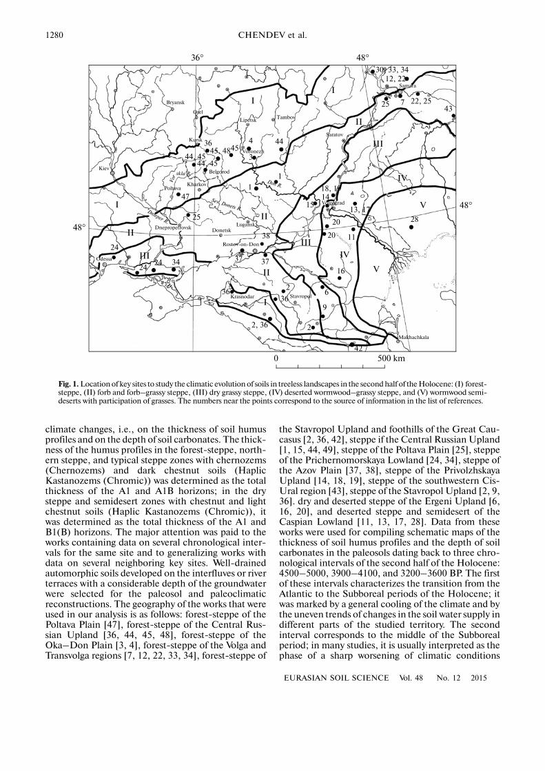
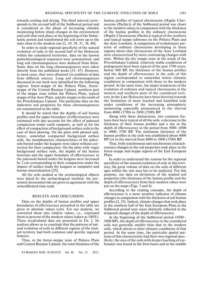
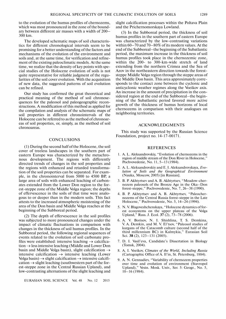
The studied territory includes the forest�steppe,steppe, and semidesert zones of the southern part ofthe East European Plain within 45°–54° N and 30°–53° E (Fig. 1). In terms of geomorphology, it includesfoothills of the Great Caucasus; the Central Russian,Kalach, Privolzhskaya, and Stavropol uplands; thePoltava, Oka–Don, and Azov plains; and the Pricher�nomorskaya (Black Sea) and Caspian lowlands. Tree�less landscapes predominate in these regions. Auto�morphic pedogenesis took place under the impact ofherbaceous or shrub vegetation during the entireHolocene. Many soil scientists studied the evolutionof soils in this region using the method of soil chro�nosequences on dated archaeological objects. For ouranalysis, we selected the works that contained data ondefinitely determined chronosequences and reliableindicative characteristics of soil evolution sensitive to
GENESIS AND GEOGRAPHY OF SOILS
Regional Specificity of the Climatic Evolution of Soils in the Southern Part of Eastern Europe in the Second Half of the Holocene
Yu. G. Chendeva, E. R. Lupob, M. G. Lebedevaa, and D. A. Borbukovaa
aBelgorod National Research University, ul. Pobedy 85, Belgorod, 308015 RussiabUniversity of Missouri, 302 Anheuser�Busch Natural Resources Building, Columbia, MO 65211�7250, USA
e�mail: [email protected] Received December 8, 2014
Abstract—The analysis of characteristic features of chernozems and chestnut soils of different ages that havebeen formed in the south of the East European Plain in the past 5000 years attests to the spatial and temporalheterogeneity of the rate and direction of pedogenetic processes, i.e., to the metachronous development ofthe soil cover. A linear zone of the retarded (before 3600–3200 years ago) and, then, enhanced developmentof the humus profiles of chernozems was found along the Voeikov climatic axis corresponding to the contactzone between cyclonic and anticyclonic weather conditions. It was concluded about the significant rise in thedegree of atmospheric moistening of the territory took place at the end of the Subboreal–the beginning of theSubatlantic periods of the Holocene. This factor favored the more active growth of the humus profiles of cher�nozems in this zone in comparison with chernozems on adjacent territories.
Keywords: chernozem, paleosols, Chernozems, Haplic Kastanozems (Chromic)
DOI: 10.1134/S1064229315120042
1280
EURASIAN SOIL SCIENCE Vol. 48 No. 12 2015
CHENDEV et al.
climate changes, i.e., on the thickness of soil humusprofiles and on the depth of soil carbonates. The thick�ness of the humus profiles in the forest�steppe, north�ern steppe, and typical steppe zones with chernozems(Chernozems) and dark chestnut soils (HaplicKastanozems (Chromic)) was determined as the totalthickness of the A1 and A1B horizons; in the drysteppe and semidesert zones with chestnut and lightchestnut soils (Haplic Kastanozems (Chromic)), itwas determined as the total thickness of the A1 andB1(B) horizons. The major attention was paid to theworks containing data on several chronological inter�vals for the same site and to generalizing works withdata on several neighboring key sites. Well�drainedautomorphic soils developed on the interfluves or riverterraces with a considerable depth of the groundwaterwere selected for the paleosol and paleoclimaticreconstructions. The geography of the works that wereused in our analysis is as follows: forest�steppe of thePoltava Plain [47], forest�steppe of the Central Rus�sian Upland [36, 44, 45, 48], forest�steppe of theOka–Don Plain [3, 4], forest�steppe of the Volga andTransvolga regions [7, 12, 22, 33, 34], forest�steppe of
the Stavropol Upland and foothills of the Great Cau�casus [2, 36, 42], steppe if the Central Russian Upland[1, 15, 44, 49], steppe of the Poltava Plain [25], steppeof the Prichernomorskaya Lowland [24, 34], steppe ofthe Azov Plain [37, 38], steppe of the PrivolzhskayaUpland [14, 18, 19], steppe of the southwestern Cis�Ural region [43], steppe of the Stavropol Upland [2, 9,36]. dry and deserted steppe of the Ergeni Upland [6,16, 20], and deserted steppe and semidesert of theCaspian Lowland [11, 13, 17, 28]. Data from theseworks were used for compiling schematic maps of thethickness of soil humus profiles and the depth of soilcarbonates in the paleosols dating back to three chro�nological intervals of the second half of the Holocene:4500–5000, 3900–4100, and 3200–3600 BP. The firstof these intervals characterizes the transition from theAtlantic to the Subboreal periods of the Holocene; itwas marked by a general cooling of the climate and bythe uneven trends of changes in the soil water supply indifferent parts of the studied territory. The secondinterval corresponds to the middle of the Subborealperiod; in many studies, it is usually interpreted as thephase of a sharp worsening of climatic conditions
48°
48°
48°36°
II
II
II
III
IV
V
IV
V
III
III
II
II
I
I
36
44, 4544, 45
45, 4845
25
47
24
2424
34 37 37
38
3636
2, 36
2
2
6
9
42
16
20
20
11
13, 17
18, 1914
15
1
1
3
4 44
25
30, 33, 3412, 22
22, 2543
7
28
TambovLipetsk
Orel
Bryansk
Kursk
PoltavaKharkov
BelgorodKiev
Dnepropetrovsk DonetskLugansk
Rostov�on�Don
Odessa
Krasnodar Stavropol
Makhachkala
Volgograd
Saratov
Samara
Voronezh
Don R.
Vor
skla R.
Dnieper R.
Sev. Donets R.
0 500 km
Fig. 1. Location of key sites to study the climatic evolution of soils in treeless landscapes in the second half of the Holocene: (I) forest�steppe, (II) forb and forb–grassy steppe, (III) dry grassy steppe, (IV) deserted wormwood–grassy steppe, and (V) wormwood semi�deserts with participation of grasses. The numbers near the points correspond to the source of information in the list of references.
EURASIAN SOIL SCIENCE Vol. 48 No. 12 2015
REGIONAL SPECIFICITY OF THE CLIMATIC EVOLUTION OF SOILS 1281
towards cooling and drying. The third interval corre�sponds to the second half of the Subboreal period andis considered as the phase of increasing climaticmoistening before sharp changes in the environmentand soils that took place at the beginning of the Subat�lantic period and transformed the soil cover up to thestate close to the modern one [2, 10, 30, 31, 36, 40].
In order to study regional specificity of the naturalevolution of soils in the second half of the Holocenewithin the considered territories, data on the knownpedochronological sequences were systematized, andlong soil chronosequences were deduced from them.Some data on the long chronosequences were takendirectly from the published works [25, 47]. However,in most cases, they were obtained via synthesis of datafrom different sources. Long soil chronosequencesdiscussed in our work were identified for the followingregions: forest�steppe of the Poltava Plain, forest�steppe of the Central Russian Upland, northern partof the steppe zone within the Poltava Plain, typicalsteppe of the Azov Plain, and dry steppe in the south ofthe Privolzhskaya Upland. The particular data on theindicative soil properties for these chronosequencesare summarized in the table.
It should be noted that the depths of soil humusprofiles and the upper boundary of effervescence wereestimated with due account for the effect of paleosolcompaction under earth ramparts, as well as for theeffect of compaction of background surface soils in thecase of their plowing. On the plots with plowed and,hence, somewhat compacted background surfacesoils, the morphometric characteristics of the paleo�sols buried under the kurgans were taken without cor�rection for their compaction. On the plots with virginbackground surface soils, the depths of the humushorizons and the upper boundary of effervescence inthe paleosols buried under the kurgans were increasedby 2 cm corresponding to their compaction under theimpact of surface loads (by kurgans or ramparts) andhumus mineralization [25].
All the soils studied at the archaeological objectswere dated by the archaeological method; the pre�sented chronointervals are given in agreement with thenoncalibrated time scale.
RESULTS AND DISCUSSION
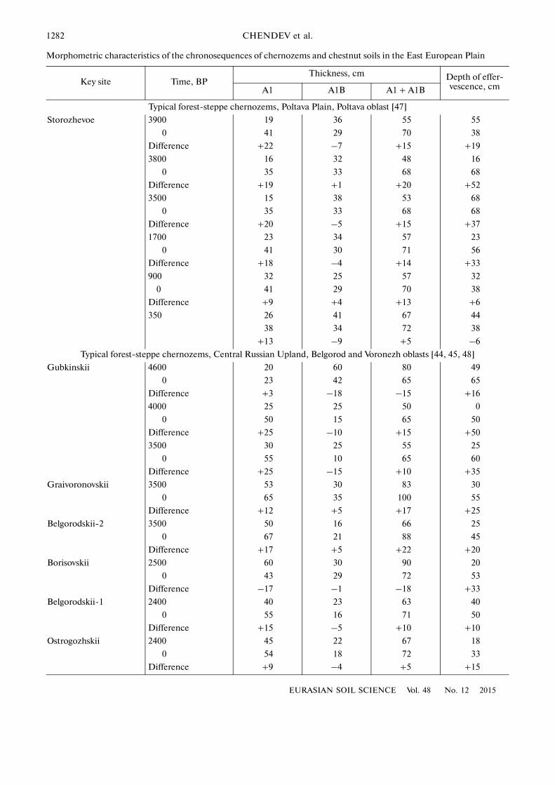
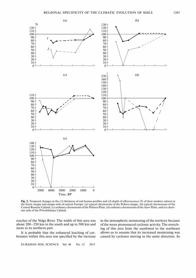
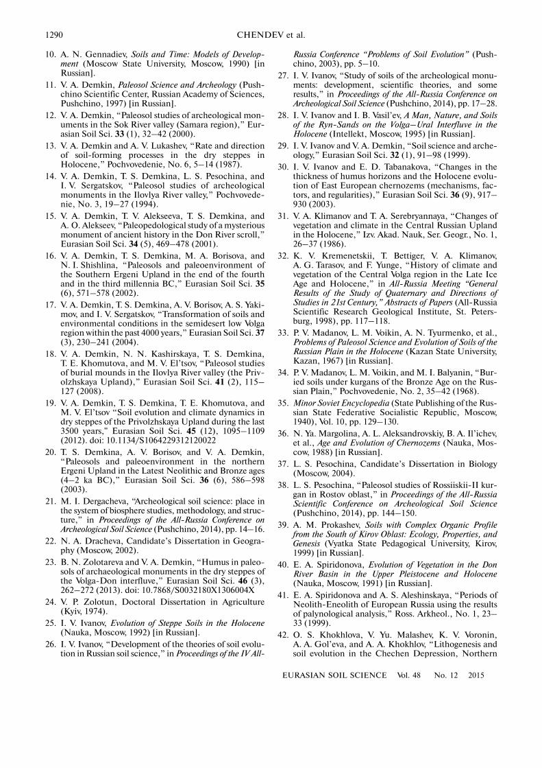
Data on the depths of humus profiles and upperboundaries of effervescence presented in the table aregiven in absolute values (cm). For our analysis, weconverted them into relative values, i.e., expressedthem in percent of the modern values (taken as 100%).These recalculated data are presented in Fir. 2. Itsanalysis allows us to conclude that the patterns of nat�ural evolution of soils in different regions of the stud�ied territory had both common and specific regionalfeatures.
Thus, in the forest�steppe zone of Poltava Plainand Central Russian Upland, the total thickness of the
humus profiles of typical chernozems (Haplic Cher�nozems (Pachic)) of the Subboreal period was closerto the modern values in comparison with the thicknessof the humus profiles in the ordinary chernozems(Haplic Chernozems (Pachic)) typical of the northernand typical steppe subzones on the Poltava Plain andthe Azov Lowland. A comparison of evolutionary pat�terns of ordinary chernozems developing in theseregions shows that chernozems of the Azov Lowlandwere characterized by more contrasting changes withtime. Within the dry steppe zone in the south of thePrivolzhskaya Upland, relatively stable conditions ofpedogenesis have been typical of the past 3700 years;before 900 BP, the thickness of the humus profilesand the depth of effervescence in the soils of thisregion corresponded to somewhat wetter climaticconditions in comparison with those in the modernperiod. At the same time, the major tendencies of theevolution of ordinary and typical chernozems in thewestern and northern parts of the considered terri�tory in the Late Holocene have been directed towardsthe formation of more leached and humified soilsunder conditions of the increasing atmosphericmoistening especially pronounced in the intervalfrom 4000 (3700) to 2800 (2500) BP.
Along with these distinctions, two common fea�tures have been typical of all the soils: a decrease in thethickness of their humus profiles and a rise in thedepth of effervescence in the period from 5000–4500to 4000–3700 BP. The minimum thickness of thehumus profiles in the soils was established about 4000BP (or in the interval from 4000 to 3800 (3700) BP.
Thus, both synchronous and synchronous (metach�ronous) changes in the soil properties took place in theforest�steppe and steppe regions of the East EuropeanPlain.
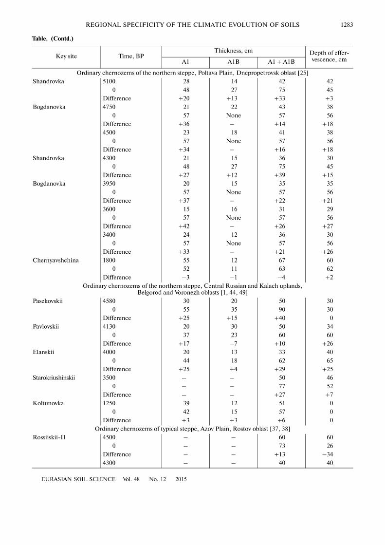
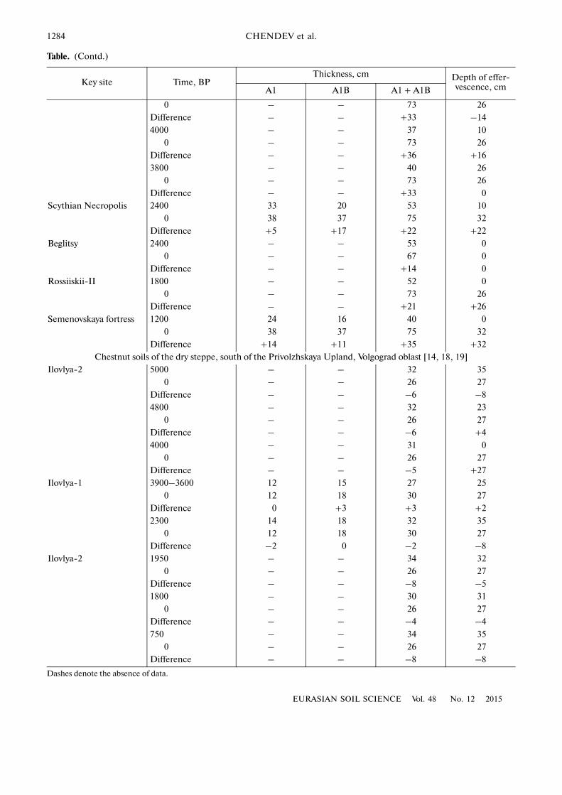
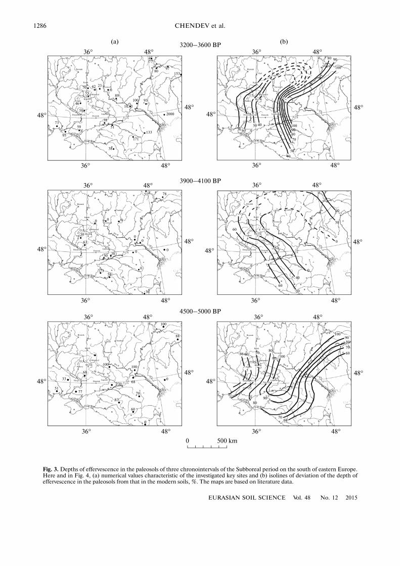
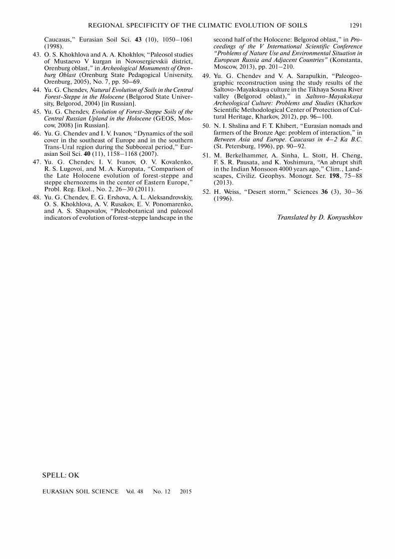
In order to understand the reasons for the regionalspecificity of the natural evolution of soils in this terri�tory, the great volume of data on the soils of differentages within the vast area has to be analyzed. For thispurpose, our data on deviations of the studied soilproperties (the thickness of the humus profile and thedepth of effervescence) from their modern values wereput on the maps (Figs. 3 and 4).
According to the existing concepts, the depth ofeffervescence is a more sensitive indicator of climatechanges in comparison with the thickness of soil humusprofiles [2, 25]. Indeed, climate changes that took placein the southern half of the East European Plain in theSubboreal period were more distinctly reflected in thetemporal changes of the depth of effervescence.
At the beginning of the Subboreal period (4500–5000 BP), the depth of effervescence in the consideredsoils was generally smaller than that in the modernsoils, which attests to drier climatic conditions of thatperiod. At the same time, the particular spatial pat�terns of this characteristic had their own regional spec�ificity; the area of the soils with deeper leaching of car�bonates was found in the Don basin and in the middle
1282
EURASIAN SOIL SCIENCE Vol. 48 No. 12 2015
CHENDEV et al.
Morphometric characteristics of the chronosequences of chernozems and chestnut soils in the East European Plain
Key site Time, BPThickness, cm Depth of effer�
vescence, cmA1 A1B A1 + A1B
Typical forest�steppe chernozems, Poltava Plain, Poltava oblast [47]
Storozhevoe 3900 19 36 55 55
0 41 29 70 38
Difference +22 –7 +15 +19
3800 16 32 48 16
0 35 33 68 68
Difference +19 +1 +20 +52
3500 15 38 53 68
0 35 33 68 68
Difference +20 –5 +15 +37
1700 23 34 57 23
0 41 30 71 56
Difference +18 –4 +14 +33
900 32 25 57 32
0 41 29 70 38
Difference +9 +4 +13 +6
350 26 41 67 44
38 34 72 38
+13 –9 +5 –6
Typical forest�steppe chernozems, Central Russian Upland, Belgorod and Voronezh oblasts [44, 45, 48]
Gubkinskii 4600 20 60 80 49
0 23 42 65 65
Difference +3 –18 –15 +16
4000 25 25 50 0
0 50 15 65 50
Difference +25 –10 +15 +50
3500 30 25 55 25
0 55 10 65 60
Difference +25 –15 +10 +35
Graivoronovskii 3500 53 30 83 30
0 65 35 100 55
Difference +12 +5 +17 +25
Belgorodskii�2 3500 50 16 66 25
0 67 21 88 45
Difference +17 +5 +22 +20
Borisovskii 2500 60 30 90 20
0 43 29 72 53
Difference –17 –1 –18 +33
Belgorodskii�1 2400 40 23 63 40
0 55 16 71 50
Difference +15 –5 +10 +10
Ostrogozhskii 2400 45 22 67 18
0 54 18 72 33
Difference +9 –4 +5 +15
EURASIAN SOIL SCIENCE Vol. 48 No. 12 2015
REGIONAL SPECIFICITY OF THE CLIMATIC EVOLUTION OF SOILS 1283
Table. (Contd.)
Key site Time, BPThickness, cm Depth of effer�
vescence, cmA1 A1B A1 + A1B
Ordinary chernozems of the northern steppe, Poltava Plain, Dnepropetrovsk oblast [25]Shandrovka 5100 28 14 42 42
0 48 27 75 45Difference +20 +13 +33 +3
Bogdanovka 4750 21 22 43 380 57 None 57 56
Difference +36 – +14 +184500 23 18 41 38
0 57 None 57 56Difference +34 – +16 +18
Shandrovka 4300 21 15 36 300 48 27 75 45
Difference +27 +12 +39 +15Bogdanovka 3950 20 15 35 35
0 57 None 57 56Difference +37 – +22 +213600 15 16 31 29
0 57 None 57 56Difference +42 – +26 +273400 24 12 36 30
0 57 None 57 56Difference +33 – +21 +26
Chernyavshchina 1800 55 12 67 600 52 11 63 62
Difference –3 –1 –4 +2Ordinary chernozems of the northern steppe, Central Russian and Kalach uplands,
Belgorod and Voronezh oblasts [1, 44, 49]Pasekovskii 4580 30 20 50 30
0 55 35 90 30Difference +25 +15 +40 0
Pavlovskii 4130 20 30 50 340 37 23 60 60
Difference +17 –7 +10 +26Elanskii 4000 20 13 33 40
0 44 18 62 65Difference +25 +4 +29 +25
Starokriushinskii 3500 – – 50 460 – – 77 52
Difference – – +27 +7Koltunovka 1250 39 12 51 0
0 42 15 57 0Difference +3 +3 +6 0
Ordinary chernozems of typical steppe, Azov Plain, Rostov oblast [37, 38]Rossiiskii�II 4500 – – 60 60
0 – – 73 26Difference – – +13 –344300 – – 40 40
1284
EURASIAN SOIL SCIENCE Vol. 48 No. 12 2015
CHENDEV et al.
Table. (Contd.)
Key site Time, BPThickness, cm Depth of effer�
vescence, cmA1 A1B A1 + A1B
0 – – 73 26
Difference – – +33 –14
4000 – – 37 10
0 – – 73 26
Difference – – +36 +16
3800 – – 40 26
0 – – 73 26
Difference – – +33 0
Scythian Necropolis 2400 33 20 53 10
0 38 37 75 32
Difference +5 +17 +22 +22
Beglitsy 2400 – – 53 0
0 – – 67 0
Difference – – +14 0
Rossiiskii�II 1800 – – 52 0
0 – – 73 26
Difference – – +21 +26
Semenovskaya fortress 1200 24 16 40 0
0 38 37 75 32
Difference +14 +11 +35 +32
Chestnut soils of the dry steppe, south of the Privolzhskaya Upland, Volgograd oblast [14, 18, 19]
Ilovlya�2 5000 – – 32 35
0 – – 26 27
Difference – – –6 –8
4800 – – 32 23
0 – – 26 27
Difference – – –6 +4
4000 – – 31 0
0 – – 26 27
Difference – – –5 +27
Ilovlya�1 3900–3600 12 15 27 25
0 12 18 30 27
Difference 0 +3 +3 +2
2300 14 18 32 35
0 12 18 30 27
Difference –2 0 –2 –8
Ilovlya�2 1950 – – 34 32
0 – – 26 27
Difference – – –8 –5
1800 – – 30 31
0 – – 26 27
Difference – – –4 –4
750 – – 34 35
0 – – 26 27
Difference – – –8 –8
Dashes denote the absence of data.
EURASIAN SOIL SCIENCE Vol. 48 No. 12 2015
REGIONAL SPECIFICITY OF THE CLIMATIC EVOLUTION OF SOILS 1285
0102030405060708090
100110120
0102030405060708090
100110120130
0102030405060708090
100110
0102030405060708090
100110120130140150160230
005000
102030405060708090
100110
4000 3000 2000 1000
120130140
1
2
%
Time, BP
(a) (b)
(c) (d)
(e)
Fig. 2. Temporal changes in the (1) thickness of soil humus profiles and (2) depth of effervescence (% of their modern values) inthe forest�steppe and steppe soils of eastern Europe: (a) typical chernozems of the Poltava steppe, (b) typical chernozems of theCentral Russian Upland, (c) ordinary chernozems of the Poltava Plain, (d) ordinary chernozems of the Azov Plain, and (e) chest�nut soils of the Privolzhskaya Upland.
reaches of the Volga River. The width of this area wasabout 200–250 km in the south and up to 500 km andmore in its northern part.
It is probable that the enhanced leaching of car�bonates within this area was specified by the increase
in the atmospheric moistening of the territory becauseof the more pronounced cyclonic activity. The stretch�ing of this area from the southwest to the northeastallows us to assume that its increased moistening wascaused by cyclones moving in the same direction. In
1286
EURASIAN SOIL SCIENCE Vol. 48 No. 12 2015
CHENDEV et al.
1
TambovLipetsk
Orel
Bryansk
Kursk
PoltavaKharkov
Belgorod
DnepropetrovskDonetsk
Lugansk
Voronezh
Don R.Vor
skla R.
Dnieper R
Sev. Donets R.
77
8097
153
100
2000
133
93
171
38
51
38
143
89
0234270
55
46
58
5973
95
80 90
100
50 4070 60
60
70
8090100
50
40
60
50
0
0
40
50
60
0
00
0
0
000
51 78
50
63
50 38
5873
30
100
100
100
88
33
5177
23068
60
70
83
0
0
50 60 7080
90 100
1009080
70
60
9080
7060
36° 48°
36° 48°
48°48°
48°48°
36° 48°
36° 48°
36° 48° 36° 48°
36° 48°36° 48°
48°48°
48°
48°
36° 48° 36° 48°
36° 48°36° 48°
48°
48°
48°48°
0 500 km
3200–3600 BP
3900–4100 BP
4500–5000 BP
(a) (b)
68
TambovLipetsk Orel
Bryansk
Kursk
PoltavaKharkov
Belgorod
Dnepropetrovsk Donetsk Lugansk
Voronezh
Vor
skla R.
Dnieper R
Sev. Donets R.
Don R.
TambovLipetsk Orel
Bryansk
Kursk
PoltavaKharkov
Belgorod
DnepropetrovskDonetsk
Lugansk
Voronezh
Don R.
Vor
skla R.
Dnieper R
Sev. Donets R.
TambovLipetsk
Orel
Bryansk
Kursk
PoltavaKharkov
Belgorod
Dnepropetrovsk DonetskLugansk
Voronezh
Don R.Vor
skla R.
Dnieper R
Sev. Donets R.
TambovLipetsk
Orel
Bryansk
Kursk
PoltavaKharkov
Belgorod
Dnepropetrovsk DonetskLugansk
Voronezh
Don R.
Vor
skla R.
Dnieper R
Sev. Donets R.
TambovLipetsk
Orel
Bryansk
Kursk
PoltavaKharkov
Belgorod
DnepropetrovskDonetsk
Lugansk
Voronezh
Don R.Vor
skla R.
Dnieper R
Sev. Donets R.
Fig. 3. Depths of effervescence in the paleosols of three chronointervals of the Subboreal period on the south of eastern Europe.Here and in Fig. 4, (a) numerical values characteristic of the investigated key sites and (b) isolines of deviation of the depth ofeffervescence in the paleosols from that in the modern soils, %. The maps are based on literature data.
EURASIAN SOIL SCIENCE Vol. 48 No. 12 2015
REGIONAL SPECIFICITY OF THE CLIMATIC EVOLUTION OF SOILS 1287
70 70
8080
100
120114
110
140
6070
70
70
8080
80
80
80
80
80
55
83
52
60
8090
100
100
90
80
7060
607080
80
80
85
60
60
70
80
90
9051
60
70
707070
90
60
6070
70
70
7080
80
80
80
90
90
70
8080
90
7080
60
60 70 80
90
100
10070
70 77
61
100115
110
120
110
120
60
83
8290
70
71
6865
69
62
36° 48° 36° 48°
36° 48°36° 48°
48°48°48°
48°
48°48°
36° 48°
36° 48°
48°
36° 48°
36° 48°
36° 48°
36° 48°
48°48°
48°
36° 48°
36° 48°
48°
3200–3600 BP
3900–4100 BP
4500–5000 BP
0 500 km
48°
(a) (b)
80
TambovLipetsk Orel
Bryansk
Kursk
PoltavaKharkov
Belgorod
Dnepropetrovsk Donetsk Lugansk
Voronezh
Don R.
Vor
skla R.
Dnieper R
Sev. Donets R.
TambovLipetsk Orel
Bryansk
Kursk
PoltavaKharkov
Belgorod
Dnepropetrovsk DonetskLugansk
Voronezh
Don R.Vor
skla R.
Dnieper R
Sev. Donets R.
skla R.
TambovLipetsk Orel
Bryansk
Kursk
PoltavaKharkov
Belgorod
Dnepropetrovsk Donetsk Lugansk
Voronezh
Don R.
Vor
skla R.
Dnieper R
Sev. Donets R.
TambovLipetsk Orel
Bryansk
Kursk
PoltavaKharkov
Belgorod
Dnepropetrovsk DonetskLugansk
Voronezh
Don R.Vor
skla R.
Dnieper R
Sev. Donets R.
TambovLipetsk
Orel
Bryansk
Kursk
PoltavaKharkov
Belgorod
Dnepropetrovsk DonetskLugansk
Voronezh
Don R.
Vor
skla R.
Dnieper R
Sev. Donets R.
TambovLipetsk Orel
Bryansk
Kursk
PoltavaKharkov
Belgorod
Dnepropetrovsk DonetskLugansk
Voronezh
Don R.
Vor
skla R.
Dnieper R
Sev. Donets R.
Fig. 4. Thickness of soil humus profiles in the paleosol space for three chronointervals of the Subboreal period in the south ofeastern Europe, % of the modern values.
1288
EURASIAN SOIL SCIENCE Vol. 48 No. 12 2015
CHENDEV et al.
fact, this is a typical path of modern cyclones, which isclearly seen on synoptic maps of the European part ofRussia.
Our conclusion about the increased climatic moist�ening in the specified region at the beginning of theSubboreal period is confirmed by findings of otherresearchers. Thus, paleoenvironmental reconstructionsbased on the palynological study of soil and peat sam�ples from the middle Don reaches allowed Spiridonovaand Aleshinskaya [40, 41] to conclude that forest vege�tation in the considered period propagated far to thesouth; the zone of broadleaved forests was formed onthe territory of the modern Voronezh oblast and neigh�boring areas. In the Middle Volga region (the Buzulukpine stand), the interval from 6000 to 4500 BP is con�sidered the optimum period with respect to the balanceof the heat and moisture supply in the Holocene [32].The palynological and radiocarbon analyses of peat�lands from the Privolzhskaya Upland also suggest thatthe climatic optimum of the Holocene with the warmand relatively moist climate in this region was observed6000—4500 years ago [5]. In the forest zone of theKama basin, to the north of the Middle Volga forest�steppe, the transition from the Atlantic to the Subborealperiod is considered the beginning of the moist climaticphase (more humid than that at the end of the Atlanticperiod).
On the schematic map of deviations of the depthsof effervescence in the paleosols dating back to 3900—4100 BP from their modern values, a large depressedarea extending from the northern Caspian Lowlandtowards Voronezh, Tambov, Lipetsk, and Kursk isclearly separated from neighboring territories by theshallow depths of effervescence. In the central part ofthis area extending for more than 1000 km in lengthand 500 km in width, the paleosols in the consideredchronointerval effervesced from the surface. Someauthors consider this chronointerval as the time ofecological crisis in the northern and northwester Cas�pian region with strongly developed wind erosion andsoil salinization. There are no analogues to thesepaleosols in the modern soil cover of the region [6, 16,17]. According to the palynological analysis per�formed by Spiridonova, the semidesert zone in thattime shifted northward towards the southeastern partof the central chernozemic region [40].
The following interpretation of the synoptic condi�tions existing in the southeastern Europe in that time(3900–4100 BP) can be suggested. The formation of avast zone of the accumulation of carbonates in soilscould be due to the enhanced meridional transfer of airmasses and the development of anticyclonic weatherconditions above the considered area with the low pre�cipitation and the high potential evaporation. Theseanticyclones extended from the southern Kazakhstanand Central Asia, i.e., from the areas of high air pres�sure in the tropics. Aridization of the climate in thatperiod was observed in many other regions of thenorthern hemisphere, including China, Middle Asia,
and northern Africa [52[. Thus, we may suppose thatthere were several centers, from which continentaltropical air masses penetrated into northern regions,where they contacted with air masses of the temperatezone. The northward shift of the tropical centers ofhigh air pressure could be the consequence of (or thereason for?) the activation of Indian monsoons about4000 years ago [51].
If we look on the map showing the depths of effer�vescence in the chronointerval of 3200–3600 BP(Fig. 3), we can see a considerable change in the spa�tial patterns of this characteristic in comparison withthat during the arid phase 3900–4100 BP. Evenwithin the Caspian Lowland, the soils were moreleached than those at present. At the same time, anew area of soils with a shallow depth of efferves�cence was shaped to the north of the Black Sea andthe Sea of Azov. Hypothetically, its developmentcould be related to the activation of the Azores Highwith penetration of its ridges into the considered areain summers.
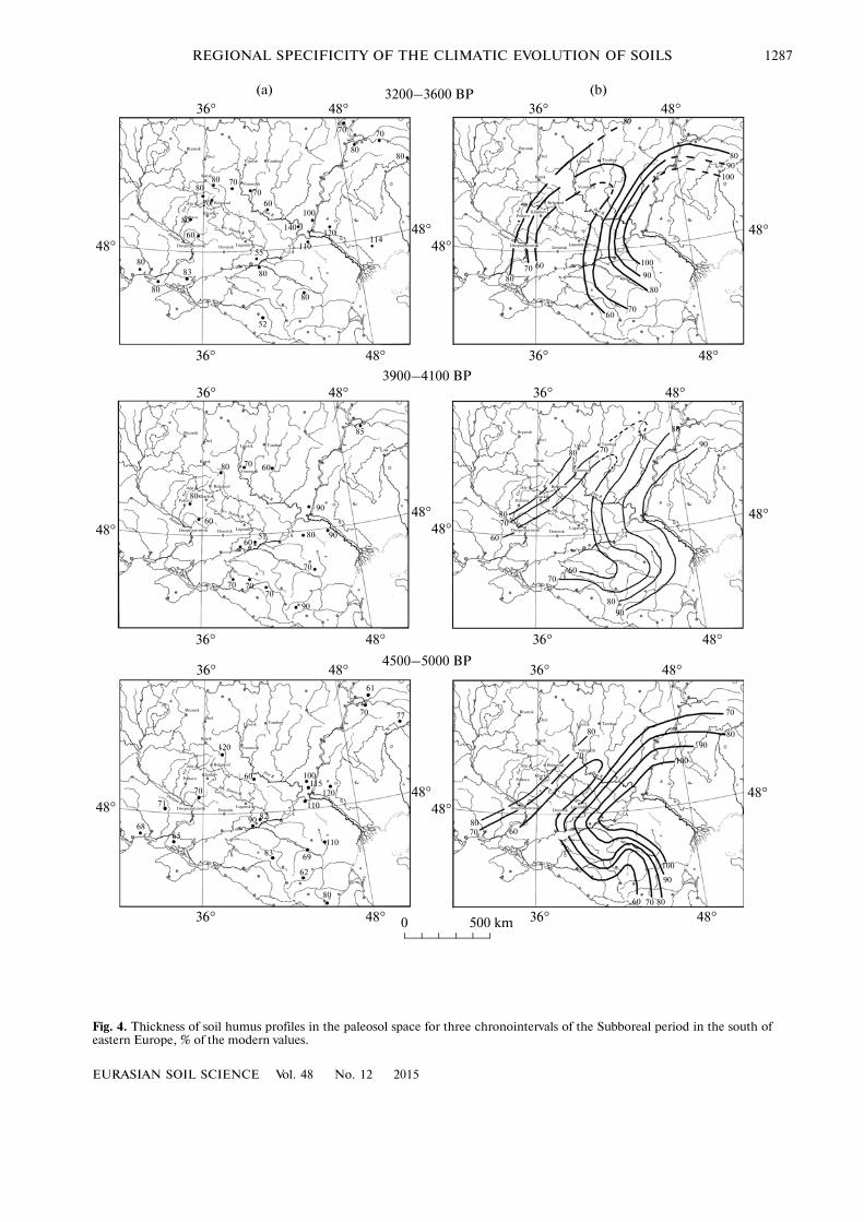
The spatiotemporal regularities of the behavior ofsoil humus profile during the three considered chro�nointervals (Fig. 4) reflect a higher stability of thischaracteristic, its smaller changes both in space and intime in comparison with changes in the depth of soilcarbonates. Within a larger part of the considered ter�ritory, the thickness of the soil humus profiles in theSubboreal period varied within 10% and reached 60–70 or 70–80% of the modern thickness of soil humusprofiles in the corresponding regions. However, ourschematic maps provide valuable information on thefinal stage of the evolution of soil humus profiles thattook place after 3600–3200 BP. Most of the research�ers studying soil evolution in steppe regions of thesouth of eastern Europe argue that the transformationof soil humus profiles was most pronounced at thebeginning of the Subatlantic period [2, 9, 25]. Sche�matic maps clearly display the area with minimal val�ues of the thickness of soil humus profiles extendingfrom the northern Crimea and the Sea of Azov in thenortheastern direction towards the forest�steppe zoneof the Middle Volga region through the middle reachesof the Don River. The genesis of this area is not quiteclear. It can be supposed that its development wasrelated to the transformation of atmospheric circula�tion upon the transition from the Subboreal to theSubatlantic period, which resulted in sharper changesin the soil humus profiles along the “great climatic axisof Eurasia” discovered by Voeikov [8] and later namedafter him [35]. This axis separates the areas with highair pressure and anticyclonic weather conditions to thesouth from the areas of predominant lows and frequentcyclones moving from the southwest and west andbringing precipitation to the north of the axis. Thus,we suggest that the transformation of the climatic sys�tem that shaped the modern landscapes and soils inthe southern part of eastern Europe upon the transi�tion from the Subboreal to the Subatlantic period led
EURASIAN SOIL SCIENCE Vol. 48 No. 12 2015
REGIONAL SPECIFICITY OF THE CLIMATIC EVOLUTION OF SOILS 1289
to the evolution of the humus profiles of chernozems,which was most pronounced in the zone of the bound�ary between different air masses with a width of 200–300 km.
The developed schematic maps of soil characteris�tics for different chronological intervals seem to bepromising for a better understanding of the factors andmechanisms of the evolution of the environment andsoils and, at the same time, for verification and refine�ment of the existing paleoclimatic models. At the sametime, we realize that the density of key points with spe�cial studies of the Holocene evolution of soils is notquite representative for reliable judgment of the regu�larities of the soil cover evolution. With the acquisitionof new data, the suggested patterns of soil evolutioncan be refined.
Our study has confirmed the great theoretical andpractical meaning of the method of soil chronose�quences for the paleosol and paleogeographic recon�structions. A modification of this method as applied forthe compilation and analysis of the schematic maps ofsoil properties in different chronointervals of theHolocene can be referred to as the method of chronoar�eas of soil properties, or, simply, as the method of soilchronoareas.
CONCLUSIONS
(1) During the second half of the Holocene, the soilcover of treeless landscapes in the southern part ofeastern Europe was characterized by the metachro�nous development. The regions with differentlydirected trends of changes in the soil properties andthe regions with enhanced and retarded transforma�tion of the soil properties can be separated. For exam�ple, in the chronointerval from 5000 to 4500 BP, alarge area of soils with enhanced leaching of carbon�ates extended from the Lower Don region to the for�est�steppe zone of the Middle Volga region; the depthsof effervescence in the soils of that time were analo�gous to or deeper than in the modern soils. This factattests to the increased atmospheric moistening of thearea of the Don basin and Middle Volga reaches at thebeginning of the Subboreal period.
(2) The depth of effervescence in the soil profileswas subjected to more pronounced changes under theimpact of climatic fluctuations in comparison withchanges in the thickness of soil humus profiles. In theSubboreal period, the following regional sequences ofevents related to the evolution of soil carbonate pro�files were established: intensive leaching → calcifica�tion → less intensive leaching (Middle and Lower Donbasin and Middle Volga basin), slight calcification →intensive calcification → intensive leaching (LowerVolga basin) → slight calcification → intensive calcifi�cation → slight leaching (southwestern part of the for�est�steppe zone in the Central Russian Upland), andlow�contrasting alternations of the slight leaching and
slight calcification processes within the Poltava Plainand the Prichernomorskaya Lowland.
(3) In the Subboreal period, the thickness of soilhumus profiles in the southern part of eastern Europewas characterized by the low�contrasting variationswithin 60–70 and 70–80% of its modern values. At theend of the Subboreal–the beginning of the Subatlanticperiod, the maximum increase in the thickness of soilhumus profiles took place in the chernozemic zone,within the 200� to 300�km�wide stretch of landextending from the northern Crimea and the Sea ofAzov in the northeastern direction towards the forest�steppe Middle Volga region through the steppe areas ofthe Middle Don basin. This area approximately corre�sponds to the contact zone between the cyclonic andanticyclonic weather regimes along the Voeikov axis.An increase in the amount of precipitation in the con�sidered region at the end of the Subboreal–the begin�ning of the Subatlantic period favored more activegrowth of the thickness of humus horizons of localchernozems in comparison with their analogues onneighboring territories.
ACKNOWLEDGMENTS
This study was supported by the Russian ScienceFoundation, project no. 14�17�00171.
REFERENCES
1. A. L. Aleksandrovskiy, “Evolution of chernozems in theregion of middle stream of the Don River in Holocene,”Pochvovedenie, No. 11, 5–13 (1984).
2. A. L. Aleksandrovskiy and E. I. Aleksandrovskaya, Evo�lution of Soils and the Geographical Environment(Nauka, Moscow, 2005) [in Russian].
3. B. P. Akhtyrtsev and A. B. Akhtyrtsev, “Meadow�cher�nozem paleosols of the Bronze Age in the Oka–Donforest�steppe,” Pochvovedenie, No. 7, 26–38 (1990).
4. B. P. Akhtyrtsev and A. B. Akhtyrtsev, “Paleocher�nozems of the Central Russia forest�steppe in the LateHolocene,” Pochvovedenie, No. 5, 14–24 (1994).
5. N. V. Blagoveshchenskaya, “Holocene dynamics of for�est ecosystems on the upper plateau of the VolgaUpland,” Russ. J. Ecol. 37 (2), 73–78 (2006).
6. A. V. Borisov, N. I. Shishlina, T. S. Demkina,V. A. Demkin, and M. V. El’tsov, “Paleosol studies ofkurgans of the Catacomb culture (second half of thethird millennium BC) in Kalmykia,” Eurasian SoilSci. 38 (2), 123–131 (2005).
7. D. I. Vasil’eva, Candidate’s Dissertation in Biology(Tomsk, 2004).
8. A. I. Voeikov, Climates of the World, Including Russia(Cartographic Office of A. Il’in, St. Petersburg, 1884).
9. A. N. Gennadiev, “Variability of chernozem propertiesover time and evolution of environment (StavropolUpland),” Vestn. Mosk. Univ., Ser. 5: Geogr., No. 5,10–16 (1984).
1290
EURASIAN SOIL SCIENCE Vol. 48 No. 12 2015
CHENDEV et al.
10. A. N. Gennadiev, Soils and Time: Models of Develop�ment (Moscow State University, Moscow, 1990) [inRussian].
11. V. A. Demkin, Paleosol Science and Archeology (Push�chino Scientific Center, Russian Academy of Sciences,Pushchino, 1997) [in Russian].
12. V. A. Demkin, “Paleosol studies of archeological mon�uments in the Sok River valley (Samara region),” Eur�asian Soil Sci. 33 (1), 32–42 (2000).
13. V. A. Demkin and A. V. Lukashev, “Rate and directionof soil�forming processes in the dry steppes inHolocene,” Pochvovedenie, No. 6, 5–14 (1987).
14. V. A. Demkin, T. S. Demkina, L. S. Pesochina, andI. V. Sergatskov, “Paleosol studies of archeologicalmonuments in the Ilovlya River valley,” Pochvovede�nie, No. 3, 19–27 (1994).
15. V. A. Demkin, T. V. Alekseeva, T. S. Demkina, andA. O. Alekseev, “Paleopedological study of a mysteriousmonument of ancient history in the Don River scroll,”Eurasian Soil Sci. 34 (5), 469–478 (2001).
16. V. A. Demkin, T. S. Demkina, M. A. Borisova, andN. I. Shishlina, “Paleosols and paleoenvironment ofthe Southern Ergeni Upland in the end of the fourthand in the third millennia BC,” Eurasian Soil Sci. 35(6), 571–578 (2002).
17. V. A. Demkin, T. S. Demkina, A. V. Borisov, A. S. Yaki�mov, and I. V. Sergatskov, “Transformation of soils andenvironmental conditions in the semidesert low Volgaregion within the past 4000 years,” Eurasian Soil Sci. 37(3), 230–241 (2004).
18. V. A. Demkin, N. N. Kashirskaya, T. S. Demkina,T. E. Khomutova, and M. V. El’tsov, “Paleosol studiesof burial mounds in the Ilovlya River valley (the Priv�olzhskaya Upland),” Eurasian Soil Sci. 41 (2), 115–127 (2008).
19. V. A. Demkin, T. S. Demkina, T. E. Khomutova, andM. V. El’tsov “Soil evolution and climate dynamics indry steppes of the Privolzhskaya Upland during the last3500 years,'' Eurasian Soil Sci. 45 (12), 1095–1109(2012). doi: 10.1134/S1064229312120022
20. T. S. Demkina, A. V. Borisov, and V. A. Demkin,“Paleosols and paleoenvironment in the northernErgeni Upland in the Latest Neolithic and Bronze ages(4–2 ka BC),” Eurasian Soil Sci. 36 (6), 586–598(2003).
21. M. I. Dergacheva, “Archeological soil science: place inthe system of biosphere studies, methodology, and struc�ture,” in Proceedings of the All�Russia Conference onArcheological Soil Science (Pushchino, 2014), pp. 14–16.
22. N. A. Dracheva, Candidate’s Dissertation in Geogra�phy (Moscow, 2002).
23. B. N. Zolotareva and V. A. Demkin, “Humus in paleo�sols of archaeological monuments in the dry steppes ofthe Volga�Don interfluve,” Eurasian Soil Sci. 46 (3),262–272 (2013). doi: 10.7868/S0032180X1306004X
24. V. P. Zolotun, Doctoral Dissertation in Agriculture(Kyiv, 1974).
25. I. V. Ivanov, Evolution of Steppe Soils in the Holocene(Nauka, Moscow, 1992) [in Russian].
26. I. V. Ivanov, “Development of the theories of soil evolu�tion in Russian soil science,” in Proceedings of the IV All�
Russia Conference “Problems of Soil Evolution” (Push�chino, 2003), pp. 5–10.
27. I. V. Ivanov, “Study of soils of the archeological monu�ments: development, scientific theories, and someresults,” in Proceedings of the All�Russia Conference onArcheological Soil Science (Pushchino, 2014), pp. 17–28.
28. I. V. Ivanov and I. B. Vasil’ev, A Man, Nature, and Soilsof the Ryn�Sands on the Volga–Ural Interfluve in theHolocene (Intellekt, Moscow, 1995) [in Russian].
29. I. V. Ivanov and V. A. Demkin, “Soil science and arche�ology,” Eurasian Soil Sci. 32 (1), 91–98 (1999).
30. I. V. Ivanov and E. D. Tabanakova, “Changes in thethickness of humus horizons and the Holocene evolu�tion of East European chernozems (mechanisms, fac�tors, and regularities),” Eurasian Soil Sci. 36 (9), 917–930 (2003).
31. V. A. Klimanov and T. A. Serebryannaya, “Changes ofvegetation and climate in the Central Russian Uplandin the Holocene,” Izv. Akad. Nauk, Ser. Geogr., No. 1,26–37 (1986).
32. K. V. Kremenetskii, T. Bettiger, V. A. Klimanov,A. G. Tarasov, and F. Yunge, “History of climate andvegetation of the Central Volga region in the Late IceAge and Holocene,” in All�Russia Meeting “GeneralResults of the Study of Quaternary and Directions ofStudies in 21st Century,” Abstracts of Papers (All�RussiaScientific Research Geological Institute, St. Peters�burg, 1998), pp. 117–118.
33. P. V. Madanov, L. M. Voikin, A. N. Tyurmenko, et al.,Problems of Paleosol Science and Evolution of Soils of theRussian Plain in the Holocene (Kazan State University,Kazan, 1967) [in Russian].
34. P. V. Madanov, L. M. Voikin, and M. I. Balyanin, “Bur�ied soils under kurgans of the Bronze Age on the Rus�sian Plain,” Pochvovedenie, No. 2, 35–42 (1968).
35. Minor Soviet Encyclopedia (State Publishing of the Rus�sian State Federative Socialistic Republic, Moscow,1940), Vol. 10, pp. 129–130.
36. N. Ya. Margolina, A. L. Aleksandrovskiy, B. A. Il’ichev,et al., Age and Evolution of Chernozems (Nauka, Mos�cow, 1988) [in Russian].
37. L. S. Pesochina, Candidate’s Dissertation in Biology(Moscow, 2004).
38. L. S. Pesochina, “Paleosol studies of Rossiiskii�II kur�gan in Rostov oblast,” in Proceedings of the All�RussiaScientific Conference on Archeological Soil Science(Pushchino, 2014), pp. 144–150.
39. A. M. Prokashev, Soils with Complex Organic Profilefrom the South of Kirov Oblast: Ecology, Properties, andGenesis (Vyatka State Pedagogical University, Kirov,1999) [in Russian].
40. E. A. Spiridonova, Evolution of Vegetation in the DonRiver Basin in the Upper Pleistocene and Holocene(Nauka, Moscow, 1991) [in Russian].
41. E. A. Spiridonova and A. S. Aleshinskaya, “Periods ofNeolith�Eneolith of European Russia using the resultsof palynological analysis,” Ross. Arkheol., No. 1, 23–33 (1999).
42. O. S. Khokhlova, V. Yu. Malashev, K. V. Voronin,A. A. Gol’eva, and A. A. Khokhlov, “Lithogenesis andsoil evolution in the Chechen Depression, Northern
EURASIAN SOIL SCIENCE Vol. 48 No. 12 2015
REGIONAL SPECIFICITY OF THE CLIMATIC EVOLUTION OF SOILS 1291
Caucasus,” Eurasian Soil Sci. 43 (10), 1050–1061(1998).
43. O. S. Khokhlova and A. A. Khokhlov, “Paleosol studiesof Mustaevo V kurgan in Novosergievskii district,Orenburg oblast,” in Archeological Monuments of Oren�burg Oblast (Orenburg State Pedagogical University,Orenburg, 2005), No. 7, pp. 50–69.
44. Yu. G. Chendev, Natural Evolution of Soils in the CentralForest�Steppe in the Holocene (Belgorod State Univer�sity, Belgorod, 2004) [in Russian].
45. Yu. G. Chendev, Evolution of Forest�Steppe Soils of theCentral Russian Upland in the Holocene (GEOS, Mos�cow, 2008) [in Russian].
46. Yu. G. Chendev and I. V. Ivanov, “Dynamics of the soilcover in the southeast of Europe and in the southernTrans�Ural region during the Subboreal period,” Eur�asian Soil Sci. 40 (11), 1158–1168 (2007).
47. Yu. G. Chendev, I. V. Ivanov, O. V. Kovalenko,R. S. Lugovoi, and M. A. Kuropata, “Comparison ofthe Late Holocene evolution of forest�steppe andsteppe chernozems in the center of Eastern Europe,”Probl. Reg. Ekol., No. 2, 26–30 (2011).
48. Yu. G. Chendev, E. G. Ershova, A. L. Aleksandrovskiy,O. S. Khokhlova, A. V. Rusakov, E. V. Ponomarenko,and A. S. Shapovalov, “Paleobotanical and paleosolindicators of evolution of forest�steppe landscape in the
second half of the Holocene: Belgorod oblast,” in Pro�ceedings of the V International Scientific Conference“Problems of Nature Use and Environmental Situation inEuropean Russia and Adjacent Countries” (Konstanta,Moscow, 2013), pp. 201–210.
49. Yu. G. Chendev and V. A. Sarapulkin, “Paleogeo�graphic reconstruction using the study results of theSaltovo�Mayakskaya culture in the Tikhaya Sosna Rivervalley (Belgorod oblast),” in Saltovo�MayakskayaArcheological Culture: Problems and Studies (KharkovScientific Methodological Center of Protection of Cul�tural Heritage, Kharkov, 2012), pp. 96–100.
50. N. I. Shslina and F. T. Khibert, “Eurasian nomads andfarmers of the Bronze Age: problem of interaction,” inBetween Asia and Europe. Caucasus in 4–2 Ka B.C.(St. Petersburg, 1996), pp. 90–92.
51. M. Berkelhammer, A. Sinha, L. Stott, H. Cheng,F. S. R. Pausata, and K. Yoshimura, “An abrupt shiftin the Indian Monsoon 4000 years ago,” Clim., Land�scapes, Civiliz. Geophys. Monogr. Ser. 198, 75–88(2013).
52. H. Weiss, “Desert storm,” Sciences 36 (3), 30–36(1996).
Translated by D. Konyushkov
SPELL: OK