Embed Size (px)
Citation preview

1
Regional Operational Plan CF.4K.2015.08
Pasagshak River Salmon Weir Operational Plan, 2015
by
Mark J. Witteveen
April 2015
Alaska Department of Fish and Game Divisions of Sport Fish and Commercial Fisheries

Symbols and Abbreviations
The following symbols and abbreviations, and others approved for the Système International d'Unités (SI), are used without definition in the following reports by the Divisions of Sport Fish and of Commercial Fisheries: Fishery Manuscripts, Fishery Data Series Reports, Fishery Management Reports, and Special Publications. All others, including deviations from definitions listed below, are noted in the text at first mention, as well as in the titles or footnotes of tables, and in figure or figure captions. Weights and measures (metric) centimeter cm deciliter dL gram g hectare ha kilogram kg kilometer km liter L meter m milliliter mL millimeter mm Weights and measures (English) cubic feet per second ft3/s foot ft gallon gal inch in mile mi nautical mile nmi ounce oz pound lb quart qt yard yd Time and temperature day d degrees Celsius °C degrees Fahrenheit °F degrees kelvin K hour h minute min second s Physics and chemistry all atomic symbols alternating current AC ampere A calorie cal direct current DC hertz Hz horsepower hp hydrogen ion activity pH (negative log of) parts per million ppm parts per thousand ppt, ‰ volts V watts W
General Alaska Administrative Code AAC all commonly accepted abbreviations e.g., Mr., Mrs.,
AM, PM, etc. all commonly accepted professional titles e.g., Dr., Ph.D., R.N., etc. at @ compass directions:
east E north N south S west W
copyright corporate suffixes:
Company Co. Corporation Corp. Incorporated Inc. Limited Ltd.
District of Columbia D.C. et alii (and others) et al. et cetera (and so forth) etc. exempli gratia (for example) e.g. Federal Information Code FIC id est (that is) i.e. latitude or longitude lat. or long. monetary symbols (U.S.) $, ¢ months (tables and figures): first three letters Jan,...,Dec registered trademark trademark United States (adjective) U.S. United States of America (noun) USA U.S.C. United States
Code U.S. state use two-letter
abbreviations (e.g., AK, WA)
Mathematics, statistics all standard mathematical
signs, symbols and
abbreviations alternate hypothesis HA base of natural logarithm e
catch per unit effort CPUE coefficient of variation CV common test statistics (F, t, 2, etc.) confidence interval CI correlation coefficient (multiple) R correlation coefficient (simple) r covariance cov degree (angular ) ° degrees of freedom df expected value E
greater than > greater than or equal to harvest per unit effort HPUE less than < less than or equal to logarithm (natural) ln logarithm (base 10) log logarithm (specify base) log2, etc. minute (angular) ' not significant NS null hypothesis HO percent % probability P probability of a type I error (rejection of the null hypothesis when true) probability of a type II error (acceptance of the null hypothesis when false) second (angular) " standard deviation SD standard error SE variance population Var sample var
REGIONAL OPERATIONAL PLAN CF.4K.2015.08
PASAGSHAK RIVER SALMON WEIR OPERATIONAL PLAN, 2015
by
Mark J. Witteveen
Alaska Department of Fish and Game, Division of Commercial Fisheries, Kodiak
Alaska Department of Fish and Game Division of Commercial Fisheries
April 2015

25
The Regional Operational Plan Series was established in 2012 to archive and provide public access to operational plans for fisheries projects of the Divisions of Commercial Fisheries and Sport Fish, as per joint-divisional Operational Planning Policy. Documents in this series are planning documents that may contain raw data, preliminary data analyses and results, and describe operational aspects of fisheries projects that may not actually be implemented. All documents in this series are subject to a technical review process and receive varying degrees of regional, divisional, and biometric approval, but do not generally receive editorial review. Results from the implementation of the operational plan described in this series may be subsequently finalized and published in a different department reporting series or in the formal literature. Please contact the author if you have any questions regarding the information provided in this plan. Regional Operational Plans are available on the Internet at: http://www.adfg.alaska.gov/sf/publications/
Mark J. Witteveen,
Alaska Department of Fish and Game, Division of Commercial Fisheries,
351 Research Court, Kodiak, AK 99615, USA
This document should be cited as:
Witteveen, M. J. 2015. Pasagshak River salmon weir operational plan, 2015. Alaska Department of Fish and Game,
Division of Commercial Fisheries, Regional Operational Plan ROP.CF.4K.2015.08, Kodiak.
The Alaska Department of Fish and Game (ADF&G) administers all programs and activities free from discrimination based on race, color, national origin, age, sex, religion, marital status, pregnancy, parenthood, or disability. The department administers all programs and activities in compliance with Title VI of the Civil Rights Act of 1964, Section 504 of the Rehabilitation Act of 1973, Title II of the Americans with Disabilities Act (ADA) of 1990, the Age Discrimination Act of 1975, and Title IX of the Education Amendments of 1972.
If you believe you have been discriminated against in any program, activity, or facility please write: ADF&G ADA Coordinator, P.O. Box 115526, Juneau, AK 99811-5526
U.S. Fish and Wildlife Service, 4401 N. Fairfax Drive, MS 2042, Arlington, VA 22203 Office of Equal Opportunity, U.S. Department of the Interior, 1849 C Street NW MS 5230, Washington DC 20240
The department’s ADA Coordinator can be reached via phone at the following numbers: (VOICE) 907-465-6077, (Statewide Telecommunication Device for the Deaf) 1-800-478-3648,
(Juneau TDD) 907-465-3646, or (FAX) 907-465-6078 For information on alternative formats and questions on this publication, please contact:
ADF&G, Division of Sport Fish, Research and Technical Services, 333 Raspberry Rd, Anchorage AK 99518 (907) 267-2375

i

ii

iii
TABLE OF CONTENTS Page
LIST OF FIGURES ...................................................................................................................................................... iv
PURPOSE...................................................................................................................................................................... 1
Background .................................................................................................................................................................... 1
OBJECTIVES ................................................................................................................................................................ 2
METHODS .................................................................................................................................................................... 2
Weir Installation ............................................................................................................................................................ 4
Weir Operation .............................................................................................................................................................. 5
Weir Maintenance.......................................................................................................................................................... 6
Weir Removal ................................................................................................................................................................ 6
Escapement Sampling .................................................................................................................................................... 7
Subsistence Fishery Sampling ....................................................................................................................................... 7
Other Requirements ....................................................................................................................................................... 7
Daily Contact Schedule ............................................................................................................................................ 7 Daily Forms .............................................................................................................................................................. 7 Timesheets ................................................................................................................................................................ 7 Season Summary Report ........................................................................................................................................... 7
Additional Guidelines and Procedures .......................................................................................................................... 8
Camp Policies ........................................................................................................................................................... 8 Food and Supplies ..................................................................................................................................................... 8 Visitors/Public Interaction ........................................................................................................................................ 8 Garbage ..................................................................................................................................................................... 8 First Aid and Fire Safety ........................................................................................................................................... 8 Drinking Water ......................................................................................................................................................... 9 All-Terrain Vehicles ................................................................................................................................................. 9 Maintenance .............................................................................................................................................................. 9 Compliance with ADF&G Regulations .................................................................................................................... 9 Violations .................................................................................................................................................................. 9 Emergencies ............................................................................................................................................................ 10
SCHEDULE AND DELIVERABLES ........................................................................................................................ 10
RESPONSIBILITIES .................................................................................................................................................. 11
REFERENCES CITED ............................................................................................................................................... 12
FIGURES .................................................................................................................................................................... 13

iv
LIST OF FIGURES
Figure Page 1. Map depicting the location of Pasagshak River Weir, 2015.......................................................................... 14 2. Aerial view of Pasagshak River State Recreation Area. ................................................................................ 15 3. Historical estimated sockeye salmon escapement and sport and subsistence harvest at Pasagshak River. ... 16 4. Historical sockeye salmon subsistence harvest estimates for three important subsistence systems near
the City of Kodiak (2014 data was not available at the time of the publication). .......................................... 17 5. Pasagshak weir construction showing tripod counting gate, and sign placement. ........................................ 18 6. Pasagshak weir showing bank, stream gauge, and trap placement. ............................................................... 19 7. An example of an upstream live trap. ............................................................................................................ 20 8. Subsistence fishery interview form. .............................................................................................................. 21 9. Daily weir counting form. ............................................................................................................................. 22 10. Daily physical observation form. .................................................................................................................. 23 11. Weekly weir camp reporting form. ............................................................................................................... 24

1
PURPOSE
From 2011 to 2015, sockeye salmon Oncorhynchus nerka escapement through the Pasagshak River into Lake Rose Teed on the Kodiak road system was and will be estimated with a weir. The Alaska Department of Fish and Game (ADF&G), Division of Commercial Fisheries will operate the aluminum picket and wood tripod salmon weir near the mouth of Lake Rose Teed. Age, sex, and length (ASL) information will be gathered from sockeye salmon captured at the weir. Subsistence fishing activity will be observed and ASL information will be gathered from subsistence catch. This information will assist ADF&G staff in determining appropriate escapement levels into Lake Rose Teed and to more effectively monitor the timing, health, and productivity of Lake Rose Teed sockeye salmon. This operational plan will provide seasonal employees a reference document in order to run the field camp effectively, operate the weir, and live safely at the remote site during the 2015 season. Key words: Lake Rose Teed, Pasagshak River, sockeye salmon, Oncorhynchus nerka, weir, escapement, Kodiak Management Area, KMA, field camp operational plan.
BACKGROUND
The Pasagshak River, located on the Kodiak road system (Figures 1 and 2), has supported the largest sockeye salmon subsistence fishery for Kodiak Island residents in several of the past ten years 1 (Figures 3 and 4). Since 1998, subsistence harvest of Pasagshak River sockeye salmon has increased while escapement estimates have been widely variable with relatively low estimates during 2009, 2010, 2012 and 2014. Previous escapement enumeration methodology provided only postseason estimates via aerial and foot surveys of the spawning grounds, making inseason subsistence and sport fisheries management impossible and refinement of an escapement goal for this stock problematic. A conventional aluminum picket weir will be constructed near the outlet of the lake in 2015 (similar to 2011 through 2014) and will provide timely and accurate escapement information, enabling inseason management adjustments and more precise evaluation of the escapement goal to maintain the sustainability of this important subsistence, commercial, and sport salmon run.
The Pasagshak River is located on the northeast side of Kodiak Island and is accessible by car from the city of Kodiak (Figure 1). Lake Rose Teed, which drains into the Pasagshak River, is a small, shallow lake (0.94 km2; 2.1 m average depth). Prior to the 1964 earthquake and subsequent tsunami, Lake Rose Teed had little salmon rearing habitat; however, the earthquake lowered the elevation of the lake, allowing nutrient rich marine water to enter the lake during high tide cycles and dramatically increasing the salmon rearing potential (Murray 1986). Pasagshak River State Recreational Site is the only designated park land outside of the immediate city area and still within the road system (Figures 1 and 2). The mouth of the Pasagshak River is also a prehistoric native settlement site.
Since 1968, Pasagshak River salmon escapement has been estimated post-season using both aerial and foot surveys of the spawning grounds. Although annual survey counts have been highly variable, sockeye salmon production has generally increased since that time (Figure 3). The current escapement goal for Pasagshak River sockeye salmon is a lower-bound SEG of 3,000 fish based on aerial survey (Sagalkin et al. 2013).
1 J. Shaker, Fish and Wildlife Technician III, ADF&G, Kodiak, unpublished data.

2
Subsistence harvest of this salmon stock has been generally increasing since subsistence records were initiated in 1986. From 2008 to 2011, the Pasagshak River was the largest subsistence salmon fishery in the Kodiak Management Area (KMA) (Figure 4)2. During some years in the past decade, two other significant sockeye salmon runs near the City of Kodiak, Afognak and Buskin lakes, have experienced significant reductions in run size, restricted fishing opportunities and, during some years, total subsistence fishing closures (Baer et al. 2009; Dinnocenzo 2010; Dinnocenzo et al. 2010; Jackson et al. 2010). Such restrictions on those stocks can displace users to other systems (Magdanz et al. 2003), leading to concern that Pasagshak River sockeye salmon will experience increased harvest pressure while ADF&G is unable to monitor escapement inseason.
There is little directed commercial fishing effort on Pasagshak River sockeye salmon. Some Pasagshak River fish are likely harvested by commercial fishermen targeting nearby Saltery River sockeye salmon. While harvest levels are unknown, they are likely low as the fishery in front of the Saltery River is further inside Ugak Bay than Pasagshak River. Sport harvests are substantially smaller in magnitude than subsistence harvests, but appear to track the same trends and likely vary due to similar factors as the subsistence fishery (Figure 3).
Inseason estimates of Pasagshak River sockeye salmon escapement are possible with a weir near the outlet of Lake Rose Teed. The escapement data obtained by use of a weir, coupled with age, sex, and length (ASL) data, provides dependable, timely estimates of stock productivity and sockeye salmon run size. Accurate run data coupled with ASL data will be used to refine the current escapement goal.
In addition to the installation and annual operation of escapement monitoring techniques, important information on subsistence and sportfish effort at the Pasagshak River can be obtained through harvester interviews conducted by ADF&G technicians. ASL data obtained from subsistence harvests will augment ASL data obtained from weir traps, and provide valuable information on the harvest composition, size selectivity, and magnitude relative to escapement.
This operational plan is a reference and guiding document for the field staff, so that they understand what is expected of them to effectively accomplish the required tasks and duties of the project. Project activities at Pasagshak River weir will include installation and maintenance of a weir and the collection of biological samples (i.e., scales for age, sex, and length).
OBJECTIVES
1. Census passage of Pasagshak River system sockeye salmon escapement from June 15 to August 15.
2. Estimate the age, sex, and length (ASL) composition of Pasagshak River sockeye salmon escapement.
3. Describe inseason harvest, timing, ASL, and effort of subsistence fisheries for Pasagshak River sockeye salmon.
METHODS
A tripod and aluminum picket weir will be constructed and installed at a suitable location approximately 0.5 miles from the outlet of Lake Rose Teed. Tripods and sand bags are stored
2 J. Shaker, Fish and Wildlife Technician III, ADF&G, Kodiak, unpublished data.

3
at the ranch near Lake Rose Teed while the aluminum pickets are stored at the Alaska Department of Fish and Game warehouse.
The project supervisor will train technicians in proper species identification of sockeye, pink O. gorbuscha, chum O. keta, and coho salmon O. kisutch and Dolly Varden Salvelinus
malma, the species expected to be encountered at the weir. Technicians will monitor the weir daily between approximately 7:00 AM and 10:00 PM and enumerate salmon by species by visually enumerating them through a counting gate built into the weir and record the counts with tally counters. Escapement counts will be reported to the project leader on a daily basis.
A trap will be constructed as part of the weir to capture sockeye salmon fore sampling. The sample goal is 240 per week sockeye salmon during 2015 for ASL in proportion to the escapement. The “preferred scale” (located on the left side of the fish, two rows above the lateral line on the diagonal from the posterior insertion of the dorsal fin to the anterior insertion of the anal fin) will be removed with forceps and mounted on a gum card. The sex and length of the fish (fish length in millimeters from mid eye to tail fork) will be recorded to rugged digital assistants and the data will be downloaded to laptop computers daily. Detailed procedures for sampling can be found in Wattum (In prep). Samples will be collected each Wednesday, Friday, and Monday in approximate proportion to the escapement levels. If it is obvious to the crew leader that fish are not being captured in the trap in proportion to the escapement, scheduling adjustments will be made to sample more fish. The crew leader should also observe fish behavior while entering the trap and experiment to see if modifications can be made to improve the efficiency of the trap. The crew will be trained for proper sampling procedure and the samples will be periodically checked throughout the season for accuracy and completeness.
Scales will be read for age composition post season. These samples provide the foundation for escapement goal evaluation and measurement of sockeye salmon productivity within Lake Rose Teed and its tributaries.
Traditional areas of subsistence harvest and level of effort at Pasagshak River will be documented. ADF&G technicians will opportunistically contact sockeye salmon subsistence fishermen on the fishing grounds in front of the Pasagshak River, and alternatively at the Pasagshak State Recreation Area boat landing. Following a set of brief introductory remarks by the technician, all subsistence users who agree to be interviewed will be asked a short series of questions to determine their traditional subsistence fishing location(s) (e.g., Pasagshak River, Buskin River or elsewhere), likely location of subsistence fishing in the near future, and level of effort at Pasagshak River. An effort will be made to conduct interviews in a weekly quantity proportional to subsistence effort. It is anticipated that approximately 150 such interviews will be conducted throughout the duration of the subsistence fishery, providing a representative sample of subsistence effort.
The sockeye salmon harvested by interview participants will be sampled for ASL data if the fish are available to sample. These data will be used to test whether age and sex compositions of subsistence sockeye salmon harvests are similar to age and sex compositions of sockeye salmon passing the weir so the entire run can accurately be reconstructed. The total Pasagshak River subsistence harvest will be estimated based on returns of completed permits received by the Westward Region Division of Commercial Fisheries office when those data

4
are available. Annual return rates of completed permits are usually between 85% and 90% of participants.3
A daily log will be kept by the crewleader including notes about the weir, notable occurrences, and subsistence fishing effort.
The maximum observed number of subsistence boats fishing within Pasagshak Bay will be recorded in the daily log book on a daily basis.
WEIR INSTALLATION
Pasagshak River weir will be approximately 150 feet long.
1. Align the first and last tripods on either side of the river perpendicular to the river flow.
2. String a taught line (use seine twine) across the river attached to the front of the two tripods. Move the remaining tripods in place with the back legs touching the adjacent tripod and the front leg barely touching the taught line. Square the tripods perpendicular to the upstream river flow. The last tripod may have to be further adjusted for correct tripod spacing.
3. Fine- tune tripod spacing and leveling. Level each tripod by digging under the highest rear leg to level it out. Leveled tripods make it easier to install and level the boardwalk. Place a minimum of ten sandbags on each tripod platform.
4. Install the entire boardwalk on the posterior portion of the tripod arms. Start at one end of the weir laying a 2” x 12” x 12’ board across the first set of tripod arms ensuring it rests on the next consecutive tripod arm. Continue laying out the boardwalk the length of the weir (Figure 5).
5. Level the boardwalk with spacers or leveling blocks nailed to the tripod arm and fine-tune the straightness of the boardwalk. Toenail the boardwalk to tripod arms and toenail the boards that overlap one another together with 16d duplex nails. Make sure the end of each individual board rests on a tripod arm. A sturdy boardwalk will limit the risk of personnel falling into the water.
6. Install upper and lower stringers in an alternating pattern across all tripods. At both stream banks drive the upper and lower stringers partially into the stream bank for stability or sandbag them in place if the bank isn’t steep enough.
7. Begin installing weir panels at one bank. Lay each panel flat against the stringers with the base of the panel up off the riverbed approximately 10 inches. Rake and dig a channel in the river bottom to set the panel into. Once a channel is dug, set the panel into the channel and make sure it is straight and level. Next, backfill the channel with stream gravel and rock to ensure it is fish tight. The first (and last) panel may require minute bank modifications and sandbags to fill gaps. Continue setting weir panels the length of the weir.
8. Install two counting gate frames along with your weir panels. One of the gates is for counting and the other one is for the trap. The counting gate should be located in an area of the weir that is expected to have strong consistent flow at all tides and the area that is most likely to pass fish. The trap gate should be located in a similar location that is anticipated to promote consistent fish passage.
3 J. Shaker, Fish and Wildlife Technician III, ADF&G, Kodiak, personal communication.

5
9. Install flash panels in front of and against the counting gate on the river bottom and weigh down with large rocks or sandbags.
10. Install a continuous line of sandbags along the bottom in front of the panels to prevent scouring.
11. Use lag bolts to attach “Telespar” across the front of the panels, bolting into the front leg of the tripods. Use two rows of telespar across the deepest sections of water.
12. Install “keep off weir” sign, stream gauge, and counting seats (Figures 5 and 6).
13. Inspect your work. Walk along the front of the weir backfilling the base of panels where necessary to ensure the weir is fish tight.
14. Install the upstream fish trap at the fish trap gate using six foot panels to form a “box” on the upstream side of the gate with entrance deflectors to restrict fish passage to a small area (Figure 7). Use wire or tie straps to affix the sides, front, and deflectors together. Use additional panels or vexar fill in the triangular opening between the trap and front of weir. Backfill gravel at the bottom of all panels to ensure the trap is fish tight.
15. Observe fish behavior behind the weir and make any adjustments or relocations to the trap and counting gate to try to maximize capture and/or passage of fish.
WEIR OPERATION
1. Monitor the weir throughout the day to pass fish. Mornings and evenings are expected to be the best times for fish passage, but passage may be highly dependent on tides. Crew members will organize a schedule of counts relative to river conditions or rate of salmon passage. Counting schedules will likely change throughout the season due to the changes in the tidal cycle. If fish readily pass on a given count, the subsequent count should be two hours later or less. If fish are reluctant to pass, the subsequent count can be as long as three hours later. If water conditions such as strong upstream current or high debris load threaten the integrity of the weir, check it more often.
2. If you don’t have experience identifying fish, your project leader or designee will train you to visually recognize the different salmon species and their swimming patterns. When fish have accumulated behind the weir, take time to visually study them and note differences as they pass through the weir.
3. Begin counting fish by opening a gate and enumerating with handheld tally counters, one for each species. Monitor escapement quality, including the numbers of net-marked, “jack” (salmon ≤400 mm mideye to tail fork) sockeye salmon, occurrence of fungus on fish, and number of fish with seal bites.
4. If a counting gate will not open, it is probably locked up by gravel or a rock wedged into the framework. Do not attempt to force the gate, or the entire framework may pull out of place along with the flash panel. Free up the gate by inspecting for wedged rock or gravel and removing it with your fingers or a fish pew.
5. When counting fish and conducting surveys, wear polarized glasses for greater visual recognition and eye protection from the sun’s reflection off of the water.
6. Periodically check your tally counters to ensure they are working properly.
6
7. When finished counting, make sure the counting gate is closed completely.
WEIR MAINTENANCE
1. The weir must be cleaned and inspected daily. Debris buildup on the weir may cause poor water flow, leading to scouring at the base of weir panels and weir washout during periods of high water.
2. Cleaning the weir includes getting into the river to remove sticks, logs, leaves, grass, gravel, fish carcasses, and garbage.
3. Throw all debris (except garbage) over the weir.
4. Inspect the weir to ensure it is fish tight, look for scoured holes, panels out of place, gaps between panels (wide enough to fit your hand past your palm through), sandbags that have been pushed off of tripods by bears, and make sure flash panels are in place and secure. Make repairs if needed.
5. Make sure the framework of the weir is sound and secure. If you find any of the boardwalks loose or any section or parts of the weir broken by bears or unsafe, repair them immediately.
6. If the water level increases to the point where the bottom of the sandbags on the tripod platform are in the water, weir panels and the trap may need to be pulled to avoid a weir wash out. If a weir wash out is possible, closely monitor fish build-up below the weir for fish passage estimation. If pulling the weir is needed, pull the trap and the gates (keeping the weir clean also lowers the water level). If the visibility allows, count fish passing through the gates. If the water level continues to rise, pull panels from the center of the weir or where the current is the greatest.
7. Keep bears and ungulates away and off of the weir as much as possible to minimize damage.
8. Do not allow members of the public to walk on to the weir.
9. If, upon arriving at the weir, you observe a hole through which fish are escaping, spend 10 minutes or so observing the rate of escaping fish so that you have some information to base an estimate of escaped fish upon. After determining the fish passage rate, repair the hole in the weir as soon as safely possible.
WEIR REMOVAL
1. Remove the fish trap, stream gauge, and “keep off weir” signs.
2. Cut and remove all seine twine or cable ties attaching the weir panels to the upper stringers.
3. Remove all weir panels, counting gates, and flash panels.
4. Remove all upper and lower stringers.
5. Remove most (leave two or three depending on water flow) sandbags from tripods.
6. Remove all duplex nails securing the boardwalk and then move all sections of the boardwalk.
7. Remove all remaining sandbags and tripods.
8. Remove all sandbags from the river.

7
ESCAPEMENT SAMPLING
Throughout the season, sample sockeye salmon passing through the trap at Pasagshak River weir for ASL data. If fish are available, sample 240 sockeye salmon weekly during the season for ASL. The exact number of samples collected will be dependent on the run strength. Refer to Wattum (In prep) for procedures on how to sample adult salmon properly. Ask the project supervisor if you have any questions. The trap may require adjustment or relocation to effectively capture fish. Observe fish behavior behind the weir and where they tend to hold to determine which adjustments to make. An effective trap may require some experimentation.
SUBSISTENCE FISHERY SAMPLING
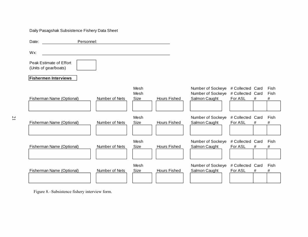
Quantify the amount of subsistence gillnet fishing effort that takes place in the ocean daily. At a minimum of three times per week, attempt to contact fishermen as they finish fishing for the day and document their fishing location, effort, and harvest levels. Request access to subsistence-caught fish to gather ASL data. Sample up to 80 fish per day or at least 240 fish per week as available. Fill out a Subsistence Fishery Interview Form (Figure 8).
OTHER REQUIREMENTS
Daily Contact Schedule Field camp crews are required to contact ADF&G Kodiak Research office personnel daily. Unless otherwise agreed upon, Pasagshak River weir personnel will contact the Kodiak Salmon Management Office at 907-486-1851 between 0800 and 0815 hours (8:00–8:15 AM) daily to report escapement data. All other camp business will be reported to Kodiak Salmon Research staff (Mark Witteveen) at 907-942-2233 by cell phone call or text. If contact cannot be made, Kodiak ADF&G office personnel will contact the camp as soon as possible.
Daily Forms Any crew member who counts fish through the weir will immediately fill in the counts on the Daily Weir Counting Form (Figure 9). A crew member will fill out a Daily Physical Observation
Form (Figure 10), a Weekly Weir Camp Reporting Form (Figure 11), and maintain a camp log (“rite in the rain” booklet) every day. The Weekly Weir Camp Reporting Form includes daily escapement data that occurred during the past week and total cumulative counts that are continued from previous weeks.
A daily log of each day’s activities and observations will be kept by the crew leader. Observations of subsistence effort will be kept in the daily log.
Timesheets Each crew member will have a timesheet completed and turned into the office by the 15th and the last day of each month. Each crew member is responsible for keeping an accurate record of their work hours. Timesheets need to be sent into town when the camp is re-supplied. Field crew must plan ahead to ensure that timesheets are completed prior to re-supply. If unusual circumstances arise that require overtime, the crew leader must notify the project leader immediately.
Season Summary Report The crew leader is responsible for writing a brief end of season summary report. The report will summarize weekly activities, sampling, problems with the weir, an inventory of tools and

8
supplies, and suggested improvements or needs for the next field season. Keep a daily log of project activities in the camp log for reference.
ADDITIONAL GUIDELINES AND PROCEDURES
Camp Policies Alcoholic beverages are not to be stored or consumed in areas open to public view. If alcohol
is consumed at a camp the employee must be 21 years of age or older and off work without any duty scheduled for the remainder of the day and under no circumstances shall he or she engage in the operation of any State equipment, nor shall he or she return to duty status under the influence of alcohol. The abuse of alcoholic beverages will be grounds for immediate dismissal.
All employees will be required to act in a professional manner at all times and be especially courteous to the public.
Injuries must be reported to the project supervisor immediately.
Loss or damage of equipment must be reported to the project supervisor within 24 hours.
Food and Supplies Field crews will purchase all essential items prior to leaving Kodiak. One crew member can return to the City of Kodiak at a time to purchase food and supplies. Please attempt to keep trips to a minimum, on the order of once per week. Communicate with the project leader as to when a trip to town is scheduled. The camp may also be resupplied by staff headed out to the Pasagshak River, so maintain a list of needed items so you can pass it along to the Project Supervisor before other personnel travel to the weir site.
Alcoholic beverages, personal grooming supplies, newspapers, magazines, and tobacco must be purchased with personal funds.
Visitors/Public Interaction The weir site will get many visitors. Visitors come by the weir site to watch fish passing through the weir and ask about fish passage. Keep the weir site clean and be courteous and helpful to visitors, but also inform them of the boundaries. THE GENERAL PUBLIC IS NOT
ALLOWED TO ACCESS THE WEIR. Make sure the “keep off weir” sign is posted in a visible location. Also, make sure the public is aware that there is a “No fishing” sanctuary 100 yards above and 100 yards below the weir. Ensure that those signs remain in place. Remember, your primary role is to operate and maintain the weir and accomplish the associated responsibilities of the project. Under no circumstance should any employee accept gratuities or payment.
Garbage Maintain a clean camp to avoid attracting bears. Do not allow garbage to accumulate or leave it outside of the cabin.
First Aid and Fire Safety All crew members will take a mandatory CPR and First Aid training course prior to going in the field. The project leader will ensure a fully stocked first aid kit and fully charged, operable fire

9
extinguishers are in camp, and that all personnel know where they are located and how to use them. Make sure smoke and carbon monoxide alarms are installed and operational.
Drinking Water Stream and lake water may be contaminated with bacteria or harmful parasites. Haul water from the State Park pump for drinking and cooking water. If clean water is not available, boil your drinking water for at least 10 minutes.
All-Terrain Vehicles The Pasagshak River weir camp will be furnished with an All-Terrain Vehicle (ATV; 4-wheeler). The ATV has been provided to transport materials and personnel from the cabin to the weir site. It is not intended for personal use or recreational purposes. The ATV may be accessed and operated only by trained personnel and will be secured when not in use. Be safety conscious at all times; do not speed or drive recklessly.
Unauthorized use of the ATV will result in a notation on your evaluation or your dismissal from employment. A safety helmet must always be worn when riding the ATV.
Maintenance Facility maintenance is an important aspect of camp life; the cabin and weir must be kept structurally sound and safe. Discuss maintenance projects with the project leader. Provide a list of materials needed to accomplish the projects and repairs to your project leader. Repairs and maintenance should be scheduled on days when fish passage is slow to keep this work within normal work periods.
The ATV must be kept in good operating condition and will require regular maintenance. At the end of each season, equipment should be winterized and tagged with a description of the equipment’s condition on the tag.
Compliance with ADF&G Regulations All employees are responsible for complying with local subsistence, sport fishing, and hunting regulations. Copies of State and Federal regulations will be available to all field camp personnel and kept in camp. Any violation will be recorded on your evaluation and may be cause for immediate dismissal.
Violations If a fishing violation is observed, all information pertaining to the violation should be recorded immediately and retained by the employee. The project leader must be notified. If you have a camera, record as much as possible.

10
Emergencies In the event of a medical emergency, administer first aid to stabilize the situation. If an injury is life threatening immediately call 911 or notify the US Coast Guard at 800-478-5555 on the telephone. The US Coast Guard can also be reached on SSB radio frequency 4.125 MHz or on VHF channel 16.
When contacting the U.S. Coast Guard, have the following information ready to pass along:
Location of your field camp or specific location of the emergency (57°28’24.64”N, 152°27’47.12”W),
Name and phone number of supervisor, General nature of medical emergency, Number of patients, Specific information regarding the patient (name, age, primary complaint, and vital signs), Your assessment and treatment, Wind and weather conditions, and Other information pertinent to a possible medical evacuation.
SCHEDULE AND DELIVERABLES
1. Open camp and install weir. Target date: June 15.
2. Enumerate salmon escapement through Pasagshak River weir. Target dates: June 15–August 15.
3. Collect approximately 200 ASL samples from the sockeye salmon escapement in proportion to the relative weekly abundance. Target dates: June 15–August 15.
4. Collect physical data daily: air and water temperature, and weather observations. Target dates: June 15–August 15.
5. Communicate daily with Kodiak ADF&G personnel by cellular telephone. 6. Inventory and secure Pasagshak River weir camp and close down for the season.
Target Date: August 15.

11
RESPONSIBILITIES
The project biologist, Mark Witteveen, will be responsible for project supervision, which will include: providing training, oversight, logistical, and technical support for the camp operation. The two crew members will be responsible for establishing work schedules, prioritizing daily work assignments, and supervising camp duties. They are also responsible for ensuring that accurate, complete, and well-organized data are collected, as well as ensuring safety.
12
REFERENCES CITED
Baer, R. T., S. T. Schrof, M. B. Foster, and S. G. Honnold. 2009. Stock assessment and restoration of the Afognak Lake sockeye salmon run, 2008. Alaska Department of Fish and Game, Fishery Data Series No. 09-37, Anchorage.
Dinnocenzo, J. 2010. Kodiak Management Area commercial salmon fishery annual management report, 2008. Alaska Department of Fish and Game, Fishery Management Report No. 10-02, Anchorage.
Dinnocenzo, J., G. Spalinger, and I. O. Caldentey. 2010. Kodiak Management Area commercial salmon fishery annual management report, 2009. Alaska Department of Fish and Game, Fishery Management Report No. 10-22, Anchorage.
Jackson, J., J. Dinnocenzo, and G. Spalinger. 2010. Kodiak Management Area commercial salmon fishery annual management report, 2010. Alaska Department of Fish and Game, Fishery Management Report No. 10-47, Anchorage.
Magdanz, J. S., S. Tahbone, K. Kamletz, and A. Ahmasuk. 2003. Subsistence salmon fishing by residents of Nome, Alaska, 2001. Alaska Department of Fish and Game. Technical Paper 274, Fishery Information Services Project 01.224.
Wattum, M. L. In prep. Kodiak Management Area salmon catch and escapement sampling operational plan, 2015. Alaska Department of Fish and Game, Division of Commercial Fisheries, Regional Operational Plan, Kodiak.
Murray, J. B. 1986. Annual Performance report for Pasagshak River Chinook salmon development. Alaska Department of Fish and Game, Division of Sport Fish, Anchorage.
Sagalkin, N. H., M. B. Foster, M. B. Loewen, and J. W. Erickson. 2013. Review of salmon escapement goals in the Kodiak Management Area, 2013. Alaska Department of Fish and Game, Fishery Manuscript Series No. 13-11, Anchorage.

13
FIGURES

14
Figure 1.–Map depicting the location of Pasagshak River Weir, 2015.

15
Figure 2.–Aerial view of Pasagshak River State Recreation Area.

16
Note: In 2011-2014, escapement was estimated via weir; prior to that escapement was estimated via aerial survey.
Figure 3.–Historical estimated sockeye salmon escapement and sport and subsistence harvest at Pasagshak River.
0
10,000
20,000
30,000
40,000
50,000
60,000
19
68
19
69
19
70
19
71
19
72
19
73
19
74
19
75
19
76
19
77
19
78
19
79
19
80
19
81
19
82
19
83
19
84
19
85
19
86
19
87
19
88
19
89
19
90
19
91
19
92
19
93
19
94
19
95
19
96
19
97
19
98
19
99
20
00
20
01
20
02
20
03
20
04
20
05
20
06
20
07
20
08
20
09
20
10
20
11
20
12
20
13
20
14
Nu
mb
er
of
So
cke
ye S
alm
on
Year
Escapement
Subsistence Harvest
Sport Harvest

17
Figure 4.–Historical sockeye salmon subsistence harvest estimates for three important subsistence systems near the City of Kodiak
(2014 data was not available at the time of publication).
0
5,000
10,000
15,000
20,000
25,000
30,000
1990 1991 1992 1993 1994 1995 1996 1997 1998 1999 2000 2001 2002 2003 2004 2005 2006 2007 2008 2009 2010 2011 2012 2013
Num
be
r o
f S
ocke
ye
Sa
lmo
n
Year
Settler's Cove
Afognak
Buskin
Pasagshak

18
Figure 5.–Pasagshak weir construction showing tripod counting gate and sign placement.
Counting Gate
Weir Sign

19
Figure 6.–Pasagshak weir showing bank, stream gauge, and trap placement.
Bank Placement
Stream Gauge
Trap

20
Figure 7.–An example of an upstream live trap.
21
Figure 8.–Subsistence fishery interview form.
Daily Pasagshak Subsistence Fishery Data Sheet
Date: Personnel:
Wx:
Peak Estimate of Effort
(Units of gear/boats)
Fishermen Interviews
Mesh Number of Sockeye # Collected Card Fish
Mesh Number of Sockeye # Collected Card Fish
Fisherman Name (Optional) Number of Nets Size Hours Fished Salmon Caught For ASL # #
Mesh Number of Sockeye # Collected Card Fish
Fisherman Name (Optional) Number of Nets Size Hours Fished Salmon Caught For ASL # #
Mesh Number of Sockeye # Collected Card Fish
Fisherman Name (Optional) Number of Nets Size Hours Fished Salmon Caught For ASL # #
Mesh Number of Sockeye # Collected Card Fish
Fisherman Name (Optional) Number of Nets Size Hours Fished Salmon Caught For ASL # #

22
Figure 9.–Daily weir counting form.
Pasagshak River Weir: 2015
Date: Personnel:
Other
Count Begin Count End Adult Jack Pink Chum Coho Up Down (# Net Marked)
Daily Cumulative
Previous Day Cumulative
Total Cumulative
SockeyeCount Time Dolly Varden

23
Figure 10.–Daily physical observation form.
Daily Physical Observation Form
Pasagshak River Weir, 2015
Temperature(°C) Visibility
Date Time Air Water Percent Ceiling (Miles) Direction Speed
Cloud Cover Wind

24
Figure 11.–Weekly weir camp reporting form.
Weekly Weir Camp Reporting Form
Pasagshak River Weir Report Number
Personnel
Number of Harvest # # Sockeye
Date Adults Jacks Cum. Daily Cumulative Daily Cum. Daily Cum. Sockeye Sampled Effort Interviews Sampled
Tuesday
Wednesday
Thursday
Friday
Saturday
Sunday
Monday
Total
Sockeye Pinks Chum Coho
SubsistenceEscapement


![OCampus] - IRITGeorges.Da-Costa/cours/neO... · 1.9GHz 64 GB DDR4 RAM rw-test: (g=0): rw=randrw, bs=4K-4K/4K-4K/4K-4K, ioengine=libaio, iodepth=64 fio-2.2.8 Starting 1 process Jobs:](https://img.pdfslide.us/doc/110x75/5f0f5f717e708231d443d603/ocampus-irit-19ghz-64-gb-ddr4-ram-rw-test-g0-rwrandrw-bs4k-4k4k-4k4k-4k.jpg)


![MG_DO_DM-MD8X1-4K-C_HD-MD8X1-4K [Crestron]](https://img.pdfslide.us/doc/110x75/623ca1bf6359812ef90e2e2c/mgdodm-md8x1-4k-chd-md8x1-4k-crestron.jpg)