Embed Size (px)
Citation preview

Academia Journal of Environmetal Science 5(1): 001-012, January 2017 DOI: 10.15413/ajes.2017.0139 ISSN: ISSN 2315-778X ©2017 Academia Publishing
Research Paper
Regional Hydrogeochemical Mapping in the Mineralized Lom Basin, East Cameroon: A Pre-industrial Mining Survey
Accepted 28th December, 2016 ABSTRACT Geochemical mapping is a central component of geoscience survey for mineral exploration and environmental purposes. The present study is the first appraisal of regional hydrogeochemical programme for environmental assessment of the mineralized Lom Basin in East Cameroon. Fifty-two representative stream water samples were collected from the area, including some from municipalities and analyzed for major cations (Ca2+, Mg2+, Na+, K+) and major anions (HCO3
-, F-, Cl-, NO2
-, NO3-, Br-, PO4
3-, SO42-). Calcium and HCO3
- were the dominant ions. The chemical facies for the surface water were CaHCO3
and NaHCO3 types indicating a fresh water source. Major ion geochemistry demonstrated the potential to discriminate between natural and anthropogenic origins. Ca2+, Mg2+, Na+, K+ and HCO3
- had similar distribution trends reflecting weathering from the parent rocks. Sulphate distribution correlated with the occurrence of sulphide minerals associated with hydrothermal gold mineralization in the area. The distribution patterns of NO3
- and Cl- reflected pollution from domestic activities within the municipality. Overall, the chemistry of stream water in the Lom Basin is mainly controlled by silicate weathering with only minor anthropogenic influence. This study forms an analogue for hydrogeochemical mapping in other mineralized terrains in Cameroon. Key words: hydrogeochemical survey, major ions, provenance, Lom Basin, Cameroon.
INTRODUCTION Geochemical mapping is crucial in identifying sources of elements for both mineral exploration and environmental monitoring (Howarth and Thornton, 1983; Lapworth et al., 2012). Hydrogeochemical mapping, an integral part of most regional and local mapping surveys (Ibe and Akaolisa, 2010; Gray et al., 2016), is particularly useful in mapping a drainage basin that includes a proposed mine site (Kelepertzis et al., 2012). The Lom Basin in East Cameroon is heavily mineralized especially in gold owing to its regional geological setting (Figure 1). Also, it has a long artisanal and semi-mechanized mining history and is currently a target for industrialized mining. Research reporting the rock type, age and the formation history or the reconnaissance gold investigations in this region are
numerous (Freyssinet et al., 1989; Soba et al., 1991; Ngako et al., 2003; Toteu et al., 2006; 2001; Suh et al., 2006; Omang et al., 2015, 2014). Despite this extensive coverage, there is no available data on the chemical composition of stream water required to establish quality criteria for water in the area.
Water is the principal transport pathway for elements derived from the chemical weathering of mineralized rocks. The dissolved ion contents in natural waters are routinely used to evaluate the surface water quality (Darnley et al., 1995; Kusimi and Kusimi, 2012; Jorquera et al., 2015). The chemical composition of the streams draining a basin is fundamental for preparing regional geochemical baseline maps. Here, baseline or ambient
Mimba M. E.1, 2*, Ohba T.1, Nguemhe Fils S. C.2, Wirmvem M. J.1, Bate Tibang E. E.2, Nforba M. T3 and Aka F. T.2 1Department of Chemistry, School of Science and Technology, Tokai University, 4-1-1 Kitakaname, Hiratsuka, Kanagawa 259-12111, Japan. 2Institute of Geological and Mining Research, P.O Box 4110, Yaounde, Cameroon. 3School of Geology and Mining Engineering, University of Ngaoundere, P.O Box 115 Meiganga, Cameroon. *Corresponding author. [email protected], [email protected]. Tel: +8180-3089-2406.

Academia Journal of Environmental Science; Mimba et al. 002
Figure 1. Map of study area showing the location, geology, gold mineralization and sampling points.
background refers to the elemental concentration levels at a particular period (Salminen and Gregorauskiene, 2000; Reimann and Garret, 2005). Ions dissolved in surface water can be of natural or anthropogenic origin, so distinguishing their sources can be quite challenging. Multivariate statistical procedures are often used to discriminate between patterns of natural and anthropogenic origin (Reimann and Garret, 2005). Also, it is imperative to take into account the origin of the occurrence and concentrations of the dissolved elements for environmental legislation and regulation (Plant et al., 2001; Johnson et al., 2005).
This study presents a regional hydrogeochemical baseline prior to industrial mining in the Lom Basin. Other goals are (a) to distinguish between natural and anthropogenic sources of dissolved ions through a systematic sampling of stream water draining the catchment, (b) to produce geochemical maps of dissolved
ions in the area. These data provide information necessary for environmental legislation. Moreover, this study forms a reference for hydrogeochemical mapping in other mineralized areas in Cameroon. Study area The Lom Basin consists largely of monotonous, gently undulating hills of altitude between 600 and 1100 m. Such topography resulted in a well-developed dendritic drainage system. Streams within the study area rise from the hills fl,ow in a general south-west direction and discharge into the Lom River (Figure 1). This river eventually empties into the Atlantic Ocean. The area has a hot and humid equatorial climate characterized by a long dry season from December to April, light wet season from May to June, short dry season between July and October

Academia Journal of Environmental Science; Mimba et al. 003 and a heavy rainy season from October to November (Braun et al., 1998). Average annual rainfall varies from 1500 to 2000 mm, while high temperatures are recorded between January and February and the mean temperature is around 24.7°C. Shrubs and herbaceous savanna are the dominant vegetation cover which gives way to an evergreen forest down south.
Geologically, the study area is a post-collisional basin, comprising mainly of volcaniclastic schists, metasedimentary rocks and the S-type granitoids (Soba et al., 1991; Toteu et al., 2001; Ngako et al., 2003). S-type granitic plutons intrude the low-grade metamorphic schists units interpolated with quartzites and metaconglomerates (Figure 1). Uranium-Pb dating on zircons of the Lom Group yielded constrained ages of 612 to 600 Ma. This suggests that sedimentation in the Lom basin occurred after 612 Ma followed by a rapid deformation and low-pressure metamorphism (Toteu et al., 2006a, 2004). Structures in the Lom Group include trending NE-SW, NNE-SSW and ENE-WSW faults associated with the Central Cameroon Shear Zone (CCSZ) (Toteu et al., 2001; Ngako et al., 2003, Kankeu et al., 2012). The evolution of this pull-apart basin is characterized by the reworking and remobilization of an Archean to Paleoproterozoic basement (Toteu et al., 2004) accounting for its economic potential, especially gold.
Gold mineralization in the study area is associated with quartz veins and veinlets, weathering profiles and wall rock alterations. Accordingly, small-scale gold mining has been practiced for over six decades and is on-going (Suh et al., 2006, 2003). Stream sediment reconnaissance surveys in the upper Lom catchment recorded gold concentrations as high as 450 ppm (Omang et al., 2014). The regional hydrogeochemical baseline defined in this study covers an area of 30000 km2 including the Betare-Oya and Garoua-Boulai gold districts. MATERIALS AND METHODS Sampling methodology and sample/data treatment Systematic sampling of surface water was carried out at the peak of the dry season in February, 2016, covering the southeastern portion of the Lom basin (Figure 1). During this survey, abandoned and active mine sites were avoided. Field observations such as potential sources of contamination, land use and upstream lithology were documented.
Representative fifty-two stream water samples were collected from lower order streams (1st to 3rd) during low flow conditions, following the procedure outlined in the FOREGS Geochemical field mapping manual (Salminen et al., 1998). A sampling density of 1 sample per 5 to 10 km was used. The position of each sampling site was marked using a Garmin etrex GPS. A transparent plastic bucket was filled with stream water and the pH, electrical conductivity
(EC), total dissolved solids (TDS) and temperature were measured in the field using initially calibrated HI 9811-5 Portable pH/EC/TDS/T meter. The electrodes were rinsed before each measurement with the same water that was sampled and thereafter with distilled water. The meter was calibrated for pH after every 10 measurements using standard solutions from the manufacturer. Alkalinity was measured in the field using the HACH Digital Titrator model 16900. Two separate sample sets were collected at each site; one was filtered through 0.45 µm Millipore membrane filters using 50 ml syringes and stored in previously washed new, narrow-mouth, transparent 50 ml polyethylene bottles. On the same day, 1 ml of 20% wt. pure concentrated HNO3 was added to the samples. These were used to determine major cations. A second sample set was collected but not acidified and utilized for the analysis of major anions. Laboratory analyses All laboratory analyses were performed at the School of Science and Technology, Tokai University in Japan.Water samples were analyzed for major cations (Ca2+, Mg2+, Na+, K+) by Flame Atomic Absorption Spectrometer (AAS) and major anions (F-, Cl-, NO2
-, NO3-, Br-, PO4
3-, SO42-) by Ion
Chromatography (ICS-900). Two replicates were run per sample. Overall, an ionic balance error of 5% was regarded in further analysis and discussion. The Geographic Information System (GIS) software ArcGIS was employed to produce the hydrogeochemical baseline maps of the study area. Other information such as drainage, topography, geology and land use were used in interpreting element distributions within the basin. RESULTS AND DISCUSSION Geochemical Data Table 1 shows summary statistics for the stream water data for major ions and other physico-chemical parameters. Most streams of the Lom Basin were predominantly neutral to mildly acidic in nature with pH values between 5.0 and 7.3. Electrical conductivity varied from 9 to 112 µS cm-1 and TDS ranged from 4 to 87 mg/L, with an average value of 27.98 mg/L. In agreement with Freeze and Cherry (1979) classification, all stream water samples in the study area were categorized as fresh (TDS < 1000 mg /L). Major ion geochemistry Calcium and Na+ were the dominant cations followed by K+
and Mg2+. The concentration of Ca2+ varied from 0.2 to 9.48 mg/L and accounted for 32% of the total cations. Concentrations of Na+ were higher than those of Ca2+ in

Academia Journal of Environmental Science; Mimba et al. 004
Table 1. Descriptive statistics of physico-chemical parameters of stream water in the study area. Dissolved ion levels are compared to WHO proposed levels.
Parameters Units Minimum Maximum Average Standard deviation WHO (2011)
Temperature °C 17.30 29.00 22.08 2.23
pH
5.00 7.30 6.26 0.47 6.5-8.5
EC µS/cm 9.00 112.00 36.42 30.31
TDS mg/L 4.00 87.00 27.98 23.45 500
Na+ mg/L 0.06 8.96 2.34 2.13 50
K+ mg/L 0.40 3.71 1.54 0.80 100
Ca2+ mg/L 0.20 9.48 2.40 2.37 75
Mg2+ mg/L 0.01 4.74 1.23 1.37 30
HCO3- mg/L 2.73 62.66 19.41 17.29 200
NO3- mg/L 0.01 20.01 0.75 3.23 50
Cl- mg/L 0.07 1.28 0.23 0.21 250
SO42- mg/L 0.01 0.57 0.13 0.15 200
F- mg/L 0.01 0.21 0.07 0.05 1
NO2- mg/L 0.00 0.13 0.04 0.03
Br- mg/L 0.02 0.10 0.04 0.02
PO42- mg/L 0.00 0.23 0.06 0.05
Na+/Cl- 0.81 111.58 23.2 26.89
Table 2. Pearson’s correlation matrix of measured water quality parameters.
Parameters pH EC TDS Cl- SO42- NO3- HCO3- Na+ K+ Ca2+ Mg2+
pH 1
EC 0.395** 1
TDS 0.381** 0.923** 1
Cl- -0.007 0.234 0.264 1
SO42- -.0004 -0.109 -.137 0.402** 1
NO3- -0.081 0.162 0.219 0.840** 0.491** 1
HCO3- 0.004 0.028 0.002 0.170 0.986** 0.107 1
Na+ -0.022 -0.078 -0.107 0.401 0.999** 0.356* 0.990** 1
K+ -0.092 -0.040 -0.106 0.177 0.934** 0.150 0.965** 0.948** 1
Ca2+ 0.357** 0.965** 0.961** 0.198 0.167 0.177 0.967** 0.866** 0.729** 1
Mg2+ 0.313* 0.978** 0.970** 0.219 0.157 0.139 0.978** 0.908** 0.705** 0.938** 1
**Correlation is significant at the 0.01 level (2-tailed) and *correlation is significant at the 0.05 level (2-tailed).
40% of the analyzed water samples. In addition, Na+ and K+ contributed 52% of the total cations. The dominant anion was HCO3
- with a secondary contribution from NO3
-. The order of abundance was HCO3
- > NO3
- > Cl- >SO42- > F-
>NO2- > Br- > PO4
2-. Bicarbonate levels were between 2.73 and 62.66 mg/L with an average value of 19.41 mg/L and accounted for 95% of the total anions. Excess HCO3
- can be ascribed to the weathering of alumino-silicate minerals (Njitchoua and Ngounou, 1997; Rose, 2002) or the formation of carbonic acid when CO2 resulting from the decay of organic matter combines with rainwater. Common sources of dissolved NO3
- in water include atmospheric precipitation, domestic sewage, agriculture fertilizers, human and animal excrement (Appelo and Postma, 1996). The levels of NO3
- in the samples were
generally low (< 2 mg/L) and constituted 3% of the total anions. The only exception was sample GB-17 (NO3
- = 20.01 mg/L) collected from a stream flowing close to an established refugee camp in Gado Badzere. This observation suggested the contribution of nitrate by oxidation of human and animal nitrogeneous waste.
Additionally, cattle farming in this area are practiced on a fairly large scale. Sulphate concentrations (0.01 to 0.57 mg/L) were lower than concentrations in natural water (2 to m80 mg/L) and suggested sulphide mineralization. Besides, the negative correlation between SO4
2- and pH (Table 2) indicated that the acidity recorded in the streams did not originate through sulphide oxidation. It is generally accepted that at conditions of pH above 4.5 in natural waters, pyrite oxidation occurs at a slow rate with little or

Academia Journal of Environmental Science; Mimba et al. 005
1 2
4
3
8
5
6
7
1: CaMg-HCO3
2: NaK-NO3Cl or NaK-NO
3SO
4
3: NaK-HCO3
4: CaMg-NO3Cl or CaMg-NO3SO
4
5: Ca-Cl
6: Na-HCO3
7: Ca-HCO3
8: Na-Cl
Figure 2. Piper trilinear diagram depicting the chemical species of stream water in the study area. Stream water is classified as Ca -HCO3 and Na-HCO3 water types.
no acidity. Also, the acid generated during this process is consumed through reactions with silicate minerals, thus, providing a long-term buffering capacity (Solomons, 1994). Hydrogeochemical facies of streams The chemical patterns of the stream water were elucidated by plotting the major ions on a Piper (1944) trilinear diagram (Figure 2). In the cation triangle, approximately 60% was plotted in the area of slightly calcium dominance while 40% trend to the sodium-dominated area. In the anion plot, about 98% of all samples clustered at the bicarbonate corner indicating the dominance of weak acids over strong acids. The central diamond field showed two distinctive water types: 77% of samples as CaHCO3 and 23% as NaHCO3. These water species are typical of surface water draining igneous/metamorphic rocks in hot and humid equatorial climate, resulting in the discordant dissolution of primary silicate minerals such as Na-
feldspars, plagioclases, pyroxene and hornblende (Kamtchueng et al., 2016; Tamez-Mélendez et al., 2016).
Also, the water facies indicate short residence time, thus, low water-rock interaction, temporary hardness (Ahialey et al., 2015), ion exchange and active recharge by groundwater associated with low EC (Edjah et al., 2015). Geochemical processes controlling surface water chemistry Weathering of silicate and carbonate minerals is a primary source of alkalinity in natural water. Also, the stoichiometric relationships between dissolved species have been used to unravel the origin of solutes and the processes that influenced the observed water chemistry. To investigate the role of mineral weathering (Kim et al. , 2005, 2003) suggested the plot of total cations against alkalinity. Based on this method, a 1:1 relation between the sum of cations and alkalinity is an indication that mineral weathering is the primary process controlling the water chemistry. In this study, all samples plot on or near the 1:1 dissolution line in Figure (3a) indicating that silicate weathering is the main hydrogeochemical process affecting the surface water chemistry. These common

Academia Journal of Environmental Science; Mimba et al. 006
Figure 3(a-d)
HCO3+SO4 (meq/L) Cl (meq/L)
HCO3 (meq/L) HCO3 (meq/L)
Figure 3. Mechanisms governing stream water chemistry. (a) Relation between total cations and alkalinity showing silicate weathering (b)
Variation in nitrate concentrations as a function of alkalinity (c) Relation between Ca2+
+Mg2+
and HCO3- + SO4
2- showing non-carbonate
dissolution (d) Na vs. Cl cross plot. Sodium is derived from cation exchange.
rock-forming minerals are altered by the mildly acidic stream water through hydrolysis to form metal cations in solution.
To assess the role of other geochemical processes, NO3-
was plotted against HCO3- (Figure 3b). The relation
between NO3- and alkalinity showed an insignificant
negative correlation. Nitrification or oxidation of organic matter will produce an equivalent of NO3
- by consuming the same equivalent of alkalinity (Kim et al., 2005). Hence, the poor correlation observed in this study rules out nitrate generating processes.
Moreover, Fisher and Mulican (1997) proposed that the plot of Ca2+ + Mg2+ against HCO3
-+ SO42- will be close to the
1:1 line when carbonate dissolution is the dominant reaction in the system. However, in this study, all water samples plot below the theoretical equiline with a pronounced deviation at higher concentrations (Figure 3c). Higher HCO3
-+ SO42- content compared to Ca2+ + Mg2+
indicated a significant contribution from non-carbonate sources. In addition, the deficiency in the sum of alkaline earth metals relative to bicarbonate requires that the excess negative charge of the anions be balanced by Na+ + K+ supplied through the weathering of Na-K silicates, (Tiwari and Singh, 2015).
The relationship between Na and Cl is frequently used to determine the source of salinity in natural waters (Singh et

Academia Journal of Environmental Science; Mimba et al. 007
Table 3. Varimax rotated component matrix analysis of stream water parameters.
Variable Component 1 Component 2 Component 3 Communalities
TDS 0.997 -0.002 0.022 0.552
EC 0.995 0.033 0.001 0.992
HCO3- 0.994 -0.035 0.019 0.994
Mg2+ 0.955 0.048 -0.037 0.837
Ca2+ 0.954 -0.080 -0.015 0.634
Na+ 0.944 0.124 -0.024 0.939
K+ 0.652 -0.026 0.320 0.990
Ph 0.609 -0.340 0.255 0.907
Cl- 0.196 0.890 0.075 0.528
NO3- -0.142 0.780 -0.077 0.917
SO42- -0.011 -0.010 0.969 0.916
Eigen values 6.541 1.543 1.121
% Variance 59.466 14.202 9.803
Cumulative % 59.466 73.896 83.687
al., 2005). Besides, the stoichiometry of halite dissolution demands equal concentrations of Na+ and Cl- in solution and a corresponding molar ratio of approximately one (Houslow, 1995). The molar ratio of Na+/Cl- in the water samples compared to seawater (0.86) varied from 0.81 to 111.58 (average 23.2); 98% of the samples showed Na enrichment. Higher Na+/Cl- ratios (>1) reflect contributions from non-halite sources. From the 1:1 plot of Na+ against Cl- (Figure 3d), an increase in sodium ions without a corresponding increase in Cl- was observed. This can be attributed to the possible exchange of Ca2+ for Na+ at clay surfaces or organic components of the soil resulting in the Na-HCO3 water type. Organic matter and clay minerals have negatively charged ions which can adsorb and hold positively charged base cations by electrostatic force.
Furthermore, Pearson’s correlation matrix (Table 2) was computed to determine the inter-element relationship. From the resultant matrix, pH revealed a negative correlation with most of the variables. The electrical conductivity showed a high correlation (r = 0.923) with TDS indicating its direct relationship to the amount of dissolved salts in water. Similarly, high positive r values were observed between HCO3
- and the major cations. Chloride showed relatively high (0.84) and moderate (0.402) correlations with NO3
- and SO42-, respectively. The
underlying geochemical processes controlling the composition of stream water in the Lom Basin were investigated following principal component analysis (PCA) computation (Table 3). Varimax rotation was adopted.
In PCA, eigenvalues are commonly used to identify the number of components (PCs) that can be retained for later study (Ouyang et al., 2006). Only PCs with eigenvalues greater than unity were extracted for further analysis. Thus, three PCs were considered which accounted for 83.7% of the total variance of information of the dataset. Principal component 1 (PC1) comprised TDS-EC-HCO3
—
Mg2+-Ca2+-Na+-K+-pH and explained 59.7% of the total variance.
The strong positive loading (>0.9) observed in this component suggested a common source, essentially the weathering of silicate minerals and to some extent cation exchange. Carbonic acid facilitates the breakdown of silicate minerals. This reaction is accompanied by the release of base cations, silic acid and increased alkalinity (Butler, 1981) as observed in the study area. Potassium showed a moderate loading (0.652) suggesting K+ was removed from solution by clays in the formation of secondary minerals (Kumar et al., 2014). PC2 constituted Cl- and NO3
- which explained 14.2% of the total variance. A negative contribution from the other variables was also observed. The combination of these anions indicated their anthropogenic input through human-related activities such as sewage sludge and cattle rearing in the surrounding communities (Ahialey et al., 2015). The third component composed of SO4
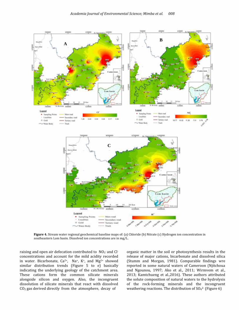
2- and accounted for 9.8% of the total variance. This single variable correlated with the presence of sulphide bearing minerals and gold deposits. Gold occurs as quartz veins associated with vug-filling early pyritization in the Lom Basin (Omang et al., 2014). Regional spatial distribution and sources of enriched geochemistry Figures 4, 5 and 6 showed the regional geochemical maps for dissolved ions. Concentrations of NO3
- and Cl- (Figure
4a and b) corresponded to high levels of H+ or low pH (Figure 4c) in the northeastern portion of the study area. Such similar distribution pattern is observed in localities close to the volatile border between Cameroon and the Central African Republic. These localities host more than two hundred thousand refugees. Hence, the domestic waste water produced from these municipalities, stock-
Academia Journal of Environmental Science; Mimba et al. 008
B A
C
Figure 4. Stream water regional geochemical baseline maps of: (a) Chloride (b) Nitrate (c) Hydrogen ion concentration in southeastern Lom basin. Dissolved ion concentrations are in mg/L.
raising and open air defecation contributed to NO3
- and Cl-
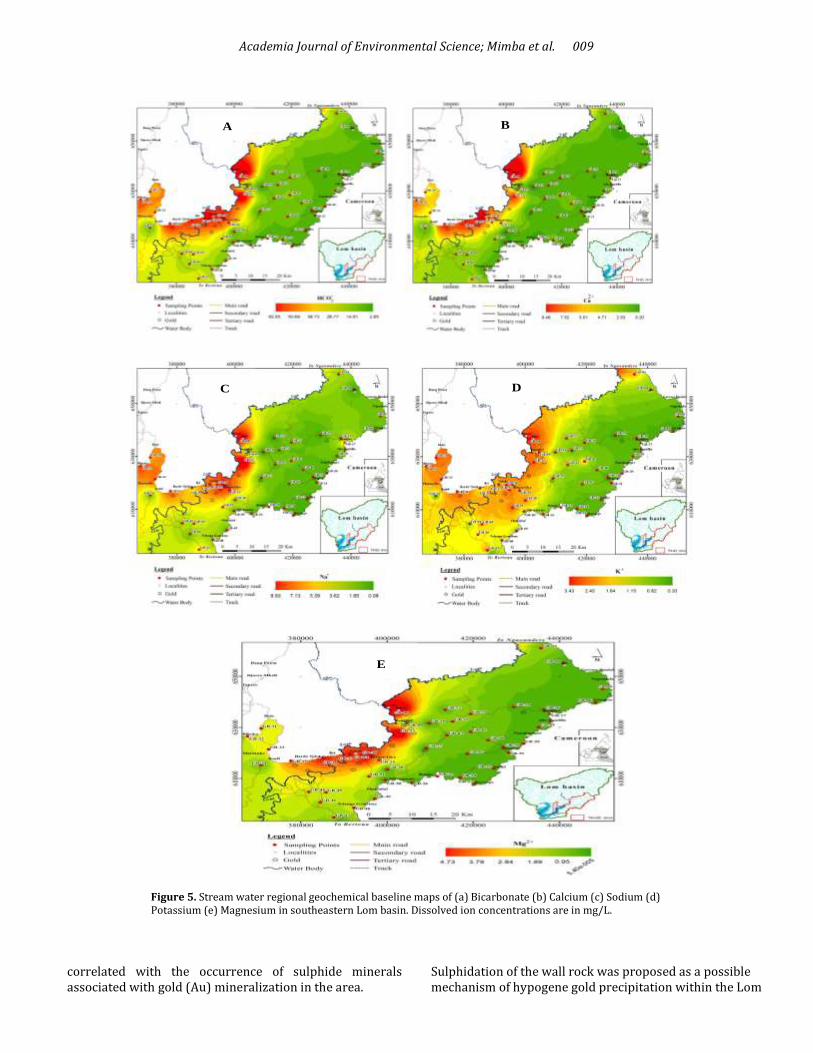
concentrations and account for the mild acidity recorded in water. Bicarbonate, Ca2+, Na+, K+, and Mg2+ showed similar distribution trends (Figure 5 to e) basically indicating the underlying geology of the catchment area. These cations form the common silicate minerals alongside silicon and oxygen. Also, the incongruent dissolution of silicate minerals that react with dissolved CO2 gas derived directly from the atmosphere, decay of
organic matter in the soil or photosynthesis results in the release of major cations, bicarbonate and dissolved silica (Stumm and Morgan, 1981). Comparable findings wre reported in some natural waters of Cameroon (Njitchoua and Ngounou, 1997; Ako et al., 2011; Wirmvem et al., 2013; Kamtchueng et al.,2016). These authors attributed the solute composition of natural waters to the hydrolysis of the rock-forming minerals and the incongruent weathering reactions. The distribution of SO4
2- (Figure 6)
Academia Journal of Environmental Science; Mimba et al. 009
A
D
B
C
E
Figure 5. Stream water regional geochemical baseline maps of (a) Bicarbonate (b) Calcium (c) Sodium (d) Potassium (e) Magnesium in southeastern Lom basin. Dissolved ion concentrations are in mg/L.
correlated with the occurrence of sulphide minerals associated with gold (Au) mineralization in the area.
Sulphidation of the wall rock was proposed as a possible mechanism of hypogene gold precipitation within the Lom

Academia Journal of Environmental Science; Mimba et al. 010
Figure 6. Stream water regional geochemical baseline map of Sulphate in southeastern Lom basin. Dissolved ion concentrations are in mg/L.
Group (Omang et al., 2015). Conclusions This study assessed the hydrochemistry of stream water in the Lom catchment. The stream water is mildly acidic to neutral in nature. Calcium and sodium were the dominant cations and bicarbonate dominated the anions. All the analyzed parameters except pH were within the desirable limits (WHO) for drinking purposes. CaHCO3 and NaHCO3 were the main water types in the area. In this research,
ionic relations among dissolved species were used to determine the roles of different geochemical processes affecting the chemistry of streams draining the Lom basin. Accordingly, the observed chemical composition of the stream water was mostly influenced by the chemical weathering of the surrounding rocks. Cation exchange and anthropogenic activities were minor geochemical controls.
The provenance of elements was distinguished based on geology and land use. Sodium, Ca2+, Mg2+ and K+ showed similar distribution trends reflecting the geology. Sulphate distribution was attributed to the presence of sulphide minerals associated with Au mineralization in the area.

Academia Journal of Environmental Science; Mimba et al. 011 The distribution pattern of NO3
- and Cl- reflected pollution
from settlements. These dissolved ions were considered to influence the acidity locally. The quality of surface water is easily influenced by anthropogenic activities and stream sediment collects effectively trace metals resulting from such activities. Therefore, geochemical mapping incorporating surface water and stream sediment is of considerable value in future investigations within the Lom basin. ACKNOWLEDGEMENTS This article forms part of Ph.D. research of MEM at Tokai University supported through the Japanese Government (MONBUKAGAKUSHO) Scholarship scheme under the Ministry of Education, Culture, Sports, Science and Technology (MEXT). Funding of the project by the Japan Science and Technology Agency (JST) is sincerely acknowledged. The authors are grateful for the provision of transportation facilities by the Institute of Geological and Mining Research (IRGM), Cameroon. Ivo Sumbele is appreciated for his diligent assistance during the field survey. REFERENCES Ahialey EK, Kortatsi BK, Anornu GK, Kaka EA, Dartey G (2015).
Hydrogeochemical processes influencing groundwater quality in the Black Volta Basin of Ghana. Res. J. Appl. Sc. Enginer. Technol. 11:975–982.
Ako AA, Shimada J, Hosono T, Ichiyanagi K, Nkeng GE, Fantong WY, Takem GEE, Njila NR (2011). Evaluation of groundwater quality and its suitability for drinking, domestic, and agricultural uses in the Banana Plain (Mbanga, Njombe, Penja) of the Cameroon Volcanic Line. Environ. Geochem. Health. 33:559–575.
Appelo CAJ, Postma D (1996). Geochemistry, groundwater and pollution. A.A. Balkema Publi. Leiden, (683).
Braun JJ, Viers J, Dupré B, Polve M, Ndam J, Muller JP (1998). Solid/Liquid REE Fractionation in the Lateritic System of Goyoum, East Cameroon: The Implication for the Present Dynamics of the Soil Covers of the Humid Tropical Regions. Geochim. Cosmochim. Acta. 62:273–299.
Butler JN (1981). Carbon Dioxide Equilibria. Lewis Publishers, Chelsea, Michigan.116–118.
Edjah AKM, Akiti TT, Osae S (2015). Hydrogeochemistry and isotope hydrology of surface water and groundwater systems in the Ellembelle district, Ghana, West Africa. Appl. Water Sci.13201(015):0273-3.
Fisher RS, Mullican FW (1997). Hydrochemical evolution of sodium-sulphate and sodium-chloride groundwater beneath the Northern Chihuahuan Desert. Hydrogeol. J. 5: 14–16.
Freeze RA, Cherry JA (1979). Groundwater. Prentice-Hall, Englewood Cliffs. 604.
Freyssinet PH, Lecompte P, Edimo A (1989). Dispersion of gold base metals in the Mborguene lateritic profile, East Cameroon. J. Geochem. Explor. 32:99–116.
Gray DJ, Noble RRP, Reid N, Sutton GJ, Pirlo MC (2016). Regional scale hydrogeochemical mapping of the northern Yilgarn Craton, Western Australia: a new technology for exploration in arid Australia. Geochem: Explor. Environ. Analy. 16:100–115.
Hounslow AW (1995). Water quality data: analysis and interpretation. CRC Lewis Publisher, New York. 396.
Howarth RJ, Thornton I (1983). Regional geochemical mapping and its application to environmental studies. Appl. Environ. Geochem (Thornton, I., ed.), 14–73, Academic Press.
Ibe KK, Akaolisa CZ (2010). Hydrogeochemical data as a tool for exploration and mapping: a case study from part of Afikpo Basin southeastern Nigeria. Environ. Monit. Assess. 160:393–400.
Johnson CC, Breward N, Ander EL, Ault L (2005). Baseline geochemical mapping of Great Britain and Northern Ireland. Geochem: Explor. Environ. Analy. 5:347–357.
Jorquera CO, Oates CJ, Plant JA, Kyser K, Ihenfield C, Vouvoulis N (2015). Regional hydrogeochemical mapping in Central Chile: natural and anthropogenic sources of elements and compounds. Geochem: Explor. Environ. Analy. 15:72–96.
Kamtchueng BT, Fantong WY, Wirmvem MJ, Tiodjio RE, Takounjou AF, Ndam Ngoupayou JR, Kusakabe M, Zhang J, Ohba T, Tanyileke G, Hell JV, Ueda A (2016). Hydrogeochemistry and quality of surface water and groundwater in the vicinity of Lake Monoun, West Cameroon: approach from multivariate statistical analysis and stable isotopic characterization. Environ. Monit. Assess. 188-524.
Kankeu B, Greiling RO, Nzenti JP, Bassahak J, Hell JV (2012). Strain partitioning along the Neoproterozoic Central African Shear Zone system: structures and magnetic fabrics (AMS) from the Meiganga area, Cameroon. N. Jb. Geol. Paläont. Abh. 265:27–47.
Kelepertzis E, Argyraki A, Daftsis E (2012). Geochemical signature of surface and stream sediments of a mineralized drainage basin at NE Chalkidiki Greece: A pre-mining survey. J. Geochem. Explor. 114:70–81.
Kim K, (2003). Long-term disturbance of ground water chemistry following well installation. Groundwater. 41:780–789.
Kim K, Rajmohan N, Kim HJ, Kim SH, Hwang GS, Yun ST, Gu B, Cho MJ, Lee SH (2005). Evaluation of geochemical processes affecting groundwater chemistry based on mass balance approach: A case study in Namwon, Korea. Geochem. J. 39:357–369.
Kusimi JM, Kusimi BA (2012). The hydrochemistry of water resources in selected mining communities in Tarkwa. J. Geochem. Explor. 112:252–261.
Lapworth DJ, Knights KV, Key RM, Johnson CC, Ayoade E (2012). Geochemical mapping using stream sediments in west-central Nigeria: Implications for environmental studies and mineral exploration in West Africa. Appl. Geochem. 27:1035–1052.
Ngako V, Affaton P, Nnange JM, Njanko TH (2003). Pan-African tectonic evolution in central and southern Cameroon: transpression and transtension during sinistral shear movements. J. African Earth Sciences. 36:207–221.
Njitchoua R, Ngounou NB (1997). Hydrogeochemistry and environmental isotope investigations of the North Diamare plain, Northern Cameroon. J. Afri. Earth Sci. 25:307–316.
Omang BO, Bih CV, Fon NN, Suh CE (2014). Regional geochemical stream sediment survey for gold exploration in the upper Lom basin, eastern Cameroon. Int. J. Geosci. 5:1012–1026.
Omang BO, Suh CE, Lehmann B, Vishiti A, Chombong NN, Fon A, Egbe JA, Shemang EM (2015). Microchemical signature of alluvial gold from two contrasting terrains in Cameroon. J. Afri. Earth Sci. 112:1–14.
Ouyang Y, Nkedi-Kizza P, Wu QT, Shinde D, Huang CH (2006). Assessment of seasonal variations in surface water quality. Water Res. 40:3800–3810.
Piper AM (1944). A graphical procedure in the geochemical interpretation of water analysis. Transactions, American Geophy. Union. 25:914–928.
Plant JA, Smith D, Smith B, Williams L (2001). Environmental geochemistry at global scale. Appl. Geochem. 16:1291–1308.
Reimann C, Garrett RG (2005). Geochemical background—concept and reality. Sci. Total Environ. 350:12–27.
Rose (2002). Comparative major ion geochemistry of piedmont streams in the Atlanta, Georgia region: possible effects of urbanization. Environ. Geol. 42:102–113.
Salminen R, Gregorauskiene V (2000). Considerations regarding the definition of a geochemical baseline of elements in the surficial materials in areas differing in basic geology. Appl. Geochem. 15:647–653.
Salminen R, Tarvainen T, Demetriades A, Duris M, Fordyce FM, Gregorauskiene V, Kahelin H, Kivisilla J, Klaver G, Klein H, Larson J O,

Academia Journal of Environmental Science; Mimba et al. 012 Lis J, Locutura J, Marsina K, Mjartanova H, Mouvet C, O’Connor P, Odor L,
Ottonello G, Paukola T, Plant JA, Reimann C, Schermann O, Siewers U,Steenfelt A, Van der Sluys J, deV ivo B, Williams L (1998). FOREGS Geochemical mapping field manual. Geol. Surv. Finland Guide 47:16–21.
Singh AK, Mondal GC, Singh PK, Singh TB, Tewary BK (2005). Hydrochemistry of reservoirs of Damodar River basin, India: weathering processes and water quality assessment. Environ. Geol. 8:1014–1028.
Soba D, Michard A, Toteu SF, Norman DI, Penaye J, Ngako V, Nzenti JP, Dautel D (1991). Donnes geochronologiques nouvelles (Rb-Sr, U-Pb et Sm-Nd) sur la zone mobile pan-africaine de l'Est Cameroun: age Proterozoïque superieur de la série du Lom, Comptes Rendus l'Academie Sci.. 312:1453–1458.
Stumm W, Morgan JJ (1981). Aquatic Chemistry, An Introduction Emphasising Chemical Equilibria in Natural Waters 2nd edition. John Wiley & Sons, Inc, New York.526–538.
Suh CE, Lehmann B (2003). Morphology and electron-probe microanalysis of residual gold-grain at Dimako, south east Cameroon. N. Jb. Mineral. Mh. 6:255–275.
Suh CE, Lehmann B, Mafany GT (2006). Geology and geochemical aspects of lode gold mineralization at Dimako- Mboscorro SE Cameroon. Geochem: Explor. Environ. Analy. 6:295–309.
Tamez-Mélendez C, Hernandez-Antonio A, Gaona-Zanella PC, Ornelas-Soto N, Mahlknecht J (2016). Isotope signatures and hydrochemistry as tools in assessing groundwater occurrence and dynamics in a coastal arid aquifer. Environ. Earth Sci. 12665-016-5617-2.
Tiwari AK, Singh AK (2014). Hydrogeochemical investigation and groundwater quality assessment of the Pratapgarh District, Uttar Pradesh. Geol. Soc. India. 83:329–343.
Toteu SF, Penaye J, Deloule E, Van Schmus WR, Tchamen IR (2006). Diachronous evolution of volcano-sedimentary basins north of the Congo craton: insights from U–Pb ion microprobe dating of zircons from the Poli, Lom and Yaounde Series (Cameroon). J.Afri. Earth Sci. 44:428–442.
Toteu SF, Penaye J, Poudjom DY (2004). Geodynamic evolution of the Pan-African belt in Central Africa with special reference to Cameroon. Canadian J. Earth Sci. 41:73–85.
Toteu SF, Van Schmus RW, Penaye J, Michard A (2001). New U-P b and Sm-Nd data from north central Cameroon and its bearing on the pre-pan-African history of Central Africa. Precam. Res. 108:45–73.
WHO (2011). Guidelines for Drinking-Water Quality, Fourth Edition,
Geneva, 564. Wirmvem MJ, Ohba T, Fantong WY, Ayonghe SN, Suila JY, Asaah ANE,
Tanyileke G, Hell JV (2013). Hydrogeochemistry of shallow groundwater and surface water in the Ndop plain, North West Cameroon. Afri. J. Environ. Sci. Technol. 7(6):518–530.
Cite this article as: Mimba ME, Ohba T, Fils NSC, Wirmvem MJ, Bate TEE, Nforba MT, Aka FT (2017). Regional Hydrogeochemical Mapping in the Mineralized Lom Basin, East Cameroon: A Pre-industrial Mining Survey. Acad. J. Environ. Sci. 5(1): 001-012. Submit your manuscript at http://www.academiapublishing.org/journals/ajes