Embed Size (px)
Citation preview

SAFFG - 11 June 2007 1
Regional Flash Flood GuidanceRegional Flash Flood Guidance
Konstantine Georgakakos, Director
Theresa Carpenter, Hydrologic Engineer
Jason Sperfslage, Software Engineer
Hydrologic Research Centerwww.hrc-lab.org

SAFFG - 11 June 2007 2
Flash FloodsFlash Floods
AMERICAN METEOROLOGICAL SOCIETY (AMS):
“ A flood that rises and falls quite rapidly with little or no advance warning,
usually as the result of intense rainfall over a relatively small area ”
WORLD METEOROLOGICAL ORGANIZATION (WMO):
“ A flood of short duration with a relatively high peak discharge ”
A local hydrometeorological phenomenon that requires:1. BOTH Hydrological and Meteorological expertise for real time forecasting/warning2. Knowledge of local up to the hour information for effective warning (24 - 7 operation)
For this effort: response time is 6 hours or less

SAFFG - 11 June 2007 3
Large River Flooding vs. Flash FloodingLarge River Flooding vs. Flash FloodingLarge River Flooding vs. Flash FloodingLRV
Catchment response affords long lead times
Entire hydrographs can be produced w/ low uncertainty with good quality data
Local information less valuable
A hydrologic forecasting problem primarily
Affords time for coordination of flood response and damage mitigation
FF
Catchment response is very fast and allows very short lead times (< 12hrs)
Prediction of occurrence is of interest
Local information is very valuable
A truly hydro-meteorological forecasting problem
Coordination of forecasting and responseis challenging over short times

SAFFG - 11 June 2007 4
No flash flood warnings for vast populated areas of the worldLack of local expertise and of regional cooperationLittle in situ data in small regionsLarge-river flood-warning strategies ineffective for flash floods
The NeedThe Need
Flash Floods are very significant disasters globally …
… BUT there are no discernible trends for loss reduction
Highest number of deaths per people affected
SAFFG - 11 June 2007 5
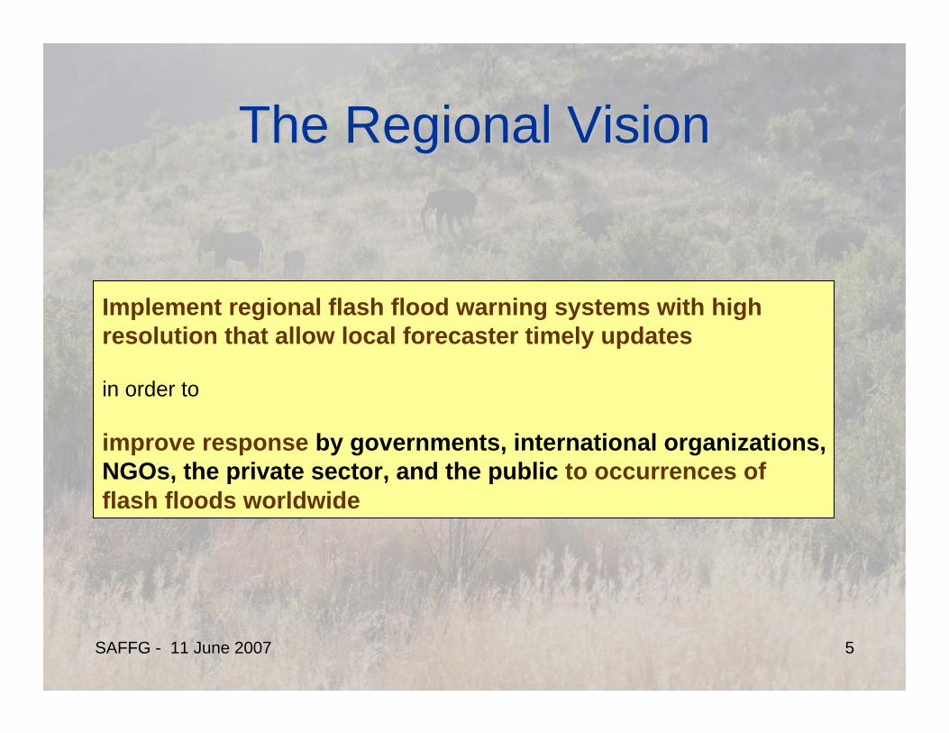
The Regional VisionThe Regional Vision
Implement regional flash flood warning systems with high resolution that allow local forecaster timely updates
in order to
improve response by governments, international organizations, NGOs, the private sector, and the public to occurrences of flash floods worldwide

SAFFG - 11 June 2007 6
National PerspectiveNational Perspective
System with national and regional components
National Level: Real-time national retrieval and operations maintenancePowerful computing environmentMeteorological and Hydrological expertiseCommunications
Regional Level: Meteorological and Hydrological expertiseCommunicationsLocal information and processingForecasting and warningLink to response agencies

SAFFG - 11 June 2007 7
Flash Flood GuidanceFlash Flood GuidanceFlash Flood Guidance (in/hr) Gridded Rainfall (in/hr) Excess Flooding (in/hr)
Flash Flood Guidance (FFG): The amount of rainfall of a given duration required to generate bankfull flows at the outlet of a basin.
Hydrology Meteorology Hydrometeorology

SAFFG - 11 June 2007 8
DHM vs. FFGDHM vs. FFGDHM vs. FFGDHM
Tool for short and longterm forecasting of floods
Produces entire hydrographs (w/ high uncertainty on small scales)
Difficult to ingest local precipitation information after model cycle
Awkward for local forecasters to make adjustments, needed for reliable flash flood warning
Expensive to run in real time for very large areas with high resolution
FFGDiagnostic tool useful for quick flash floodoccurrence diagnosis and short term prediction
Concerns bankfull flows
Readily ingests local precipitation information
Local forecaster adjustments easy
Promotes Close Collaboration of Hydrologists with Meteorologists

SAFFG - 11 June 2007 9
Attributes of FFGAttributes of FFGAttributes of FFG
Diagnostic tool useful for quick flash flood occurrence potential diagnosis in real time to alert local forecasters of an impending danger
Concerns bankfull flows
Readily ingests local precipitation information
Local forecaster adjustments easy
Promotes Close Collaboration of Hydrologists with Meteorologists

SAFFG - 11 June 2007 10
From National Data to Regional Hydrometeorology From National Data to Regional Hydrometeorology to Local Data and Warningsto Local Data and Warnings
ComputationalComponent
National/Regional Observations & ATM Model Forecasts
Local Products& Uncertainty
Local or Regional Warning Generation System
Local Data
Local or Regional Warning Dissemination System
Response Agencies
1. Decisions are made with multiple datasets and under uncertainty2. There is a need to modify the products of the national system regionally and have capability for estimating consequences to local variables of interest
Computational Core
Adjustments and WarningCore

SAFFG - 11 June 2007 11
Regional Component for WarningsRegional Component for WarningsNational Dissemination
System
GIS Analysis Tools
Database
Forecaster
RegionalDissemination
System / Response
Regional/LocalData
Regional Network
National Network

SAFFG - 11 June 2007 12
Dealing with Forecast Uncertainty is Dealing with Forecast Uncertainty is ImportantImportant
Forecasts are inherently uncertain
Decisions to issue warnings and take responsemeasures are made under uncertainty
Hydrometeorological forecasts for smaller regions based on national data carry considerable uncertainty
Uncertainty comes in a variety of forms, from biases toa variety of distributions of forecast residuals, and it is time dependent. So it must be considered by the system in a non-trivial quantitative manner.

SAFFG - 11 June 2007 13
Research and Development HistoryResearch and Development History• 1970-1988: US NWS Produces FFG statistically for each River Forecast
Center. Also, research in adaptive site specific FF prediction systems.• 1988-1993: IIHR/HRC develop physically consistent FFG formulations
based on GIS and create the first operational codes for US NWS• 1993-2005: HRC continues research in various aspects of the FFG process
and system (sparsely gauged basins and uncertainty issues, forcing and models). The development of prototype regional systems using FFG are proposed and accepted in work plan of WMO CHy Working Group on Applications (2002-2003)
• 2004: The Central America Flash Flood Guidance System becomes operational (serves 7 countries in CA)
• 2006: Additional systems are under development or considered for deployment in Korea, Romania and Southeast Asia
Key In-depth References (out of a total of 41 reports and papers):
Carpenter, T.M., et al. (1999) Journal of Hydrology 224, 21-44. – Threshold RunoffGeorgakakos, K.P. (2005) Journal of Hydrology 317, 81-103. – Soil Moisture/FFG Ntelekos, A.A., et al. (2006), J. Hydrometeorology, 7(5), 896-915. – Uncertainty in FFGGeorgakakos, K.P. (2005/2007) ACTIF Norway 05 Conf. Proc. & Journal of Hydrometeorology (in review)Sperfslage, J.A., et al. (2004) HRC Limited Distribution Report – Operational System Implementation

SAFFG - 11 June 2007 14
Regional Warning SystemRegional Warning System

SAFFG - 11 June 2007 15
Central America Flash Flood GuidanceCentral America Flash Flood Guidance
SAFFG - 11 June 2007 16
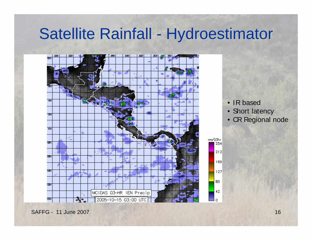
Satellite Rainfall Satellite Rainfall -- HydroestimatorHydroestimator
•• IR basedIR based•• Short latencyShort latency•• CR Regional nodeCR Regional node

SAFFG - 11 June 2007 17
Satellite Rainfall Adjustment and MergingSatellite Rainfall Adjustment and MergingVastly different scales of satellite pixel and rain gauge areaOrography organizes surface rainfall according to prevailing windsSatellite IR returns do not directly measure rainfall There may be significant misregistration errors in satellite data
0 ,0
1 ( , )
( , )
SATL K
G o o
R f x y dxdyKL
R f x y− −
=
=
∫∫
x
y
0
L
0K
Raingauge
Sat Pixel
f(x,y): Rainfall volume field over a time interval T
0, ; ( ) ( )SAT G SAT GR R R g R g R Bα ε≥ = + +
(xo,yo)
Regional Bias
Random ErrorTransformationfor Normality

SAFFG - 11 June 2007 18
Bias Adjustment BasicsBias Adjustment Basics
1 1t t twβ β+ += +
1 1 1t t tz vβ+ + += +
1
1
( , )
( , )
g
g
N
gj
t N
sj
R t jn
R t jβ =
=
⎡ ⎤⎢ ⎥⎢ ⎥=⎢ ⎥⎢ ⎥⎣ ⎦
∑
∑
Kalman Filter Stochastic Approximations
• N pairs of consecutive values• At least 20% raingauges with rain• Conditional Mean > Threshold (mm/h)
(satellite and gauge)
Bias (B)Bias (B)

SAFFG - 11 June 2007 19
Kalman Filter for Tracking the Kalman Filter for Tracking the ErrorsErrors
1ˆ ˆ
t tβ β− ++ =
1 1t t tP P Q− ++ += +
( )1 1 1 1 1ˆ ˆ ˆ
t t t t tK zβ β β+ − −+ + + + += + −
1 1 1(1 )t t tP K P+ −+ + += −
11 1 1 1( )t t t tK P P R− − −
+ + + += +
Prediction:
Updating:
Stochastic ApproximationsAlgorithm

SAFFG - 11 June 2007 20
Stochastic Approximations Stochastic Approximations Algorithm for Model Error VarianceAlgorithm for Model Error Variance
( )1
21 1 1 12
211
ˆ ˆ ( )
tt
t t t t t
tt t
P SQ
Q Q r P RP SQ
σ
−+
− −+ + + +−
++
⎛ ⎞∂⋅⎜ ⎟∂⎝ ⎠= + ⋅ − −
⎛ ⎞∂+⎜ ⎟∂⎝ ⎠
Enforces compliance between predicted residual variance and Enforces compliance between predicted residual variance and theoretical residual variancetheoretical residual variance
12
1
1 21
1t
tt t
PQ
SSσ
−−+
++
⎡ ⎤⎛ ⎞∂⎢ ⎥⎜ ⎟∂⎢ ⎥⎝ ⎠= +⎢ ⎥⎢ ⎥⎢ ⎥⎣ ⎦
( )221 1 12t t tP Rσ −
+ + += +
Applied each time stepApplied each time step

SAFFG - 11 June 2007 21
Bias Adjustment Algorithm Bias Adjustment Algorithm ApplicationApplication
2
1ˆ o
o o
PQP R
=+
( )2
1 1ˆ0.9S Q=
1 1PQ
−∂=
∂
Initial ConditionsInitial Conditions
Restarts due to gauge data Restarts due to gauge data errorserrors
•• Once a day for the past 24 hrsOnce a day for the past 24 hrs•• Bias estimated from at least 25 pairsBias estimated from at least 25 pairs•• Gauges and satellite grids included ifGauges and satellite grids included if
rainfall greater than 1 mm/hrainfall greater than 1 mm/h
Important issue:Important issue:Gauge data quality controlGauge data quality control

SAFFG - 11 June 2007 22
Synthetic Data TestsSynthetic Data Tests
Medium Observation Error Large Observation Error

SAFFG - 11 June 2007 23
Costa Rica Data TestsCosta Rica Data Tests
<β> = 0.5
<B> = e0.5 = 1.65
{ }1 1 1ˆˆ exp 0.5t t tB Pβ− − −
+ + += +
( ) { }( )2
1 11ˆ exp 1t ttB P− − −
+ ++= −∑2x2x

SAFFG - 11 June 2007 24
CAFFG Operational ResultsCAFFG Operational Results

SAFFG - 11 June 2007 25
3-hr Flash Flood Guidance Probability Density Function
0 50 100 150 200 250 3000
0.002
0.004
0.006
0.008
0.01
0.012
0.014
0.016
0.018
0.02
3-hrs Actual Rainfall Volume (mm)
Lognormal
0 50 100 150 200 250 3000
0.002
0.004
0.006
0.008
0.01
0.012
0.014
0.016
0.018
0.02
3-hrs Actual Rainfall Volume (mm)
Lognormal
+ User input
Uncertainty EstimationUncertainty EstimationDry Soils Wet Soils

SAFFG - 11 June 2007 26
CAFFG NMHS PRODUCTSCAFFG NMHS PRODUCTS
SAFFG - 11 June 2007 27
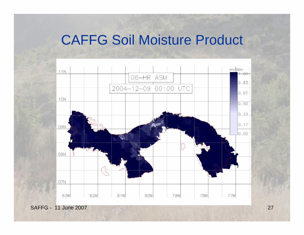
CAFFG Soil Moisture ProductCAFFG Soil Moisture Product

SAFFG - 11 June 2007 28
6-HOUR SOIL SATURATION RATIO0 - 0.330.33 - 0.50.5 - 0.640.64 - 0.770.77 - 0.880.88 - 1
N
EW
S
Central America Flash Flood Guidance System6-Hourly Soil Moisture - Date: 15 May 2004 0000Z
CAFFG Regional Soil Moisture ProductCAFFG Regional Soil Moisture Product

SAFFG - 11 June 2007 29
Training and CooperationTraining and Cooperation
Training:
System Technical BasisMaintenanceInterpretation of Guidance Products
Hands-on training of personnel who will operate the systemWorkshops for NMHS and Response Agency personnel
Cooperation:
Assist NHMSs to develop protocol for issuing warnings based on flash flood guidance
Assist NMHSs and Response Agencies to develop protocol for dissemination, receipt and interpretationof warning information to appropriate users within countries
Assist NMHSs and Response Agencies to develop evaluation plans for system utility

SAFFG - 11 June 2007 30
CAFFG Initial ValidationCAFFG Initial ValidationSystem operators from Costa Rica and El Salvador were in daily communication with Country Agencies to receive community information regarding local flooding
3-Hourly FF Threat (adjst):Hits: 57% (63 – 100%)False: 30% (0 - 21%)Misses: 13% (0 - 16%)
Clasificación de cuencasNo hay datoInundación o inundación inminentePosible inundaciónNo hay riesgo de inundación
100 0 100 200 Kilometers
N
EW
S
Evaluación del riesgo de inundación correspondiente al 17-09-04 a las 18 Z válido a las 00 Z del 18-09-04
Flooding in the Panama Canal verified by local TV news. Flooding time at the airport was reported at approximately 9 p.m. local time.

SAFFG - 11 June 2007 31
Disaster Risk Reduction ComponentDisaster Risk Reduction Component
Aim:Effective utilization of flash flood warnings for protection of lives, livelihoodsand property.
Objective:Ensure effective integration of the flash flood guidance information in disaster risk reduction
Means:Strengthen cooperation among the technical and civil protection agenciesDevelop joint training programsDevelop validation programs and informationAssist in developing public outreach and awareness programs (regional to local)

SAFFG - 11 June 2007 32
CAFFG Funding AgenciesCAFFG Funding Agencies
U. S. Agency for International Development (USAID)- Office of U. S. Foreign Disaster Assistance (OFDA)
U. S. National Oceanic and Atmospheric Administration (NOAA)- Office of Hydrologic Development/ National Weather Service- International Activities Office/ National Weather Service- Climate Program Office
SAFFG - 11 June 2007 33
Thank YouThank You