Embed Size (px)
Citation preview
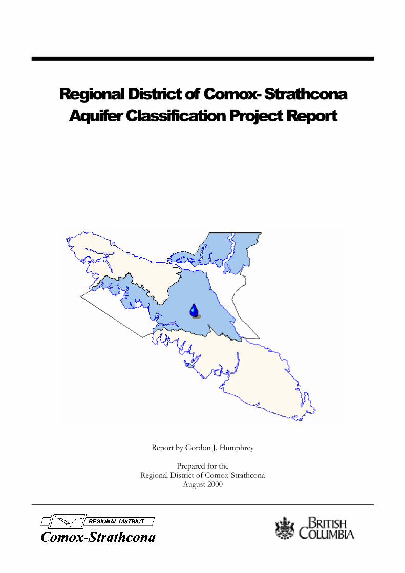
Regional District of Comox- Strathcona Aquifer Classification Project Report
Report by Gordon J. Humphrey
Prepared for the Regional District of Comox-Strathcona
August 2000
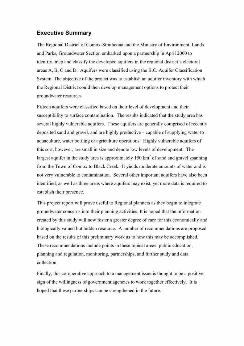
Executive Summary
The Regional District of Comox-Strathcona and the Ministry of Environment, Lands
and Parks, Groundwater Section embarked upon a partnership in April 2000 to
identify, map and classify the developed aquifers in the regional district’s electoral
areas A, B, C and D. Aquifers were classified using the B.C. Aquifer Classification
System. The objective of the project was to establish an aquifer inventory with which
the Regional District could then develop management options to protect their
groundwater resources
Fifteen aquifers were classified based on their level of development and their
susceptibility to surface contamination. The results indicated that the study area has
several highly vulnerable aquifers. These aquifers are generally comprised of recently
deposited sand and gravel, and are highly productive – capable of supplying water to
aquaculture, water bottling or agriculture operations. Highly vulnerable aquifers of
this sort, however, are small in size and denote low levels of development. The
largest aquifer in the study area is approximately 150 km2 of sand and gravel spanning
from the Town of Comox to Black Creek. It yields moderate amounts of water and is
not very vulnerable to contamination. Several other important aquifers have also been
identified, as well as three areas where aquifers may exist, yet more data is required to
establish their presence.
This project report will prove useful to Regional planners as they begin to integrate
groundwater concerns into their planning activities. It is hoped that the information
created by this study will now foster a greater degree of care for this economically and
biologically valued but hidden resource. A number of recommendations are proposed
based on the results of this preliminary work as to how this may be accomplished.
These recommendations include points in these topical areas: public education,
planning and regulation, monitoring, partnerships, and further study and data
collection.
Finally, this co-operative approach to a management issue is thought to be a positive
sign of the willingness of government agencies to work together effectively. It is
hoped that these partnerships can be strengthened in the future.
Acknowledgements
The author wishes to thank several key groups and individuals that provided
information and expertise throughout the course of this project. Foremost, Mike Wei,
Bill Hodge and Kevin Ronneseth of the Ministry of Environment, Lands and Parks,
Groundwater Section offered a great deal of support and assistance. Red Williams
Water Well Drilling Limited and Anderson Water Wells also co-operated in sharing
their first-hand accounts of groundwater occurrences in the study area. The staff of
the Ministry of Transportation and Highways (particularly Don Lister, Bryan Kerns,
and Jerry Leet) were especially helpful in contributing information gathered through
the activities of that Ministry. Alison Mewett and the Regional District of Comox-
Strathcona played a key role in ensuring that this project was given the priority it
demanded and also provided funding. And finally, a personal thank you goes to Ryan
Melsom for his assistance. Only through the diligence and co-operation of the
aforementioned parties were this project’s goals attainable.
Table of Contents 1.0 INTRODUCTION ......................................................................................................................1
1.1 PROJECT OBJECTIVES ................................................................................................................2 1.2 DEFINING THE STUDY AREA......................................................................................................2 1.3 DESCRIPTION OF THE STUDY AREA ...........................................................................................3
2.0 THE B.C. AQUIFER CLASSIFICATION SYSTEM .............................................................5 2.1 THE CLASSIFICATION SYSTEM ..................................................................................................5 2.2 THE RANKING COMPONENT ......................................................................................................6 2.3 DELINEATING AQUIFER BOUNDARIES .......................................................................................8 2.4 RELATIONSHIP BETWEEN AQUIFER CLASS AND RANKING VALUE.............................................8 2.5 INTERPRETING AQUIFER MAPPING ............................................................................................8 2.6 USES OF THE B.C. AQUIFER CLASSIFICATION SYSTEM..............................................................9
3.0 SURFICIAL GEOLOGY OF THE STUDY AREA ..............................................................10 3.1 SALISH SEDIMENTS .................................................................................................................11 3.2 CAPILANO SEDIMENTS ............................................................................................................12 3.3 MARINE/ GLACIO-MARINE VENEER........................................................................................13 3.4 VASHON TILL ..........................................................................................................................14 3.5 QUADRA SEDIMENTS...............................................................................................................14 3.6 PRE-QUADRA SEDIMENTS .......................................................................................................15 3.7 NANAIMO GROUP (BEDROCK).................................................................................................15
4.0 AQUIFERS OF THE COMOX-STRATHCONA REGIONAL DISTRICT.......................16 4.1 AQUIFER 407: POINT HOLMES.................................................................................................17 4.2 AQUIFER 408: COMOX-MERVILLE...........................................................................................18 4.3 AQUIFER 409: LITTLE RIVER...................................................................................................19 4.4 AQUIFER 410: SOUTH OYSTER RIVER .....................................................................................19 4.5 AQUIFER 411: BLACK CREEK ..................................................................................................20 4.6 AQUIFER 412: NORTH OYSTER RIVER.....................................................................................21 4.7 AQUIFER 413: ROYSTON .........................................................................................................21 4.8 AQUIFER 414: ROSEWALL CREEK ...........................................................................................22 4.9 AQUIFER 415: BASE FLATS .....................................................................................................23 4.10 AQUIFER 416: BOWSER ...........................................................................................................23 4.11 AQUIFER 417: PUNTLEDGE .....................................................................................................24 4.12 AQUIFER 418: OYSTER RIVER .................................................................................................25 4.13 AQUIFER 419: WILFRED CREEK ..............................................................................................26 4.14 AQUIFER 420: ELMA BAY .......................................................................................................26 4.15 AQUIFER 421: NILE CREEK .....................................................................................................27
5.0 UNCLASSIFIED AREAS OF POTENTIAL AQUIFERS....................................................27 5.1 SHIPS POINT ............................................................................................................................28 5.2 ISLAND HIGHWAY COMMUNITIES ...........................................................................................28 5.3 MAPLE LAKE...........................................................................................................................29
6.0 AQUIFER DISCUSSION ........................................................................................................29
7.0 CONCLUSION .........................................................................................................................30
8.0 RECOMMENDATIONS .........................................................................................................31 8.1 PUBLIC EDUCATION ................................................................................................................32 8.2 PARTNERSHIPS ........................................................................................................................32 8.3 PLANNING AND REGULATION..................................................................................................33 8.4 MONITORING...........................................................................................................................34 8.5 FURTHER DATA COLLECTION AND STUDY ..............................................................................34
REFERENCES
GLOSSARY

List of Figures
FIGURE 1. THE REGIONAL DISTRICT OF COMOX-STRATHCONA AND STUDY AREA BOUNDARIES FIGURE 2. STRUCTURE OF B.C. AQUIFER CLASSIFICATION SYSTEM FIGURE 3. A STRATIGRAPHIC COLUMN REPRESENTING TYPICAL GEOLOGICAL ARRANGEMENT IN
THE STUDY AREA.
List of Tables
TABLE 1. AQUIFER CLASSIFICATION COMPONENT TABLE 2. AQUIFER RANKING COMPONENT TABLE 3. AQUIFER GEOLOGY AND CLASSIFICATION SUMMARY
List of Appendices
APPENDIX A: AQUIFER WORKSHEETS (AQUIFERS 407-421 INCLUSIVE) APPENDIX B: GEOLOGIC CROSS SECTIONS OF THE STUDY AREA APPENDIX C: AQUIFER CLASSIFICATION MAPSHEETS
Regional District of Comox- Strathcona August 2000 Aquifer Classification Mapping Project Report
1.0 Introduction
Due, in part, to the abundant supply of potable surface water, planners and resource
managers frequently overlook groundwater in British Columbia. However, 22% of
the province (over 750,000 people) relies on groundwater for their domestic water
needs (B.C. Environment, 1994). Moreover, 25% of municipal drinking water
supplies are taken from groundwater sources (excluding Vancouver and Victoria)
(B.C. Environment, 1994). Groundwater is also vital to several economic sectors,
particularly in areas where surface water quantity is low relative to demand. For
example, agricultural, industrial and fish hatchery operations within British Columbia
often depend entirely on large groundwater withdrawals, giving the resource
additional value.
With this reliance on groundwater, coupled with the anticipation of population and
economic growth, comes a need to incorporate the resource into planning activities.
British Columbia currently has no comprehensive legislation governing groundwater.
As a result, the Ministry of Environment, Lands and Parks (MELP) has relied on
innovative, non-regulatory approaches such as aquifer classification mapping in order
to protect this valuable resource. With this in mind, MELP has developed a process
for mapping and classifying aquifers based on their vulnerability to surface
contamination as well as their level of development. The information that has been
produced through this system has been made available to the public and private
sectors in order to facilitate better decision making. The system will be discussed at
length in the sections to follow.
The Regional District of Comox-Strathcona (RDCS) in conjunction with MELP
undertook to complete an inventory of the aquifers within the RDCS in April, 2000.
An agreement was reached by which MELP would supply the expertise and guidance
through its aquifer classification system, while the RDCS would fund the initiative
and take a lead role in liasing with stakeholders and securing relevant information.
This co-operative approach marks a significant step in groundwater stewardship in
British Columbia. It is believed that through further partnerships between
1
Regional District of Comox- Strathcona August 2000 Aquifer Classification Mapping Project Report
stakeholders, regulators and planners a more comprehensive approach to groundwater
management is closer at hand.
1.1 Project Objectives
The objectives of the B.C. Aquifer Classification System are fourfold. First, it seeks
to create a framework through which aquifers can be mapped and classified. Second,
it provides the tools to prioritize management, remediation and protection of aquifers.
Third, it is the vehicle through which a Provincial inventory of aquifers has been
constructed. Last, the aquifer classification system is an effective instrument for
increasing knowledge and understanding of the groundwater resource (Kreye et al.,
1996). These four objectives were at the forefront throughout this project.
The RDCS had similar strategic objectives at stake in initiating its partnership with
MELP. Foremost, planners have begun to acknowledge the need to incorporate
hydrogeologic considerations into their decision making processes. The B.C. Aquifer
Classification System promises to now provide the RDCS with the information
required to do so, while also providing the planning information necessary for more
effective land use.
The focus of this study is to establish an inventory, classify and create a better
understanding of the aquifers in the RSCS. It is not an objective of the study to
perform a detailed assessment of regional hydrogeology (i.e., direction of flow, site
specific vulnerability to contamination, location of recharge areas, water chemistry
analysis, etc.). Such activities may be the next steps to improving groundwater
management in the Regional District (see Recommendations), but this report seeks
only to create the initial framework that will later be used to make those decisions.
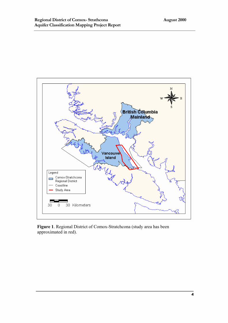
1.2 Defining the Study Area
The Regional District of Comox-Strathcona is located centrally on Vancouver Island,
British Columbia (Figure 1). The region is contained by Hart Creek (known locally
as Washer Creek) at its southeastern extent, trending laterally to the west coast of
Vancouver Island. The RDCS then spans the island north of Sayward. The Strait of
Georgia and the Pacific Ocean enclose the Regional District along its east and west
limits respectively, with notable exclaves on the British Columbia mainland as well as 2

Regional District of Comox- Strathcona August 2000 Aquifer Classification Mapping Project Report
several islands. The total area of the RDCS is approximately 20,000 square
kilometres.
The study area examined was reduced in size from the whole of the Regional District
(Figure 1). It largely includes the populated area of the Comox Valley, east of the
Beaufort Mountain range, and south of the District of Campbell River. In addition,
the study area was extended beyond the southern perimeter of the RDCS (i.e., to Nile
Creek) in order to gain a better understanding of the regional hydrogeology. It was
necessary to reduce the extent of the study area for two principle reasons. First, the
level of groundwater development in the RDCS west of the Beaufort Range and on
the mainland appears to be very low, or unreported. And second, MELP has not
undertaken any water well location mapping for these regions. Without this
information the location of groundwater wells is often uncertain.
1.3 Description of the Study Area
The study area is enclosed to the east by the Beaufort Mountains. This range is part
of the Insular Belt – the western most major divide associated with the tectonic
subdivision of the Canadian Cordillera (Muller, 1971). The Beaufort Mountains
overlook the Comox Valley to the east.
The Comox Valley is a part of the Georgia Depression, a formation that creates the
divide between the Coast Mountain Range and Vancouver Island. Evidence of the
valley’s glacial history mark the area. The topography is generally rolling, yet
hummocky in areas. A thick layer of unconsolidated deposits blanket much of the
region, particularly as distance east from the Beaufort Range increases. These
sediments provide a chronological history of Quaternary geomorphic events – they are
described in section four, Regional Geology.
The area is generally well drained surficially, having several large streams and rivers
(i.e., the Oyster, Puntledge, Courtenay and Tsolum Rivers), which for the most part
flow from glacial origins in the Beaufort Mountains. However, in areas north of the
Oyster River and in the Town of Comox, for example, little natural drainage exists.
These areas are typically marshy.
3
Regional District of Comox- Strathcona August 2000 Aquifer Classification Mapping Project Report
Figure 1. Regional District of Comox-Stratchcona (study area has been approximated in red).
4
Regional District of Comox- Strathcona August 2000 Aquifer Classification Mapping Project Report
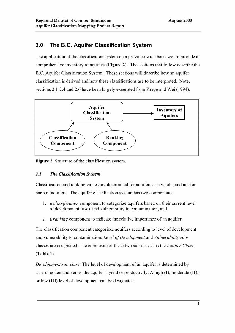
2.0 The B.C. Aquifer Classification System
The application of the classification system on a province-wide basis would provide a
comprehensive inventory of aquifers (Figure 2). The sections that follow describe the
B.C. Aquifer Classification System. These sections will describe how an aquifer
classification is derived and how these classifications are to be interpreted. Note,
sections 2.1-2.4 and 2.6 have been largely excerpted from Kreye and Wei (1994).
Classification Component
Ranking Component
Aquifer Classification
System
Inventory of Aquifers
Figure 2. Structure of the classification system.
2.1 The Classification System
Classification and ranking values are determined for aquifers as a whole, and not for
parts of aquifers. The aquifer classification system has two components:
1. a classification component to categorize aquifers based on their current level of development (use), and vulnerability to contamination, and
2. a ranking component to indicate the relative importance of an aquifer.
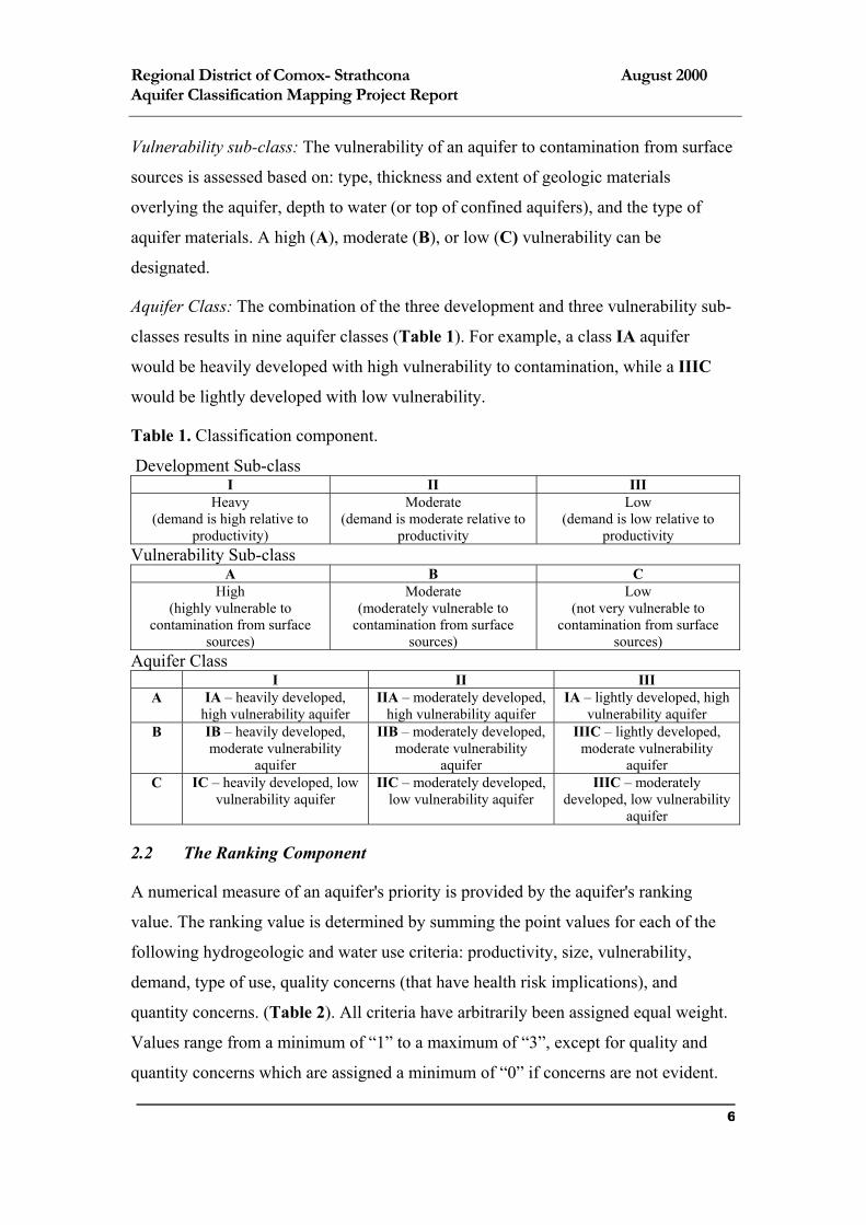
The classification component categorizes aquifers according to level of development
and vulnerability to contamination: Level of Development and Vulnerability sub-
classes are designated. The composite of these two sub-classes is the Aquifer Class
(Table 1).
Development sub-class: The level of development of an aquifer is determined by
assessing demand verses the aquifer’s yield or productivity. A high (I), moderate (II),
or low (III) level of development can be designated.
5
Regional District of Comox- Strathcona August 2000 Aquifer Classification Mapping Project Report
Vulnerability sub-class: The vulnerability of an aquifer to contamination from surface
sources is assessed based on: type, thickness and extent of geologic materials
overlying the aquifer, depth to water (or top of confined aquifers), and the type of
aquifer materials. A high (A), moderate (B), or low (C) vulnerability can be
designated.
Aquifer Class: The combination of the three development and three vulnerability sub-
classes results in nine aquifer classes (Table 1). For example, a class IA aquifer
would be heavily developed with high vulnerability to contamination, while a IIIC
would be lightly developed with low vulnerability.
Table 1. Classification component.
Development Sub-class I II III
Heavy (demand is high relative to
productivity)
Moderate (demand is moderate relative to
productivity
Low (demand is low relative to
productivity Vulnerability Sub-class
A B C High
(highly vulnerable to contamination from surface
sources)
Moderate (moderately vulnerable to
contamination from surface sources)
Low (not very vulnerable to
contamination from surface sources)
Aquifer Class I II III
A IA – heavily developed, high vulnerability aquifer
IIA – moderately developed, high vulnerability aquifer
IA – lightly developed, high vulnerability aquifer
B IB – heavily developed, moderate vulnerability
aquifer
IIB – moderately developed, moderate vulnerability
aquifer
IIIC – lightly developed, moderate vulnerability
aquifer C IC – heavily developed, low
vulnerability aquifer IIC – moderately developed,
low vulnerability aquifer IIIC – moderately
developed, low vulnerability aquifer
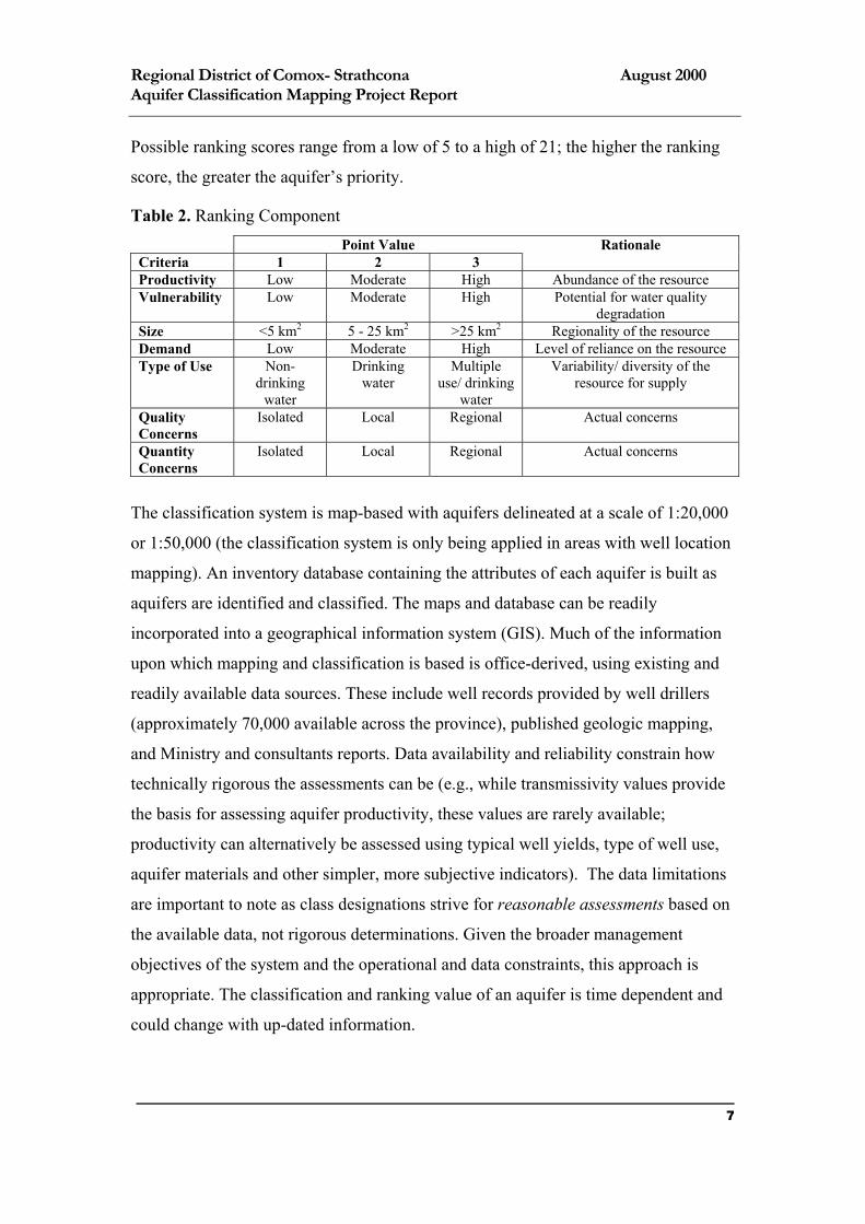
2.2 The Ranking Component
A numerical measure of an aquifer's priority is provided by the aquifer's ranking
value. The ranking value is determined by summing the point values for each of the
following hydrogeologic and water use criteria: productivity, size, vulnerability,
demand, type of use, quality concerns (that have health risk implications), and
quantity concerns. (Table 2). All criteria have arbitrarily been assigned equal weight.
Values range from a minimum of “1” to a maximum of “3”, except for quality and
quantity concerns which are assigned a minimum of “0” if concerns are not evident.
6
Regional District of Comox- Strathcona August 2000 Aquifer Classification Mapping Project Report
Possible ranking scores range from a low of 5 to a high of 21; the higher the ranking
score, the greater the aquifer’s priority.
Table 2. Ranking Component Point Value Rationale Criteria 1 2 3 Productivity Low Moderate High Abundance of the resource Vulnerability Low Moderate High Potential for water quality
degradation Size <5 km2 5 - 25 km2 >25 km2 Regionality of the resource Demand Low Moderate High Level of reliance on the resource Type of Use Non-
drinking water
Drinking water
Multiple use/ drinking
water
Variability/ diversity of the resource for supply
Quality Concerns
Isolated Local Regional Actual concerns
Quantity Concerns
Isolated Local Regional Actual concerns
The classification system is map-based with aquifers delineated at a scale of 1:20,000
or 1:50,000 (the classification system is only being applied in areas with well location
mapping). An inventory database containing the attributes of each aquifer is built as
aquifers are identified and classified. The maps and database can be readily
incorporated into a geographical information system (GIS). Much of the information
upon which mapping and classification is based is office-derived, using existing and
readily available data sources. These include well records provided by well drillers
(approximately 70,000 available across the province), published geologic mapping,
and Ministry and consultants reports. Data availability and reliability constrain how
technically rigorous the assessments can be (e.g., while transmissivity values provide
the basis for assessing aquifer productivity, these values are rarely available;
productivity can alternatively be assessed using typical well yields, type of well use,
aquifer materials and other simpler, more subjective indicators). The data limitations
are important to note as class designations strive for reasonable assessments based on
the available data, not rigorous determinations. Given the broader management
objectives of the system and the operational and data constraints, this approach is
appropriate. The classification and ranking value of an aquifer is time dependent and
could change with up-dated information.
7
Regional District of Comox- Strathcona August 2000 Aquifer Classification Mapping Project Report
2.3 Delineating Aquifer Boundaries
One of the primary tasks of classification is identification of an aquifer and
delineation of its boundaries. As classification is based on existing information,
aquifer boundaries range from reasonable assessments (where detailed information is
available) to general approximations (scarce information availability). Only those
aquifers which have sufficient groundwater development are delineated and classified.
In cases where aquifers cannot be fully delineated, especially confined,
unconsolidated aquifers and bedrock aquifers, boundaries are defined by the area of
groundwater development. Aquifers with areas less than one square kilometre are
generally not mapped. Guidelines for determining level of development, vulnerability
to contamination and ranking values are detailed in Kreye and Wei (1994).
2.4 Relationship between Aquifer Class and Ranking Value
Aquifer class and ranking values are related in that, together, they provide both
descriptive and quantitative information about the priority of an aquifer for
management and protection. Classification of over 400 aquifers province-wide to-date
shows that ranking values generally increase with increasing levels of development
and increasing vulnerability. This occurs because factors considered in the
classification component (demand, productivity and vulnerability) also appear in the
ranking component.
2.5 Interpreting Aquifer Mapping
The Groundwater Section is soon to release a Guidance Document for aquifer
classification mapping. Although the document is very near completion it was not
available at the time of this study. In lieu of it, the following section is intended to
provide insight into how to interpret the aquifer classification mapping completed for
this project.
As discussed, aquifer classification mapping illustrates the presence of aquifers. It
should also be mentioned that on occasions where insufficient data exists, dashed
lines appear on the mapping in order to indicate a lower level of confidence in the
delineation results. Data reliability can be a concern in areas where well records have
not been submitted to MELP, they are incomplete, the wells could not be located or
8
Regional District of Comox- Strathcona August 2000 Aquifer Classification Mapping Project Report
where very few wells exist in a geologic formation. These areas may, however, be
revisited when additional data are available.
Several other important symbols may also appear on aquifer classification mapping.
These features include:
high capacity wells (those with yields greater than 3.0 litres per second (L/s)),
•
•
•
•
•
flowing wells (flowing artesian wells),
high capacity flowing wells (flowing artesian wells yielding greater than 3.15 L/s,
Provincial observation wells (these wells are used to collect and interpret groundwater level and groundwater quality data from various developed aquifers), and
high capacity Provincial observation wells (observation wells yielding greater than 3.0 L/s).
The symbology associated with these features is annotated on each mapsheet.
In addition to the enclosed aquifer classification mapping (Appendix C), several
geological cross sections have also been included in this report to show a three
dimensional representation of the regional geology (Appendix B). Hydrogeological
cross sections are valuable in illustrating where an aquifer is relative to another at
depth, possible direction of groundwater flow, and why one aquifer may be more
vulnerable than another. These graphic representations were useful in the aquifer
delineation phase of the classification, but it is important to note that they are not
intended to indicate geology at a site specific level of detail. Hydrogeologic cross
sections are interpretations of surficial geology and as such are generalisations.
Therefore, a greater level of investigation is necessary in establishing site specific
details. These observations generally hold true for other aquifer classification
mapping products as well.
2.6 Uses of the B.C. Aquifer Classification System
The B.C. Aquifer Classification System can serve a variety of functions. A primary
benefit is the accumulation of an aquifer inventory in the Regional District area,
which is critical for comprehensive groundwater management. It is important to have
9
Regional District of Comox- Strathcona August 2000 Aquifer Classification Mapping Project Report
knowledge of the number of aquifers to be managed and their general geographical,
physical and hydrologic characteristics. The classification system can guide in
planning of land use as well as monitoring activities such as establishment of a
Regional District network of observation wells to monitor groundwater level and
ambient water quality in the key aquifers. The system can also provide a method for
identifying aquifers that require more detailed assessment, including hydrogeologic
mapping, modelling and identification of recharge and discharge areas of aquifers.
Operational policies for hydrologic assessment could be developed for individual
aquifer classes. For instance detailed hydrogeologic mapping and groundwater flow
modelling may be initiated for heavily developed aquifers (IA, IB, IC) to assist in
allocation planning. Water quality surveys, vulnerability mapping and monitoring
programs could be initiated for high vulnerability aquifers that have a moderate to
heavy level of development (IA, IIA).
The information and aquifer maps also provide managers, planners and stakeholders
with interpreted groundwater information (not raw data) that will support decision-
making in regional resources inventory and planning processes in B.C. (e.g.
Commission on Resource and Environment (CORE); Land Resource Management
Plans (LRMPs); and Growth Strategy Planning). In addition, the B.C. Aquifer
Classification System produces information which can be a valuable educational tool
to promote understanding and awareness of the groundwater resource.
3.0 Surficial Geology of the Study Area The RDCS study area has had an extensive glacial history (B.C. Environment, 1994;
Clague, 1977; Holland, 1964). During each successive glacial and inter-glacial epoch,
sediments have been deposited, eroded and transported, altering the hydrogeologic
conditions of the area greatly.
Evidence of the aforementioned epochs is apparent in the sediments lain below the
ground surface (Figure 3). Understanding the spatial arrangement of these deposits is
a necessary step in understanding groundwater occurrences in the study area.
Moreover, an appreciation for the bedrock geology is also required in order to
comprehend several of the region’s water bearing formations. Therefore, a brief
10
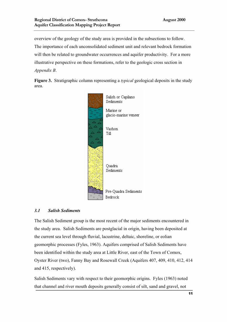
Regional District of Comox- Strathcona August 2000 Aquifer Classification Mapping Project Report
overview of the geology of the study area is provided in the subsections to follow.
The importance of each unconsolidated sediment unit and relevant bedrock formation
will then be related to groundwater occurrences and aquifer productivity. For a more
illustrative perspective on these formations, refer to the geologic cross section in
Appendix B.
Figure 3. Stratigraphic column representing a typical geological deposits in the study area.
3.1 Salish Sediments
The Salish Sediment group is the most recent of the major sediments encountered in
the study area. Salish Sediments are postglacial in origin, having been deposited at
the current sea level through fluvial, lacustrine, deltaic, shoreline, or eolian
geomorphic processes (Fyles, 1963). Aquifers comprised of Salish Sediments have
been identified within the study area at Little River, east of the Town of Comox,
Oyster River (two), Fanny Bay and Rosewall Creek (Aquifers 407, 409, 410, 412, 414
and 415, respectively).
Salish Sediments vary with respect to their geomorphic origins. Fyles (1963) noted
that channel and river mouth deposits generally consist of silt, sand and gravel, not 11
Regional District of Comox- Strathcona August 2000 Aquifer Classification Mapping Project Report
exceeding depths of 4.6 metres. His observations are supported by the data gathered
on the RDCS; although, the Salish aquifer on the northern bank of the Oyster River
mouth (Aquifer 412) appears to exceed nine metres in depth.
The Salish Sediment aquifers of the study area have generally been deposited through
fluvial processes. These formations typically consist of sand, gravel, silt and clay that
have been created by rivers and streams. Seashore deposits laid postglacially are far
more varied in composition. They may consist of woody debris, clay, silt, sand, gravel
and boulders. It is suspected that Aquifer 407 may comprise sediments deposited in
this fashion. Further field study would be necessary to confirm this observation.
The Salish Sediments of the RDCS appear to yield moderate to high volumes of
water, with reported yields ranging from 0.19 to 41 L/sec. Several high volume wells
are located in these formations at Oyster River, Base Flats and Rosewall Creek. The
permeability of these sediments is not well documented, but likely varies greatly
among different formations.
Because Salish Sediments are recent on a geologic time scale, they are shallow and
exposed at the land surface. All aquifers comprising Salish Sediments in the RDCS
are considered to be highly vulnerable to surface contamination.
3.2 Capilano Sediments
Capilano Sediments are similar in origin and composition to Salish, yet they were
deposited during the last glacial recession, while the sea level was somewhat higher
(Fyles, 1963). Capilano Sediments, being associated with a previous sea level, tend to
appear at elevations above 180 metres (Fyles, 1963; EBA, 1994). This group of
sediments is typically found deposited atop a layer of marine sediments that blankets
much of the study area (see subsection 3.3, Marine/ Glacio-Marine Veneer).
Capilano Sediment deposits vary in composition and level of sorting. Generally,
these deposits consist of clay, silt, sand, gravel, stones, woody debris, peat and
seashells (Fyles, 1963). However, sediment deposits may contrast highly, some
consisting of predominately clay and others of sand and stoney gravel. Furthermore, a
deposit’s geomorphic origins, predictably, establishes its level of sorting and bedding
12
Regional District of Comox- Strathcona August 2000 Aquifer Classification Mapping Project Report
characteristics. Modes of deposition of Capilano Sediments include shoreline,
lacustrine, deltaic and fluvial.
Capilano Sediments comprising sand and gravel may contain large groundwater
reserves within the study area. A large sand and gravel Capilano deposit near Maple
Lake (Aquifer 417) is thought to contain a high volume of water. Deposits adjacent to
the Oyster River, Cougersmith and Wilfred Creeks have yet to be developed, but may
also be productive groundwater formations. These deposits require further
exploration to determine their respective levels of productivity, for little information
currently exists.
Capilano Sediments are evidence of recent geomorphic events. They have been
exposed to weathering and erosive forces, yet have not been overlaid by any
significant overburden. Hence, Capilano, like Salish Sediment aquifers, lack the
protective covering of an impermeable layer; and therefore, they are generally
considered to be vulnerable to contamination.
3.3 Marine/ Glacio-Marine Veneer
At the end of the most recent glaciation the sea inundated much of the study area.
During this time marine sediments were deposited before Vancouver Island
issostatically readjusted in elevation relative to sea level. This veneer includes
sediments deposited in marine or glacio-marine environments; both of these
geomorphic origins would result in the fine textured veneer evident over much of the
RDCS.
These marine deposits range in depth from a few centimetres to approximately nine
metres. They are composed of stoney, till-like clay, often appearing on water well
drill logs as hard pan or till. They are often oxidized near the surface, becoming red-
brown in colour, but at depth they may appear blue-grey.
Although this marine veneer yields little to no water, it has made an impact on the
classification of several aquifers in the RDCS. Because this sediment horizon can
exceed depths of several metres, and due to its apparently low permeability, it may be
a significant protective covering of those aquifers beneath it. As such, its presence
has reduced the vulnerability rating of several underlying aquifers. It should be noted,
13

Regional District of Comox- Strathcona August 2000 Aquifer Classification Mapping Project Report
however, that this veneer is very thin in some locations and may not provide adequate
protection to safeguard a water supply. A site specific investigation is necessary in
such cases.
3.4 Vashon Till
The Vashon Till in the study area is a thick formation that covers much of the Alberni
Valley and Coastal Lowland (Fyles, 1963), and extends to the northern most limit of
the study area. The term ‘Vashon’ refers to the uppermost (youngest) sheet of glacial
drift in the region. As such, it includes any glacial formations that proceeded the
Quadra Sediments (see subsection 3.5, Quadra Sediments) (Fyles, 1963).
This till group is composed of hard packed silt, clay, sand, gravel and stones. It is
generally grey and may reach a depth of 30 metres (Fyles, 1963). Although this
formation is not thought to yield large volumes of water, along the Island Highway
between Fanny Bay and Royston and again between Merville and Oyster River the
weathered surface of the till and marine veneer above it may yield amounts suitable
for gardening, or perhaps drinking water (see section five, Unclassified Areas of
Potential Aquifers). It is likely that these wells yield low volumes of water and
possibly go dry in the summer. More typically however, this formation is a confining
layer that provides a protective shield to the extensive, water-bearing Quadra
Sediments that generally lie below it.
3.5 Quadra Sediments
Quadra Sediments exist in several locations in the study area. Clague (1977) noted
that this formation appears in large areas below the 100 metre contour interval, lying
east of the Beaufort Range and extending to the Strait of Georgia. Notably, in the
RDCS study area an extensive Quadra Sand aquifer (Aquifer 408) spans from Comox
Harbour north to Black Creek, and laterally from the Strait of Georgia to the Tsolum
River. Other water-bearing Quadra deposits include Aquifers 416, 419 and 421.
The Quadra Sediments consist of three sediment horizons, each of which has a
different geomorphic origin. The lower Quadra unit is generally comprised of marine
clays, and above it rests a more recently deposited unit of plant-bearing silt, sand and
gravel. Last, a thick upper horizon of water-bearing, fine to medium grained white 14
Regional District of Comox- Strathcona August 2000 Aquifer Classification Mapping Project Report
sand, with minor amounts of gravel rest below Vashon Till. The upper-most sand
horizon appears to the most productive water source, although all Quadra Sediments
may potentially bear water.
The Ministry of Environment, Lands and Parks (1994) noted that this formation has
proven yields of six litres per second, yet this yield value may be even higher in some
areas. Moreover, Aquifer 408 (the most extensive groundwater formation in the
RDCS) has a median well yield of 0.63 litres per second. It is, therefore, felt that this
geologic formation has proven itself to be highly productive in locations, and also
relatively secure from contamination due to the thick blanket of Vashon Till that
covers it.
3.6 Pre-Quadra Sediments
Although no unconsolidated aquifers have been classified below the Quadra horizon,
there is evidence that productive aquifers may lay below. As noted in Geologic Cross
Section Two: Piercy Creek to Little River (Appendix B), two bands of “Pre-Quadra”
sediments lay below the Quadra, the lower of which appears to be water-bearing.
Moreover, the Ministry of Transportation and Highways (MoTH) has provided test
hole data for the Cumberland Interchange that indicates that a Pre-Quadra sediment
horizon exits north of Maple Lake1. This deposit may be water-bearing (see Aquifer
Worksheet 417 in Appendix A). Very little water well data exist for this formation,
and that which does exist tend to be insufficient to competently delineate an aquifer
boundary. Therefore, the appended aquifer worksheets have been annotated where
Pre-Quadra Sediments have been encountered in lieu of fully classifying this
formation.
3.7 Nanaimo Group (Bedrock)
Lying beneath the study area is a bedrock formation that consists largely of shale,
sandstone, coal and conglomerate of the late Cretaceous (63-135 million years ago)
(Fyles, 1963; MELP, 1994; Muller, 1968). Exposed in various locations, the bedrock
of the RDCS study area is generally of the Nanaimo Group (Muller, 1968). Although
15
Regional District of Comox- Strathcona August 2000 Aquifer Classification Mapping Project Report
bedrock underlies the entire study area, the bedrock has only been developed for
water in three areas (Aquifers 411, 413, and 420).
Because the bedrock in the RDCS tends to occur deep below a mantle of
unconsolidated sediments, it is generally protected from contaminants. However, in
numerous locations bedrock outcrops reveal that this geological formation can also be
vulnerable to surface contamination. Aquifer Vulnerability Indices (AVI) were
calculated for each of the three delineated bedrock aquifer in the study. AVI is a
methodology that can be applied to individual wells in order to determine their
vulnerability to contamination based on the thickness and permeability of their
overburdens. 2 The AVI revealed that although Aquifers 413 and 420 denote high AVI
values (i.e., low vulnerability to contamination), bedrock Aquifer 411 is highly
vulnerable to contamination because of its thin overburden.
4.0 Aquifers of the Comox-Strathcona Regional District
The following section provides a brief description of all aquifers identified and
classified in the RDCS. Included is information pertaining to aquifer geology, size,
level of development, and the rationale behind the assigned vulnerability
classification. An assessment of the level of confidence of each delineated area and
classification has also been included to illustrate any foreseeable limitations inherent
to this exercise.
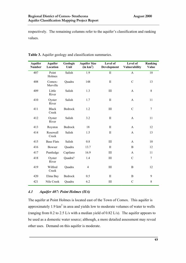
The table below provides a summary of each identified aquifer’s geologic formation
and classification (Table 3). In the first column is the aquifer number, which has no
quantitative value (i.e., Aquifer 407). These numbers are related to MELP’s aquifer
database, and are assigned in the order that each aquifer is classified. The second
column describes its general location. The third and fourth columns shows the
geologic unit that the aquifer likely belongs to as well as their approximate areas
1 MoTH has determined that the “Pre-Quadra” Sediment encountered is of the Cowichan Head Formation. Although it is likely that this is also the case elsewhere in the study area, not enough information exists to make this determination. 2 Although the AVI methodology is a useful indicator of aquifer vulnerability, it should not be considered quantitative proof of vulnerability. A more detailed evaluation of any aquifer is still necessary. The AVI values noted in this instance, however, appear reasonable.
16
Regional District of Comox- Strathcona August 2000 Aquifer Classification Mapping Project Report
respectively. The remaining columns refer to the aquifer’s classification and ranking
values.
Table 3. Aquifer geology and classification summaries.
Aquifer Number
Aquifer Location
Geologic Unit
Aquifer Size (in km2)
Level of Development
Level of Vulnerability
Ranking Value
407 Point Holmes
Salish 1.9 II A 10
408 Comox-Merville
Quadra 148 II C 13
409 Little River
Salish 1.3 III A 8
410 Oyster River
Salish 1.7 II A 11
411 Black Creek
Bedrock 1.2 III C 7
412 Oyster River
Salish 3.2 II A 11
413 Royston Bedrock 18 II A 12
414 Rosewall Creek
Salish 1.5 II A 13
415 Base Flats Salish 0.8 III A 10
416 Bowser Quadra 13.7 II B 12
417 Puntledge Capilano 16.9 III A 11
418 Oyster River
Quadra? 1.4 III C 7
419 Wilfred Creek
Quadra 4 III B 12
420 Elma Bay Bedrock 0.5 II B 9
421 Nile Creek Quadra 6.2 III C 8
4.1 Aquifer 407: Point Holmes (IIA)
The aquifer at Point Holmes is located east of the Town of Comox. This aquifer is
approximately 1.9 km2 in area and yields low to moderate volumes of water to wells
(ranging from 0.2 to 2.5 L/s with a median yield of 0.82 L/s). The aquifer appears to
be used as a domestic water source; although, a more detailed assessment may reveal
other uses. Demand on this aquifer is moderate.
17
Regional District of Comox- Strathcona August 2000 Aquifer Classification Mapping Project Report
The aquifer is overlain by a coastal sand dune formation, which does not appear to
yield sufficient volumes of water for domestic use. The overburden has a median
thickness of six metres, and consists of loose, fine to medium grained sand. As a
result, these overlying sediments do not provide a great deal of protection from
surface contamination. Below the dune formation is an unconsolidated deposit that is
likely a member of the Salish Sediment group. These sediments are recent, and were
likely deposited through shoreline processes. These water-bearing deposits contain
sand, gravel, silt and clay.
The aquifer at Point Holmes was delineated based on 21 water well records, field
survey, surficial geology mapping (Fyles, 1960), aerial photos, and groundwater
research previously completed by the Groundwater Section. It is felt that the aquifer
boundaries illustrated were delineated with a high level of confidence.
4.2 Aquifer 408: Comox-Merville (IIC)
Aquifer 408 is an extensive Quadra deposit that extends from Comox Harbour, to
Black Creek. It is estimated that the aquifer is greater than 148 km2. Present in this
aquifer there are two Provincial observation wells (Observation Wells 280 and 285),
which monitor water levels and chemistry. Information pertaining to these wells can
be obtained from the Groundwater Section’s website
(http://www.elp.gov.bc.ca/wat/gws/obswell/).
A layer of marine clay overlies this aquifer. This veneer is generally thin, yet may
exceed 1.5 metres in areas. Beneath the marine clay a layer of Vashon Till, which
may reach a thickness of several metres, blankets much of the aquifer. This geologic
arrangement offers adequate protection against surface contamination; however, in
areas surrounding Comox, Kye Bay, Merville and Williams Beach the Vashon Till
layer is not present, leaving this Quadra Sand aquifer vulnerable at these locations.
Aquifer 408 is moderately productive, although yield rates vary highly across the
aquifer. Yields range from 0.02 to 31.6 L/s, but have a median of 0.63 L/s. It is likely
that this aquifer could support high volume withdrawals in certain areas. Further
study would is required to identify such sites.
18
Regional District of Comox- Strathcona August 2000 Aquifer Classification Mapping Project Report
The western and northern perimeters of the aquifer are not entirely understood. The
northern extent of the aquifer was delineated largely based on area of development
and surface topography. However, although the Quadra Sediments may extend
beyond the recorded boundary, is likely that they produce marginal amounts of water
north of the delineated area. Additional well records may increase the confidence of
this aquifer’s edges, yet they are deemed to be reasonable.
This aquifer was delineated using 489 water well records, surficial geology mapping
(Fyles, 1960), the Memoirs of the Geological Survey of Canada (Clague, 1977), and
groundwater studies previously completed by the Ministry of Environment, Lands and
Parks, Groundwater Section. The developed portions of this aquifer are well
understood, yet the western and northern perimeters of the sand deposit require further
assessment.
4.3 Aquifer 409: Little River (IIIA)
The aquifer at Little River is a small (1.3 km2) surficial sand and gravel deposit that
yields low volumes of water (well yields range from 0.19 to 0.63 L/sec). The sand
and gravel deposit that occurs here is of the Salish group, having been formed
postglacially through fluvial or coastal processes.
This aquifer lacks a protective layering of impermeable sediments. Moreover, this
sand and gravel deposit is shallow and unconfined, resulting in a high level of
vulnerability to surface contamination.
Aquifer 409 was delineated based on 13 water well records and groundwater reports
previously completed by MELP’s, Groundwater Section. Fyles’ (1960) Surficial
Geology: Courtenay provided a reliable boundary for the deposit. Groundwater well
records were then used to confirm this information. It is thought that its boundaries
were established at a high level of confidence.
4.4 Aquifer 410: South Oyster River (IIA)
Aquifer 410 is a small aquifer (1.7 km2). It lies adjacent to the south bank of the
Oyster River at its mouth, comprising Salish Sediment. It represents the southern
extent of a larger Salish deposit that also occupies the northern bank of the Oyster
19

Regional District of Comox- Strathcona August 2000 Aquifer Classification Mapping Project Report
River. The river, however, is considered to be a groundwater divide, creating two
aquifer units.
The aquifer is similar in size to other Salish aquifers, yet it denotes atypically high
well yields. Well records indicate a range of yields from 0.5 to 18.93 L/sec, and a
median yield of 2.0 L/sec. Based on this information Aquifer 410 is considered to be
highly productive.
Consistent with other Salish Sediment aquifers, Aquifer 410 is highly vulnerable to
surface contamination. It lacks a protective, low permeability, geologic cover and has
a shallow water table.
Eleven groundwater well records were used to classify this aquifer. As well, surficial
geology mapping (Fyles, 1960) and previously compiled reports created by the
Groundwater Section were utilised to delineate its boundaries.
4.5 Aquifer 411: Black Creek (IIIC)
The aquifer at Black Creek is a bedrock aquifer with an area of at least 1.2 km2. The
Oyster River area is entirely underlaid by bedrock, portions of which have proven to
be productive aquifers. However, these bedrock areas were considered in isolation
due to the lack of groundwater development between them. Also, this bedrock
formation appears to vary greatly in depth, indicating that the bedrock topology may
be quite variable. Additional data may reveal more complete information regarding
their connectivity.
Groundwater yields from this formation are low to moderate. The range of reported
well yields is 0.04 to 1.3 L/s, while the median well yield is 0.44 L/s. Although these
volumes are low, they are high when compared to other bedrock aquifers in the study
area.
Aquifer 411 has a low level of vulnerability to contamination from surface sources.
This rating was determined due to the thickness of the marine veneer and Vashon Till
that cover the formation. This overburden has a range of reported depths of 1.8 to
22.6 metres, with a median thickness of 4.7 metres. An AVI was calculated for the
wells in this bedrock aquifer to further assess its vulnerability, which also indicated a
low level of susceptibility to contamination. 20
Regional District of Comox- Strathcona August 2000 Aquifer Classification Mapping Project Report
4.6 Aquifer 412: North Oyster River (IIA)
Aquifer 412 is comprised of Salish Sediments and is located north of the mouth of the
Oyster River. As was mentioned in the Aquifer 410 description, the Oyster River is
assumed to be a groundwater divide that separates these adjacent aquifers.
This aquifer is slightly larger in size (3.2 km2) than neighbouring Aquifer 410.
However, water well records indicate that Aquifer 412 is less productive, denoting
moderate yields. Well yields range from 0.4 to 3.2 L/s, with a median value of 2.0
L/s. However, further groundwater exploration may reveal that the capacity of this
aquifer may be more similar to that of Aquifer 410 to the south.
Consistent with other Salish Sediment aquifers, Aquifer 412 is highly vulnerable to
surface contamination, because it is unconfined and has a shallow water table.
This aquifer was delineated based on forty-nine groundwater well records, surficial
geology mapping (Fyles, 1959) and previously compiled studies completed by the
Groundwater Section.
4.7 Aquifer 413: Royston (IIA)
Aquifer 413 is a large bedrock formation (greater than 18 km2) located east of
Royston, B.C. It spans in a northeast direction, and ends at the Puntledge River.
The Royston aquifer is located in sedimentary bedrock, likely of the Nanaimo Group
– Comox Formation (Muller, 1965; MoTH, 1999). A thin layer of marine or glacio-
marine sediments overlies it (Fyles, 1959); however, this overburden is highly
variable in thickness.
This aquifer is typical of bedrock aquifers in the study area. It yields low volumes of
water, ranging from 0.03 to 0.95 L/s. The median reported well yields in this aquifer
is 0.09 L/s. It is moderately developed with low water demands, earning it a
development class of II.
Aquifer 413 is considered vulnerable to contamination; however, the range in
thickness of the overlying marine clay is quite variable. The thickness of the
confining layer ranges from 0 to 12.5 metres. The median of the reported depths is
4.0 metres, which reveals Aquifer 413’s high level of vulnerability. In addition, AVI
21
Regional District of Comox- Strathcona August 2000 Aquifer Classification Mapping Project Report
values for the bedrock wells ranged between -5.3 and 4.4, averaging 0.94 – indicating
an extremely high level of vulnerability. This evaluation was deemed to be somewhat
exaggerated, yet AVI shows that the aquifer is at least somewhat vulnerable to
contamination.
This aquifer was delineated based on 22 water well records. Furthermore, surficial
geology mapping (Fyles, 1959), Island Highway construction reports (EBA, 1999;
MoTH, 1999) and a field survey were used to identify the boundary of this formation.
The dashed line that was used to illustrate the edge of this aquifer generally represents
the area of groundwater development; however, it is likely that this bedrock formation
extends beyond the indicated aquifer limits.
4.8 Aquifer 414: Rosewall Creek (IIA)
Aquifer 414 is located south of Fanny Bay in the Rosewall Creek deltaic deposit.
Rosewall Creek is a small stream that originates in the Beaufort Range. The aquifer is
small (1.5 km2) and extends from the Island Highway to the Baynes Sound. Although
this aquifer lies outside of the RDCS, it was included to assess how it relates to other
coastal sediments. Aquifer 414 yields large quantities of water with no documented
quality concerns.
Emerson Groundwater Consulting in 1998 prepared a detailed assessment of this
aquifer, making several observations concerning the surficial geology. It was noted
that the deltaic deposit consists of sand and gravel with scattered silt lenses. The
aquifer extends 30 metres in depth, but thins along its edges. These sediments are of
the Salish group, having been deposited after the dropping of sea level. As is
expected with Salish Sediments, Aquifer 414 is vulnerable to contamination.
Aquifer 414 has very high groundwater yields, ranging from 3.8 to 41.0 L/s, with a
median well yield of 33.4 L/s. It is thought that additional high capacity wells could
be established in this aquifer.
The boundaries of this aquifer were delineated based on ten groundwater well records,
on site evaluations, Emerson (1998), surficial geology mapping (Fyles, 1962 and
1963) and aerial photos.
22
Regional District of Comox- Strathcona August 2000 Aquifer Classification Mapping Project Report
4.9 Aquifer 415: Base Flats (IIIA)
Aquifer 415 is small (less than 1 km2). It is located at Base Flats, South of Buckley
Bay at the mouth of the Tsable River.
The Base Flats formation is consistent with other Salish Sediment deposit. It is
fluvial in origin, and forms a delta in Baynes Sound. Well records reported to MELP
indicate that these sediments are gravelly sand, cobbles and river mud. The surficial
geology becomes more complex upstream from the delineated portion of the map
area. Here, Capilano Sediments rest atop valley colluvium, ground moraine, and
bedrock – these formations have not been explored for groundwater potential.
The Ministry of Environment, Lands and Parks possesses a single well record for this
Salish deposit. It indicates that the aquifer may have potential for high volume
withdrawals (well yield: 6.3 L/sec). Further assessment would be necessary to
confirm this potential, yet this yield is consistent with yields of other Salish aquifers
(see Aquifers 410, 412 and 414).
Also consistent with other Salish Sediment aquifers, the Base Flats formation is
vulnerable to contamination. Although the depth to the groundwater table is not
known, it appears to be quite shallow. The aquifer also lacks a protective overburden.
The Base Flats aquifer was delineated using two groundwater well records, surficial
geology mapping and reports (Fyles, 1962 and 1963), aerial photographs and a site
evaluation. Although only two well records were attainable, the surficial nature of
this deposit improved the ease with which it could be delineated.
4.10 Aquifer 416: Bowser (IIB)
Aquifer 416 is located in the vicinity of the town of Bowser, south of Maplegaurd
Point. It underlies a coastal lowland area extending to the sea.
The aquifer at Bowser occupies a large (13.7 km2) and productive Quadra Sediment
deposit. The sands encountered here tend to be fine, brown to grey, gravelly and
plant-bearing. Atop these Quadra deposits there is a variable arrangement of
overburdens. Notably, well records indicate that no overburden exists over a portion
23
Regional District of Comox- Strathcona August 2000 Aquifer Classification Mapping Project Report
of the Quadra Sediments, yet in other areas Vashon Till and marine veneer thickly
coat the lowlands.
Although the median water yield for this formation is a moderate 1.3 L/s, there is an
indication that the aquifer may be able to support greater pumping rates. The range of
well yields is reported to be between 0.31 L/s and 12.6 L/s with no reported incidence
of quantity concerns.
Aquifer 416 denotes a moderate level of vulnerability. However, as was mentioned
the protective overburden layer is spatially variable, leaving some areas highly
vulnerable to contamination while others are not. As a result careful attention to site
specific surficial geology is warranted.
This groundwater formation was delineated and classified based on 40 well records,
surficial geology (Fyles, 1962 and 1963). The inland perimeter of the aquifer was
dashed because the spatial extent of the Quadra Sands is not certain there. Further
exploration and assessment would be necessary to establish a more definite boundary.
4.11 Aquifer 417: Puntledge (IIIA)
Aquifer 417 is geographically situated between Maple Lake, and Comox Lake, south
of the Puntledge River. It is modestly sized (16.9 km2).
This aquifer is thought to yield large volumes of water. Although few well records
are available that would indicate its productivity, it is known that at least ten
groundwater springs exist in this deposit (these springs have not been mapped due to
concerns expressed by landowners in the area).
While only Capilano Sediments have been delineated in this classification, MoTH has
gathered information during the planning phases of the Cumberland Interchange
which indicates that a Quadra Sand deposit exists below portions of Aquifer 417
(EBA 1999). The hydrogeologic relationship between these porous layers has not
been determined.
Based on knowledge of the Quadra Sands and the visible evidence of ample
groundwater in the area, it is felt that the underlying Quadra Sand aquifer represents a
large water storage supply. This groundwater body, however, is made vulnerable to
24
Regional District of Comox- Strathcona August 2000 Aquifer Classification Mapping Project Report
contamination due to the high level of permeability of the overlying Capilano
Sediments. Although a layer of less permeable Vashon Till lies between these
sediments, it is thin or absent in some locations, lessening its effectiveness as a
defense against surface contamination. This Quadra Sand deposit likely extends north
to the Puntledge River and abuts against Aquifer 411 to the east.
Aquifer 417 was delineated based on MoTH data (EBA, 1999), studies completed on
the occurrences of groundwater springs (Kreye et al., 1996) and surficial geology
mapping (Fyles, 1960). The dashed lines approximated on the aquifer classification
mapsheet correspond to the available surficial geology mapping. Additional data are
required to understand the properties of this aquifer better.
4.12 Aquifer 418: Oyster River (IIIC)
Aquifer 418 is located on the south bank of the Oyster River immediately west of the
Oyster-Little River confluence. It is small in size, measuring 1.4 km2.
This aquifer requires further examination to determine its geological properties. It is
thought that marine sediments, Vashon till, and Capilano Sediments overlay the
immediate area. The water-bearing formation noted here, however, is a sand and
gravel deposit of uncertain origins (possibly Quadra). The Oyster River appears to
define the northern extent of the Quadra Sediments, so it is speculated that this is the
northern most productive Quadra aquifer in the area.
Well records submitted to MELP pertaining to this aquifer illustrate low yields (0.28,
0.4 and 0.6 L/sec). But, more information is required to accurately assess productivity
and the level of demand placed on this groundwater formation. The level of
groundwater development in this area is low.
The thickness of the confining layers above Aquifer 418 ranges from 11.4 to 33.5
metres, while the median static water level is 19.2 metres. Based on this evidence
Aquifer 417 is considered to have a low susceptibility to surface contamination
25
Regional District of Comox- Strathcona August 2000 Aquifer Classification Mapping Project Report
4.13 Aquifer 419: Wilfred Creek (IIIB)
The aquifer at Wilfred Creek is immediately south of the RDCS, and enclosed by the
Wilfred Creek valley. The Creek emerges south of Ships Peninsula, flowing into
Baynes Sound.
Aquifer 419 is 4 km2 in size, and yields large volumes of water. The range of
reported groundwater well yields is from 0.95 L/s to 31.55 L/s, while the median yield
is 14.83 L/s. It appears that the greatest yields are attained from the area adjacent to
the mouth of Wilfred Creek. Four large capacity wells have been mapped at this
location, placing a high level of demand on the aquifer.
The aquifer is comprised of Quadra Sediments. EBA (1994) noted that this deposit
contains clay, silt and sand of marine origins. Overlying this aquifer is a more recent
Salish deposit and a veneer of marine or glacio-marine sediments, which range in
depth from 1.5 to 7.6 metres. Given this information Aquifer 419 denotes a moderate
level of vulnerability to contamination.
The delineation and classification of this groundwater unit is based on 23 water well
records, EBA (1994), surficial geology mapping (Fyles 1962) and a field survey.
4.14 Aquifer 420: Elma Bay (IIB)
The aquifer at Elma Bay is a small bedrock aquifer (0.5 km2). It is located adjacent to
the coast, approximately one kilometre south of the mouth of the Oyster River.
Aquifer 420 likely belongs to the Nanaimo Group – Comox Formation (Muller,
1965). As mentioned in the Aquifer 411 discussion, this area is underlaid by bedrock
at shallow depths. At various locations groundwater wells have encountered bedrock,
yet the level of development between them is low. Each of these aquifers have been
considered to be discrete hydrogeologic units because of this, although the bedrock
aquifers may prove to be interconnected given additional data. Aquifer 420 exhibits
evidence of moderate groundwater yields, which range from 0.06 L/s to 6.1 L/s. The
median reported well yield is 1.26 L/s.
Overlying Aquifer 420 is a Salish Sediment deposit. Although there may be
additional sediments below the Salish, their origins and properties are not well
26
Regional District of Comox- Strathcona August 2000 Aquifer Classification Mapping Project Report
understood. The overburden ranges in depth from 8 to 19 metres, and provides a
moderate level of protection from surface contamination. However, portions of the
aquifer are not sufficiently shielded.
This aquifer was delineated based on nine water well records and surficial geology
mapping (Fyles, 1959). The dashed line that was used to illustrate the edge of this
aquifer generally represents the area of groundwater development, however, it is
likely that this bedrock formation extends beyond the indicated geological limits.
4.15 Aquifer 421: Nile Creek (IIIC)
The aquifer delineated between Nile Creek and Thames Creek is found in a Quadra
deposit that measures approximately 6.2 km2. This aquifer marks the southern extent
of the study area, lying outside of the RDCS.
This Quadra Sediment deposit is not well documented here. MELP has seven water
well records for this hydrologic unit, yet the data quality is poor. Only one record
contained yield and lithographic data, noting a withdrawal rate of 0.02 L/s, indicating
low productivity. The thickness of the overburden was also recorded, depicting a
thick layer of Vashon Till measuring 7.6 metres.
The delineation of this aquifer was based on seven groundwater well records, surficial
geology (Fyles, 1959 and 1963) and a field survey. It is known that Quadra
Sediments are present here, yet the low level of development and incomplete well
logs made the classification of this aquifer difficult. Additional data would facilitate a
greater degree of certainty in this assessment.
5.0 Unclassified Areas of Potential Aquifers
There are several areas in the RDCS that may prove to be aquifers. Although some
data were available to support their presence, these data were either poor quality or
incomplete. These potential aquifers can only be classified with additional
information – three such areas were identified. These areas are described in the text
to follow.
27
Regional District of Comox- Strathcona August 2000 Aquifer Classification Mapping Project Report
5.1 Ships Point
Ships Point peninsula protrudes into Baynes Bay, south of Fanny Bay. The point is
less that one square kilometre, of shallow bedrock that has been covered in what
appear to be Salish Sediments.
Ships Point residents receive their water supply from the Ships Point Improvement
District, thereby eliminating the need to explore for groundwater at this location.
MELP has one water well record that indicates that a well was drilled deep into the
shale of the point. Although the well has now been abandoned, it may be that other
wells were also drilled into this bedrock formation and went unreported. Moreover,
bedrock in the area near Ships Point is known to yield low to moderate volumes of
water. The same may hold true for this peninsula as well.
More information pertaining to the thickness and composition of the overburden
above this potential bedrock aquifer is necessary to competently assess the bedrock
aquifer’s vulnerability to contamination. Nevertheless, Fyles (1962) has indicated
that Ships Point is covered in a Salish deposit, which likely indicates that any bedrock
aquifer below is somewhat vulnerable to contamination.
5.2 Island Highway Communities
Along much of the Island Highway between Fanny Bay and Royston and again from
Merville to Oyster River there are several shallow, domestic water wells. However,
the well records that correspond to these wells are problematic for several reasons.
The primary concern with these records is that many are dated and the wells they
represent may no longer be in use, therefore, relying on these records may inflate the
level of groundwater development in these areas. Second, many of these logs lack
important pieces of data, particularly regarding stratigraphy and water yields.
Also importantly, these wells are typically shallow wells dug into Vashon Till or
Marine Veneer. These wells draw minor amounts of surface seepage and frequently
become dry. In areas where this is the case aquifers were not delineated. As a result,
the Black Creek, Union Bay and Royston areas where unclassified. This is not to say
that groundwater contamination should not receive consideration in these locations;
28
Regional District of Comox- Strathcona August 2000 Aquifer Classification Mapping Project Report
on the contrary. The author recommends that these areas are studied further to better
understand the local hydrogeology.
5.3 Maple Lake
As mentioned in the previous section, there is significant evidence that additional
aquifers are present underneath the Capilano Sediment aquifer at Maple Lake
(Aquifer 417). Further information and assessment are necessary to classify these
formations, but the evidence strongly suggests that more than one productive source
of groundwater is present here. It is likely that a highly productive deposit of Quadra
Sediments underlies Aquifer 417, while an older Pre-Quadra formation may yield
moderate to high volumes of water beneath the Quadra deposit. Bedrock in the area is
also near to the ground surface, yet unexplored for water. It too may yield volumes of
groundwater suitable for domestic uses.
6.0 Aquifer Discussion
Several observations can be made about the aquifers identified in the RDCS; these
will be discussed in the section to follow.
The level of development of groundwater resources is generally low in the study area.
This is largely because several communities in the RDCS are supplied by surface
water. During the classification phase of the assessment no I aquifers were identified
(Table 1). Of the fifteen aquifers eight were designated as II, and the remaining
seven as III. However, several groundwater users are currently withdrawing large
volumes from aquifers at Oyster River (Aquifer 410), Rosewall Creek (414), Base
Flats (415), and Wilfred Creek (419). These users include aquaculture, agriculture,
water bottling and industry.
Of the 15 aquifers identified in the Regional District eight were classified as highly
vulnerable (i.e., those in the A vulnerability sub-class). These aquifers also tended to
be moderate to highly productive, yet small in area. Hence, management of these
water sources is a priority due to their susceptibility to surface contamination, but any
management strategies adopted will be contained to are relatively small geographic
areas.
29
Regional District of Comox- Strathcona August 2000 Aquifer Classification Mapping Project Report
The highly vulnerable aquifers of the study area are generally surficial deposits of
sand and gravel (Salish or Capilano) with the exception of Aquifer 413 (bedrock).
Moreover, these deposits tend to appear on the banks or at the mouths of rivers and
streams. As such, the water quality and quantity of these watercourses is intimately
connected to that of the aquifers they share a geographic area with.
Bedrock aquifers are patchily distributed throughout the RDCS. Although bedrock
exists everywhere at depth, it tends not to be well developed in areas due, in part, to
the presence of productive unconsolidated aquifers at or nearer to the ground surface
in those areas. Bedrock sources of groundwater tend to yield low to moderate
volumes of water in the study area, which is typical for these formations elsewhere
(B.C. Environment, 1994). There were three bedrock aquifers classified in the
Regional District, two of which are not deemed to be vulnerable, while the bedrock
aquifer near Royston (413) is highly vulnerable. Isolated bedrock wells were noted
throughout the study area, yet they were not generally delineated as aquifers unless
additional well records or corroborating evidence supported doing so. This was an
issue particularly in the area north of Merville.
The Quadra Sediments are a significant water source in the region. These
unconsolidated sediments cover a large area and yield moderate to large volumes of
water. Fortunately, the Quadra Sediments also tend to generally appear deep below
one or two confining layers, reducing their vulnerability to contamination (except
Aquifer 416 at Bowser, just south of the RDCS boundary). Quadra Sediments,
however, are often unconfined in local areas where the overlying Vashon Till has
been eroded away, and for this reason site specific assessment of these aquifer is
essential in order to ensure that they are not degraded.
7.0 Conclusion
The purpose of this project was to delineate and classify aquifers in the areas of
known groundwater development in the Regional District of Comox-Stratchcona
electoral areas A, B, C, and D. Fifteen aquifers were identified and classified. These
aquifers were mapped digitally in ArcInfo 7.0, and this report was prepared to
accompany the aquifer classification mapping.
30
Regional District of Comox- Strathcona August 2000 Aquifer Classification Mapping Project Report
The aquifers documented exhibited several trends. First, nearly half of those
formations were sand and gravel deposits that occurred along (present or past) rivers
and streambeds. These fluvial deposits can potentially yield large volumes of water,
they are highly vulnerable to contamination, yet small in size. Another geologic
formation that proved important was the Quadra Sediments. This formation is
significant due to its expansiveness and potentially high yields. These Quadra
Sediments occur throughout the study area south of the Oyster River and are generally
confined by a thick layer of glacial and marine sediments. They are, therefore, not
typically vulnerable to contamination. The remaining aquifers were bedrock, had low
yields and were generally not very vulnerable to contamination.
8.0 Three areas have been identified where insufficient data exist to effectively delineated aquifers. These areas have low levels of groundwater development or the data available were insufficient. In the case of the Island
Highways Communities it was noted that residents are drawing small quantities of groundwater seepage from surficial deposits of till and clay. These communities’ wells often experience water shortages due to the geologic formations that they are drawing their water from. For the purpose of this study, these areas were not considered to be productive aquifers and therefore were not delineated or classified. These, as well as any of the delineated aquifers, may be revisited in the future if more well records become available.
8.0 Recommendations
This project was initiated out of a need to better incorporate groundwater into the
Regional District’s activities. Although this assessment did not seek to study
31
Regional District of Comox- Strathcona August 2000 Aquifer Classification Mapping Project Report
alternative management strategies, several recommendations have arisen pertaining to
what the next steps may be for the Regional District in order to better accommodate
groundwater concerns. This list is not exhaustive, but includes incorporating public
education, partnerships, regulations, monitoring, and further study and data collection.
8.1 Public Education
A challenge in groundwater management is creating the awareness necessary to
motivate individuals to steward their water supplies. But, groundwater is often poorly
understood, which can limit the effectiveness of such initiatives. Moreover, if the
Regional District seeks to implement aggressive management alternatives, the public
may resist due to their lack of knowledge of the vulnerability and value of this
resource. Therefore, educating the public is a logical first step in ensuring better
groundwater management practices.
The format of any public education that arises should attempt to reach the broadest
spectrum of groundwater users and community groups, while carefully considering
the needs of those groups. Likely public education topics may include water
conservation, well maintenance and testing for private wells, proper use and disposal
of contaminants (i.e., pesticides, fertilisers, paint, petroleum, etc.) and knowledge of
the aquifers in the regional district area. A great deal of contact with land owners,
stewardship groups, businesses and government agencies will likely be necessary, yet
the effort could build support for any proceeding courses of action.
More specifically, it is advised that the Regional District begin by presenting their
aquifer classification mapping to the public, Regional Board, local health region,
municipal planners, Nanaimo MELP staff, local stewardship groups, or local water
well drillers. An additional course of action is to pursue jointly developing a well
stewardship package with MELP, which addresses proper well maintenance and water
testing, conservation and chemical storage and use.
8.2 Partnerships
Several groups and individuals in the RDCS have a vested interest in maintaining the
quality and quantity of groundwater in the study area. Given the limited resources of
each of these groups in isolation, by working together groundwater is likely to be 32
Regional District of Comox- Strathcona August 2000 Aquifer Classification Mapping Project Report
managed far more successfully. In addition, throughout the data collection phase of
this project it was found that agencies like the Ministry of Highways and
Transportation (North Island District and the Vancouver Island Highway Project), the
Ministry of Health, industry and water well drillers have a great deal of relevant
information for the area. In the future these sources may be willing and able to
provide input on groundwater issues. Furthermore, several community groups have
expressed interest in the mapping products that have been created. These groups may
also prove to be an invaluable asset in stewarding the groundwater resource of the
RDCS and in taking on some of the public education initiatives.
One potential partnership is for the RDCS to require well records be submitted by the
property owner in order to receive new building permits, and for the records to then
be submitted to MELP. Information on new well records may allow the aquifer
boundaries to be refined and may reveal aquifers that have not been developed before.
8.3 Planning and Regulation
The Regional District has several legislative and regulatory powers that it can access
in order to improve groundwater management. An inventory of the RDCS aquifers
has been created and can now assist in decision making efforts. This information is
spatial in nature and can now be added to the Regional District’s Atlas. Although the
information produced in this report is not intended to be used at a site specific level,
the maps reveal several areas of low groundwater vulnerability. These areas may now
be incorporated into the Official Community Plan (OCP) and Local Area Plan (LAP)
as areas of desired growth. Contrarily, a closer focus on those areas of high
vulnerability is desirable.
Regulating activities that could potentially lead to aquifer contamination is a likely
course of action. For example, building permits may be restricted to those landowners
that can first prove to have a safe and well-maintained domestic water source. These
initiatives, however, will require a greater degree of insight than this report can
provide. Further assessment is required. The RDCS can also outline Development
Permit Areas over vulnerable aquifers whereby the hydrogeological impacts of any
new developments need to be assessed by the developer. These efforts can then be
33
Regional District of Comox- Strathcona August 2000 Aquifer Classification Mapping Project Report
supported by establishing stricter building standards for subdivisions to minimize the
effects on recharge areas of the aquifers. Last, another course of action is encourage
community well water systems to initiate Well Protection Plans (see the Groundwater
Section web site for a complete guide to creating a Well Protection Plan at
http://www.elp.gov.bc.ca/wat/gws/well_protection/wellprotect.html).
8.4 Monitoring
Water quality does not appear to be a pressing issue in the Regional District at the
moment. However, baseline data has not been recorded for several of the aquifers
identified. In order to monitor fluctuations in groundwater quantity and quality a
network of observation wells is advised. This network may provide the baseline
quality data required to identify contamination and also provide an early response to
contamination, if it should occur.
A high degree of technical expertise, resources and planning would be required to
establish a network that is both comprehensive and cost-effective. It is therefore
recommended that the RDCS pursue the assistance of the Ministry of Environment,
Lands and Parks – Groundwater Section in exploring their monitoring needs.
Given the financial constraints of operating an observation well network, two
effective, cost-reducing measures are recommended. First, the Regional District is
encouraged to seek community groups to assist in sampling. Community-based
groundwater sampling and monitoring programs have been successful in several
communities (i.e., Grand Forks and Osoyoos). Second, the Regional District may not
wish to implement a network that includes all aquifers immediately. The
classification of the aquifers provides insight into which aquifers should receive
priority in this regard (i.e., Aquifers 409, 410, 412, 413, 415, 417). A more
comprehensive evaluation is required, however, to make this determination.
8.5 Further Data Collection and Study
Qualifying many of these recommendations there were notes that further study is
required. Although the information that the RDCS ultimately gathers will vary based
on the course of action that they accept, three areas of study are recommended:
34
Regional District of Comox- Strathcona August 2000 Aquifer Classification Mapping Project Report
1. Identify the recharge areas of classified aquifers.
2. Determine direction of groundwater flow in areas of concern.
3. Compile more detailed vulnerability mapping in areas deemed as sensitive or under high development pressures.
This report also identified areas where data were lacking. By devoting time towards
collecting these records a better understanding of these areas may be at hand. The
Regional District may pursue several low-cost options to this end. A first step may be
to require that well record be submitted during residential construction and
remodelling. Or, MoTH may be co-operative in sharing its files pertaining to proof of
potable water for new subdivisions. Maintaining data quality will have to be foremost
in these efforts though. Data standards must be addressed in any agreement reached.
MELP staff may be useful in establishing guidelines for data standards.
35
Regional District of Comox- Strathcona August 2000 Aquifer Classification Mapping Project Report
References
B.C. Environment, 1994. Groundwater Resources of British Columbia. Ministry of Environment, Lands and Parks and Environment Canada. Victoria, British Columbia.
B.C. Environment, 1996. The Identification and Delineation of Bedrock Aquifers in British Columbia. Ministry of Environment, Lands and Parks and Environment Canada. Victoria, British Columbia.
Clague, J.J., 1977. Quadra Sand: A Study of the Late Pleistocene Geology and Geomorphic History of Coastal Southwest British Columbia. Geological Survey of Canada. Ottawa, Canada. Paper 77-17.
EBA Engineering Ltd., 1994. Groundwater Well Field Impact Assessment and Management Plan for Stelling Road Fish Hatchery. EBA File Number 0802-82028.
EBA Engineering Consulting Ltd. 1999. Water Well Survey and Impact Study. File Number 802-98-82718.
Emerson Groundwater Consultants. 1998. Natural Glacier Water California License Application.
Fyles, J.G., 1959. Surficial Geology: Oyster River, British Columbia. Geological Survey of Canada. Ottawa, Canada. Map 49-1959.
Fyles, J.G., 1960. Surficial Geology: Courtenay, British Columbia. Map 32-1960. Geological Survey of Canada. Ottawa, Canada.
Fyles, J.G., 1962. Surficial Geology: Horne Lake, British Columbia. Geological Survey of Canada. Ottawa, Canada.
Fyles, J.G., 1963. Surficial Geology: Horne Lake and Parksville Map Areas. Vancouver Island, British Columbia. Memoir 318. Geological Survey of Canada. Ottawa, Canada.
Holland, S.S., 1964. Landforms of British Columbia. British Columbia Department of Mines and Petroleum Resources Bulletin No. 48.
Kreye, R., and M. Wei, 1994. A Proposed Aquifer Classification System for Groundwater Management in British Columbia. Ministry of Environment, Lands and Parks, Water Management Division. Victoria, British Columbia. pp. 68, 7 maps.
Kreye, R., K. Ronneseth and M. Wei, 1996. Defining the Source Area of Water Supply Springs. Ministry of Environment, Lands and Parks – Hydrology Branch.
Leaming, S.F., 1968. Sand and Gravel in the Strait of Georgia Area. Paper 68-60. G.S.C. Ottawa, Canada.
Regional District of Comox- Strathcona August 2000 Aquifer Classification Mapping Project Report
Ministry of Transportation and Highways. 1999. Route Geotechnical Investigation: Island Highway South Courtenay Connector. File number 6M2-20-03.
Muller, J.E., 1968. Geology: Alberni, British Columbia. Map 17-1968. Geological Survey of Canada. Ottawa, Canada.
Muller, J.E. and Atcheson, M.E., 1971. Geology, History and Potential of Vancouver Island Coal Deposits. Paper 70-53. Geological Survey of Canada. Ottawa, Canada.
Ronneseth, K., 1985. Regional Groundwater Potential for Supplying Irrigation Water: Union Bay to Oyster River. British Columbia Ministry of Environment, Lands and Parks. Water Management Division. Victoria, British Columbia.
Ronneseth, K., 1994. Classification of Aquifers in the Fraser River Basin (Draft Report). Ministry of Environment, Lands and Parks, Water Management Division. Victoria, British Columbia. 23 pp., 8 maps.
Van Stempvoort, D., L. Ewert, L. Wassenaar, 1992. AVI: A Method for Groundwater Protection Mapping in the Prairie Provinces of Canada. Prairie Provinces Water Board, Regina, Saskatchewan.
Wei, M., 1995. Emerald Estates Groundwater Supply – Saratoga Beach, B.C. Memorandum, Ministry of Environment, Lands and Parks – Water Management Branch. File 0317588.
Wei, M., 1998. Evaluating AVI and DRASTIC for Assessing Pollution Potential in the Lower Fraser valley, British Columbia: Aquifer Vulnerability and Nitrate Occurrence. Ministry of Environment, Lands and Parks, Groundwater Section. Victoria, British Columbia.

Regional District of Comox- Strathcona August 2000 Aquifer Classification Mapping Project Report
Glossary3
Alluvial deposits - Any sediment, including clay, silt, sand, gravel or similar unconsolidated material deposited in a sorted or semi-sorted condition by a watercourse.
Alluvial fans - A fan-shaped accumulation of alluvium deposited at the mouth of a ravine or at the juncture of a tributary stream with the main stream.
Aquifer - An aquifer is a geologic formation, group of formations or part of a formation containing enough saturated permeable material to produce significant amounts of water to wells and springs. (See also confined aquifers or artesian aquifers and unconfined aquifers.)
Aquifer Classification System - The system classifies aquifers on the basis of their level of development and vulnerability to contamination. It is map-based and provides a ranking value for aquifers using hydrogeologic and water use criteria.
Aquifer vulnerability - A measure of how vulnerable an aquifer is to contamination.
Aquifer vulnerability Index - A methodology that can be applied to determine the vulnerability of an aquifer. It is quantitative and is based on the thickness of differing overburden types. A numerical index score is generated which can be used to compare groundwater formations.
Aquifer vulnerability mapping - Mapping the vulnerability of an aquifer to contamination from sources. Vulnerability mapping does not consider the type of land use above an aquifer, only the intrinsic vulnerability of the aquifer, typically based on the type, thickness, and extent of geologic materials overlying an aquifer, depth to water, and type of aquifer materials.
Artesian aquifer - See confined aquifer.
Artesian well - A well obtaining its water from an artesian or confined aquifer in which the water level in the well rises above the top of the aquifer. The water level in a flowing artesian well rises above the land surface.
AVI - see Aquifer vulnerability index.
Bedrock - Rock underlying soil and other unconsolidated material.
Colluvial deposits - Weathered, unconsolidated materials transported and deposited by gravity.
Confined aquifer - Confined is synonymous with artesian. A confined aquifer or an artesian aquifer is an aquifer bounded both below and above by beds of considerably lower permeability than that existing in the aquifer itself. The groundwater in a
3 Several glossary entries were excepted from Groundwater Resources of British Columbia (MELP, 1994. Additional entries were added, but they have not been annotated as such.
Regional District of Comox- Strathcona August 2000 Aquifer Classification Mapping Project Report
confined aquifer is under pressure that is significantly greater than that existing in the atmosphere.
Confining bed - A bed of impermeable material stratigraphically adjacent to one or more aquifers. Confining bed is now used to replace terms such as “aquiclude”, “aquitard” and “aquifuge”.
Contaminant - Solute which through human action intrudes into the hydrologic cycle.
Contamination - Impairment of natural water quality by chemical or bacterial pollution as a result of human activities. The degree of contamination allowed before an actual hazard to public health is created will depend upon the intended end use, or uses of the water.
Cretaceous -The most recent geologic period in the Mesozoic Era.
Diamicton - Any deposited sediment of glacial origins. These sediments include ice contact deposits and non-ice contact deposits (i.e., glacio-fluvial, glacio-lacustrine, glacio-marine, etc.)
Discharge area -An area where groundwater and water in the unsaturated zone is released to the ground surface, to surface water or to the atmosphere.
Drawdown - The variation in the water level in a well prior to commencement of pumping compared to the water level in the well while pumping. In flowing wells drawdown can be expressed as the lowering of the pressure level due to the discharge of well water.
Drift (glacial) - Glacial drift includes all rock material in transport by glacier ice, the deposits made by glacier ice and all materials mainly of glacial origin deposited in the sea or in glacial melt water bodies including materials rafted in by ice bergs or transported indirectly in the water itself. Glacial drift therefore includes till, rock fragments and stratified drift.
Drilled well - A well that is constructed with a drilling rig, such as an air rotary or cabletool drilling rig.
Dug well - A well that is dug by hand or excavated by backhoe. Dug wells are usually shallow.
Eolian - Of or relating to wind. Eolian sediments, therefore, are those that were deposited by air currents.
Floodplain - The flat land adjacent to a river, formed by deposition of fluvial materials.
Flowing artesian well - A well where the water level is above the ground surface.
Fluvial deposits - Deposits related to a river or stream.
Regional District of Comox- Strathcona August 2000 Aquifer Classification Mapping Project Report
Fracture - A break or crack in the bedrock.
Geometric mean – A mathematical measure of central tendency. It is the nth root, usually the positive nth root, of a product of n factors.
Geomorphology - Geomorphology is the science dealing with the origin and evolution of landforms.
Glacial drift - See Drift (Glacial)
Glacio-fluvial deposits - Deposits related to the joint action of glaciers and meltwater streams.
Groundwater - Water in the zone of saturation, that is under a pressure equal to or greater than atmospheric pressure.
Groundwater divide - The uppermost boundary of a groundwater basin.
Groundwater table - That surface below which rock, gravel, sand or other material is saturated. It is the surface of a body of unconfined groundwater at which the pressure is atmospheric.
Hydraulic gradient - T he slope of the groundwater level or water table.
Hydraulic head - The level to which water rises in a well with reference to a datum such as sea level.
Hydrogeology - Study of groundwater in its geological context.
Hydrologic cycle - The continued circulation of water between the ocean, atmosphere and land is called the hydrologic cycle.
Ice contact deposits - Drift sediment deposited in contact with its supporting ice.
Igneous rocks - Rocks that solidified from molten or partly molten materials, that is from a magma or lava.
Impermeable - Impervious to flow of fluids.
Isostatic rebound - Pressure applied to the Earth forces the mass downward until a new balance is reached. Removal of the pressure allows the mass to migrate back, restoring equilibrium. In the context of glaciers, the pressure is the growth of a continental ice sheet - removal of the pressure is ice sheet decay.
Kettle - A closed depression made in drift by a mass of underlying ice melting.
Lacustrine deposits - Sediments laid down in a lake. Includes gravelly deposits at the margin and clay in deeper water. Sediments commonly show seasonal banding or varve clays.
Regional District of Comox- Strathcona August 2000 Aquifer Classification Mapping Project Report
Level of groundwater development - The level of groundwater use of an aquifer relative to the aquifer’s ability to replenish itself.
Lithology - All the physical properties, the visible characteristics of mineral composition, structure, grain size etc. Which give individuality to a rock.
Marine deposits - Mostly silt and clay materials deposited under a marine environment.
Median - Being in the middle or in an intermediate position.
Mesozoic - Geologic era preceding the Cenozoic Era. The Mesozoic Era was a time when the rocks of the Triassic, Jurassic and Cretaceous Systems were deposited.
Moraine - An accumulation of unsorted-unstratified glacial drift mainly till, deposited by glacial ice. Drift deposited in the flanks of a valley glacier form a lateral moraine. Glacial deposits which have accumulated at the front of a glacier form a terminal moraine. Deposits of drift which have been dragged along beneath the ice form ground moraine.
Observation well - A well constructed for the objective of undertaking observations such as water levels, pressure readings and groundwater quality.
Outwash deposits - Stratified drift deposited by meltwater streams flowing away from melting ice.
Overburden - The layer of fragmental and unconsolidated material including loose soil, silt, sand and gravel overlying bedrock, which has been either transported from elsewhere or formed in place.
Palaeozoic - Geological era preceding the Mesozoic Era. The Palaeozoic is a major division of geologic time and it includes in descending order the Permain, Carboniferous, Devonian, Silurian, Ordovician and the Cambrian.
Perched water table - A separate continuous body of groundwater lying (perched) above the main water table. Clay beds located within a sedimentary sequence, if of limited aerial extend, may have a shallow perched groundwater body overlying them.
Permeability - The property of a porous rock, sediment or soil for transmitting a fluid, it is a test of the relative ease of fluid flow in a porous medium.
Permeable - The property of a porous medium to allow the easy passage of a fluid through it.
Piezometer - Pressure reading and measuring instrument connected to a short sealed off length of a drill hole or hydrogeologic unit.
Piezometric surface - Imaginary surface defined by the elevation to which water will rise in wells penetrating confined aquifers.
Regional District of Comox- Strathcona August 2000 Aquifer Classification Mapping Project Report
Pleistocene - The period following the Pliocene during which an ice sheet covered the greater part of North America. Named by Lyell in 1839.
Pollution - Contamination of the environment with objectionable or offensive matter.
Porosity - The volume of openings in a rock, sediment or soil. Porosity can be expressed as the ratio of the volume of openings in the medium to the total volume.
Potential well yield - An estimate of well yield generally above the existing yield rate or test rate, but considered possible on the basis of available information, data and present well performance.
Public involvement - The process by which the views of all parties interested in a proposed government decision are integrated into the decision-making process. It is a dynamic process that attempts to identify, record, analyze and synthesize ideas, concerns, needs and values before recommendations are given to government decision makers.
Pumping interference - The condition occurring when a pumping well lowers the water level in a neighbouring well.
Pumping test - A test conducted by pumping a well to determine aquifer or well characteristics.
Quaternary - The period of geologic time that follows the Tertiary. The Quaternary includes the Pleistocene and Recent Periods and is part of the Cenozoic Era.
Recharge area (groundwater) - An area where water infiltrates into the ground and joins the zone of saturation. In the recharge area, there is a downward component of hydraulic head.
Salt water intrusion - Movement of salty or brackish groundwater into wells and into aquifers previously occupied by fresh or less mineralized groundwater either through upconing or sea water encroachment.
Sandstone - A sedimentary rock composed of mostly sand sized particles.
Saturated zone - The subsurface zone in which all voids are ideally filled with water under pressure greater than atmospheric.
Sea water encroachment - The lateral landward movement of sea water into wells and freshwater aquifers.
Sedimentary rocks - Rocks formed from consolidation of loose sediments such as clay, silt, sand, and gravel.
Shale - A fine-grained sedimentary rock, formed by the consolidation of clay, silt, or mud. It is characterized by finely laminated structure and is sufficiently indurated so that it will not fall apart on wetting.
Regional District of Comox- Strathcona August 2000 Aquifer Classification Mapping Project Report
Specific capacity - The rate of discharge of a water well per unit of drawdown. Specific capacity can be expressed as L/s/m of drawdown.
Specific conductance (groundwater)- The ability of a water sample to conduct an electric current. Specific conductance is related to the concentration of dissolved solids in a water sample. A rapid determination of TDS of a water sample can be made by measuring the electrical conductance.
Sorting - Processes through which sediments drop out of suspension based on their size and/or mass. The result is a stratified layering of sediments based on particle characteristics.
Static water level - The level of water in a well that is not being influenced by groundwater withdrawals. The distance to water in a well is measured with respect to some datum, usually the top of the well casing or ground level.
Stratigraphy - The study of rock strata, especially the distribution, deposition, and age of sedimentary rocks.
Surficial deposits - Deposits overlying bedrock and consisting of soil, silt, sand, gravel and other unconsolidated materials.
Sustained yield - Rate at which groundwater can be withdrawn from an aquifer without long term depletion of the supply.
Tertiary - Geologic period of the Cenzoic Era and that period prior to the Quaternary.
Till -Till consists of a generally unconsolidated, unsorted, unstratified heterogeneous mixture of clay, silt, sand, gravel and boulders of different sizes and shapes. Till is deposited directly by and underneath glacial ice without subsequent reworking by meltwater.
Topography - The configuration of a surface including its relief and the position of its natural features.
Transmissivity - Rate at which water is transmitted through a unit width of an aquifer under a unit hydraulic gradient. Transmissivity values can be expressed as square metres per day (m2/day), or as square metres per second (m2/s).
Unconfined aquifer - An aquifer in which the water table is free to fluctuate under atmospheric pressure.
Unconsolidated deposits - Deposits overlying bedrock and consisting of soil, silt, sand, gravel and other material which have either been formed in place or have been transported in from elsewhere.
Unsaturated zone - The zone between the land surface and the water table. The pore spaces, interstices, contain water at less than atmospheric pressure, and also air and other gases. Perched groundwater bodies (local saturated zones) may exist in the unsaturated zone.
Regional District of Comox- Strathcona August 2000 Aquifer Classification Mapping Project Report
Water balance (hydrologic budget) - A record of the outflow from, inflow to, and storage in a hydrologic unit like an aquifer, drainage basin etc.
Watershed - A catchment area for water that is bounded by the height of land and drains to a point on a stream or body of water, a watershed can be wholly contained within another watershed.
Water table - See groundwater table.
Wellhead protection - Protection of the recharge (or capture zone) area of a pumping well.
Well interference - When the area of influence, or the cone of depression around a water well comes into contact with or overlaps that of a neighbouring well pumping from the same aquifer and thereby causes additional drawdown or drawdown interference in the wells.
Well seals - Cover for the top of the well.
Well screen - A cylindrical filter used to prevent sediment from entering a water well. There are several types of well screens, which can be ordered in various slot widths, selected on the basis of the grain size of the aquifer material where the well screen is to be located. In very fine grained aquifers, a zone of fine gravel or coarse sand may be required to act as a filter between the screen and the aquifer.
Well yield - The volume of water discharged from a well in litres per minute (L/min), litres per second (L/s),or cubic metres per day (m3/day).
Zone of saturation -See saturated zone.
Regional District of Comox- Strathcona August 2000 Aquifer Classification Mapping Project Report
Appendix A: Aquifer Worksheets
The following appendix contains the raw data and statistical analysis for the aquifers
observed in the Regional District of Comox-Strathcona. They served as the basis for
determining each aquifer’s class and rank.
Regional District of Comox- Strathcona August 2000 Aquifer Classification Mapping Project Report
Appendix B: Geologic Cross Sections of Selected Comox-Strathcona Aquifers
Regional District of Comox- Strathcona August 2000 Aquifer Classification Mapping Project Report
Appendix C: Aquifer Classification Mapsheets
Regional District of Comox- Strathcona August 2000 Aquifer Classification Mapping Project Report