Embed Size (px)
Citation preview

Saskatchewan Geological Survey 1 Summary of Investigations 2012, Volume 2
Regional Data Compilation and Three-dimensional Geological Modelling in the Vicinity of the Shield Margin, Hanson Lake Area
R.M. Morelli
Morelli, R.M. (2012): Regional data compilation and three-dimensional geological modelling in the vicinity of the Shield margin, Hanson Lake area; in Summary of Investigations 2012, Volume 2, Saskatchewan Geological Survey, Sask. Ministry of the Economy, Misc. Rep. 2012-4.2, Paper A-8, 12p.
Abstract This report describes ongoing work on sub-Phanerozoic interpretive mapping south of the Flin Flon and Glennie domains, which focussed this year on a relatively detailed case study of rocks in the greater Hanson Lake area. This particular area was chosen from within the larger sub-Phanerozoic project area because of its location along the Shield margin and because it encompasses a relatively greater density of historical bedrock and drillhole data, a direct consequence of its substantiated potential for economic volcanogenic massive sulphide mineralization. This study centres on compilation of newly acquired and historical data of a variety of types, including lithological, structural, geophysical, and lithogeochemical data. These collective data, derived from both exposed and buried (sub-Phanerozoic) rocks, are also being integrated into a three-dimensional (3-D), digital geological model of the Hanson Lake area. The goals of this interpretive model are to provide a visualization tool for understanding the geological architecture of the area, as well as to provide a comprehensive, updatable 3-D platform within which new data can subsequently be integrated and analyzed as they become available. Products to be released in the short term from this work will include a sub-Phanerozoic drillhole database, a lithogeochemical database, and a suite of interpreted 3-D ‘objects’ (surfaces, curves, etc.) that reflect the initial geological interpretation of the area based on currently available data.
Keywords: Hanson Lake assemblage, Reindeer Zone, Flin Flon Domain, Shield margin, sub-Phanerozoic, Paleoproterozoic, volcanogenic massive sulphide (VMS), three-dimensional (3-D).
1. Introduction Following a prior interpretation (Leclair et al., 1997), interpretive mapping of the sub-Phanerozoic basement south of the Flin Flon and Glennie domains was initiated in 2008 (Morelli and MacLachlan, 2008) to provide an improved geological context for mineral exploration in the buried basement rocks. Based primarily on interpretation of geophysical data, inspection of available drillcores, and extrapolation from the exposed Shield, sub-Phanerozoic ‘subdomain’ maps were released for the area south of the Flin Flon Domain (Morelli, 2010a) and Glennie Domain (Morelli and Corrigan, 2011). These provisional interpretive maps portray the lithological, structural, and metamorphic character of the sub-Phanerozoic rocks at a regional scale and serve to delineate general areas of increased mineral potential.
Whereas these existing sub-Phanerozoic maps provide a regional characterization of the buried rocks, they do not provide a sufficient level of detail to allow identification of specific lithological units or structures that might be important exploration targets. This is due mainly to the paucity of existing data in most parts of the sub-Phanerozoic map area that would allow for this scale of mineral vectoring. There are, however, smaller pockets within the larger map area within which a greater amount of historical exploration work has been done and, consequently, for which a more detailed level of interpretation is possible. The objective of the current (2012) phase of the project, as outlined in this report, is to perform a case study on one such pocket of increased data density in the sub-Phanerozoic map area to determine the level of detail that can be achieved. The case study involves two broader components: 1) compilation of the available data and publication of these data as an integrated set; and 2) interpretation of these compiled data within a three-dimensional (3-D) digital model. The greater Hanson Lake area (Figure 1), including both the exposed Shield around Hanson Lake and sub-Phanerozoic rocks of the adjacent Hanson geophysical subdomain 1 (Morelli, 2010a), was selected as the study area for this project because of several factors, including: 1) its location at the Shield margin; 2) the existence of comprehensive regional (1:20 000 scale) map coverage of the exposed rocks; 3) a demonstrated potential for economic volcanogenic massive sulphide (VMS) mineralization; 4) a relatively high drillhole density in the sub-Phanerozoic rocks; and 5) as a consequence
1 Originally defined as the ‘Hanson Lake Domain’, it has since been redesignated as a geophysical subdomain.
Saskatchewan Geological Survey 2 Summary of Investigations 2012, Volume 2
Figure 1 – Lithotectonic domain map of northern Saskatchewan (Saskatchewan Geological Survey, 2003) showing the location and geological setting of the Hanson Lake data compilation/detailed three-dimensional modelling project.
Reindeer Zone
108°110°
102°104°106° 60°
54°
59°
55°
56°
58°
57°
60°
59°
58°
56°
57°
55°
54°
Lake Athabasca
Black Lake
Pasf ield Lake
Cree Lake
Wollaston
Lake
Reindeer
Lake
Lac La Ronge
AmiskLake
NW
HWPW
MUDJATIK
MUD
JATIK
NOLAN
TRAINDODGE
TANTATO
BEAVERLODGE
LLOYD
CARSWELL ATHABASCA BASIN
WATH
AMAN
BATHOLIT
H
LA R
ONG
E
PETER L
AKE
GLE
NNIE
KISSEYNEW
FLINFLON
VIR
GIN
RIV
ER
KISSEYNEW
WOLLA
STON
IW
= Nistowiak Window
HW PW
IW NW
= Hunter Bay Window= Pelican Window
Archean Tectonic Windows (Sask craton)
= Iskwatikan Window
TALTSON
ROTTENS
TONE
TabbernorFault
WapawekkaLake
DeschambaultLake
Hanson Lake
detailed2012
case study(Figure 2)
Phanerozoic cover
sub-Phanerozoic project area
ZEMLAK

Saskatchewan Geological Survey 3 Summary of Investigations 2012, Volume 2
of the other factors, a high density of geological information relative to other areas of the sub-Phanerozoic map area.
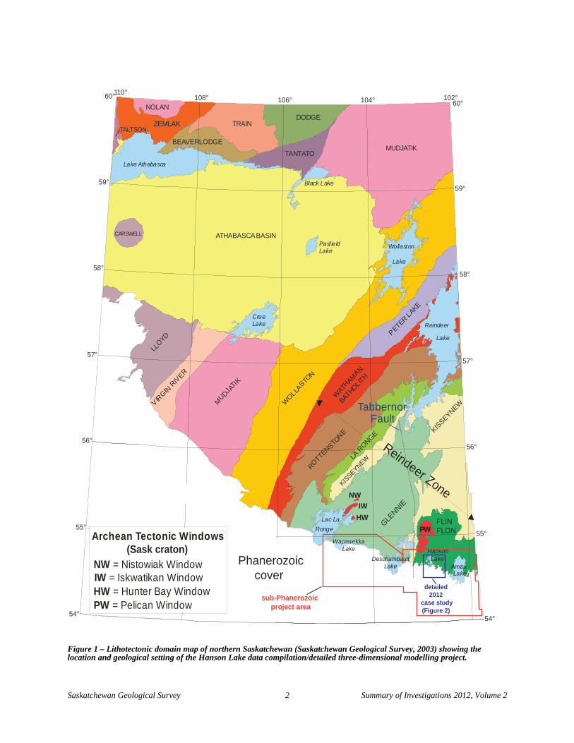
2. Geological Setting Exposed rocks of the Hanson Lake area are situated in the westernmost Flin Flon Domain of the Reindeer Zone, in the internides of the Trans-Hudson Orogen (Figure 1). The area is dominantly underlain by Paleoproterozoic volcanoplutonic rocks 2 of the Hanson Lake assemblage (Maxeiner et al., 1999), which form part of an allochthonous thrust sheet that was overthrust on Archean rocks of the Sask craton during the Trans-Hudson Orogeny (Lewry et al., 1990). In contrast to most of the juvenile volcanic rock assemblages of the Flin Flon–eastern Amisk Lake area to the east (Reilly, 1994), volcanic rocks of the exposed Hanson Lake assemblage are felsic dominated (Figure 2). Maxeiner et al. (1999) interpreted the assemblage to comprise: a lower sequence of island arc mafic tholeiites; an upper sequence of evolved, calc-alkaline dacites and rhyolites deposited in an island arc at ca. 1875 Ma; and an overlying sequence of clastic sedimentary rocks consisting of mainly psammite and psammopelite. This supracrustal sequence, or portions thereof, has been intruded by several igneous suites, including broadly synvolcanic (ca. 1873 Ma) biotite granite sills and garnetiferous quartz porphyry, younger (ca. 1860 Ma) feldspar (±quartz) porphyry, and the compositionally variable ca. 1844 Ma Hanson Lake pluton (ibid.). A recent U-Pb detrital zircon study on a psammitic sample from the uppermost sedimentary sequence (Morelli et al., 2010) indicated a dominance of ca. 1860 Ma detritus and a maximum depositional age of 1844 ±13 Ma for this unit. No zircon grains older than ca. 1900 Ma were identified. A separate siliciclastic sedimentary sequence in the Sturgeon-weir River area to the east (Figure 2) is of similar appearance and maximum depositional age (1841 ±11 Ma) to that exposed on Hanson Lake, and has an identical dominant mode of 1860 Ma detrital zircon (Morelli et al., 2010). Furthermore, like those at Hanson Lake, this sedimentary sequence has been intruded by a relatively late (ca. 1840 Ma?) multi-phase pluton (the ‘Snake Rapids’ pluton; Figure 2). Despite these similarities, the identification of detritus as old as 2750 Ma in the Sturgeon-weir River psammite sample, not identified in the Hanson Lake sample, leaves uncertainty in the original depositional relationship between these two sequences.
Rocks in the Hanson Lake area were subjected to lower to upper amphibolite facies regional metamorphism and multiple episodes of deformation during Trans-Hudson orogenesis. The structural character of the Hanson Lake area can best be described with reference to the regional structural history of the Reindeer Zone, as presented by Lewry et al. (1990) and Ashton et al. (2005). The dominant deformational fabric in much of the region, attributed to the D2 deformation event, is west-northwest trending and parallels contemporaneous isoclinal folds and thrust faults. These D2 structures are reoriented by two later folds sets, including characteristically north-trending, close to tight F3 folds and northeast-trending, open to gentle F4 folds. The main structural fabric in the immediate Hanson Lake area, in contrast, is northerly trending, making it difficult to distinguish between original D2 structures that have been reoriented by D3 structures and structures that originally formed during the D3 event. A notable example is the north-northeast–trending and moderately south-plunging ‘Jackpine Lake’ anticline, which affects relatively high-grade orthogneisses of the Jackpine Lake gneiss complex in the northwest part of the study area (Figure 2). This fold is described by Coleman et al. (1970) as refolding both the main regional foliation and earlier generations of minor folds, and was interpreted as an F3 fold. Subsequently, Maxeiner et al. (1995) reinterpreted it as an F2 fold. Other subparallel, major folds have been proposed near Hanson Lake, including the ‘Side Lake’ and ‘Hanson Lake’ synclines and the ‘Botham Bay’ anticline (Byers, 1957; Figure 2). Although the true timing of these folds and related structures is debatable, they are designated as F3 folds for the purposes of this study. Outcrop-scale fold interference between north-trending, isoclinal folds, possibly of D3 derivation, and later northeast-trending open (D4) folds has been noted in the eastern part of the map area along the Sturgeon-weir River (Ashton, 1992).
Variably oriented shear zones (e.g., the Botham Bay, Spruce Rapids, Sturgeon-weir shear zones) form a network in the Sturgeon-weir River area. These shear zones characteristically parallel the trend of lithological units and have been attributed to D2 deformation (Ashton et al., 2005). Contemporaneous (D2) unit-parallel shear zones are also present in the immediate Hanson Lake area, but the majority of the faults and shear zones in this area clearly truncate and cause lateral termination or offset of lithological units. These latter structures most likely originated either during D3 deformation or during a later (?D4) phase of brittle faulting associated with movement along the Tabbernor fault zone (e.g., the ‘Guyader-Chip Lake fault’; Figure 2; Byers, 1962; Coleman et al., 1970).
Many of the exposed units and structures in the Hanson Lake area can be traced southward beneath Phanerozoic cover using geophysical data. Unexposed rocks immediately south of the Shield margin in the Hanson Lake area have been assigned to the Hanson Lake geophysical subdomain (Morelli, 2010a), interpreted as the probable sub-Phanerozoic continuation of the exposed Hanson Lake assemblage. Based on drillcore observations, the sub-Phanerozoic rocks are thought to be dominated by dacitic to rhyolitic volcanic rocks, felsic porphyritic intrusions, and equigranular intrusions of varying compositions, along with subordinate mafic to intermediate volcanic rocks
2 As the preponderance of rocks in the Reindeer Zone have been metamorphosed, the prefix ‘meta’ has been omitted from this report.
Saskatchewan Geological Survey 4 Summary of Investigations 2012, Volume 2
Figure 2 – Close-up of the study area in the greater Hanson Lake area showing the geological character of the exposed Shield (from mapping by Ashton, 1990a, 1990b; Slimmon, 1992a, 1992b; and Maxeiner et al., 1994) and location of known mineral showings (from the Saskatchewan Mineral Deposit Index( SMDI) at URL <http://www.ir.gov.sk.ca/Default.aspx? DN=5c7f6d47-d9ad-4b03-b4af-21dce78e4923>; the SMDI file number is in parentheses). Red dots indicate the approximate location of drillholes examined in the 2012 field season by the author. Location of the inferred F4 fold axial trace is from Morelli (2010b). Abbreviations: BBA, Botham Bay anticline; GCLF, Guyader-Chip Lake fault; HLS, Hanson Lake syncline; JLA, Jackpine Lake anticline; and SLS, Side Lake syncline.
!!
!
!!
!
!!
!
!!
!
!!
!
!!
!!
!!
!!
!!
!!
!!
!!
!
!!
!
!!
!
!!
!
!!
!!
!!
!!
!!
!!
!!
!!
!!
!!
!!
!!
!!
!!
!!
!!
!!
!!
!!
!!
!!
!!
!!
!!
!!
!!
!!
!!
!!
!!
!!
!!
!!
!!
!!
!!
!!
!!
!
!!
!
!!
!
~~
~~
~~
~~
~~
~~
~~
~~
~~
~
~ ~ ~ ~ ~ ~ ~ ~~
~~
~~
~~
~~
~~
~~
~~
~~
~ ~ ~ ~ ~ ~ ~ ~ ~ ~~ ~ ~ ~
~~
~~
~~
~ ~ ~ ~ ~ ~ ~ ~ ~~
~~ ~ ~ ~ ~
~~
~~
~~
~ ~
~~ ~
~~
~#*
#*
#*
#*
#*
#*#*
#*
#*
#*
#*
#*
#*
#*
#*
#*#*
#*
#*
#*
#*#*
#* #*
#*
#*
#*
#*
#*
#*#*
")
#*
#*#*
#*
#*
#*
#*#* #*#*
#*
#*
#*
#*
#*
#*
#*
#*#*
#*
#*#*
#*
635000 640000 645000 650000 655000 660000
6045
000
6050
000
6055
000
6060
000
6065
000
6070
0002.5 0 2.5 5 7.5 101.25
km
$
Legend
Saskatchewan Mineral Deposit Index (SMDI) showings:
#* Ag#* Cu
#* Ni#* Pb
#* Zn
Phanerozoic sedimentary cover
Tonalite gneiss
Leucogranodiorite-leucotonalite
Granodiorite-tonalite, migmatitic
Pegmatite
Quartz-/ feldspar-/ quartz-feldspar porphyritic felsic intrusion
Greywacke, mafic wacke
Calc-silicate rock
Intermediate volcanic
Mafic volcanic
Hornblende gneiss
") silica sand
! ! ! ! F4 fold axial trace (inferred)
! ! ! F3 fold axial trace
~ ~ D2 shear zone
?D3/?D4 fault / shear zone
McIlvenna Bay deposit (2169)
Hanson Lake mine (0209)
Bluebirdprospect (0186)
Youngoccurrence (0291) Ramsay
prospect (0182)
Balsamprospect (2168)
Grid Bprospect (2211)Miskat Lake
prospect (2134)
Grid Foccurrence (0189)
Flintyoccurrence (2750)
Foran Mining Corporation 2012 drilling (DDH MR-12-03)
Copper ReefMining Corporation 2010-11 drilling
South Bay prospect (0187)
Foran Mining Corporation 2012 drilling
Hanson Lake
Hobbs Lake
Sturgeon-weir River
KerrLake
Sturgeon-weir shear zone
Botham Bay shear zone
Spruce Rapids shear zone
JLA
HLS
BBA
SLS
Hanson Lake pluton
SnakeRapidspluton
GCLF
m E m E m E m E m Em E
m N
m N
m N
m N
m N
Granodiorite-tonalite
Granite-monzogranite-quartz monzonite
Tonalite-quartz diorite
Quartz diorite-granodiorite-diorite
Diorite-quartz monzonite-monzodiorite
Gabbro-diorite
Ultramafic rock
Rhyolite
Rhyodacite
Dacite

Saskatchewan Geological Survey 5 Summary of Investigations 2012, Volume 2
and chemical sedimentary horizons. Kilometre-scale, lenticular aeromagnetic anomaly patterns that straddle the Shield margin were previously proposed (Morelli, 2010b) to reflect a variant of dome and basin–style fold interference, similar to that observed by Ashton (1992) at outcrop-scale in exposed rocks of the Sturgeon-weir River area.
Rocks of the Hanson Lake assemblage and their sub-Phanerozoic equivalents are host to a number of significant examples of VMS-style mineralization (Figure 2). The Hanson Lake (a.k.a. Western Nuclear) mine on southern Hanson Lake produced 147 300 metric tonnes (t) of ore between 1967 and 1969 with an average grade of 9.99% Zn, 5.83% Pb, 0.51% Cu, and 4.00 oz/ton Ag (Coombe Geoconsultants Ltd., 1991). The McIlvenna Bay deposit, discovered beneath 30 m of Phanerozoic cover in 1990 and currently owned by Foran Mining Corporation, is the most economically important deposit known in the area. Current Mineral Resource 3 estimates for the deposit include 9130 t in the ‘copper stockwork zone’ grading approximately 1.5% Cu and 0.45 g/t Au, and 12 510 t in the ‘massive to semi-massive sulphide zones’ grading approximately 6.3% Zn and 25 g/t Ag. Other notable historic discoveries include: the South Bay prospect, Young occurrence, Bluebird prospect, and Ramsay prospect in the exposed Shield; and the sub-Phanerozoic Balsam prospect, Grid B prospect, Flinty occurrence, Miskat Lake prospect, and Grid F occurrence.
3. Data Compilation Data compilation for this study includes a wide range of data sources and types. Regional potential field geophysical data were acquired from the Natural Resources Canada geophysical database (Natural Resources Canada, 2012a, 2012b); aeromagnetic data were originally acquired in two separate airborne surveys in 1985 (Flin Flon area survey; 300m line spacing) and 1993 (Hanson Lake survey; 500 m flight-line spacing). High-quality geological mapping coverage was previously provided by Byers (1957), Coleman et al. (1970), and Maxeiner et al. (1994) in the immediate Hanson Lake area, by Slimmon (1992a, 1992b) in the eastern Hanson Lake area, and by Johnson (1967) and Ashton (1990a, 1990b) in the southern Sturgeon-weir River area. In addition to lithological contacts, a database of structural measurements was acquired from this historical mapping and has been augmented with recent reconnaissance bedrock mapping during the present study, which served to improve familiarization with rock units and their geophysical character.
Owing to a long exploration history dating back to before 1950, a wealth of drillcore data is available for the study area. To date, around 500 drillholes have been completed in the greater Hanson Lake area. The collar locations and other general information of more than 300 of these have been added to a new drillhole database for the sub-Phanerozoic project. Over 100 of these entries also include detailed lithological information, which was extracted from original industry drill logs. Cores from many of the drillholes have been preserved by the exploration companies or in government drillcore libraries. Representative cores from several of the properties have therefore been re-examined as part of this study since 2008. In addition to physical drillcores, exploration data such as drill logs, magnetic susceptibility and electromagnetic surveys, etc. are preserved in publicly available government assessment files or have been provided directly by the exploration companies.
Another important objective of this study has been to collect and compile historical lithogeochemical data from georeferenced bedrock and drillcore samples. Historical lithogeochemical data from regional mapping programs have been compiled from Ashton (1992), Maxeiner et al. (1995), and Slimmon (2011). Data from an extensive regional geochemical sampling program in the Hanson Lake area (Parslow and Gaskarth, 1986) are included, as are those extracted from unpublished industry reports and from exploration assessment files housed by the government. In addition, over 50 research-quality, whole-rock analyses of drillcore and bedrock samples, collected since 2008, have been performed or are pending. These compiled data, which include a range of elemental suites derived from a variety of techniques, are being interpreted as a collective suite and will be released as a coherent database.
4. 3-D Geological Modelling The other major component of the current study is the cumulative integration of the compiled data into a digital 3-D geological model. The objectives of this ongoing 3-D modeling work are: a) to provide a comprehensive rock property data integration platform to which new data can be added as desired, and b) to provide an interpretive visualization tool to enhance our understanding of the exposed rocks and help with extrapolation of the exposed rocks beneath the Phanerozoic cover. This component of the study is ongoing and is considered a test case to ascertain whether a meaningful 3-D interpretation can be achieved with the available dataset. If successful, this will ultimately lead to a better understanding of both property- and regional-scale geological features and the distribution of attributes related to undiscovered mineral deposits in the area.
3 Mineral Resource includes both Indicated and Inferred Resources; consult http://www.sedar.com/homepage_en.htm for details.

Saskatchewan Geological Survey 6 Summary of Investigations 2012, Volume 2
The 3-D platform is being generated using Mira Geoscience’s Paradigm™ GOCAD® Mining Suite (‘GOCAD’) software, with modelling of individual 3-D surfaces done specifically using the ‘Sparse’ add-on module. Spatial integration and interpretation of the geochemical data is being done using ioGAS software in conjunction with the GOCAD-ioGAS link module. The use of this software combination allows for integration of all available datasets to facilitate interpretation of geological features (e.g., Figure 3) and to readily query specific rock attributes.
5. Field Work in 2012 In addition to the data compilation and 3-D modeling projects, a portion of the 2012 field season was spent inspecting cores from two recently completed drill programs on two separate properties in the study area: the Hanson Lake project and the McIlvenna Bay regional exploration project.
a) Hanson Lake Project (Copper Reef Mining Corporation)
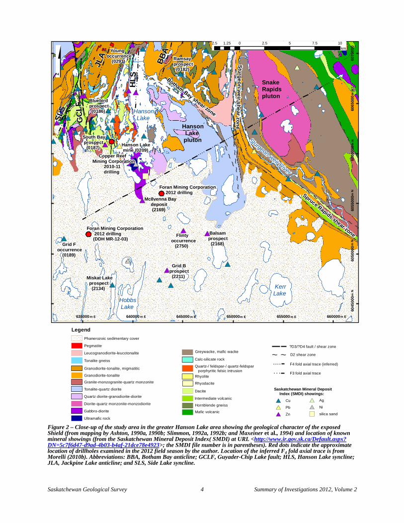
Situated on southwestern Hanson Lake (Figure 2), a total of 23 drillholes were completed in 2010-11 to test anomalies identified in a recent VTEM airborne survey and to test the lateral extent of the South Bay prospect. Drillcores from six of these were examined this summer which, with down-hole depths ranging from ~210 to 845 m, collectively provide a general perspective on the local volcanic stratigraphy of southwestern Hanson Lake. The rocks examined in drillcores are generally equivalent to those exposed at surface. Felsic volcanic rocks are the most prevalent, and volcaniclastic variants (e.g., lapilli tuff, lapillistone; Figure 4A) are common. Felsic, quartz porphyritic volcanic rocks and/or hypabyssal intrusions are also common and typically contain up to 5%, 1 to 3 mm blue quartz ‘eyes’, with or without up to 7% sub- to euhedral K-feldspar phenocrysts (Figure 4B). Distinct, massive to weakly foliated feldspar porphyritic dykes with up to 15%, 1 to 3 mm subhedral feldspar phenocrysts locally contain up to 1% quartz phenocrysts (Figure 4C). Mafic volcanic/volcaniclastic rocks, though much less common than felsic varieties, are interlayered with the felsic volcanic/porphyritic rocks in some holes (e.g., HCR-10-4 and HCR-10-5; Figure 4D); though some of these mafic intersections are clearly supracrustal, at least some are probably fine-grained mafic dykes. Garnet porphyroblasts, possibly partly reflecting regional and/or local metamorphosed alteration zones, are prevalent in many of the felsic volcanic units (e.g., Figure 4A), in places accounting for up to 15% of the rock. Other metamorphic mineral assemblages representing zones of pervasive hydrothermal alteration are prevalent in some drillholes, including chlorite-anthophyllite in mafic rocks (hole HCR-10-5) and chlorite-biotite-garnet-staurolite in rocks of uncertain protolith (HCR-11-23; Figure 4E). Zones of stringer to semi-massive sulphide mineralization were encountered in several holes (Figure 4F).
b) McIlvenna Bay Regional Exploration Project (Foran Mining Corporation)
Four drillholes were completed in the study area by Foran Mining Corporation in 2012 to test regional electromagnetic conductors identified within 7 km of the McIlvenna Bay deposit. Of these, two were drilled within 1 to 2 km and parallel to the trend of the McIlvenna Bay deposit. The other two were drilled approximately 6 km southwest of the McIlvenna Bay deposit, near the previously discovered Grid F occurrence (Figure 2), to test separate north-trending conductors with coincident magnetic highs. One drillhole (MR-12-03) of the latter pair was examined by the author this summer. This hole, drilled at a moderate (-60°) plunge to the east (077°) for 269 m, intersected Precambrian basement rocks beneath ~40 m of Phanerozoic cover. The basement core exhibits, in general, a sequence of felsic to mafic volcaniclastic rocks and sulphidic argillite, a quartz-feldspar porphyritic felsic intrusion(s), and one or more suites of crosscutting mafic dykes. The volcaniclastic rocks range from thinly layered felsic tuffs (Figure 5A), to felsic-intermediate lapilli tuffs, to mafic tuffs and lapilli tuffs (Figure 5B). In one instance, a >5 cm subinterval (?clast) containing 2 to 3%, 1 to 2 mm diameter quartz phenocrysts was observed within a felsic tuffaceous rock (Figure 5C), thereby suggesting input of proximal felsic volcanic detritus. Sulphidic argillite is thinly layered to laminated, is locally interlayered with felsic tuff, and commonly contains discordant pyrrhotite stringers (Figure 5D). A massive, quartz-feldspar porphyritic felsic intrusion (Figure 5E) was observed immediately below a fault at ~238 m and, considering its weakly foliated to massive character, is thought to postdate the more strongly deformed supracrustal sequence, though no crosscutting relationships were observed. Mafic dykes ranging from fine grained, equigranular (Figure 5F) to plagioclase porphyritic are commonly observed to crosscut other units. It is currently unclear whether these dykes represent a single or multiple suites, or whether some with less definitive contact relationships could actually be mafic volcanic flows. Chloritic alteration was observed in some of the felsic tuffaceous units, and disseminated sulphides and/or sulphidic stringers were also noted in places within the felsic tuffs. Overall, peak metamorphic conditions of the rocks in this drillhole are thought not to have exceeded greenschist facies.

Saskatchewan Geological Survey 7 Summary of Investigations 2012, Volume 2
Figure 3 – Examples of three-dimensional modelling of geological data in the Hanson Lake study area using GOCAD®. A) Plan view of the study area displaying lithological units derived from existing regional bedrock geological maps of the exposed Shield, overlain by individual foliation measurements (pink tablets) compiled from the corresponding bedrock mapping projects. These measurements aid in structural modelling of the rock units in the third dimension. The total magnetic intensity of the unexposed (sub-Phanerozoic) Precambrian rocks to the south is represented as a coloured contour map, with the Shield margin shown as a dark grey line. B) View from the southwest of traces of historical exploration drillholes (red) in the study area into the subsurface (7x vertical exaggeration). The Topographic surface of the study area is represented by a digital elevation model obtained from the shuttle radar topography mission (version 2; URL<http://www2. jpl.nasa.gov/srtm/>). C) View from the south (7x vertical exaggeration) of down-hole lithogeochemical (x-ray fluorescence) data for volcanic rock samples from the sub-Phanerozoic Balsam prospect attributed by rock type (colour; classification of Pearce, 1996) and relative Zn content (size). The sample points are attributed and displayed using ioGAS software in conjunction with the GOCAD-ioGAS link module. Lithogeochemical data were compiled from publicly available exploration assessment files housed by the government.
A
B
C
10 km
Shield margin
Saskatchewan Geological Survey 8 Summary of Investigations 2012, Volume 2
Figure 4 –Representative drillcore photographs from Copper Reef Mining Corporation holes drilled northwest of Mine Bay on Hanson Lake in 2010-11: A) garnetiferous felsic lapilli tuff, diamond-drill hole (DDH) HCR-10-2, ~130 m; B) quartz-feldspar porphyritic rhyolite, containing 1 to 3 mm K-feldspar phenocrysts (e.g., pink arrows) and 1 mm blue quartz phenocrysts (e.g., blue arrows), DDH HCR-10-5, ~20 m; C) massive feldspar porphyritic felsic dyke, DDH HCR-10-4, ~232 m; D) mafic lapilli tuff, DDH HCR-10-5, ~260 m; E) chlorite-biotite-garnet-staurolite alteration rock of uncertain protolith, DDH HCR-11-23, ~560 m; and F) semi-massive sulphide surrounding white quartz nodules in dacite, DDH HCR-10-1, ~156 m. Note: all depths listed in figure captions are down-hole depths.
A
B
C D
E F
B

Saskatchewan Geological Survey 9 Summary of Investigations 2012, Volume 2
Figure 5 – Photographs of drillcores from Foran Mining Corporation 2012 drillhole MR-12-03: A) thinly layered felsic tuff, ~174 m; B) mafic lapilli tuff, ~79 m; C) quartz porphyritic felsic rock (clast?) within felsic tuffaceous sequence, ~143 m; D) felsic tuff transitioning to argillite with discordant sulphide (pyrrhotite) stringers, ~206 to 207 m; E) quartz-feldspar porphyritic felsic intrusion, ~243 m; and F) fine-grained, equigranular mafic dyke, ~76 m.
A B
C D
E F

Saskatchewan Geological Survey 10 Summary of Investigations 2012, Volume 2
6. Summary Recent work on sub-Phanerozoic mapping south of the Flin Flon Domain has been focussed on a more detailed investigation of the greater Hanson Lake area. This area was selected for this case study based on its strong potential for discovery of additional VMS deposits and because of the relatively large amount of geological data available for the area. This work involves two main components: 1) data compilation, involving both newly acquired and legacy lithostructural, lithogeochemical, geophysical and drillhole data, and 2) 3-D geological modelling of the compiled data. The data compilation will result in the release of both a sub-Phanerozoic drillhole database and a lithogeochemical database for the Hanson Lake area. The 3-D modelling is ongoing and, if successful, will give rise to publicly available 3-D object files showing the interpreted 3-D architecture of both exposed and sub-Phanerozoic Precambrian rocks in the Hanson Lake area.
7. Acknowledgments Sienna Johnson is thanked for providing excellent assistance this summer, both with data entry and field investigations. Foran Mining Corporation, Copper Reef Mining Corporation, and HudBay Minerals Inc. are thanked for providing access to exploration drillcores from the study area for the purpose of examination and sampling. The study also benefited from informative discussions with geologists from these companies, particularly David Fleming, Roger March, and Stephen Masson. Ralf Maxeiner provided valuable insight into many aspects of this study and, along with Ken Ashton and Bill Slimmon, contributed legacy data from past mapping programs. Informative discussions with Cliff Stanley during a site visit to McIlvenna Bay also benefited this project.
8. References Ashton, K.E. (1990a): Bedrock geology, Snake Rapids area (parts of NTS 63L-9 and -10), sheet I - northwest;
1:20 000-scale map with Summary of Investigations 1990, Saskatchewan Geological Survey, Sask. Energy Mines, Misc. Rep. 90-4.
__________ (1990b): Bedrock geology, Snake Rapids area (parts of NTS 63L-9 and -10), sheet II - southeast; 1:20 000-scale map with Summary of Investigations 1990, Saskatchewan Geological Survey, Sask. Energy Mines, Misc. Rep. 90-4.
__________ (1992): Geology of the Snake Rapids area: update; in Summary of Investigations 1992, Saskatchewan Geological Survey, Sask. Energy Mines, Misc. Rep. 92-4, p97-113.
Ashton, K.E., Lewry, J.F., Heaman, L.M., Hartlaub, R.P., Stauffer, M.R., and Tran, H.T. (2005): The Pelican Thrust Zone: basal detachment between the Archean Sask Craton and Paleoproterozoic Flin Flon–Glennie Complex, western Trans-Hudson Orogen; Can. J. Earth Sci., v42, no4, p685-706.
Byers, A.R. (1957): The Geology and Mineral Deposits of the Hanson Lake Area, Saskatchewan; Sask. Dep. Miner. Resour., Rep. 30, 47p.
__________ (1962): Major faults in western part of Canadian Shield with special reference to Saskatchewan; in Stevenson, J.S. (ed.), Tectonics of the Canadian Shield, Roy. Soc. Can., Spec. Publ. 4, p40-59.
Coleman, L.C., Gaskarth, J.W., and Smith, J.R. (1970): Geology and Geochemistry of the Hanson Lake Area, Saskatchewan; Sask. Resear. Counc., Geol. Div., Rep. 10, 156p.
Coombe Geoconsultants Ltd. (1991): Base metals in Saskatchewan; Sask. Energy Mines, Open File Rep. 91-1, 218p.
Johnson, R.L. (1967): The Geology of the Hanson Lake Area (East Half), Saskatchewan; Sask. Dep. Miner. Resour., Rep. 117, 18p.
Leclair, A.D., Lucas, S.B., Broome, H.J., Viljoen, D.W., and Weber, W. (1997): Regional mapping of Precambrian basement beneath Phanerozoic cover in southeastern Trans-Hudson Orogen, Manitoba and Saskatchewan; Can. J. Earth Sci., v34, p618-634.
Lewry, J.F., Thomas, D.J., Macdonald, R., and Chiarenzelli, J. (1990): Structural relations in accreted terranes of the Trans-Hudson Orogen, Saskatchewan: telescoping in a collisional regime?; in Lewry, J.F. and Stauffer, M.R. (eds.), The Early Proterozoic Trans-Hudson Orogen of North America, Geol. Assoc. Can., Spec. Pap. 37, p75-94.
Saskatchewan Geological Survey 11 Summary of Investigations 2012, Volume 2
Maxeiner, R.O., Sibbald, T.I.I., and Lewry, J.F. (1994): Geology of Deschambault-Tulabi-Hanson lakes area, Saskatchewan, sheet 2: east; 1:20 000-scale map with Summary of Investigations 1994, Saskatchewan Geological Survey, Sask. Energy and Mines, Misc. Rep. 94-4.
Maxeiner, R.O., Sibbald, T.I.I., Lewry, J.F., and Watters, B.R. (1995): Geology of the Deschambault-Tulabi-Hanson lakes area, southern Hanson Lake Block, northern Saskatchewan (part of NTS 63L/10, /11, /14, /15); Geol. Surv. Can., Open File 3218, 136p.
Maxeiner, R.O., Sibbald, T.I.I., Slimmon, W.L., Heaman, L.M., and Watters, B.R. (1999): Lithogeochemistry of volcano-plutonic assemblages of the southern Hanson Lake Block and southeastern Glennie Domain, Trans-Hudson Orogen: evidence for a single island arc complex; Can. J. Earth Sci., v36, p209-225.
Morelli, R.M. (2010a): Provisional interpretive map of sub-Phanerozoic geology, Flin Flon Domain and eastern Glennie Domain, (parts of NTS 63L and 63K); 1:200 000-scale prelim. map with Summary of Investigations 2010, Volume 2, Saskatchewan Geological Survey, Sask. Ministry of Energy and Resources, Misc. Rep. 2010-4.2, URL <http://er.gov.sk.ca/adx/aspx/adxGetMedia.aspx?DocID=11871,11458,11455,11228,3385,5460, 2936,Documents&MediaID=36853&Filename=Morelli_Sub_Phan_2010-4.2-(6).pdf>.
__________ (2010b): Update on interpretive geological mapping of the sub-Phanerozoic Flin Flon and eastern Glennie domains, Saskatchewan; in Summary of Investigations 2010, Volume 2, Saskatchewan Geological Survey, Sask. Ministry of Energy and Resources, Misc. Rep. 2010-4.2, Paper A-9, 16p, URL <http://er.gov. sk.ca/adx/aspx/adxGetMedia.aspx?DocID=11869,11868,11458,11455,11228,3385,5460,2936,Documents&MediaID=36842&Filename=A-9+Morelli.pdf>.
Morelli, R.M. and Corrigan, D. (2011): Provisional interpretive map of sub-Phanerozoic geology, Deschambault aeromagnetic survey (parts of NTS 63L/05, /06, /11, /12, /13, and /14; 73I/07, /08, /09, /10, /15, and /16); 1:200 000-scale prelim. map with Summary of Investigations 2011, Volume 2, Saskatchewan Geological Survey, Sask. Ministry of Energy and Resources, Misc. Rep. 2011-4.2, URL <http://er.gov.sk.ca/adx/aspx/ adxGetMedia.aspx?DocID=12188,11458,11455,11228,3385,5460,2936,Documents&MediaID=38791&Filename=Morelli_Sub_Phan_2011-4.2-(5).pdf>.
Morelli, R.M., and MacLachlan, K. (2008): Towards a revised geological map of buried Precambrian basement of the Flin Flon and Glennie domains; in Summary of Investigations 2008, Volume 2, Sask. Ministry of Energy and Resources, Misc. Rep. 2008-4.2, CD-ROM, Paper A-5, 22p.
Morelli, R.M., Rayner, N.M., Creaser, R.A., and DuFrane, S.A. (2010): New geochronology and isotopic tracing results from the sub-Phanerozic Flin Flon and Glennie domains; in Summary of Investigations 2010, Volume 2, Saskatchewan Geological Survey, Sask. Ministry of Energy and Resources, Misc. Rep. 2010-4.2, Paper A-10, 34p, URL <http://er.gov.sk.ca/adx/aspx/adxGetMedia.aspx?DocID=11869,11868,11458,11455,11228,3385, 5460,2936,Documents&MediaID=36843&Filename=A-10+Morelli+et+al.pdf>.
Natural Resources Canada (2012a): Canadian Aeromagnetic Data Base; Geoscience Data Repository, Geological Survey of Canada, Earth Sciences Sector, Natural Resources Canada, URL <http://www.nrcan.gc.ca/earth-sciences/products-services/geoscience-data-repository/11824>.
__________ (2012b): Canadian Geodetic Information System; Geoscience Data Repository, Geodetic Survey Division, Earth Sciences Sector, Natural Resources Canada, URL <http://www.nrcan.gc.ca/earth-sciences/products-services/geoscience-data-repository/11826>.
Parslow, G.R. and Gaskarth, J.W. (1986): Geochemistry of the Hanson Lake area, Saskatchewan; Sask. Energy Mines, Open File Rep. 86-1, 122p.
Pearce, J.A. (1996): A user’s guide to basalt discrimination diagrams; in Wyman, D.A. (ed.), Trace Element Geochemistry of Volcanic Rocks: Applications for Massive Sulphide Exploration; Geol. Assoc. Can., Short Course Notes, v12, p79-113.
Reilly, B.A. (1994): The Crater Island assemblage, Amisk Lake (part of NTS 63L-9); in Summary of Investigations 1994, Saskatchewan Geological Survey, Sask. Energy Mines, Misc. Rep. 94-4, p11-17.
Saskatchewan Geological Survey (2003): Geology, and Mineral and Petroleum Resources of Saskatchewan; Sask. Industry and Resources, Misc. Rep. 2003-7, 173p.

Saskatchewan Geological Survey 12 Summary of Investigations 2012, Volume 2
Slimmon, W.L. (1992a): Revision bedrock geology, Hanson Lake–Sturgeon-weir River area (part of NTS 63L-10 and -15), sheet 1: west; 1:20 000-scale prelim. map with Summary of Investigations 1992, Saskatchewan Geological Survey, Sask. Energy Mines, Misc. Rep. 92-4.
__________ (1992b): Revision bedrock geology, Hanson Lake–Sturgeon-weir River area (part of NTS 63L-10 and -15), sheet 2: east; 1:20 000-scale prelim. map with Summary of Investigations 1992, Saskatchewan Geological Survey, Sask. Energy Mines, Misc. Rep. 92-4.
__________ (2011): Geological Atlas of Saskatchewan; Sask. Ministry of Energy and Resources, Misc. Rep. 2011-7, CD-ROM, version 14, URL< http://www.infomaps.gov.sk.ca/website/SIR_Geological_Atlas/viewer.htm>, accessed 5 Oct 2012.