Embed Size (px)
Citation preview
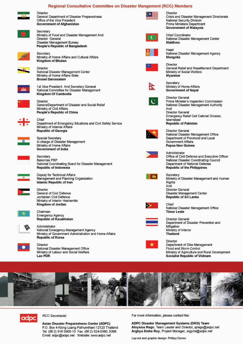
Regional Consultative Committee on Disaster Management (RCC) The Regional Consultative Committee on Disaster Management (RCC) was established at the initiative of the Asian Disaster Preparedness Center (ADPC) in 2000 and comprises of members who are working in key Government positions in the National Disaster Management systems of countries of the Asian region. To date, 26 countries are represented by 30 RCC Members from the Asia and Pacific regions, namely, Afghanistan, Bangladesh Bhutan, Brunei, Cambodia, China, Georgia, India, Indonesia, Iran, Jordan, Kazakhstan, Korea, Lao PDR, Malaysia, Maldives, Mongolia, Myanmar, Nepal, Pakistan, Papua New Guinea, Philippines, Sri Lanka, Thailand, Timor Leste and Vietnam. The Government of the host country of the meeting serves as the Chair of the RCC in the intervening period between two meetings and the Government of the host country of the next meeting serves as the Vice Chair of the RCC. Currently China as the host of RCC 6 is the Chair and Sri Lanka as the host of RCC 7 is the Vice Chair. ADPC serves as the Secretariat of the RCC. RCC Program on Mainstreaming Disaster Risk Reduction into Development Policy, Planning and Implementation in Asia (RCC MDRD) A key priority identified by the RCC is the integration of disaster risk considerations into development planning. To initiate action on this agreed direction, the RCC Program on Mainstreaming Disaster Risk Reduction into Development Policy, Planning and Implementation (MDRD) was launched at the 4th RCC meeting in Bangladesh in March 2004. The RCC 5 adopted the Hanoi RCC 5 statement on Mainstreaming Disaster Risk Reduction into Development in Asian Countries which prioritizes mainstreaming of DRR to be initiated in National development planning process as well as Sectoral development. It identified six priority sectors namely Agriculture, Education, Health, Housing, Urban Planning and Infrastructure and Financial services for mainstreaming of DRR. The program has five components for implementation (as described in the adjacent box); Component 1 involves developing Guidelines and Tools for Mainstreaming of DRR.
RCC MDRD Program Components (Phase I 2004-2007)
• Component 1: Developing Guidelines and Tools for MDRD
• Component 2: Undertaking Priority Implementation Partnerships (PIP) in MDRD in RCC Member Countries
• Component 3: Showcasing good practice on MDRD and Monitoring Progress
• Component 4: Advocacy for Building awareness and Political Support to MDRD
• Component 5: Mobilizing Partnerships for ongoing and sustainable implementation
The Hanoi RCC 5 statement identified the following sub themes within the Urban Planning and Infrastructure to initiate mainstreaming of disaster risk reduction:
• Introducing Disaster Risk Impact Assessments into the construction of new roads and bridges,
• Promoting the use of hazard risk information in land-use planning and zoning programs. History of this Guideline This Guideline is developed by the RCC for guiding the member countries to introduce disaster risk impact assessments into the construction of new roads. For development of this Guideline a technical working group had been set up with experts from Department of Public Works and Highways (DPWH) and National Disaster Coordinating Council (NDCC) in Philippines, Central Road Research Institute (CRRI) in India, Mekong River Commission (MRC), World Wide Fund (WWF) and ADPC. The development of this Guideline had been supported by UN/ISDR and SIDA. The content of the Guideline had gained tremendously from the experience of the Phase I (2006-2007) of the Priority Implementation Partnership (PIP) on the said theme in Philippines, which was implemented by the RCC MDRD secretariat in partnership with NDCC and DPWH with support from UN/ISDR and SIDA. Comments Invited Please send comments to [email protected] and [email protected].
Version 2.1, April 2008
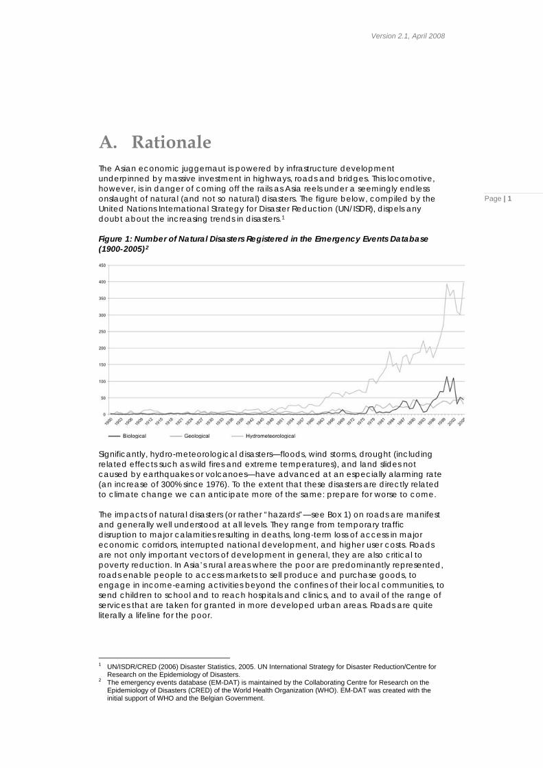
A. Rationale The Asian economic juggernaut is powered by infrastructure development underpinned by massive investment in highways, roads and bridges. This locomotive, however, is in danger of coming off the rails as Asia reels under a seemingly endless onslaught of natural (and not so natural) disasters. The figure below, compiled by the United Nations International Strategy for Disaster Reduction (UN/ISDR), dispels any doubt about the increasing trends in disasters.1
Page | 1
Figure 1: Number of Natural Disasters Registered in the Emergency Events Database (1900-2005)2
Significantly, hydro-meteorological disasters—floods, wind storms, drought (including related effects such as wild fires and extreme temperatures), and land slides not caused by earthquakes or volcanoes—have advanced at an especially alarming rate (an increase of 300% since 1976). To the extent that these disasters are directly related to climate change we can anticipate more of the same: prepare for worse to come. The impacts of natural disasters (or rather “hazards”—see Box 1) on roads are manifest and generally well understood at all levels. They range from temporary traffic disruption to major calamities resulting in deaths, long-term loss of access in major economic corridors, interrupted national development, and higher user costs. Roads are not only important vectors of development in general, they are also critical to poverty reduction. In Asia’s rural areas where the poor are predominantly represented, roads enable people to access markets to sell produce and purchase goods, to engage in income-earning activities beyond the confines of their local communities, to send children to school and to reach hospitals and clinics, and to avail of the range of services that are taken for granted in more developed urban areas. Roads are quite literally a lifeline for the poor.
1 UN/ISDR/CRED (2006) Disaster Statistics, 2005. UN International Strategy for Disaster Reduction/Centre for
Research on the Epidemiology of Disasters. 2 The emergency events database (EM-DAT) is maintained by the Collaborating Centre for Research on the
Epidemiology of Disasters (CRED) of the World Health Organization (WHO). EM-DAT was created with the initial support of WHO and the Belgian Government.
RCC 3.1: Integrating Disaster Risk Assessments as part of Planning process before Construction of New Roads
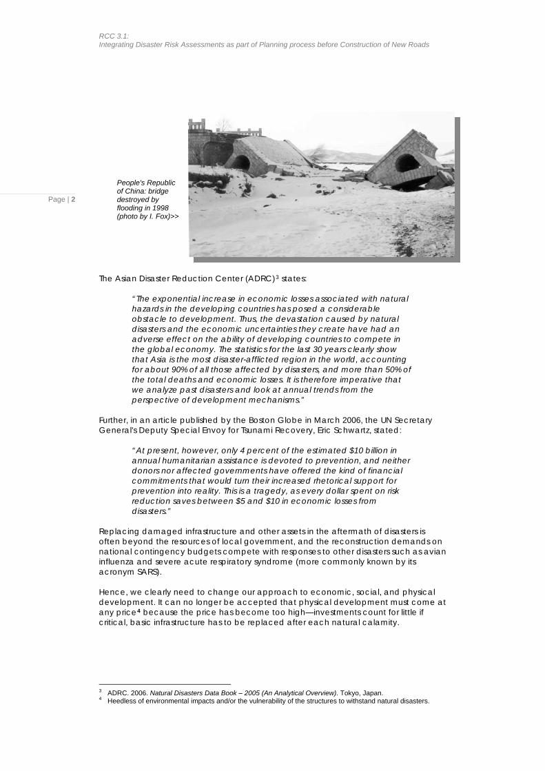
People's Republic of China: bridge destroyed by flooding in 1998 (photo by I. Fox)>>
Page | 2
The Asian Disaster Reduction Center (ADRC)3 states:
“The exponential increase in economic losses associated with natural hazards in the developing countries has posed a considerable obstacle to development. Thus, the devastation caused by natural disasters and the economic uncertainties they create have had an adverse effect on the ability of developing countries to compete in the global economy. The statistics for the last 30 years clearly show that Asia is the most disaster-afflicted region in the world, accounting for about 90% of all those affected by disasters, and more than 50% of the total deaths and economic losses. It is therefore imperative that we analyze past disasters and look at annual trends from the perspective of development mechanisms.”
Further, in an article published by the Boston Globe in March 2006, the UN Secretary General's Deputy Special Envoy for Tsunami Recovery, Eric Schwartz, stated:
“At present, however, only 4 percent of the estimated $10 billion in annual humanitarian assistance is devoted to prevention, and neither donors nor affected governments have offered the kind of financial commitments that would turn their increased rhetorical support for prevention into reality. This is a tragedy, as every dollar spent on risk reduction saves between $5 and $10 in economic losses from disasters.”
Replacing damaged infrastructure and other assets in the aftermath of disasters is often beyond the resources of local government, and the reconstruction demands on national contingency budgets compete with responses to other disasters such as avian influenza and severe acute respiratory syndrome (more commonly known by its acronym SARS). Hence, we clearly need to change our approach to economic, social, and physical development. It can no longer be accepted that physical development must come at any price4 because the price has become too high—investments count for little if critical, basic infrastructure has to be replaced after each natural calamity.
3 ADRC. 2006. Natural Disasters Data Book – 2005 (An Analytical Overview). Tokyo, Japan. 4 Heedless of environmental impacts and/or the vulnerability of the structures to withstand natural disasters.
Version 2.1, April 2008
B. Key Approaches
Page | 3
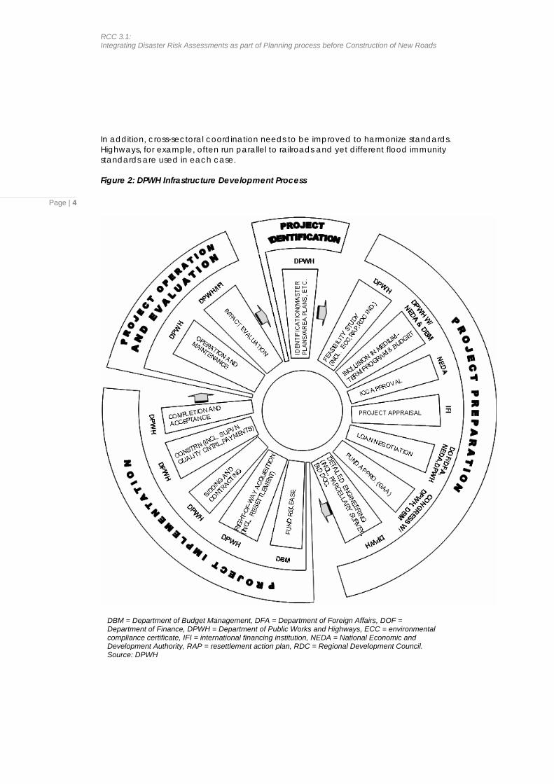
Guidelines in this series are directed specifically at government agencies, as opposed to the majority of guidelines available in the current literature that are directed at development agencies. Key Approach 1: Start at the Right Time The implementation of road projects typically proceeds through phases. For example, the development cycle followed by the Department of Public Works and Highways (DPWH) in the Philippines for infrastructure projects (road, bridge, flood control, water supply) consists of four phases (Figure 2):
• project identification (includes identification, master planning and area planning)
• project preparation (includes feasibility study, project appraisal and detailed design)
• project implementation (includes contracting, construction and acceptance) • project operation and evaluation (includes operation, maintenance and
impact evaluation) The key to successful integration of disaster risk reduction in road and bridge projects lies in the planning phase of the project cycle (project identification and preparation of the feasibility study). Assessing the possible impacts on the project of natural disasters or other hazards at this stage means that the appropriate risk reduction measures can be included in the scope, layout and arrangement of the project’s major components—and that these measures will be allowed for in the cost estimate. If such measures are not included at the planning phase, their inclusion at later stages is unlikely, or at best costly and inconvenient (i.e., possibly requiring a supplementary budget). Attempting to include risk reduction measures at the design stage (after the major elements of the project have been decided and the budget has been allocated) cannot adequately satisfy the need for disaster risk reduction.
Quotation from ProVention’s Tools for Mainstreaming Disaster Risk Reduction: Guidance Notes for Development Organizations “Disaster risk management should be factored into all stages of the project cycle. The initial planning stages of the cycle (programming – identification – appraisal…) are the key entry points at which disaster risk issues can be factored into projects. But disaster risk should not be forgotten during the other stages of financing, implementation and evaluation, and the various activities that take place within them. The different phases in the project cycle are not separate but part of a process of planning, action and reflection that, in an ideal world, feeds lessons from one project into others.” (page 59)
As a general rule, sectoral ministries and their lower-level agencies are reluctant (or unable) to spend money on investigations and surveys during the planning phase (project identification and preparation of the feasibility study). Adjusting standard operating procedures to allow for this may require changing the budgeting process—hence a somewhat painful step initially—to provide budget allocations for surveys and investigations for the planning phase in addition to those allocations linked to supplementary investigations required at the detailed design stage. Nevertheless, that hurdle needs to be overcome to achieve the full benefits of Mainstreaming Disaster Risk Reduction.
RCC 3.1: Integrating Disaster Risk Assessments as part of Planning process before Construction of New Roads
In addition, cross-sectoral coordination needs to be improved to harmonize standards. Highways, for example, often run parallel to railroads and yet different flood immunity standards are used in each case. Figure 2: DPWH Infrastructure Development Process
Page | 4
DBM = Department of Budget Management, DFA = Department of Foreign Affairs, DOF = Department of Finance, DPWH = Department of Public Works and Highways, ECC = environmental compliance certificate, IFI = international financing institution, NEDA = National Economic and Development Authority, RAP = resettlement action plan, RDC = Regional Development Council. Source: DPWH
Version 2.1, April 2008
Page | 5
Contrary to expectations, the consideration of natural hazards and related risks at an early stage of project planning often leads to project cost savings.5 For example, a careful assessment of landslide hazards in mountainous areas can help project planners avoid areas of high landslide risk when selecting the preferred route for a new road, thereby avoiding costly stabilization procedures that would not otherwise be identified until geotechnical investigations are done during the detailed design stage. Similarly, better consideration of the impacts of floods on roads may lead in some cases to cheaper and safer solutions. The first instinct of road designers is to make the road higher than the expected design flood level, thereby ensuring uninterrupted access when floods are in full flush. This creates a dilemma because the road embankment itself creates higher flood levels on the uphill side of the road (which can exacerbate flooding of homes and other property). Such high embankments require costly bridges and culverts with large waterway openings to cope with anticipated floods. High embankments are difficult to maintain in good condition and may fail in a dramatic way, releasing a destructive flood wave, when overtopped by an extreme flood (as will inevitably happen at some future time). In many cases, lower road embankments provide acceptable levels of service. Interruption of traffic caused by floods can be minimized by providing road overflow sections (so-called floodways)6 which allow a thin sheet of water to safely cross the road without stopping the movement of traffic. Floodways are cheaper than bridges and can cope with a wider range of unknowns in hydrologic variables. This is doubly important in catchments for which hydro-meterological data are scarce or nonexistent. Key Approach 2: Build On the Environmental Impact Assessment Process Environmental impact assessments (EIAs) are mandatory in all RCC countries for all major infrastructure projects. Hence, the natural entry point for consideration of the impacts of natural disasters on structures (and of the impact of structures on the natural phenomena themselves—see Box 1) is the EIA process. In many countries, the EIA forms an integral part of the project feasibility report. Hence, building on the EIA process meshes well with Key Approach 1 (starting at the right time). However, as noted in the Priority Implementation Partnership (PIP) conducted in the Philippines on the integration of disaster risk impact assessment into planning phase of road construction (see Box 2), feasibility studies are not normally conducted for roads and structures implemented by provincial and district level agencies, and EIAs are unevenly used for nationally-financed projects—although they are always prepared for projects financed by external agencies (i.e., Asian Development Bank, World Bank, Japan Bank for International Cooperation, etc.).
5 As insurance against future damage due to natural disasters, investments in prevention, preparedness and
mitigation have been shown to have high economic rates of return. Nevertheless, developers are understandably wary of being hit for costly mitigation and prevention measures that may wreak havoc with their economic calculations. Some common sense is therefore needed: it is not reasonable to attempt to mitigate the most extreme events that could occur. For example, it would be unrealistic to design roads in coastal areas in such a way as to make them impervious to the impacts of a major tsunami. Rather, the size of the population at risk coupled with the probability of occurrence of any such event should determine the standard of protection to be provided. ProVention states that “risks emanating from earthquakes and volcanic hazards, with much longer return periods, may be discounted. However, it is important to ensure that such risks are adequately considered from a safety perspective, taking rights to safety and protection into account” (ProVention. 2007).
6 These overflow structures provide a safety margin in terms of hydraulic conveyance capacity, additional to that provided by bridges and culverts. They safely release excess floodwater when the design capacity of the bridges and culverts is exceeded, thereby avoiding the risk of embankment failure due to overtopping in extreme flood events.
RCC 3.1: Integrating Disaster Risk Assessments as part of Planning process before Construction of New Roads
Page | 6
Box 1: The Uniqueness of the Flood Problem
The most frequently occurring disasters in Asia are those related to flooding. For humans, floods are generally considered as natural hazards and their increasing frequency and severity are a major impediment to economic and social development. This depiction of floods as being wholly bad is nevertheless misleading because, in the grand scheme of nature, floods are environmentally benign and wholly good. They are a natural land-forming process. They sustain many aquatic life forms. They are a source of life and richness in the whole river environment. They come with the terrain. Floods and droughts simply mark the extremes of hydrological cycles that are as perennial as the seasons, whether or not their extremes are becoming more unruly as a consequence of climate change. Floods are only a hazard for people who choose to live within the floodplain of a river. They choose to live there because of the natural richness and livelihood opportunities of the land-river environment. This convenience comes at a cost, and that cost is the risk of losing property, livestock, and livelihoods—even the lives of the people who make floodplains their home. As much as 2/3 of the world’s population lives in flood-affected areas and, according to a United Nations University prediction, the number of people living in flood-affected areas will reach 10 billion by 2050. The earliest records of civilization show that human settlements thrived in the fertile floodplains of major rivers. Obviously, the benefits of “living with floods,” even in conditions of relatively high risk, outweigh the disadvantages associated with floods. Earthquakes are also natural events. They differ from floods, however, in one particularly important way—they are readily amenable to engineering solutions. Why do earthquakes of the same magnitude kill fewer people in rich countries than they do in poor countries? Buildings in rich countries have generally been built to better standards. For example, the Kashmir earthquake that killed 73,000 people in Pakistan in 2005 was of a similar magnitude to that which hit Los Angeles in 1994, killing only 60 people. The lesson is clear: adhere to building codes and improve the quality of construction and the risk of serious injury and death from earthquakes will decrease dramatically. Floods (and their river basins) do not respond in the same way. All engineering (structural) solutions applied to a river result in the loss of some part of the natural environment, and all engineering solutions aimed at decreasing the risk of flooding for one part of a river basin increase the risk of flooding for other parts. These counterintuitive outcomes encapsulate the challenge of integrated flood management. In considering floods, we need to differentiate between harmful and beneficial impacts. Hence, in addition to considering the influence of floods on roads and associated infrastructure (i.e., in terms of damage to the road structures), we need to consider the impact of roads on drainage systems and flooding patterns. Roads can easily worsen flooding (by impeding the flow of water across floodplains, for example) and they can have severe negative impacts on ecosystems that sustain fish and other aquatic biota. This duality of function is unique to floods among natural hazards.
Hence, there are compelling arguments for (i) amending environmental regulations if they do not currently mandate EIAs for all projects; (ii) expanding the scope of EIAs to include the impacts of natural disasters on proposed structures; and (ii) including in the EIA process the impacts of the proposed structures on the natural disasters. In all cases adherence to the mandated environmental processes should be strictly followed.
Version 2.1, April 2008
Key Approach 3: Adhere to National Building Codes All countries have national building codes that define the conditions for which structures must be designed (see Appendix 1 for a list of codes applicable to natural hazards in India). These cover (among other things) seismic risks inherent in different parts of the country, rainfall and storm runoff, wind loads, wave heights (in lakes, reservoirs and the sea, as appropriate), and (normally) the provisions to be made for floods and other hydro-metorological events. As noted by the Central Road Research Institute (CRRI),7 India, adherence to these codes is not rigorous in many sectoral agencies.
Page | 7
Quotation from ProVention’s Tools for Mainstreaming Disaster Risk Reduction: Guidance Notes for Development Organizations “The majority of human and direct economic losses from a natural hazard event occur as a direct result of damage to the built environment and/or ineffective early warning and evacuation systems. The negative impact of natural hazards on communities can be limited by taking such hazards into consideration when selecting sites, designing new infrastructure and strengthening existing infrastructure. The exclusion of hazard mitigation measures in development projects is unacceptable in view of the increasing disaster risk in developing countries caused by environmental degradation… and growing urbanisation, with the accompanying rapid increase of poorly built housing, uncontrolled use of land, overstretched services and high population densities. Consequently, development organisations should be accountable for the hazard-proofing measures they include in their construction projects, and for the losses resulting from their non-inclusion.” (page 141)
The consequences of not adhering to national building codes have been shown to be extremely severe. Examples abound, even in the so-called developed countries, of catastrophic failures of road and other infrastructure as a result of non-adherence to codes. Hence, as a relatively easy initial step, sectoral agencies should enforce their internal adherence to building codes. There is simply no excuse for not doing so. Key Approach 4: Partner with NDMOs The common link in many of the RCC countries between the pre-disaster phase (prevention, preparedness and mitigation) and the post-disaster recovery phase (relief, rehabilitation and reconstruction) is the national disaster management organization (NDMO). NDMOs act across all sectors and comprise representatives of relevant ministries, as well as the defence forces, television broadcasters, national offices of the International Committee of the Red Cross, etc. Their mandates cover all types of disaster. NDMOs often have the power to requisition staff and equipment for emergency response. NDMOs represent a natural umbrella agency for the integration across sectors of disaster risk reduction measures in development planning. The RCC4 meeting in Dhaka, 2004 recommended linking advocacy and capacity building in support of MDRR, based on (i) promoting and assisting the involvement of NDMOs and (ii) linking them with the relevant sectoral ministries. This approach worked extremely well in the Philippines where National Disaster Coordinating Council (NDCC) teamed with Department of Public Works and Highways (DPWH) to undertake the PIP (Box 2). Strengthening NDMOs is a prerequisite to their assuming a full and effective role as the umbrella organization for MDRR across multiple sectors in the RCC member countries. 7 In a presentation made at the ADPC workshop on Finalization of the RCC Guideline on Mainstreaming Disaster
Risk Reduction into Infrastructure (Roads) Sector, held in Bangkok on 27-28 July 2007.
RCC 3.1: Integrating Disaster Risk Assessments as part of Planning process before Construction of New Roads
Page | 8
Box 2: Mainstreaming Natural Disaster Risk Reduction into the Planning Process before Construction of New Roads and Bridges in the Philippines Box 2: Mainstreaming Natural Disaster Risk Reduction into the Planning Process before Construction of New Roads and Bridges in the Philippines This priority implementation project, supported by UN/ISDR, was implemented in 2006 by ADPC in partnership with the National Disaster Coordination Council (NDCC) and the Department of Public Works and Highways (DPWH). Its objectives were to:
This priority implementation project, supported by UN/ISDR, was implemented in 2006 by ADPC in partnership with the National Disaster Coordination Council (NDCC) and the Department of Public Works and Highways (DPWH). Its objectives were to:
• review the existing mechanism in carrying out risk assessment before construction of roads and bridges in DPWH
• review the existing mechanism in carrying out risk assessment before construction of roads and bridges in DPWH
• suggest changes that will incorporate disaster risk reduction aspects • suggest changes that will incorporate disaster risk reduction aspects • initiate work towards institutionalizing the proposed changes • initiate work towards institutionalizing the proposed changes
The development of national roads including expressways in the Philippines is the responsibility of DPWH, and local government units (LGUs) are responsible for all other roads. The National Economic Development Authority (NEDA) and other agencies are also involved in the preparation of development plans.
The development of national roads including expressways in the Philippines is the responsibility of DPWH, and local government units (LGUs) are responsible for all other roads. The National Economic Development Authority (NEDA) and other agencies are also involved in the preparation of development plans. Major findings of the PIP are: Major findings of the PIP are:
• DPWH adopts a basic “one size fits all” format for feasibility studies that does not specifically require assessment of disaster risks. During detailed design, disaster risk reduction aspects are incorporated into the project if required.
• DPWH adopts a basic “one size fits all” format for feasibility studies that does not specifically require assessment of disaster risks. During detailed design, disaster risk reduction aspects are incorporated into the project if required.
• National budgets do not provide funds for surveys and investigations at the feasibility study stage, and it is therefore unusual for disaster risk reduction measures to be incorporated at early stages of project preparation.
• National budgets do not provide funds for surveys and investigations at the feasibility study stage, and it is therefore unusual for disaster risk reduction measures to be incorporated at early stages of project preparation.
• DPWH’s externally funded projects are prepared to higher standards, particularly in relation to environmental assessments (where disaster risk aspects are described if required by the particular agency) and resettlement planning.
• DPWH’s externally funded projects are prepared to higher standards, particularly in relation to environmental assessments (where disaster risk aspects are described if required by the particular agency) and resettlement planning.
• There is uneven application of building codes and design standards between national and lower level roads.
• There is uneven application of building codes and design standards between national and lower level roads.
• Information on damage to roads and bridges from natural hazards, prepared by district level offices, uses varying formats and standards of detail.
• Information on damage to roads and bridges from natural hazards, prepared by district level offices, uses varying formats and standards of detail.
• Hydrological data are available for major river basins but these have not uniformly been processed to provide flow/stage relationships for different return periods.
• Hydrological data are available for major river basins but these have not uniformly been processed to provide flow/stage relationships for different return periods.
Major recommendations of the PIP are as follows: Major recommendations of the PIP are as follows:
• DPWH needs to standardize project identification and preparation procedures to eliminate quality discrepancies between nationally- and externally-funded projects, and to pave the way for MDRR in roads and bridges.
• DPWH needs to standardize project identification and preparation procedures to eliminate quality discrepancies between nationally- and externally-funded projects, and to pave the way for MDRR in roads and bridges.
• Feasibility study reports should include assessments of the impacts of disasters.
• Feasibility study reports should include assessments of the impacts of disasters.
• Building codes (based on overseas practice) need to be modified to take account of the specific natural disasters affecting the Philippines.
• Building codes (based on overseas practice) need to be modified to take account of the specific natural disasters affecting the Philippines.
• The existing system for monitoring road and bridge conditions needs to be improved to allow for the recording of damage caused by natural disasters.
• The existing system for monitoring road and bridge conditions needs to be improved to allow for the recording of damage caused by natural disasters.
• Standard formats and reporting standards should be introduced for monitoring.
• Standard formats and reporting standards should be introduced for monitoring.
• Capacity of staff to assess the impacts of natural disasters needs to be increased, particularly at the regional and district levels.
• Capacity of staff to assess the impacts of natural disasters needs to be increased, particularly at the regional and district levels.
Version 2.1, April 2008
Key Approach 5: Prepare Hazard Maps Maps are powerful tools for demonstrating complex spatial and thematic relationships. They are the fundamental building block of land use planning, and the natural starting point for all national, regional and district development planning. In terms of disaster risk management, maps stored in an electronic database (a digital geographic information system or GIS) are unequalled for their ability to integrate numerous layers of information. When data are represented visually, even unskilled map readers can recognize patterns and see where specific hotspots occur and where resources need to be allocated.
Page | 9
Quotation from ProVention’s Tools for Mainstreaming Disaster Risk Reduction: Guidance Notes for Development Organizations “Mapping is a central tool in hazard identification and assessment. Maps can accurately record the location, probable severity and likelihood of occurrence of hazards and display this information clearly and conveniently. They can be to any appropriate scale or level of detail, making them equally useful for national- and local level planning. The type of information recorded varies according to the hazard under investigation. In the case of earthquakes, for instance, it might include geological fault lines, areas of recorded seismic activity and types of soil and bedrock; for floods, topography, geomorphology and previous areas of inundation. Mapping may be based on a range of data sources (e.g., existing maps, remote sensing, surveying). Additional information from photography, field surveys and other sources can be overlaid onto base maps – geographical information systems are making this much easier. Community hazard mapping exercises can also be undertaken. Communities are often knowledgeable about the location and nature of local hazards and their causal factors. Such information is particularly valuable in identifying and appraising localised hazards but community- level outputs can also feed into higher-level mapping and planning. Maps are a good medium for communicating hazards information to decision-makers but often need interpreting – to both non-specialists, who may not be used to seeing information in this form, and educated users, who may be unfamiliar with the particular formats and symbols being used. In all cases the meaning of the data presented should be thoroughly discussed and understood.” (page 23)
Agencies dealing with infrastructure development often have their own map databases. Many countries also have land use, land capability, environmental and climate maps at varying scales for a wide range of themes and timescales. Military maps and aerial photography/satellite images also exist in abundance. It is rare—for security and other reasons—that agencies make these resources available to the general public or even share them among Government agencies by placing them in a central accessible database. That is a terrible waste, but help is at hand in the form of new technological mapping applications. Maps are now available at various scales in the public domain for most of the world. New mapping techniques (and software made freely available within the last 2 years) enable users to download base maps and to add their own thematic layers. As an example of what can be done, the work of researchers from the International Center for Water Hazard and Risk Management (ICHARM) and the University of Yamanashi in Japan is instructive. A real-time flood forecasting model8 has been developed for application in large river basins at any location on the globe. The model uses publicly available data (e.g., elevation, 8 A paper titled Hydrologic Modeling of the Mekong River Basin Using the BTOPMC Model was presented at the
5thAnnual Mekong Flood Forum held by the Mekong River Commission in Ho Chi Minh City, Vietnam on 17-18 May 2007.
RCC 3.1: Integrating Disaster Risk Assessments as part of Planning process before Construction of New Roads
Page | 10
land cover, soil type and texture, vegetation index, radiation, cloud cover, sunshine duration, diurnal temperature range, mean temperature, vapor pressure, wind speed, etc.). Although accuracy of the output nevertheless depends on the quality of available precipitation data, the robustness of the model and the utility of the technique have been amply demonstrated. The work of the Urban Drainage and Flood Control District in Denver, Colorado shows the applicability of modern mapping techniques at a smaller scale.9 Using scalable vector graphics (SVG),10 the District developed web-based applications for flood hazard displays. A multi-layer GIS of the floodplain is stored and maintained by the District in a central database. Users can access the database to view and download high-resolution color photo or topographic maps with overlays of flood hazard information for any part of the district. By specifying latitude and longitude, users see a display with the map re-centered on the address requested. Users can “turn on” the floodplain layer (and other map features) to examine the relative hazard risk of their properties within the floodplain. A zoom feature enables viewing in greater or lesser detail. The ability of such techniques to make detailed hazard information available to the public is one of their greatest attributes. The involvement of the public in assessing hazard risk during the preparatory stages of a project is strongly recommended as a step toward building community level programs for preparedness and mitigation (one of the 4 RCC key action areas, and a particular recommendation on the Hanoi RCC5 statement). Public awareness, and particularly public participation in the planning and design phases, have been shown over and over to result in better projects that are more attuned to the expectations and needs of the affected people (see below the description of the Quang Ngai natural disaster mitigation Project in Vietnam). Affected communities are also able to contribute valuable data relating to past disasters (e.g., severity, extent, location, and date of occurrence). Making results of hazard assessments available to the public through provision of maps, either as hard copies or using web-based methods as above, is also an effective means of putting pressure on official agencies to adhere to EIA and other mandated safeguards.11 Producing hazard maps has never been easier.
9 See http://udfcd.org/publications/pdf/fhn/fhn2006/fhn2006_webFPM.html for the paper titled Web-Based
Floodplain Mapping An Inaugural Success. 10 SVG enables the addition of line drawings that can rescale automatically without loss of image quality. 11 Multi-lateral funding agencies now have disclosure policies which require full consultation with and disclosure to
affected communities of the results of EIAs and all other studies concerning the project.
Version 2.1, April 2008
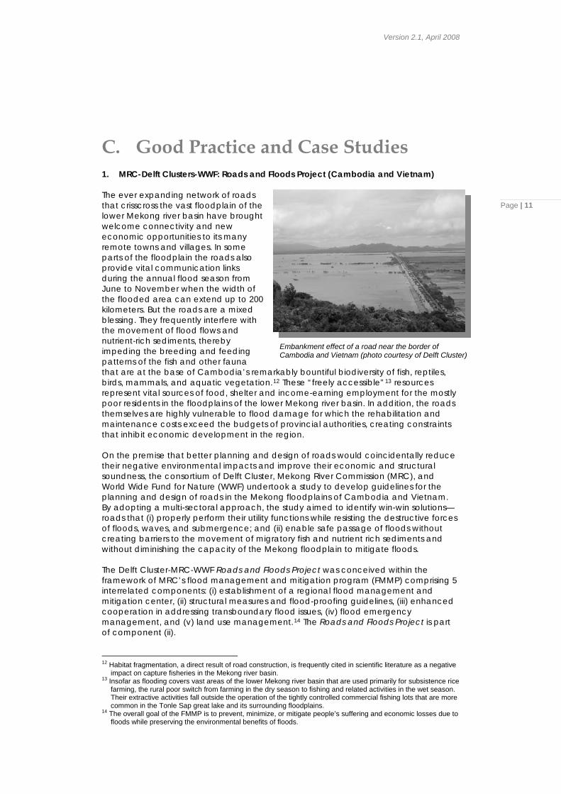
C. Good Practice and Case Studies 1. MRC-Delft Clusters-WWF: Roads and Floods Project (Cambodia and Vietnam) The ever expanding network of roads that crisscross the vast floodplain of the lower Mekong river basin have brought welcome connectivity and new economic opportunities to its many remote towns and villages. In some parts of the floodplain the roads also provide vital communication links during the annual flood season from June to November when the width of the flooded area can extend up to 200 kilometers. But the roads are a mixed blessing. They frequently interfere with the movement of flood flows and nutrient-rich sediments, thereby impeding the breeding and feeding patterns of the fish and other fauna that are at the base of Cambodia’s remarkably bountiful biodiversity of fish, reptiles, birds, mammals, and aquatic vegetation.12 These “freely accessible”13 resources represent vital sources of food, shelter and income-earning employment for the mostly poor residents in the floodplains of the lower Mekong river basin. In addition, the roads themselves are highly vulnerable to flood damage for which the rehabilitation and maintenance costs exceed the budgets of provincial authorities, creating constraints that inhibit economic development in the region.
Page | 11
Embankment effect of a road near the border of Cambodia and Vietnam (photo courtesy of Delft Cluster)
On the premise that better planning and design of roads would coincidentally reduce their negative environmental impacts and improve their economic and structural soundness, the consortium of Delft Cluster, Mekong River Commission (MRC), and World Wide Fund for Nature (WWF) undertook a study to develop guidelines for the planning and design of roads in the Mekong floodplains of Cambodia and Vietnam. By adopting a multi-sectoral approach, the study aimed to identify win-win solutions—roads that (i) properly perform their utility functions while resisting the destructive forces of floods, waves, and submergence; and (ii) enable safe passage of floods without creating barriers to the movement of migratory fish and nutrient rich sediments and without diminishing the capacity of the Mekong floodplain to mitigate floods. The Delft Cluster-MRC-WWF Roads and Floods Project was conceived within the framework of MRC’s flood management and mitigation program (FMMP) comprising 5 interrelated components: (i) establishment of a regional flood management and mitigation center, (ii) structural measures and flood-proofing guidelines, (iii) enhanced cooperation in addressing transboundary flood issues, (iv) flood emergency management, and (v) land use management.14 The Roads and Floods Project is part of component (ii). 12 Habitat fragmentation, a direct result of road construction, is frequently cited in scientific literature as a negative
impact on capture fisheries in the Mekong river basin. 13 Insofar as flooding covers vast areas of the lower Mekong river basin that are used primarily for subsistence rice
farming, the rural poor switch from farming in the dry season to fishing and related activities in the wet season. Their extractive activities fall outside the operation of the tightly controlled commercial fishing lots that are more common in the Tonle Sap great lake and its surrounding floodplains.
14 The overall goal of the FMMP is to prevent, minimize, or mitigate people’s suffering and economic losses due to floods while preserving the environmental benefits of floods.
RCC 3.1: Integrating Disaster Risk Assessments as part of Planning process before Construction of New Roads
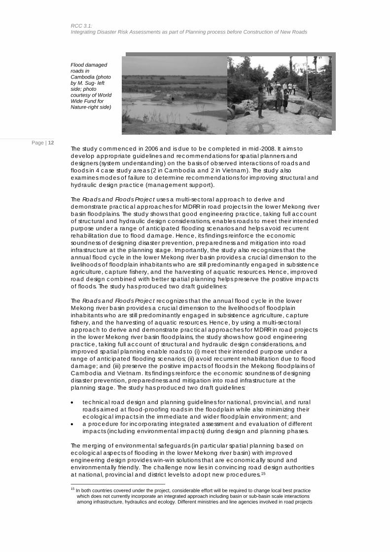
Flood damaged roads in Cambodia (photo by M. Sug- left side; photo courtesy of World Wide Fund for Nature-right side)
Page | 12The study commenced in 2006 and is due to be completed in mid-2008. It aims to develop appropriate guidelines and recommendations for spatial planners and designers (system understanding) on the basis of observed interactions of roads and floods in 4 case study areas (2 in Cambodia and 2 in Vietnam). The study also examines modes of failure to determine recommendations for improving structural and hydraulic design practice (management support). The Roads and Floods Project uses a multi-sectoral approach to derive and demonstrate practical approaches for MDRR in road projects in the lower Mekong river basin floodplains. The study shows that good engineering practice, taking full account of structural and hydraulic design considerations, enables roads to meet their intended purpose under a range of anticipated flooding scenarios and helps avoid recurrent rehabilitation due to flood damage. Hence, its findings reinforce the economic soundness of designing disaster prevention, preparedness and mitigation into road infrastructure at the planning stage. Importantly, the study also recognizes that the annual flood cycle in the lower Mekong river basin provides a crucial dimension to the livelihoods of floodplain inhabitants who are still predominantly engaged in subsistence agriculture, capture fishery, and the harvesting of aquatic resources. Hence, improved road design combined with better spatial planning helps preserve the positive impacts of floods. The study has produced two draft guidelines: The Roads and Floods Project recognizes that the annual flood cycle in the lower Mekong river basin provides a crucial dimension to the livelihoods of floodplain inhabitants who are still predominantly engaged in subsistence agriculture, capture fishery, and the harvesting of aquatic resources. Hence, by using a multi-sectoral approach to derive and demonstrate practical approaches for MDRR in road projects in the lower Mekong river basin floodplains, the study shows how good engineering practice, taking full account of structural and hydraulic design considerations, and improved spatial planning enable roads to (i) meet their intended purpose under a range of anticipated flooding scenarios; (ii) avoid recurrent rehabilitation due to flood damage; and (iii) preserve the positive impacts of floods in the Mekong floodplains of Cambodia and Vietnam. Its findings reinforce the economic soundness of designing disaster prevention, preparedness and mitigation into road infrastructure at the planning stage. The study has produced two draft guidelines: • technical road design and planning guidelines for national, provincial, and rural
roads aimed at flood-proofing roads in the floodplain while also minimizing their ecological impacts in the immediate and wider floodplain environment; and
• a procedure for incorporating integrated assessment and evaluation of different impacts (including environmental impacts) during design and planning phases.
The merging of environmental safeguards (in particular spatial planning based on ecological aspects of flooding in the lower Mekong river basin) with improved engineering design provides win-win solutions that are economically sound and environmentally friendly. The challenge now lies in convincing road design authorities at national, provincial and district levels to adopt new procedures.15 15 In both countries covered under the project, considerable effort will be required to change local best practice
which does not currently incorporate an integrated approach including basin or sub-basin scale interactions among infrastructure, hydraulics and ecology. Different ministries and line agencies involved in road projects
Version 2.1, April 2008
2. Quang Ngai Natural Disaster Mitigation Project, Vietnam The Quang Ngai Natural Disaster Mitigation Project (QNNDMP)16 was conceived in response to strong local demand for better protection from natural hazards following the 1999 floods and typhoons that were particularly disastrous in Vietnam’s Central Region province of Quang Ngai. The project, implemented from 2001-2006, demonstrated a highly successful application of complementary structural, nonstructural and community-based disaster risk management (CBDRM) components. In
addition to CBDRM it incorporated floodplain modeling and planning and construction of infrastructure to demonstrate innovative hazard mitigation solutions.
Page | 13
CBDRM included: • a schools program (to educate
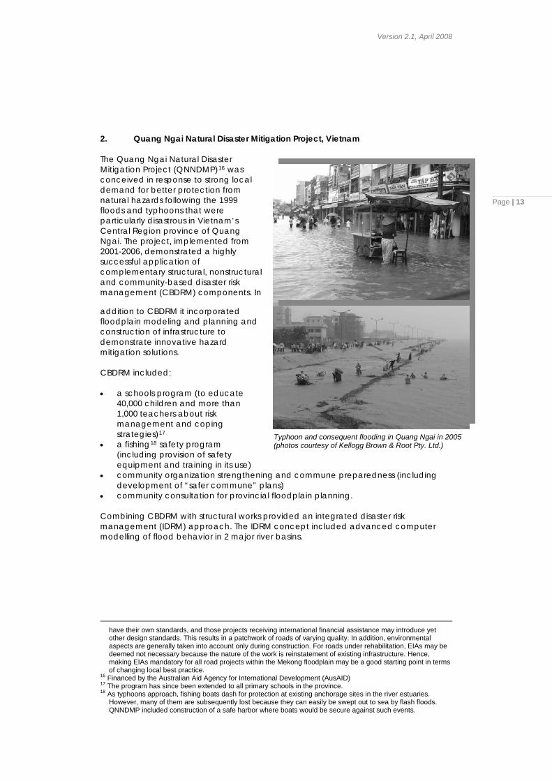
40,000 children and more than 1,000 teachers about risk management and coping strategies)17 Typhoon and consequent flooding in Quang Ngai in 2005
(photos courtesy of Kellogg Brown & Root Pty. Ltd.) • a fishing18 safety program (including provision of safety equipment and training in its use)
• community organization strengthening and commune preparedness (including development of “safer commune” plans)
• community consultation for provincial floodplain planning. Combining CBDRM with structural works provided an integrated disaster risk management (IDRM) approach. The IDRM concept included advanced computer modelling of flood behavior in 2 major river basins.
have their own standards, and those projects receiving international financial assistance may introduce yet other design standards. This results in a patchwork of roads of varying quality. In addition, environmental aspects are generally taken into account only during construction. For roads under rehabilitation, EIAs may be deemed not necessary because the nature of the work is reinstatement of existing infrastructure. Hence, making EIAs mandatory for all road projects within the Mekong floodplain may be a good starting point in terms of changing local best practice.
16 Financed by the Australian Aid Agency for International Development (AusAID) 17 The program has since been extended to all primary schools in the province. 18 As typhoons approach, fishing boats dash for protection at existing anchorage sites in the river estuaries.
However, many of them are subsequently lost because they can easily be swept out to sea by flash floods. QNNDMP included construction of a safe harbor where boats would be secure against such events.
RCC 3.1: Integrating Disaster Risk Assessments as part of Planning process before Construction of New Roads
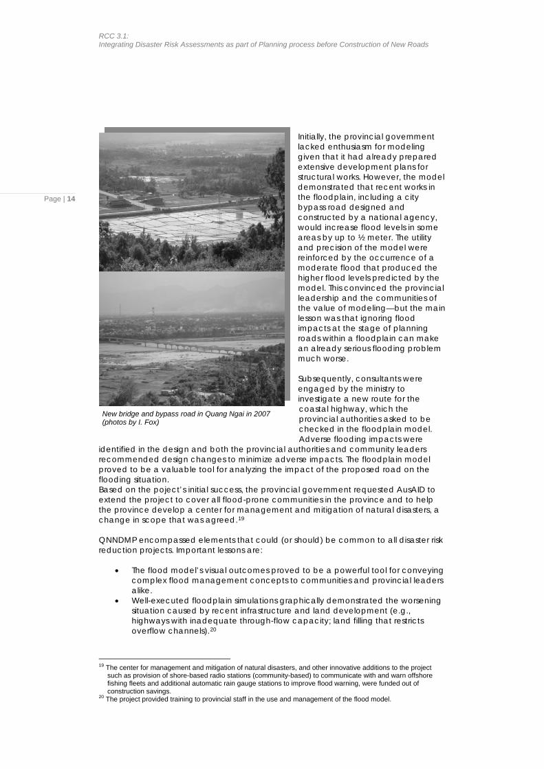
Initially, the provincial government lacked enthusiasm for modeling given that it had already prepared extensive development plans for structural works. However, the model demonstrated that recent works in the floodplain, including a city bypass road designed and constructed by a national agency, would increase flood levels in some areas by up to ½ meter. The utility and precision of the model were reinforced by the occurrence of a moderate flood that produced the higher flood levels predicted by the model. This convinced the provincial leadership and the communities of the value of modeling—but the main lesson was that ignoring flood impacts at the stage of planning roads within a floodplain can make an already serious flooding problem much worse.
Page | 14
Subsequently, consultants were engaged by the ministry to investigate a new route for the coastal highway, which the provincial authorities asked to be checked in the floodplain model. Adverse flooding impacts were
identified in the design and both the provincial authorities and community leaders recommended design changes to minimize adverse impacts. The floodplain model proved to be a valuable tool for analyzing the impact of the proposed road on the flooding situation.
New bridge and bypass road in Quang Ngai in 2007 (photos by I. Fox)
Based on the poject’s initial success, the provincial government requested AusAID to extend the project to cover all flood-prone communities in the province and to help the province develop a center for management and mitigation of natural disasters, a change in scope that was agreed.19 QNNDMP encompassed elements that could (or should) be common to all disaster risk reduction projects. Important lessons are:
• The flood model’s visual outcomes proved to be a powerful tool for conveying complex flood management concepts to communities and provincial leaders alike.
• Well-executed floodplain simulations graphically demonstrated the worsening situation caused by recent infrastructure and land development (e.g., highways with inadequate through-flow capacity; land filling that restricts overflow channels).20
19 The center for management and mitigation of natural disasters, and other innovative additions to the project
such as provision of shore-based radio stations (community-based) to communicate with and warn offshore fishing fleets and additional automatic rain gauge stations to improve flood warning, were funded out of construction savings.
20 The project provided training to provincial staff in the use and management of the flood model.
Version 2.1, April 2008
Page | 15
• Flood modeling convinced the authorities of the value of IDRM, where they had originally been interested only in the structural components of the project, and became the catalyst for inclusion of CBDRM in the planning of all future development in the province.
• Preparing good topographic maps (digital elevation model) of a floodplain can be a daunting task in the absence of reliable data but, once completed and understood by the provincial agencies and local communities, such maps will be used to good effect in development planning.
• Community participation in development of flood management plans was beneficial on multiple fronts and is highly recommended for such projects.
• Successful natural disaster mitigation projects encompass structural, non-structural and community-based elements in their design.
The project needed a substantial period to demonstrate the benefits of IDRM and to change the attitudes of provincial officials to flood risk management and land-use planning. Such a change in attitude did not become apparent until the project had been running for 18 months showing that any change management process needs to be patient and persistent.
RCC 3.1: Integrating Disaster Risk Assessments as part of Planning process before Construction of New Roads
3. Mainstreaming Disaster Risk Reduction into Roads (India) The value of consistent, long-term applied research into natural hazards has been shown through the efforts of the Central Road Research Institute (CRRI), the lead institute for road research in India. CRRI’s research covers floods, earthquakes, landslides, debris slides, snow and rock avalanches and other forms of mass wasting. Working in consultation with the Indian Roads Congress and Ministry of Road Transport and Highways, CRRI has introduced practicable changes in national design standards and codes of practice aimed at making roads and related structures more resilient to the impacts of natural hazards.
Page | 16
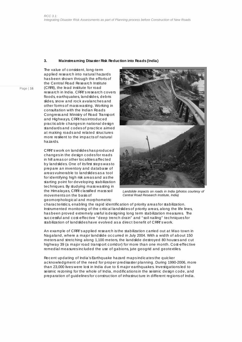
Landslide impacts on roads in India (photos courtesy of Central Road Research Institute, India)
CRRI’s work on landslides has produced changes in the design codes for roads in hill areas or other localities affected by landslides. One of its first steps was to prepare an inventory and database of areas vulnerable to landslides as a tool for identifying high risk areas and as the starting point for developing stabilization techniques. By studying mass wasting in the Himalayas, CRRI classified mass soil movements on the basis of geomorphological and morphometric characteristics, enabling the rapid identification of priority areas for stabilization. Instrumented monitoring of the critical landslides of priority areas, along the life lines, has been proved extremely useful is designing long term stabilization measures. The successful and cost-effective “deep trench drain” and “soil nailing” techniques for stabilization of landslides have evolved as a direct benefit of CRRI’s work. An example of CRRI’s applied research is the stabilization carried out at Mao town in Nagaland, where a major landslide occurred in July 2004. With a width of about 150 meters and stretching along 1,100 meters, the landslide destroyed 80 houses and cut highway 39 (a major road transport corridor) for more than one month. Cost-effective remedial measures included the use of gabions, jute geogrid and geotextiles. Recent updating of India's Earthquake hazard maps indicates the quicker acknowledgment of the need for proper predisaster planning. During 1990-2006, more than 23,000 lives were lost in India due to 6 major earthquakes. Investigations led to seismic rezoning for the whole of India, modifications in the seismic design code, and preparation of guidelines for construction of infrastructure in different regions of India.
Version 2.1, April 2008
Page | 17
D. Detailed Steps for undertaking Priority Implementation Partnerships for integrating disaster risk impact assessment into the planning and design of road construction
The process of integrating disaster risk management into the project cycle (planning, design, implementation and operation and evaluation) is not in itself complicated. The difficulty comes from the reluctance of organizations (and individuals) to change the familiar patterns with which they meet their responsibilities. Organizations and people naturally resist change. It takes a certain courage to adopt new ways of doing things – and also imagination and humility to recognize that we may yet have much to learn about our chosen vocation.
Quotation from ProVention’s Tools for Mainstreaming Disaster Risk Reduction: Guidance Notes for Development Organizations “There is nothing intrinsically difficult about either appraising disaster risks or designing and evaluating risk reduction measures if these tasks are approached thoughtfully and knowledgeably and are adequately resourced” (page 9)
In an ideal world, the head of state would issue an executive order stating that disaster risk reduction measures are, henceforth, part of development policy and will be implemented in all phases of development and all levels of government from national to district. This would create the enabling conditions for ministries/agencies to revise their standard operating procedures to accommodate MDRR requirements, including seeking budget provisions for reorganization and additional staff (if necessary), preparation of implementation of guidelines, training, and pilot implementation. However, it is more realistic to assume that the process will have to be worked through as a series of carefully planned steps, implemented with patience and persistence. In any organization, if certain key persons in the decision-making chain are convinced of the utility and benefits of new procedures, these can be introduced and institutionalized in a relatively short time. It needs no more than one or two champions to get things moving. In the case of roads and bridges, the relevant national organizations would be:
• planning and investment ministry • public works or road and bridge authority • local government • national disaster management organization (NDMO)
1. Phase I for Years 1–3 The following steps are proposed to integrate disaster risk management into the preparatory phase of road and bridge projects, covering project identification, feasibility study and detailed design. The process draws on lessons learned during implementation of the PIP (footnote 6) conducted in the Philippines in 2006-2007, and is premised upon the establishment of a partnership between the NDMO and the public works authority responsible for road and bridge projects. In a subsequent phase (years 3–5), the process would be extended to the project cycle as a whole, covering
RCC 3.1: Integrating Disaster Risk Assessments as part of Planning process before Construction of New Roads
Page | 18
implementation and operation and evaluation in addition to the project preparatory phase. Step 1: Hold preliminary discussions among the relevant stakeholders and organize a workshop under the leadership of the NDMO. The purpose of the workshop would be to engender broad cross-sectoral agreement and commitment among the stakeholder organizations to the principles of PIP on Mainstreaming Disaster Risk Reduction in the road sector. The main outcome of the workshop would be a formal memorandum of understanding (MOU) to (i) set out the objectives, scope and anticipated outcomes of a partnership of the NDMO and the public works or road and bridge authority; and (ii) name the members of a working group for the PIP in the road sector.21 Step 2: Set up an advisory group, chaired by a senior representative of the Government, to oversee and guide the process. Ideally, this representative should be from the planning and investment ministry. The public works or road and bridge authority and NDMO would be represented in the group, along with senior staff of other relevant national level authorities (ministry of environment, ministry of land transport, ministry of rural development, ministry of local government, ministry of urban development, hydrometeorological office, cartography office, research institutes/universities, industry associations, etc.). Step 3: Hold an inaugural meeting of the advisory group to be chaired by the head of the ministry of planning and investment.22 The main outcome of this meeting would be an action plan for the working group, assigning responsibilities for agreed actions and proposed target dates for their achievement. Review of the action plan, analysis of successes and failures, and adjustments of targets in the light of lessons learned would then be the regular business of the advisory group. The inaugural meeting should reinforce the absolute necessity for sectoral agencies to improve their level of cooperation and interaction, and this aspect of the process should be monitored.23 Step 4: The working group would then expand the action plan into discrete programs of activities for its different partners, covering detailed implementation arrangements for each department or office and for each level (national, provincial, district). At this stage the working group should look closely at the budget and staff implications of the proposed new procedures. For example, the inclusion of investigations and surveys in the initial stages of project preparation will add to the costs of feasibility studies and will demand new skills of those charged with carrying them out. Any requirements for amending legislation and ministerial/departmental regulations should also be examined and described (e.g., to make disaster risk assessments part of national development planning, to expand the scope of EIAs and/or instigate more rigorous EIA requirements in nationally-funded projects, to change the way in which budgets for surveys and investigations are decided and allocated, etc.).
21 In the Philippines, such a partnership (between NDCC and DPWH) was created and proved to be effective in
implementing the PIP. A working group comprising senior staff of DPWH and the Office of Civil Defense, National Disaster Coordination Council (OCD-NDCC) was established to guide the process of integration.
22 Invite representatives of multi- and bi-lateral funding agencies to participate as observers in all meetings of the advisory group, having discussed with them beforehand the objectives and scope of the proposed program and its proposed pilot and research projects. Depending on the significance of the funding agencies’ role in national development, they should be involved from the earliest stages of the MDRR process. This would make it easier for funds to be earmarked in support of pilot activities, or for these agencies to envisage deeper programmatic and sector-wide support. The assistance of funding agencies may also be advisable in preparing and promulgating new legislation, regulations and procedures.
23 In most countries, close cooperation among different line agencies occurs quite well at provincial and lower levels. In provincial administrations, line agencies are often housed within one building and are administratively under the authority of the provincial head of state. It Is at the national level where the greatest difficulties occur.
Version 2.1, April 2008
Page | 19
Consideration should also be given to the implications of new procedures mandating consultation with and involvement of communities in hazard risk assessment and in the project planning/design phases in general. Community participation lengthens the period of project preparation and it demands skills that may not be available in road design offices. Step 5: The working group’s recommendations would be submitted to the advisory group for review and approval.24 In particular, the advisory group will be asked to authorize the working group to select and implement one or more pilot projects to put into action the principles and practice of Mainstreaming DRR. Step 6: The working group would select and design pilot projects for Mainstreaming DRR (new road projects, upgrading of existing roads). The process of preparing terms of reference and specifications for the pilot projects would normally require site visits and extensive consultations with provincial authorities and, ideally, community representatives. For all parties, this will be a new approach to business and it should be carefully worked out to ensure buy-in by the relevant players. In selecting pilot projects, the working group should give consideration to studies that could usefully be undertaken by research institutes/universities or industry associations (e.g., associations responsible for amending and approving design codes). These activities and projects would also need to be carefully designed. Step 7: To proceed to implementation of the pilot projects, the working group would need to ensure that budgets are in place for pilot projects and all related activities, obtain approvals (from relevant departments of the public works or road and bridge authority and the NDMO) of terms of reference, and set up the teams (supported by consultants as necessary) to implement the pilot projects. Implementation of the pilot projects should be completed within one or maybe 2 years. 2. Phase II for Years 3–5 In Phase II, it would be appropriate to take the Phase I pilot projects through to implementation where practicable. There are no specific changes to be made in current contracting and construction procedures for that to occur—once the feasibility study and detailed design have been completed for a project, the disaster risk reduction measures will have been included in the project cost and can be implemented and monitored following normal procedures. Particular attention should be given to maintaining (or creating as the case may be) an enabling environment for community participation. It helps greatly if the sectoral agency was open to and supportive of public involvement in the preparation of vulnerability assessments and formulation of appropriate disaster risk reduction measures during project preparation. As noted earlier, this opens the way for building community level programs for preparedness and mitigation and is an effective means of putting pressure on official agencies to adhere to social safeguards and other mandated processes (e.g., EIAs) during implementation. Looking beyond the short-term, sector-specific process of such pilot projects, one sees that Mainstreaming DRR will not be firmly embedded as an integral part of development policy until and unless the Government passes legislation to make it mandatory. Persuading a Government to issue new legislation, particularly where that
24 The advisory group would decide whether any of the recommendations (such as those relating to policy,
legislative or budgetary changes) need to be submitted to higher Government authorities for review and action.
RCC 3.1: Integrating Disaster Risk Assessments as part of Planning process before Construction of New Roads
Page | 20
legislation has cost implications, is not any easy task—and certainly not one to which a firm time-line can be affixed. Hence, this should be seen as a long-term objective. Nevertheless, Mainstreaming DRR measures in development planning can be achieved for a particular sector using steps such as those described above for Phase I. If the sectoral agency’s leadership is strong, the procedures can with time and persistence become part of the organization’s culture. Much depends on the success of the pilot projects in terms of demonstrating the benefits of Mainstreaming DRR. Going beyond the stage of pilot projects to full-scale implementation is, however, a major step and one that needs consistent political and budgetary support. A relatively easy means of Mainstreaming is to include disaster risk reduction considerations into the EIA regulations of individual sectoral agencies so that hazards can be properly dealt with in feasibility studies and detailed designs. Such an adjustment in the EIA process could be achieved without going through the full legislative debate that may be required to make Mainstreaming DRR mandatory across the board in all sectors. The environmental assessment of new projects is a natural entry point for (i) analysis of the vulnerability of people and the built environment to natural disasters and (ii) assessment of possible negative impacts of proposed development on the environment and ecological systems. If partnerships have not already been established with multilateral funding agencies such as World Bank and Asian Development Bank, and/or bilateral agencies such as Australian Aid Agency for International Development (AusAID), Danish International Development Agency (Danida), Japan Bank for International Cooperation (JBIC), etc., then such partnerships should be developed and strengthened during Phase II. These agencies are able to provide long-term program support and funding for individual projects.25 They can also provide expertise in such areas as preparation of draft legislation, capacity building (in the whole range of new activities embodied in Mainstreaming DRR), training in community participatory, and assistance in organizational change management.
E. Existing Guidelines and Toolkits There any a number of existing guidelines and toolkits that have been developed for integration of disaster risk reduction measures in development planning, design, implementation and monitoring. One of the best and most comprehensive has been referred to frequently in this document—it is ProVention’s Tools for Mainstreaming Disaster Risk Reduction: Guidance Notes for Development Organizations. As the title indicates, it is directed at development agencies, whereas the present guideline for MDRR is directed specifically at government agencies. Some of the lead agencies in the field are:
• UN/ISDR • ProVention Consortium • UNDP • Global Facility for Disaster Reduction and Recovery (GFDRR) • TearFund • ActionAid • US Government (Office of Foreign Disaster Assistance)
25 Due to the relatively long lead time for any project or program to enter an aid program and to be approved, the
early establishment of partnerships is always advantageous.
Version 2.1, April 2008
F. Monitoring for Effective Implementation and Compliance
In terms of the recommended procedure for the introduction of MDRR within a particular sector (in this case roads), it is a simple matter to create a monitoring checklist for Phase I (years 1–3) and Phase II (years 3–5) based on the steps described above. Such monitoring, however, does not give a measure of the effectiveness or impact of MDRR—it gives only an indication of the relevant agencies’ adherence to the process.26 To develop a monitoring system that captures the impact of MDRR, one that could be used to give greater weight to the argument for mandating MDRR across sectors, is altogether a more complex matter (see quotation below).
Page | 21 Quotation from ProVention’s Measuring Mitigation: Methodologies for assessing natural hazard risks and the net benefits of mitigation – A scoping study “Natural hazards can pose a wide variety of risks, threatening individual livelihoods, physical structures, macroeconomic performance, environmental resources and so forth. It is difficult to represent this eclectic grouping in a single form of analysis. As such, it would appear better to assess and address risks emanating from natural hazards through other forms of risk assessment – economic, environmental, social and so forth – as well as within broad risk assessments.” (page 19)
This guideline for MDRR in roads and bridges makes the argument that the EIA presents a suitable entry point in the project cycle for introducing MDRR, and that each RCC country can (relatively easily) initiate MDRR within any sector by making changes to the sectoral agency’s EIA regulations. Failing the drafting and promulgation of special legislation to make hazard risk assessments mandatory in development projects, this would appear to be the appropriate starting point.27 However, the mandating of MDRR across the board for all phases of development must be the ultimate goal. This guideline has also made a strong argument in favour of participatory processes in all phases of the project cycle. Not only does participation of the affected persons help ensure greater effectiveness in the conception and design of investment projects, it also enables sectoral agencies to draw on the considerable knowledge that local communities have about the nature, frequency and severity of the natural disasters that affect them (hence, building a data bank from which baseline conditions can more readily be defined). Involvement of local communities during implementation and subsequent monitoring and evaluation (M&E) can also be a powerful incentive for the implementing agency to adhere to its safeguard policies. M&E as currently practised tends to be project-oriented (and therefore likely to miss the long-term impacts of disaster risk reduction measures), and to rely on selective field observations, anecdotal accounts, and interviews with implementing agency staff. It mainly focuses on activities and outputs (e.g., number of persons trained) rather than outcomes (e.g., ability of newly trained staff to apply new approaches).
26 To make the monitoring more impact-oriented, it may be possible to identify quantitative indicators for such
aspects as inclusion of specific cost items for hazard risk assessment and disaster risk reduction measures in the project budget, increased availability of hazard and vulnerability maps in the public domain, ease with which hazard data can be extracted from the NDMO website, extent of cross-sectoral cooperation, and any positive gains or outcomes that can be attributed to the agency’s partnering with NDMO,.
27 ProVention reports that the Carribean Development Bank is currently developing guidelines for natural hazard impact assessment and integration into its EIA process.
RCC 3.1: Integrating Disaster Risk Assessments as part of Planning process before Construction of New Roads
Page | 22
This points to one of the inherent difficulties in monitoring the effectiveness of MDRR—the difficulty of distinguishing avoidable from unavoidable losses due to a particular hazard. The problem stems from what ProVention refers to as “reverse logic”—how to measure the success of an initiative when it is defined by an event that has been prevented from happening? Other problems that plague M&E are:
• general lack of baseline data, • one-off nature of many disaster risk reduction projects, • difficulty of selecting good indicators and ones that can be easily measured, • lack of resources to conduct good quality M&E and to carry it beyond the
period of project implementation, • risk reduction as a development approach does not attract the attention and
support given to post-disaster relief. In spite of the difficulties, there is some cause for optimism. Recently developed techniques for social analysis/vulnerability analysis (that bring together considerations of environmental, social, cultural, institutional, political, and economic factors), reinforced by greater use of existing evaluation tools (environmental assessments, economic analyses using various methodologies to evaluate non-monetary benefits), can overcome to some extent the lack of baseline data and help define appropriate indicators for subsequent M&E. Use of participatory methods is also strengthening the assessment of vulnerability to external shocks such as natural disasters. Persons affected by disasters are well aware of the risks they face and, given the opportunity, can communicate this information. The improvement of project design is a long-overdue measure. Logical frameworks (or design and monitoring frameworks) are often prepared late in the project design phase, do not define objectives in a way that allows for easy verification, give lip service to the risks from natural disasters and the means of addressing them, and give scant regard to the feasibility of the project itself in view of the risks associate with natural disasters. By contrast, ADPC’s Asian Urban Disaster Mitigation Program is frequently cited in the natural disaster literature as having a good logical framework with clear objectives and targets. APPENDIX 1: CODES AND REFERENCES ON NATURAL HAZARDS IN INDIA The following is a list of the design codes for natural hazards in relation to the design and construction of roads and bridges in India. This list is provided as an example of the number and complexity of codes available for natural hazards. All countries have their own codes, adapted to the particular physical conditions and natural hazards of the country concerned. This list does not include the structural, pavement, traffic, safety, drainage and other design codes applicable to the design and construction of roads, highways and bridges. 1. Landslides in Hilly Areas
• Indian Standard (IS: 14680 – 1999) covers the selection of landslide control method to avoid landslides in hill areas.
• Handbook on Landslide Analysis and Correction by CRRI classifies landslides, lists appropriate field and laboratory analyses, and describes slope design and control measures to prevent and correct landslides.
• Mountain Risk Engineering Handbook (published by International Centre
for Integrated Mountain Development, Katmandu Nepal, 1991) provides guidelines for pre-feasibility assessment and feasibility design of mountain
Version 2.1, April 2008
Page | 23
roads, including hazard assessment and mapping. The handbook explains how to prepare engineering geological and geomorphological maps in relation to different types of slope failure. Three methods of hazard mapping are presented.
• IRC: SP:48 – 1998: Hill Road Manual covers all aspects of planning, survey
and investigation, design, construction and maintenance of hill roads, including related structures, roadside amenities, safety, traffic management, ecology and environment, and hazard control measures for landslides, snow avalanches and other forms of mass wasting affecting hill roads.
• SR No.15 – 1996: Landslide Correction Techniques describes the results of
recent research on landslides carried out for Indian conditions.
• IS 14496 (Part 2) – 1998: Guidelines for Preparation of Landslide – Hazard Zonation Maps in Mountainous Terrains Macro-zonation sets out guidelines for preparing landslide hazard maps using the methods given in the code.
• IS 14458 (Part 1) – 1998: Guidelines for Retaining Walls for Hill Area.
• IS 14680:1999: Landslide Control Guidelines.
2. Seismic Design Codes IS 1893 (Part I), 2002, IS 4326, 1993, IS 13827, 1993, IS 13828, 1993, IS 13920, 1993, IS 13935, 1993. Most of these codes are for design, construction and planning of different types of buildings within the different seismic zones of India. The codes relating to bridges are:
• Bridge Rules (1964) – Rules Specifying the Loads for the Design of Super-Structure and Sub-Structure of Bridges and for Assessment of the Strength of Existing Bridges, Ministry of Railways (Railway Board).
• IRC 6 (2000) – Standard Specifications and Code of Practice for Road Bridges – Section II: Loads and Stresses, Indian Roads Congress (IRC), New Delhi.28
• IS 456 (2000) – Indian Standard Code of Practice for Plain and Reinforced Concrete, Bureau of Indian Standards, New Delhi.
• SP 22 (S&T) (1982) – Explanatory Handbook on Codes for Earthquake
Engineering – IS 1893:1975 and IS 4326:1976, Bureau of Indian Standards, New Delhi.
• IS13920 and other appropriate provisions for RCC seismic detailing design.
• BIS (1993): IS 13920 – 1993: Indian Standard Code of Practice for Ductile
Detailing of Reinforced Concrete Structures Subjected to Seismic Forces, Bureau of Indian Standards, New Delhi.
• IRC (1999): IRC 83 – 1999: Standard Specifications and Code of Practice
for Road Bridges, Section IX – Bearings, Indian Roads Congress, New Delhi.
28 After the 2001 Bhuj earthquake in 2002, the IRC released interim provisions that significantly improved the IRC6
(2000) seismic provisions.
RCC 3.1: Integrating Disaster Risk Assessments as part of Planning process before Construction of New Roads
Page | 24
• Tandon, M. (2001) – Earthquake Resistant Design of Bridges, Journal of Indian Roads Congress, Vol. 62, No. 3, pp. 395-451.
• A.S.Arya (1974), Design and construction of girder bridges in seismic areas,
Jai Krishna Volume of Earthquake Engineering. 3. Cyclone Codes
• IS 15498:2004 – Guidelines for improving the cyclonic resistance of low rise houses and other buildings/structures.
• IS 15499:2004 – Guidelines relating to survey of housing and building
typology in cyclone prone areas for assessment of vulnerability.
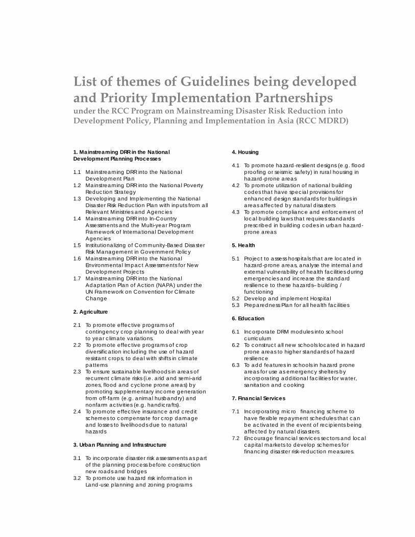
List of themes of Guidelines being developed and Priority Implementation Partnerships under the RCC Program on Mainstreaming Disaster Risk Reduction into Development Policy, Planning and Implementation in Asia (RCC MDRD)
1. Mainstreaming DRR in the National Development Planning Processes 1.1 Mainstreaming DRR into the National
Development Plan 1.2 Mainstreaming DRR into the National Poverty
Reduction Strategy 1.3 Developing and Implementing the National
Disaster Risk Reduction Plan with inputs from all Relevant Ministries and Agencies
1.4 Mainstreaming DRR into In-Country Assessments and the Multi-year Program Framework of International Development Agencies
1.5 Institutionalizing of Community-Based Disaster Risk Management in Government Policy
1.6 Mainstreaming DRR into the National Environmental Impact Assessments for New Development Projects
1.7 Mainstreaming DRR into the National Adaptation Plan of Action (NAPA) under the UN Framework on Convention for Climate Change
2. Agriculture 2.1 To promote effective programs of
contingency crop planning to deal with year to year climate variations.
2.2 To promote effective programs of crop diversification including the use of hazard resistant crops, to deal with shifts in climate patterns
2.3 To ensure sustainable livelihoods in areas of recurrent climate risks (i.e. arid and semi-arid zones, flood and cyclone prone areas) by promoting supplementary income generation from off-farm (e.g. animal husbandry) and nonfarm activities (e.g. handicrafts).
2.4 To promote effective insurance and credit schemes to compensate for crop damage and losses to livelihoods due to natural hazards
3. Urban Planning and Infrastructure 3.1 To incorporate disaster risk assessments as part
of the planning process before construction new roads and bridges
3.2 To promote use hazard risk information in Land-use planning and zoning programs
4. Housing 4.1 To promote hazard-resilient designs (e.g. flood
proofing or seismic safety) in rural housing in hazard-prone areas
4.2 To promote utilization of national building codes that have special provisions for enhanced design standards for buildings in areas affected by natural disasters
4.3 To promote compliance and enforcement of local building laws that requires standards prescribed in building codes in urban hazard-prone areas
5. Health 5.1 Project to assess hospitals that are located in
hazard-prone areas, analyse the internal and external vulnerability of health facilities during emergencies and increase the standard resilience to these hazards– building / functioning
5.2 Develop and implement Hospital 5.3 Preparedness Plan for all health facilities 6. Education 6.1 Incorporate DRM modules into school
curriculum 6.2 To construct all new schools located in hazard
prone areas to higher standards of hazard resilience
6.3 To add features in schools in hazard prone areas for use as emergency shelters by incorporating additional facilities for water, sanitation and cooking
7. Financial Services 7.1 Incorporating micro�financing scheme to
have flexible repayment schedules that can be activated in the event of recipients being affected by natural disasters
7.2 Encourage financial services sectors and local capital markets to develop schemes for financing disaster risk-reduction measures.