Embed Size (px)
Citation preview
Regional climate model simulation of summer precipitation diurnal
cycle over the United States
Xin-Zhong Liang,1 Li Li,1 Aiguo Dai,2 and Kenneth E. Kunkel1
Received 20 July 2004; revised 9 September 2004; accepted 12 November 2004; published 23 December 2004.
[1] MM5-based regional climate model (CMM5)simulations of the diurnal cycle of U.S. summerprecipitation are found to be sensitive to the choice ofcumulus parameterization schemes, whose skills are highlyregime selective. The Grell scheme realistically simulatesthe nocturnal precipitation maxima and their associatedeastward propagation of convective systems over the GreatPlains where the diurnal timing of convection is controlledby the large-scale tropospheric forcing; whereas the Kain-Fritsch scheme is more accurate for the late afternoon peaksin the southeast U.S. where moist convection is governed bythe near-surface forcing. In radar rainfall data and thesimulation with the Grell scheme, another weaker eastwardpropagating diurnal signal is evident from the Appalachiansto the east coast. The result demonstrates the importance ofcumulus schemes and provides a realistic simulation of thecentral U.S. nocturnal precipitation maxima. INDEX
TERMS: 1655 Global Change: Water cycles (1836); 1854
Hydrology: Precipitation (3354). Citation: Liang, X.-Z., L. Li,
A. Dai, and K. E. Kunkel (2004), Regional climate model
simulation of summer precipitation diurnal cycle over the United
States, Geophys. Res. Lett., 31, L24208, doi:10.1029/
2004GL021054.
1. Introduction
[2] The diurnal cycle of precipitation is a crucial part ofthe earth’s hydrology and climate system. It modulatessurface temperature range and is closely associated withthe diurnal cycles of moist convection, thunderstorm activ-ity, cloud formation, and boundary layer development [Daiand Trenberth, 2004]. Collectively they control diurnalvariations of air quality including photochemical produc-tion, aqueous chemistry, wet deposition, and boundary layermixing [Russell and Dennis, 2000; Crutzen and Lawrence,2000].[3] Over the United States, the precipitation diurnal cycle
is characterized by distinct geographic patterns of phase andamplitude variations. Summer precipitation is dominated bynocturnal maxima to the east of the Rockies and over theGreat Plains and late afternoon maxima over the westernand southeastern U.S. [e.g., Wallace, 1975; Riley et al.,1987; Dai et al., 1999]. The nocturnal maxima may becaused by diurnal variations in large-scale vertical motionwith early morning ascending and afternoon descending[Dai et al., 1999] and in the strength of moisture conver-
gence due to the Great Plains low level jet (LLJ) acceler-ation at night [Liang et al., 2001], while surface heatingresults in peak atmospheric instability and thus moistconvection in late afternoon. The diurnal variations acrossthe central U.S. have been linked to coherent propagatingheavy rainfall episodes emanating from the east slope of theContinental Divide to the Midwest [e.g., Carbone et al.,2002].[4] Dai et al. [1999] found that three popular cumulus
schemes [Grell, 1993; Grell et al., 1994; Kuo, 1974; Zhangand McFarlane, 1995] all failed to capture the broad diurnalphase pattern in a regional model, although the Grell andKuo schemes partially reproduced the afternoon-to-earlymorning phase transition from the Rockies to the centralU.S. Davis et al. [2003] showed that two other schemes[Kain and Fritsch, 1993; Betts and Miller, 1993; Janic,1994] are unable to replicate the eastward propagation ofthe central U.S. nocturnal maxima. Knievel et al. [2004]then questioned whether existing cumulus parameterizationscan be tuned, new parameterization approaches are neces-sary, or moist convection must be explicitly resolved inorder to reproduce this feature. On the other hand, Zhang[2003] illustrated that, when the parameterization closure isbased on large-scale tropospheric (convergence/divergenceand radiative heating/cooling) instead of boundary layer(surface sensible and latent heat fluxes) forcing, the Zhang-McFarlane scheme produces significantly improved rainfalldiurnal patterns. Xie et al. [2004] also showed that thesimulation of the precipitation diurnal cycle over the centralU.S. can be improved substantially when the tendency ofconvective available potential energy (CAPE) is consideredin triggering convection in the same scheme. Here we willfurther demonstrate that the Grell and Kain-Fritsch schemesgenerate drastically different and regionally dependentdiurnal patterns, and the combination of the two best depictsobservations.
2. Model Simulations and Observations
[5] Liang et al. [2004] described the CMM5 modelformulation, baseline integration, and precipitation annualcycle performance. They demonstrated that the CMM5,with a horizontal resolution of 30 km, has considerablerainfall downscaling skills, producing more realistic regionaldetails and overall smaller biases than the driving globalreanalysis [Kanamitsu et al., 2002]. A branch CMM5simulation was conducted in parallel to the baseline inte-gration, where the Grell cumulus scheme was replaced bythe Kain-Fritsch scheme with everything else being identi-cal. The branch simulation includes each summer during1982–2002 started from the baseline condition on April 1.The following analysis focuses only on the summer (June,July, and August) months, and refers to the CMM5 simu-
GEOPHYSICAL RESEARCH LETTERS, VOL. 31, L24208, doi:10.1029/2004GL021054, 2004
1Illinois State Water Survey, University of Illinois at Urbana-Champaign, Champaign, Illinois, USA.
2National Center for Atmospheric Research, Boulder, Colorado, USA.
Copyright 2004 by the American Geophysical Union.0094-8276/04/2004GL021054$05.00
L24208 1 of 4
lations using the Grell and Kain-Fritsch schemes as MGRand MKF, respectively.[6] For comparison, we used two observational data sets
of hourly precipitation, referred to as GAU and MUL. TheGAU is derived from quality-controlled rain gauge recordsduring 1982–2002 at about 2500 stations on a 2.5� longi-tude by 2� latitude grid [Higgins et al., 1996]. The MUL isthe National Centers for Environmental Prediction stage-IVmulti-sensor analysis [Fulton et al., 1998], which is theblend of WSR-88D radar estimates and rain gauge measure-ments, available during 1996–2002 on a 4-km grid. Radardata have inherent difficulties in estimating the rainfallamount while gauge data may under-represent the spatialcoverage. The coarse GAU and fine MUL data are mappedonto the CMM5 30-km grid using bilinear interpolation andmass-conservative averaging, respectively.[7] In the following, we focus on the long-term summer
means, averaged over 1982 – 2002 (GAU), 1996 –2002 (MUL), and 1982–2002 (CMM5). Each contains24 hourly-precipitation amounts, which are normalized bya division of the daily mean at individual grids to enhancethe compatibility between observations and simulations[Wallace, 1975; Dai et al., 1999].
3. Results
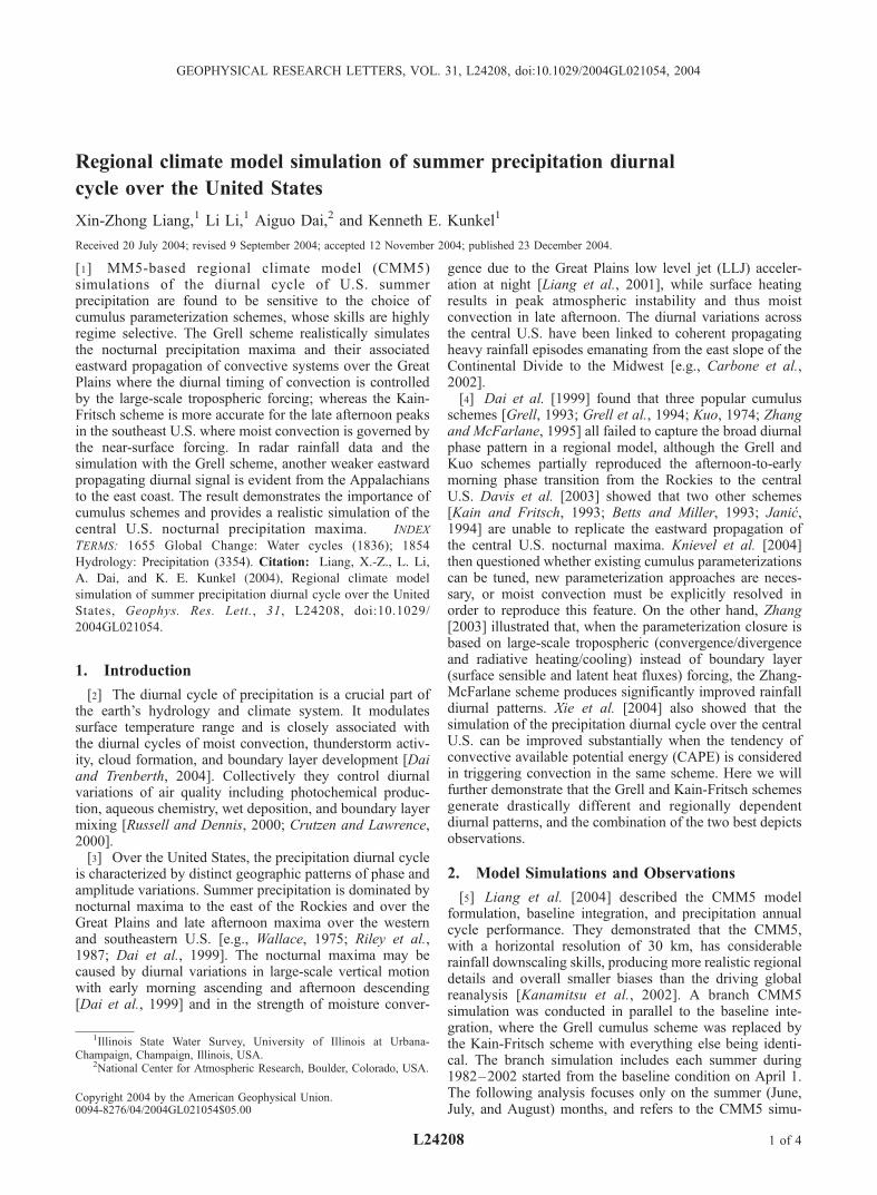
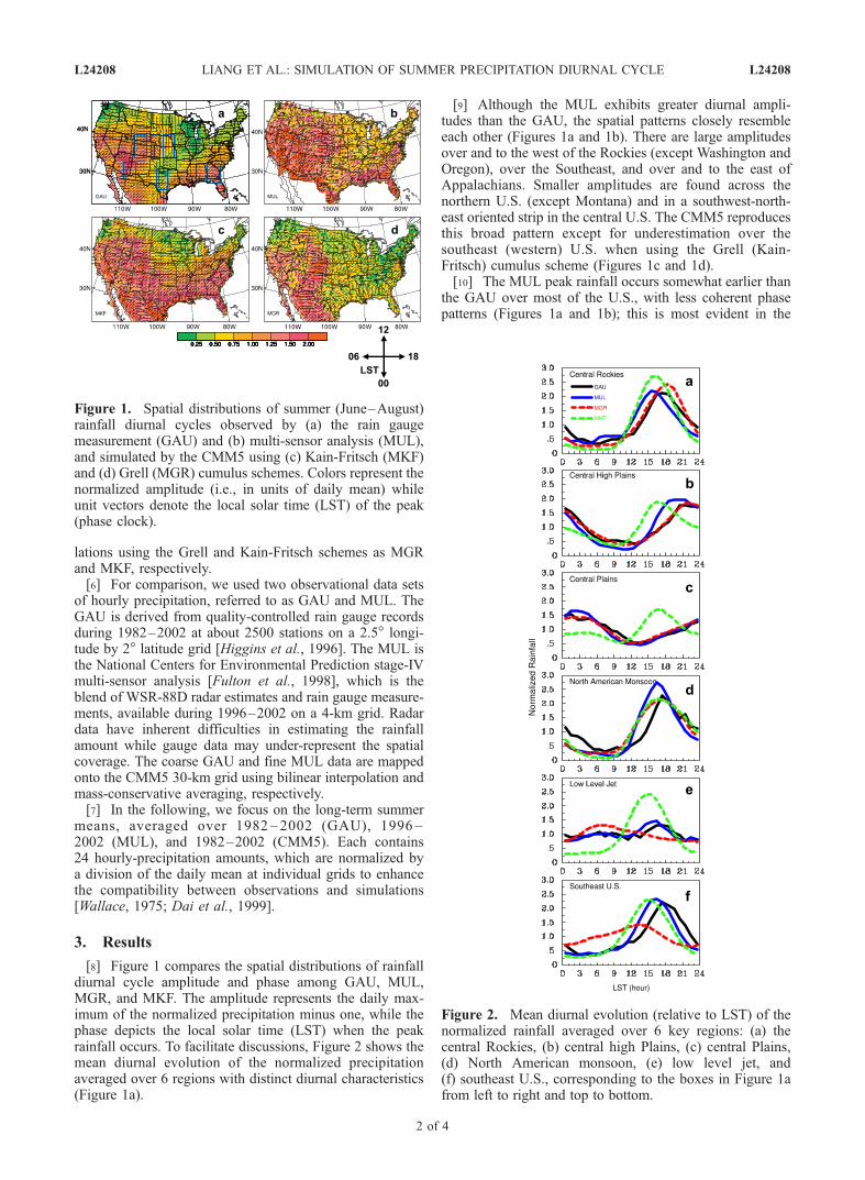
[8] Figure 1 compares the spatial distributions of rainfalldiurnal cycle amplitude and phase among GAU, MUL,MGR, and MKF. The amplitude represents the daily max-imum of the normalized precipitation minus one, while thephase depicts the local solar time (LST) when the peakrainfall occurs. To facilitate discussions, Figure 2 shows themean diurnal evolution of the normalized precipitationaveraged over 6 regions with distinct diurnal characteristics(Figure 1a).
[9] Although the MUL exhibits greater diurnal ampli-tudes than the GAU, the spatial patterns closely resembleeach other (Figures 1a and 1b). There are large amplitudesover and to the west of the Rockies (except Washington andOregon), over the Southeast, and over and to the east ofAppalachians. Smaller amplitudes are found across thenorthern U.S. (except Montana) and in a southwest-north-east oriented strip in the central U.S. The CMM5 reproducesthis broad pattern except for underestimation over thesoutheast (western) U.S. when using the Grell (Kain-Fritsch) cumulus scheme (Figures 1c and 1d).[10] The MUL peak rainfall occurs somewhat earlier than
the GAU over most of the U.S., with less coherent phasepatterns (Figures 1a and 1b); this is most evident in the
Figure 1. Spatial distributions of summer (June–August)rainfall diurnal cycles observed by (a) the rain gaugemeasurement (GAU) and (b) multi-sensor analysis (MUL),and simulated by the CMM5 using (c) Kain-Fritsch (MKF)and (d) Grell (MGR) cumulus schemes. Colors represent thenormalized amplitude (i.e., in units of daily mean) whileunit vectors denote the local solar time (LST) of the peak(phase clock).
Figure 2. Mean diurnal evolution (relative to LST) of thenormalized rainfall averaged over 6 key regions: (a) thecentral Rockies, (b) central high Plains, (c) central Plains,(d) North American monsoon, (e) low level jet, and(f) southeast U.S., corresponding to the boxes in Figure 1afrom left to right and top to bottom.
L24208 LIANG ET AL.: SIMULATION OF SUMMER PRECIPITATION DIURNAL CYCLE L24208
2 of 4
central Rockies, North American monsoon region, andsoutheast U.S. (Figures 2a, 2d, and 2f). Better agreementis evident in the central High Plains, central Plains and LLJregions (Figures 2b, 2c, and 2e). These phase differences areunlikely due to different data periods, since the summerdiurnal cycle pattern is fairly stable from year to year [Dai etal., 1999] and the difference between the GAU 1982–2002and 1996–2002 averages is small. Although no definitiveexplanation is available, some likely causes include delaysin gauge recording of rainfall (biasing GAU toward latertimes) and radar detection of evaporating precipitation andchanging droplet size distribution during storms (bothbiasing MUL toward earlier times) [Fulton et al., 1998;Maddox et al., 2002]. The gauge and radar biases areopposite in sign and both potentially large in the westernU.S. Although their resulting amount of phase shift isdifficult to quantify, these biases are consistent with thefact that the GAU lags the MUL more in the central Rockiesand North American monsoon region than the moist and flatcentral Great Plains and LLJ region. The droplet sizeinduced errors in the radar data could be significant forthe phase shift in the southeast U.S.[11] When compared with the GAU, the MGR realisti-
cally simulates the diurnal amplitude and phase transitionsfrom the central Rockies (18 LST), across the central HighPlains (21 LST), to the central Plains (2 LST) (Figures 1d,2a, 2b, and 2c). In contrast, the MKF fails to capture thephase transitions across these regions, producing a diurnalphase lock with peaks at 16 LST over most of the U.S.(Figure 1c), a feature also of the Betts-Miller-Janic scheme[Davis et al., 2003]. In the Southeast, the MKF produces apeak that is 3 hours earlier than the GAU, while the MGRyields an even earlier and weaker peak (Figure 2f). In theNorth American monsoon region, both schemes reproducethe GAU late afternoon peaks (Figure 2d). The LLJ regionshows a semi-diurnal cycle in both GAU and MUL, withthe primary peak in the late afternoon (�17 LST) and thesecondary one just after sunrise (�7 LST) (Figure 2e). TheCMM5 fails to reproduce this feature, with the Kain-Fritsch
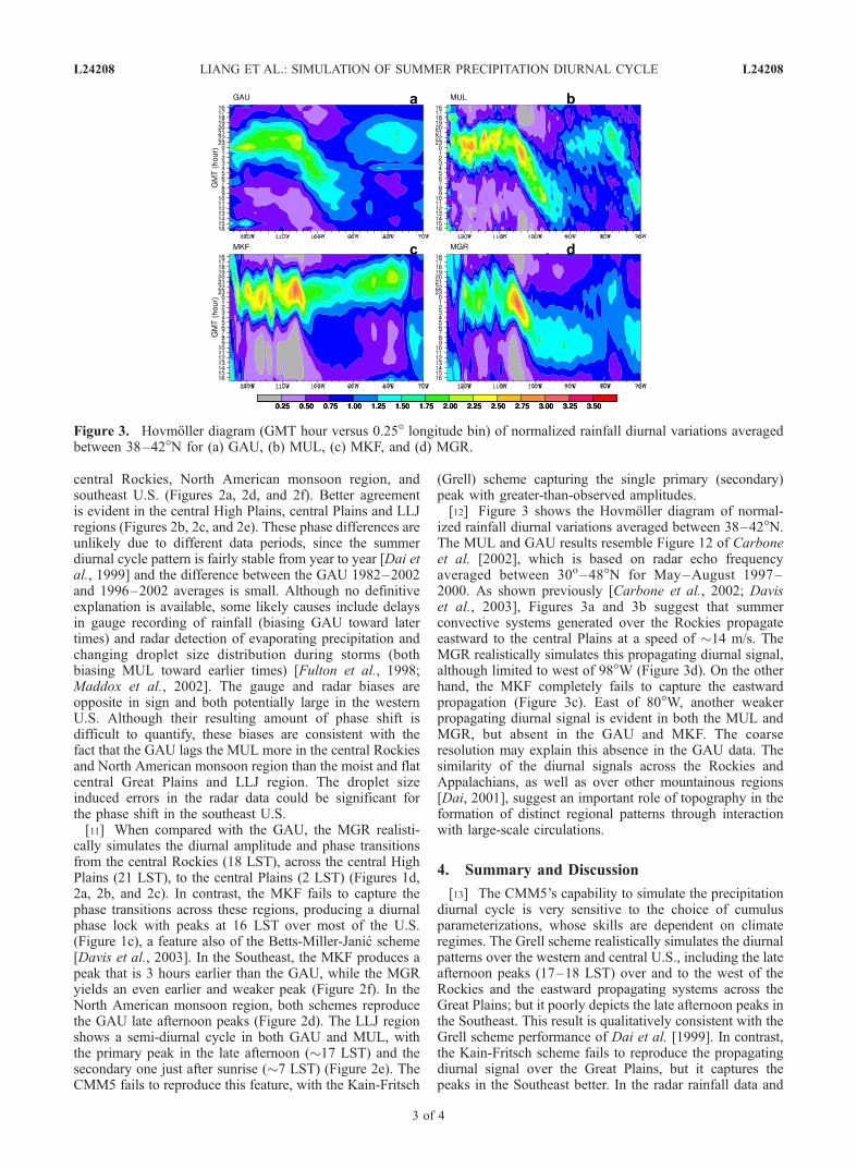
(Grell) scheme capturing the single primary (secondary)peak with greater-than-observed amplitudes.[12] Figure 3 shows the Hovmoller diagram of normal-
ized rainfall diurnal variations averaged between 38–42�N.The MUL and GAU results resemble Figure 12 of Carboneet al. [2002], which is based on radar echo frequencyaveraged between 30o–48�N for May–August 1997–2000. As shown previously [Carbone et al., 2002; Daviset al., 2003], Figures 3a and 3b suggest that summerconvective systems generated over the Rockies propagateeastward to the central Plains at a speed of �14 m/s. TheMGR realistically simulates this propagating diurnal signal,although limited to west of 98�W (Figure 3d). On the otherhand, the MKF completely fails to capture the eastwardpropagation (Figure 3c). East of 80�W, another weakerpropagating diurnal signal is evident in both the MUL andMGR, but absent in the GAU and MKF. The coarseresolution may explain this absence in the GAU data. Thesimilarity of the diurnal signals across the Rockies andAppalachians, as well as over other mountainous regions[Dai, 2001], suggest an important role of topography in theformation of distinct regional patterns through interactionwith large-scale circulations.
4. Summary and Discussion
[13] The CMM5’s capability to simulate the precipitationdiurnal cycle is very sensitive to the choice of cumulusparameterizations, whose skills are dependent on climateregimes. The Grell scheme realistically simulates the diurnalpatterns over the western and central U.S., including the lateafternoon peaks (17–18 LST) over and to the west of theRockies and the eastward propagating systems across theGreat Plains; but it poorly depicts the late afternoon peaks inthe Southeast. This result is qualitatively consistent with theGrell scheme performance of Dai et al. [1999]. In contrast,the Kain-Fritsch scheme fails to reproduce the propagatingdiurnal signal over the Great Plains, but it captures thepeaks in the Southeast better. In the radar rainfall data and
Figure 3. Hovmoller diagram (GMT hour versus 0.25� longitude bin) of normalized rainfall diurnal variations averagedbetween 38–42�N for (a) GAU, (b) MUL, (c) MKF, and (d) MGR.
L24208 LIANG ET AL.: SIMULATION OF SUMMER PRECIPITATION DIURNAL CYCLE L24208
3 of 4
the CCM5 simulation with the Grell scheme, anotherweaker eastward propagating diurnal signal is evident fromthe Appalachians to the east coast.[14] Our results demonstrate the importance of cumulus
parameterization schemes in simulating the diurnal cycle ofsummer continental precipitation, although the role ofsurface heating, the planetary boundary layer and thelarge-scale circulation cannot be ignored, as demonstratedby Dai et al. [1999]. The most common problem in currentU.S. modeling studies is the eastward propagation ofconvective systems and the nocturnal precipitation maximaover the Great Plains [Davis et al., 2003]. Zhang [2003]showed that the Zhang-McFarlane scheme simulates thediurnal cycle over the Great Plains with rainfall peakspredominant at 16 LST or midnight depending on whetherthe parameterization closure is based on large-scale tropo-spheric or boundary layer forcing. Our results agree withthis finding, given that the Grell scheme is very responsiveto large-scale tropospheric forcing whereas the Kain-Fritschscheme is heavily influenced by boundary layer forcing(G. Grell and J. Kain, personal communication, 2004). Assuch, the CMM5’s simulation skill is highly regime selec-tive: the Grell scheme is more realistic over the Great Plainswhere the diurnal timing of convection is influenced by thelarge-scale vertical motion [Dai et al., 1999], whereas theKain-Fritsch scheme works better in the Southeast whereconvection is largely governed by the near-surface forcing.Over the central U.S., there are sufficient moisture andCAPE in the atmosphere for moist convection even duringnight hours [Dai et al., 1999]. The determining factor forthe diurnal timing of convection is not the availability oflocal moisture and CAPE but when and how convection istriggered and instability is modulated. These are subjects offuture studies.
[15] Acknowledgments. We thank George Grell and Jack Kain fornumerous discussions on their cumulus schemes. We appreciate construc-tive comments of Kevin Trenberth, Jason Knievel, Shaocheng Xie and ananonymous reviewer. We acknowledge FSL/NOAA and NCSA/UIUC forthe supercomputing support. The research was partially supported by theU.S. Environmental Protection Agency Award RD-83096301-0 and theChina National 973 Key Project Award G19990435 for Liang and bythe NCAR Water Cycle Across Scales Initiative and NSF Grant ATM-0233568 for Dai. The views expressed are those of the authors and do notnecessarily reflect those of the sponsoring agencies or the Illinois StateWater Survey. The National Center for Atmospheric Research is sponsoredby the U.S. National Science Foundation.
ReferencesBetts, A. K., and M. J. Miller (1993), The Betts-Miller scheme, in TheRepresentation of Cumulus Convection in Numerical Models, Meteorol.Monogr., 46, 107–121.
Carbone, R. E., J. D. Tuttle, D. A. Ahijevych, and S. B. Trier (2002),Inferences of predictability associated with warm season precipitationepisodes, J. Atmos. Sci., 59, 2033–2056.
Crutzen, P. J., and M. G. Lawrence (2000), The impact of precipitationscavenging on the transport of trace gases: A 3-dimensional model sen-sitivity study, J. Atmos. Chem., 37, 81–112.
Dai, A. (2001), Global precipitation and thunderstorm frequencies, part II:Diurnal variations, J. Clim., 14, 1112–1128.
Dai, A., and K. E. Trenberth (2004), The diurnal cycle and its depiction inthe community climate system model, J. Clim., 117, 930–951.
Dai, A., F. Giorgi, and K. E. Trenberth (1999), Observed and model-simulated diurnal cycles of precipitation over the contiguous UnitedStates, J. Geophys. Res., 104, 6377–6402.
Davis, C. A., K. W. Manning, R. E. Carbone, S. B. Trier, and J. D. Tuttle(2003), Coherence of warm-season continental rainfall in numericalweather prediction models, Mon. Weather Rev., 131, 2667–2679.
Fulton, R. A., J. P. Breidenbach, D.-J. Seo, D. A. Miller, and T. O’Bannon(1998), The WSR-88D rainfall algorithm, Weather Forecast., 13, 377–395.
Grell, G. A. (1993), Prognostic evaluation of assumptions used by cumulusparameterizations, Mon. Weather Rev., 121, 764–787.
Grell, G. A., J. Dudhia, and D. R. Stauffer (1994), A description of the fifth-generation Penn State/NCAR Mesoscale Model (MM5), NCAR/TN-398+STR, 122 pp., Natl. Cent. for Atmos. Res., Boulder, Colo.
Higgins, R. W., J. E. Janowiak, and Y.-P. Yao (1996), A gridded hourlyprecipitation database for the United States (1963–1993), NCEP/Clim.Predict. Cent. Atlas 1, 47 pp., U.S. Dep. of Commerce, Washington,D. C.
Janic, Z. I. (1994), The step-mountain Eta coordinate model: Further devel-opments of the convection, viscous sublayer, and turbulence closureschemes, Mon. Weather Rev., 122, 927–945.
Kain, J. S., and J. M. Fritsch (1993), Convective parameterization inmesoscale models: The Kain-Fritsch scheme, in The Representation ofCumulus Convection in Numerical Models, Meteorol. Monogr., 46, 165–170.
Kanamitsu,M.,W. Ebisuzaki, J.Woollen, S.-K. Yang, J. J. Hnilo,M. Fiorino,and G. L. Potter (2002), The NCEP-DOE AMIP-II reanalysis (R-2), Bull.Am. Meteorol. Soc., 83, 1631–1643.
Knievel, J. C., D. A. Ahijevych, and K. W. Manning (2004), Using temporalmodes of rainfall to evaluate the performance of a numerical weatherprediction model, Mon. Weather Rev., 132, 2995–3009.
Kuo, H. L. (1974), Further studies of the parameterization of the influenceof cumulus convection on large-scale flow, J. Atmos. Sci., 31, 1232–1240.
Liang, X.-Z., K. E. Kunkel, and A. N. Samel (2001), Development of aregional climate model for U.S. Midwest applications. Part I: Sensitivityto buffer zone treatment, J. Clim., 14, 4363–4378.
Liang, X.-Z., L. Li, K. E. Kunkel, M. Ting, and J. X. L. Wang (2004),Regional climate model simulation of U.S. precipitation during 1982–2002. Part 1: Annual cycle, J. Clim., 17, 3510–3528.
Maddox, R. A., J. Zhang, J. J. Gourley, and K. W. Howard (2002), Weatherradar coverage over the contiguous United States, Weather Forecast., 17,927–934.
Riley, G. T., M. G. Landin, and L. F. Bosart (1987), The diurnal variabilityof precipitation across the central Rockies and adjacent Great Plains,Mon. Weather Rev., 115, 1161–1172.
Russell, A. G., and R. Dennis (2000), NARSTO critical review of photo-chemical models and modeling, Atmos. Environ., 34, 2283–2324.
Wallace, J. M. (1975), Diurnal variations in precipitation and thunderstormfrequency over the conterminous United States, Mon. Weather Rev., 103,406–419.
Xie, S., M. Zhang, J. S. Boyle, R. T. Cederwall, G. L. Potter, and W. Lin(2004), Impact of a revised convective triggering mechanism on commu-nity atmosphere model, version 2, simulations: Results from short-rangeweather forecasts, J. Geophys. Res., 109, D14102, doi:10.1029/2004JD004692.
Zhang, G. J. (2003), Roles of tropospheric and boundary layer forcing inthe diurnal cycle of convection in the U.S. Southern Great Plains, Geo-phys. Res. Lett., 30, 2281, doi:10.1029/2003GL018554.
Zhang, G. J., and N. A. McFarlane (1995), Sensitivity of climate simula-tions to the parameterization of cumulus convection in the CanadianClimate Centre general circulation model, Atmos. Ocean, 33, 407–446.
�����������������������A. Dai, National Center for Atmospheric Research, Boulder, CO 80301,
USA.K. E. Kunkel, L. Li, and X.-Z. Liang, Illinois State Water Survey,
University of Illinois at Urbana-Champaign, 2204 Griffith Drive,Champaign, IL 61820-7495, USA. ([email protected])
L24208 LIANG ET AL.: SIMULATION OF SUMMER PRECIPITATION DIURNAL CYCLE L24208
4 of 4