Embed Size (px)
Citation preview

UT
POLIDATA ®REGION MAPS
County-Based Regionsand Markets for
UTAH
29 Counties and Portions of
3 MSAs (Metropolitan Statistical Areas from OMB for 1999)
3 GMRs (Metro Groups from Polidata and Gary Maloney for 1999)
1 DMAs (Designated Markets Areas from Nielsen for 2000)
8 ISRs (Internal State Regions from Polidata for 1996)
All Rights Reserved. Copyright © 2002. Polidata ® Demographic and Political Guides. www.polidata.us[49bmb000~psdpbmb1~2I05]
DAVIS011
MILLA027
BEAVE001
WASHI053
IRON_021
GARFI017
KANE_025
SEVIE041
PIUTE031
BOX_E003
JUAB_023
TOOEL045
WEBER057
CARBO007
EMERY015
SAN_J037
SANPE039
WAYNE055
GRAND019
UINTA047
WASAT051
SUMMI043
SALT_035
UTAH_049
CACHE005
MORGA029
DUCHE013
RICH_033
DAGGE009
UTAH, 29 CountiesPolidata County Abbreviations and County FIPS Codes
State FIPS Code is 49
All Rights Reserved. Copyright (c) 2002. Polidata (R) Demographic and Political Guides. www.polidata.usMap: UTRCCLBA.
Counties are the primary political subdivisions of states. Equivalents include Parishes, Boroughs and Independent Cities.

%
!
!
%
Salt Lake City181.7k
Ogden77.2k
Orem84.3k
Provo105.2k
Population Size
8 over 1,000,000 (0)
% over 100,000 (2)
! over 50,000 (2)
UTAH, Selected Places2000 Census of Population and Housing, County Subdivisions
All Rights Reserved. Copyright (c) 2002. Polidata (R) Demographic and Political Guides. www.polidata.usMap: UTRGEOBA.Mrsym
Labels for some placesmay be missing to assistin the clarity of the map.

Election History for UTAH UTAHCounties and Media Markets, 2001-2002 Edition Page CCL.49.1
County Code ListingUTAH, 29 Counties
County or Cy Population County 1990 2000 FIPS PolidataEquivalent Seq Centers Seat Tot. Pop. Tot. Pop. Code CyAbb
BEAVER 1 Beaver Beaver 4,765 6,005 1 BEAVEBOX ELDER 2 Brigham City Brigham City 36,485 42,745 3 BOX_ECACHE 3 Logan Logan 70,183 91,391 5 CACHECARBON 4 Price Price 20,228 20,422 7 CARBODAGGETT 5 West Daggett Manila 690 921 9 DAGGE
DAVIS 6 North Davis Farmington 187,941 238,994 11 DAVISDUCHESNE 7 Roosevelt Duchesne 12,645 14,371 13 DUCHEEMERY 8 Castle Dale Castle Dale 10,332 10,860 15 EMERYGARFIELD 9 Panguitch Panguitch 3,980 4,735 17 GARFIGRAND 10 Moab Moab 6,620 8,485 19 GRAND
IRON 11 Cedar City Parowan 20,789 33,779 21 IRON_JUAB 12 Nephi Nephi 5,817 8,238 23 JUAB_KANE 13 Kanab Kanab 5,169 6,046 25 KANE_MILLARD 14 Delta Fillmore 11,333 12,405 27 MILLAMORGAN 15 Morgan North Morgan 5,528 7,129 29 MORGA
PIUTE 16 Circleville Junciton 1,277 1,435 31 PIUTERICH 17 Randolph-Woodruff Randolph 1,725 1,961 33 RICH_SALT LAKE 18 Salt Lake City Salt Lake City 725,956 898,387 35 SALT_SAN JUAN 19 Blanding Monticello 12,621 14,413 37 SAN_JSANPETE 20 Mantti Mantti 16,259 22,763 39 SANPE
SEVIER 21 Richfield Richfield 15,431 18,842 41 SEVIESUMMIT 22 Park City Coalville 15,518 29,736 43 SUMMITOOELE 23 Tooele-Grantsville Tooele 26,601 40,735 45 TOOELUINTAH 24 Vernal Vernal 22,211 25,224 47 UINTAUTAH 25 Provo-Orem Provo 263,590 368,536 49 UTAH_
WASATCH 26 Heber Heber City 10,089 15,215 51 WASATWASHINGTON 27 St. George St George 48,560 90,354 53 WASHIWAYNE 28 Loa Loa 2,177 2,509 55 WAYNEWEBER 29 Ogden Ogden 158,330 196,533 57 WEBER
UTAH Salt Lake Salt Lake City 1,722,850 2,233,169 49 STATE
POLIDATA (R) Demographic and Political Guides. All Rights Reserved. Copyright (c) 2002. www.polidata.us1. County Equivalents include Independent Cities in MD, MO, NV and VA; Boroughs or Census Areas in AK; Parishes in LA; DC treated as State and County.2. Counties are the primary legal subdivisions of a state. In the New England states they perform few, if any, governmental functions.3. In some states (CT, RI) they are recognized as historic geographic areas for statistical purposes only.4. The FIPS Code is the Federal Information Processing Standards code; 3 digit county code unique within the state, 2 digit state code unique within the nation.5. The Polidata CyAbb is an abbreviation used primarily on our maps. The Cy Seq is a sequential count of county units within the state. Asterisk indicates a break in sequence.[psccl11~49ccla00.ps~2I05]
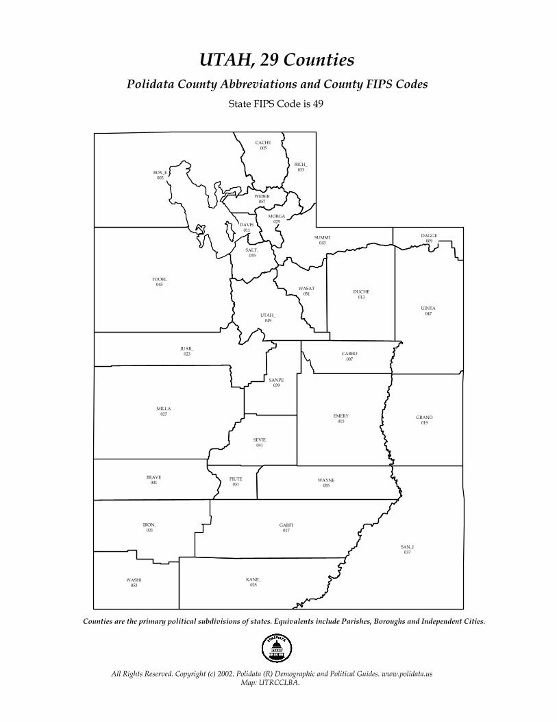
Election History for UTAHUTAHCounties and Media Markets, 2001-2002 EditionPage AS.49.2
Population by Areas/MarketsUTAH
2000 Net % % of % ofSeq Est. Pop. 90-00 Area/Market State Market
UT
2,233,169 29.6 UTAH
MSAs-Metropolitan Statistical Areas (OMB, 1999) 1 6,046 17.0 Flagstaff, AZ - UT MSA 0.3 4.9 2 368,536 39.8 Provo - Orem, UT MSA 16.5 100.0 3 1,333,914 24.4 Salt Lake City - Ogden, UT MSA 59.7 100.0 4 524,673 37.4 Not Assigned to Metro Area (NAM) 23.5 100.0
GMRs-Metro Groups (Polidata/Maloney, 1999) 1 1,333,914 24.4 Salt Lake Metro 59.7 100.0 2 374,582 39.4 Other Metro 16.8 100.0 3 524,673 37.4 Non Metro 23.5 100.0
DMAs-Designated Market Areas (Nielsen, 2000) 1 2,233,169 29.6 Salt Lake City, UT - ID - WY DMA 100.0 94.1
ISRs-Internal State Regions (Polidata, 1996) 1 485,401 25.0 Golden Spike Empire 21.7 100.0 2 93,352 29.8 Bridgerland 4.2 100.0 3 939,122 24.8 Great Salt Lake Country 42.1 100.0 4 413,487 43.0 Mountainland 18.5 100.0 5 40,516 14.0 Dinosaurland 1.8 100.0 6 66,192 26.6 Panoramaland 3.0 100.0 7 140,919 69.3 Color Country 6.3 100.0 8 54,180 8.8 Canyonlands 2.4 100.0
POLIDATA (R) Demographic and Political Guides. All Rights Reserved. Copyright (c) 2002. www.polidata.us1. Areas/Markets are county-based regions comprised of whole counties or equivalents. This includes Parishes (LA), Independent Cities (MD,MO,NV,VA) Boroughs (AK), and Census Areas (AK).2. Metropolitan Statistical Areas (MSAs) reflect federal statistical areas. Some counties are not assigned. MSAs are contiguous yet may cross state borders. NECMAs are used in New England.3. Designated Market Areas (DMAs) reflect television media markets. All counties are assigned to one DMA (a few counties are actually split). DMAs may be noncontiguous and may cross state borders.4. Internal State Regions (ISRs) reflect geographic regions based largely upon travel regions. All counties are assigned. ISRs are contiguous and internal to state borders.5. Metro Groups (GMRs) reflect the size and nature of metropolitan counties. They are based upon work done by Dr. Gary Maloney in 1997 and updated/modified/expanded by Polidata.6. Codes are assigned by either OMB, Nielsen or Polidata to be unique within the nation. Counties unassigned to a metro area are grouped together for consistency purposes.
[49as0000~pspeas21~2I05]

Flagstaff, AZ - UT
Provo - Orem
Salt Lake City - Ogden
Metropolitan Statistical Areas, MSAsGroups of Counties assigned by OMB (1999)
All Rights Reserved. Copyright (c) 2002. Polidata (R) Demographic and Political Guides. www.polidata.usMap: UTRMSABA.
MSAs reflect federal statistical regions. Some counties are not assigned. MSAs are contiguous yet may cross state boundaries.

Non Metro
Salt Lake Metro
Other Metro
Metro Group
Salt Lake Metro
Other Metro
Non Metro
Metro Groups, GMRsGroups of Counties assigned by Polidata and Dr. Gary Maloney (1999)
All Rights Reserved. Copyright (c) 2002. Polidata (R) Demographic and Political Guides. www.polidata.usMap: UTRGMRBA._Name
GMRs reflect the size and nature of metropolitan counties. Shaded counties are Metropolitan.

Salt Lake City
Designated Market Areas, DMAsGroups of Counties assigned by Nielsen Media Research (2000)
All Rights Reserved. Copyright (c) 2002. Polidata (R) Demographic and Political Guides. www.polidata.usMap: UTRDMABA.
DMAs reflect television media markets. Every county is assigned (very few are split). DMAs may be noncontiguous and cross state borders.
Golden Spike Empire
Great Salt Lake Country
Panoramaland
Color Country
Bridgerland
MountainlandDinosaurland
Canyonlands*
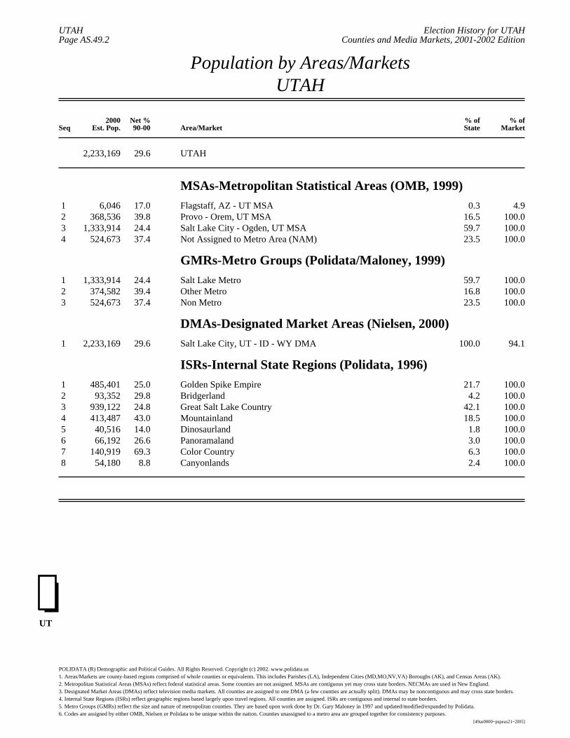
Internal State Regions, ISRsGroups of Counties assigned by Polidata (1996)
All Rights Reserved. Copyright (c) 2002. Polidata (R) Demographic and Political Guides. www.polidata.usMap: UTRISRBA.
ISRs reflect geographic regions based largely upon travel regions. Every county is assigned and regions are internal to state borders.

Election History for NEVADANEVADA (County Locator)Counties and Media MarketsPage CYAM.0.2
County County-Based Area/Market Assignments
NEVADA
CHURCHILL Pony Express Territory ISR; Reno, NV - CA DMA; Not Assigned to Metro Area (NAM); Non Metro GMR.CLARK Las Vegas Territory ISR; Las Vegas, NV DMA; Las Vegas, NV - AZ MSA; Las Vegas Metro GMR.DOUGLAS Reno-Tahoe Territory ISR; Reno, NV - CA DMA; Not Assigned to Metro Area (NAM); Non Metro GMR.ELKO Cowboy Country ISR; Salt Lake City, UT - ID - WY DMA; Not Assigned to Metro Area (NAM); Non Metro GMR.ESMERALDA Pioneer Territory ISR; Reno, NV - CA DMA; Not Assigned to Metro Area (NAM); Non Metro GMR.EUREKA Pony Express Territory ISR; Denver, CO - NE - NV - WY DMA; Not Assigned to Metro Area (NAM); Non Metro GMR.HUMBOLDT Cowboy Country ISR; Reno, NV - CA DMA; Not Assigned to Metro Area (NAM); Non Metro GMR.LANDER Pony Express Territory ISR; Reno, NV - CA DMA; Not Assigned to Metro Area (NAM); Non Metro GMR.LINCOLN Pioneer Territory ISR; Las Vegas, NV DMA; Not Assigned to Metro Area (NAM); Non Metro GMR.LYON Pioneer Territory ISR; Reno, NV - CA DMA; Not Assigned to Metro Area (NAM); Non Metro GMR.MINERAL Pioneer Territory ISR; Reno, NV - CA DMA; Not Assigned to Metro Area (NAM); Non Metro GMR.NYE Pioneer Territory ISR; Las Vegas, NV DMA; Las Vegas, NV - AZ MSA; Las Vegas Metro GMR.PERSHING Cowboy Country ISR; Reno, NV - CA DMA; Not Assigned to Metro Area (NAM); Non Metro GMR.STOREY Reno-Tahoe Territory ISR; Reno, NV - CA DMA; Not Assigned to Metro Area (NAM); Non Metro GMR.WASHOE Reno-Tahoe Territory ISR; Reno, NV - CA DMA; Reno, NV MSA; Other Metro GMR.WHITE PINE Pony Express Territory ISR; Salt Lake City, UT - ID - WY DMA; Not Assigned to Metro Area (NAM); Non Metro GMR.CARSON CITY Reno-Tahoe Territory ISR; Reno, NV - CA DMA; Not Assigned to Metro Area (NAM); Non Metro GMR.
POLIDATA (R) Demographic and Political Guides. All Rights Reserved. Copyright (c) 2002. www.polidata.us1. Areas/Markets are county-based regions comprised of whole counties or equivalents. This includes Parishes, Independent Cities, Boroughs, and Census Areas.2. Metropolitan Statistical Areas (MSAs) reflect federal statistical regions. Some counties are not assigned. MSAs are contiguous yet may cross state borders. NECMAs are used in New England.3. Designated Market Areas (DMAs) reflect television media markets. All counties are assigned. A few counties are actually split. DMAs may be noncontiguous and may cross state borders.4. Internal State Regions (ISRs) reflect geographic regions based largely upon travel regions. All counties are assigned. ISRs are contiguous and internal to state borders.5. Metro Groups (GMRs) reflect the size and nature of metropolitan counties. They are based upon work done by Dr. Gary Maloney in 1997 and updated/modified/expanded by Polidata.6. Codes are assigned by either OMB, Nielsen or Polidata to be unique within the nation. Counties unassigned to a metro area are grouped together for consistency purposes.
[32cyam00~pscyam21~2I05]

THIS PAGE INTENTIONALLY BLANK

''
'
'
'
''
'
'
'''
'
'
'
'
Millard
Grand
Coconino
M h
Clark
Lincoln
Garfield
Washington Kane
San Juan
Iron
Sevier
Beaver Piute Wayne
Emery
San Juan
Dolores
La PlataMontezuma
Ouray
San Miguel
San Ju
Montrose
Mesa
Power
Juab
White Pine
Tooele
Twin FallsCassia
Box Elder
Jerome
Delta
WasatchDuchesne
Sanpete
Utah
Carbon
Uintah
Garfield
Rio Blanco
Uinta
Summit
Salt Lake
Davis
Morgan
Moffat
Sweetwater
Daggett
Franklin
Cache
Weber
Oneida
Bannock
Lincoln
Rich
Bear Lake
I80
I15
I15
I70
I84
I84
I70
I70
I70
I80
I84
I215
I80
I15I15/I84
I86
adiseHenderson
nrise Manor
Farmington
Provo
West JordanSandy
Orem
Salt Lake City
Taylorsville-BennionWest Valley CityMillcreek
Bountiful
Logan
Ogden
Layton
Refer to Gazetteer for profile material
All Rights Reserved. Copyright (c) 2002. Polidata (R) Demographic and Political Guides. www.polidata.usMap: UTROVRBA.Substr(_Id,1,2)
Regional Overview Map
See other maps for census geography