Embed Size (px)
Citation preview

78
2018-2
020 H
unting &
Tra
ppin
g R
egula
tions S
ynopsis
RE
GIO
N 7
B
REGION 7BCheck website
www.gov.bc.ca/hunting for in-season changes prior to your hunt.
78
6-23
6-20
6-19
6-186-17
6-30
6-9
6-8
6-7
6-6
6-4
6-2
6-1
5-9 5-2
5-10
5-125-13
5-15
5-16
Wolverin
e
R
AL
BE
RT
A
N W T Y U K O N
Houston
Smithers
Hazelton
Fort St John
Wonowon
Pink Mountain
Dawson Creek
Chetwynd
TumblerRidge
Mackenzie
FortSt James
PRINCEGEORGE
Vanderhoof
McBride
ValemountQuesnel
Burns Lake
Fort Nelson
WhitesailL
Tahtsa L
KnewstubbL
OOTSA
LAKE
BABINE
LAKE
STUART LAKE
TAKLA
LAKE
WILLISTON
LAKE
François Lake
Trembleur L
Pinchi L
Tchentlo L
Chuchi L
Maxhamish Lake
KotchoL
NilkitkwaL
Deadwood L
MoriceL
Entia
ko R
Endako R
Morice R
BULKLEY
RIVER Zymoetz
R
Babine
R
EUTSUK LAKE
Kispiox R
Skeena R
Sustut
R
Driftwood R
Fox R
Finlay
Ingenika R
Chukachida R
Spatsizi R
Stikine
River River
Kechika
River
Frog
R
Pitman R
Red R
Dall R
River
Rabbit
R
LIARD
RIV
ER
Turnagain
Swannell
R
Polly Cr
Mesilinka R
Osilinka
R
Omenica River
Ospika R
Pesika Cr
Akie R
Kwadacha R
SIKANNI CHIE
F RIV
ER
FINLAY
REACH
REACH
PEACE
REACH
REACH
CANOE
PARSNIP
Toad
River
Gataga
R
Racing R
Dun
edin
R
Tetsa R
Tuchodi R
PROPHET
RIV
ER
Muskwa
R
Tenaka
Cr
Petitot
R
FORT
NE
LSON
RIV
ER
Hay R
Ko
tcho
Fontas
R
R
Co
nvo
y Cr
Beatton
River
Blueberry R
Cam
eron R
River
Halfway Graham
R
PEACE RIVER
Moberly R
Pine
Riv
er
Kiska tinaw
R
Murray
River
Sukunka
R
Parsnip
River
Nation
R
Middle R
Manson
R
Clearwater
Cr
Burnt
R
Redwillow
R
Wapiti
River
McGregor
River
FRASER
RIVER
FRA
SER
RIVER
Bowron
R
Willow
R
Quesnel
R
Goat R
Chilako
R
NECHAKO
R
STUART R
Salmon
R
Crooked R
West
Road
River
Euchiniko R
7-1
7-2
7-3
7-4
7-5
7-6
7-7
7-8
7-9
7-11
7-12
7-13
7-14
7-15
7-16
7-177-18
7-19
7-207-21
7-22
7-23
7-247-25
7-26
7-27 7-28
7-317-32
7-337-34
7-357-36
7-37
7-38
7-39
7-40 7-41 7-42
7-43
7-44
7-45
7-46
7-47
7-48
7-49
7-50
7-51
7-52
7-53
7-54
7-55
7-56
7-57
7-58
7-30
7-29
7-10
OMINECA
PEACE
For information on Wildlife Permits and Commercial Licences, please see page 24.
COMPULSORY INSPECTION CENTRES
Qualified Compulsory Inspectors will provide this service at the locations listed below. Please see the Ministry website at www.gov.bc.ca/hunting or contact the regional office for more information.
CI Locations: Fort St. John, Fort Nelson, Pouce Coupe
Ministry Regional Office, Fort St. John: . . . . . . . . . . . . (250) 787-3411
CONSERVATION OFFICER SERVICE DISTRICT OFFICES
Please call 1-877-952-7277 for recorded information or to make an appoint-ment at any of the following Field Offices: Chetwynd, Dawson Creek, Fort Nelson and Fort St. John
These M.U. boundaries are approximate only. For a more precise definition consult the BC Recreational Atlas, 6th edition.
REPORT ALL POACHERS/
POLLUTERS (RAPP)
See Notice on
page 26 for details
Major Regulation Changes
for 2018-2020
1. Lengthened elk hunting season in MU 7-48
2. Shortening of the any bull moose season in the majority of the Peace Region
3. Increased regional cougar bag limit from 1 to 2
4. Lengthened spring black bear season
5. Revised access restrictions for the Muskwa Kechika
6. Reduced possession limit for sharp-tailed grouse
NOTICE!TO HUNTERS
Region 7B is the traditional territory of Treaty #8 and Kaska First Nations. Members of these First Nations exercise their treaty and aboriginal rights throughout the Peace-Liard and at all times - please be respectful of this activity.
Hunters are encouraged to use all parts of wildlife harvested within the Peace-Liard and to participate in wildlife health and sampling programs. Please refer to Information for Hunters on the wildlife health website (gov.bc.ca/wildlifehealth) to learn more about how you can assist in improving upon current understandings of wildlife health in the Peace-Liard.
PEACE
79
PEACER
EG
ION
7B
2018-2
020 H
untin
g &
Trappin
g R
egula
tions S
yno
psis
BAG LIMITS4Deer: The combined bag limit for deer in Region 7B is two. The bag limit for mule (black-tailed) deer is one. The bag limit for white-tailed deer is two, only one of which may be a buck, and one of which may be antlerless.
4Grouse:The regional daily aggregate bag limit for grouse: blue (dusky), spruce (Franklin), ruffed is 10. The regional daily bag limit for ptarmigan is 10. The regional daily bag limit for sharp tailed grouse is 3. See page 17 for possession limits.
FIREARMS RESTRICTED AREAS
4Please take note of the Highway No Shooting Areas outlined on page 13.4The discharge of firearms is prohibited on the west half of Lot 1323, Peace River District, in which Halfway Elementary School is located. See Map H23.4The discharge of firearms using single projectiles is prohibited within 400 metres (1/4 mile) of either side of:- Road 520 (Canyon Drive) between Hudson’s Hope and the W.A.C. Bennett Dam.- Road 190 (Twelve Mile Road) between Road 520 and Dunlevy Creek.4The discharge of firearms is prohibited between 9:30 a.m. and 3:30 p.m. daily in the Dawson Creek Environmental Demonstration Area. See Map H12.4The discharge of firearms is prohibited within the Bear Mountain Nordic Ski Area. See Map H4.4The discharge of firearms is prohibited on Fort St. John’s sewage lagoons, that is the Northeast 1/4 of Section 19, Township 83, Range 18, West of the 6th Meridian; and Southwest 1/4 of Section 30, Township 83, Range 18, West of the 6th Meridian.4There is no shooting or hunting within 200 metres of the high water mark of Radar Lake in the vicinity of the City of Dawson Creek.4There is no shooting or hunting within Stone Mountain Park within 1 mile (1.6 km) of the Alaska Highway.4The discharge of firearms is prohibited in the Dokie subdivision in the vicinity of Chetwynd (MU 7-22 & 7-31). See Map H8.
ACCESS MANAGEMENT AREAS
4There are a number of restrictions and prohibitions in this region. Note definitions of "Motor Vehicle", "ATV" and "Snowmobile" in Definitions section.
4Information signs may be posted at the points of closure for road and vehicle restrictions. These signs are for the benefit of hunters, but it is the hunters’ responsibil-ity to recognize closures whether a sign is in place or not.
4Symbol Key: Use the following symbols to determine what type of motor vehicle prohibition is in place in the follow-ing regional MUs (see also Site and Access Restrictions section, pages 11-12):
H Motor Vehicle Closed Areas The operation of all motor vehicles is
prohibited year round in these areas unless otherwise indicated.
s Motor Vehicles for Hunting Closed Areas
The operation of all motor vehicles for the purpose of hunting, to trans-port wildlife, to transport equipment, firearms and supplies which are intended for or in support of hunting or to transport hunters to and from the location of wildlife is prohibited in these areas.
u ATVs for Hunting Closed Areas The operation of ATVs (including
motorcycles) for purposes of hunting, or to transport hunters, hunting supplies, wildlife or firearms to or from the location of wildlife is prohibited in these areas.
MUs 7-19, 7-21(southeast portion), 7-31, 7-35, 7-36, 7-43, 7-53, 7-57
H above 1400 metres in elevation. However, the use of snowmobiles (less than 450 kg in weight) is allowed from Nov. 1 to April 30. Onion Lake Trail (MU 7-21) and Talisman et al Murray Road (C-22-E/93-1-15) are open year round. Contact Ministry office in Fort St. John for more information. See Map H7.
MUs 7-21, 7-22
s BP Canada/Ocelot Petroleum West Bullmoose RoadH above the 1524 metre elevation in the Bullmoose Chamberlain Mt. area, except BP Canada/Ocelot Petroleum West Bullmoose Road.
MU 7-36
u east of Aylard Creek and the unnamed creek due north of Aylard Creek that flows into the Graham River, from Aug. 15 to Oct. 31.
MUs 7-36, 7-42, 7-43, 7-50, 7-51, 7-52, 7-54, 7-57
H Muskwa Kechika Access Management Area - Restriction applies to vehicles other than aircraft in portions of these MUs. For information and maps showing specific routes and vehicle restrictions within the Muskwa Kechika, contact Ministry office in Fort St. John and Ministry of Forests and Range offices in Fort Nelson and Dawson Creek. Vehicles 750 kg or greater are no longer permitted on the west corridor. See Map H20.
MU 7-52
H Beyond 400 metres on either side of Jade/Boulder Road (MUs 6-19 & 7-52) from the junction of Jade/Boulder Road and Hwy 37 east to Boulder City Lake, Letain L, Wolverine L and Elephant L, then south along Kutcho Creek to Provencher L and back along the road to its junction with Jade/Boulder Road again. This closure applies between May 1 and Nov. 15.
NOTICE TO HUNTERS
4Individuals are reminded that when they take livestock into the wilderness, they should purchase locally grown feed that is known to be invasive plant-free or use pel-letized and processed feed. The spread of invasive plants is common every year and can be prevented by using local weed-free feed, pelletized and processed feed and checking and cleaning all vehicles to ensure they are weed-free before leaving home. It is suggested to ensure that livestock are fed weed-free feed 2 days prior to departure and including travel time into the wilder-ness. It is recommended to bring and utilize feed bags, buckets or troughs with you while in the wilderness to minimize poten-tial ground disturbance by feeding or salting at temporary cam sites and trail heads. For further information on this matter, please contact your local Ministry of Agriculture or Ministry of Forests, Lands, Natural Resource Operations and Rural Development. Play an important role in invasive species with the Report Invasives BC app.
BC PARKS4Please refer to Site & Access Restrictions section on Page 11 for more information.
“Helping you enjoy the great outdoors”
ATX / STX Modular Spotting ScopesAvailable in 65mm • 85mm 95mm
10120 Alaska Road Fort St. John, BC 250-785-1461 www.backcountryfsj.comFort St. John | 250 787 0356 | mcelhanney.com
HUNTING MAPS AVAILABLE FORNORTHERN BRITISH COLUMBIA
Geomatics Engineering

80
2018-2
020 H
unting &
Tra
ppin
g R
egula
tions S
ynopsis
RE
GIO
N 7
B
PEACE GENERAL OPEN SEASONS
SPECIES MANAGEMENT UNIT CLASS SEASON DATES BAG LIMIT
MULE DEER (Black-tailed) 7-19, 7-36, 7-42, 7-43*, 7-48 to 7-52, 7-57, 7-58 s4 Point Bucks Sept 10 - Oct 5 1
7-20 to 7-22, 7-31 to 7-35, 7-43** to 7-47, 7-54 s4 Point Bucks Nov 1 - Nov 30 1Bow Only Season 7-20, 7-21, 7-32 to 7-35, 7-44 to 7-47 Bucks Sept 1 - Sept 30 1Bag limit for mule deer bucks is one. * Restricted to western portion of MU 7-43 See Map H21. ** Restricted to eastern portion of MU 7-43 See Map H22.s See Definitions Section: Mule (Black-tailed Deer). The antlers must accompany the species licence.
WHITE-TAILED DEER 7-19 to 7-22, 7-31 to 7-36, 7-42 to 7-50, 7-54 to 7-58 Bucks Sept 10 - Nov 30 17-20*, 7-21*, 7-32, 7-33, 7-34, 7-35*, 7-45*, 7-46* Antlerless Oct 10 - Oct 31 1
Youth Only SeasonH 7-20*, 7-21*, 7-32, 7-33, 7-34, 7-35*, 7-45*, 7-46* Either Sex Nov 1 - Nov 30 1
Youth Only SeasonH 7-19 to 7-22, 7-31 to 7-36, 7-42 to 7-50, 7-54 to 7-58 Bucks Sept 1 - Sept 9 1Bow Only Season 7-19 to 7-22, 7-31 to 7-36, 7-42 to 7-50, 7-54 to 7-58 Bucks Sept 1 - Sept 9 1
H Restricted to hunters under the age of 18. * Restricted to portions of MUs 7-20, 7-21, 7-35, 7-45 and 7-46. See Map H11
MOOSE 7-21B, 7-22, 7-31B Bulls Aug 15 - Aug 31 1
7-19, 7-20, 7-21A, 7-31A, 7-32 to 7-36, 7-42 to 7-58 s Bulls Aug 23 - Aug 31 1
7-19, 7-21B, 7-22, 7-31, 7-36, 7-42 to 7-58 s HBulls Sept 1 - Oct 31 1
7-20, 7-21A, 7-32 to 7-35 HBulls Sept 1 - Sept 30 1
7-20, 7-21A, 7-32 to 7-35 HBulls Oct 16 - Oct 31 1Bow Only Season 7-20, 7-21A, 7-32 to 7-35 HBulls Oct 1 - Oct 15 1Moose hunting restrictions within portions of MUs 7-31 and 7-32. See Map H9. For Zones A and B of 7-21 see Map H4B, for Zones A and B of 7-31 see Map H4AH Open only for bull moose: (a) having no more than two points (tines) on one antler ("Spike-fork bull moose"), (b) having antlers with at least three points (tines) on one brow palm (“Tripalm bull moose") or (c) having at least one antler with a minimum of 10 points (tines), including the brow palm. See Definitions section: Moose. The antlers must accompany the species licence. s Compulsory Inspection required of moose taken in portion of MU 7-52 accessible from Region 6. See Map F25 (page 69). ELK 7-42HH, 7-57 s6 Point Bulls Aug 15 - Oct 31 1
7-42H, 7-49, 7-50 s3 Point Bulls Aug 15 - Sept 9 1
7-42H, 7-48, 7-49, 7-50 s6 Point Bulls Sept 10 - Oct 31 1
7-51 to 7-54 s6 Point Bulls Sept 5 - Sept 15 1
7-19, 7-20+, 7-21+, 7-22, 7-31, 7-36, 7-43**, 7-46+ s6 Point Bulls Sept 1 - Oct 31 1
7-20*, 7-21*, 7-32 to 7-35, 7-43***, 7-44, 7-45, 7-46*, 7-58 s3 Point Bulls Sept 1 - Oct 31 1
7-20*, 7-21*, 7-32 to 7-35, 7-43***, 7-44, 7-45, 7-46*, 7-58 Antlerless Sept 15 - Oct 31 1Bow Only Season 7-50 s3 Point Bulls Sept 10 - Oct 31 1
H Restricted to northern portion of MU 7-42, see Map H18 * Restricted to portions of MUs 7-20, 7-21, and 7-46. See Map H11HH Restricted to southern portion of MU 7-42, see Map H19 ** Restricted to western portion of MU 7-43 See Map H21.+ These MUs only include those portions of MUs 7-20, 7-21, and 7-46 located *** Restricted to eastern portion of MU 7-43 See Map H22. outside the shaded portion of the MU. See Map H11. s See Definitions section: Elk. The antlers must accompany the species licence.
BIGHORN MOUNTAIN SHEEP 7-19 Full Curl Bighorn Rams Aug 15 - Sept 30 1Compulsory Inspection required.THINHORN MOUNTAIN SHEEP 7-36, 7-42, 7-43, 7-50 to 7-52, 7-54, 7-57 Full Curl Thinhorn Rams Aug 1 - Oct 15 1See Map H27. Compulsory Inspection requiredMOUNTAIN GOAT s7-36, 7-42, 7-43, 7-50, 7-51, 7-52, 7-54, 7-57 Aug 25 - Oct 15 1
sSee regional maps H17 and H24 to H28 inclusive. Mountain goats are sensitive to harvest. Hunters are requested to select male mountain goat. Compulsory Inspection required.CARIBOU 7-42, 7-50 to 7-54, s 7-57 H5 Point Bulls Aug 15 - Sept 30 1Bow Only Season 7-58 H5 Point Bulls Sept 1 - Sept 30 1
s Restricted to a portion of MU 7-57. See Map H29.
H See Definitions section: Caribou. The antlers must accompany the species licence. Compulsory Inspection required.BLACK BEAR 7-19 to 7-22, 7-31 to 7-36, 7-42 to 7-58 Aug 15 - Nov 15 2
7-19 to 7-22, 7-31 to 7-36, 7-42 to 7-58 Apr 1 - June 30 2WOLF 7-19 to 7-22, 7-31 to 7-36, 7-42 to 7-58 tAug 1 - Mar 31 3s
7-19 to 7-22, 7-31 to 7-36, 7-42 to 7-58 tApr 1 - June 15 3s
tNo closed season below 1100 m elevation. s No bag limit for wolves is being considered, check www.gov.bc.ca/hunting for news prior to your hunt.COUGAR 7-19 to 7-22, 7-31 to 7-36, 7-42 to 7-58 Sept 10 - Mar 31 2Hunters may not hunt a cougar kitten or any cougar in its company. See Definitions section: Cougar kitten. Compulsory Inspection required.COYOTE 7-19 to 7-22, 7-31 to 7-36, 7-42 to 7-58 tSept 1 - Mar 31 NBL
tNo closed season below 1100 m elevation. WOLVERINE 7-19 to 7-22, 7-31 to 7-36, 7-42, 7-43, 7-47 to 7-58 Oct 15 - Jan 15 1LYNX 7-19 to 7-22, 7-31 to 7-36, 7-42 to 7-58 Nov 15 - Feb 15 1SNOWSHOE HARE 7-19 to 7-22, 7-31 to 7-36, 7-42 to 7-58 Aug 1 - Apr 30 10 (daily)DUSKY (Blue) GROUSE 7-21, 7-22, 7-31, 7-36, 7-42, 7-43, 7-50 to 7-52, 7-54, 7-57, 7-58 Sept 1 - Nov 15 10 (30)The daily aggregate bag limit for Dusky, Spruce and Ruffed grouse combined is 10; the aggregate possession limit for Dusky, Spruce and Ruffed grouse combined is 30.

81
RE
GIO
N 7
B2018-2
020 H
untin
g &
Trappin
g R
egula
tions S
ynopsis
PEACE GENERAL OPEN SEASONS
SPECIES MANAGEMENT UNIT CLASS SEASON DATES BAG LIMIT
SPRUCE and RUFFED GROUSE 7-19 to 7-22, 7-31 to 7-36, 7-42 to 7-58 Sept 1 - Nov 15 10 (30)The daily aggregate bag limit for Dusky, Spruce and Ruffed grouse combined is 10; the aggregate possession limit for Dusky, Spruce and Ruffed grouse combined is 30.
SHARP-TAILED GROUSE 7-20 to 7-22, 7-32 to 7-35, 7-44 to 7-49, 7-52 to 7-56, 7-58 Sept 1 - Nov 15 3 (6)PTARMIGAN 7-19, 7-21,7-22, 7-31, 7-36, 7-42,7-43, 7-50 to 7-55, 7-57 Aug 15 - Feb 28 10 (30)RAVEN s7-20, 7-21, 7-32 to 7-35, 7-45, 7-46 No Closed Season 5
s Restricted to private land (with permission of the landowner) COOTS,COMMON SNIPE 7-19 to 7-22, 7-31 to 7-36, 7-42 to 7-58 Sept 3 - Nov 30 10 each (30 each)See Map H14DUCKS 7-19 to 7-22, 7-31 to 7-36, 7-42 to 7-58 Sept 3 - Nov 30 8 (24)See Map H14. Restricted daily bag limits of 4 Pintails, 4 Canvasbacks, 2 Goldeneye and 2 Harlequins are in effect - see page 17.GEESE: SNOW & ROSS’S 7-19 to 7-22, 7-31 to 7-36, 7-42 to 7-58 Sept 3 - Nov 30 5 (15)GEESE: WHITE-FRONTED 7-19 to 7-22, 7-31 to 7-36, 7-42 to 7-58 Sept 3 - Nov 30 5 (15)GEESE: CANADA & CACKLING 7-19 to 7-22, 7-31 to 7-36, 7-42 to 7-58 Sept 3 - Nov 30 10 (30)Geese: See map H14
WATERFOWLER HERITAGE DAYS: (Waterfowler Heritage Days are restricted to hunters under the age of 18. See Waterfowler Heritage Days section.)
DUCKS and GEESE 7-19 to 7-22, 7-31 to 7-36, 7-42 to 7-58 Sept 1 - Sept 2 H
H Daily bag and possession limits are same as general open seasons described above. See page 17 for more details.
Fly-in to hunt from Fort Nelson and Muncho Lake to
Kluachesi, Tuchodi, Kwadacha and Northern Rocky
Mountain
Trench Areas
Outpost hunting
cabins are available on three remote mountain lakes.
LIARD TOURS LTD.
Toll Free: 1-800-663-5269
Phone: (250) 776-3481
Email: [email protected]
Website: www.bcresidenthunting.com
NORTHERN BRITISH COLUMBIA
Floatplane charters for
BC Resident Hunters since 1981
M
oon
ies C
r.
Mt. Gorman
Mt.Minnes
Mt.Hanington
Jarvis
Lakes
Kak
wa
Riv
er
Cecilia
Cre
ek
ALBERTA
B.C.
Buchanun Cr.
Idol Cr.
Idol Cr.
Intersection Mtn.
He
igh
t of L
an
d
KAKWA
PARK
Kakwa (RA)
31 32 33
26
23
14
2 6 5 4 3 2 1
25 30 29 28 27
22
21
34
31
30
19
7
6
31
27
23
15 14
10 11
DawsonCreek
Township
77
Township
21
KiskatinawRiver
Tate Cr.
Tupper Cr.
Little Tupper Cr.
Tu
pp
er
Cre
ek
Sw
an
L.
ALB
ER
TA
B.C
.
Tomslake
to Dawson
Creek
Fence
Community
Pasture
2
Tupper
M.U.7–20 2
Tp. 77 R.15 W.6
19 20 21
18
25
22
15
10 11 12
13
3 2 1
23 24
14
17 16
Creek
South
Dawson Cr.
Radar
Lake Rd.
Radar
Lake Rd.
Airfield
Tp. 77
R.16
W.6
Bissette Cr.
PouceCoupé
Pouce c
ou
pé
R
.
M.U.
7–20
No Shooting Area
Map H1 Kakwa Park and Recreation Area No Hunting Area (MU 7-19).
Map H2 Bear Mountain No Hunting Area (MU 7-20), from June 1 to Oct 15.
Map H3 One Island Lake Firearms Using Shot Only Area (MU 7-20) from June 1 to Oct 15.
Map H4 Bear Mountain Nordic Ski Area - No Shooting Area (MU 7-20)
7-21
7-20
7-23
7-22
7-19
7-32
7-18
7-33
ine RiverChetwynd
Pine River
Mu
rray Rive
r
Hwy 29
Hw
y 5
2
Hw
y 52Zone B of 7-21
Zone A of 7-21
7-31
7-22
7-30
7-29
7-32
7-36
7-357-37
7-28
7-23
k
r
R
Pe
acc
D
l l i s t o nL
ak e
)
( W i l
Dinosaur
Lake
ee
29E AP C E
R E A C H
Pe
ac e
R ee a c h
Hudson’s
Hope
Peace River
Canyon
Indian
Head
Gaylard Cr
Mt
Gething
Gething Cr
Johnson Cr
McAllister Cr
McA
llister Cr
Tworidge
Mtn
Moberly River
Moberly L
Hulc
ross
Cr
Co
mm
otio
n C
r
Hwy 97
Chetwynd
Cameron
Lakes
Halfmoon
Lake
Centurio
n Cr
Pine River
LeMoray C
rMountain Cr
Pine River
Chichouye
nily C
r
Mackenzie
Mugaha C
r
Tutu
Cr
Tony
Cr
Cut Thum
b Cr
Scott Cr
Parsnip
Reach
Selw
yn C
r
Point Cr
Ducette Cr
Clearwater Cr
Macoun Cr
Mt
West
John Bennett
Cr
Callazor Cr
McNairn Cr
Carbon Cr
Eleven Mile Cr
Seven Mile Cr
Moberly River
Zone B of 7-31
Zone A of 7-31
Map H4A Moose Zones A and B of 7-31
Map H4B Moose Zones A and B of 7-21

82
RESOURCE MANAGEMENT REGION 7B2018-2
020 H
unting &
Tra
ppin
g R
egula
tions S
ynopsis
RE
GIO
N 7
B
DokieSubdivision
97
BC Rail
Pine
Bisse
tt
Cr
Creek
Riv
er
Gas & O
il Pip
eline
10km
Chetwynd
8 km
ildm
are
M.U. 7–31
M.U. 7–22
CommunityPastureFe
nce
Scott Lake
Wra
ngl e
r C
r.
Sunset Cr. Sunset
Prairie
M.U. 7–32
Map H8 Dokie Subdivision No Shooting Area (MU 7-22, 7-31)
Map H10 Sunset Prairie No Hunting Area (MU 7-32) from June 1 to Oct 31.
GovernmentReserve
Goodlow
27
22
15 14 13 18 17 16 15 14
34 2 1 6 5 4 3 2
23
26
Sections
M.U.7–33
97
Peace River
Beaton Riv
er Taylor
Fort St. John
100m (110yds)
either side of
the river
ALB
ER
TA
B.C
.
M.U.7–33M.U.
7–32 M.U.7–34
M.U.7–33
St. Jo
hn C
r.
Sto
dd
art C
r.
CharlieLake
Road 114
97
91m (100yds)from mean
high water mark
6.4km
(4mi)Fort St. John
97
Muskwa
River
Prophet R
.
Keily Cr.
Besa
Sikanni Chief R.
Trutch
Sikanni Chief
Riv
er
Cypress Cr.
Chowade R.
Cam
eron R.
Cam
eron R.
Graham R.
Osp
iqu
e R
.
Sikanni Chief River
PinkMountain
M.U.7–43
M.U.7–50
M.U.7–46M.U.7–36
M.U.7–42M.U.7–42
M.U.7–57M.U.7–57
M.U.7–37
Halfw
ay R.
0 20km
Gathto Cr.
Map H13 Goodlow No Hunting Area (MU 7-33) from June 1 to Oct 15. Map H14 Peace River Duck, Coot,
Snow Goose, Canada Goose, White-fronted Goose and Wilson’s Snipe and Ross’s Goose Closed Area (MU 7-33).
Map H15 Charlie Lake No Shooting Area (MU 7-33).
Map H17 Sikanni-Muskwa Foothills Mountain Goat Closed or LEH Only Areas (MUs 7-36, 7-42, 7-43, 7-50 and 7-57).
Dawson Cr.97
Tp. 78 R.15 W.6
Tp. 77 R.15 W.6
31 32 33
30 29 28
19 20 21
18
25
17 16
DawsonCreek
outh
Dawson Cr.
Radar
Lake Rd.
Airfield
Tp. 77
Pouce c
ou
pé
R
.
M.U. 7–33
Map H12 Dawson Creek Environmental Demonstration - No Shooting Area between 9:30 am and 3:30 pm daily. (MU 7-33).
R
!
No Moose Hunting Aug 15 - Aug 31, Sept 25 - Oct 10
No Moose Hunting Aug 15 - Aug 31
No Moose Hunting within 400m, Sept 25 - Oct 10
E. Moberly I.R. - No Hunting/Shooting within 400m
Moberly
Riv
er
Moberly River
Moberly Lake
Johnson Crk
Peace Riv
er
He
igh
t o
f L
an
d
29
29
BoucherLk
Pete Crk
W. Moberly Rd
Johnson Crk
Hudson’s
Hope
Maurice Crk
Transmission Line
BoudreauLk
Cam
eron
Lakes
29
E. Moberly
I.R.
Map H9 Moose Hunting Restrictions in portions of MUs 7-31 and 7-32. 400 metre No Hunting/Shooting buffer around the East Moberly Indian Reserve.
Map H11 The “agricultural area” of the Peace Region. Elk, mule deer, and white-tailed deer Limited Entry Hunting and General Open Season area. This area includes all of MUs 7-32 to 7-34 and portions of MUs 7-20, 7-21, 7-35, 7-45, and 7-46.
AL
BE
RT
A
Osborne R.
M.U.7-46
DAWSON CREEK
FORT ST. JOHNFORT ST. JOHN
Tumbler Ridge
Chetwynd
Moberly Lake
Hudson’s Hope
M.U.7-33
M.U.7-44
M.U.7-31
M.U.7-22
M.U.7-34
M.U.7-35
M.U.7-20M.U.
7-21
M.U.7-46
Pin
e R
.
Peace River
Farrell Cr.
WillistonLake
ButlerRidge Park
GWILLIM
LK
PARK
Salt Cr.
97
97
2
Roseland Cr.
eatton R.
illigan
Cr.
Halfway R.
Blueberry R.
Cameron R.
PineRiver
Highhat R.
Suka
nu
ka R
.
Cowie Cr.
Oetata Cr.
Kiskatin
aw R
.
Do
igR
iver
M.U.7-20
M.U.7-21
M.U.7-35
M.U.7-45
M.U.7-32
M.U.7-32
Spak
wan
iko C
r.
M.U. 7–22
M.U. 7–23
M.U. 7–18
M.U. 7–19
M.U. 7–21
0km
20
Tumbler Ridge
Kinuseo
Hook Cr.
R.
Wolv
erine B
ullm
oose Cr.
Monkman
Park
Cr.Hook L.
Murr
ay
Ri v
er
Map H7 Southeast Peace Motor Vehicle Closed Area map shows only the southeast portion of MU 7-21 above 1400 metres
97EastPine
Groundbirch
Coldstream Cr.
Rainey Cr.
MurrayRiver
Pasture Reserve Boundary
2 1 6 5 4 3 2 1
10 11 12 7 8 9 10 11 12
M.U.7–21
M.U. 7–32
Sections
Map H6 Groundbirch Firearms Using Shot Only Area (MU 7-21) from June 1 to Oct 31.
Mount Bergeron
Bullmoose Creek
Wolverin
e River
Flatbed Cr.
Quality
Cr.
Murra
y Riv
er
Tumbler
Ridge
29
M.U.7–21
Map H5 Mt. Bergeron-Tumbler Ridge No Shooting or Hunting Area (MU 7-21).
83
PEACER
EG
ION
7B
2018-2
020 H
untin
g &
Trappin
g R
egula
tions S
ynopsis
Matulka Cr.
Matulka Cr.
Kech
ika R
iver
Kech
ika R
iver
Horneline
Cr.
Nets
on
Cr.
Hiz
aza
.
TERMINUS
MTN
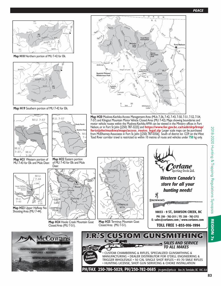
Map H25 Terminus Mountain Goat Closed Area (MU 7-51).
L.1348
L.1323
WagnerRanch
Upper Halfway
Elementary
School
Halfway
Seventyfour M
ile Cr.
Gra
ham
Riv
er
River
M.U.7–44
M.U.7–43 M.U.
7–35
Map H23 Upper Halfway No Shooting Area (MU 7-44).
Riv
er
MU
7-42
MU
7-41
MU
7-50
Prophet River
Muskwa
River
Bessa
Riv
er
Richards Cr.
MU
7-42
97
TRUTCH
River
Map H18 Northern portion of MU 7-42 for Elk.
97
Trout R
.
Liard River Liard
River
Forcier
L.
Lap
ie C
r.
M
ould
Teet
Lapie
Lake
chniak Creek
.
CAMPBELLPEAK
Heig
ht o
f Lan
d
HooleCr.
Map H24 Hoole Creek Mountain Goat Closed Area (MU 7-51).
M.U.
7–36
M.U.
7–37
M.U. 7–57
Graham
Halfway
ChowadeRiver
Creek
Cypress
Map H21 Western portion of MU 7-43 for Elk and Mule Deer.
0 20
M.U.
7–36
M.U.
7–44
M.U. 7–57
WaRanch
Beatton Ranch
Brady Ranch
Graham
Halfway
Chowade
River
River
Creek
Cypress
River
Map H22 Eastern portion of MU 7-43 for Elk and Mule Deer.
L iard
R
ive
r
Fort
Ke
ch
ika
Rab
bit
Riv
er
Fo
x R
.
RiverG
ataga R.
Pitman
Riv
er
R.
Tuch
odi
Heig
ht o
f La
nd
Heig
ht of L
an
d
Nelson
R.
R.
Y U K O N
B. C.
R.
Spatsizi Plateau
Wilderness Park
Kwadacha
TatlatuiPark
Stone Mountain Park
Fort NelsonMuncho
LakePark
Toad RiverExemption
WillistonLake
Thulade
Lake
Height of Land
Wilderness
Park
Red R.
Dease
Rapid R
River
Turnag
ain
R.
Frog
R.
Stikine R.
Finla
y K
w
adacha R.
Akie R.
Ingenika R.
Pelly
C
r.
Osp
ika R
.
Graham R.
Halfway
R.
Sikanni Chie
f R
iver
Muskwa
Prophet
Riv
er
77
97
97
km500
Map H20 Muskwa-Kechika Access Management Area (MUs 7-36, 7-42, 7-43, 7-50, 7-51, 7-52, 7-54, 7-57) and Klingzut Mountain Motor Vehicle Closed Area (MU 7-42). Maps showing boundaries and motor vehicle routes within the Muskwa-Kechika AMA can be viewed in the Ministry offices in Fort Nelson, or in Fort St John [(250) 787-3225] and https://www.for.gov.bc.ca/tasb/slrp/lrmp/fortstjohn/muskwa/maps/access_routes_legal.zip Larger scale maps can be purchased from McElhanney Associates in Fort St. John [(250) 787-0356]. South of district lot 1229 on the West Toad River corridor travel is restricted to within 10 metres of route and vehicles under 750 kg only.
Akie
River1
Prophet River
Muskwa
River
Bessa
Riv
er
Richards Cr.
MU
7-42
MU
7-42
97
TRUTCH
r
SikanniCheif
River
Map H19 Southern portion of MU 7-42 for Elk.
• HUNTING TERRITORIES • FISHING LODGES
• TRAPLINES • RESORTS
www.mccowans.com
LYNZY 250-870-3021
HARRY 250-717-1100
J.R.’S CUSTOM GUNSMITHING
• CUSTOM CHAMBERING & RIFLES, SPECIALIZED GUNSMITHING & MANUFACTURING • DEALER DISTRIBUTOR FOR O’DELL ENGINEERING & TRIGGER WHOLESALE • 50 CAL SINGLE SHOT RIFLES • 45-70 SMLE RIFLES • HUNTING LICENSE, SHOT GUN SERVICING & CHOKE INSTALLATION
SALES AND SERVICE
TO ALL MAKES
Your
Custom
Gunsmith
PH/FAX 250-786-5029, PH/250-782-0685 [email protected] Box 29, Tomslake, BC V0C 2L0
PH: 250 - 782-2111 / FX: 250 - 782-2712E: [email protected] / www.corlanes.com
TOLL FREE 1-855-916-1994
10033 - 9 ST., DAWSON CREEK, BC
Western Canada’s
store for all your
hunting needs!hunting needs!

84
RESOURCE MANAGEMENT REGION 7B2018-2
020 H
unting &
Tra
ppin
g R
egula
tions S
ynopsis
RE
GIO
N 7
BR
EG
ION
7B
Muskwa River Adventures Doug McKee (250) 775-0760
Transport for resident hunters, guiding services forresident and non-resident hunters
•Fuel Drop Boat Repairs/Rescues Meat Hanging Service (on river and in town)
• Drop Camp or Full Camp with Cabins/Cook Option (ATV Rental in Region 7:49 Camp)
• Hunting Territories • Fishing Lodges • Guest Ranches • Residential• Rural Residential • Farms • Ranches • Recreational Properties
www.backcountryproperties.ca
HORST MINDERMANNPersonal Real Estate Corporation
RE/MAX Dawson Creek RealtyIndependently Owned and OperatedLicensed in BC
& Alberta 10224-10th St., Dawson Creek, BC
Cypress
Cr.H
allw
ay
River
MU
7-57
Fid
des
C
r.
Chowade River
MU
7-58
MU
7-48
Headstone
Cr.
Den km
an
C
r.
R
obertson Cr.
Geesdale Cr.
Sidenius
C
reek
Sikanni C
hief
Graham-Laurier
Park
Map H29 Halfway River Caribou Closed Area (MU 7-57).
H
art R
iver
Riv
er
Dall R
.
S
heep
C
r.
Blu
e
Turn
again
Map H28 Deeh Ridge Mountain Goat Closed Area (MU 7-52).
Liard Riv
er
Toad R
ive
r
MunchoLakePark
Milepost480
Milepost435
AlaskaHighway
AlaskaHighway
1.6km (1mi.)either sideof highway
M.U.
7–51
M.U.
7–54
97
Map H27 Muncho Lake Park Mountain Sheep and Mountain Goat Closed Area (MUs 7-51, 7-54).
Lue
C
r.
Tandzie Cr.
T
oad
River
Racin
g R
iver
Tentsi Cr.
Yash
C
r.
Moose
L.
97
97
Lue C
r. Munch
o C
r.
Tandzie Cr.
Otelsas Cr.
Muncho
Lake
Petersen
Cr.
Trout R.
Muncho Lake Park Bound
ary
Yedhe Cr.
Midline of the Valley
Four Mile Cr.
Map H26 Toad River Mountain Goat Closed Area (MUs 7-51, 7-54).