Embed Size (px)
Citation preview
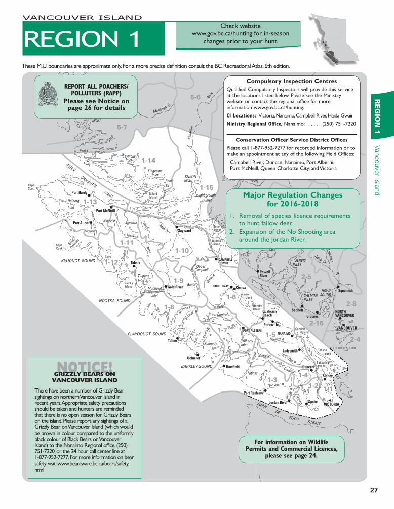
27
RE
GIO
N 1
Vancouver Is
land
2-4
2-8
2-5
2-16
2-12
2-13
2-14
2-15
VICTORIA
Sidney
Duncan
Port Renfrew
Jordan River
Bamfield
Ucluelet
Tofino
Ladysmith
NANAIMOPORT ALBERNI
COURTENAY
CAMPBELL RIVER
ComoxGold River
Tahsis
Sayward
Port McNeill
Port Hardy
Port Alice
Parksville
Squamish
Gibsons
SecheltQualicumBeach
PowellRiver
RiversInlet
VANCOUVER
NORTHVANCOUVER
Sooke
STRAIT
JUAN
DE
FUCA
KYUQUOT SOUND
NOOTKA SOUND
CLAYOQUOT SOUND
BARKLEY SOUND
Great Central L
Tlupana
Inlet
Loughborough
Inlet Holberg
Inlet
KingcomeInlet
SeymourInlet
Bond
Sd
Muchalat
Inlet
Powell
Lake
AlberniInlet
Gabriola Island
Denman Island
QuadraIsland
SonoraIsland
GilfordIsland
NootkaIsland
Brooks
Peninsu
la
CapeCook
CapeScott
HornbyIsland
Texada Island
Galiano Island
Saltspring Island
NitinatL
KennedyL
Taseko
Lakes
Tatlayoko
Lake
UpperCampbellL
ButtleL
VictoriaL
Pack L
NimpkishL
OwikenoL
BonanzaL
Cowichan
L
HOWESOUND
JERVISINLET
SALMONINLET
TOBAINLET
BUTEINLET
CHILKO
LAKE
KNIGHTINLET
RIVERSINLET
San Juan R
Gor
don R
Nanaimo R
Niti
na
t
R
Leech R
Jo
rd
a n R
Muir C
r
Taylor R
Ke
nne
dy
R
Chemainus R
Oyste
r R
Puntledge R
Moy
eha R
Bed
well R
Adam R
Tsitika R
Nimpkish
River
R
Zeba
llos
R
QUEEN
CHARLOTTE
STRAIT
Klin
aklin
i
Rive
r
Homathko
R
Mos
ley
Cr
Chilk
o
R
Taseko R
Bishop R
Toba R
Southgate
R
Big
C
r
Squa mish
R
Elaho R
Ashlu Cr
Lillooet R
Machmell
R
Cowichan R
1-41-3
1-51-7
1-8
1-6
1-9
1-10
1-11
1-12
1-13
1-15
1-14
1-21-1
5-4
5-5
5-6
5-7
5-8
MajorRegulationChanges for2016-2018
1. Removal of species licence requirements to hunt fallow deer.
2. Expansion of the No Shooting area around the Jordan River.
CompulsoryInspectionCentresQualified Compulsory Inspectors will provide this service at the locations listed below. Please see the Ministry website or contact the regional office for more information www.gov.bc.ca/hunting.
CI Locations: Victoria, Nanaimo, Campbell River, Haida Gwaii
Ministry Regional Office, Nanaimo: . . . . . (250) 751-7220
ConservationOfficerServiceDistrictOfficesPlease call 1-877-952-7277 for recorded information or to make an appointment at any of the following Field Offices:
Campbell River, Duncan, Nanaimo, Port Alberni, Port McNeill, Queen Charlotte City, and Victoria
For information on Wildlife Permits and Commercial Licences,
please see page 24.
These M.U. boundaries are approximate only. For a more precise definition consult the BC Recreational Atlas, 6th edition.
REGION 1
VANCOUVER ISLAND
REPORT ALL POACHERS/POLLUTERS (RAPP)
PleaseseeNoticeon
page26fordetails
Check website www.gov.bc.ca/hunting for in-season
changes prior to your hunt.
NOTICE!GRIZZLY BEARS ON
VANCOUVER ISLAND
There have been a number of Grizzly Bear sightings on northern Vancouver Island in recent years. Appropriate safety precautions should be taken and hunters are reminded that there is no open season for Grizzly Bears on the island. Please report any sightings of a Grizzly Bear on Vancouver Island (which would be brown in colour compared to the uniformly black colour of Black Bears on Vancouver Island) to the Nanaimo Regional office, (250) 751-7220, or the 24 hour call center line at 1-877-952-7277. For more information on bear safety visit: www.bearaware.bc.ca/bears/safety.html
28
Vancouver
Isla
nd
RE
GIO
N 1
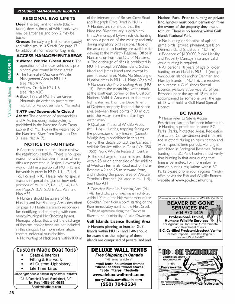
REGIONALBAGLIMITSDeer: The bag limit for mule (black-tailed) deer is three, of which only two may be antlerless and only 2 may be bucks.Grouse: The daily bag limit for blue (sooty) and ruffed grouse is 5 each. See page 17 for additional information on bag limits.
ACCESSMANAGEMENTAREASH Motor Vehicle Closed Areas: The
operation of all motor vehicles is pro-hibited year round in these areas:
H The Parksville-Qualicum Wildlife Management Area in MU 1-5 (see Map A19)
H Willow Creek in MU 1-6 (see Map A20)
H Block 1392 of MU 1-5 on Green Mountain (in order to protect the habitat for Vancouver Island Marmots)
i ATV and Snowmobile Closed
Areas: The operation of snowmobiles and ATVs (including motorcycles) is prohibited in the Nanaimo River Camp (Zone B of MU 1-5) in the watershed of the Nanaimo River from Sept 1 to Dec 31 (see Map A17).
NOTICETOHUNTERS4Antlerless deer hunters please review the regulations carefully. There is no open season for antlerless deer in areas where rifles are permitted in Region 1 except by way of LEH in a portion of MU 1-15 and foryouthhuntersinMU's1-1,1-2,1-4,1-5, 1-6, and 1-10. Please refer to special seasons in special shotgun or bow only portionsofMU's1-2,1-4,1-5,1-6,1-15:see Maps A13, A15, A16, A22, A23 and Map A35.4Hunters should be aware of No Hunting and No Shooting Areas described on page 13. Hunters are also responsible for identifying and complying with com-munity/municipal No Shooting bylaws. Municipal bylaws that affect the discharge of firearms and/or bows are not included in this synopsis. For more information, contact individual municipalities. 4No hunting of black bears within 800 m
of the intersection of Beaver Cove Road and Telegraph Cove Road in MU 1-114Hunters are reminded that the Nanaimo River estuary is within city limits. A municipal bylaw restricts hunting to only a portion of the estuary and only during migratory bird seasons. Maps of the area open to hunting are available for viewing at the Ministry Regional Office in Nanaimo, or from the City of Nanaimo.4The discharge of rifles is prohibited in MU 1-1 except on Valdes Island, Sidney Island and James Island (and except by permit elsewhere). Note: No Shooting or Hunting areas in MU 1-1, Maps A2 to A6.4Nanoose Bay No Shooting Area (MU 1-5) - From the mean high water mark at the southeast corner of the Qualicum National Wildlife Area east to the mean high water mark on the Department of Defence property line and the shore area between these points (400 m out onto the water from the mean high water mark).4Qualicum National Wildlife Areas (MU 1-6) - Hunting, trapping, fishing or the possession of any firearm (Canada Wildlife Act) is prohibited in this area. For further details contact the Canadian Wildlife Service office in Delta (604-350-1950) Pacific Wildlife Research Centre.
4The discharge of firearms is prohibited within 25 m on either side of the midline of Westcan Terminals Road east of Indian Reserve #9 and 25 m seaward from, and including the paved area of Westcan Terminals Port site (situated in MU 1-4). See Map A11.4Cowichan River No Shooting Area (MU 1-4). The discharge of firearms is Prohibited within 100 m of the high water mark of the Cowichan River from a point starting on the River immediately north of the Holt Creek Trailhead upstream along the Cowichan River to the Municipality of Lake Cowichan.
Gulf Islands Licence Hunting Area
4Hunters planning to hunt on Gulf Islands within MU 1-1 and 1-06 should be aware that the majority of these islands are comprised of private land and
National Park. Prior to hunting on private land, hunters must obtain permission from the owner of the property they intend to hunt. There is no hunting within Gulf Islands National Park.
4No hunting or shooting of upland game birds (grouse, pheasant, quail) on Denman Island (situated in MU 1-6).4Evidence of $100,000 Public Liability and Property Damage insurance valid while hunting is required.4All persons 18 years of age or older hunting on an island in MU 1-1 (except Vancouver Island) and/or Denman and Hornby Islands in MU 1-6, are required to purchase a Gulf Islands Special Licence, available at Service BC offices. Persons under the age of 18 must be accompanied by someone over the age of 18 who holds a Gulf Island Special Licence.
BCPARKS4Please refer to Site & Access Restrictions section for more information.4Hunting is prohibited in some BC Parks (Parks, Protected Areas, Recreation Areas, and Conservancies) and is permit-ted in others during an open season and within specific time periods. Hunting is prohibited in Ecological Reserves. Before hunting in a BC Park, hunters must verify that hunting in that area during that time is permitted. For more informa-tion on hunting regulations within BC Parks please phone your regional Ministry office or visit the Fish and Wildlife Branch website at www.gov.bc.ca/hunting.
RESOURCE MANAGEMENT REGION 1
Preventing and Resolving Human-Wildlife Confl icts
Licensed Trappers, Permitted Region 2, Insured, WorkSafeBC
BEAVER BE GONE SERVICES INC.604-970-4449
Professional, Ethical,Humane Wildlife Services
For Agricultural, Industrial, Governmental and Residential Clients
B.C. Certifi ed Predator/Livestock Verifi er
BEAVER BE GONE SERVICES INC.604-970-4449
Custom-Made Boat Tops• Seats & Interiors• Fitting & Bar work• All Custom-Upholstery• Life Time Tarps
Made right here in Canada by Shadow Leathers
2316 Campbell Road, Vanderhoof, B.C.Toll Free 1-888-901-5818
Shadowleathers.com
www.deluxewalltents.com
(250) 704-2534
Free Shipping In CanadaDELUXE WALL TENTS
*with some restrictions*
*wall tents *aluminum frames*diesel heaters *wood stoves
*cots *tarps *bedrolls
29
RE
GIO
N 1
Vancouver Is
land
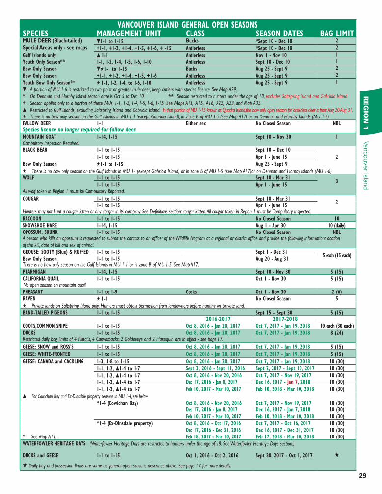
VANCOUVER ISLAND GENERAL OPEN SEASONSSPECIES MANAGEMENT UNIT CLASS SEASON DATES BAG LIMITMULE DEER (Black-tailed)Special Areas only - see maps
t1-1 to 1-15 Bucks *Sept 10 - Dec 10 2
+1-1, +1-2, +1-4, +1-5, +1-6, +1-15 Antlerless *Sept 10 - Dec 10 2
Gulf Islands only s 1-1 Antlerless Nov 1 - Nov 10 1
Youth Only Season** 1-1, 1-2, 1-4, 1-5, 1-6, 1-10 Antlerless Sept 10 - Dec 10 1
Bow Only Season tH1-1 to 1-15 Bucks Aug 25 - Sept 9 2
Bow Only Season +1-1, +1-2, +1-4, +1-5, +1-6 Antlerless Aug 25 - Sept 9 2
Youth Bow Only Season** H 1-1, 1-2, 1-4, to 1-6, 1-10 Antlerless Aug 25 - Sept 9 1
t A portion of MU 1-6 is restricted to two point or greater mule deer; keep antlers with species licence. See Map A29.* On Denman and Hornby Island season date is Oct 5 to Dec 10 ** Season restricted to hunters under the age of 18, excludes Saltspring Island and Gabriola Island+ Season applies only to a portion of these MUs. 1-1, 1-2, 1-4, 1-5, 1-6, 1-15 See Maps A13, A15, A16, A22, A23, and Map A35. s Restricted to Gulf Islands, excluding Saltspring Island and Gabriola Island. In that portion of MU 1-15 known as Quadra Island, the bow only open season for antlerless deer is from Aug 20-Aug 31.H There is no bow only season on the Gulf Islands in MU 1-1 (except Gabriola Island), in Zone B of MU 1-5 (see Map A17) or on Denman and Hornby Islands (MU 1-6).FALLOW DEER 1-1 Either sex No Closed Season NBLSpecies licence no longer required for fallow deer.MOUNTAIN GOAT 1-14, 1-15 Sept 10 – Nov 30 1Compulsory Inspection Required.BLACK BEAR 1-1 to 1-15 Sept 10 – Dec 10
21-1 to 1-15 Apr 1 - June 15
Bow Only Season H1-1 to 1-15 Aug 25 - Sept 9
H There is no bow only season on the Gulf Islands in MU 1-1(except Gabriola Island) or in zone B of MU 1-5 (see Map A17)or on Denman and Hornby Islands (MU 1-6).WOLF 1-1 to 1-15 Sept 10 - Mar 31
31-1 to 1-15 Apr 1 - June 15
All wolf taken in Region 1 must be Compulsory Reported.
COUGAR 1-1 to 1-15 Sept 10 - Mar 312
1-1 to 1-15 Apr 1 - June 15Hunters may not hunt a cougar kitten or any cougar in its company. See Definitions section: cougar kitten. All cougar taken in Region 1 must be Compulsory Inspected.RACCOON 1-1 to 1-15 No Closed Season 10SNOWSHOE HARE 1-14, 1-15 Aug 1 - Apr 30 10 (daily)OPOSSUM, SKUNK 1-1 to 1-15 No Closed Season NBLA person who kills an opossum is requested to submit the carcass to an officer of the Wildlife Program at a regional or district office and provide the following information: location of the kill, date of kill and sex of animal.GROUSE: SOOTY (Blue) & RUFFED 1-1 to 1-15 Sept 1 - Dec 31
5 each (15 each)Bow Only Season 1-1 to 1-15 Aug 20 - Aug 31There is no bow only season on the Gulf Islands in MU 1-1 or in zone B of MU 1-5. See Map A17. PTARMIGAN 1-14, 1-15 Sept 10 - Nov 30 5 (15)CALIFORNIA QUAIL 1-1 to 1-15 Oct 1 - Nov 30 5 (15)No open season on mountain quail.PHEASANT 1-1 to 1-9 Cocks Oct 1 - Nov 30 2 (6)RAVEN H 1-1 No Closed Season 5
H Private lands on Saltspring Island only. Hunters must obtain permission from landowners before hunting on private land.BAND-TAILED PIGEONS 1-1 to 1-15 Sept 15 – Sept 30 5 (15)
2016-2017 2017-2018COOTS,COMMON SNIPE 1-1 to 1-15 Oct 8, 2016 - Jan 20, 2017 Oct 7, 2017 - Jan 19, 2018 10 each (30 each)DUCKS 1-1 to 1-15 Oct 8, 2016 - Jan 20, 2017 Oct 7, 2017 - Jan 19, 2018 8 (24)Restricted daily bag limits of 4 Pintails, 4 Canvasbacks, 2 Goldeneye and 2 Harlequin are in effect - see page 17.
GEESE: SNOW and ROSS’S 1-1 to 1-15 Oct 8, 2016 - Jan 20, 2017 Oct 7, 2017 - Jan 19, 2018 5 (15)
GEESE: WHITE-FRONTED 1-1 to 1-15 Oct 8, 2016 - Jan 20, 2017 Oct 7, 2017 - Jan 19, 2018 5 (15)
GEESE: CANADA and CACKLING 1-3, 1-8 to 1-15 Oct 8, 2016 - Jan 20, 2017 Oct 7, 2017 - Jan 19, 2018 10 (30)
1-1, 1-2, s1-4 to 1-7 Sept 3, 2016 - Sept 11, 2016 Sept 2, 2017 - Sept 10, 2017 10 (30)
1-1, 1-2, s1-4 to 1-7 Oct 8, 2016 - Nov 20, 2016 Oct 7, 2017 - Nov 19, 2017 10 (30)
1-1, 1-2, s1-4 to 1-7 Dec 17, 2016 - Jan 8, 2017 Dec 16, 2017 - Jan 7, 2018 10 (30)
1-1, 1-2, s1-4 to 1-7 Feb 10, 2017 - Mar 10, 2017 Feb 10, 2018 - Mar 10, 2018 10 (30)
s For Cowichan Bay and Ex-Dinsdale property seasons in MU 1-4, see below*1-4 (Cowichan Bay) Oct 8, 2016 - Nov 20, 2016 Oct 7, 2017 - Nov 19, 2017 10 (30)
Dec 17, 2016 - Jan 8, 2017 Dec 16, 2017 - Jan 7, 2018 10 (30)Feb 10, 2017 - Mar 10, 2017 Feb 10, 2018 - Mar 10, 2018 10 (30)
*1-4 (Ex-Dinsdale property) Oct 8, 2016 - Oct 17, 2016 Oct 7, 2017 - Oct 16, 2017 10 (30)Dec 17, 2016 - Dec 31, 2016 Dec 16, 2017 - Dec 31, 2017 10 (30)
* See Map A11. Feb 18, 2017 - Mar 10, 2017 Feb 17, 2018 - Mar 10, 2018 10 (30)
WATERFOWLER HERITAGE DAYS: (Waterfowler Heritage Days are restricted to hunters under the age of 18. See Waterfowler Heritage Days section.)
DUCKS and GEESE 1-1 to 1-15 Oct 1, 2016 - Oct 2, 2016 Sept 30, 2017 - Oct 1, 2017 H
H Daily bag and possession limits are same as general open seasons described above. See page 17 for more details.
30
Vancouver
Isla
nd
RE
GIO
N 1
RESOURCE MANAGEMENT REGION 1
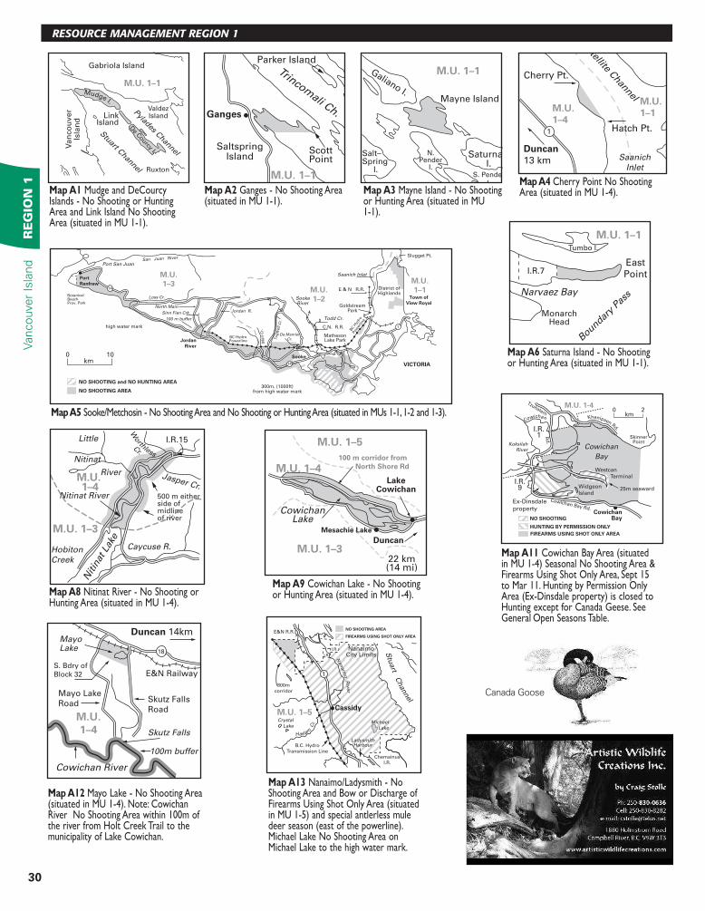
MapA1 Mudge and DeCourcy Islands - No Shooting or Hunting Area and Link Island No Shooting Area (situated in MU 1-1).
MapA2Ganges - No Shooting Area (situated in MU 1-1).
MapA3 Mayne Island - No Shooting or Hunting Area (situated in MU 1-1).
NO SHOOTING and NO HUNTING AREA
NO SHOOTING AREA
SookeRiver
M.U.
1–1M.U.
1–2
M.U.
1–3
14
14
1
Slugget Pt.
District ofHighlands
E & N R.R.
C.N. R.R.
GoldstreamPark
MathesonLake ParkJordan
River
Port
Renfrew
Port San Juan
Todd Cr.
Da Mamier
Cr.
Jordan R.
Loss Cr.
San Juan River
Mu
ir C
r.
Tu
gw
ell C
r.
Town of
View Royal
high water mark
BC H
ydro
Pow
erlin
e
BC HydroPowerline
BotanicalBeachProv. Park
VICTORIA
Saanich Inlet
100km
300m. (1000ft)from high water mark
Sooke
Sinn Fien Crk.
North Main
100 m buffer
M.U. 1–1
Gabriola Island
Stuart C
hannel
Pylades Channel
LinkIsland
Ruxton
ValdezIsland
Van
co
uver
Isla
nd
De C
ourcy I.
Mudge I.
Parker Island
Ganges
ScottPoint
SaltspringIsland
Trincomali Ch.
M.U. 1–1
Mayne Island
Galiano I.
Saturna I.
Salt–Spring I.
S. Pender
I.
N.Pender
I.
M.U. 1–1
Tumbo I.
I.R.7East
Point
MonarchHead
Narvaez Bay
Boundary
Pass
M.U. 1–1
M.U. 1–5
M.U. 1–4
M.U. 1–3
CowichanLake
Duncan
22 km(14 mi)
LakeCowichan
Mesachie Lake
100 m corridor from
North Shore Rd
M.U. 1-4
SkinnerPoint
Cowichan
Bay
Westcan
Terminal
25m seawardWidgeon
Island
CowichanBay
Cowichan Bay Rd.
Koksilah
River
Tzuhalem
Rd
.
NO SHOOTING
HUNTING BY PERMISSION ONLY
FIREARMS USING SHOT ONLY AREA
Khenipsen Rd.
Cowichan
Ex-Dinsdale
property
I.R.9
I.R.1
0 2kmMapA5 Sooke/Metchosin - No Shooting Area and No Shooting or Hunting Area (situated in MUs 1-1, 1-2 and 1-3).
MapA6 Saturna Island - No Shooting or Hunting Area (situated in MU 1-1).
Little
Jasper Cr.
Nitinat
River
Nitinat River
Nitin
at L
ake
Hobiton
Creek
Caycuse R.
500 m either side of midline of river
M.U. 1–3
M.U. 1–4
Worthless
C
r.
I.R.15
MapA8 Nitinat River - No Shooting or Hunting Area (situated in MU 1-4).
MapA11 Cowichan Bay Area (situated in MU 1-4) Seasonal No Shooting Area & Firearms Using Shot Only Area, Sept 15 to Mar 11. Hunting by Permission Only Area (Ex-Dinsdale property) is closed to Hunting except for Canada Geese. See General Open Seasons Table.
MapA9 Cowichan Lake - No Shooting or Hunting Area (situated in MU 1-4).
M.U.
1–4
E&N Railway
Duncan 14kmMayo Lake
Mayo Lake
RoadSkutz Falls
Road
Skutz Falls
Cowichan River
S. Bdry of
Block 32
18
100m buffer
MapA12 Mayo Lake - No Shooting Area (situated in MU 1-4). Note: Cowichan River No Shooting Area within 100m of the river from Holt Creek Trail to the municipality of Lake Cowichan.
E&N R.R.
NanaimoCity Limits
Stu
art C
hannel
I.R.
I.R.
Nanaim
o R
iver
Haslam
Cr. Crystal
LakeMichael
Lake
LadysmithHarbour
Cassidy
Chemainus
I.R.
800m
corridor
B.C. Hydro
Transmission Line
M.U. 1–5
1
NO SHOOTING AREA
FIREARMS USING SHOT ONLY AREA
MapA13Nanaimo/Ladysmith - No Shooting Area and Bow or Discharge of Firearms Using Shot Only Area (situated in MU 1-5) and special antlerless mule deer season (east of the powerline). Michael Lake No Shooting Area on Michael Lake to the high water mark.
M.U.
1–1M.U.
1–4Satellite C
hannelCherry Pt.
Duncan
13 km
Hatch Pt.1
Saanich
Inlet
MapA4Cherry Point No Shooting Area (situated in MU 1-4).
Canada Goose
31
RE
GIO
N 1
Vancouver Is
land
VANCOUVER ISLAND
Saanich
Inlet
Malahat Drive(Hwy #1)
Cra
gg C
ree
k
Leech River
West Leech R
.
Sooke
Lake
Butchart
Lubbe
&
Goldstream
Reservoirs
Soo
k
e Riv
er
Bear Cr.Reservoir
Shawnigan
Lake
Old WolfCr.
GrantLake
Lake
Weeks
Rith
et C
r.
Sooke Road(Hwy #14)
Charters
R.
Veitc
h C
r.
Council
Lk. & Cr.
Lake
Jarvis
DiversionReservoir
RenfrewRoad
West JordanMain
ButlerMain
South ShawniganLake Road
Res.
ShieldsLake
Lake
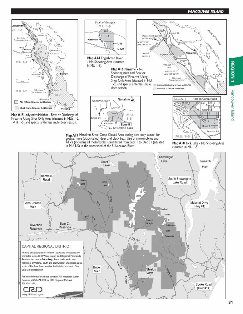
CAPITAL REGIONAL DISTRICT
Hunting and discharge of firearms, bows and crossbows are
prohibited within CRD Water Supply and Regional Park lands.
Represented here in Dark Grey, these lands are located
northwest of Victoria, south and southwest of Shawnigan Lake,
south of Renfrew Road, west of the Malahat and east of the
Bear Creek Reservoir.
For more information please contact CRD Integrated Water
Services at 250.474.9600 or CRD Regional Parks at
250.478.3344.
Strait of Georgia
Parksville
En
glishm
an
R.
L.181
L.1
L.96
L.129
M.U. 1–5
19
MapA14Englishman River - No Shooting Area (situated in MU 1-5).
NO SHOOTING AREA, SPECIAL ANTERLESS
Witchcraft
Lake
Strait of Geo
rgia
Nan
aimo C
ity Limits
City
Lim
its
GreenLake
BrannenLake
WestwoodLake
800m west
Transmission Line
E&N R.R.
Nanaimo
1
I.R.
I.R.
Dumont Rd
W
eigles R
d
End of
pavement
Lat 49° 15’ 27’’
Long 124° 00’ 17”
Lat 49° 19’ 37’’
Long 124° 10’ 07”
Transmission Line
Interseection Biggs Rd
and Dumont RD
SHOT ONLY, SPECIAL ANTERLESS
Jingle Pot Rd
19
Island Hwy
100km
1
18
Ladysmith
Duncan
Sidney
B.C. Hydro
Transmission Line
B.C. Hydro
Transmission Line
Christmas Pt
Shawnigan
Lake
Cowichan Bay
Saltspring
Island
ThetisI
Penelakut I
M.U. 1–5
M.U. 1–4
M.U. 1–2
M.U. 1–1
Strait of G
eorg
ia
Victoria
Colwood
Goldstream
No Rifles, Special Antlerless
Shot Only, Special Antlerless
Nanaimo
Zone B
Nanaimo River
Sadie Cr.Jump Cr.
S. Nanaimo R.
Cowichan Lake
M.U.
1–5
M.U. 1–5
Holden Corso RoadTorberg Rd.
Mari
ne R
d.
Walsh Rd.McM
illan
Rd.
Block
9
Block 7
Ryeland Rd.
Sanford W
ay
Cedar Rd.
York Lake
Lot
1
2
1 2 3
697
8
3 7
5 4 8
Block 8Block 6
MapA17 Nanaimo River Camp Closed Area during bow only season for grouse, mule (black-tailed) deer and black bear. Use of snowmobiles and ATV’s (including all motorcycles) prohibited from Sept 1 to Dec 31 (situated in MU 1-5) in the watershed of the S. Nanaimo River.
MapA18 York Lake - No Shooting Area (situated in MU 1-5).
MapA15Ladysmith/Malahat - Bow or Discharge of Firearms Using Shot Only Area (situated in MUs 1-2, 1-4 & 1-5) and special antlerless mule deer season.
MapA16 Nanaimo - No Shooting Area and Bow or Discharge of Firearms Using Shot Only Area (situated in MU 1-5) and special anterless mule deer season.
32
Vancouver
Isla
nd
RE
GIO
N 1
RESOURCE MANAGEMENT REGION 1
D.L73 E&N
Englishman
River
Craig
Cr.
Carey
Cr.
FrenchCreek
Parksville
QualicumBeach
GrandonCr.
Fren
ch C
r.M
om
ingst
er C
r.
Little QualicumR.
S. 17
S.16 S.16
D.L. 222
Willow Creek
Alder S
t.
FR NW 1/4 S16FR NW 1/4 S16
Ericks
on
Road
Will
ow
Cre
ek
Rd
.W
illo
w C
reek
Rd
.
Plan 11621
ParkPark
D.L. 141
D.L. 178
D.L. 223
D.L. 151
Kuhushan
Point
Oyster
Pond
Oyst
erR.
Marina
Marina
D.L. 225
D.L. 193
19
Oyster Garden
Road
Salmon Point Road
0 0.5km
M.U. 1–6
19A
19
Strait of G
eorgia
CampbellRiver DistrictBoundary(No Shooting Area)
Comox Strathcona Reg Dist. Bdry
WolfLake
ComoxLake Denman I.
Hornby I.
CourtenayComox
M.U.1–6
Qualicum R.
Englishman R.
Deep Bay
Dumont Rd.
B.C. Hydro
Transmission Line
QualicumBeach
Parksville
Strait of Georgia
M.U.
1–6
M.U. 1–5
19A19
Comox Harbour Strait
of Georg
ia
L.195
L.156
Pipeline to CFB
Lazo Rd
Lazo
Pri
tch
ard
Rd
L.245
L.244
M.U.
1–6
Comox
Marsh
M.U. 1-6
Comox
Courtenay
Royston
Co
mox Harbour
Tsolum R.
Puntledge R. Court
enay
R. 19
Denman
Is.
Comox Lake
Goose Spit
Gartley
Point
Iron R
iver
Mt.Adrian
Alexandra
Peak
Mt.
Washington
Mt.
Washington
Oyst
er
Riv
er
Q
uinsam R.
B
alsa
m
Cr.
Beadnel
l Lk.
STRATHCONA
PROVINCIAL
PARK
STRATHCONA
PROVINCIAL
PARK
M.U.1-6
19
LukwaL
L. 325
LukwaCr
Miller
Arg
on
au
tM
ain
lin
e
Cr
300° 920m
300m
600m
500m
1030
m
QuinsamRiver M.U. 1-6
MiddleQuinsam
Lake
49°57'00'' N Lat 125°26'30'' W Long125°30'00'' W Long
125°30'00'' W Long 49°54'30''N Lat
Qu
insam River
Iro
n R
iver
P a c i f i c
O c e a n
Ucl u
el e
t I nl e
t
PortAlbion
Ucluelet Kakw
eik
en
Riv
er
Spawning
Channels
L.497 M.U.
1–15
M.U.
1–12
Nimpkish
Forest
Stevens
Peak
Height of land
Tlupana Inlet
Gold River
Conuma
Peak
Co
num
a River
C
anton C
r.
Muchalat River
MapA19 Parksville-Qualicum Wildlife Management Area (WMA) (situated in MU 1-5) Motor Vehicle Closed Area.
MapA20 Willow Creek Motor Vehicle Closed Area (situated in MU 1-6). MapA21 Woodhus Slough No
Hunting Area (situated in MU 1-6).
MapA22 Courtenay/Campbell River - Bow or Firearms Using Shot Only Area (situated in MU 1-6) and special antlerless mule deer season. Gulf Island Special Licence is required on Denman and Hornby Islands - see page 28.
MapA23 Qualicum/Parksville - Bow or Firearms Using Shot Only Area (situated in MUs 1-5, 1-6) and special antlerless mule deer season.
MapA24 Lazo Marsh No Shooting or Hunting Area (situated in MU 1-6).
MapA25 Comox Harbour No Shooting Area (situated in MU 1-6).
Pipeline
Johnstone
Island
Alberni
InletI.R.
SomassRiver
Port
Alberni
Mun.
BdryShoe-
maker
Bay 268m
(880ft)
M.U.
1–7
MapA26 Lukwa Lake No Hunting Area (situated in MU 1-6).
MapA27 Quinsam Coal Mine Site No Shooting Area (situated in MU 1-6).
MapA28 Shoemaker Bay No Shooting Area (situated in MU 1-7).
MapA29 Iron River/Oyster River Special 2 Point or better (and Youth Only anter-less) Mule Deer Hunting Area (situated in MU 1-6).
MapA30 Ucluelet Inlet No Hunting or Shooting Area (situated in MU 1-8).
MapA31 Kakweiken River Grizzly Bear and Black Bear Closed Area (situated in MU 1-15).
MapA32 Conuma Watershed Bow Only Area (situated in MU 1-12). Open for Bow Only Hunting of all big game with open seasons in MU 1-12.
33
RE
GIO
N 1
Vancouver Is
land
VANCOUVER ISLAND
Victoria’s Hunting & Fishing Center.Come see us!
3319 Douglas StreetVictoria, BC
Toll free 1-866-915-4254 or 250-475-4969
• Full line of fi rearms
• Insurance appraisals
• Estate sale fi rearms
• Gunsmith services
• Consignment
• Binoculars, cases, safes, scopes… and a heck of a lot more.
Our store has over 20,000 items from some of the fi nest manufacturers in the world.
info@fi shingvictoria.com • www.islandoutfi tters.ca
KingcomeRiver
KingcomeInlet
Kingcome
Mainline
Logging
Road L.145 L.147
L.144
L.143
L.140
L.139 L.138
L.137
M.U. 1-14
BuckleyBay
BaseFlat
450m
450m
99A
Mean highwater mark
sable Riv
er
Lot 44
Sec. 2 Lot 1
Fanny
E&N
R (C
PR)
100 m
100m
S
tam
p R
iver
StampLagoon Turtle C
r.
100m
Ro
bert
son C
r.
Burman R.
Talbot Cr.
Moye
ha R.
Bed
well
R
. McBride Cr.
Shelter
Inlet
Shelter
Inlet M.U.1-8
Strathcona
Park
Great Central L.
Megin
KnightInlet
Stanton Cr.
Fra
nkli
n R
iver
KlinakliniRiver
Main Bridge
Crossing on
Klinaklini
River
Mt. Blair
Swampfly Pk.
Costello
Peak.
Village
Cone
M.U.
1–15
M.U.1-14
L. 72
L. 64
L. 69
WakemanSound
WakemanSoundmainlineloggingroad
Quadra Island
RebeccaSpit
ProvincialPark
NorthGowlandHar. Rd.
LakbergRoad
Campbell
River
M.U.
1–15
ISLA
ND
HIG
HW
AY
Tra
sk R
d.
Tra
sk R
d.
E.R
.I. R
oad
E.R
.I. R
oad
McP
hedra
n R
d.
PrivateLand Private
Land
WaterTower
Airp
ort M
ain
South Simms C
r.
Do
gw
oo
d
Tim
berl
ine
Sch
oo
l/C
olleg
eC
om
ple
x
North Sim
ms
Cr.
M.U. 1–15
km0 5
Pete
Lake
Martin
Lake Glendale Creek
Tom B
row
ne L
Gle
ndale Cove
Knight
Inlet
FloraPeak
KeoghIR 2
MacdonaldPt
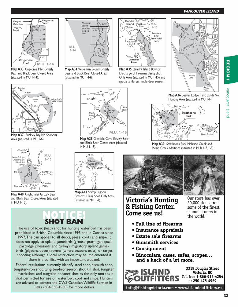
MapA33 Kingcome Inlet Grizzly Bear and Black Bear Closed Area (situated in MU 1-14).
MapA34 Wakeman Sound Grizzly Bear and Black Bear Closed Area (situated in MU 1-14).
MapA35 Quadra Island Bow or Discharge of Firearms Using Shot Only Area (situated in MU 1-15) and special antleress mule deer season.
MapA36 Beaver Lodge Trust Lands No Hunting Area (situated in MU 1-6).
MapA39 Strathcona Park McBride Creek and Megin Creek additions (situated in MUs 1-7, 1-8).
MapA41Stamp Lagoon Firearms Using Shot Only Area (situated in MU 1-7).
MapA37 Buckley Bay No Shooting Area (situated in MU 1-6).
MapA40Knight Inlet Grizzly Bear and Black Bear Closed Area (situated in MU 1-15).
MapA38Glendale Cove Grizzly Bear and Black Bear Closed Area (situated in MU 1-15).
NOTICE!SHOT BAN
The use of toxic (lead) shot for hunting waterfowl has been prohibited in British Columbia since 1995 and in Canada since
1997. The ban applies to all ducks, geese, coots and snipe. It does not apply to upland gamebirds (grouse, ptarmigan, quail,
partridge, pheasants and turkey), migratory upland game-birds (pigeons, doves), ravens (where seasons exist), or target shooting, although a local restriction may be implemented if
there is a conflict with an important wetland.
Federal regulations currently identify steel shot, bismuth shot, tungsten-iron shot, tungsten-bronze-iron shot, tin shot, tungsten - matrixshot, and tungsten-polymer shot as the only non-toxic shot permitted for use on waterfowl, coot and snipe. Hunters are advised to contact the CWS Canadian Wildlife Service in
Delta (604-350-1950) for more details.