Embed Size (px)
Citation preview
Shoemaker, M.L., N.L. Anderson, A.W. Hatheway, T. Newton, S. Cardimona, A. Shaw, J.A. Baker, D.A. Webb, and J. Conley, "Reflection Seismic and Ground-Penetrating Radar Study of Previously Mined (Lead/Zinc) Ground, Joplin, Missouri," Missouri Department of Transportation special publication, 2000. Available on CD (FHWA) and on MoDOT web site. Hard copies in press.
1
REFLECTION SEISMIC AND GROUND-PENETRATING RADAR STUDY OF PREVIOUSLY MINED (LEAD/ZINC) GROUND,
JOPLIN, MISSOURI
Mike L. Shoemaker*, Neil L. Anderson*, Allen W.Hatheway+, Timothy E. Newton ̂Steve Cardimona*, Anthony E. Shaw*, Jesse A. Baker*, Doyle Webb* and Jim Conley ̂
*Department of Geology and Geophysics, University of Missouri-Rolla, Rolla, Missouri +Department of Geological Engineering, University of Missouri-Rolla, Rolla, Missouri
^Missouri Department of Transportation, Jefferson City, Missouri
ABSTRACT
The University of Missouri-Rolla (UMR) conducted a reflection seismic/ground-penetrating radar survey for the Missouri Department of Transportation (MoDOT) along segments of proposed interstate route Alternate “E”, near Joplin, Missouri across ground previously mined for lead/zinc. A total of 14,600 lineal meters of shallow reflection seismic data, nine down-hole seismic calibration check shots, and 15,000 lineal meters of ground penetrating radar (GPR) data were acquired. The seismic data were acquired to map Mississippian bedrock, locate and identify paleosinkholes and abandoned mine features, and determine structural geologic trends in the study area. The GPR data were acquired to identify and locate abandoned mine access and ventilation shafts in areas that were overlain by surficial milled ore rock (chat). Pre-construction knowledge of these anthropogenic and natural features will assist in route selection and geotechnical site mitigation, and minimize both the potential for contractor variable site condition claims and the potential for long-term subsidence-related problems.
The geophysical survey was successful in meeting MoDOT goals. The interpretation of the seismic data, and corroborative engineering geologic field mapping and drilling, established that the shallow reflection seismic technique can be used in the Joplin area to map bedrock structure (including probable fault lineaments and paleosinkholes), locate abandoned, in-filled and/or caved-in open pit mines; and define areas of probable shallow mining activity. The interpretation of the GPR data established that the GPR technique can be used in the Joplin area to locate abandoned mine access and ventilation shafts, even where such shafts are in-filled and overlain by a thin veneer of mill-waste products.
INTRODUCTION
During the winters of 1996/1997 and 1997/1998, the Department of Geology and Geophysics at the
University of Missouri-Rolla conducted a geophysical survey for the Missouri Department of Transportation along proposed interstate route Alternate “E”, Joplin, Missouri (Figure 1). The survey area had been extensively open-pit and subsurface mined for lead/zinc ore, and the integrity of the ground was suspect. In total, 14,600 lineal meters of shallow reflection seismic data, 15,000 lineal meters of ground-penetrating radar data, and nine down-hole seismic calibration check shots were acquired. These geophysical data were acquired to target specific objectives:
1. MoDOT wanted to determine whether reflection seismic data could provide a continuous image of the subsurface to a depth of 100 m. The goal was to map Mississippian bedrock, locate and identify paleosinkholes and abandoned mine features, and determine structural geologic trends in the study area.
2. MoDOT wanted to determine whether GPR data could be used to detect and map abandoned
mine access and ventilation shafts in areas where such shafts were in-filled and overlain by a thin veneer (<3 m) of surficial milled ore rock (chat).
Shoemaker, M.L., N.L. Anderson, A.W. Hatheway, T. Newton, S. Cardimona, A. Shaw, J.A. Baker, D.A. Webb, and J. Conley, "Reflection Seismic and Ground-Penetrating Radar Study of Previously Mined (Lead/Zinc) Ground, Joplin, Missouri," Missouri Department of Transportation special publication, 2000. Available on CD (FHWA) and on MoDOT web site. Hard copies in press.
2
Pre-construction knowledge of the location and nature of these anthropogenic and natural features will assist in route selection and geotechnical site mitigation, and minimize both the potential for contractor variable site condition claims and the potential for long-term subsidence-related problems.
GEOLOGICAL/MINING OVERVIEW OF STUDY AREA
Paleozoic bedrock in the Joplin area is extensively fractured Mississippian carbonate and chert
(Figures 1, 2 and 3). These strata are typically overlain by up to 10 meters of alluvium, soil, and chat. In places, elongate paleosinkholes formed along predominantly north-northwest trending dissolution-widened joints (Figure 3). These paleosinkholes are typically in-filled as depositional inliers of Pennsylvanian shales, siltstones, sandstones, limestones and coals (some contain in excess of 50 m of this secondary in-filling).
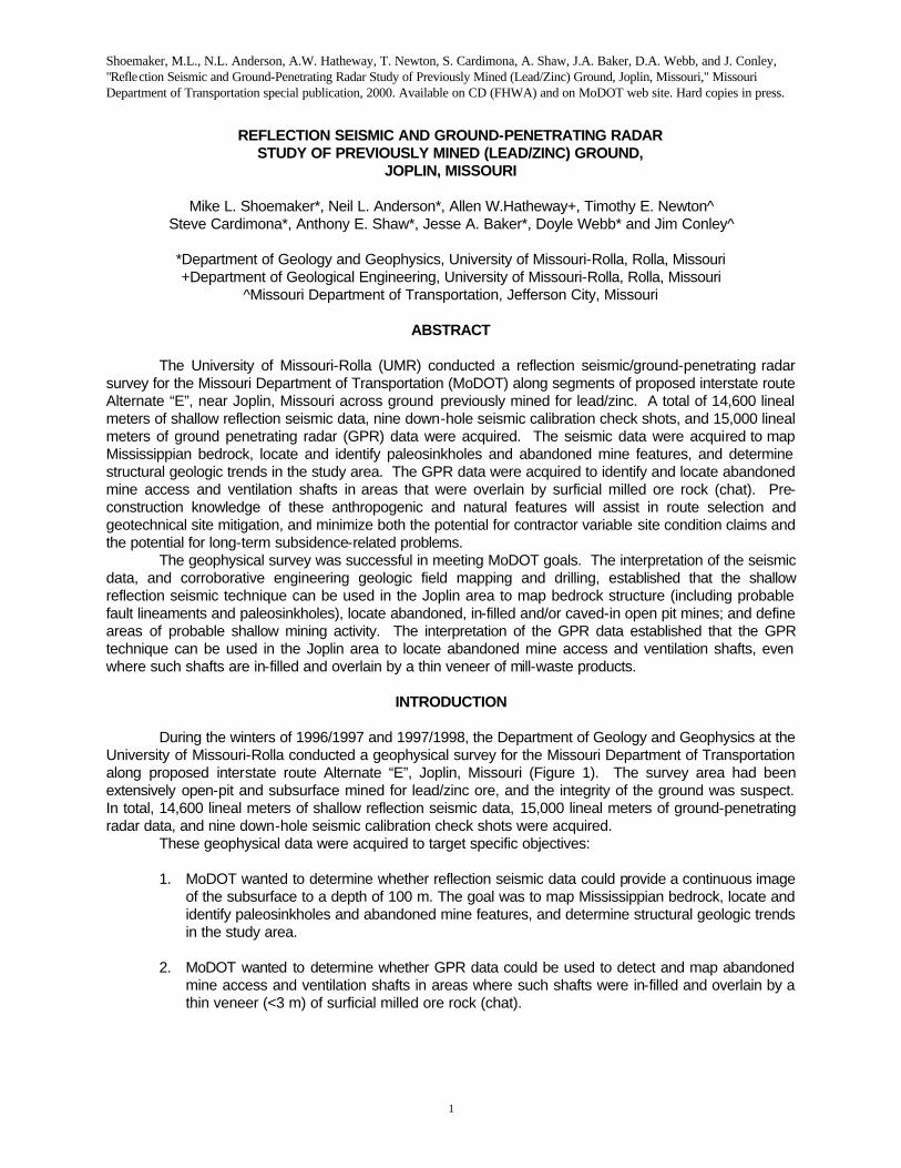
Figure 1: Map of the tri-State Lead-Zinc District. Significant geologic features and areas that have been extensively mined are highlighted. The interstate route Alternate “E” study area is located immediately to the southeast of the city of Joplin.
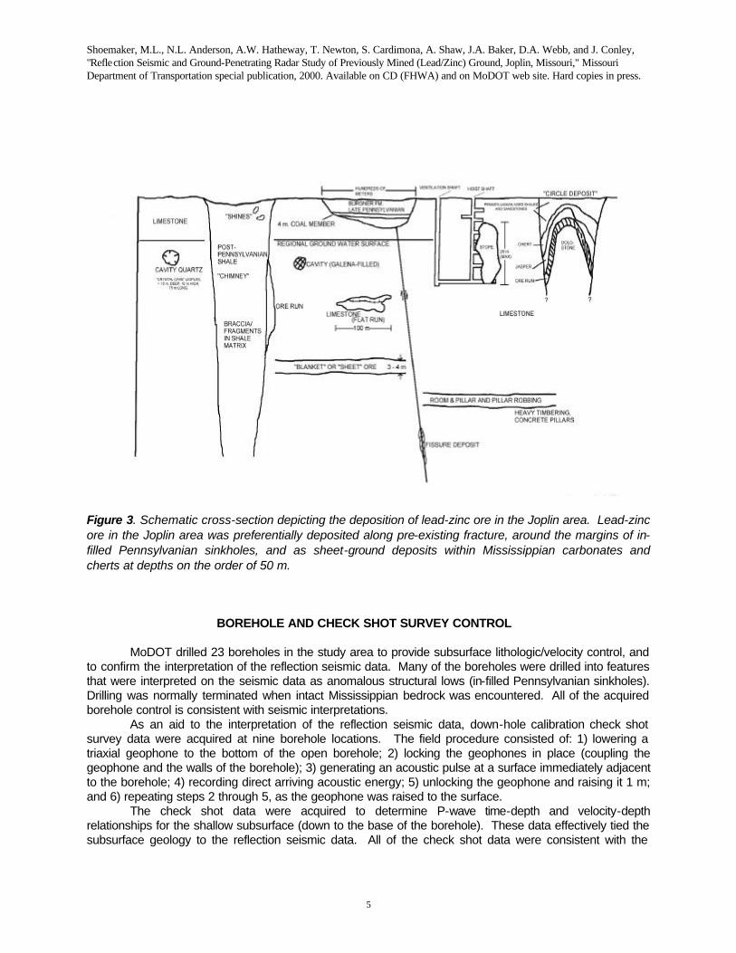
Lead/zinc ore in the Joplin area was preferentially deposited along pre-existing near-vertical joints or faults, along the margins of the Pennsylvanian sinkholes, and as sheet ground deposits within the Mississippian host rocks at depths on the order of 50 m (Hatheway et al., 1998; Figure 3). The sinkhole
Shoemaker, M.L., N.L. Anderson, A.W. Hatheway, T. Newton, S. Cardimona, A. Shaw, J.A. Baker, D.A. Webb, and J. Conley, "Reflection Seismic and Ground-Penetrating Radar Study of Previously Mined (Lead/Zinc) Ground, Joplin, Missouri," Missouri Department of Transportation special publication, 2000. Available on CD (FHWA) and on MoDOT web site. Hard copies in press.
3
and near-surface joint/fault zone ores are shallower and were recovered first (1850-1900) using either interconnected shafts or open-pit mining techniques. The sheet ground deposits are deeper and were mined later (1900-1950) using room-and-pillar methods. Typically, these mines were abandoned without mitigation and were often later robbed of ground support, thereby now constituting potential highway and/or construction hazards.
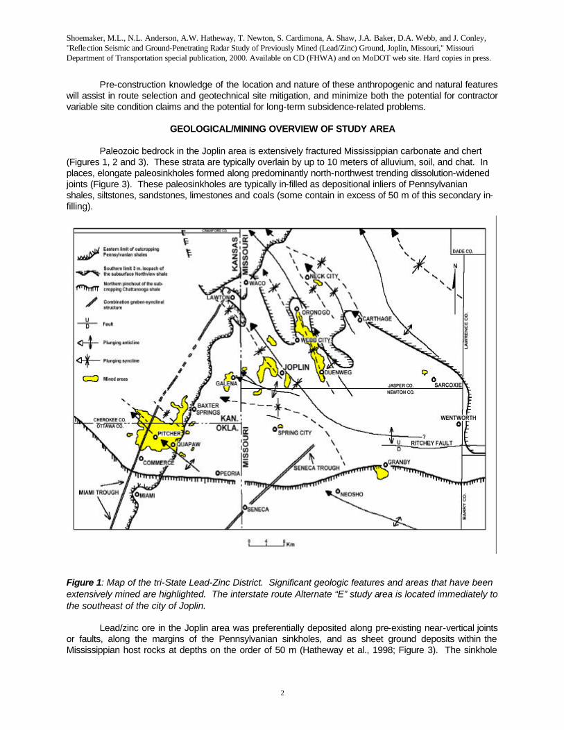
Figure 2: Stratigraphic table for the tri-State Lead-Zinc District. In the interstate route Alternate “E” study area, Mississippian Boone Formation bedrock is overlain by a veneer of soil and milled rock (chat), and localized pockets of residual Pennsylvanian-aged strata. Lead-zinc ore in the Joplin area
Shoemaker, M.L., N.L. Anderson, A.W. Hatheway, T. Newton, S. Cardimona, A. Shaw, J.A. Baker, D.A. Webb, and J. Conley, "Reflection Seismic and Ground-Penetrating Radar Study of Previously Mined (Lead/Zinc) Ground, Joplin, Missouri," Missouri Department of Transportation special publication, 2000. Available on CD (FHWA) and on MoDOT web site. Hard copies in press.
4
was preferentially deposited along pre-existing near-vertical shear zones, around the margins of in-filled Pennsylvanian-aged karstic sinkholes, and as sheet-ground deposits within Mississippian carbonates and cherts at depths on the order of 50 m below present topography.
From the perspective of a highway engineer, there are three principal types of abandoned-mine hazards in the study area. These are associated with the shallow mines that employed interconnected shafts, the shallow open-pit mines, and the deeper room-and-pillar mines that employed access and ventilation shafts.
1. Shallow mines that employed interconnected shafts that were not properly in-filled when abandoned, represent highway hazards for two reasons. First, open shafts could collapse under the new loads, resulting in incremental to catastrophic surface subsidence. Additionally, the open works of these abandoned shafts could provide vertical conduits for contaminant-bearing runoff and could also bring about the progressive “washout” of fine-grained sediment beneath the highway sub-base. (As noted previously, shallow mining activities were focused about the margins of Pennsylvanian sinkholes.) 2. The abandoned and in-filled open pit mines represent sites of potential gradual to catastrophic subsidence for two reasons. First, their non-engineered in-filling material is under-compacted and could consolidate and settle when loaded. Second, improperly abandoned shafts may also extend outward from the open-pit mine into the adjacent strata, and cause additional gradual to catastrophic surface subsidence. 3. Improperly-abandoned access and ventilation shafts to the deeper room-and-pillar mines pose subsidence hazards because of the presence of void space and under compacted fill. They also could provide vertical conduits for surface runoff and facilitate the progressive “washout” of fine-grained sediment beneath the highway. The deeper room and pillar mines themselves are not considered to be a significant risk due to the likelihood that natural upward-failing back (roof) strata would choke-up by bulking and therefor would prevent significant collapse-related surface subsidence.
Shoemaker, M.L., N.L. Anderson, A.W. Hatheway, T. Newton, S. Cardimona, A. Shaw, J.A. Baker, D.A. Webb, and J. Conley, "Reflection Seismic and Ground-Penetrating Radar Study of Previously Mined (Lead/Zinc) Ground, Joplin, Missouri," Missouri Department of Transportation special publication, 2000. Available on CD (FHWA) and on MoDOT web site. Hard copies in press.
5
Figure 3. Schematic cross-section depicting the deposition of lead-zinc ore in the Joplin area. Lead-zinc ore in the Joplin area was preferentially deposited along pre-existing fracture, around the margins of in-filled Pennsylvanian sinkholes, and as sheet-ground deposits within Mississippian carbonates and cherts at depths on the order of 50 m.
BOREHOLE AND CHECK SHOT SURVEY CONTROL
MoDOT drilled 23 boreholes in the study area to provide subsurface lithologic/velocity control, and to confirm the interpretation of the reflection seismic data. Many of the boreholes were drilled into features that were interpreted on the seismic data as anomalous structural lows (in-filled Pennsylvanian sinkholes). Drilling was normally terminated when intact Mississippian bedrock was encountered. All of the acquired borehole control is consistent with seismic interpretations.
As an aid to the interpretation of the reflection seismic data, down-hole calibration check shot survey data were acquired at nine borehole locations. The field procedure consisted of: 1) lowering a triaxial geophone to the bottom of the open borehole; 2) locking the geophones in place (coupling the geophone and the walls of the borehole); 3) generating an acoustic pulse at a surface immediately adjacent to the borehole; 4) recording direct arriving acoustic energy; 5) unlocking the geophone and raising it 1 m; and 6) repeating steps 2 through 5, as the geophone was raised to the surface.
The check shot data were acquired to determine P-wave time-depth and velocity-depth relationships for the shallow subsurface (down to the base of the borehole). These data effectively tied the subsurface geology to the reflection seismic data. All of the check shot data were consistent with the
Shoemaker, M.L., N.L. Anderson, A.W. Hatheway, T. Newton, S. Cardimona, A. Shaw, J.A. Baker, D.A. Webb, and J. Conley, "Reflection Seismic and Ground-Penetrating Radar Study of Previously Mined (Lead/Zinc) Ground, Joplin, Missouri," Missouri Department of Transportation special publication, 2000. Available on CD (FHWA) and on MoDOT web site. Hard copies in press.
6
interpretation of the reflection seismic data and the applied stacking velocities used to correct normal moveout during seismic data processing.
REFLECTION SEISMIC PROFILING
The reflection seismic data were acquired using a 24-channel Bison engineering seismograph with
roll-a-long capabilities, single channel 40 Hz geophones, and an Elastic Wave Generator weight drop source. A source, receiver and near-offset interval of 3 m was generally employed. The weight drop source was impacted 6 to 14 times per shot record, dependent upon visual inspection of the incoming background noise on the shot gathers. Elevation control was acquired for each source and geophone location.
The reflection seismic data were processed on a pentium PC using WINSEIS (Kansas Geological Survey, 1996). A common processing sequence was applied to the data consisting of:
1. identification of reflection from bedrock, 2. muting of energy that arrived prior to pre-bedrock event, 3. muting of first breaks and ground roll, 4. resorting the shot-gathered traces into common midpoint (CMP) gathers, 5. applying elevation corrections, 6. performing velocity analysis for each line, 7. calculating and applying surface consistent statics, 8. application of normal moveout (NMO) corrections (muting to exclude excessively stretched
data), 9. stacking the NMO corrected data, 10. applying residual statics, and restacking statically corrected data, and 11. bandpass filtering.
Shoemaker, M.L., N.L. Anderson, A.W. Hatheway, T. Newton, S. Cardimona, A. Shaw, J.A. Baker, D.A. Webb, and J. Conley, "Reflection Seismic and Ground-Penetrating Radar Study of Previously Mined (Lead/Zinc) Ground, Joplin, Missouri," Missouri Department of Transportation special publication, 2000. Available on CD (FHWA) and on MoDOT web site. Hard copies in press.
7
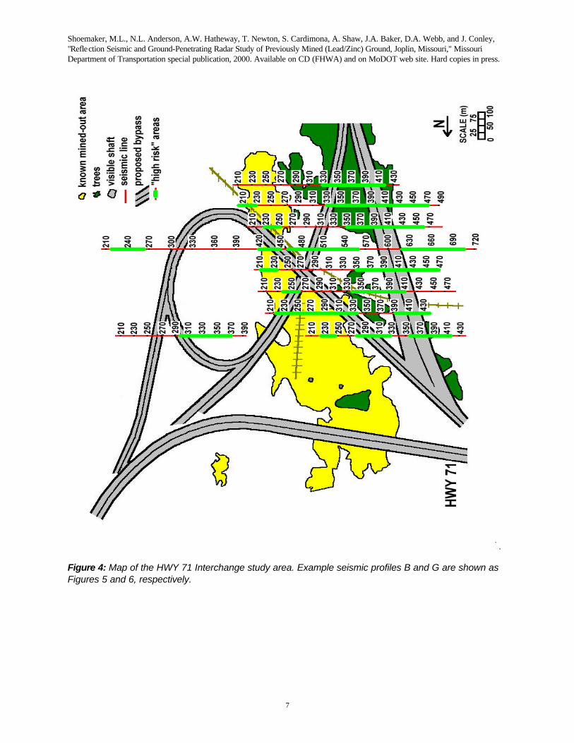
Figure 4: Map of the HWY 71 Interchange study area. Example seismic profiles B and G are shown as Figures 5 and 6, respectively.
Shoemaker, M.L., N.L. Anderson, A.W. Hatheway, T. Newton, S. Cardimona, A. Shaw, J.A. Baker, D.A. Webb, and J. Conley, "Reflection Seismic and Ground-Penetrating Radar Study of Previously Mined (Lead/Zinc) Ground, Joplin, Missouri," Missouri Department of Transportation special publication, 2000. Available on CD (FHWA) and on MoDOT web site. Hard copies in press.
8
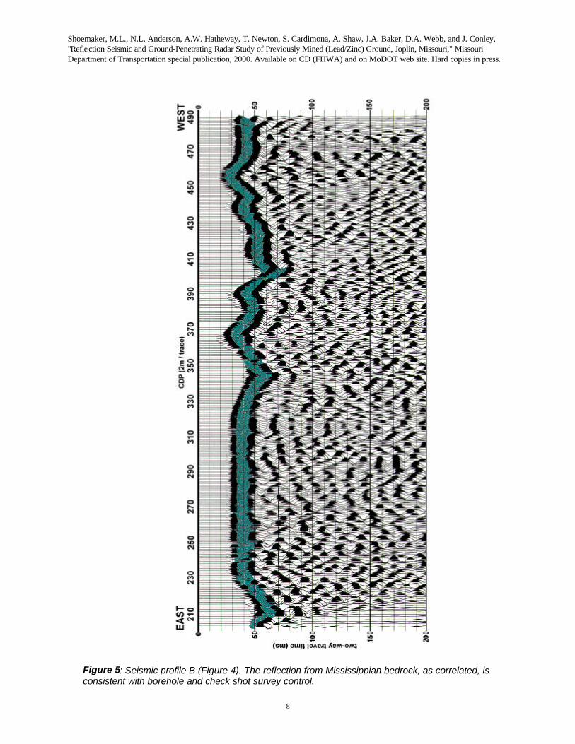
Figure 5: Seismic profile B (Figure 4). The reflection from Mississippian bedrock, as correlated, is consistent with borehole and check shot survey control.
Shoemaker, M.L., N.L. Anderson, A.W. Hatheway, T. Newton, S. Cardimona, A. Shaw, J.A. Baker, D.A. Webb, and J. Conley, "Reflection Seismic and Ground-Penetrating Radar Study of Previously Mined (Lead/Zinc) Ground, Joplin, Missouri," Missouri Department of Transportation special publication, 2000. Available on CD (FHWA) and on MoDOT web site. Hard copies in press.
9
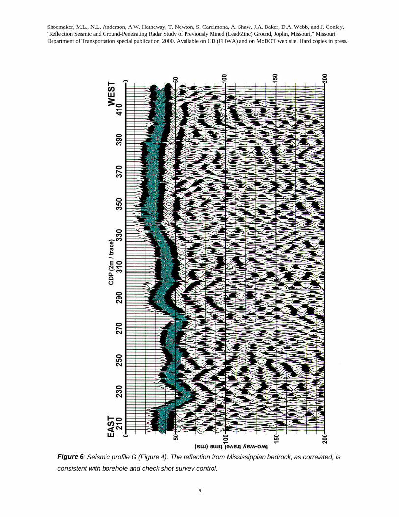
Figure 6: Seismic profile G (Figure 4). The reflection from Mississippian bedrock, as correlated, is
consistent with borehole and check shot survey control.
Shoemaker, M.L., N.L. Anderson, A.W. Hatheway, T. Newton, S. Cardimona, A. Shaw, J.A. Baker, D.A. Webb, and J. Conley, "Reflection Seismic and Ground-Penetrating Radar Study of Previously Mined (Lead/Zinc) Ground, Joplin, Missouri," Missouri Department of Transportation special publication, 2000. Available on CD (FHWA) and on MoDOT web site. Hard copies in press.
10
INTERPRETATION
The shallow reflection seismic survey data were acquired to identify and spatially locate both
natural and anthropogenic (abandoned mine) features that constitute potential construction or operational and maintenance problems or hazards. More specifically, the MoDOT wanted to: 1) map Mississippian bedrock structure; 2) identify major bedrock fault and/or fracture zones; 3) locate paleo (generally Pennsylvanian) sinkholes; 4) locate abandoned and in-filled open-pit lead/zinc mines; and 5) identify areas of probable shallow historic mining activity (generally about periphery of Pennsylvanian sinkholes. The intent was to transfer these geophysical interpretations and resulting hazards targets onto MoDOT compilations of archival mine location maps as an aid to MoDOT engineers involved in route planning, hazards assessment and site mitigation.
Example reflection seismic profiles from the HWY 71 Interchange section (Figure 4) of the Joplin study area are presented as Figures 5 and 6. The reflection from Mississippian bedrock, as correlated across each profile, is consistent with borehole and check shot survey control. Limited borehole control in the area indicates bedrock depth variations of between 3 m and 33 m. (The depth to bedrock from two-way travel times along the seismic profiles indicate depth variations of between 5 m and 35 m.)
The prominent structural features at Mississippian bedrock level trend NNW and can be correlated across the suite of seismic profiles (Figures 4, 5 and 6). The structural lows are elongate, appear to be bounded by fault scarps, and are interpreted as Pennsylvanian karst-collapse features (paleo sinkholes). These in-filled sinkholes developed along solution widened fractures, and are prospective sites for shallow mining activity. As such, they have been denoted as high risk areas (Figure 4). Areas where bedrock is structurally elevated are less likely to have been the site of extensive shallow mining and are denoted as low risk. These reflection seismic data are of utility to the Transportation Department for several reasons:
1) Depth to bedrock is highly variable at these sites (5-35 m). Knowledge of these variations and sometimes-associated structural geologic trends will affect the placement of foundation elements. 2) Pre-existing paleo-fracture zones, some of which are believed to have been widened by karstic dissolution, may provide vertical conduits for downward percolating water, leading to the progressive “wash out” (piping) of fine-grained sediment beneath roadways and resulting in gradual subsidence. Further dissolution widening of these fractures could result in catastrophic collapse, although this advanced scenario is far less likely as contemporary dissolution activity during the life of most roadways will be negligible in an engineering sense. 3) The Pennsylvanian-aged sinkholes are and were recognized after about 1910 as highly probable locations of ore, and should be considered to harbor improperly closed mine shafts. Improperly-filled shafts could collapse under the additional loads of new roadway structures, and therefor represent both short-term construction and long term highway hazards. Additionally, shafts could serve as conduits for downward percolating water, bearing the incidental contaminants from roadway traffic.
GROUND-PENETRATING RADAR PROFILING
A Geophysical Survey Systems, Inc., Subsurface Interface Radar unit (SIR-8) equipped with a
500 MHz monostatic antenna was used to acquire a total of 15,000 lineal meters the ground-penetrating radar data (Baker et al., 1998). The data were acquired as suites of parallel GPR profiles (spaced at 1.5 m) in order to locate mine access and ventilation shafts. The sampling interval was 30 scans/foot. The trace length was 100 ns, providing for depth penetration on the order of 5 m. The GPR data was processed
Shoemaker, M.L., N.L. Anderson, A.W. Hatheway, T. Newton, S. Cardimona, A. Shaw, J.A. Baker, D.A. Webb, and J. Conley, "Reflection Seismic and Ground-Penetrating Radar Study of Previously Mined (Lead/Zinc) Ground, Joplin, Missouri," Missouri Department of Transportation special publication, 2000. Available on CD (FHWA) and on MoDOT web site. Hard copies in press.
11
on a pentium PC using RADAN (Geophysical Services Systems, 1995). Our processing routine consisted of trace normalization, followed by application of vertical gain, horizontal filtering, and vertical filtering.
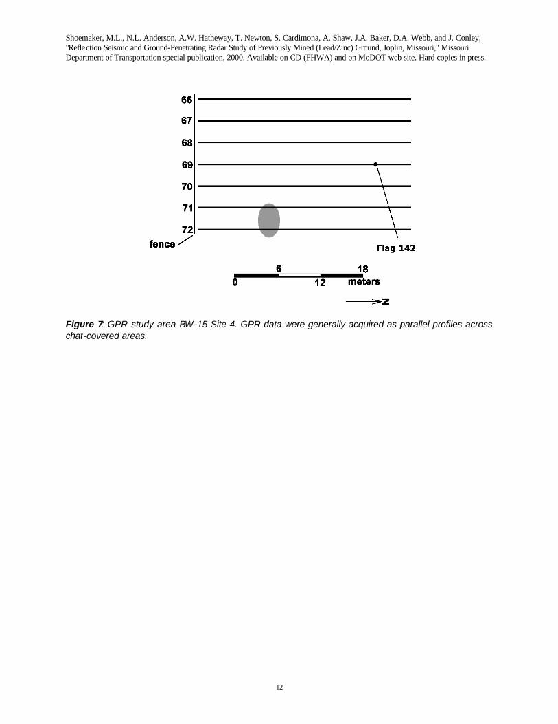
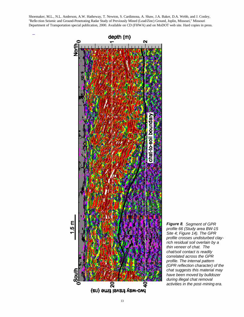
A segment of an example processed ground-penetrating radar profile from study area BW-15 Site 4 (Figure 7) is displayed as Figure 8. These GPR profiles cross undisturbed clay-rich residual soil overlain by a thin veneer of chat. The chat/soil contact is easily identified and correlated across the GPR profile. The chat is comprised of small, flake-like fragments of crushed and milled carbonate rock. The GPR image of the chat is characterized by an internal pattern that is consistent with cross-bedding, which suggests that this material may have been moved about by a bulldozer, as much of the chat has been illegally gathered and removed for use as local fill and driveway/roadway surfacing. The latter has been a fact of considerable concern to the U.S. Environmental Protection Agency (Region VIII, Kansas City, KS) and the Hazardous Waste Program of the Missouri Department of Natural Resources. The subject highway project lies within the bounds of the SUPERFUND National Priority Site, designated for environmental remediation.
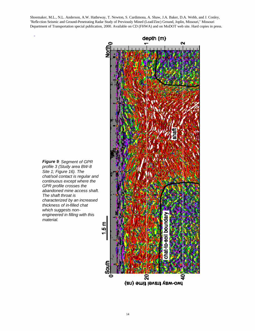
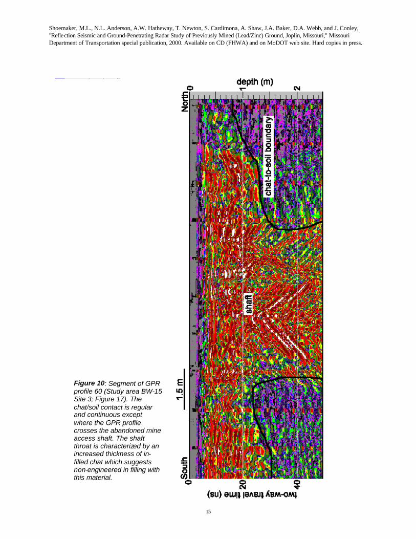
Segments of example ground-penetrating radar profiles from study area BW-8 Site 1 and BW-15 Site 2 are shown as Figures 9 and 10, respectively. These profiles image in-filled mine access shafts. The thin veneer of chat overlying the original ground surface is characterized by internal cross-bedding. The chat/soil contact is identifiable and easily correlated across the GPR profile. This surface is regular in character and continuous except where the GPR profile crosses the throat of an abandoned mine access shaft. The mine shaft is characterized by an increased thickness of chat, which is consistent with area evidence that many abandoned shafts were in-filled with chat, during the illegal removal of that material.
CONCLUSIONS
The interpretations of the reflection seismic data establish that this tool can be used, in the Joplin
area, to map Mississippian bedrock and bedrock related features such as faults and paleosinkholes, and to delimit areas of probable historic mining activity. A recognition of these subsurface conditions is important because fault and shear zones, sinkholes, and improperly-abandoned mines constitute potential highway and/or construction hazards. Pre-construction knowledge of subsurface conditions will facilitate route planning and remediation efforts, and reduce short term construction and long term maintenance costs. Additionally, variations in subsurface conditions should be provided to the contractor as the basis for informed actions incidental to construction.
The interpretation of the GPR data establish that this technique can provide confirmatory evidence of abandoned mine access and ventilation shafts in areas that are overlain by chat. The chat is characterized by cross-bedding in the GPR profiles and can be readily differentiated from the underlying soil. The chat/soil interface is regular in character and continuous except where the GPR profile crosses the mine access or ventilation shafts. The mine shafts are characterized by an increased thickness of chat, which is consistent with the idea that many of the previously-open abandoned shafts were in-filled with chat. The act of in-filling is believed to have occurred entirely after the cessation of mining and was related to the illegal traffic in the lead/zinc-bearing mine waste. These improperly abandoned mine shafts constitute potential short-term construction and long-term highway hazards. Pre-construction knowledge of these features would assist in route selection and geotechnical site mitigation, and minimize both the potential for contractor variable site condition claims and the potential for long-term subsidence-related problems.
Shoemaker, M.L., N.L. Anderson, A.W. Hatheway, T. Newton, S. Cardimona, A. Shaw, J.A. Baker, D.A. Webb, and J. Conley, "Reflection Seismic and Ground-Penetrating Radar Study of Previously Mined (Lead/Zinc) Ground, Joplin, Missouri," Missouri Department of Transportation special publication, 2000. Available on CD (FHWA) and on MoDOT web site. Hard copies in press.
12
Figure 7: GPR study area BW-15 Site 4. GPR data were generally acquired as parallel profiles across chat-covered areas.
Shoemaker, M.L., N.L. Anderson, A.W. Hatheway, T. Newton, S. Cardimona, A. Shaw, J.A. Baker, D.A. Webb, and J. Conley, "Reflection Seismic and Ground-Penetrating Radar Study of Previously Mined (Lead/Zinc) Ground, Joplin, Missouri," Missouri Department of Transportation special publication, 2000. Available on CD (FHWA) and on MoDOT web site. Hard copies in press.
13
Figure 8. Segment of GPR profile 66 (Study area BW-15 Site 4; Figure 14). The GPR profile crosses undisturbed clay-rich residual soil overlain by a thin veneer of chat. The chat/soil contact is readily correlated across the GPR profile. The internal pattern (GPR reflection character) of the chat suggests this material may have been moved by bulldozer during illegal chat removal activities in the post-mining era.
Shoemaker, M.L., N.L. Anderson, A.W. Hatheway, T. Newton, S. Cardimona, A. Shaw, J.A. Baker, D.A. Webb, and J. Conley, "Reflection Seismic and Ground-Penetrating Radar Study of Previously Mined (Lead/Zinc) Ground, Joplin, Missouri," Missouri Department of Transportation special publication, 2000. Available on CD (FHWA) and on MoDOT web site. Hard copies in press.
14
Figure 9: Segment of GPR profile 3 (Study area BW-8 Site 1; Figure 16). The chat/soil contact is regular and continuous except where the GPR profile crosses the abandoned mine access shaft. The shaft throat is characterized by an increased thickness of in-filled chat which suggests non-engineered in filling with this material.
Shoemaker, M.L., N.L. Anderson, A.W. Hatheway, T. Newton, S. Cardimona, A. Shaw, J.A. Baker, D.A. Webb, and J. Conley, "Reflection Seismic and Ground-Penetrating Radar Study of Previously Mined (Lead/Zinc) Ground, Joplin, Missouri," Missouri Department of Transportation special publication, 2000. Available on CD (FHWA) and on MoDOT web site. Hard copies in press.
15
Figure 10: Segment of GPR profile 60 (Study area BW-15 Site 3; Figure 17). The chat/soil contact is regular and continuous except where the GPR profile crosses the abandoned mine access shaft. The shaft throat is characterized by an increased thickness of in-filled chat which suggests non-engineered in filling with this material.
Shoemaker, M.L., N.L. Anderson, A.W. Hatheway, T. Newton, S. Cardimona, A. Shaw, J.A. Baker, D.A. Webb, and J. Conley, "Reflection Seismic and Ground-Penetrating Radar Study of Previously Mined (Lead/Zinc) Ground, Joplin, Missouri," Missouri Department of Transportation special publication, 2000. Available on CD (FHWA) and on MoDOT web site. Hard copies in press.
16
REFERENCES Baker, J.A., Shoemaker, M.L., Anderson, N.L., Hatheway , A.W., Newton, T.E. and Conley, J.,1998,
Ground-penetrating radar study of previously mined (lead/zinc) ground in Joplin, Missouri, in Anderson, N.L., Cardimona, S., and Newton, T., Editors, Highway Applications of Engineering Geophysics with an Emphasis on Previously Mined Ground: Missouri Department of Transportation Special Publication, 136-142.
Geophysical Services Systems, 1995, Radan For Windows Operating System: Geophysical Services Systems Inc. publication, NH, 194 p.
Hatheway, A.W., Newton, T.E., Anderson, N.L., and Shoemaker M.L., 1998, Characterization methodology for abandoned mined ground as a highway siting constraint, Joplin, Missouri, in Anderson, N.L., Cardimona, S., and Newton, T., Editors, Highway Applications of Engineering Geophysics with an Emphasis on Previously Mined Ground: Missouri Department of Transportation Special Publication, 105-123.
Kansas Geological Survey, 1996, Winseis User’s Manual: Kansas Geological Survey publication: Kansas Geological Survey , KS, 133 p.
Shoemaker, M.L., Anderson, N.L., Shaw, A.E., Baker, J.A., Hatheway A.W., Newton, T.E. and Conley, J., 1998, Reflection seismic study of previously mined (lead/zinc) ground, Joplin, Missouri, in Anderson, N.L., Cardimona, S., and Newton, T., Editors, Highway Applications of Engineering Geophysics with an Emphasis on Previously Mined Ground: Missouri Department of Transportation Special Publication, 124-135.
Theil, J., 1942, Geological maps showing mining and mineralization areas of the Joplin area: Missouri Geological Survey and Water Resources, 4 p. text and 6 geologic maps.