Embed Size (px)
Citation preview

DISCUSSION 3 79
Punagarh volcanism and Initial phase of Malani On the other hand, a parallel rift generated on the head volcan~sn~ However, the Punagarh volcanism took o f the sample plume was lor~g l~ved in wh~ch outpouring
place ~n a reactivated rlft (Pall lineament) probably of vast quantities of lavas took place (Malanl at the per~phery of plume and did not last long magrnatlsm)
References
BANERIEE, A K a l~d SINGH, S P (1978) P~llow lava in Pa11 d~stnct, Rajasthan GSI News, v 9, No 2
BHUSHAN, S K (2000) Neoproterozolc maglnat~sm of the Malanl Igneous Su~te, We5tem Rajasthan, Indla Geol Sum Indla, Spec Publ No 55, pp 319-332
BHUSHAN, S K (2000) Malan~ Rbyol~tes - A Revlew Gondwana Res , v 3, pp 65-77
BOSE, U (1989) Correlation problems of the Proterozoic strar~graphy of Rajasthan Indian M~nerals, v 43, pp 183- 193
CHORE, S A and MOHANTY, M (1 988) Strat~graphy and tectonrc settings of the Tians-Aravall~ Neoproterozoic sequences in Rajasthan Jour Geol Soc India, v 5 1, pp 57-68
CHOUDHARY, A K , GOPALAN, K and SASTRY, C A (1984) Present status of the geochronology of the Precambrian rocks of Rajasthan Tectonophys~cs, v 105, pp 13 1 - 140
COULSON, A L ( I 933) The Geolvgy of the S~rohl State, Rajasthan Mem Geol Sum Ind~a, v 63, I66p
CRAWFORD, A R and COMPSTON, W (1970) The age of the
Vindhyan system of Pen~nsular I n d ~ a Quat Geol Soc London, v 125, pp 35 1-372
GATI-IANIA, R C , CHOWUE, M P, GOSH, S P and CHANDRASHEKIIRAN, V ( 1984) A report on systeniatic geologrcal mapping of the Malam Igneous Sulte In parts of Bam~er, Jodhpur, Jalore and Pall distrrcts, Rajasthan Unpubl Geol Surv India Rept for FS 1981-82
LA TOUCHE, T H D (1 902) Geology of Western Rajputana Mem Geol Surv Indla, v 35, 1 16p
RACULT, P ( 1 933) Geology of S~rohl State Mem Geal Surv India, v 63(1), 1 17p
ROY, A B and J A K H A R , S R (2002) Geology of Rajasthan (NW Ind~a) Screntlfic Publ~shers, Jodhpur, 421p
SHYAM NARAIN (1988) Report on base metal lnvestrgat~on in Punagarh group of rocks, Pall district, Rajasthan Unpublrshed Geol Surv India Report
SINGH, S P (1983) P~llow lavas from Delhl Supergroup near Barnbholal, Pall district, Rajasthan Jour Geol Soc Ind~a, v 24, pp 208-2 11
SEISMOGEOLOGY OF KUTCH AND ADJOINING REGION WITH SPECIAL REFERENCE TO 26th JANUARY 2001 EARTHQUAKE IN THE VICINITY OF BACHAU, GUJARAT by K.S Misra, R. Bhutan1 and R. Sonp Jour Geol Soc India, Aug 2004, v 64, pp. 153-164
R.V. Karanth, Department ofGeology, Faculty of Sc~ence, M S Univers~ty of Baroda, Vadodara - 390 002, Email: r-v-karanthayahoo co In, comments
Lineaments, Indeed, have great s~gnlfrcance In interpreting varlous geolog~cal features and problems Remote senslng through satellite Imagery as well as topographic sheet is considered as a conven~ent method of rnapp~ng lineaments formed on account of traces o f
bedding, master jornts, faults, dykes and other geolog~cal structures The lineaments traced, however, have to be confirmed by the ground real~ty In the paper under d~scusslon Mlsra et al have traced several 'major' faults 'remo fely sensed data partrcularly us rng IRS Images on 1 250 000 and I 50 000 scale' (p 163) Several
ENE- WS W, NE-S W, E- W, N W-SE 'malor actwe' faults have been traced in western India part~cularly In the region of Kachchh (Figs 2,4 and 6 of Misra et al 2004) Us~ng this data, se~smology of Kachchh and adjo~nlng region has been interpreted by the authors Espec~ally NW-SE and curvilinear ENE-WSW faults dominate In the reglon of Kachchh according to the authors (Flg 2, op a t ) The NW-SE, NE-SW major faults have been traced In to the Great Indian (Thar) Desert in the northern reg1011 These faults conveniently cut across the geolnorphlc divide, Nagar Parkar rtdge, w h ~ c h rncrdentally IS, suppose to be the northern I~rnlt of the Kachchh rift Accord~ng to the authors the Kachchh Mainland Fault along whrch five devastating earthquake epicenters have been located, extends from Lakhpat through Bhachau-Lakadya to southeastward and termmates near Morb~ (Fig 4)
JOUR GEOL SOC INDIA, VOL 66 SEPT 2005

3 80 DISCUSSION
Extensive field mapping by the ONGC team lead by Biswas ( 3 987; Figs. 2, 4 and 5 ) reveals only E-W tectonic trends in Kachchh (Nagar Parkar- Tharad ridge/fault, Island Belt ridge/fault, Wagad ridge/fault, Mainland ridgdfault and North Kathiawar fault). But for the Median High no major N-S and other cross cutting lineaments have been recognised by him in Kachchh. The latter represents only the Mesozoic sedimentary basinal configuration, controlling the facies and thickness of Mesozoic sediments, but does not represent a surficial fault or ridge.
Signatures of major lineaments are expected to be represented conspicuously on the surface such as E-W trending Nagar Parkar ridge/fault, Island Belt ridgdfault, Wagad ridge/fault and Kachchh Mainland ridge/fault in the form of hill rangeslridges and lithological variations. The authors should explain in which form the NW-SE major lineaments (as spelt out by them "major faults") in Kachchh are expressed in the field. It is difficult to understand how all these faults cut through Kachchh Mainland Fault and Katrol Hill Range Fault without disturbing them. Some of the major faults are shown to extend into the dunes of Thar Desert (Fig.2). Are the epicenters of >6 M earthquakes 1 to 5 placed at the intersections of the major faults or major faults are drawn to make them intersect Kachchh Mainland Fault at the said epicenters? Locating the epicenters as well as determining the magnitude of earthquakes that took place prior to the 20th century (non-instrumental era) could not have been very precise.
The authors have not explained why the Kachchh Mainland Fault has been extended by turning it in SE direction up to Morbi. Extending the Kachchh Mainland Fault into Morbi, Saurashtra has never been considered by any author earlier. Such a feature is required to be substantiated adequately. Some of the NW -SE faults are seen extending from Kachchh Mainland deep into Saurashtra (Fig.2). It is doubtful whether such lineaments with geological or geomorphological expression exist in Saurashtra (Karanth and Sant, 1995).
The 'lzorseshoe' pattern of the a3ershock (Fig.6 of Misra et al. 2004) appears to have been over-dramatised. How this 'horseshoe' has been considered by the authors? The isoseismal lines modified after Ravi Shanker and Pande (2001; Fig.1, p.205) appear to have been modified into a horseshoe shape. For the sake of convenience. In fact, at the time of main shock Bhuj and surrounding that lie out side the western part of horseshoe was affected much more than Rapar, Desalpar and Lodrani that lie within the horseshoe's eastern part.
If lineamentslfaults can be drawn just by remote sensing techniques, is there any necessity of field geologists, that
too to work in a semiarid region which is known to be climatically unfavourable with scanty vegetation and water resources? No doubt remote sensing is a very powerful tool in recognising various regional geologic structures. Nonetheless, the essentials of geology lie in the field. Seeing in field is believing!
K.S. Misra, R. Bhutani and R. Sonp, GeoIogical Survey of India, Bandlaguda, Hyderabad - 500 068, reply:
We thank Prof. Karanth for keeping alive the debate on the subject of image interpretation versus field studies. Most of the geologists have started to appreciate the importance of image interpretation and indispensability of field studies. In first paragraph the findings of the paper by Misra et al. (2004) are reproduced. In second para the classical work done by Biswas (1987) is highlighted. In the third para the exercises done by Misra et al. (2004) are commented upon. We have well demonstrated in this paper that most of the mapped lineaments are directionally parallel to either ENE-WSW trending Kutch rift or NW-SE trending Cambay structure. Figs. 3A and 3B depict typical geomorphological features generally associated with these sets of lineaments. It is suggested that interpretation of available IRS imagery and plotting of earthquake epicenters from the published data (Guha and Basu, 1993) would have convinced anyone about the repeatability or reproducibility of results, which is of prime importance in any branch of science. Casting aspersions on the work done by the authors without doing the required exercise is unwarranted and detrimental to the growth of science. In fact both NW-SE and ENE-WSW trending lineaments from Kutch and adjoining region have been published by Misra (1999) much before the 26th January 2001 earthquake. The importance of these two lineaments in seismicity of Western India has further been elaborated by Misra (2001). The extension of Kutch Mainland faults in SE direction is mapped on the basis of associated geomorphological features.
The pattern of the aftershocks and limiting lines in Fig.6 is totally misunderstood by Prof. Karanth with the isoseismal lines. The isoseismal lines are drawn by Ravi Shanker and Pande (2001) are based on the damage pattern caused by the 26th January 2001 earthquake, while Fig.6 demonstrates the epicenters of aftershocks plotted by using the USGS data with precise latitudes and longitudes. Same exercise can be simply repeated and doubts can be cleared.
It is well understood by every geologist that lineaments and faults can better be identified by interpretation of aerial photographs and satellite imagery. These can be verified in
JOUR.GEOL.SOC INDIA, VOL 66, SEPT. 2005

DISCUSSION 38 1
freld and other assoclated features can be recorded This approach does not in any way reduce the indispensability of field studles Many major basement faults such as those borderrng Kutch rlft and Cam bay structure, were responsible for the development of elongated baslns to accommodate several kilometer thick sedimentary rocks that have no pronounced field characters Thts IS because these faults have tendency to bifurcate upward and when they reach to surface the Incremental d~splacements are very mlnor (Ftg 3E) However, these rnlnor displacements can also be mapped in Quaternary sediments provlded we are looklng for them
Y. Sreedhar Murthy, Centre of Exploration Geophysics, Osmanra University, Hyderabad - 500 007 Emazl: profysm @yahoo corn, comments
The paper under dlscusslon is very interesting as it throws new light on the tectonics of this reglon The occurrence of major earthquakes and a h ~ g h seismicity in the Kutch and Saurashtra region is well known as this regton has already been classified seismically as Zone V and as such calls for detailed studies for understanding its complex geotectonlc h~story In this context, the delineation of the structural fabric and major lineaments and faults from Landsat ~rnagery and related geornorphological studles and their correlation w~th the seismicity of the region by Misra and others IS tlmely and significant
The authors have clearly brought out NW-SE, ENE-WSW to NE-SW and E-W structural trends and their correspondence with the trends of isose~smals and their ~ntexxelationshrp It IS lnterestlng to note that these mega lineaments are also reflected in the gravrty Images of India (Sreedhar Murthy, 1999, Sreedhar Murthy and Ravai, 2000) The gravlty images of Indra have not only tdentlfied all the known structures and tectonlc features but also brought out several new trends and features, which are not seen on any of the conventional geological or geophysical analogue maps A case in point whlch has a bearing on the tectonics of the Kutch region is the delrneatlon of the NW-SE trendlng linear starting from Chennal on the east coast and passing through the Proterozorc Cuddapah bas~n, Deccan traps and north of Mumbai and extending further towards N W into Saurashtra peninsula Towards east ~t also extends in to Bay of Bengal as seen from the marine gravity data The subsequent studles have clearly brought out the close correspondence of the Latur, 1993, Bhuj, 2001 and the Pondrcherry, 2001 earthquakes with t h ~ s mega lineament (Sreedhar Murthy, 2002) In fact t h ~ s mega
lineament has a varying wrdth extending over a few tens of kilometers and it must have been reactivated many several times in the geological past The Kukdl-Ghod lrneament zone (Fig 1 of Misra et a1 2004) appears to be a part of thls mega lrneament
Another feature whlch has relevance to the present study is the Raval Line (Sreedhar Murthy, 2002) The gravity lmages have brought out a N-S trending linear starting from Karakorum region and passlng through Rajasthan and Gujarat and further south off west coast up to Laccadive and Chagos Islands It IS to be observed that the gas f~elds of Pakxstan and hydrocarbon bearlng structures in Rajasthan, Gujarat and the 'Bombay hlgh' and the recently dlscovered gas hydrates off Laccadive, Chagos r~dges are allgned along this lineament (Avinash Chandra, 2004) For too long In India, we have explored for hydrocarbons in the Tertiary formatrons This is baffling especially when the world over significant deposlts of hydrocarbons are known to be associated with Mesozolcs Startlng wrth the discovery of Barmer find In Rajasthan in 1998-99, slzeable hydrocarbon deposits are dlscovered in Mesozo~c formations in Indla during the last five years The hydrocarbon deposits dlscovered in Gujarat call for a detailed study of the lnterrelationshlp between the different fauIt systems and thelr correlation, ~f any, with such systems In this context, it 1s felt that the study of Misra and others (2004) could have thrown some light on the relatlve antiquity of different fault sets so that one can ascertain wh~ch set is relevant for oil exploration
The preferent~al propagation of sersmic energy of the Bhuj Earthquake and the assoclated damage In the far- flung areas and the associated after shock activlty in the NE-SW direction is well brought out by the authors T h ~ s study under reference strengthens the concept of wave guides in the propagation of seisrn~c waves, which probably explains the fact that Bhuj Earthquake was feIt in Chennai while not so in Hyderabad, which IS farther north of this lineament This aspect and its implications to the region need to be further investigated by the seismolog~sts
The structural trends inferred by Misra and others are also reconfirmed In an ~ndependent study based on the analysxs of detailed gravity and lineament data as reported by D C Mishra and others of NGRI (Mishra et a1 2001) It 1s in this background the observation "It IS time to draw up multi-discrplinary and mutil-institubonal programmes aimed at garnlng a better understanding of the infrnrte variety presented by planet earth" (B P Radhakrishna, 2004) assumes great srgnrficance and underl~nes the importance of ~ntegrated geoscient~fic studies in India
JOUR GEOL SOC INDIA VOL 66, SEF'T 2005
3 82 DISCUSSION
K.S. Misra, R. Bhutani and R. Sonp, Geological Survey of Indla, Bandlaguda, Hyderabad - 500 068, reply
We are glad to note that Prof Y. Sreedhar Murthy has found our paper (Misra et a1 2004) very interesting, tlmely and significant The correspondence of mega lineamel~ts and ~soseismals brought out by our work is corroborated with the trends observed by him ~n the gravity lmages is really very satisfylrig Slmilar findings from the gravity data and support in favour of mega l~nearnents by Mishra et a1 (2001 ) is also very s~gnrficant In fact, all the mega lineaments and faults have directional parallel~sm with the major geological structures of the peninsular shield (Misra, 2001) An intimate tectonlc reTat~onshlp between vertical faulting, development of baslns, sedimentation, volcanism and dyke emplacement has been brought out recently by Mlsra (2004) In this paper ~t has been emphasized as suggested by Prof Murthy that exploration of Mesozotc hydrocarbons below the Deccan and assoc~ated volcanrcs IS very much requlred
The support our work has got from the concept of wave guides is also very encouraging M~sra (2004) illustrated that the damage pattern IS controlled by mega lineaments and faults Attenuation of the seismic waves wh~le crosstng major geolog~cal structures and channelization of s e ~ s ~ n l c energy along them IS very s~gnificant contribution I agree with the conc lud~ng remarks of Prof Murthy that niult~dlsciplinary approach for better understanding of geological structures IS very much needed
(3)
A.V. Phadke, Flat No 108, Devdatta Krlpa Co-op Hsg Society, 4514 Karvenagar, P 0 Navasahyadn, Pune - 4 1 1 052 Email.. avphadkeapn2 vsnl net In, comments
My coi~gratulat~ons to Dr K S Mlsra and associates of the Geological Survey of India for the long awaited distlnct and understandable relat~onship between the geological structures and seismic~ty of Kutch reglon The reg~onal tectonlc framework presented by the authors needs appreciation, slnce the geologrcal s tud~es by different workers in localized areas have not been successful In answering the questions related to the se~sniic~ty of Kutch reglon By carrylng out simple exercises of interpreting the faults with neotectonic movements and plotttng the epicenters of earthquakes and aftershocks of 261h January, 2001 earthquake, the authors have clearly brought out the relationship between them and rightfully suggested that both are the products of active tectonlsrn lnvolved in the Kutch region
It would be more in teres t~ng to understand the
relatronship between major geologlcal st1 uctures brought out by the authors, and volcanlsln in western i n d ~ a The Important quest~ons for whtch I would llke to get the answers are - where d ~ d tlie magma chamber exlst that suppl~ed the lavas for Deccan traps? Where are the major effus~ve zones and centres located? Whether these zones and centres continued outpouring of lava from the begrizl-ling to the end of volcanlsrn and d ~ d lavas travel to long d~stances such as Rajahmundry, Mandla and Rajrnahal areas? If the volcanisln is of mult~central nature 1s it worthwhrle to work on unlfied lava strat~grapl~y for the entlre Dcccan Volcanlc Province?
K.S. Misra, R. Bhutani aiid R. Sonp, Geolog~cal Survey of Indla, Bandlaguda, Hyderabad - 500 068, reply
We are happy to note that Prof. A.V. Plladke has found the work dlstinct and it has brought otrt understandable relationship between geolog~cal structures and selsrnlclty of Kutch regloll Certainly regronal study has its own advantages in understanding the seismotectonics of the area Prof Phadke has Indeed asked very pertiilent questions
concerntng Deccan volcan~sni, whlch have been engaglng the attention of geologists for over a century The repl~es to these very Important quest~ons are summed up briefly as under
1. Where did the magma chamber exist, which has supplied the lavas for Deccan traps ?
According to earller v~ews it was believed that Deccan volcanlcs have erupted from a huge iliaglna cllalnber Thcre were raglng controvers~es concerning thc nature of pare111 magnia One group suggested it to be tholelltlc in natul e while other group belleved it to be alkaline-ollv~ne type No geological or geophyslcal evidences in support of such amagrna chamber have been found below tlievo1ca11~c prov~nce Misra (200 I ,2004) on the basls of ~nterpi etat~on of airborne and other geophyslcal data sets reportcd that the Archaean and Proterozoic basement along wlth nlajol structures cont~nues below the volcan~cs Continued studlcs by Mlsra ( 1 980, 1999, 2001 a, 2002, 2004) havc further suggested that lavas were generated mainly due to decompresslonal rneltlng caused by extens~onal tectonics
along major geologlcal structures, more pronounced in their rntersectional areas These structures include grabens, rifts, faults, lineaments and tecton~c zones (Flg 1 ) I t 1s proposed that tlie faults related to these geologicaf structures progressively reached to crrtlcal depths and caused decompressional melting of iithosphere generating felslc
JOUR GEOL SOC INDIA, VOL 66, SEPT 2005

DISCUSSION
3) 1 1IF i 1 t)E i $\I( 3
WMMY OFFSHOR MAWINAOI OFFSHORE MSEN i ( 3 % t b! R ! ! i t i [ I t S
i t t i t 1\11 $ 1 1 !>I fY ! I j
1) !$I \I! \ T . i!l*\O/t i ! l -S ( I I *if#H T
) \ K t Ti[!\ ' \ \D 8 i R r
RAJAHMUNDRY VOLCANICS
-GODAVA?I BASIN E l 1-1 84 %XfIt,k. EbtJf4 \1 i I If)'% K tcns 11 r ' 1 % r I tt I tc , i l l lSt . 1 ~ 4 t
(;I( PG A'! 1 tN t a l k t # bf, 125fI It3
KERA'L &-L AKSH ADEEP BASIN
.I 1 NIT!, I )I I ' R l 1.u 1 ( 1( ' 5 \ > ) I I'diNIC %,\I 111 t'1iL
LEGEND R : ~ Y I IE C ~ I ;*so Inrts 111
W N A R BASIN (4 ,,J F~J~JOR E F F i igtc i;t YI thr) i ~ ' E I I Q 5 .'\I IJi-P? 11 Of 2tq)fl Sf t:\l>L!<i"l 1XCi
J ZOtG m
C-IN ?A< FC+W:V cs% (. f ', t ' ~ ~ ~ ~ r . t t c xt r4t. ;I r ~ ! 5 ~ F P I ~ ~ I v"r s c u i ~ F . J ~ A L ~ t r ~ . h * P,!JUOR EFT
\ _ ' CikTRE - - - -
Fig.1. Map showing the relationship of Deccan and associated volcanics with the major geological structures of pen~nsular India. It can be seen that large circular effusive regions are located in the proximity of intersectional areas of major geological structures. The Narmada - Tapti tectonic zone and Cambay structure seems to have outpoured lavas from the beginning to the cnd of volcanic event. Main mass of Deccan volcanics is located in the region where several subsurface structures are found to bc converging.
lavas in the initial phase of volcanism. These volcanics are mainly exposed along the west coast and interior parts between present day mean sea level and 300 m elevation. The significant ones are Alec, Batda and Osam hills near Porbandar, Rajula acid volcanics in southern Saurashtra, Chamatdi and Chogat granophyres near Bhaunagar, trachytes and rhyodacites of Daman, Dadra - Nagar Haveli and St. Mary's Island. Explosive volcanism was also common during this phase. The prominent sites identified are near Loingdi in southern Sautashtra (Misra, 1999), Akarpatti near Tarapur (Misra, 2001b). Unfortunately all these factors and early volcanic sequence have not been considered by other workers while describing
thought to be either younger felsic differentiates from the parent magma or older volcanics unrelated to the Deccan event. Tectonic deformation in the form of regional and local dips and volcanic plugs, cones, necks, pipes and domes are also recognized within this sequence (Misra, 2004).
With further downward continuation of extensional faults, large volume of lavas started outpouring and their nature changed from felsic to rather mafic. They form the middle sequence mainly occurring between 30 Om and 800 rn and largely comprises compound pahoehoe flows. These lavas could travel to long distances through the arterial system of lava channels and tubes (Misra, 2002).
and modeling different aspects of Deccan volcanics in The upper sequence exposed largely above 800 m, totality. Even when they were considered they were mainly along the Sahyadri and Satpura mountain ranges is
JOUR.GEOL.SOC.lNDIA, VOL.66, SEPT. 2005

384 DISCUSSION
generally composed of simple flows. This sequence is transected by two great dyke swarms of doleritic composition. The ENE-WSW trending dyke swarm is directionally parallel to the Narrnada-Tapti tectonic zone. The dykes are thicker and more in number in the western part and their thickness and number gradually dwindles to the east. The N-S trending dyke swarm is parallel to the west coast. It is more than 200 krn wide S of the Narmada- Tapti tectonic zone, and gradually tapers in a southerly direction and the dykes are almost absent south of 18" latitude.
The present work in totality done by interpretation of satellite imagery, aerial photographs, field study of physical voIcanological features, regional structures, drill hole and geophysical data sets has thus suggested that the huge magma chamber could never exist anytime; rather most of lava for Deccan volcanics was generated due to decompressional melting along major geological structures. Small pools of magma could have formed in cases when melting would have been faster than the rate of eruption. The faults developed during the extensional tectonics acted as fissures for upward movement and eruption of lavas. Presence of felsic volcanics along the shoulders of these structures has intrigued the geophysicists in the past., since high gravity anomalies were observed over these areas. The present study has revealed that the felsic volcanics which have erupted earlier and represent part of lower sequence have moved away from the central axis during long period of extensional tectonics. The room created due to this outpouring of lavas was occupied by the denser rocks moving from the deeper parts of the earth. This view is substantiated by the high density gravity anomalies observed along these structures.
2. Where are the major effusive zones and centres located?
By the study of field characters of physical volcanological features a new approach for identification of effusive centres and zones is formulated. A number of direct and indirect criteria have facilitated in the. identification of nearly thirty effusive zones and centres. Direct evidences included emanation of lava tubes/channels from a common centre, presence of craters, craterlets, explosive volcanism and presence of a variety of interlayered volcanic rocks such as obsidian, rhyolites, trachyte, ignimbrite and granophyres. Indirect evidences included profusion of ropy structures, lava toes, squeeze ups, extensive induration, and the patterns of columnar joints. Presence of several of these indirect evidences has further
helped to identify the effusive centres and zones with certainty.
From the emanating pattern of these lava channels and tubes, several effusive centres have been identified within the main mass of Deccan volcanics, suggesting multi- central effusive activity (Misra, 2001c, 2002, 2004). Furthermore, the huge size of these physical volcanological features indicates that certain pulses of volcanism were really of very large magnitude. The remnants of lava channels/ tubes criss-cross and exhibit multitier disposition at different levels. This multitier disposition indicates that many of these volcanoes were ephemeral and new effusive centres kept on popping up in certain regions, had local stratigraphic influence and were covered by younger flows. Many of these volcanoes are found to be aligned along subsurface geological structures. These structures are seen continuing from exposed Archaean terrain and are also directionally parallel to the main rifts and grabens.
Identifiction of a cluster of volcanoes along these hidden rifts has been a very rewarding experience. Lonar crater (Fig. 2A) of Buldhana district is one such volcanoe which has several circular craters in its vicinity (Fig. 2B). A number of remnants of lava channels/tubes are also mapped around it (Fig. 2C). The volcanic debris material found around this crater is found to represent vulcanian and ultravulcanian (non lava) phase of eruption (Fig. 2D). Red tuffs are mapped within this debris material. These tuff bands are associated with the Deccan volcanics as integral part of the lava stratigraphy, suggesting that the formation of Lonar is related to Deccan volcanism. Furthermore, i t will be very difficult to explain the presence of red tuff band within the debris which has been believed by several workers to represent broken material formed due to impact event in very recent times. Further, the Rare Earth Elements (REE), which do not get altered due to any known geological processes including vaporization do not exhibit any difference in the rocks forming the Lonar crater. The Neutron Activation Analysis performed for REE of two red tuff bands, one within the volcanic debris material and the other within the basaltic flows which occupy the rim portion of Lonar crater did not show any dissimilarity. Furthermore, no REE anomaly such as iridium is noticed within the rocks found either forming the Lonar crater or its vicinity, rather they all represent typical signatures found within the average quartz normative tholeiites. Apart from this, the alkaline - volcanism which i~~generally associated with the rift systems contains sodic minerals. It is interesting to note that the alkaline lake located in this Lonar crater has history of extracting washing soda for centuries.

Fig.2. (A) Panoramic view of Lonar cratcr within rhc Dcccan volcan~c province. This nearly circular structure is found to be located along a NW-SE trending subsurface rift. (B) Amber lake north of Lonar crater is one of the several nearly circular structures found in its vicinity. (C) Remnant of lava channel 1 tube characterized by induration and thus standing out in relief, found emanating from the nearby areas of these craters. @) Volcanic debris material comprising huge blocks of basaltic rocks represent vulcanian and ultravulcanian phase of eruption.
JOUR.GEOL.SOC.INDIA, VOL.66, SEPT. 2005
i I-
'
I
Lurm
rorw
1s
t- m
car
lier
ala
Bas
in
hri
shn
a-C
;od
a\
ari
Bas
in
Ben
gal
Bas
in
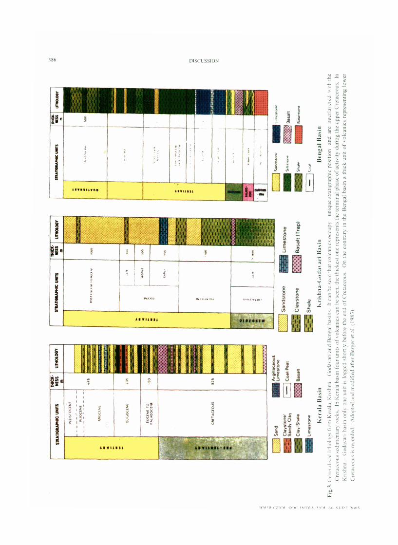
Fig
.3. (
ien
cl~
.il~
~cJ
l~
tlii
rlog
s from
Ker
ala,
Kri
shna
- G
odav
ari a
nd
Ben
gal
basi
ns.
It c
an b
e sc
en t
hat
volc
anic
s oc
cupy
un
ique
str
atig
raph
ic p
osit
ion
and
are
i~~
~c
rla
~c
~c
d
ill]
the
Cre
tace
ous
sedi
men
tary
roc
ks.
In K
eral
a ba
sin
four
uni
ts o
f vo
lcan
ics
can
be s
een.
the
thi
ckes
t on
e re
pres
ents
the
ter
min
al p
hase
of
acti
vity
dur
ing
the
uppe
r C
reta
ceou
s.
In
Kri
shna
- G
oda\
.ari
bas
in o
nly
one
unit
is
logg
ed s
hort
ly b
efor
e th
e en
d of
Cre
tace
ous.
O
n th
e co
ntra
ry i
n th
e B
enga
l ba
sin
a th
ick
unit
of
volc
anic
s re
pres
enti
ng l
ower
C
reta
ceou
s is
rec
orde
d.
Ado
pted
and
mod
ifie
d af
ter
Ber
ger
et a
l. (
1 983
).

DISCUSSION 387
3. Whether these zones and centres continued outpouring of lava from the beginning to the end of volcanism and did lavas travel to long distances such as Rajahrnundry, Mandla and Rajmahal areas?
Two such zones whlch seem t o have continued outpouring of lava from almost beg~nning to the end of volcanlsrn coinc~de wlth the major geologrcal structures and they are Narrnadd - Taptl tectonic zone and Cambay structure Along these structures a great varrety of volcanic rocks, explosxve volcanism, emplacement of plugs, volcanic cones, and domes are recorded
There are no field evidences to suggest that lavas traveled to very long distances such as Rajahmundry, Mandla and Rajmahal regions Incorporation of bore hole data from Bengal basin, off-shore Mahanadr, on-shore and off-shore Knshna-Godavan basrn, Mannar bas~n, Kerala-Lakshadweep basin and Slndh basin has brought out consanguineous quartz normatrve thole~ites in far off regions These reglons of outpouring of lavas are located In the intersectional areas of major geological structures (Misra, 2004) Drilling data reveals that the Deccan and all other associated volcan~cs occupy unique stratlgraphlc positlon confined w thin the Cretaceous p e r ~ o d (Fig 3) Slnce these volcanics are Interlayered wrth fosstlrferous horizons thelr ages could be established unambiguously (M~sra , 2004) Further, the assocration suggests that there were several pulses of volcan~sm from the beginnrng to the end of Cretaceous The Important fact thus emerges out IS that, the volcanlsrn continued for fairly long duratton of nearly 80 rnilllon years
4. If the volcanism is of multicentral nature is it worthwhile to work on unified lava stratigraphy for the entire Deccan volcanic province ?
It was because of the nonrecognition of effusive centres and zones within the Deccan volcanics, ~t was assumed earlier that eruption of volcanics has taken place from a slngle volcanoe which was b e l ~ e v e d to have existed somewhere in the west and now submerged rn the Arabtan sea A chemxcaI approach for establishing a unified stratlgraphy was adopted by several groups This approach has very serious drawbacks which are absence of distrngulshxng chemical signatures in the general quartz normative tholeiites whlch could help to map them in field Reproductxon of the reported ratios of trace elements even after very elaborate and sophistrcated analysis has also not been ach~eved Furthermore, most of the work 1s done only along a few traverses and also in the mlddle and supper sequences only Lower felslc sequence was not taken ~ n t o consideration because of older radiometric ages Attempts have been made to explain the outcrops of associated volcanics drfferently by lnvoklng a number of mantle plumes Apart from these, all the attempts to establish unified stratigraphy dld not take ~ n t o account Innumerable regional faults along whlch vertical tectonics IS quite pronounced Depositron of t h ~ c k sediments (<400m) along many structures during Quaternary alone indicates large elevation differences and any stratlgraphy established across them will certainly be erroneous
References
AVINASH CHANDRA, (2004) Emerging trend in 011 and gas exploration In Indla - A bright future ahead, Jour Geophys , vXXV, nos 2&3, pp 3 11
BERGER, P, CERNY, P, HOOK J C , JAFFEX, KABIR, C S , KUMAR, R , MINNE, J C , PINNINGTOU, D J , SERRA, 0, SHUKLA, S N , SIBBIT and VISVANATH, $ N (1983), Petroleum Geology of Indla In Schlurnberger, Well Evaluation Conference, pp 1-36
B~SWAS S K (1987) Regional tectonlc framework, structure and evolutron of the western marglnal basins of Indla Tectonophyslcs, v 135, pp 307-327
GUHA, S K and BASU, PC (1993) Catalogue of Earthquake (>M 3 0) kn Pen~nsular lndla AERB Techntcal Document No TD/CSE- I , pp 1-70
KARANTH, R V and SANT, D A (1995) Lineaments and Dyke Swarms of Lower Narmada Valley and Southern Saurashtra, Western Indla Mern Geol Soc India, No 33, pp 425-434
MISHRA, D C , BIENDRA SINGH, GUPTA, S B , PRARHAKAR RAO, M R K , SLNGH, A P, CHANDRASEKHAR, D V , HODLUR, G K ,
RAO, M B S V , TIWARI, V M , LAXMAN, G , VENKATA RAN, D CH , VIIAY KUMAR, V , RAJESH, R S , BABU RAO, V and CHETTY, T R K (2001) Major Lineaments and Gravity - Magnetlc trends in Saurashtra, Ind~a Cum Scl , v 80, pp 1059 1067
MISRA, K S (2004) Deccan and associated volcan~cs and then relat~onsh~p with the development of Hydrocarbon pools around pentnsular lndta Souvenir volume 20th Annual Convention and Semrnar on Exploration Geophysics 2-5 November, 2004 Guwahatl
MISRA, K S (2002) Artenal System of Lava Tubes and Channels w~thin Deccan Volcan~cs of Western Tndla Jour Geol Soc India, v 59, pp 11 5 124
MISRA, K S (2001a) L~neament Fabric and ~ t s relatron to the Erupt~on of Deccan Volcanlcs and Seism~clty of West- Central Indla Geol Surv Indla Pub1 No 64,2001, pp 209- 22 1
MISRA, K S (2001b) The "Panvel Flexure" Part of a Large
JOUR GEOL SOC INDIA, VOL 66 SEPT 2005
388 DISCUSSION
Structure In Western Ind~a Mern Geol Soc Ind~a, No 47, pp 225-232
MISRA, K S (1999) Deccan volcanlcs In Saurashtra and Kutch, Gujarat, Ind~a Mem Geol Soc Ind~a No 43, pp 325- 33 5
MISRA, K S (1980) Tectonlc Setting of Deccan Volcanlcs In Southern Saurashtra and Northern Gujarat Memoir Geol Soc Indla 3 pp 8 1-86
MISRA, K S , BHUTANI R and SONP, R (2004) Seismogeology of the Kutch and Adjotning Reglon, wlth speclal reference to 26th January 2001 Earthquake In v~cinlty of Bachau, Gujarat Jour Geol Soc Indla, v 64, pp 153-164
MISRA, K S , SABLE, A B and BHUTANI, R (2001~) Lava Channel/ Tube network In western Maharashtra Study of thelr Morphology, Formation and Transportation of Deccan Lava Geol Surv India Spl Pub1 No 64, pp 503-5 10
RADHAKRISHNA, B P (2004) Extra-Terrestrial impacts In the geological past Some reflect~ons Jour Geol Soc India, v 64, pp 127-132
RAVI SHANKER and PANDE, P (2001) Geoseismological Stud~es of Kutch (Bhuj) Earthquake of 26 January 2001 Jour Geol Soc Indla, v 58, pp 203-208
SREBDHAR MURTHY, Y (1 999) Images of the gravlty field of lndla and their sallent features Jour Geol Soc Indla, v 54, pp 22 1 - 225
SREEDHAR MURTHY, Y and RAVAL, U (2000) Bouguer gravity Image of India and the nelghbourlng ESCAP reglon a study of tectonrcs and natural resources, Jour Geophys , v XXI, n 2, pp 59-70
SREEDHAR MURTHY, Y (2002) On the correlation of se~sm~city with geophysical l~neaments over the Indlan subcontment, Curr SCI , v 83, no 6, pp 760-766
ANNOUNCEMENTS
TRAINING COURSE IN HYDROGEOCHEMISTRY
A short term tralnlng course In "Mathematical Models In Hydrogeochernlstry Assessment of Groundwater Quallty and Management" 1s scheduled durrng 19th September to 5th October, 2005 at the School of Environmental Sc~ences, Jawaharlal Nehru Universlty, New Delhr For further detarls, please contact AL Ramanathan, School of Environmental Sc~ences, Jawaharlal Nehru Universlty, New Delhl - 110 067 Phone: 9 1- 1 1-26 194938, Fax: 91 -1 1-26106501, Email: hydromodel~nu@yahoo co In
25'" INTERNATIONAL CARTOGRAPHIC CONGRESS OF INDIAN CARTOGRAPHIC ASSOCIATION (INCA)
The above Congress with the focal theme of 'Bndglng the Dtgltal Dlvlde and Taklng Cartography to Grass root Level' IS being organised by the Department of Applied Geology, Dr H S Gour Unlversity, Sagar, M P, durlng 28 Nov - 1 Dec , 2005 For further detalls, please contact Dr R K Trrvedi, Secretary, 25th INCA, Department of Applled Geology, Dr H S Gour Unlversity, Sagar - 470 03, M P Phone/Fax: +91 7582-265300 (O), Mobile: 0098268 30045, Email: 1nca25_sagar@red1ffm1al com, 1nca25_sagar@ yahoomall corn Registration form and other lnforrnat~on can be downloaded from www sagarunrversity nlc In, www incalndia corn
SEDIMENTARY BASINS OF THE HIMALAYAS: CHALLENGES FOR THE FUTURE AND XXII CONVENTION OF INDIAN ASSOCIATION OF SEDIMENTOLOGISTS
The above convention is scheduled to take place at Dehra Dun during 21 -23, December 2005 For further details, please contact Dr Surnit Ghosh, Wadia Institute of Himalayan Geology, 33 Gen Mahadeo Slngh Road, Dehra Dun - 248 001 (UA) Phone: 01 35-2624805 Ext 55 1 (O), 0135-2625773 (R), 941238 1 15 1 (M), Email: skghosh@wrhg res In or skgesh@redlffmail corn
NATIONAL SEMINAR ON HYDROLOGY WITH SPECIAL REFERENCE TO URBAN GROUNDWATER POLLUTION
The above semtnar 1s being organlsed to colnc~de with the XXIV Annual Convent~on of the Assoc~atlon of Hydrologists of Indi durlng 27-28 December, 2005 at the Department of Studles In Geology, Kamatak Unlverslty, Dharwad For further detalls, please contact Prof S C Puranik, Department of Studtes In Geology, Karnatak University, Dharwad - 580 003 Phone: 0836-2215288 (O), 2743728 (R), Fax: 0836-2747884 / 2771275, Email: scpuranik@yahoo corn
JOUR GEOL SOC INDIA, VOL 66, SEPT 2005


![Design Portfolio [Taloza, K.S.]](https://img.pdfslide.us/doc/110x75/55c7e485bb61ebc56e8b4728/design-portfolio-taloza-ks.jpg)