Embed Size (px)
Citation preview

Reference Guide
of
Airport Clear Zones
in
Minnesota
May 2008
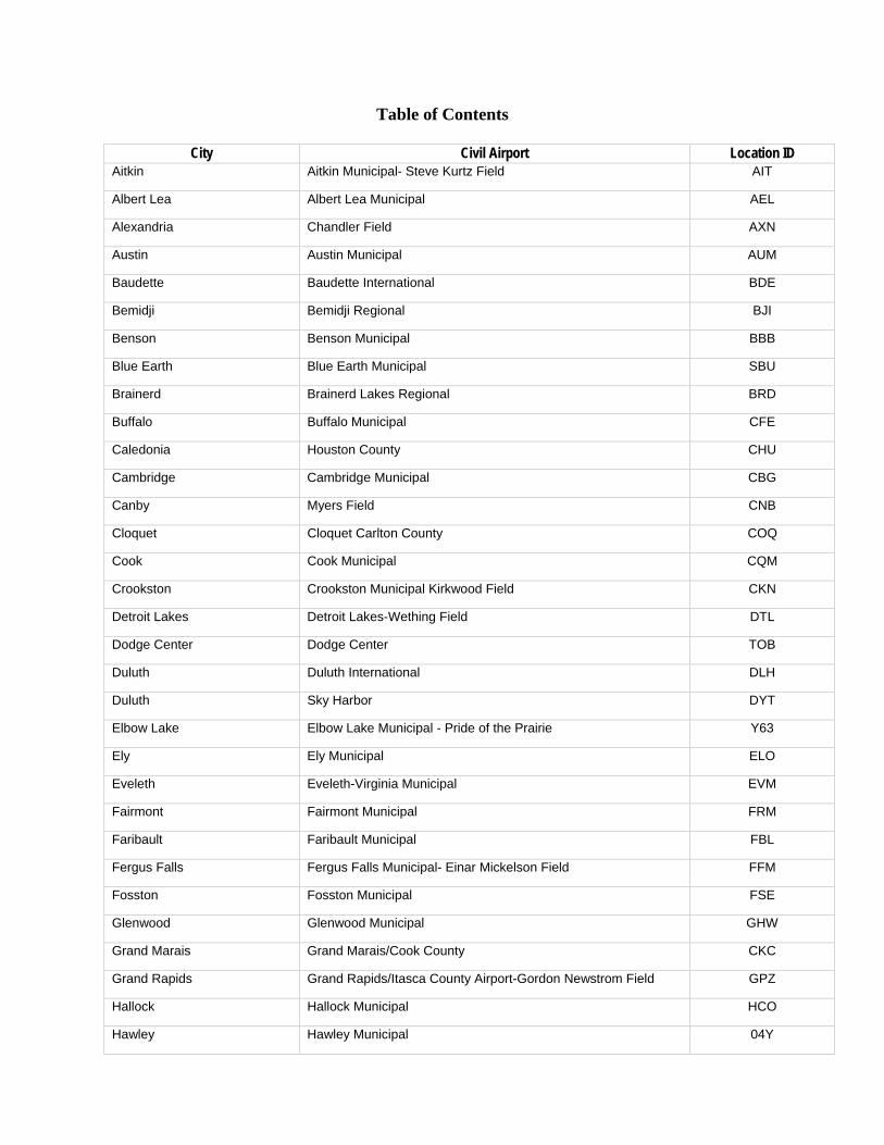
Table of Contents
City Civil Airport Location ID Aitkin Aitkin Municipal- Steve Kurtz Field AIT
Albert Lea Albert Lea Municipal AEL
Alexandria Chandler Field AXN
Austin Austin Municipal AUM
Baudette Baudette International BDE
Bemidji Bemidji Regional BJI
Benson Benson Municipal BBB
Blue Earth Blue Earth Municipal SBU
Brainerd Brainerd Lakes Regional BRD
Buffalo Buffalo Municipal CFE
Caledonia Houston County CHU
Cambridge Cambridge Municipal CBG
Canby Myers Field CNB
Cloquet Cloquet Carlton County COQ
Cook Cook Municipal CQM
Crookston Crookston Municipal Kirkwood Field CKN
Detroit Lakes Detroit Lakes-Wething Field DTL
Dodge Center Dodge Center TOB
Duluth Duluth International DLH
Duluth Sky Harbor DYT
Elbow Lake Elbow Lake Municipal - Pride of the Prairie Y63
Ely Ely Municipal ELO
Eveleth Eveleth-Virginia Municipal EVM
Fairmont Fairmont Municipal FRM
Faribault Faribault Municipal FBL
Fergus Falls Fergus Falls Municipal- Einar Mickelson Field FFM
Fosston Fosston Municipal FSE
Glenwood Glenwood Municipal GHW
Grand Marais Grand Marais/Cook County CKC
Grand Rapids Grand Rapids/Itasca County Airport-Gordon Newstrom Field GPZ
Hallock Hallock Municipal HCO
Hawley Hawley Municipal 04Y
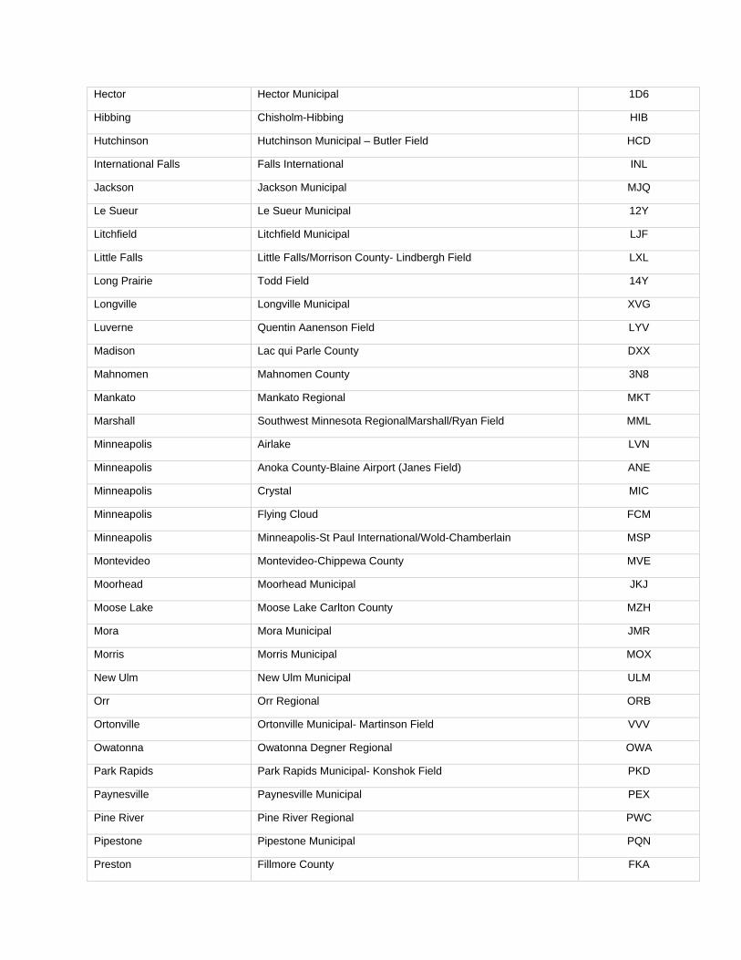
Hector Hector Municipal 1D6
Hibbing Chisholm-Hibbing HIB
Hutchinson Hutchinson Municipal – Butler Field HCD
International Falls Falls International INL
Jackson Jackson Municipal MJQ
Le Sueur Le Sueur Municipal 12Y
Litchfield Litchfield Municipal LJF
Little Falls Little Falls/Morrison County- Lindbergh Field LXL
Long Prairie Todd Field 14Y
Longville Longville Municipal XVG
Luverne Quentin Aanenson Field LYV
Madison Lac qui Parle County DXX
Mahnomen Mahnomen County 3N8
Mankato Mankato Regional MKT
Marshall Southwest Minnesota RegionalMarshall/Ryan Field MML
Minneapolis Airlake LVN
Minneapolis Anoka County-Blaine Airport (Janes Field) ANE
Minneapolis Crystal MIC
Minneapolis Flying Cloud FCM
Minneapolis Minneapolis-St Paul International/Wold-Chamberlain MSP
Montevideo Montevideo-Chippewa County MVE
Moorhead Moorhead Municipal JKJ
Moose Lake Moose Lake Carlton County MZH
Mora Mora Municipal JMR
Morris Morris Municipal MOX
New Ulm New Ulm Municipal ULM
Orr Orr Regional ORB
Ortonville Ortonville Municipal- Martinson Field VVV
Owatonna Owatonna Degner Regional OWA
Park Rapids Park Rapids Municipal- Konshok Field PKD
Paynesville Paynesville Municipal PEX
Pine River Pine River Regional PWC
Pipestone Pipestone Municipal PQN
Preston Fillmore County FKA
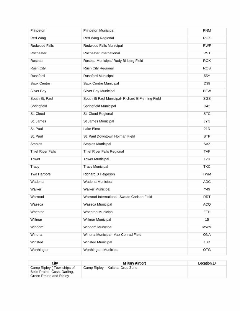
Princeton Princeton Municipal PNM
Red Wing Red Wing Regional RGK
Redwood Falls Redwood Falls Municipal RWF
Rochester Rochester International RST
Roseau Roseau Municipal/ Rudy Billberg Field ROX
Rush City Rush City Regional ROS
Rushford Rushford Municipal 55Y
Sauk Centre Sauk Centre Municipal D39
Silver Bay Silver Bay Municipal BFW
South St. Paul South St Paul Municipal- Richard E Fleming Field SGS
Springfield Springfield Municipal D42
St. Cloud St. Cloud Regional STC
St. James St James Municipal JYG
St. Paul Lake Elmo 21D
St. Paul St. Paul Downtown Holman Field STP
Staples Staples Municipal SAZ
Thief River Falls Thief River Falls Regional TVF
Tower Tower Municipal 12D
Tracy Tracy Municipal TKC
Two Harbors Richard B Helgeson TWM
Wadena Wadena Municipal ADC
Walker Walker Municipal Y49
Warroad Warroad International- Swede Carlson Field RRT
Waseca Waseca Municipal ACQ
Wheaton Wheaton Municipal ETH
Willmar Willmar Municipal 15
Windom Windom Municipal MWM
Winona Winona Municipal- Max Conrad Field ONA
Winsted Winsted Municipal 10D
Worthington Worthington Municipal OTG
City Military Airport Location ID Camp Ripley ( Townships of Belle Prairie, Cush, Darling, Green Prairie and Ripley
Camp Ripley – Kalahar Drop Zone

Spencer Township
Aitkin Township
Aitkin City
County Rd 54
Stat
e Hwy
210
State Hwy 47
Cou
nty
Hw
y 1
1st St NW
6th
Ave
SE
County
Rd 5
5
County Hwy 22
3rd St NW
5th St NW
4th St SE
Airpark Ln
2nd St NE
Min
neso
ta A
ve S C
ount
y H
wy
12C
ount
y R
d 83
US
Hw
y 16
9M
inne
sota
Ave
NW
4th Ave NE
Maryhill La
8th
Ave
NW
Grand View
2nd
Ave
SW
Cou
nty
Hw
y 12
Aitkin Municipal - Steve Kurtz Field (AIT)
Airport Runway Clear Zone
Legend3,000 Feet around Civilian Airport (Airport Clear Zone)
Civilian Aiport
0 2,500 5,0001,250 FeetSource: Minnesota Department of Transportation (Mn/DOT)Created by: Minnesota Housing
Bancroft Township
Albert Lea City
Albert Lea Township
Manchester Township
Pickerel Lake Township
I-90
I-35
E Main St
Brid
ge A
ve
State Hwy 13C
ount
y H
wy
45
Cou
nty
Hw
y 20
County Hwy 14
Plaza St
Cou
nty
Hw
y 22
Hammer Rd
W Clark St
County Rd 99
Gar
field
Ave
Muskie Ave
County Rd 101
Lakeview Blvd
Sykes St
W Richway Dr
Main St W
County Rd 92
County Rd 88
Stevens St
W Fountain St
Blu
egra
ss R
d
Sheridan St
County Rd 91Water St
E Front St
W Main St
Hershey St
Gar
den
Rd
Sunset StHawthorne St
Olse
n Dr
Bla
ke A
ve
Itasca Rd
Consul St
SE Marshall St
Abbott St
Lake
Cha
peaq
u D
r
Landfill Rd
Martin Rd
Cedar Ave
E Richway Dr
W Edgewater Dr
Gre
enw
ood
Dr
E Clark St
Johnson St
Pilot St
Wedgewood Rd
Sorenson R
d
Court St
Crestview
Rd
Fairlane Ter
Riverland Dr
Elmira St
Bay O
aks Dr
Airport RdElm St
Allan Dr
Glenn Rd
Hoe
ger L
a
Quisley St
Louis St
Campus La
Col
umbu
s Av
e
Grace StAlbert Lea St
Becker Dr
Knoll Dr S 5
th A
ve
Eberhart St
State St
N 7
th A
ve
I-90Plaza St
Sunset St
I-35
I-35
I-35
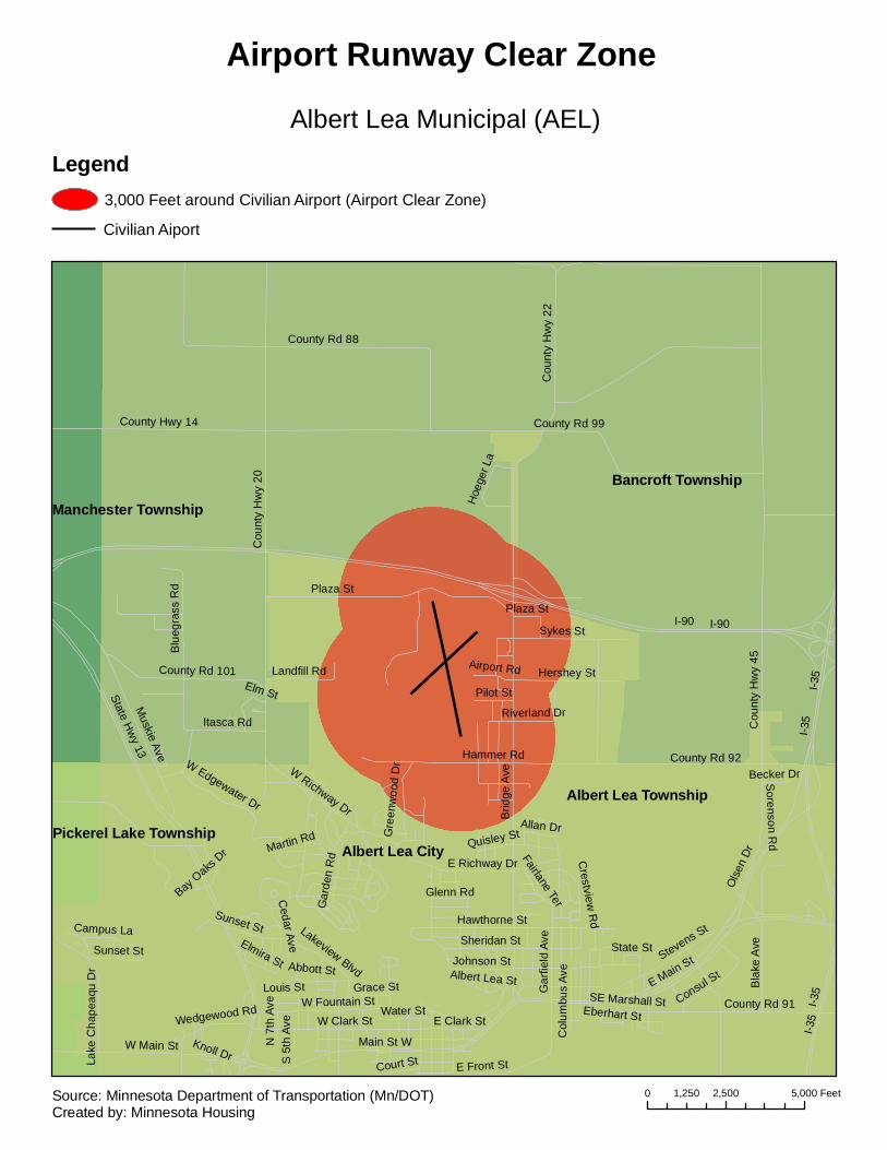
Albert Lea Municipal (AEL)
Airport Runway Clear Zone
Legend3,000 Feet around Civilian Airport (Airport Clear Zone)
Civilian Aiport
0 2,500 5,0001,250 FeetSource: Minnesota Department of Transportation (Mn/DOT)Created by: Minnesota Housing
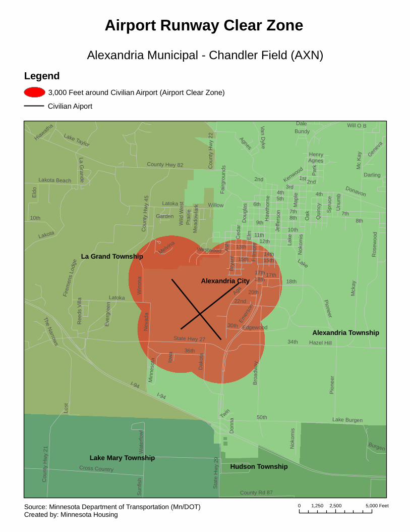
Alexandria City
La Grand Township
Lake Mary Township
Alexandria Township
Hudson Township
I-94
6th
3rd
50th
Mck
ay
11th
7th8th
5th
9th
12th
34th
Elm
Aga
4th
Latoka
State Hwy 27
Fillm
ore
Nok
omis
36th
Jeffe
rson
Ash
County Hwy 82
Ros
ewoo
d
Win
ona
Cou
nty
Hw
y 45
Agnes
LakotaC
edar
Cross Country
Sta
te H
wy
29
Bro
adw
ay14th
Nev
ada
Mc
Kay
Cou
nty
Hw
y 21
Pio
neer
18th
13th
Oak
Eld
o
Bry
ant
Dak
ota
Dou
glas
10th
Lakota Beach
Fire
men
s Lo
dge
Kenwood
22nd
Qui
ncy
County Rd 87
15th Lake
Edgewood
Genev
a
Lake Burgen
Willow
17th
Lost
30th
Hazel Hill
Spr
uce
Van Dyke
Westwood
Cou
nty
Hw
y 22
Ever
gree
n
Emer
son
Sun
fish
La Grande
Min
neso
ta
Darling
Fairg
roun
ds
Lake Taylor
Pra
irie
Burgen
Henry
Par
k
1st
Wat
erfo
wl
Twin
2nd
Unu
mb
Melvina
Map
le
Garden
Dale
The Narrow
s
Will O B
Mea
dow
lark
Iow
a
Don
na
Donavon
20th
Bundy
Wild
Wes
t
Ree
ds V
illa
Hiawatha
Haw
thor
ne
Nok
omis
18th
15th
17th
2nd
8th
7th
I-94
Latoka
10th
Agnes
Pioneer
Lake
4th
Alexandria Municipal - Chandler Field (AXN)
Airport Runway Clear Zone
Legend3,000 Feet around Civilian Airport (Airport Clear Zone)
Civilian Aiport
0 2,500 5,0001,250 FeetSource: Minnesota Department of Transportation (Mn/DOT)Created by: Minnesota Housing

Austin City
Windom Township
Austin Township
Red Rock TownshipLansing TownshipMapleview City
I-90
205th
4th
575t
h
28th
220th
215th
29th
570t
h
580t
h
560t
h
235th
US Hwy 2
18
Oakland
19th
555t
h
1st
11th
3rd
6th
2nd
190th
195th
14th
5th
8th
20th
12th
7th
22nd
540t
h
9th
21st
16th
Mai
n
17th
County Hwy 45
Hormel
Clin
ton
15th
18th
13th
10th
6th
3rd
12th
2nd
7th
5th
16th
7th
14th
3rd
1st
5th
9th
Mai
n
7th
7th10th
Oakland
County H
wy 45
3rd
14th
14th
3rd
9th
16th
2nd
12th
11th
7th
12th
6th
4th
21st
10th
10th
1st
10th
5th7th
3rd
2nd
8th
17th
6th
16th
5th
1st
7th
7th
11th
3rd
7th
4th
15th
1st
13th
18th
I-90
8th
11th
3rd
5th
21st
5th
15th
6th
10th
8th
7th
13th
18th
14th 11th
195th
4th
11th
4th
8th
11th
13th
Austin Municipal (AUM)
Airport Runway Clear Zone
Legend3,000 Feet around Civilian Airport (Airport Clear Zone)
Civilian Aiport
0 2,500 5,0001,250 FeetSource: Minnesota Department of Transportation (Mn/DOT)Created by: Minnesota Housing

Spooner Unorganized
Baudette City
Baudette Unorganized
Gudrid Unorganized
County Hwy 35
Sta
te H
wy
172
Main St E
State Hwy 11
Cou
nty
Hw
y 39
Cou
nty
Hw
y 3
Cou
nty
Rd
164
County Rd 88
Sta
te H
wy
72
Cou
nty
Hw
y 1
9th
Ave
SE
Main St W
2nd St NW
1st St SE
County Rd 78
Cou
nty
Rd
165
International Dr
4th St NE
3rd
Ave
SE
Airp
ort R
d NW
Asp
lund
Dr S
E
Main St
5th St SW
3rd St SW Par
k D
r NE
Lind
en A
ve N
E
Baudette International (BDE)
Airport Runway Clear Zone
Legend3,000 Feet around Civilian Airport (Airport Clear Zone)
Civilian Aiport
0 2,500 5,0001,250 FeetSource: Minnesota Department of Transportation (Mn/DOT)Created by: Minnesota Housing

Eckles TownshipNorthern Township
Bemidji CityGrant Valley Township
Wilton City
Bemidji Township
Balsam
Irvin
e
15th
US Hwy 2
Eck
les
Fern
Car
dina
l
30th
Anne
23rd
Par
k
Ada
ms
US H
wy 7
1
Gillett
Wildrose
9th
Han
nah
Nor
ton
12th11th
8th
10th
21st
14th
29th
20th
26th
Ced
ar
Del
ton
7th
Lakewood
Pine
Mayflower
Net
Melby
24th
Pin
e R
idge 34th
28th
18th19th
Mid
dle
Sch
ool
Min
nkot
a
Rid
gew
ay
Laur
elCricket
County H
wy 11
Pow
er
Ash
Bar
dwel
l
16th
Rose
Hiway
Mob
erg
Ric
e
Spike
Johnson
Gre
enle
af
Am
eric
a
Com
fort
Lilac
US Hwy 2
Irvin
e
Del
ton
US
Hw
y 71
Car
dina
l
24th
Bemidji Regional (BJI)
Airport Runway Clear Zone
Legend3,000 Feet around Civilian Airport (Airport Clear Zone)
Civilian Aiport
0 2,500 5,0001,250 FeetSource: Minnesota Department of Transportation (Mn/DOT)Created by: Minnesota Housing

Clontarf Township
Six Mile Grove Township
Benson Township
Benson City
Torning Township
Clontarf City
US Hwy 12
State Hwy 9
County Hwy 20
AtlanticS
tate
Hw
y 29
Chu
rch
UtahPacific
Minnesota
18th
21st
Hall
14th16th
Cou
nty
Hw
y 3
15th
Cou
nty
Hw
y 15
Wisconsin
County Rd 75
13th
Denfield
Wood
19th
17th
County Rd 75
19th
Benson Municipal (BBB)
Airport Runway Clear Zone
Legend3,000 Feet around Civilian Airport (Airport Clear Zone)
Civilian Aiport
0 2,500 5,0001,250 FeetSource: Minnesota Department of Transportation (Mn/DOT)Created by: Minnesota Housing
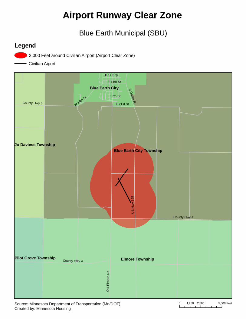
Blue Earth City Township
Elmore Township
Blue Earth City
Jo Daviess Township
Pilot Grove Township
US
Hw
y 16
9
County Hwy 4
County Hwy 6 W 14th St
S Grove St
E 14th St
Old
Elm
ore
Rd
E 21st St
E 12th St
17th St
County Hwy 4
Blue Earth Municipal (SBU)
Airport Runway Clear Zone
Legend3,000 Feet around Civilian Airport (Airport Clear Zone)
Civilian Aiport
0 2,500 5,0001,250 FeetSource: Minnesota Department of Transportation (Mn/DOT)Created by: Minnesota Housing

Oak Lawn Township
West Crow Wing Unorganized
Brainerd City
State H
wy 210
Sta
te H
wy
25
J St
Cou
nty
Hw
y 25
H StG St
F St
Mill
s A
ve
I St
E St
O St
County R
d 142
Coun
ty H
wy 2
0
N St
L St
White Pine Dr NE
Exective Acres Rd
C St
M St
K St
Q St
County Rd 119
County Hwy 49
Ironwood Dr NE
Lakeview La
Easy St NE
Riverview Dr
Woo
leat R
d
Wonderl
and P
ark Rd
I StI St
K St
Brainerd Lakes Regional (BRD)
Airport Runway Clear Zone
Legend3,000 Feet around Civilian Airport (Airport Clear Zone)
Civilian Aiport
0 2,500 5,0001,250 FeetSource: Minnesota Department of Transportation (Mn/DOT)Created by: Minnesota Housing

Buffalo CityBuffalo Township
Rockford Township
Chatham Township
Marysville Township
Maple Lake Township
8th
Eak
en
10th
Dag
ue
State Hwy 55
Ahe
rn
20th
1st
3rd
Cal
der
Car
ling
Dalton
Eck
ert
Cou
nty
Rd
134
Cen
tral
17th
2nd
Lake
16th
Pulaski
County Hwy 35
18th
Division
Mon
trose
7th
Ferd
inan
5th
6th
21st
30th
12th
Par
9th
Dal
e
County Hwy 12
Aetina
22nd
Oak
Buffa
lo
14th
13th
Catlin
4thPi
ntai
l
25th
Park
Centenial
Juni
per
Blue
Bill
Com
mer
cial
Ebe
rsol
e
Viki
ng
15th
11th
Sigrid
SchubertBrighton
Creekside
Rob
ertsGriffingWoo
ds
Car
terb
ury
Atla
s
Kensington
Maple
Lilac
Oak
Lake
10th
3rd
2nd
5th
Lake
2nd
3rd
5th
8th 10th
Dag
ue
7th
4th
10th
10th
4th
6th
6th
14th
6th
2nd
3rd
9th
3rd
4th
8th
3rd
7th
18th
10th
4th
16th
12th
2nd
8th
2nd
Division
12th
4th
Buffalo Municipal (CFE)
Airport Runway Clear Zone
Legend3,000 Feet around Civilian Airport (Airport Clear Zone)
Civilian Aiport
0 2,500 5,0001,250 FeetSource: Minnesota Department of Transportation (Mn/DOT)Created by: Minnesota Housing

Caledonia TownshipMayville Township
Wilmington Township Winnebago Township
Caledonia City
Cou
nty
Hw
y 5
State Hwy 44
Sta
te H
wy
76
County Hwy 12
Cou
nty
Hw
y 28
County Rd 249
County Hwy 14
E Adams St
S W
inne
bago
St
Ric
hard
s S
t
Old
44
Rd
W South St
Houston County (CHU)
Airport Runway Clear Zone
Legend3,000 Feet around Civilian Airport (Airport Clear Zone)
Civilian Aiport
0 2,500 5,0001,250 FeetSource: Minnesota Department of Transportation (Mn/DOT)Created by: Minnesota Housing
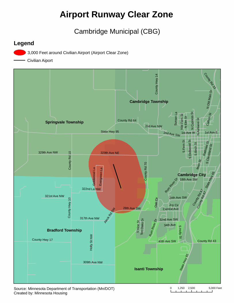
Bradford Township
Springvale Township
Cambridge City
Cambridge Township
Isanti Township
Mai
n St
Cou
nty
Rd
70
State Hwy 95
Stat
e Hw
y 65
Cou
nty
Hw
y 10
329th Ave NE
Cou
nty
Rd
67
1st Ave W
Cou
nty
Hw
y 14
County Rd 64
Cou
nty
Rd
10
County Hwy 17
Hol
ly S
t NW
2nd Ave SW
S B
irch
St
329th Ave NW
309th Ave NW
S F
ern
St
S D
ellw
ood
St
317th Ave NW
N O
ld M
ain
St
Rai
lroad
St
322nd La NW
40th Ave SW
S C
leve
land
St
S H
olly St
321st Ave NW
County Rd 43
Central Ave
Gol
denr
od L
a
N C
ypre
ss S
t
Eve
rgre
en L
a
1st Ave E
County Rd 33
Rum
Riv
er D
r 32nd Ave SW
NW
Fer
n S
t
28th Ave SW
18th Ave SW
24th Ave SW
2nd Ave NW
Alec
k Rd
SW
N A
shla
nd S
t
Sun
set L
a
S V
ine
St
Cal
hon
St
Joy Cir
Ten
Oak
s D
r
Oak
Cir
34th Ave
N E
lm S
t
Rum R
iver D
r
Coun
ty R
d 67
Stat
e H
wy
65
Cambridge Municipal (CBG)
Airport Runway Clear Zone
Legend3,000 Feet around Civilian Airport (Airport Clear Zone)
Civilian Aiport
0 2,500 5,0001,250 FeetSource: Minnesota Department of Transportation (Mn/DOT)Created by: Minnesota Housing
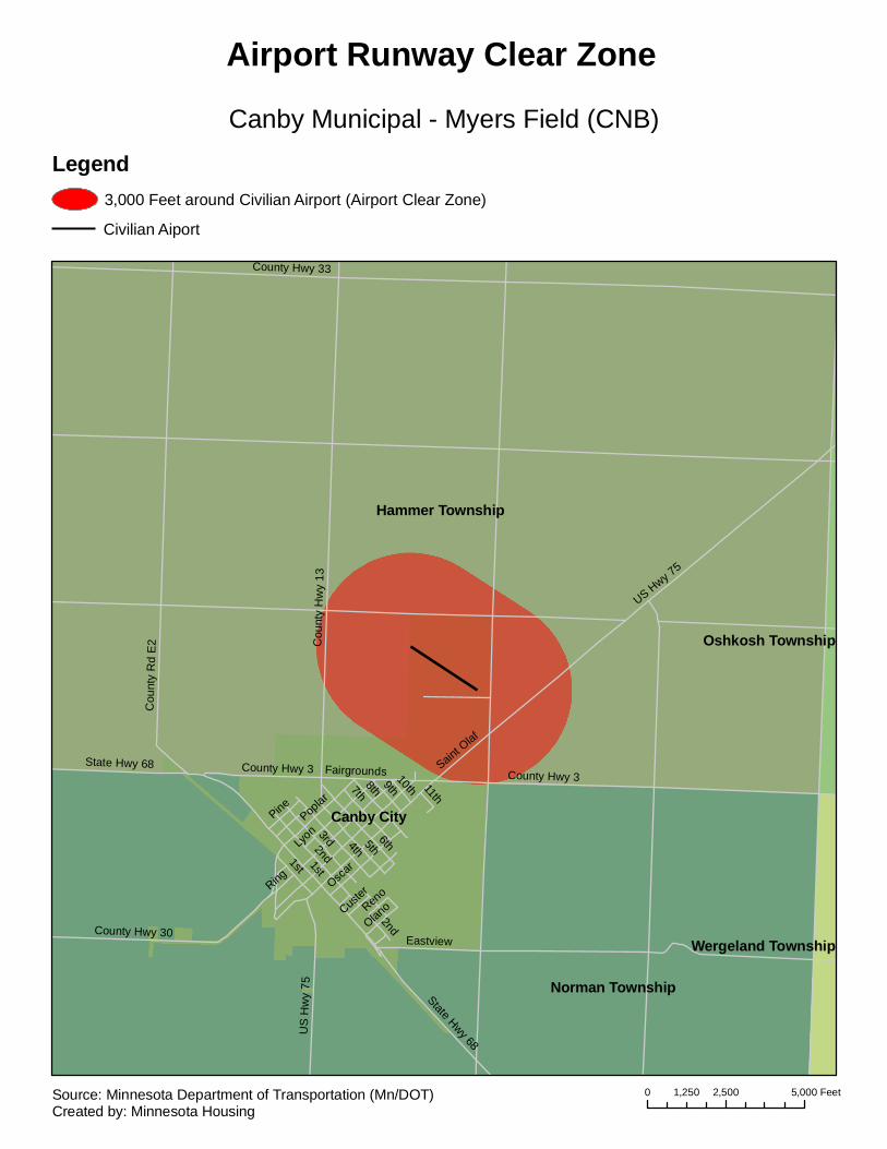
Hammer Township
Norman Township
Canby City
Wergeland Township
Oshkosh Township
1st
County Hwy 33
US Hwy 75
Cou
nty
Hw
y 13
4th
6th2nd3rd
County Hwy 3Saint O
laf
5th8th7th
LyonPop
lar
Oscar
County Hwy 30
Cou
nty
Rd
E2
9th
State Hwy 68
Eastview
Fairgrounds
Pine
Ring
Olano
10th
Reno
11th
Custer
1st
County Hwy 3
2nd
US
Hw
y 75
State Hwy 68
Canby Municipal - Myers Field (CNB)
Airport Runway Clear Zone
Legend3,000 Feet around Civilian Airport (Airport Clear Zone)
Civilian Aiport
0 2,500 5,0001,250 FeetSource: Minnesota Department of Transportation (Mn/DOT)Created by: Minnesota Housing
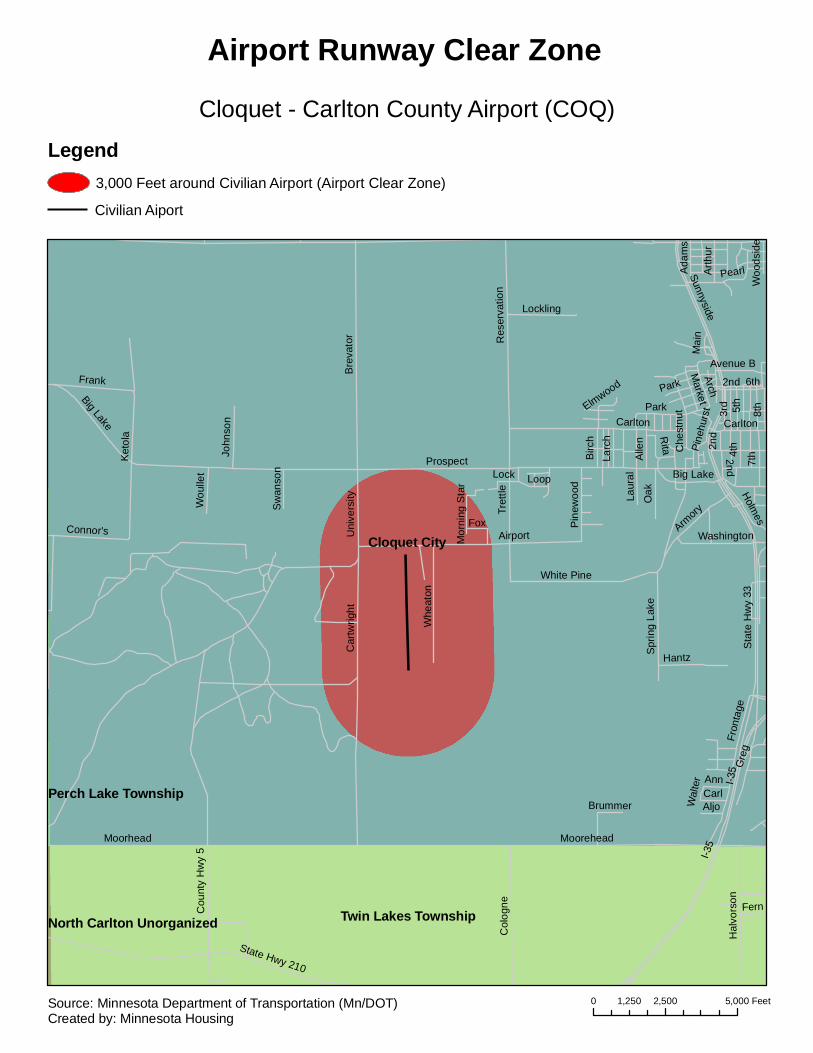
Cloquet City
Twin Lakes TownshipNorth Carlton Unorganized
Perch Lake Township
I-35
Prospect
Moorehead
Airport
Cou
nty
Hw
y 5
Ket
ola
Sta
te H
wy
33
Car
twrig
htB
reva
tor
Carlton
State Hwy 210
Res
erva
tion
Spr
ing
Lake
Fron
tage
Col
ogne
Moorhead
Sunnyside
Frank
Hal
vors
on
White Pine
3rd
8th
4th
7th
Whe
aton
Big Lake
Armory
Oak
Gre
g
Tret
tle
Hantz
2nd
Alle
n
5th
Arch
Connor's Uni
vers
ity Holmes
Lockling
Loop
Che
stnu
t
Birc
h
Washington
Pin
ewoo
d
6th
John
son
Arth
ur
Larc
h
Fox
Market
AnnCarl
Wou
llet
Ada
ms
Aljo
Laur
al
Pearl
Rita
Fern
Avenue B
Mai
n
Lock
Brummer
Sw
anso
n
Elmwood
Pine
hurs
t
Mor
ning
Sta
r
Park
Wal
ter
Woo
dsid
e
Park
I-35
Big Lake
2nd
Carlton
2nd
Cloquet - Carlton County Airport (COQ)
Airport Runway Clear Zone
Legend3,000 Feet around Civilian Airport (Airport Clear Zone)
Civilian Aiport
0 2,500 5,0001,250 FeetSource: Minnesota Department of Transportation (Mn/DOT)Created by: Minnesota Housing

Owens TownshipField Township
Angora TownshipAlango Township
Cook City
US
Hw
y 53
Ral
ph R
d
Leander Rd
Wein Rd
Sam
uels
on R
d
Hee
l Rd
Sav
age
Rd
Armstrong Rd
Riv
er S
t
Johnson Rd
E Leander Rd
Buboltz Rd
E Gustafson Rd
E Lind Rd
3rd Ave
3rd Ave SE
Derusha Rd
Ran
ge S
t
Vermilion Blvd
Owens Ave
Sav
age
Rd
Sam
uels
on R
d
Cook Municipal (CQM)
Airport Runway Clear Zone
Legend3,000 Feet around Civilian Airport (Airport Clear Zone)
Civilian Aiport
0 2,500 5,0001,250 FeetSource: Minnesota Department of Transportation (Mn/DOT)Created by: Minnesota Housing
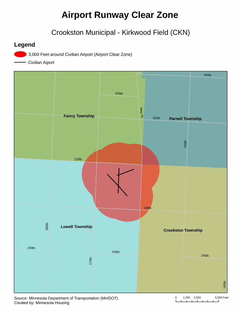
Lowell Township
Fanny Township
Crookston Township
Parnell Township
150t
h
170t
h
180t
h
110th
130th
Hw
y 75
120th
100th
140th
105th
140th
140th
140t
h
Crookston Municipal - Kirkwood Field (CKN)
Airport Runway Clear Zone
Legend3,000 Feet around Civilian Airport (Airport Clear Zone)
Civilian Aiport
0 2,500 5,0001,250 FeetSource: Minnesota Department of Transportation (Mn/DOT)Created by: Minnesota Housing
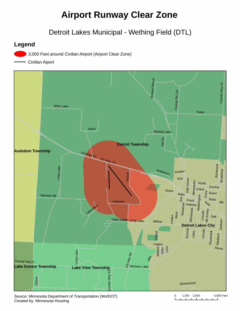
Detroit Township
Detroit Lakes City
Lake View Township
Audubon Township
Lake Eunice Township
US Hwy 10
Lake
US
Hw
y 59
Tower
Roo
seve
lt
Wes
t
County Hwy 6
Cou
nty
Hw
y 21
CentralSu
mm
it
Airp
ort
Was
hing
ton
Legion
Ros
sman
Wine Lake
Long
Lak
e
Clark GableOak
Union
Holmes
Main
Front
North
Willow
Monson Lake
Cur
ry
Cou
nty
Rd
131
232n
d
Min
neso
ta
Che
ryl
Old
Pit
8th
Jasch
State
Mad
ison
Longview
Elm
Jack
son
Soo
Anderson
Shore
Linc
oln
Brandy Lake
Ric
hwoo
d
Mitchell Hill
Bro
adw
ay
Brol
and
Beac
h
Mc
Kinl
ey
Gar
y
Villa
Cou
nty
Hw
y 19
Grant Oak
Gro
ve
Lind
en
Lakewood
Will
ard
Rud
Shorewood
Lynn
Juniper
Long
Lak
e
Grant
Linc
oln
US Hwy 10
Min
neso
ta
Long Lake
Detroit Lakes Municipal - Wething Field (DTL)
Airport Runway Clear Zone
Legend3,000 Feet around Civilian Airport (Airport Clear Zone)
Civilian Aiport
0 2,500 5,0001,250 FeetSource: Minnesota Department of Transportation (Mn/DOT)Created by: Minnesota Housing
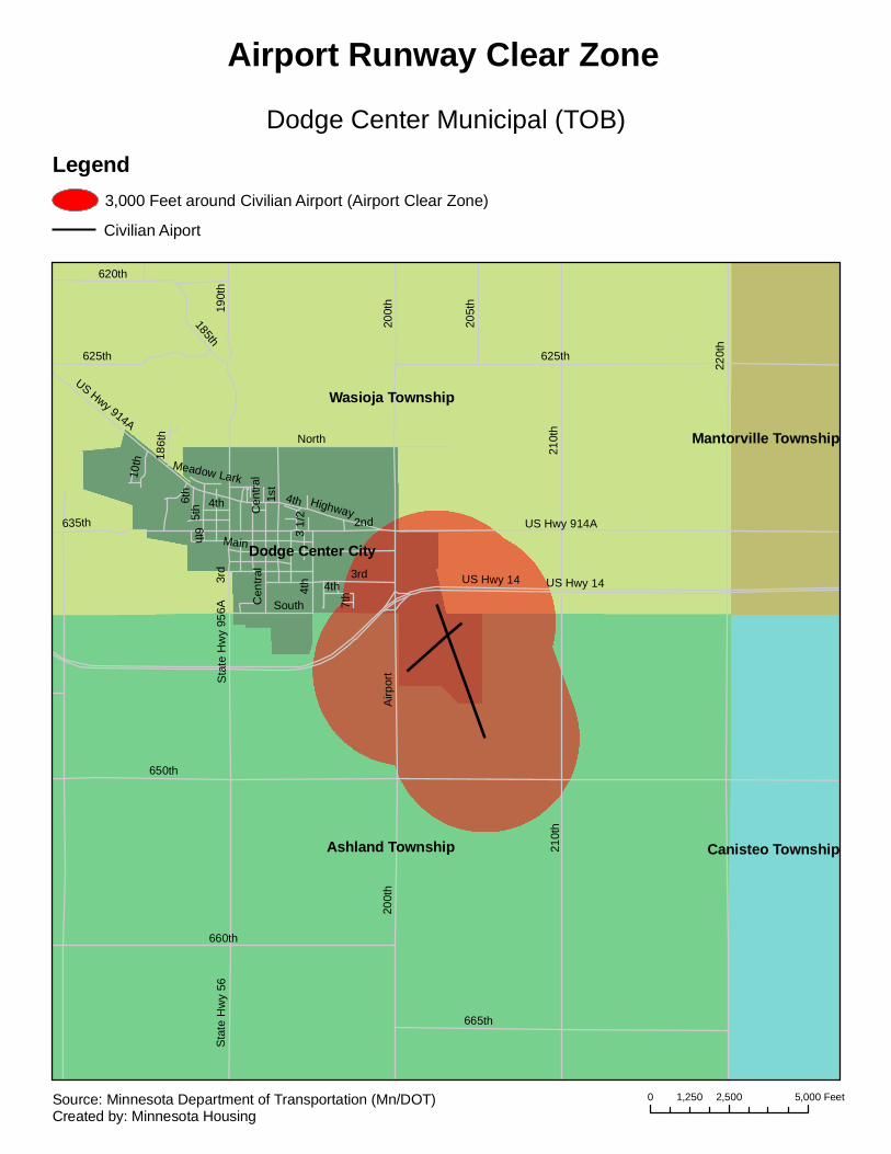
Ashland Township
Wasioja Township
Dodge Center City
Canisteo Township
Mantorville Township
220t
h
650th
210t
h
625th
US Hwy 14
660th
665th
200t
hA
irpor
t
1st
3rd
2ndMain
190t
h
US Hwy 914A
620th
Sta
te H
wy
56
North
Highway
4th
635th 5th
205t
h
185th
Cen
tral
South
6th
10th 18
6th
7th
Sta
te H
wy
956A
3 1/
2
Meadow Lark
Cen
tral
US Hwy 14
210t
h
4th
4th
US Hwy 914A
200t
h
4th
625th
3rd
6th
Dodge Center Municipal (TOB)
Airport Runway Clear Zone
Legend3,000 Feet around Civilian Airport (Airport Clear Zone)
Civilian Aiport
0 2,500 5,0001,250 FeetSource: Minnesota Department of Transportation (Mn/DOT)Created by: Minnesota Housing
Duluth City
Canosia Township
Hermantown Township
Rice Lake Township
Martin Rd
Mid
way
Rd
Ric
e La
ke R
d
W Arrowhead RdMiller Trunk Hwy
Hai
nes
Rd
Ugs
tad
Rd
Maple Grove Rd
Lava
que
Rd
Hermantown Rd
Ste
bner
Rd
How
ard
Gne
sen
Rd
I-35
Lind
ahl R
d
Anderson Rd
Get
chel
l Rd
Trin
ity R
d
Norton Rd
US Hwy 2
W Beyer Rd
Rose Rd
W Tischer Rd
W 3r
d St
W 1s
t St
Airport Rd
Industrial Rd
Kruger Rd
Piedmont Ave
W Calvary Rd
W S
kylin
e Pkw
y
Dec
ker R
d
Vaux
Rd
State Hwy 194
Luzerne Rd
S A
rling
ton
Ave
Kingston Rd
Mesaba Ave
Oke
rstro
m R
d
Seville Rd
Swan Lake Rd
Hutchinson Rd
Rei
nke
Rd
Airpark Blvd
Lava
que B
y-pas
s
Helm Rd
W Morgan St
W Ideal St
E Orange St
Gothenburg Rd
Kehtel Dr
Ken
woo
d Av
e
Samuelson Junction Rd
Hagberg Rd
Lockwood Rd
Willard RdFayre Rd
Ridgeview Rd
Fern
Ave
North Rd
Fiskey Rd
Woodhill La
Miller Rd
Springvale Rd
5th
Ave
S
Morris Thomas Rd
2nd
Ave
N
N 7th Ave E
Tom
ak D
r
Dan
iels
Rd
Patroy Rd
Peca
n Av
e
Middle Rd
Macfarlane Rd
John
son
Rd
Christianson Rd
Com
o Av
e
Wes
tbur
g R
d
3rd
Ave
S
San
gstro
m R
d
Radar Rd
W Marble St
S S
hore
Rd
E D
ahl R
d
Wilderness Tr
Quince St
Shelby Rd
Thur
ber R
d
Airp
ort A
ppro
ach
Rd
Lind
a R
d
Country Rd
James Bard Rd
Birc
h Va
lley
Rd
Wes
twoo
d R
d
Celia St
Beaver La
Wagner RdW 10th St
Sunnyview Rd
Joshua Ave
Kar
l Ave I-35
Lind
ahl R
d
Ugs
tad
Rd
Rose Rd
Lava
que
Rd
Lava
que
Rd
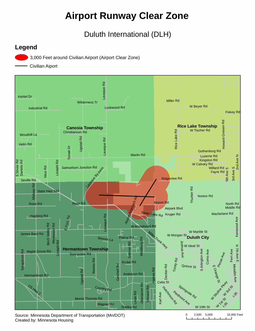
Duluth International (DLH)
Airport Runway Clear Zone
Legend3,000 Feet around Civilian Airport (Airport Clear Zone)
Civilian Aiport
0 5,000 10,0002,500 FeetSource: Minnesota Department of Transportation (Mn/DOT)Created by: Minnesota Housing

Darnen Township
Morris Township
Scott Township
Morris City
Pepperton Township
State Hwy 28
County Rd 68
6th
Cou
nty
Rd
63
Cou
nty
Hw
y 7
7th
Pacific
State Hwy 9
8th
4th
Idaho
9th
Northridge
Cou
nty
Rd
65
Atlantic
Par
k
Lyndale
5th
3rd
1st
Cou
nty
Rd
65
Morris Municipal (MOX)
Airport Runway Clear Zone
Legend3,000 Feet around Civilian Airport (Airport Clear Zone)
Civilian Aiport
0 2,500 5,0001,250 FeetSource: Minnesota Department of Transportation (Mn/DOT)Created by: Minnesota Housing
Sanford Township
Elbow Lake Township
Elbow Lake City
Pomme de Terre Township
Cou
nty
Rd
46
State Hwy 55
County Hwy 1
Sta
te H
wy
54
US
Hw
y 59
Cou
nty
Hw
y 4
Cou
nty
Rd
44
County Rd 42
County Hwy 25
1st St SE
County Rd 48
Cou
nty
Rd
47
2nd St NE
Park
Ave
3rd St SE
State Hwy 79Division St E
3rd St NW
Lake St
1st St NE
3rd St SW
3rd St NE
6th St SE
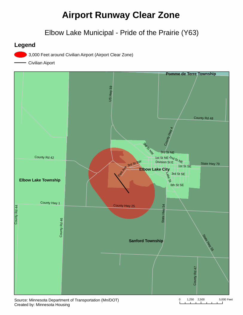
Elbow Lake Municipal - Pride of the Prairie (Y63)
Airport Runway Clear Zone
Legend3,000 Feet around Civilian Airport (Airport Clear Zone)
Civilian Aiport
0 2,500 5,0001,250 FeetSource: Minnesota Department of Transportation (Mn/DOT)Created by: Minnesota Housing
Morse TownshipFall Lake Township
Birch Lake UnorganizedStony River Township
State Hwy 1
Birc
h La
ke
Latv
a
Saari
County Hwy 120
Maijala
White Iron
Koski
Esterberg
Twp R
d 4564
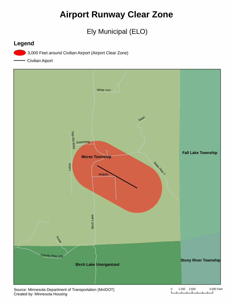
Ely Municipal (ELO)
Airport Runway Clear Zone
Legend3,000 Feet around Civilian Airport (Airport Clear Zone)
Civilian Aiport
0 2,500 5,0001,250 FeetSource: Minnesota Department of Transportation (Mn/DOT)Created by: Minnesota Housing
Fayal Township
Eveleth City Gilbert City
Clinton Township
Biwabik Township
Tikander Lake Unorganized
Leonidas City
US H
wy 53
Bodas Rd
Ely Lake Dr
W L
ong
Lake
Rd
Sparta Rd
State Hwy 37
S Airport Dr
Thunderbird Tr
N Airport Dr
Fayal Rd
Scout C
amp R
d
Cedar
Islan
d Bea
ch D
r
Elba Ave
Long Lake Rd
County Hwy 97
Miller Trunk Rd
River Rd
Hayes St
N Moon Lake Dr
Park DrWoodlawn Dr
Fayal Ave
Gol
f Cou
rse
Rd
S Peary Rd Dr
Superior St
Shady La
Monroe St
Station 44 Rd
Ple
asan
t La
N
Twp Rd 6712
Pleasant La
E L
ong
Lake
Dr
Horseshoe Rd
Plea
sant
Bay
Rd
Fayal Rd
US
Hw
y 53
Mill
er T
runk
Rd
Mille
r Tru
nk R
d
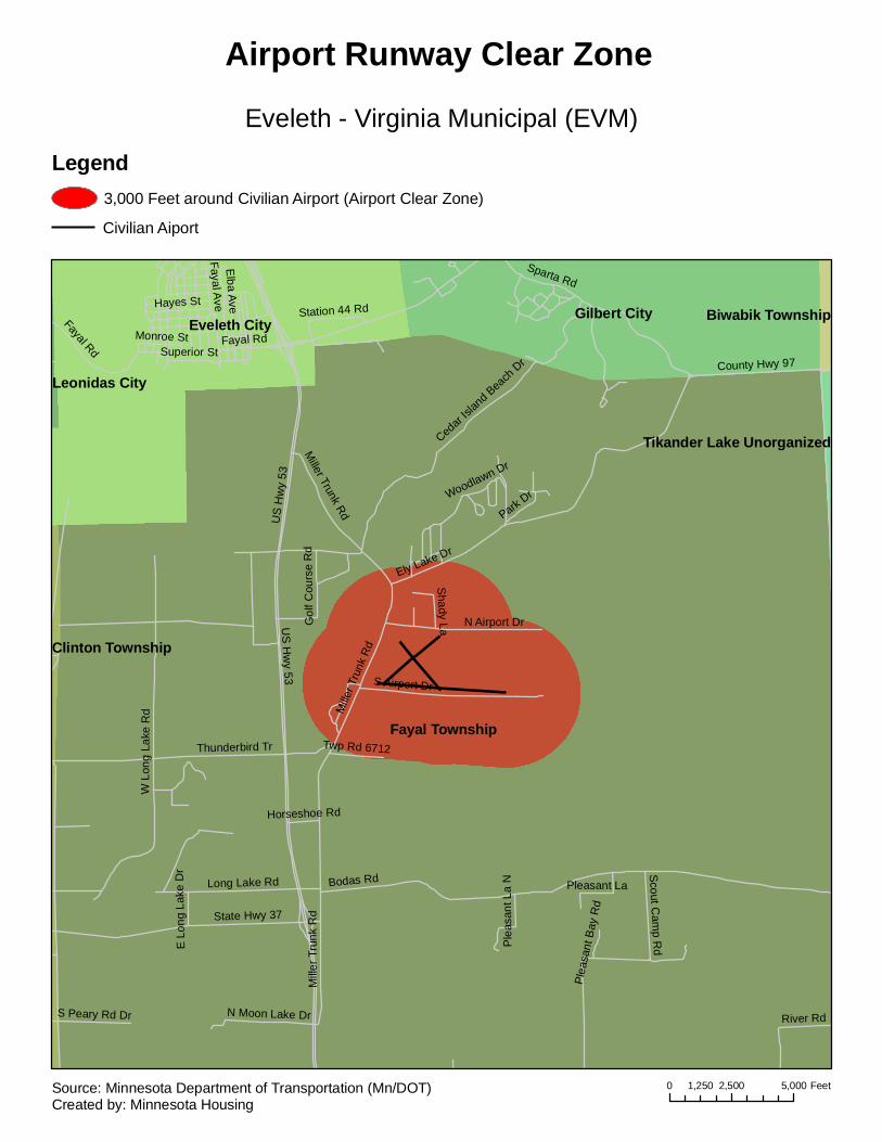
Eveleth - Virginia Municipal (EVM)
Airport Runway Clear Zone
Legend3,000 Feet around Civilian Airport (Airport Clear Zone)
Civilian Aiport
0 2,500 5,0001,250 FeetSource: Minnesota Department of Transportation (Mn/DOT)Created by: Minnesota Housing

Fairmont Township
Fairmont City
Rutland Township
I-90
90th
115th
Pra
irie
245t
h
Albi
on
Johnson
1st
Sta
te
10th
127th
230t
h
220t
h
95th
Nor
th
240t
h
105th
Main
Par
k
Winnebago
210t
h
Elm
2nd3rd
Hall
9th
4th
104th
8th
11th
125th
6th
Ham
pton
Orie
nt
Margaret
Day
225t
h
235t
h
12th
Gra
nt
Indu
s
5th
Anna
Bur
ton
Cou
nty
Rd
124
County Hwy 26
132nd
Cardinal
Dew
eyH
ighl
and
Hom
e
Lair
Stade
Red
woo
d
13th
Fairv
iew
Inci
nera
tor
7th
Teet
er
Adams
Clinic
Cou
nty
Hw
y 41
Lind
en
WaterFalcon
Spruce
Pin
e
Ward
Alton
Becky
Torgerson
Lake
Sioux
Dorothy
School
Belle Vue
Orie
nt
Sta
te
Dew
ey 2nd
Elm
Sta
te
95th
Par
k
Day
245t
h
I-90
Gra
nt
4th23
0th
12th
Fairmont Municipal (FRM)
Airport Runway Clear Zone
Legend3,000 Feet around Civilian Airport (Airport Clear Zone)
Civilian Aiport
0 2,500 5,0001,250 FeetSource: Minnesota Department of Transportation (Mn/DOT)Created by: Minnesota Housing
Wells Township
Faribault City
Cannon City Township
I-35
2nd
Aco
rn
4th
195th
Can
by
7th
Bag
ley
8th
3rd
Shieldsville
Hul
ett
160th
30th
Bel
view
20th
17th
9th
Cedar Lake
6th
Alv
ey
Rob
erds
Lak
e
Wes
tern
Cen
tral
13th
1st
Sta
te H
wy
21
165th
14th
Cul
ver
Par
k
Farib
ault
24th
11th
25th
Grant
16th
Becker
5th
170th
Linc
oln
Old 4th
Cardinal
Indu
stria
l
21st
State Hwy 60
Airtech
Rose
18th
Roberts Lake
Dover
180th
Bard
Delano
15 1/215th
19th
Airport
Irvin
g
Cannon
Fore
st
Cha
se
27th
I-35
Bec
ker
160th
8th
16th
19th
4th
1st
State Hw
y 21Par
kP
ark
5th
Park
170th
8th
Can
by
1st
165th
5th
14th
1st
8th
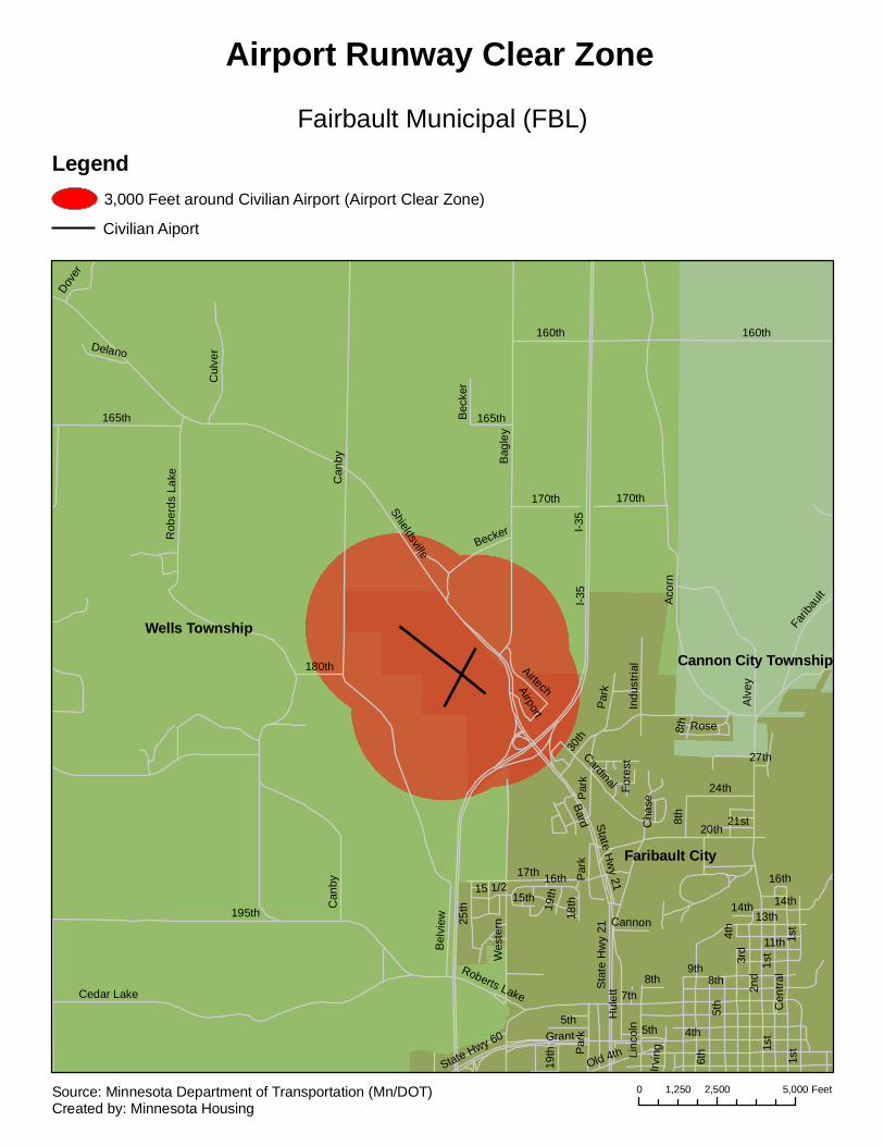
Fairbault Municipal (FBL)
Airport Runway Clear Zone
Legend3,000 Feet around Civilian Airport (Airport Clear Zone)
Civilian Aiport
0 2,500 5,0001,250 FeetSource: Minnesota Department of Transportation (Mn/DOT)Created by: Minnesota Housing

Orwell Township
Carlisle Township
Buse Township
Fergus Falls Township
Fergus Falls City
I-94
200th StCou
nty
Hw
y 15
State Hwy 210
Cou
nty
Rd
116
Cou
nty
Hw
y 21
155t
h A
ve
Cou
nty
Rd
114
210th St
Wes
tern
Ave
Cou
nty
Hw
y 86
Wyrens Rd
College Way
Fron
tier D
r
Riv
er O
aks
Blv
d
Riv
er O
aks
Dr
I-94Fergus Falls Municipal - Einar Mickelson Field (FFM)
Airport Runway Clear Zone
Legend3,000 Feet around Civilian Airport (Airport Clear Zone)
Civilian Aiport
0 2,500 5,0001,250 FeetSource: Minnesota Department of Transportation (Mn/DOT)Created by: Minnesota Housing

Brandsvold Township
Rosebud Township
King Township
Fosston City
Sletten Township
Hwy 2 SE
Trai
l Rd
SE
280th Ave SE
310th Ave SE
210t
h S
t SE
300th Ave SE
320th Ave SE
285th Ave SE
220t
h S
t SE
225t
h S
t SE
235t
h S
t SE
Lapi
er S
t SE
290th Ave SE
230t
h S
t SE
E 1st St
N F
oss
Ave
2nd St NE
2nd St NW
Columbia Rd SE
6th St NE
Hilligoss Blvd
Cou
nty
Hw
y 6
Indu
stria
l Ave
Frontage Rd
S M
ark A
ve
Par
k P
l
4th St NE
Hwy 2 SE
235t
h S
t SE
300th Ave SE
220t
h S
t SE
Hwy 2 SE
210t
h S
t SE
Fosston Municipal (FSE)
Airport Runway Clear Zone
Legend3,000 Feet around Civilian Airport (Airport Clear Zone)
Civilian Aiport
0 2,500 5,0001,250 FeetSource: Minnesota Department of Transportation (Mn/DOT)Created by: Minnesota Housing

Glenwood Township
Leven Township
Glenwood City
165th
200th
185th
State Hwy 28
145th
190th
170t
h
State Hwy 55
Cou
nty
Hw
y 29
160th
Cou
nty
Hw
y 21
195t
h
210t
h
County Hwy 22
180th
Amel
ia
Cou
nty
Hw
y 25
14th
1st
185t
h
200t
h
Glenwood Municipal (GHW)
Airport Runway Clear Zone
Legend3,000 Feet around Civilian Airport (Airport Clear Zone)
Civilian Aiport
0 2,500 5,0001,250 FeetSource: Minnesota Department of Transportation (Mn/DOT)Created by: Minnesota Housing

West Cook Unorganized
East Cook Unorganized
Grand Marais City
Gun
flint
County Hwy 8
County Rd 57
County Hwy 18
Cou
nty
Hw
y 6
Fore
st R
t 136
7
County Rd 64
County R
d 56
Cou
nty
Rd
55
County R
d 54
Grand Marais - Cook County (CKC)
Airport Runway Clear Zone
Legend3,000 Feet around Civilian Airport (Airport Clear Zone)
Civilian Aiport
0 5,000 10,0002,500 FeetSource: Minnesota Department of Transportation (Mn/DOT)Created by: Minnesota Housing
Harris Township
Grand Rapids City
Grand Rapids Township
La Prairie City
Unk
now
n or
No
Stre
etna
me
7th
River
6th
US Hwy 2
Harristown
Gun
n
10th
2nd
US
Hw
y 16
9
1st
Dav
is
Airp
ort
13th
Jess
Har
ry
8th
4th
9th
3rd
Mishawaka
21st
La P
airie
Trout Lake5th
11th
Pok
egam
a
Hor
sesh
oe L
ake
County Hwy 317
th
Wen
digo
Par
k
Golf Course
Fraser
Lily
Voge
s
Pleasant
15th
Mishawake
Pennala
32nd
Glenwood
Willow
Diane
Itasca
Sun
ny B
each
12th
Fern
30th
Wal
ter
Agn
es
20th
Hau
ser
Spruce
Donovan
18th
14th
Woodland
16th
7th
Pok
egam
a
13th
Fras
er
14th
3rd
6th
13th 8th5th
9th
11th
3rd
10th
10th
3rd
7th
1st
2nd
7th
5th
16th
14th
11th
9th
10th
8th
11th
2nd
3rd
4th
8th
6th
8th
17th
4th
River
1st
11th
6th
2nd
4th3rd10
th
14th
5th
12th
3rd
1st
9th
9th
4th
7th
10th
3rd
20th
7th
9th
1st
5th
Fraser
2nd
6th
8th
1st
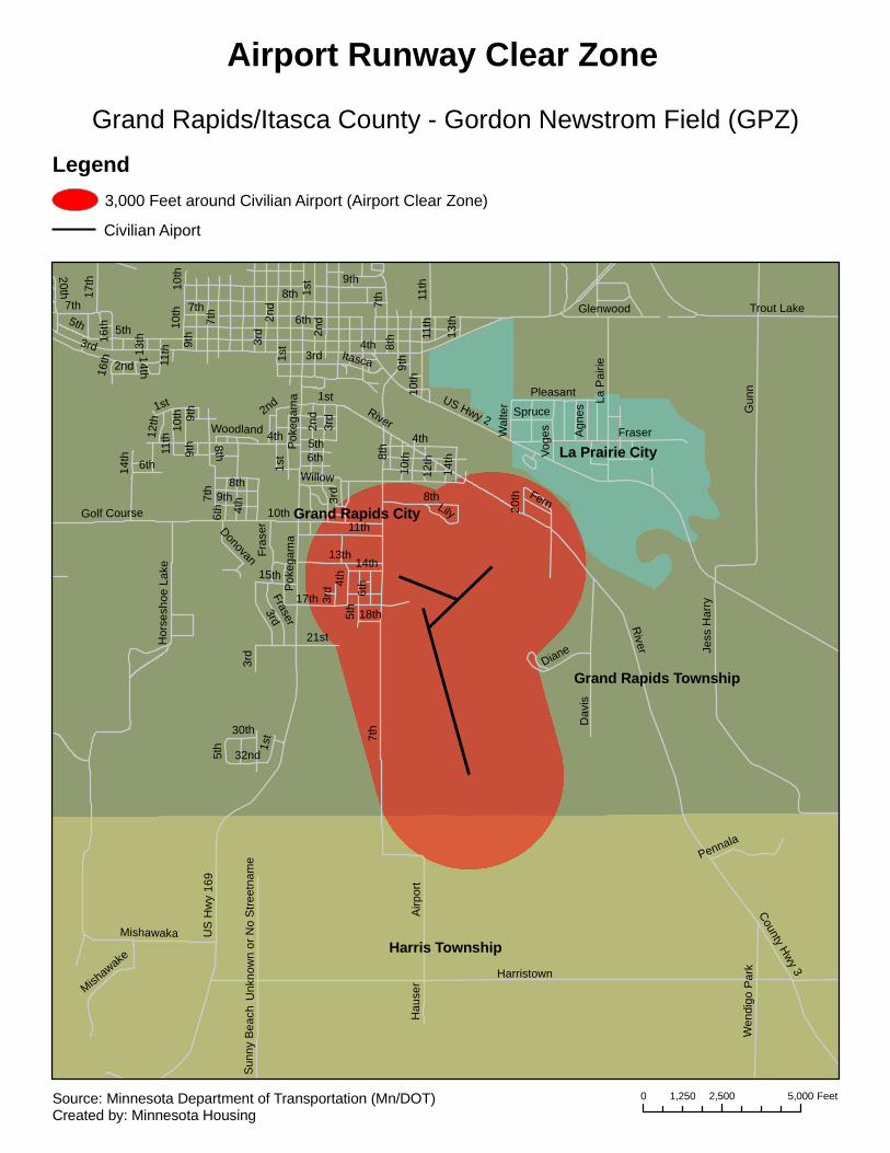
Grand Rapids/Itasca County - Gordon Newstrom Field (GPZ)
Airport Runway Clear Zone
Legend3,000 Feet around Civilian Airport (Airport Clear Zone)
Civilian Aiport
0 2,500 5,0001,250 FeetSource: Minnesota Department of Transportation (Mn/DOT)Created by: Minnesota Housing
Hallock Township Thompson Township
Hallock City
Skane Township
US H
wy 75
4thAtlantic
Cou
nty
Hw
y 13
Birch
County
Hwy 1
State Hwy 175
Bryan
County Hwy 10
County Hwy 22
3rd
Colum
bus
5th
County Hwy 33
Broadway
9th
2nd
8th
Em
erso
n
County R
d 74
7th6th
Douglas
Dew
ey
2nd State Hwy 175
2nd
4th
Cou
nty
Hw
y 1
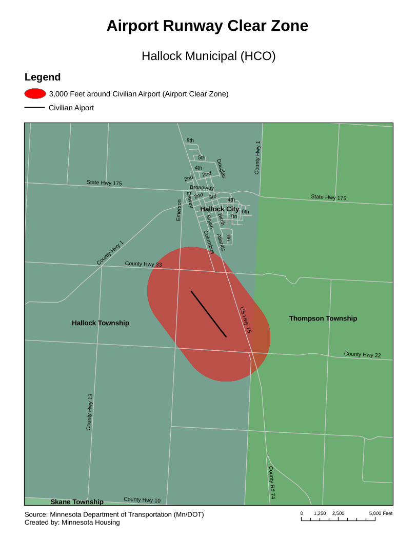
Hallock Municipal (HCO)
Airport Runway Clear Zone
Legend3,000 Feet around Civilian Airport (Airport Clear Zone)
Civilian Aiport
0 2,500 5,0001,250 FeetSource: Minnesota Department of Transportation (Mn/DOT)Created by: Minnesota Housing

Hawley Township
Cromwell Township
Hawley City
Eglon Township
US Hwy 10
5th
Main
6th
Rod
eo
County Rd 114
JosephC
ount
y H
wy
33
Cou
nty
Hw
y 31
7th
10th
Hartford
4th3rdReno
Front
Hobert
2nd
County Rd 115
8th
Wes
tgat
e
Valley
Sunset
US Hwy 10 5th
Hawley Municipal (04Y)
Airport Runway Clear Zone
Legend3,000 Feet around Civilian Airport (Airport Clear Zone)
Civilian Aiport
0 2,500 5,0001,250 FeetSource: Minnesota Department of Transportation (Mn/DOT)Created by: Minnesota Housing
Hector Township
Martinsburg Township
Hector CityMelville Township
Palmyra Township
810th
465t
h
490t
h
795th
770th
460t
h
485t
h
Highway
800th
3rd
470t
h
Sta
te H
wy
4
Cou
nty
Rd
67
Birch
780th
495t
h
Elm
Mai
n
Ash
Cou
nty
Hw
y 22
2nd
5th
Bryant
Cedar
FourUS Hwy 212
County Hwy 34
480t
h
US Hwy 212
Sta
te H
wy
4
780th
490t
h
2nd
3rd
460t
h
495t
h
770th
800th
Four
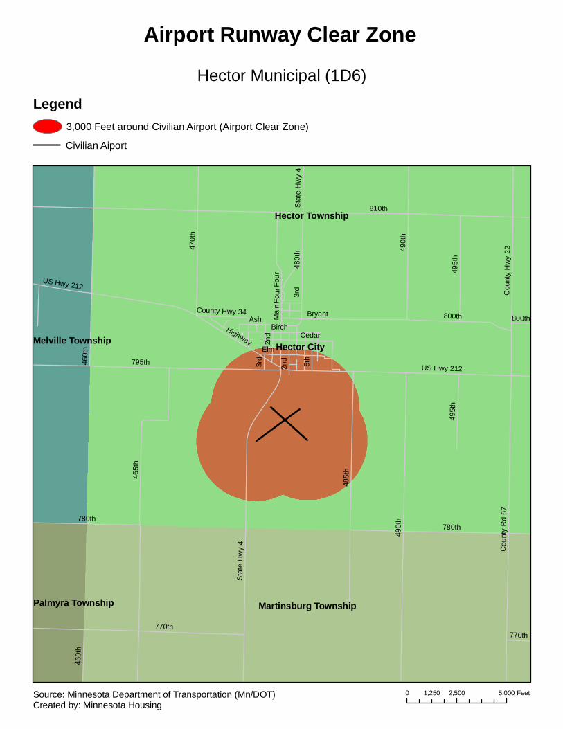
Hector Municipal (1D6)
Airport Runway Clear Zone
Legend3,000 Feet around Civilian Airport (Airport Clear Zone)
Civilian Aiport
0 2,500 5,0001,250 FeetSource: Minnesota Department of Transportation (Mn/DOT)Created by: Minnesota Housing
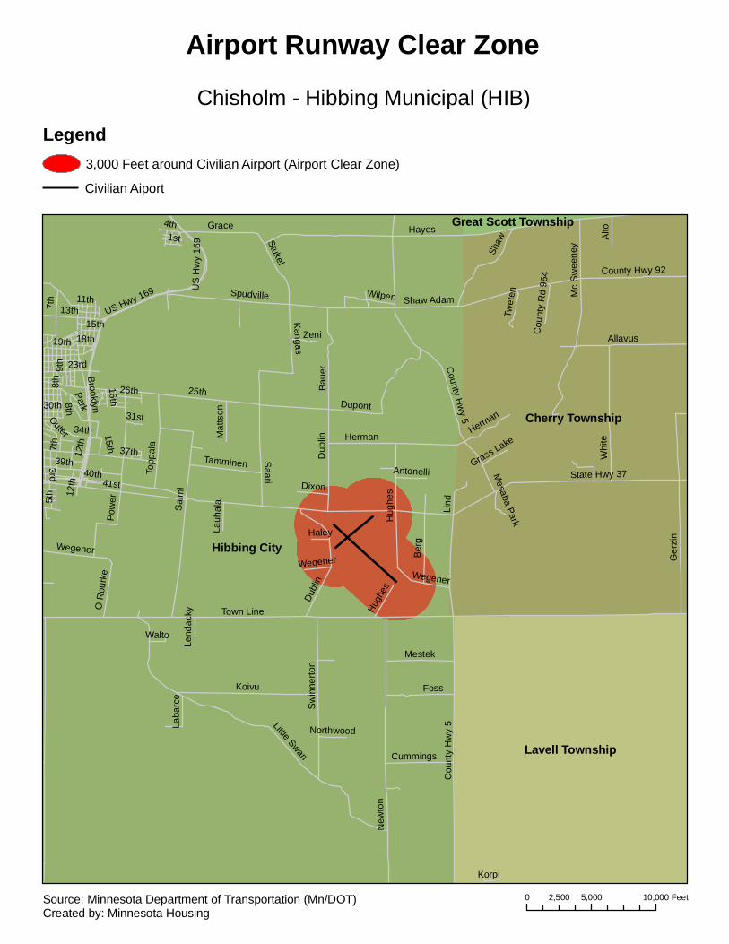
Hibbing City
Cherry Township
Lavell Township
Great Scott Township
25th
Town Line
Hayes
State Hwy 37
New
ton
Salm
i41st
Ger
zin
Little Swan
Cou
nty
Hw
y 5
37th
40th
Koivu
Spudville
Whi
te
US Hwy 169
Pow
er
Saari
39th
Allavus
Shaw
Dubl
inB
auer
Herman
Hug
hes
Shaw Adam Mc
Sw
eene
y
DupontB
erg
7th
9th
Sw
inne
rton
Foss
Kangas
Grace
23rd
Topp
ala
Stukel
13th
12th
Mestek
Lind5t
h
19th
Alto
Brooklyn
Wegener
County Hwy 92
Tamminen
11th
34th
Cummings
Park
Zeni
26th
O R
ourk
e
1st
Dixon
Twet
en
Mat
tson
30th
Laba
rce
Wilpen
18th
16th15th
31stOuter
Walto
3rd Antonelli
Lauh
ala
HaleyC
ount
y R
d 96
4
4th
Grass Lake
8th
Northwood
Lend
acky
Korpi
Mesaba Park
8th
12th
15th
Herman
Dub
lin
Hugh
es
Wegener
US
Hw
y 16
9
Wegener
County H
wy 5
7th
Chisholm - Hibbing Municipal (HIB)
Airport Runway Clear Zone
Legend3,000 Feet around Civilian Airport (Airport Clear Zone)
Civilian Aiport
0 5,000 10,0002,500 FeetSource: Minnesota Department of Transportation (Mn/DOT)Created by: Minnesota Housing
Lynn Township
Hutchinson City
Hassan Valley Township
Acoma Township Hutchinson Township
150th
Airport Jefferson
5th
Grade
2nd
York
145th
Dale
Plu
m
Sta
te H
wy
15
Ulm
160th
Cou
nty
Hw
y 7
4th
Lynn
Mai
n
125t
h
Century
Sch
ool
Roberts
Gro
ve
1st
Hassan
State Hwy 922A
Arch
Fran
klin
Ada
msLewis
Mer
rill G
len E
rie
Juul
Suns
et
Mon
roe
3rd
Oak
land
LindenLa
ke
Tagus
167t
h
Lake
wood
Mic
higa
n
8th
Kay
Elk
Stat
e H
wy
22
190th
Ran
ch
Alan
WashingtonAcoma
Sibley Milwaukee
Ech
o
Bra
dfor
d
155th
Jorg
enso
n
Kei
thHon
eytre
e
Rai
lroad
Gra
ham
Ivy
Denver
Tyle
r
Industrial
Harmony
Freemont
Bar
ley
Edmonton
Ont
ario
Rum
Atlanta
Jack
son
4th
Arch
4th3rd
160th
8th
Ran
ch
4th
1st
Gle
n
Ulm
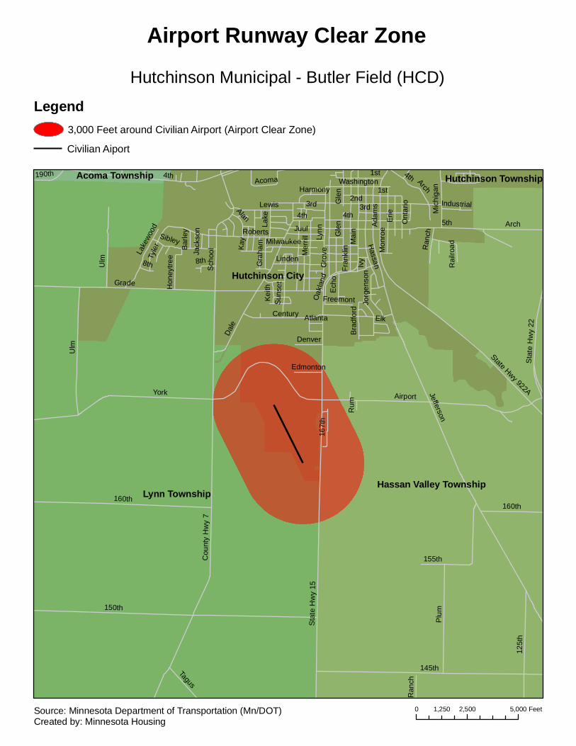
Hutchinson Municipal - Butler Field (HCD)
Airport Runway Clear Zone
Legend3,000 Feet around Civilian Airport (Airport Clear Zone)
Civilian Aiport
0 2,500 5,0001,250 FeetSource: Minnesota Department of Transportation (Mn/DOT)Created by: Minnesota Housing
Rainy Lake Unorganized
International Falls City
2nd
15th
US
Hw
y 53
Sta
te H
wy
11
1st
3rd
State Hwy 332
18th
9th
19th20th
11th
6th Mai
n
County Hwy 24
14th
Cou
nty
Hw
y 2
Keenan
7th
4th
Cre
sent
8th
5th
26th
23rd
ShorewoodCounty Rd 108
County Rd 107
County Hwy 7
Park
Cou
nty
Rd
69
10th
County Rd 105
Coun
ty R
d 10
6
County Rd 91
17th
Home
County Rd 152
Riverview
16th
21st
12th13th
Indus
trial
Frontage
Beyer
22nd
County Rd 121
Glenwood
Terrace
Valley Pine
16th
10th
11th 7th
6th
Fron
tage
3rd
15th
8th
2nd
1st
23rd
17th
Cou
nty
Hw
y 2
5th
13th
2nd12th
4th
10th
14th
4th
3rd
7th20th
15th
4th
10th
23rd
County Rd 108
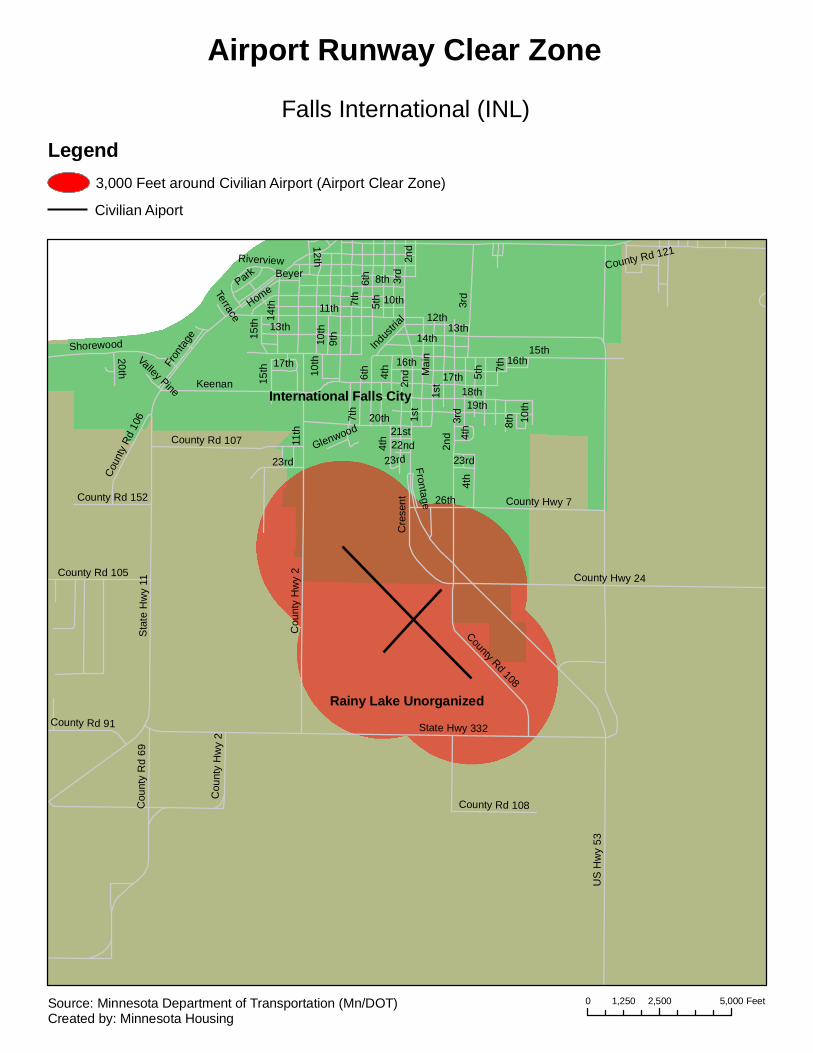
Falls International (INL)
Airport Runway Clear Zone
Legend3,000 Feet around Civilian Airport (Airport Clear Zone)
Civilian Aiport
0 2,500 5,0001,250 FeetSource: Minnesota Department of Transportation (Mn/DOT)Created by: Minnesota Housing

Des Moines Township
Wisconsin Township
Jackson City
Belmont Township Enterprise Township
I-90
US
Hw
y 71
Cou
nty
Rd
83
North
4thWhite
SpringfieldState
Ashley
County Hwy 14Rive
r
6th
County Hwy 34
Par
k
Riverside
South
Grant
1st
Cou
nty
Hw
y 23
3rd
Hills
Dew
ey
County Hwy 38
2nd
Emily
Cou
nty
Hw
y 51
Thomas Hill
Ray
Oak
Blu
ff
Moore
Center
Fros
t
Lee
Balla
rd
Kim
ball
Gill
eW
aller
County Hwy 34
I-90
County Hwy 14
1st
Jackson Municipal (MJQ)
Airport Runway Clear Zone
Legend3,000 Feet around Civilian Airport (Airport Clear Zone)
Civilian Aiport
0 2,500 5,0001,250 FeetSource: Minnesota Department of Transportation (Mn/DOT)Created by: Minnesota Housing
Ottawa Township
Lake Prairie Township
Le Sueur City
Sharon Township
Henderson Township Tyrone Township
Cou
nty
Hw
y 36
County Rd 115
Sta
te H
wy
112
Cou
nty
Rd
152
County Hwy 26
S 4t
h St
Elm
woo
d S
t Par
k La
County Rd 116Vine
St
N 4
th S
t
S 6
th S
t
King
sway
Dr
N M
ain S
t
Cou
rt St
Swan StS
2nd
StG
rove
St
S M
ain
StBridge St
County Rd 117
Oak St
Inner Dr
Cou
nty
Rd
63
Barony Rd
Ridge
Rd
Market St
Slack Dr
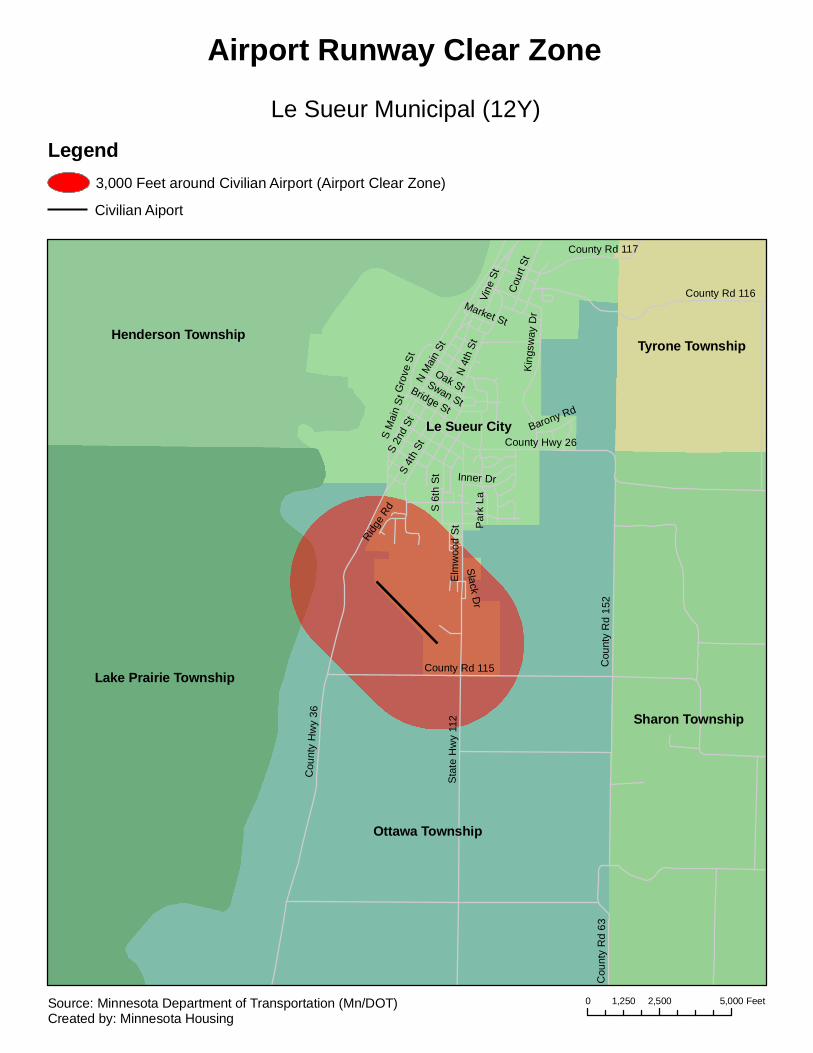
Le Sueur Municipal (12Y)
Airport Runway Clear Zone
Legend3,000 Feet around Civilian Airport (Airport Clear Zone)
Civilian Aiport
0 2,500 5,0001,250 FeetSource: Minnesota Department of Transportation (Mn/DOT)Created by: Minnesota Housing

Darwin Township
Litchfield Township
Litchfield City
Greenleaf Township Ellsworth Township
650t
h
5th
Depot
4th
250th
260th
3rd2nd
Sw
ift
6thS
ible
y
1st
230th
640t
h
615t
h
220th
628t
h
643r
d
Sta
te H
wy
22
240th
630t
h
Hol
com
be
Butler
Riple
y
255th
Pacific
Cou
nty
Hw
y 1
223rd
Lake Ripley
Mill
er
Quail
238th
620t
h
Pleasure
Aus
tin
245th
Gilm
an
Gor
man
Mar
shal
l
South
Ram
sey
Mea
dow
Arm
stro
ng
Yale
Hub
bard
235th
Litc
hfie
ld
Measure
253rd
Golf
Dav
is
Sunrise
Est
ates
Fulle
r
Park
Gei
nitzSt Paul
Bro
wn
Will
mar
Plea
sant
RipleyD
avis
245th
Gilm
an
Ripley
240th
230th
260th
6th
Litchfield Municipal (LJF)
Airport Runway Clear Zone
Legend3,000 Feet around Civilian Airport (Airport Clear Zone)
Civilian Aiport
0 2,500 5,0001,250 FeetSource: Minnesota Department of Transportation (Mn/DOT)Created by: Minnesota Housing
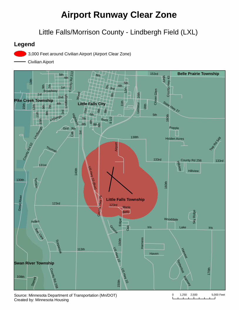
Little Falls Township
Little Falls City
Belle Prairie Township
Swan River Township
Pike Creek Township
140t
h
Iris
8th
7th
US H
wy 10
160t
h
153rd
9th
113th
13th
5th
123rd
170t
h
11th
2nd
County R
d 258
3rd4t
h
Gre
at R
iver
10th
Har
ness
Broadway
Harvest
138th
150t
h
State Hwy 27
133rd
Lake
12th
6th
US H
wy 10 (B
us)
15th
1stGolf
Airp
ort
Coun
ty R
d 52 Thomas
County Rd 256
Haven
Edg
ar
Cou
nty
Hw
y 43
108th
130th
Lem
ieur
Mary
Stan
ek
Hillview
Twp
Rd 54
8
Grouse
Cal
l
Timberlost
16th
9 1/
2
Woo
d
Lindb
ergh
Cou
nty
Hw
y 76
Cou
nty
Rd
213
Bay View
Highland
Betty
131st
Ramsey
Scepaniak
Marie
Buck
Hidden Acres
18th
WooddaleArden S
ky R
idge
Popple
Terrace
Linbergh
Clo
ver G
len
Oak
1st
8th 8th
1st
2nd
7th
Iris
Lind
berg
h
6th
8th7t
h
150t
h
Hillview
11th
3rd
9th
9th
6th
9th
160t
h
4th
5th
7th
4th
6th
5th
4th
123rd
133rd
US H
wy 10
12th
Little Falls/Morrison County - Lindbergh Field (LXL)
Airport Runway Clear Zone
Legend3,000 Feet around Civilian Airport (Airport Clear Zone)
Civilian Aiport
0 2,500 5,0001,250 FeetSource: Minnesota Department of Transportation (Mn/DOT)Created by: Minnesota Housing

Round Prairie TownshipLittle Sauk Township
Long Prairie TownshipReynolds Township
US
Hw
y 71
Midway
Old
No.
14
Trout Brook
Blackberg
Ang
le
Cen
ter L
ake
Maple Lake
School
County Hwy 48La
kevi
ew
State Hwy 27
Lake Latimer
Cottage
State Hwy 287
Sargents
County Rd 8
Hansman
Dusty
County Hwy 50
Cen
ter L
ake
Long Prairie - Todd Field (14Y)
Airport Runway Clear Zone
Legend3,000 Feet around Civilian Airport (Airport Clear Zone)
Civilian Aiport
0 2,500 5,0001,250 FeetSource: Minnesota Department of Transportation (Mn/DOT)Created by: Minnesota Housing
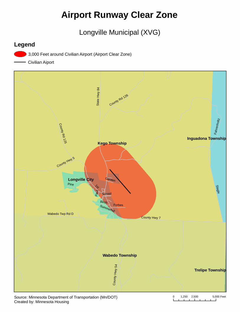
Kego Township
Wabedo Township
Longville City
Inguadona Township
Trelipe Township
Sta
te H
wy
84
1st
Slagle
Fahr
enho
ltzCounty Hwy 7
County R
d 125
Cou
nty
Hw
y 54
County Rd 126
County Hwy 5
Wabedo Twp Rd D
BirchForbes
School
Pine
Summerhill
Garden
Paul
Longville Municipal (XVG)
Airport Runway Clear Zone
Legend3,000 Feet around Civilian Airport (Airport Clear Zone)
Civilian Aiport
0 2,500 5,0001,250 FeetSource: Minnesota Department of Transportation (Mn/DOT)Created by: Minnesota Housing
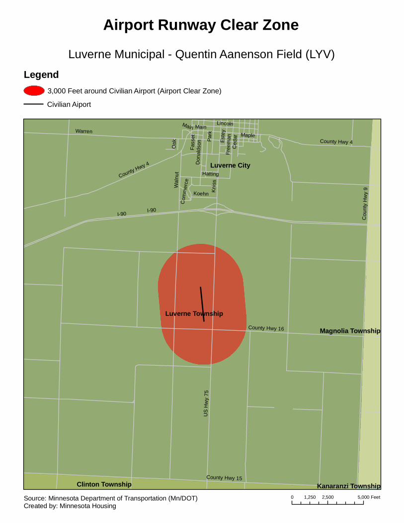
Luverne Township
Luverne City
Clinton Township
Magnolia Township
Kanaranzi Township
I-90
Warren
US
Hw
y 75
Cou
nty
Hw
y 9
County Hwy 15
Kni
ss
County Hwy 4
County Hwy 16
Lincoln
Wal
nut
Park
Free
man
Don
alds
on
Ced
ar Maple
Hatting
Este
y
Koehn
Oak
Com
mer
ce
Main
Fass
et
I-90
County Hwy 4
Main
Luverne Municipal - Quentin Aanenson Field (LYV)
Airport Runway Clear Zone
Legend3,000 Feet around Civilian Airport (Airport Clear Zone)
Civilian Aiport
0 2,500 5,0001,250 FeetSource: Minnesota Department of Transportation (Mn/DOT)Created by: Minnesota Housing

Madison Township
Hamlin Township
Madison City
Arena TownshipU
S H
wy
75
1st 8th
6th
County Hwy 16
State Hwy 40
9th
4th
5th
Par
k
11th
County Hwy 14
10th
3rd
7th
Cou
nty
Rd
65
2nd
9th
State Hwy 40
3rd
Madison - Lac Qui Parle County (DXX)
Airport Runway Clear Zone
Legend3,000 Feet around Civilian Airport (Airport Clear Zone)
Civilian Aiport
0 2,500 5,0001,250 FeetSource: Minnesota Department of Transportation (Mn/DOT)Created by: Minnesota Housing
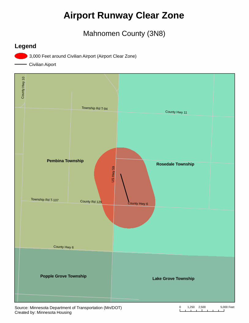
Rosedale TownshipPembina Township
Lake Grove TownshipPopple Grove Township
US
Hw
y 59
County Hwy 6
County Hwy 11
County Rd 129
Township Rd T-94
Township Rd T-107
Cou
nty
Hw
y 10
County Hwy 6
Mahnomen County (3N8)
Airport Runway Clear Zone
Legend3,000 Feet around Civilian Airport (Airport Clear Zone)
Civilian Aiport
0 2,500 5,0001,250 FeetSource: Minnesota Department of Transportation (Mn/DOT)Created by: Minnesota Housing
Kasota Township
Lime Township
Mankato City Le Ray TownshipMankato Township
Jamestown Township
Washington Township
Cleveland Township
Eagle Lake City
Oshawa Township Kasota City
North Mankato City
Belgrade Township
US Hwy 14
4th
5th
Main
3rd
County Hwy 17
6th
County Hwy 26
County Hwy 2
Cou
nty
Hw
y 27
Sta
te H
wy
22MadisonBroa
d
Riverfront
Fair
7th
Lim
e Va
lley
Pfa
u
Ty
Cou
nty
Hw
y 5
Belle
1st
Marsh
Cou
nty
Rd
188
County Hwy 3
Sta
te H
wy
60County Hwy 12
Glenwood Hoffman
Le Ray
Age
ncy
Long
Adams
Lind
Pine
Summit
Cou
nty
Rd
186
Industrial
County Rd 187
Pre
mie
r
Wayside
8th
Pohl
Fron
tA
Malin
River
May
Monks
Mable
Par
k
Lewis
Thompson Ravine
Exc
el
Augusta
Mulberry
DavisPleasant
Belleview
Cameo
Bee
ch5t
h
Cou
nty
Rd
186
5th
US Hwy 14
County Rd 187
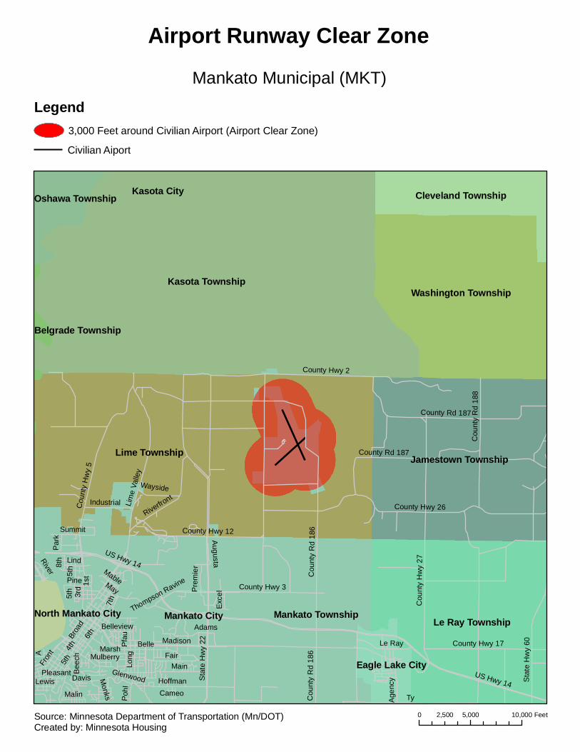
Mankato Municipal (MKT)
Airport Runway Clear Zone
Legend3,000 Feet around Civilian Airport (Airport Clear Zone)
Civilian Aiport
0 5,000 10,0002,500 FeetSource: Minnesota Department of Transportation (Mn/DOT)Created by: Minnesota Housing

Marshall City
Lynd Township
Fairview Township
Lake Marshall Township
Grandview Township
4th
7th
Erie
Main
College
State Hwy 23
A
5th Bru
ce
1th
US
Hw
y 59
Field
State Hwy 68
2nd
Channel
County Rd 76
Country
1st
Sar
atog
a
F
Cou
nty
Hw
y 7
High
State Hwy 19
Lyon
C
Elaine
3rd
B
Donita Viki
ng
Elm
GH
ill
Lond
on
Cou
nty
Rd
67
Marshall
Legi
on F
ield
Kossuth
County Rd 74
6th
Camden
11th
Par
k
Hah
n
Hal
bur
Fairgro
unds
Fairview
Che
ryl
Pine
Sup
erio
r
Whitney
KathrynWestwood
Lynd
Oak
George
Genesis
Col
umbi
ne
Robert
8th
Greeley
Pat
ricia
Lake
Soucy10th
Maple
Ridgeway
Ken
nedy
Southv
iew
PaulW
oodf
ern
County Rd 74
Cha
nnel
Cha
nnel W
hitn
ey
Southwest Minnesota Regional Marshall/Ryan Field (MML)
Airport Runway Clear Zone
Legend3,000 Feet around Civilian Airport (Airport Clear Zone)
Civilian Aiport
0 2,500 5,0001,250 FeetSource: Minnesota Department of Transportation (Mn/DOT)Created by: Minnesota Housing
Eureka Township
Lakeville City Farmington City
Ced
ar A
ve
Dod
d B
lvd
225th St W
215th St W
Hig
hvie
w A
ve
Flag
staf
f Ave
235th St W
202nd St W
Hol
yoke
Ave
212th St W
240th St W
Ham
burg
Ave
245th St W
207th St W
200th St W
Lakeville Blvd
Iberia Ave
Kenwood Tr
Italy
Ave
199th St W
Gre
nada
Ave
Jacq
uard
Ave
Upper 205th St W
210th St W
215th St
Icalee Path
Indi
a A
ve
205th St W
Junco Tr
219th St W
Iran
Ave
Hya
cint
h Av
e Heron Way
Idal
ia A
ve
Hul
l Ave
Heritage Dr
Hey
woo
d Av
e204th St W
Jersey Ct
Ideal Way
Icel
and
Ave
Illin
ois
Path
Hem
lock
Ave
Ced
ar A
ve
240th St W
200th St W
212th St W
235th St W
Ham
burg
Ave
245th St W
Hig
hvie
w A
ve
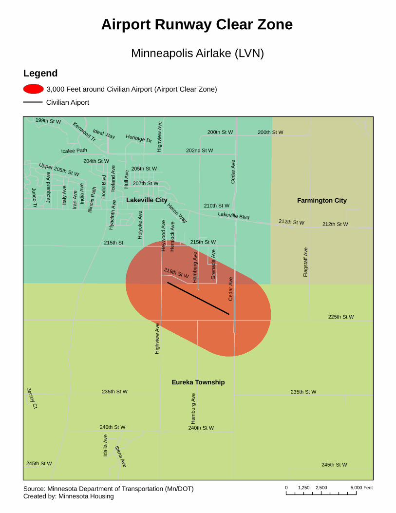
Minneapolis Airlake (LVN)
Airport Runway Clear Zone
Legend3,000 Feet around Civilian Airport (Airport Clear Zone)
Civilian Aiport
0 2,500 5,0001,250 FeetSource: Minnesota Department of Transportation (Mn/DOT)Created by: Minnesota Housing

Blaine City
Mounds View CitySpring Lake Park City Shoreview City
Lexington City
85th
Cen
tral
Pol
k
I-35W
109th
81st
89th
99th
US Hwy 10
101st
79th
113th
5th
Lovell
Radiss
on
Nap
les
105th
Rode
o
82nd
Xyl
ite
95th
Lake
US Highway 10
93rd
97th
Manor
Plaza
Dav
enpo
rt
84thIone
83rd
Able
91stH
amlin
e
Bal
timor
e
96th
Qui
ncy
35w
Ser
vice
87th
Airp
ort
Terr
ace
111th
Jack
son
FlowerfieldHigh
wayIsan
ti Bat
aan
114th
6th
7th
Tyle
r
Cloverleaf
Buch
anan
94th
Grig
gs
Dun
lap
Fillm
ore
Territorial
Flan
ders
Yalta
Stat
e H
wy
65
Edgewood
Oak
Sun
set
108th
Uly
sses
Nassau
88th
RestwoodX
ebecH
astin
gs
115thA
rthur
Linc
oln
Cen
ter
Pre
side
nts
Aro
na
Rendova
107th
Van
Bur
en
80th
Pie
rce
110th
98th
90th
Sanctuary
Arnold Palmer
78th
104th
Aus
tin
103rd
Edison
10th
Mon
roe
92nd Rya
n
Dunkirk
112th
Pas
cal
John
son
Ala
mo
Harpers
Mck
inle
yE
ldor
ado
Dee
Was
hingt
on
Goo
dhue86th
Rosedale
Tayl
or
President
Mad
ison
Wac
onia
Jeffe
rson
Deer
100th
Pleasure Creek
Man
kato
Club W
est
106th
Cor
al S
ea
Zumbrota
102nd
Palisade
Urbank
Holland
78th Street
Zum
brot
a
Abl
e
104th
99th
Abl
e
92nd
Abl
e
93rd
95th
Terrace
111th
93rd
Dav
enpo
rt
Cen
tral
Flan
ders
7th
Pie
rce
Xyl
ite
107th
88th89th
Cen
tral
99th
107th
Tyler
Har
pers
Bal
timor
e
Fillmore
96th
Bal
timor
e
98th
US Hwy 10
87th
Flanders
Dun
lap
Bal
timor
eB
altim
ore
91st
Qui
ncy
108th
83rd
Nap
les
Polk
7th
I-35W
Alam
o
Qui
ncy
99th
Tyle
r
Edi
son
Tyle
r Cen
tral
101st
Uly
sses
88th
99th
109th
Terra
ce
Central
98th98th
83rd
Airp
ort
93rd
85th
Clu
b W
est
107th
101st
Tyle
r
90th91st
Xyl
ite
Ala
mo
Nas
sau
111t
h
78th
105th
92nd
Cent
ral
101st
6th
89thYa
lta
95th
Terr
ace
96th
106th
107th
91st
Goodhue
80th
87th
Radisson
I-35W
Lois
Ardan
US Hwy 10
Red
Oak
Sherwood
Eas
twoo
d
Spr
ing
Lake
84th
Gro
vela
nd
82nd
Terrace
Hillview
Parkview
Long
Lak
e
Fairc
hild
Sch
utta
Oakwood
Ric
e C
reek
Woo
dlaw
n
Sne
lling
Edg
ewoo
d
Knoll
Kno
llwoo
d
Sun
nysi
de
Gre
enw
ood
Lexi
ngto
n
Hillview
US Hwy 10
Oakwood
I-35W
Sun
nysi
de
Fairc
hild
Lois
Minneapolis Anoka County/Blaine - Janes Field (ANE)
Airport Runway Clear Zone
Legend3,000 Feet around Civilian Airport (Airport Clear Zone)
Civilian Aiport
0 2,500 5,0001,250 FeetSource: Minnesota Department of Transportation (Mn/DOT)Created by: Minnesota Housing
Brooklyn Park City
Crystal City
Brooklyn Center City
New Hope City
Robbinsdale City
Minneapolis City
Maple Grove City
I-94
63rd
Boo
ne
US
Hw
y 16
9
62nd
County Hwy 81
42nd
Brooklyn
69th
49th
Xerxes
Zane
State Hwy 100
Fran
ce
York
Ada
ir
Broadw
ay
71st
June
Lakeland
76th
57th
Iris
New
ton
65th
Jolly
73rd
Zeni
th
40th
Ham
pshi
re
Que
bec
Pen
n
Lake
Bea
rd
64th
Osseo
Bass Lake
Douglas P
erry
Bethia
I-694
46th
Que
en
Shingle Creek
43rd
Abb
ott
Modern
Rus
sell
Loga
n
Aster
44th
Thom
as
Idah
o
Sum
ter
Oliv
er
Kyl
e
41st
Freeway
39th
She
ridan
Kilmer
67th
Aqu
ila 45th
56th
Cho
wen
52nd
Bru
nsw
ick
Get
tysb
urg
Florida
55th
Xyl
on
53rd
Grim
es
40 1/2
Geo
rgia
Lee
66th
Mor
gan
48th
Edg
emon
t
58th
Jord
an
Hubbard
Del
72nd
Tole
do
Xen
ia
Lilac
70th
Flag
Ore
gon
60 1/260th
68th
Old O
sseo
Twin Lake
Brookdale
54th
Nor
thla
nd
61 1/2
Win
netk
a
Vera
Cru
z
Unity
50th
Ken
tuck
y
61st
59th
75th
Dudley
Jersey
Scott
Zeal
and
Col
orad
oRegent
47th
Cav
ell
Ew
ing
Joyce
78thH
alifax
51st
Drew
74th
Estate
Noble
Century
Ens
ign
38th
77th
Utah
Sun
ny
Qua
il
Men
dels
sohn
Dutton
Edg
ewoo
dHartkopf
47 1/2
Dec
atur
Yate
s
John Martin
Yuko
n
Brookview
County Hwy 130
Winchester
Imperial
Nev
ada
Jane
ll
Dec
ator
Corvallis
Orchard
Was
hbur
n
Poe
Science Center
Sailor
Woodbine
Rho
de Is
land
SummitBrook
Lake Breeze
Hopewood
Mar
ylan
d
Upt
on
Tess
man Teton
Hillsbo
ro
Admiral
Wel
com
e
Loui
sian
a
Vinc
ent
Indi
ana
Angeline
St Raphael
Erickson
Crystal
Fairview
Maj
or
Cherokee
Wis
cons
in
46 1/2
BoulderBass Creek
Pen
nsyl
vani
a
45th 1/2
Brentwood
Burquest
Lombardy
Rockford
Cloverdale
Lakeside
74th 1/2
Commodore
Robin
County Rd 81
43rd
75th
73rd
Dre
w
45th
Xer
xes
Sco
tt
Twin
Lak
e
Qua
il
Edg
ewoo
d
67th
41st
Maj
or
France
74th
Loui
sian
a
46th
Reg
ent
70th
Zeni
th
Beard
78th
Jers
ey
67th
Yate
s
65th
Yuko
n
53rd
Bro
adw
ay
73rd
51st
Dou
glas
66th
Xer
xes
59th
48th
67th
Cav
ell
74th
Hill
sbor
o
44th
Xylon
64th
County Hwy 81
39th40th
39th
Jers
ey
Utah
Fran
ce
75thM
ajor
52nd
Mar
ylan
d
40th
56th
46th
Per
ry
Oliv
erP
enn
47th
Sumter
68th
47th
40th
Que
en
71st
Zane
77th
48th
50th
59th
Orchard
State Hwy 100
68th
Yate
s
60th
US
Hw
y 16
9
52nd
73rd
61st
Perry
58th
Uni
ty
Vinc
ent
York
68th
Hill
sbor
o
Reg
ent
41st
Yuko
n
Bru
nsw
ick
43rd
Xen
ia
57th
65th
Qua
il
Lee
70th 70th
50th
44th
55th
40th
69thW
elco
me
71st
57th
73rd
Zeal
and
67th
Jers
ey
46th
52nd
Nob
le
50th
58th
51st
Flag
I-94
Ewin
g
53rd
Beard
50th
Beard
45th
Mor
gan
46th
41st
Quail
74th
59th
73rd
Oliv
er
Per
ry
56th
53rd
Scott
Uta
h
Fran
ce
Xer
xes
Lee
Xylon
66th
51st
61st
60th
Nob
le
Sco
ttTo
ledo
64th
54th
41st
Lakeside
41st
56th
52nd
47 1/2
Idah
o
68th
46th
61st
60th
Ore
gon
64th
68th
Fairview
47th
54th
Uni
ty
39th
76th
Douglas
Idah
o
43rd
77th
53rd
65th
58th
Indiana
40th
39th
49th
67th
Zane
67th
48th
39th
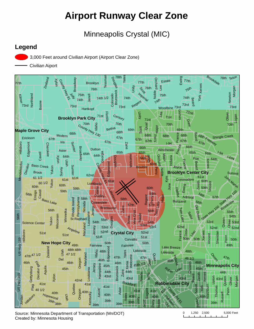
Minneapolis Crystal (MIC)
Airport Runway Clear Zone
Legend3,000 Feet around Civilian Airport (Airport Clear Zone)
Civilian Aiport
0 2,500 5,0001,250 FeetSource: Minnesota Department of Transportation (Mn/DOT)Created by: Minnesota Housing
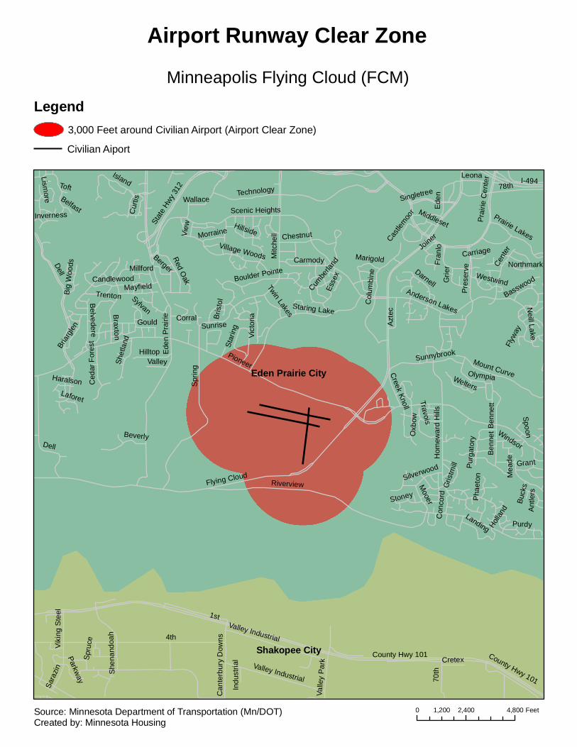
Eden Prairie City
Shakopee City
Pioneer
Dell
Mitc
hell
Spr
ing
Flying Cloud
78th
Riverview
Ede
n P
rairi
e
Anderson Lakes
Technology
Hom
ewar
d H
ills
I-494
Braxton
Staring Lake
Pre
serv
e
Col
umbi
ne
Cent
er
Prai
rie C
ente
r
Scenic Heights
Village Woods
Ede
n
Mount Curve
Carmody
Purdy
Stat
e Hw
y 312
Mea
de
Chestnut
Vict
oria
Hilltop
Beverly
Sunnybrook
Candlewood
Ben
net
Island
Azt
ecWelters
Boulder Pointe
Gould
Wallace
Fran
lo
Red Oak G
rier
Grant
Darnell
Prairie Lakes
Belvedere
Singletree
Mayfield Cumbe
rland
Mooer
Olympia
Leona
Ben
nett
Trenton
Purg
ator
yOxb
ow
Briar
glen
Landing
Hillside
Silverwood
Ant
lers
Travois
Valley
Esse
x
Berger
Creek Knoll
Neill Lake
Star
ing
Gris
tmill
Shet
land
Cur
tis
Ced
ar F
ores
t
View
Northmark
Big
Woo
ds
Twin Lakes
Morraine
Laforet
Sunrise
Phae
ton
Joiner
Millford
Con
cord
Marigold
Corral
Westwind
Sylvan
Stoney
Inverness
Basswood
Bris
tol
Spoon
Carriage
Haralson
Toft
Castle
moor
Lismore Belfast
Windsor
Flyw
ay
Holla
nd
Middleset
Buck
s
Dell
1st
4th
County Hwy 101
70th
Valley Industrial
Sara
zin She
nand
oah
Parkway
Valle
y Pa
rk
Can
terb
ury
Dow
ns
Cretex
Viki
ng S
teel
Spru
ce
Indu
stria
l County Hwy 101
Valley Industrial
Minneapolis Flying Cloud (FCM)
Airport Runway Clear Zone
Legend3,000 Feet around Civilian Airport (Airport Clear Zone)
Civilian Aiport
0 2,400 4,8001,200 FeetSource: Minnesota Department of Transportation (Mn/DOT)Created by: Minnesota Housing

Minneapolis City St. Paul City
Eagan CityBloomington City
Fort Snelling UnorganizedRichfield City
Mendota Heights City
Mendota City
Lilydale City
12th
Por
tland
I-494
28th
54th
86th
3rd
56th
79th
4th
66th
46th
38th
67th68th
75th76th
90th
84th
31st
52nd51st
State Hwy 62
77th
11th
10th
43rd
Hiawatha
40th
49th
60th
27th
61st
30th
13th
44th
69th
Ced
ar
72nd
45th
5th
34th
88th
53rd
39th
26th
58th
14th
37th
35th
36th
Riv
er
78th
42nd
55th
18th
29th
Sta
te H
wy
77
71st
Clin
ton
70th
Post
Old
Ced
ar
41st
Par
k
16th
25th
17th
Stat
e Hw
y 5
Chi
cago
80th
32nd
59th
33rd
83rd
Long
fello
w
Col
umbu
s
Blo
omin
gton
Oak
land
State Hwy 55
62nd
Woo
dlaw
n
64th
Airport
23rd
Snelling
63rd
19th
FordLake Nokomis
24th
74th
22nd
South
Lindau
Godfrey
Diagon
al
21st
47th
89th
87th
82nd
15th
73rd
Elli
ot
20th
57th
Luve
rne
Standish
Edgewater
50th
81st
Minnehaha
48th
Metro
Mar
ket
Nokomis
65th
Ald
rich
Riverview
Old Shakopee
International
Roslyn 59th 1/2
Sand
er
15th
78th
15th
29th
26th
41st
50th50th
11th
45th
78th
Chi
cago
24th
33rd
63rd
54th
52nd
Ced
ar
5th
17th
51st
16th
4th
36th
78th 78th
11th
16th
70th
12th
81st
16th
State Hwy 55
13th
12th
13th
81st
5th
24th
5th
31st
71st
18th
31st
13th
53rd
10th 22
nd
Park
14th
Col
umbu
s
4th
Long
fello
w
Minnehaha
37th
82nd
30th
Elli
ot
26th
Clin
ton
16th
34th
29th
I-494
State Hwy 62
11th
4th
16th
45th
16th
Oak
land
10th
Clin
ton
17th
28th
Clin
ton
13th
62nd
50th49th
Ced
ar19
th
15th
88th
Col
umbu
s
Stat
e Hw
y 5
69th
46th
Oak
land 14
th
44th
80th
18th
43rd
59th
17th
45th
47th
16th
78th
Par
k
46th56th
Par
k
Elli
ot
18th
Nok
omis
Clin
ton
5th
5th
15th
13th
82nd
Ced
ar
14th
35th
55th
58th
78th
11th
64th
44th
42nd
43rd
I-494
Stat
e H
wy
13
State Hw
y 55
I-35E
D St
Lone Oak Rd
Pilo
t Kno
b R
d
Northland Dr
State Hwy 110
Trap
p R
d
Skyline Rd
Jurdy Rd
Enterprise Dr
Red Cedar Rd
Skyline Dr
2nd St
Highview Ave
High Site Dr
I-494
I-35E
7th
Dav
ern
Sne
lling
FordHighland
Shepard
Fairv
iew
How
ell
Rome
Stewart
Saint Paul
Montreal
Mississippi R
iver
Cre
tin
Cle
vela
nd
Bohland
Ham
lineAlb
ert
Syn
dica
te
Sheridan
Eleanor
Mac
ales
ter
Ret
urn
Norfolk
Hartford
Yorkshire
Bayard
JunoNiles
Mou
nt C
urve
Edgcumbe
Munster
Rankin
Colvin
Ken
neth
Finn
Finn
Ken
neth
Juno
Shepard
Minneapolis - St. Paul International (MSP)
Airport Runway Clear Zone
Legend3,000 Feet around Civilian Airport (Airport Clear Zone)
Civilian Aiport
0 3,000 6,0001,500 FeetSource: Minnesota Department of Transportation (Mn/DOT)Created by: Minnesota Housing
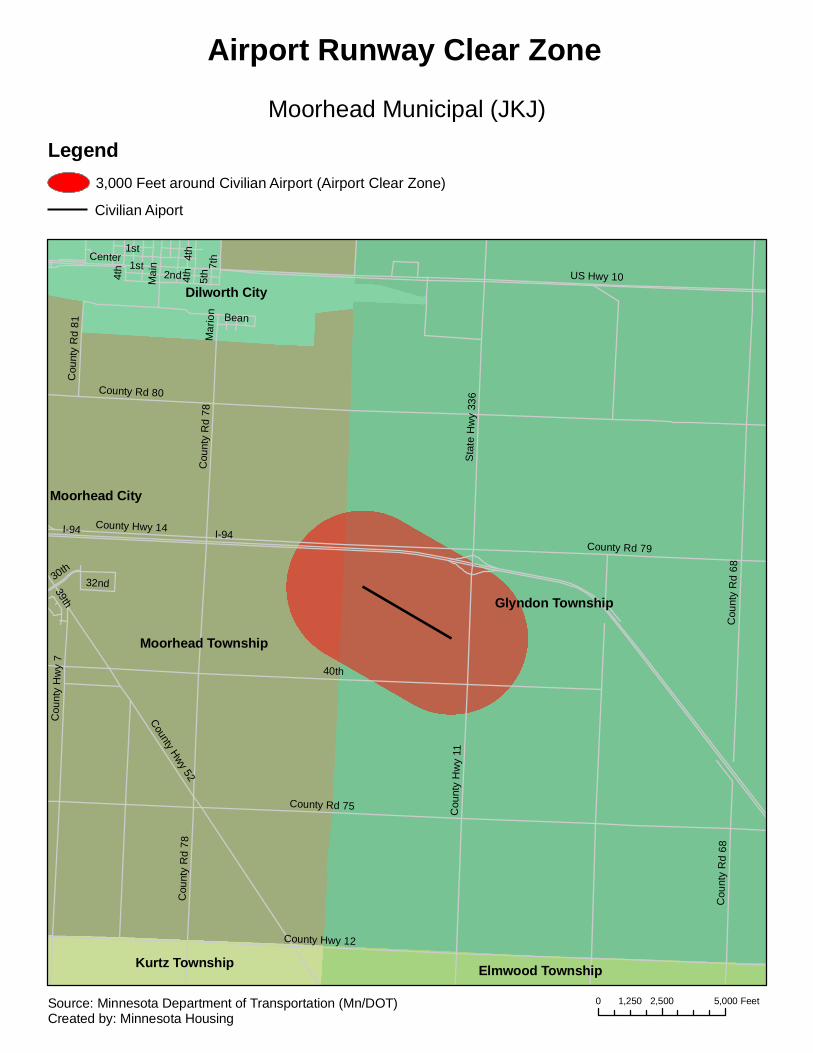
Glyndon Township
Moorhead Township
Dilworth City
Moorhead City
Kurtz Township Elmwood Township
I-94
40th
County Hwy 12
County Rd 75
Cou
nty
Rd
68
County Hwy 52
US Hwy 10
1st
County Hwy 14
Cou
nty
Hw
y 11
Cou
nty
Hw
y 7
2nd
County Rd 79
Sta
te H
wy
336
Center
Cou
nty
Rd
787t
h
Mai
n
County Rd 80
4th
5th
Cou
nty
Rd
81
30th
Bean
32nd39th
Mar
ion
Cou
nty
Rd
78
4th
I-94
Cou
nty
Rd
68
1st
4th
Moorhead Municipal (JKJ)
Airport Runway Clear Zone
Legend3,000 Feet around Civilian Airport (Airport Clear Zone)
Civilian Aiport
0 2,500 5,0001,250 FeetSource: Minnesota Department of Transportation (Mn/DOT)Created by: Minnesota Housing
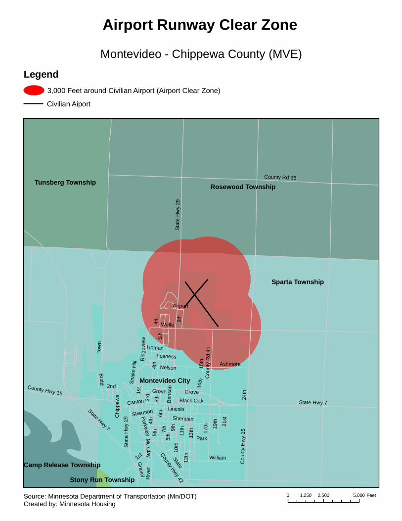
Sparta Township
Rosewood Township
Montevideo City
Tunsberg Township
Camp Release TownshipStony Run Township
6th
11th7th
State Hwy 7
3rd
Tow
n
12th
Sta
te H
wy
29
17th
County Rd 36
8th 13
th
Lincoln
1st State
Ben
son
5th
William
19thSheridan
Park
Black Oak
9th
10th
Cou
nty
Rd
41
2nd
Cou
nty
Hw
y 15
16th
Canton 24th
Ashmore
4th
Gravel
Sherman
Parkway
Rid
gevi
ew
Grove
Wolfe
County Hwy 4221
st
Budd
Chi
ppew
a
Riv
er
Fosness
Nelson
Snak
e H
ill
15th
Mc C
lay
Homan
Airport
1st
4th
State Hwy 7
9th
4th
5th
5th
County Hwy 15
Sta
te H
wy
29
Grove
Montevideo - Chippewa County (MVE)
Airport Runway Clear Zone
Legend3,000 Feet around Civilian Airport (Airport Clear Zone)
Civilian Aiport
0 2,500 5,0001,250 FeetSource: Minnesota Department of Transportation (Mn/DOT)Created by: Minnesota Housing
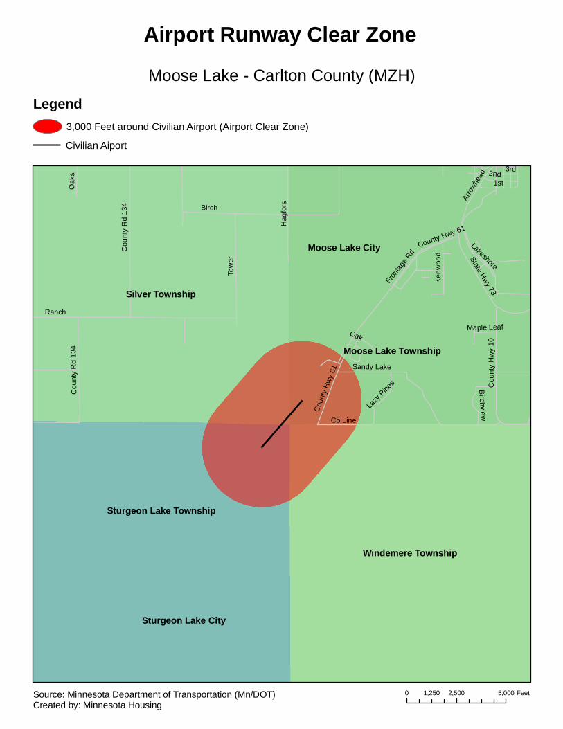
Silver Township
Windemere Township
Sturgeon Lake Township
Moose Lake Township
Sturgeon Lake City
Moose Lake CityTo
wer
Sandy Lake
Birch
1st
Hag
fors
Cou
nty
Hw
y 61
Cou
nty
Rd
134
Lakeshore
3rd
Arro
whea
d
State Hwy 73
Cou
nty
Hw
y 10
Ranch
Co Line
Oak
s
Ken
woo
d
2nd
Birchview
Lazy
Pine
sFr
ontag
e Rd
Maple LeafOak
County Hwy 61
Cou
nty
Rd
134
Moose Lake - Carlton County (MZH)
Airport Runway Clear Zone
Legend3,000 Feet around Civilian Airport (Airport Clear Zone)
Civilian Aiport
0 2,500 5,0001,250 FeetSource: Minnesota Department of Transportation (Mn/DOT)Created by: Minnesota Housing

Mora CityComfort Township
Arthur Township
Knife Lake Township Whited Township
220thM
ahog
any
Oly
mpi
c
Jopl
in
195th
Sta
te H
wy
65
Forest
State Hwy 23
9th
210th
Fair
Woo
d
Nig
hten
gale
Wal
nut
Osl
in
Howe
Gro
ve
Maple
Nap
les
7th
230th
Uni
on
200th
Par
k
Libe
rty
Bean
County Rd 69
Cla
rk
3rd4th
Mcl
ean
Burnett
Vine
Service
Pin
e R
idge
Elc
iff
Fran
kie
Keystone
Brook V
iew
228th
Collin
Brookview
1st
Central
2nd
Oak
Stewart
213th
Riverside
Villa
Sum
mit
6th
Pin
e
Locu
st
Gra
ce
Industrial Park
215th
210th
220th
Nap
les
State Hwy 23
Pine
Rid
ge
CentralMaple
Gro
ve
Libe
rty
2nd
Mora Municipal (JMR)
Airport Runway Clear Zone
Legend3,000 Feet around Civilian Airport (Airport Clear Zone)
Civilian Aiport
0 2,500 5,0001,250 FeetSource: Minnesota Department of Transportation (Mn/DOT)Created by: Minnesota Housing
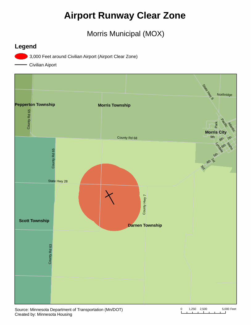
Darnen Township
Morris Township
Scott Township
Morris City
Pepperton Township
State Hwy 28
County Rd 68
6th
Cou
nty
Rd
63
Cou
nty
Hw
y 7
7th
Pacific
State Hwy 9
8th
4th
Idaho
9th
Northridge
Cou
nty
Rd
65
Atlantic
Par
k
Lyndale
5th
3rd
1st
Cou
nty
Rd
65
Morris Municipal (MOX)
Airport Runway Clear Zone
Legend3,000 Feet around Civilian Airport (Airport Clear Zone)
Civilian Aiport
0 2,500 5,0001,250 FeetSource: Minnesota Department of Transportation (Mn/DOT)Created by: Minnesota Housing
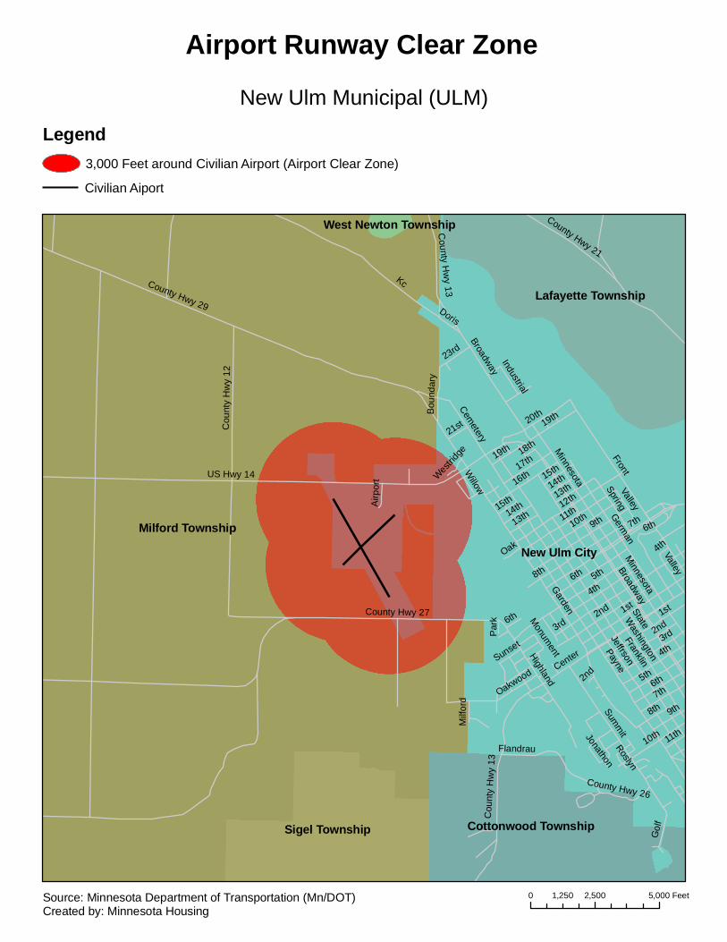
Milford TownshipNew Ulm City
Lafayette Township
Sigel Township Cottonwood Township
West Newton Township County Hwy 21
Kc
PayneState
Garden
3rd
5th
Franklin
Jeffrson
8th
US Hwy 14
9th
1stCounty Hwy 27 2nd
12th
County Hwy 29
7th11th
FrontGerm
an
4th
Cou
nty
Hw
y 12
Summ
it
20th
10th
16th
Broadway
Gol
f
HighlandM
innesota
17th
19th
Flandrau
Center
13th Spring
23rd
Valley
14th15th
Oakwood
Cemetery
County H
wy 13
Bou
ndar
y
6th
21st
Oak
Airp
ort
Sunset
Industrial
Jonathon
County Hwy 26
Willow
Milf
ord
Doris
Roslyn
18th
Par
k
Westrid
ge
Monum
ent
Washington
1st
6th
4th
Broadway
6th
3rd
14th
2nd
5th
Cou
nty
Hw
y 13
2nd
19th
8th
10th
Minnesota
15th
9th7th
11th
4th
13th
Valley
6th
New Ulm Municipal (ULM)
Airport Runway Clear Zone
Legend3,000 Feet around Civilian Airport (Airport Clear Zone)
Civilian Aiport
0 2,500 5,0001,250 FeetSource: Minnesota Department of Transportation (Mn/DOT)Created by: Minnesota Housing
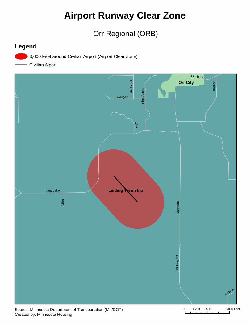
Leiding Township
Orr City
Nett Lake
John
son
Bra
ndt
Zika
US
Hw
y 53
Pin
e A
cres
Orr-buck
Olli
la
Sweigert
Hitc
hcoc
k
Janson
Orr Regional (ORB)
Airport Runway Clear Zone
Legend3,000 Feet around Civilian Airport (Airport Clear Zone)
Civilian Aiport
0 2,500 5,0001,250 FeetSource: Minnesota Department of Transportation (Mn/DOT)Created by: Minnesota Housing
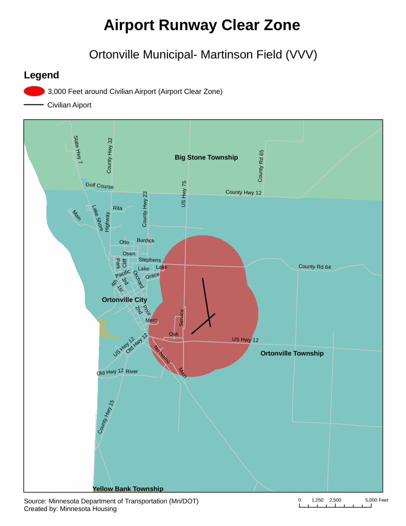
Ortonville Township
Ortonville City
Big Stone Township
Yellow Bank Township
US
Hw
y 75
1st
US Hwy 12
2ndCounty Rd 64
County Hwy 12
Lake Shore
3rd
Cou
nty
Hw
y 15
4th
Stephens
Main
Hig
hway
Otto
River
Cou
nty
Rd
65
Clif
f
Rita
Park
Osen
Oak
Cou
nty
Hw
y 32
No Name
State Hw
y 7
GraceO
rchard
Ser
vice
PacificLake
Golf Course
Old Hwy 12
Cou
nty
Hw
y 23
Mero
Burdick
Prior
US Hwy 1
2
Lake
Main
Old Hwy 1
2
Ortonville Municipal- Martinson Field (VVV)
Airport Runway Clear Zone
Legend3,000 Feet around Civilian Airport (Airport Clear Zone)
Civilian Aiport
0 2,500 5,0001,250 FeetSource: Minnesota Department of Transportation (Mn/DOT)Created by: Minnesota Housing
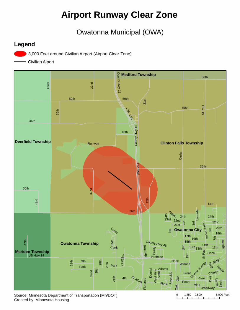
Clinton Falls Township
Owatonna City
Deerfield Township
Owatonna TownshipMeriden Township
Medford Township
I-35
26th
Ced
ar
46th
50thFrontage
36th
7th
St P
aul
ElmUS Hwy 14
Cou
nty
Hw
y 45
3rd
12th
56th
14th
Rose
Vine
32nd
North9th
42nd
Sta
te
30th
Pearl4th
47th
39th
16th
Oak
43rd
Park
Hoffman
Runway
40th
21st
Cherry
13th
County H
wy 22
Big
elow
Broadway
6th
Ridge
Lee
Front
18th
Riv
ersi
de
Flor
ence
1st
20th
24th
15th
Mineral
Spri
ngs
17th
23rd
28th
22nd
Hazel
Dar
t
Adams
Bra
dyD
unne
l
Birc
h
Winona
Leif
Flora
Larch
St Johns
25th
Greenw
ood
Maple
Lewis
Wes
t Hill
s
Ring
Clark
Arglen
Lam
ada
24th
26th
30th
Frontage
I-3550th
St P
aul
39th
22nd
32nd
13th
32nd
13th
21st
50th
Park
County Hwy 45
21st
24th
21st
4th
Oak
3rd
Owatonna Municipal (OWA)
Airport Runway Clear Zone
Legend3,000 Feet around Civilian Airport (Airport Clear Zone)
Civilian Aiport
0 2,500 5,0001,250 FeetSource: Minnesota Department of Transportation (Mn/DOT)Created by: Minnesota Housing

Park Rapids CityTodd Township
Straight River Township Hubbard Township
Henrietta Township
129t
h
1st
Park
150th
8th
139t
h
Mai
n
160th 30th
6th5th
Hen
rietta
4th
Mill
US
Hw
y 71
North
149t
h
2nd
Wes
tern
170th
152nd
State Hwy 34
Cen
tral
3rd
Fair
Eas
tern
County Hwy 14
12th
Gro
ve
River
Crocus Hill
Cou
nty
Hw
y 6
7thH
elte
nPineC
ourt
135t
h
Hollinger
Birch
Kaywood
Riv
ersi
de
High
Lake
King
Con
ifer
Todd
Albert
Hun
tsin
ger
Como
Fish Hook
Indu
stry
Dovetail
Mid
dle
Lawn
10th
Balsam
Com
mer
ce
Beach
3rd
8th
Mid
dle7th
Fair
North
State Hwy 34
6th
170th
Park Rapids Municipal - Konshok Field (PKD)
Airport Runway Clear Zone
Legend3,000 Feet around Civilian Airport (Airport Clear Zone)
Civilian Aiport
0 2,500 5,0001,250 FeetSource: Minnesota Department of Transportation (Mn/DOT)Created by: Minnesota Housing

Paynesville Municipal (PEX)
Airport Runway Clear Zone
MAP NOT AVAILABLE
PLEASE CALL MINNESOTA HOUSING
FOR INFORMATION
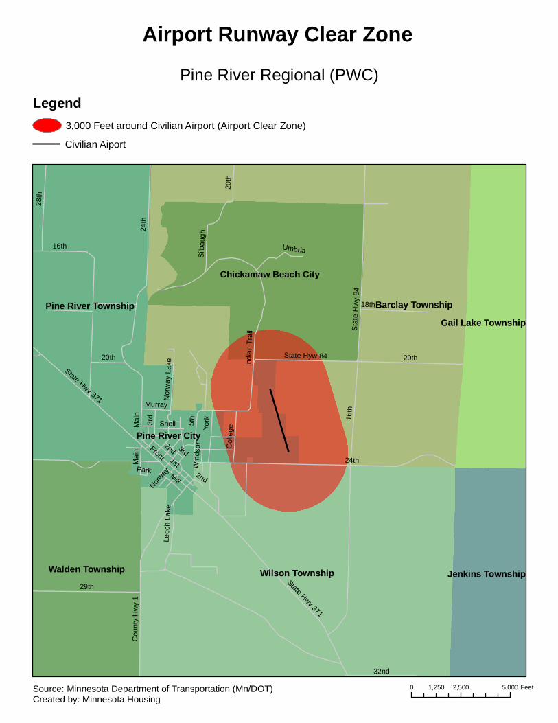
Wilson Township
Barclay TownshipPine River Township
Walden Township
Chickamaw Beach City
Pine River City
Gail Lake Township
Jenkins Township
16th
24th
29th
20th
1st
28th
Front
18th
Sta
te H
wy
84
32nd
State Hwy 371
Cou
nty
Hw
y 1
State Hyw 84
York5th
Indi
an T
rail
3rd
Silb
augh
Mill
Mai
n
Col
lege
Umbria
Leec
h La
ke
Snell
Nor
way
Lak
e
Murray
Norway 2nd
Park Win
dsor
State Hwy 371
Mai
n
16th
2nd 3rd24th
20th
20th
Pine River Regional (PWC)
Airport Runway Clear Zone
Legend3,000 Feet around Civilian Airport (Airport Clear Zone)
Civilian Aiport
0 2,500 5,0001,250 FeetSource: Minnesota Department of Transportation (Mn/DOT)Created by: Minnesota Housing

Gray Township
Sweet Township
Pipestone City
Unknown or No Streetname
Unk
now
n or
No
Stre
etna
me
Unk
now
n or
No
Stre
etna
me
8th
7th
4th
County Hwy 4
US Hwy 75
Main
Stat
e Hw
y 23
2nd
County Rd 67
Cou
nty
Hw
y 15
State Hwy 30
9th
3rd
Cou
nty
Rd
56
Hia
wat
ha
Cou
nty
Rd
57
5th
11th
10th
County Rd 55
13th
Sioux
6th
Cou
nty
Hw
y 30
Cou
nty
Rd
69
County Rd 61
Elb
on
Eas
t
Industrial
Pawnee
12th
5th
County Rd 56
5th
6th
9th
10th
4th
4th
7th
6th
County Rd 67
5th
7th
6th
3rd
Cou
nty
Rd
69
7th
8th
US
Hw
y 75
2nd
6th
7th
2nd
7th State Hwy 23County Hwy 15
8th
9th
9th
10th
State Hwy 30
9th
4th
Pipestone Municipal (PQN)
Airport Runway Clear Zone
Legend3,000 Feet around Civilian Airport (Airport Clear Zone)
Civilian Aiport
0 2,500 5,0001,250 FeetSource: Minnesota Department of Transportation (Mn/DOT)Created by: Minnesota Housing
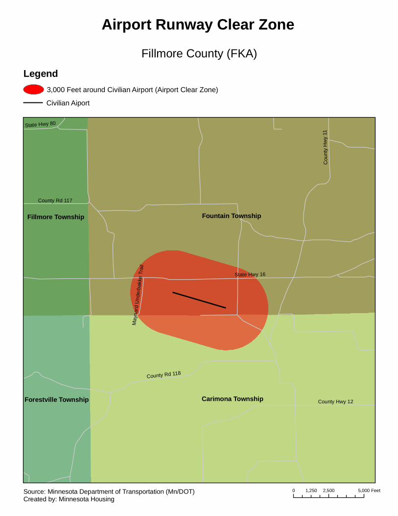
Fountain Township
Carimona Township
Fillmore Township
Forestville Township
State Hwy 16
Cou
nty
Hw
y 11
County Rd 117
County Rd 118
County Hwy 12
State Hwy 80
May
nard
Und
erba
kke
Trai
l
Fillmore County (FKA)
Airport Runway Clear Zone
Legend3,000 Feet around Civilian Airport (Airport Clear Zone)
Civilian Aiport
0 2,500 5,0001,250 FeetSource: Minnesota Department of Transportation (Mn/DOT)Created by: Minnesota Housing
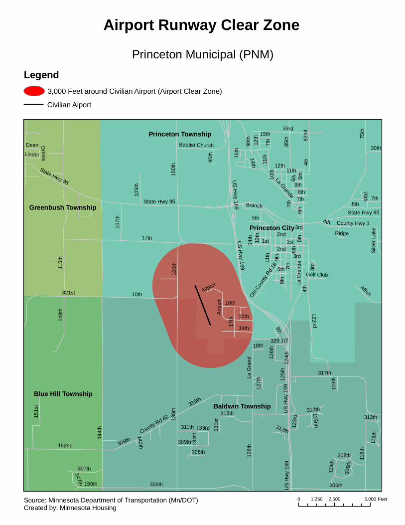
Baldwin Township
Princeton Township
Princeton City
Blue Hill Township
Greenbush Township
17th
115t
h
75th
7th
100t
h
8th
10th
33rd
9th
12th
3rd
US H
wy 169
2nd1st
6th
11th
13th
Branch
4th
85th
107t
h
82nd
5th
105t
h
Afton
90th
State Hwy 95
La G
rand
e
County Hwy 1
95th
30thBaptist Church
Airport
15th
Old Cou
nty R
d 18
Dean14th
Linder
Ridge
Silv
er L
ake
76th
Golf Club
Drew
s 16th
5th
100t
h
La Grande
14th
7th
9th
10th
3rd
1st
7th
12th
11th
5th
7th
5th
State Hwy 95
US H
wy 169
6th
11th
8th
4th
State Hwy 95
7th
3rd
4th
2nd
6th
5th
144t
h
136t
h
305th
124t
h
128t
h
321st
317th
116t
h
US
Hw
y 16
912
5th
315th
152nd
122nd
La G
rand
148t
h
151s
t
17th
14th
12th
309th
307th
312th
119t
h
10th
150th
115t
h
306t
h
311thCounty Rd 42
308th
123r
d
147th
Airp
ort
126t
h
131s
t
18th
9th
134t
h
313th
133rd
127t
h
320 1/2
140th
308th
US
Hw
y 16
9
312th
312th
122nd
305th
119t
h
309th
Princeton Municipal (PNM)
Airport Runway Clear Zone
Legend3,000 Feet around Civilian Airport (Airport Clear Zone)
Civilian Aiport
0 2,500 5,0001,250 FeetSource: Minnesota Department of Transportation (Mn/DOT)Created by: Minnesota Housing
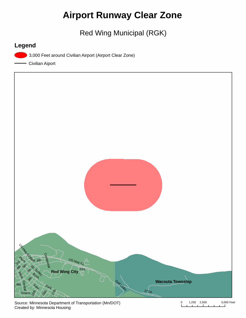
Red Wing City
Wacouta Township
7th Bush
5th
6th
4th
EastPark
US Hwy 61
Plum
9th
Bluff
271st
12th
3rd
West
15thGrace
Central
Golf Links
17th
US Hwy 63
ElmMc Sorley
Centennial
9th
Red Wing Municipal (RGK)
Airport Runway Clear Zone
Legend3,000 Feet around Civilian Airport (Airport Clear Zone)
Civilian Aiport
0 2,500 5,0001,250 FeetSource: Minnesota Department of Transportation (Mn/DOT)Created by: Minnesota Housing
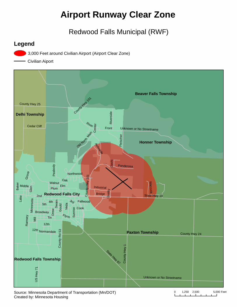
Paxton Township
Redwood Falls City
Beaver Falls Township
Honner Township
Delhi Township
Redwood Falls Township
Bridge
Mill
Sw
ain
2nd
5th4th
County Hwy 24
State Hwy 19
Tin
Elm
Cook
Cou
nty
Rd
53
State Hwy 67
Broadway
FrontC
ount
y H
wy
1Cedar Cliff
Flynn
County Hwy 25
Gro
ve
Sun
rise
Dre
w
Cou
nty
Hw
y 10
1
Plum
US
Hw
y 71
Normandale
Ponderosa
Veda
River
Flei
sche
r
Ram
sey
WalnutMiddle
Unknown or No Streetname
Pea
body
Industrial
Northwood
Riv
ersi
de
Min
neso
ta
12th
Fallwood
Wacouta
Main
Lake
Gou
ld
Old Nort
h
3rd
Oak
Activaide
Dav
isQ
ualit
yGle
n
Bak
er
Cen
ter
12th
Unknown or No Streetname
County
Hwy 1
01
Redwood Falls Municipal (RWF)
Airport Runway Clear Zone
Legend3,000 Feet around Civilian Airport (Airport Clear Zone)
Civilian Aiport
0 2,500 5,0001,250 FeetSource: Minnesota Department of Transportation (Mn/DOT)Created by: Minnesota Housing

High Forest Township
Rochester City
Rochester Township
Rock Dell Township
Marion TownshipSalem Township
Stewartville City
Sumner Township
Pleasant Grove Township
I-90
60th
40th
11th
48th
105th
Cou
nty
Hw
y 8
31st
80th
Cou
nty
Hw
y 1
15th
50th
Cou
nty
Hw
y 15
State Hwy 30
45th
6th
98th
3rd
1st
County Hwy 6
Cou
nty
Hw
y 20
110th
5th
US Hwy 52
87th
100th
95th
120th
75th
18th
St B
ridge
ts
55th
2nd
10th
US
Hw
y 63
52nd
37th
36th
65th
20th
30th
85th
Cou
nty
Rd
115
Bamber Valley
County Rd 108
38th
Bro
adw
ay
9th
70th
County Rd 120
42nd
County Hwy 16
4th
23rd
90th
County Hwy 35
Mai
n
L.c.
12th
Ente
rpris
e
Lillie
7th
22nd
Willow
8th
Scenic Oak
Woodbine
Greystone
35th
Lone Pine
Senario
Tower
55th
50th
I-90
55th
3rd
6th
State Hwy 3011th
60th
40th
11th
37th
37th
31st
110th
105th
23rd
36th
80th20
th
US
Hw
y 63
6th
County Hwy 16
6th
US Hwy 52
20th
75th
60th
70th
80th
3rd
20th
31st
Rochester International (RST)
Airport Runway Clear Zone
Legend3,000 Feet around Civilian Airport (Airport Clear Zone)
Civilian Aiport
0 5,000 10,0002,500 FeetSource: Minnesota Department of Transportation (Mn/DOT)Created by: Minnesota Housing
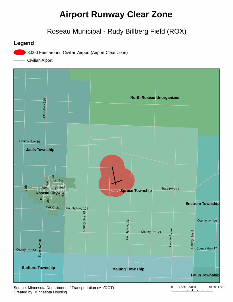
Spruce Township
Jadis Township
North Roseau Unorganized
Malung Township
Roseau City
Stafford Township
Enstrom Township
Falun Township
State Hwy 11
Cou
nty
Hw
y 28
Sta
te H
wy
310
County Rd 124
Cou
nty
Hw
y 9
Center
Cou
nty
Rd
129
11th
Cou
nty
Hw
y 31
Sta
te H
wy
89
9th
3rd
Mai
n
7th
6th
5th
County Hwy 16
County Rd 114 County Hwy 12
County Hwy 124
2nd
Oak Crest
15th
5th
2nd
County Rd 124
Roseau Municipal - Rudy Billberg Field (ROX)
Airport Runway Clear Zone
Legend3,000 Feet around Civilian Airport (Airport Clear Zone)
Civilian Aiport
0 5,000 10,0002,500 FeetSource: Minnesota Department of Transportation (Mn/DOT)Created by: Minnesota Housing
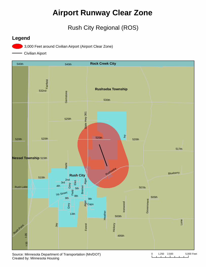
Rushseba Township
Rush City
Rock Creek City
Nessel Township
I-35
530th
540th
4th
500th
Fairf
ield
Gov
ernm
ent
Jay
8th
525th
517th
Fiel
d
Har
te
Sta
te H
wy
361
Bre
mer
2nd
5th
Fore
st
BlueberryRushseba
507th
Rush P
oint
3rd
Ivy
Hea
ther
520th
Gre
y
Elio
t
Alg
er
Hic
kory
510th
Ironw
ood
9th
532nd
495th
Rush Lake
515th
505th
Lone
Caps
Gem
ston
e
13th
7th Street
520th
Alg
er
I-35
Gre
y
520th 520th
540th
9th
Rush City Regional (ROS)
Airport Runway Clear Zone
Legend3,000 Feet around Civilian Airport (Airport Clear Zone)
Civilian Aiport
0 2,500 5,0001,250 FeetSource: Minnesota Department of Transportation (Mn/DOT)Created by: Minnesota Housing
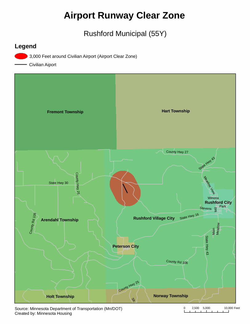
Rushford Village CityArendahl Township
Hart TownshipFremont Township
Norway TownshipHolt Township
Rushford City
Peterson City
State Hwy 30
State Hwy 16
County H
wy 25
Mill
State H
wy 43
Sfr
Cou
nty
Rd
105
County Rd 106
County Hwy 27
ParkStevens
Winona
Meadow View
Mai
nM
eado
w
State Hwy 43
County Hwy 25
Rushford Municipal (55Y)
Airport Runway Clear Zone
Legend3,000 Feet around Civilian Airport (Airport Clear Zone)
Civilian Aiport
0 5,000 10,0002,500 FeetSource: Minnesota Department of Transportation (Mn/DOT)Created by: Minnesota Housing

Sauk Centre Township
Sauk Centre City
Getty Township
Melrose Township
Grove Township
I-94
375t
h
US
Hw
y 71
385th
Mai
n
395th
County R
d 186A
sh
2nd
4th
6th
12th
5th
Get
ty
Cou
nty
Rd
187 County Hwy 29
1st
Pin
e
420th
Min
nette
County R
d 185
Mccormic LakeState Hwy 28
Cen
tre
Sinclair Lewis
393rd
Oak
Elm
373r
d
State
355t
h
ParkM
aple
Eas
t
County Hwy 17
9th
10th
View
County Rd 188
415thCounty Rd 125
Plea
sant
Ale
x M
oore
9 1/2
Will
ow
Min
ette
I-94
10th
1st
393r
d
385th
2nd
385t
h
395t
h
Sauk Centre Municipal (D39)
Airport Runway Clear Zone
Legend3,000 Feet around Civilian Airport (Airport Clear Zone)
Civilian Aiport
0 2,500 5,0001,250 FeetSource: Minnesota Department of Transportation (Mn/DOT)Created by: Minnesota Housing
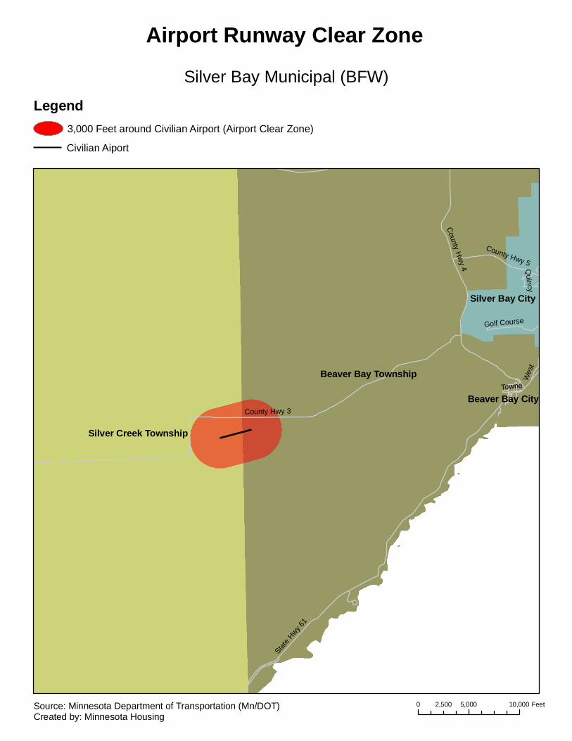
Silver Creek Township
Beaver Bay Township
Silver Bay City
Beaver Bay CityCounty Hwy 3
State H
wy 61
County H
wy 4
County Hwy 5
Golf Course
Towne
Quincy
Wes
t
Silver Bay Municipal (BFW)
Airport Runway Clear Zone
Legend3,000 Feet around Civilian Airport (Airport Clear Zone)
Civilian Aiport
0 5,000 10,0002,500 FeetSource: Minnesota Department of Transportation (Mn/DOT)Created by: Minnesota Housing
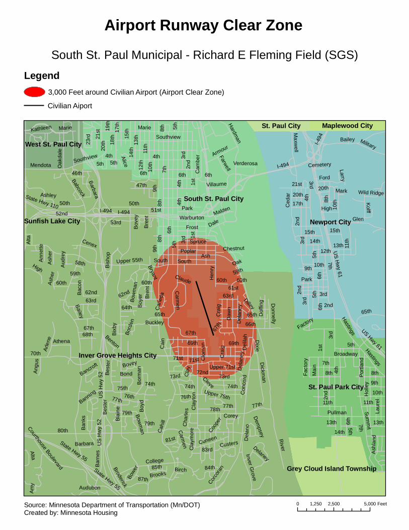
Inver Grove Heights City
Newport City
South St. Paul City
St. Paul Park City
West St. Paul City
St. Paul City Maplewood City
Grey Cloud Island Township
Sunfish Lake City
80th
I-494
5th
Con
cord
Cah
ill
Babcock
US
Hw
y 52
9th
River
8th
65th
7th
1st
75th
78th
4th
70th
2nd
50th
Daw
n
6th
11th
66th
72nd
Bla
ine
Upper 55th
12th
13th
10th
Poplar
3rd
College
Cla
yton
Hardman
18th
69th
Ash
Marie14
th
Spruce
Bar
nes
74th
77th
63rd
Dickm
an
Cuneen
State Hwy 55
South
Carm
en
52ndH
enry
Barbara
15th
21st
47th
Broderick
Oak
dale
Frost
Arle
ne
87th
High
Armour
Dof
fing
Inver Grove
Corey
71st
17th
Courthouse Boulevard
MendotaSouthview
Park
Brooks
Alta
79th
Bor
manBe
ster
73rd
76th
Villaume
68th
Coope
r
64th
23rd
Cenex
Boy
d
85th
67thAthena
Cam
ber
60thClaude
51st
Donnelly
62nd
81st
46th
Kathleen
Ashe
r
Boy
er
Bond
Farwell
State Hwy 110
Birch
Bowe
r
Dixie
Angu
s
Warburton
20th
Cla
ymor
e
Bis
hop
Bac
on
Bryant
Ban
ks
Dale
Cleve
Bowm
an
Delaney
Corco
ran
Upper 71stBovey
Bailey
Audubon
19th
Cla
y
53rd
84th
Ann
ette
Cai
nVerderosa
83rd
Malden
Custers
Alice
Cra
ig
Ashley
Bre
nt
Bix
by
Chestnut
Bancroft
Cha
rles
DilleyCar
leda
58th
59th
Del
ilah
Buckley
Benton
Aud
rey
Clo
man
Upper 75th
Oak
Am
y
Dem
psey
Del
ano
Banning
61st
Bord
en
60th60th
79th
67th
5th
South
59th
Bow
man
Del
aney
5th
60th
62nd 63rd
74th
6th
4th
3rd
Bov
ey
65th
50th
5th8t
h
77th
Del
aney
Barbara
4th
Carm
en
Ash
er
Bes
ter
77th
6th
8th
Cra
igI-494
69th
76th
US
Hw
y 52
State Hwy 55
67th
4th
Bre
nt
1st
74th
71st
Alta
9th
73rd
6th
Marie
Southview
4th
7th
1st
9th
2nd
US Hwy 61
10th
I-494
12th
Summ
it
Glen
Mai
n
3rd
Bailey
8th
5th
Ced
ar
21st
Pullman
Hol
ley
11th
Por
tland
Maxw
ell
6th
65th
Broadway
Ford
Kolff
Ash
land
Military
13th14th
High
Hastings
15th
Park
Fact
ory
20th
Laur
el
17th
Wild Ridge
Larry
Mark
Cemetery
4th
6th
5th
3rd
9th
13th
14th
US H
wy 61
6th
3rd
2nd
8th
Factory
2nd
3rd
Hastings
3rd
11th
7th
7th
15th
20th
11th
5th
13th
10th
2nd
I-494
5th
10th
8th
South St. Paul Municipal - Richard E Fleming Field (SGS)
Airport Runway Clear Zone
Legend3,000 Feet around Civilian Airport (Airport Clear Zone)
Civilian Aiport
0 2,500 5,0001,250 FeetSource: Minnesota Department of Transportation (Mn/DOT)Created by: Minnesota Housing
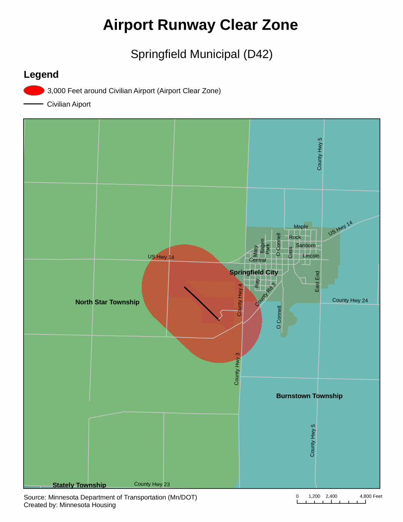
North Star Township
Burnstown Township
Springfield City
Stately Township
US Hwy 14
RockC
ount
y H
wy
4
Cou
nty
Hw
y 5
Par
k
Cas
s
Cou
nty
Hw
y 3
Lincoln
County Hwy 23
Central
O C
onne
ll
Sanborn
Eas
t End
Ray
Maple
County
Rd 3
Bag
en
County Hwy 24
Mar
y
Cou
nty
Hw
y 5
US Hwy 14
O C
onne
ll
Springfield Municipal (D42)
Airport Runway Clear Zone
Legend3,000 Feet around Civilian Airport (Airport Clear Zone)
Civilian Aiport
0 2,400 4,8001,200 FeetSource: Minnesota Department of Transportation (Mn/DOT)Created by: Minnesota Housing

Haven Township
Minden Township
Palmer Township
St. George Township
St. Cloud City
St. Augusta City
Sauk Rapids City
Sauk Rapids Township
2nd
15th
75th35th
30th
95th
3rd65
th
25th
55th
Duelm
State Hwy 95
10th Shadowwood
5th
US Hwy 10
Mayhew Lake
42nd
Primrose
7th
Golden Spike
13th
State H
wy 23
LincolnWilson
45th
90th
Franklin
23rd
85th
Hwy 46
Industrial
92nd
24 1
/2
1st
16th
40th
6th
Woodland
28th
Foley
14th
35th
5th
5th
14th
10th
3rd
7th
40th
25th
7th
75
17th
47th
57th
90
42nd
32nd
US Hwy 10 27th
65th
45th
117th
12th
54th
9th
95
60th
35th
8th
95th
7th
16th
15th
37th
Kili
an
50th49th
County H
wy 8
52nd
Michigan
10thLincoln
County Rd 66
40th
20th
31st
38th
36th
55th
Coun
ty Hw
y 6
11th
64th
63rd
13th
61st
14 1/2
14th
42nd
42nd
90
45th
US Hwy 10
57th
45th
65th
54th
15th
95
60th
50th
St. Cloud Regional (STC)
Airport Runway Clear Zone
Legend3,000 Feet around Civilian Airport (Airport Clear Zone)
Civilian Aiport
0 5,000 10,0002,500 FeetSource: Minnesota Department of Transportation (Mn/DOT)Created by: Minnesota Housing

Rosendale Township
Riverdale Township
St. James Township
South Branch Township
Nelson Township
St. James City
Antrim Township
Fieldon Township
Madelia Township
Long Lake Township
Cou
nty
Hw
y 16
Cou
nty
Rd
109
State Hwy 60
County Hwy 13
County Rd 116
1st
Sta
te H
wy
4
Cou
nty
Hw
y 12
Cou
nty
Hw
y 27
11th
Cou
nty
Rd
103
Cou
nty
Rd
104
2nd
9th
8th
County Hwy 3
Wes
t
3rd
7th
4th
County Rd 127
15th
County Rd 119
Cou
nty
Rd
118
County Hwy 10
5th
10th
12th
Willow
Cou
nty
Hw
y 27
10th
County Rd 116
State Hwy 604th
Cou
nty
Hw
y 13
11th
3rd
St. James Municipal (JYG)
Airport Runway Clear Zone
Legend3,000 Feet around Civilian Airport (Airport Clear Zone)
Civilian Aiport
0 5,000 10,0002,500 FeetSource: Minnesota Department of Transportation (Mn/DOT)Created by: Minnesota Housing
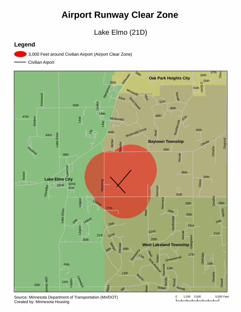
Lake Elmo City
Baytown Township
West Lakeland Township
Oak Park Heights City
10th
30th
40th
50th
58th
Man
ning
Oak
gree
n
Nea
l
Osg
ood
20th
Lake
Elm
o
53rd
Nol
an
51st
57th
Olinda
47th
43rd
39th
34th
Orw
ell
12th
24th
Mcdonald
Oriole
32nd
Kim
bro
36thN
orel
l
Stillw
ater
26th
22nd
27th
49th
Nor
thbr
ook
Newbe
rry
Oas
is
Om
aha
21st
Mcf
air
18th
55th
Kel
vin
Nor
dic
Lave
rne
Morris
O Brien
15th
Legi
on Nor
thrid
ge
48th
Leaf
Nor
cres
t
Men
del
28th
Kirk
woo
d
13th
44th
Nov
ak
31st
Greenwood
54th
14th
Lind
enM
uir
45th
Lily
Nor
man
9th
Layt
on56th
23rd
17th
Old
ridge
Lisbon
Mar
k
Margo
Klon
dike
Kindred
Leeward
Mar
ques
s
Monarda
53rd StreetLi
lac
Ore
n
Mcdonald Drive
11th
Neal Avenue
10th Street N
eal
Nor
cres
t
Lake
Elm
o
22nd
Legi
on
Men
del
28th
Lilac
Nolan Novak
Neal17th
26th
47th
Om
aha
Nea
l
24th
21st
18th
Om
aha
24th
55th
32nd
Novak
20th Nov
ak
Lisbon
Lake Elmo (21D)
Airport Runway Clear Zone
Legend3,000 Feet around Civilian Airport (Airport Clear Zone)
Civilian Aiport
0 2,500 5,0001,250 FeetSource: Minnesota Department of Transportation (Mn/DOT)Created by: Minnesota Housing
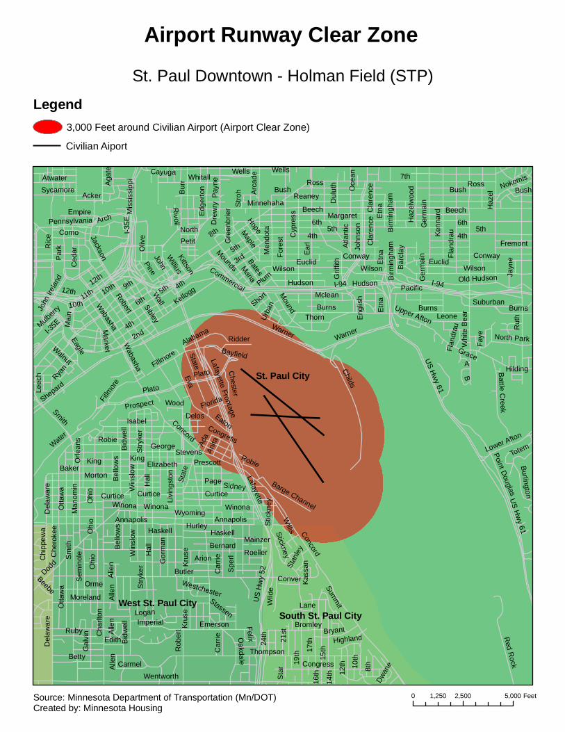
St. Paul City
West St. Paul CitySouth St. Paul City
Butler
Thompson
Wentworth
Sm
ith
Hal
l
Emerson
19th
Dodd
Rob
ert
Bernard
Concord
Cha
rlton
Ohi
o
Del
awar
e
Moreland
17th
15th
Annapolis
Otta
wa S
tryke
r
US
Hw
y 52
Congress
Bid
wel
l
Che
roke
e
Haskell
10thBetty
12th
Ruby
21st
Arion
Spe
rl
Hurley
Bromley
Stickney
Bryant
Sem
inol
e
14th
Alle
n Summ
it
8th
Gor
man
Wild
e
Chi
ppew
a
24th
Dwan
e
Stan
ley
Oakdale
Imperial
Orme
Win
slow
Kru
se
Car
rie
Logan
Carmel
16th
Gal
vin
Edith
Mainzer
Bel
low
s
Felix
Stassen
ConverBeebe
Willis
Curtice
Highland
Winona
Roeller
Sta
r
Lane
Kas
san
Westchester
Kru
se
Alle
n
Ohi
o
Haskell
Alle
nA
llen
Car
rie
Wabasha
7th
I-94
3rd
6th
Rut
h
Robert
Ear
l
Margaret
Minnehaha
5th
US H
wy 61
Warner
I-35E
Hal
l Lafayette
Ric
e
Ohi
o
Plato
Kellogg
Childs
Haz
el
Wilson
Whi
te B
ear
Concord
12th
Mounds
Fore
st9th
George
Shepard
Euclid
John
son
Stry
ker
Mclean
King
Ken
nard
Baker
State
4th
Bush
Robie
Win
slow
Ross
Eva
BurnsUpper Afton
Pay
ne
Bid
wel
l
Cyp
ress
Point Douglas
Old Hudson
Atla
ntic
Page
Isabel
Bates
Ger
mai
n
Maria
Water
B
Wyoming
Otta
wa
Bur
r
2nd
Curtice
Morton
Man
omin
Wabasha
11th
Whitall
Red R
ock
Men
dotaComo
Acker
Par
k
Mis
siss
ippi
Arc
ade
Eaton
Beech
Dul
uth
Suburban
Wall
JacksonStevens
Congress
Oliv
e
Pacific
Winona
Livi
ngst
on
Conway
10th
Annapolis
Battle C
reek
Sibley
MapleLeone
Delos
Arch
Sycamore
Mound
Hudson
Orle
ans
Bel
low
s
Ced
ar
Pennsylvania
Eagle
Burlington
Edg
erto
n
Wells
Fillm
ore
Smith
Atwater
Haz
elw
ood
Pine
Thorn
Del
awar
e
Hope
Alabama
A
Nokomis
Lower Afton
8th
Lafayette Frontage
Ada
North ParkRidder
Aga
te
Chester
Fremont
Cayuga
John
Irel
and
Etn
a
Empire
Barge Channel
TotemAnita
Mai
n
Reaney
Walnut
Faye
Short
Prescott
NorthPetit
Rivoli
Stic
kney
Market
Elizabeth
Leec
h
WoodW
illius
Plum
Prospect
Jayn
e
Urba
n
John Commercial
Sidney
Kittson
Flan
drau
Ryan
Grace
Cla
renc
e
Florida
Gre
enbr
ier
Birm
ingh
am
Hilding
Oce
an
Mulberry
Eng
lish
Stro
h
Dre
wry
Bayfield
Grif
fith
Bar
clay
Burns
4th
Hudson
Burns
5th
I-94
Fillmore
Robie
Flan
drau
Euclid
Etn
a
Wilson
6th
6th
King
US H
wy 61
Plato
Wilson
Cla
renc
e
Beech
Winona
BushBush
Birm
ingh
am
Warner
Curtice
I-35E
10th
Ger
mai
n
Stat
e
Wells
12th
Etn
a
5th
4th 4th
Conway
Ross
5th
St. Paul Downtown - Holman Field (STP)
Airport Runway Clear Zone
Legend3,000 Feet around Civilian Airport (Airport Clear Zone)
Civilian Aiport
0 2,500 5,0001,250 FeetSource: Minnesota Department of Transportation (Mn/DOT)Created by: Minnesota Housing
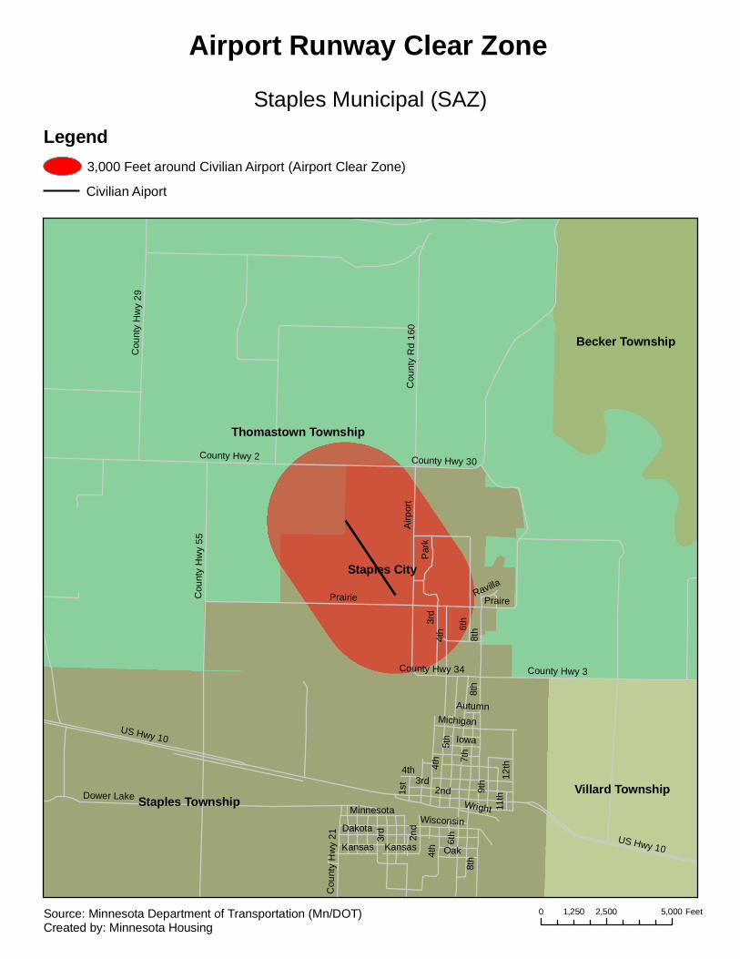
Thomastown Township
Staples Township
Staples City
Villard Township
Becker Township
6th
7th
5th
4th
Dower Lake
3rd
8th
Dakota
9th 12
th
US Hwy 10
Wisconsin
2nd
Oak
Michigan
Iowa
1st
WrightMinnesota
Cou
nty
Hw
y 21
Kansas
11th
County Hwy 34
Autumn
8th
Kansas
2nd3rd
US Hwy 10
4th
4th
Prairie
Airp
ort
8th
County Hwy 2
4th
3rd
County Hwy 30
Cou
nty
Hw
y 29
Cou
nty
Rd
160
County Hwy 3
Cou
nty
Hw
y 55
Par
k
6th
PraireRavilla
Staples Municipal (SAZ)
Airport Runway Clear Zone
Legend3,000 Feet around Civilian Airport (Airport Clear Zone)
Civilian Aiport
0 2,500 5,0001,250 FeetSource: Minnesota Department of Transportation (Mn/DOT)Created by: Minnesota Housing
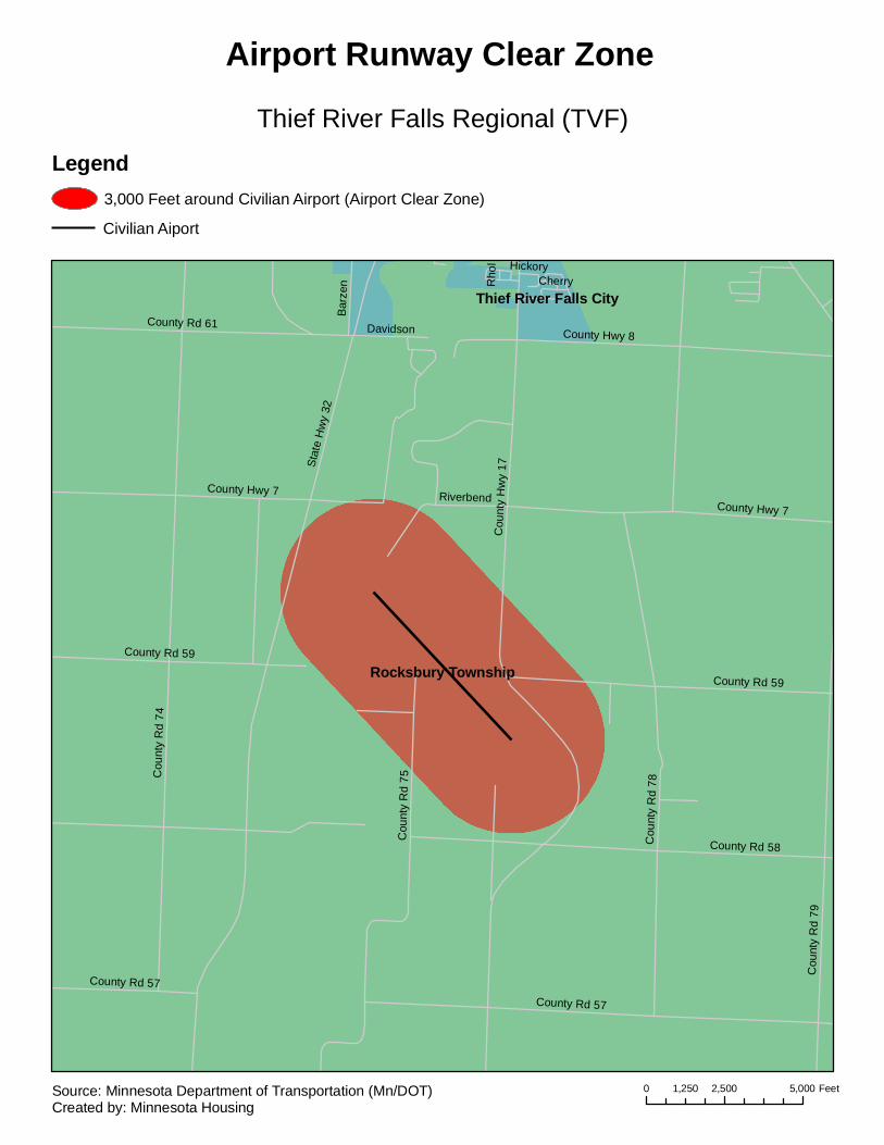
Rocksbury Township
Thief River Falls CitySt
ate
Hw
y 32
Cou
nty
Rd
74
Cou
nty
Hw
y 17
County Rd 58
Cou
nty
Rd
75
County Rd 57
County Rd 59
County Hwy 7
County Hwy 8County Rd 61
Cou
nty
Rd
79
Cou
nty
Rd
78
Bar
zen
Riverbend
Davidson
HickoryCherryR
hol
County Rd 59
County Rd 57
County Hwy 7
Thief River Falls Regional (TVF)
Airport Runway Clear Zone
Legend3,000 Feet around Civilian Airport (Airport Clear Zone)
Civilian Aiport
0 2,500 5,0001,250 FeetSource: Minnesota Department of Transportation (Mn/DOT)Created by: Minnesota Housing
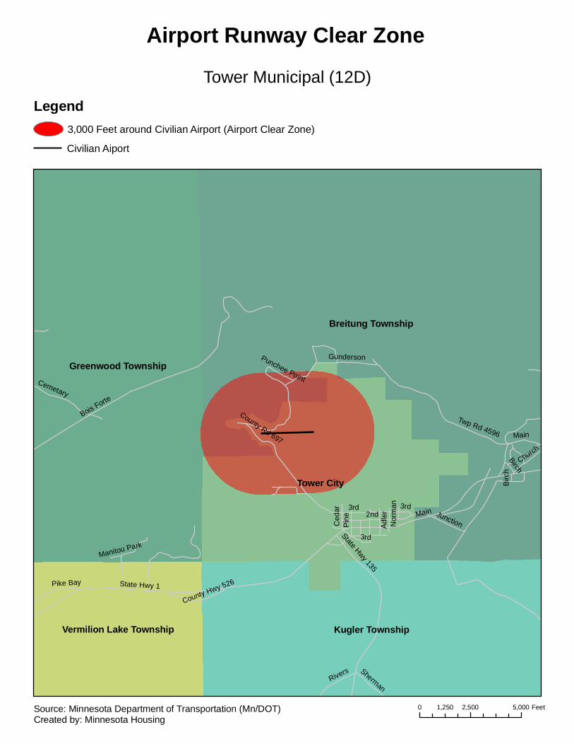
Breitung Township
Tower City
Greenwood Township
Kugler TownshipVermilion Lake Township
Main
Bois Forte
State Hwy 1
2nd
Gunderson
Twp Rd 4596
State Hwy 135
Junction
County Rd 697
3rd
Cemetary
Rivers
Ced
ar
Pike Bay
ChurchBirch
Adl
er
Pin
e
Sherman
County Hwy 526
Manitou Park
Punchee Point
Nor
man
Main
3rd
3rdB
irch
Tower Municipal (12D)
Airport Runway Clear Zone
Legend3,000 Feet around Civilian Airport (Airport Clear Zone)
Civilian Aiport
0 2,500 5,0001,250 FeetSource: Minnesota Department of Transportation (Mn/DOT)Created by: Minnesota Housing
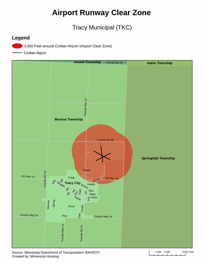
Monroe Township
Springdale Township
Tracy City
Gales TownshipAmiret Township4t
h
Cou
nty
Rd
73
Craig
Pine
Cou
nty
Hw
y 11
South
3rd
1st
Morgan
Cen
terFront
Hollett
8th
Elm
Emory
US Hwy 14
County Rd 56
County Rd 79
State
2nd
County Hwy 14
Union
10th
Par
k
Spr
ing
5th
Oak
Mon
roe
Maple
Circle US Hwy 14
2nd
Cou
nty
Rd
73
Cou
nty
Hw
y 11
County Hwy 14
Tracy Municipal (TKC)
Airport Runway Clear Zone
Legend3,000 Feet around Civilian Airport (Airport Clear Zone)
Civilian Aiport
0 2,500 5,0001,250 FeetSource: Minnesota Department of Transportation (Mn/DOT)Created by: Minnesota Housing
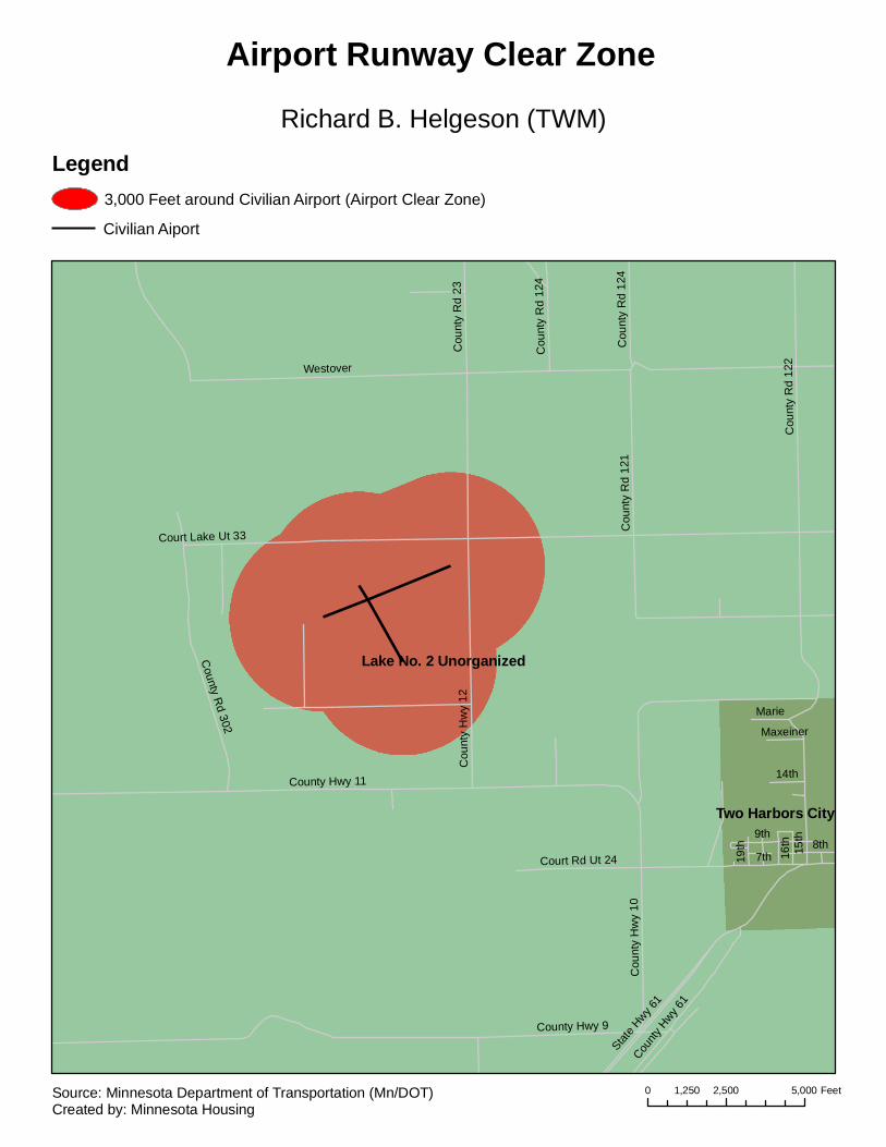
Lake No. 2 Unorganized
Two Harbors CityCounty Hwy 11
County Hwy 9
15th
Cou
nty
Rd
122
Westover
Cou
nty
Hw
y 12
7th
9th
Cou
nty
Rd
121
County R
d 302
8th
State H
wy 61
County
Hwy 6
1
Cou
nty
Hw
y 10
Court Rd Ut 24
Cou
nty
Rd
23
14th16
th
Cou
nty
Rd
124
Marie
19th
Maxeiner
Court Lake Ut 33C
ount
y R
d 12
4
Richard B. Helgeson (TWM)
Airport Runway Clear Zone
Legend3,000 Feet around Civilian Airport (Airport Clear Zone)
Civilian Aiport
0 2,500 5,0001,250 FeetSource: Minnesota Department of Transportation (Mn/DOT)Created by: Minnesota Housing

Wadena Township
Wadena City
Leaf River Township
Compton Township
Bluffton Township
Ash
2nd
County Hwy 4
US Hwy 7
1
US Hwy 10
Birch
Cou
nty
Hw
y 20
King
Cou
nty
Rd
169
9th
3rd
5th
Irving
11th
Bryant
Aldrich
Oin
k Jo
int
Dayton
1st
Elm
4th
Cou
nty
Rd
100
Alfred
Apa
che
Olmsted
Colfax
6th
Jefferso
n
Garfield10th
7th
Cou
nty
Rd
103
Loui
s
Cou
nty
Rd
101
Rei
ni
8th
Deerwood
Fir
Hom
ecre
st
Paula
Greenwood
130th
Indu
stria
l Carol
NixonMadisonLi
ncol
n
Park
Hickory
Franklin
Parkview 123r
d
Juniper
Sou
th B
rook
Ironwood
Hwy Service
4th
9th
US H
wy 71
Lincoln8th
1st
4th
Jeffe
rson
2nd
10th
2nd
9th
10th
3rd
4th
Alfred
1st
Fir
5th
1st
3rd
Wadena Municipal (ADC)
Airport Runway Clear Zone
Legend3,000 Feet around Civilian Airport (Airport Clear Zone)
Civilian Aiport
0 2,500 5,0001,250 FeetSource: Minnesota Department of Transportation (Mn/DOT)Created by: Minnesota Housing
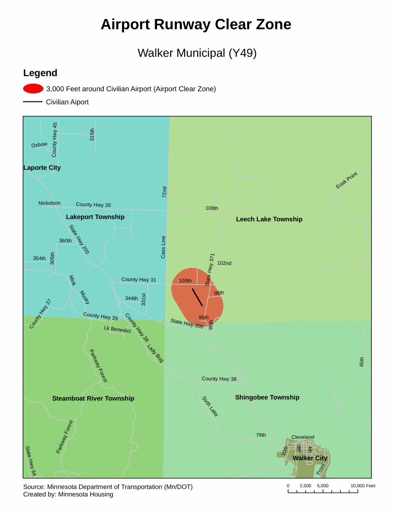
Leech Lake TownshipLakeport Township
Shingobee TownshipSteamboat River Township
Walker City
Laporte City72
nd
Stat
e H
wy
371
108th
100th
45th
Sixth Lake
8th
10th
Eoak Point
79th
98th
4th
County Hwy 38
95th
Fron
tState Hwy 200
102nd
Cleveland
95thState Hwy 200
Cas
s Li
ne
County Hwy 30
County Hwy 39
315t
h
Musky
331s
t
354th
305t
h
County Hwy 38
344th
Cou
nty
Hw
y 45
Parkway Forest
360th
County Hwy 31
Coun
ty Hw
y 37
Oxbow
State Hw
y 64
Mink
Lk Benedict
Nickolson
Lady Bug
Park
way
For
est
Walker Municipal (Y49)
Airport Runway Clear Zone
Legend3,000 Feet around Civilian Airport (Airport Clear Zone)
Civilian Aiport
0 5,000 10,0002,500 FeetSource: Minnesota Department of Transportation (Mn/DOT)Created by: Minnesota Housing

Lake Township
Angle Unorganized
Warroad City
State Hw
y 313
Taylor
Elk
State Hwy 11
Mai
n
Lake
Sta
te
County Rd 137
County Hwy 1
3C
edar
1stRob
erts
Gladys
Virg
inia
Hallberg
3rd
4th
MackenzieCounty Hwy 35
2nd
7th
Ple
asan
t
River
County Hwy 13
Warroad International - Swede Carlson Field (RRT)
Airport Runway Clear Zone
Legend3,000 Feet around Civilian Airport (Airport Clear Zone)
Civilian Aiport
0 2,500 5,0001,250 FeetSource: Minnesota Department of Transportation (Mn/DOT)Created by: Minnesota Housing
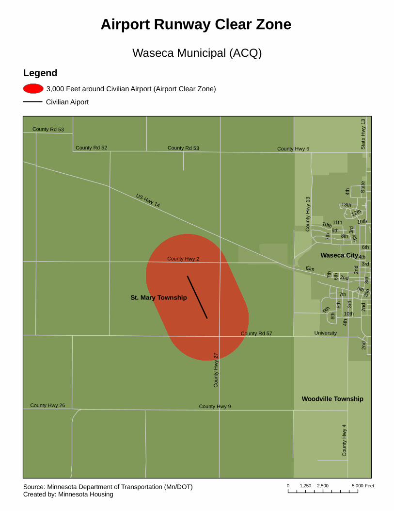
St. Mary Township
Waseca City
Woodville Township
Sta
te
US Hwy 14
Elm
2nd
County Hwy 9
County Hwy 2
Cou
nty
Hw
y 27
5th
8th9th
6th
County Hwy 5
Cou
nty
Hw
y 4
County Rd 57
4th
10th
3rd
County Rd 53
University7t
h
13th
Cou
nty
Hw
y 13
County Rd 52
12th
County Hwy 26
Sta
te H
wy
13
11th
6th
County Rd 53
10th
7th
7th
9th
6th
2nd
2nd
3rd
2nd
4th
4th
2nd
3rd
4th
6th
10th
3rd
Waseca Municipal (ACQ)
Airport Runway Clear Zone
Legend3,000 Feet around Civilian Airport (Airport Clear Zone)
Civilian Aiport
0 2,500 5,0001,250 FeetSource: Minnesota Department of Transportation (Mn/DOT)Created by: Minnesota Housing

Lake Valley Township
Walls Township
Wheaton City
Croke Township
State Hwy 27
Cou
nty
Hw
y 7
2nd3rd
11th
Cou
nty
Rd
76
15th
12th
County Rd 65
10th
County Hwy 9 13th
3rd2nd
12th
Wheaton Municipal (ETH)
Airport Runway Clear Zone
Legend3,000 Feet around Civilian Airport (Airport Clear Zone)
Civilian Aiport
0 2,500 5,0001,250 FeetSource: Minnesota Department of Transportation (Mn/DOT)Created by: Minnesota Housing

Willmar Township
Willmar CitySt. Johns Township
45th
60th
1st
6th
Trott
5th
7th
US Hwy 12
State Hwy 23
Ella
Willmar
15th
Cou
nty
Hw
y 5
67th
State Hwy 40
Gorton
22nd
30th
8th
9th
Becker
19th
Monongalia
Kandiyohi
16th
County
Hwy 1
5
Olaf
17th
12th
3rd
7th
1/2
Airport
21st
25th
20th
18th
Minnesota
LitchfieldBenson
US
Hw
y 71
Cou
nty
Hw
y 41
28th
4th
Park
10th
24th
33rd
Grace
26th
27th
RobbinsH
ill
29th
Richland
Indus
trial
Cou
nty
Hw
y 47
2nd
Rice
13thQuincy
14th39
th
36th
11th
Oak
Han
son
Eig
htee
nth
Knol
lwoo
d
8th
25th 24th
9th7th
8th
3rd
15th
Cou
nty
Hw
y 5
45th
67th
Richland 5th
18th
14th
16th
Gorton
7th
22nd
4th
28th26th
4th
Minnesota
1st
4th
1st
17th
14th
28th
13th
22nd
6th
6th
19th
22nd
2nd
19th
7th
15th
17th
15th
8th
16th
3rd
24th
30th
9th
Willmar Municipal (+015)
Airport Runway Clear Zone
Legend3,000 Feet around Civilian Airport (Airport Clear Zone)
Civilian Aiport
0 2,500 5,0001,250 FeetSource: Minnesota Department of Transportation (Mn/DOT)Created by: Minnesota Housing
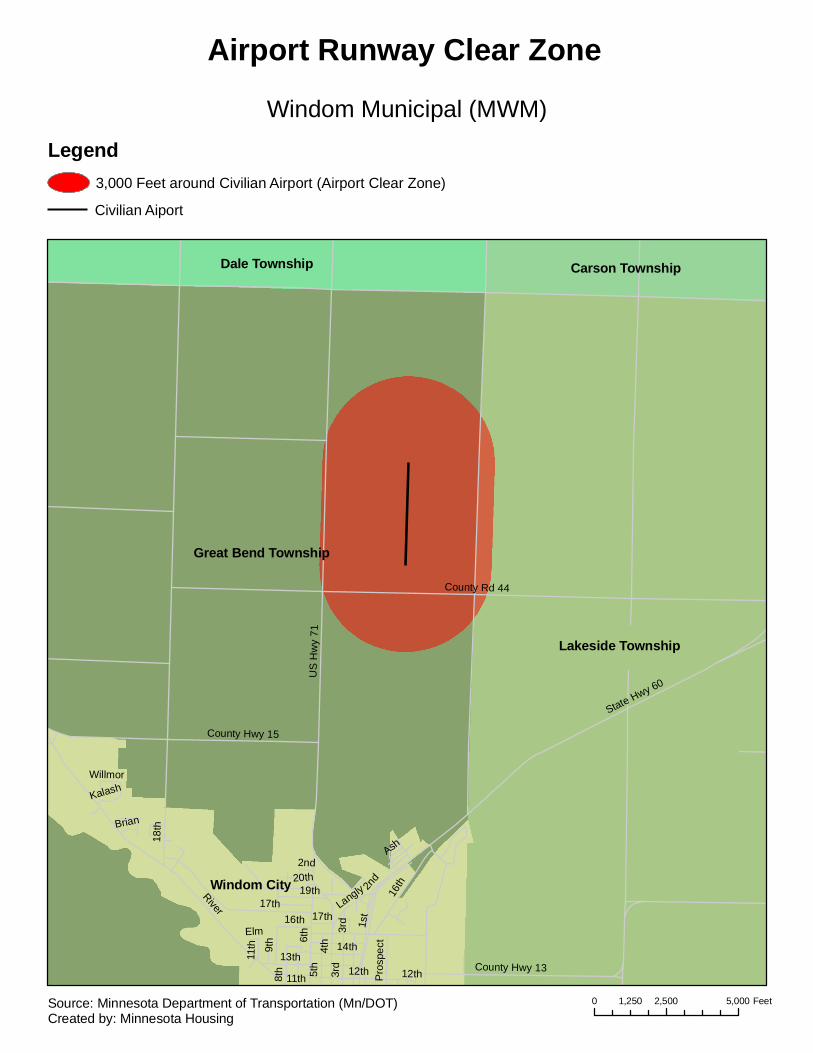
Great Bend Township
Lakeside Township
Windom City
Dale Township Carson Township
US
Hw
y 71
River
1st
4th
State Hwy 60
16th
6th
17th
County Rd 44
County Hwy 133rd
13th
County Hwy 15
5th
20th
9th 14th
8th
19thLangly
18th
2nd
Pro
spec
t
11th
Ash
Brian
Kalash
12th
Elm
Willmor
12th11th
2nd
3rd17th16th
Windom Municipal (MWM)
Airport Runway Clear Zone
Legend3,000 Feet around Civilian Airport (Airport Clear Zone)
Civilian Aiport
0 2,500 5,0001,250 FeetSource: Minnesota Department of Transportation (Mn/DOT)Created by: Minnesota Housing
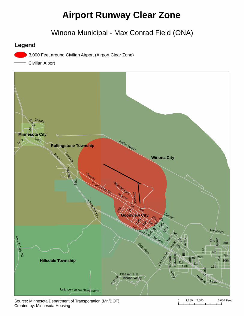
Winona City
Rollingstone Township
Hillsdale Township
Goodview City
Minnesota City
5th
US Hwy 61
9th 8th
Prairie Island
Service
6th
12th
Winona
Bridge
Vila
Lake
US H
wy 1
4
54th
Riverview
Pelze
r
41st
Mill
County Hwy 32
44th
County Rd 129
Gou
ld
Goodview
13th
Orr
in
Theurer
7th
10th
Unknown or No Streetname
3rd
46th
Pleasant Hill
Maur-l
Heights
39th
Lee
Knopp Valley
County H
wy 23
37th
71st
11th
Fairf
ax
Kerry
4th
Elm
40th
Dakota
Calew
ski
Sebo
Saehler
2nd
Cla
rksH
iaw
atha Park
Industrial Park
Dress
er
Deb
orah
7th
4th
7th
11th
Lake
5th
Theurer
9th
Lake
6th
5th
7th
Theurer
Winona Municipal - Max Conrad Field (ONA)
Airport Runway Clear Zone
Legend3,000 Feet around Civilian Airport (Airport Clear Zone)
Civilian Aiport
0 2,500 5,0001,250 FeetSource: Minnesota Department of Transportation (Mn/DOT)Created by: Minnesota Housing
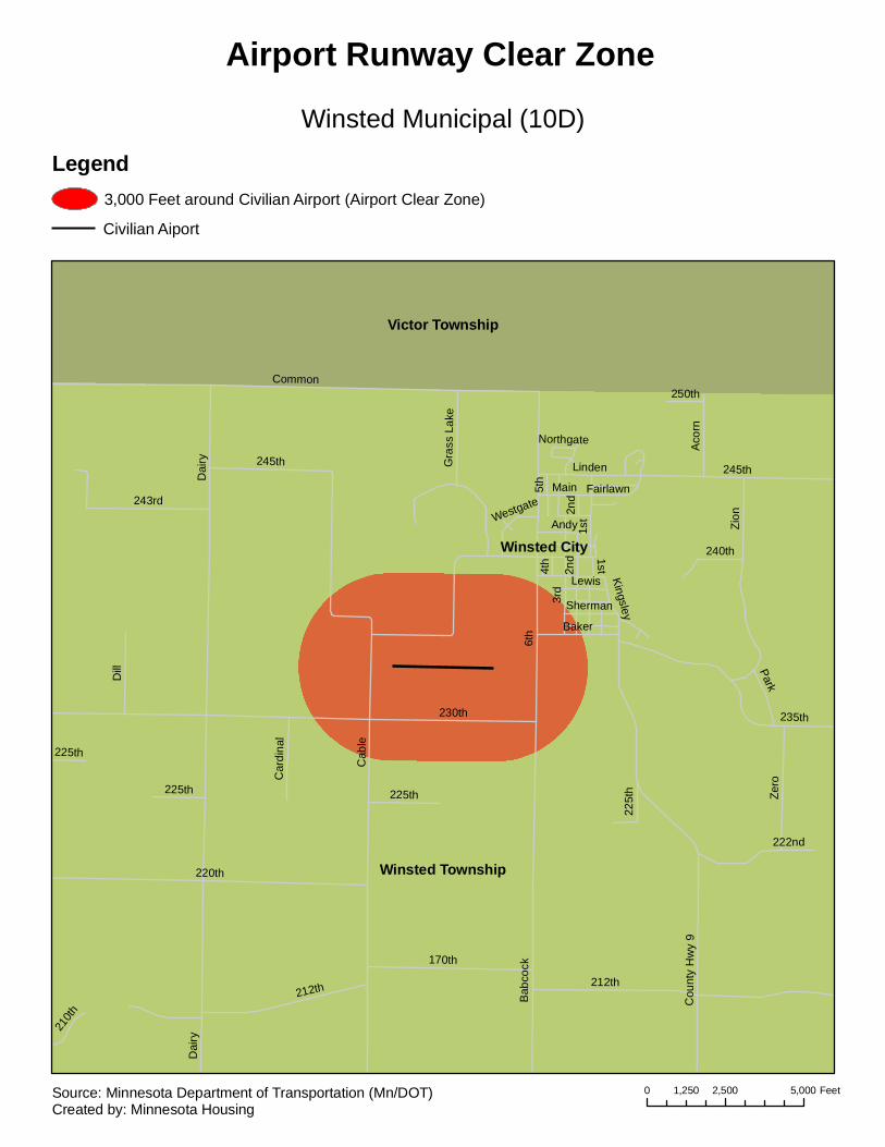
Winsted Township
Victor Township
Winsted City
Dai
ry
6th
Cab
le
230th
220th
Common
Zion
212th
235th
Bab
cock
3rd
Cou
nty
Hw
y 9
170th
Zero
Dill
243rd
Gra
ss L
ake
Main
245th
222nd
Linden
Aco
rn
Baker
Park
225th
240th
Andy
Car
dina
l
Lewis
210th
Kingsley
5th
4th
250th
1st
Fairlawn
Sherman
Westgate 2nd
Northgate
Dai
ry
2nd
225t
h225th
212th
225th
245th
1st
Winsted Municipal (10D)
Airport Runway Clear Zone
Legend3,000 Feet around Civilian Airport (Airport Clear Zone)
Civilian Aiport
0 2,500 5,0001,250 FeetSource: Minnesota Department of Transportation (Mn/DOT)Created by: Minnesota Housing

Lorain Township
Worthington City
Elk Township
Worthington Township
Hersey Township
I-90
Clara
State Hwy 60U
S H
wy
59
1st9th
27th
Cou
nty
Hw
y 3
13th
7th
5thLake
Diagonal
4th
Hum
ista
n
Park
DoverOxford
Miller
3rd 2nd
14th
12th
Row
e Ryan
Gra
nd Dou
glas
County Hwy 35
Mcm
illan
6th
Tow
er
31st
Om
ahaSm
ith
Cecilee
8th
Clary
Stower
Milt
on
Miles
10th
Spr
ing
Elm
woo
d
Cou
nty
Hw
y 5
Turn
er Stra
it
11th
Industrial
Kragness
Clif
ton
Mar
ine
Hum
isto
n
Liberty
Ape
l
Eleanor
Nobles
Hagge
Sky
lineDarling
Lakehill
Roos
Shel
l
29th
I-90
Sprin
g
Clary1st
Worthington Municipal (OTG)
Airport Runway Clear Zone
Legend3,000 Feet around Civilian Airport (Airport Clear Zone)
Civilian Aiport
0 2,500 5,0001,250 FeetSource: Minnesota Department of Transportation (Mn/DOT)Created by: Minnesota Housing
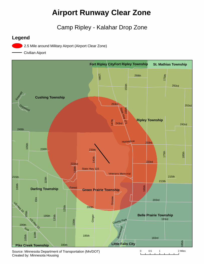
Ripley Township
Darling Township
Cushing Township
Green Prairie Township
Belle Prairie Township
St. Mathias TownshipFort Ripley TownshipFort Ripley City
Pike Creek Township Little Falls City
165t
h
175t
h
190th
263rd
185t
h
Elm
183rd
Gin
ger
193rd
State Hw
y 371
213th
233rd
203rd
223rd
125t
h Gro
use
200th
100t
h
195th
State Hwy 115
155t
h
253rd
Forest
US Hwy 10
105t
h
243rd
Eva
130t
h
120t
h
230th
180th
268th
140t
h
139th
240th
115t
h
Emer
ald
Riv
erw
ood
215th
110t
h
Dogwood14
7th
Veterans Memorial
222nd
County Park
Horseshoe
175t
h
215th
105t
h10
5th
155t
h
230th
185t
h
243rd
253rd
US Hwy 10
185th
130t
h
Camp Ripley - Kalahar Drop Zone
Airport Runway Clear Zone
Legend2.5 Mile around Military Airport (Airport Clear Zone)
Civilian Aiport
0 1 20.5 MilesSource: Minnesota Department of Transportation (Mn/DOT)Created by: Minnesota Housing