Embed Size (px)
Citation preview

I
COMMONWEALTH OF MASSACHUSETTS MASSACHUSETTS DEPARTMENT OF TRANSPORTATION
STANDARD OPERATING PROCEDURES
SUBJECT: REDUCED SALT POLICY
S.O.P. NO .
HMD-01-01-1-000
PAGE 1 OF 16
Distribution: Statewide
EFFECTIVE ISSUED
April 1, 2014 APPROVED
if.'4'.i)~ PURPOSE To establish reduced salt zones for the purpose of minimizing sodium and chloride effects on an industrial or potable water supply. To clearly identify and delineate the limits of each reduced salt zone in each district, as well as identify the materials and application rates to be used.
RESPONSIBILITY The District Highway Director (DHD) is directly responsible for maintaining this policy and ensuring that the procedures outlined are followed. The operation and maintenance of reduced salt zones requires increased material expenditures due to the use of calcium chloride, magnesium chloride and/ or salt-sand mixes, as well as the cost for increased supervision and sand disposal. All locations shall be closely supervised during all storm events. The District shall be responsible for ensuring that chemicals for the reduced salt zones are available, and that the maps are distributed in a timely manner to appropriate personnel including privatized forces for increased awareness.
NOTE: In order to maintain public safety and at the direction of the Highway Administrator or his designee, one or more applications of straight Salt, Pre-Mix or 50/50 may be applied at 240 lbs. per lane mile.
The Snow & Ice Materials Usage Committee (S&IMUC) shall make recommendations for the addition, deletion or modification of reduced salt zones. Reduced salt zones shall only be established based on scientific data as required by SOP, ENV-01-30-1-000. The failure of a municipality or public water supplier to provide the regular monitoring data as required by the aforementioned SOP to demonstrate the effectiveness of the reduced salt zone may be grounds for MassDOT to discontinue treating the corresponding section of highway as a reduced salt zone.

S.O.P. NO. HMD-01-01-1-000
EFFECTIVEPAGE 2 OF 16April 1, 2014
DEFINITIONS
Salt or Sodium Chloride is the primary deicer utilized by MassDOT due to its chemical deicing properties and cost effectiveness; at 240-320 F. Applied at 240 lbs per lane mile, salt is the most cost effective and best deicer available. It is a crystal that has to become a liquid or brine in order to work effectively. Salt transforms into brine with the addition of heat, moisture and time.
Pre-wetted Salt is sodium chloride sprayed with Liquid Magnesium Chloride or Blended Brine. The application rate is 8-10 gallons per ton of salt. Best utilized by spraying on salt from 300 F and below, and on all applications of material. The act of pre-wetting serves several functions: it reduces bounce and scatter, and accelerates the salt going from a solid to solution or brine.
Pre-mix is a combination of Sodium Chloride and Flake Calcium Chloride (Solid). The ratio of the two products is 4:1, 80% Sodium Chloride and 20% Calcium Chloride. Pre-mix combined with sand is used in some of the reduced salt zones.
50/50 Mix is a 1:1 mixture of sand with a deicing material. The deicing material may be salt or pre-mix. This material is not the most effective deicer but is used in reduced salt zones to reduce sodium and chlorides into the environment. This mixture is sometimes used during sleet or freezing rain events.
Liquid Magnesium Chloride 30% a corrosion inhibited deicing agent. A blend of magnesium chloride 30% and an environmentally friendly (Amine) additive creating a blended chemical 70% less corrosive than conventional deicers. The eutectic temperature is about -28°F at a concentration of 21.6%. Its ice melting capacity is about 40% greater than CaCl2. Utilized for Pre-treating of roads or Pre-wetting of all spread material.
Pre-treatment a proactive strategy designed to prevent a bond between the snow and ice and road surface. This is achieved by the direct application of liquid. The typical application rate is between 20-30 gallons per lane mile. Pre-treatment is normally done on pavement temperatures of between 15300F or 300F and falling.
Blended Brine 23.3% salt to water is a cost effective deicing solution used as a blend with liquid MgCl (85% salt). It is applied at a rate of 40-50 gallons per lane mile and used for pre-wetting salt or direct application pre-treatment.
Sand A clean intert, hard material free of organic material with no melting capabilities. Sand is intended to increase friction between vehicles and the pavement. The sand is typically mixed with pre-mix on a 1:1 basis. Because of the environmental and economic impact, MassDOT restricts the use of sand in our operations to reduced salt zones and in extremely cold temperatures.

S.O.P. NO. HMD-01-01-1-000
EFFECTIVEPAGE 3 OF 16April 1, 2014
District I
Map #
Type of Water Supply Town Route Boundaries
Lane Miles Materials Application Rate
D1-01 Private Becket Route 8 Carter Road to Washington TL 2
Pre-Mix and/or Salt : Sand (1:1) 240 lbs/Ln Mile Pre-Wet w/ Liquid CaCl, Liquid MgCl or
Blended Brine 8-10 Gal/Ln Mile
Pre-Treat w/ Liquid CaCl, Liquid MgCl or Blended Brine 30 Gal/Ln Mile
D1-02 Private Cummington Route 9 From the Dudley Manor Bridge &
continuing to the westerly entrance to Cummington Village.
3.7
Pre-Mix and/or Salt : Sand (1:1) 240 lbs/Ln Mile Pre-Wet w/ Liquid CaCl, Liquid MgCl or
Blended Brine 8-10 Gal/Ln Mile
Pre-Treat w/ Liquid CaCl, Liquid MgCl or Blended Brine 30 Gal/Ln Mile
D1-03 Private Goshen Route 9
From the intersection of Ball Road, continuing easterly to
approximately 2,500 feet east of the Whale Inn.
6.2
Pre-Mix and/or Salt : Sand (1:1) 240 lbs/Ln Mile Pre-Wet w/ Liquid CaCl, Liquid MgCl or
Blended Brine 8-10 Gal/Ln Mile
Pre-Treat w/ Liquid CaCl, Liquid MgCl or Blended Brine 30 Gal/Ln Mile
D1-03 Private Goshen Route 112 From the end of town road,
northerly to the intersection with Maple Ave.
6.2
Pre-Mix and/or Salt : Sand (1:1) 240 lbs/Ln Mile Pre-Wet w/ Liquid CaCl, Liquid MgCl or
Blended Brine 8-10 Gal/Ln Mile
Pre-Treat w/ Liquid CaCl, Liquid MgCl or Blended Brine 30 Gal/Ln Mile

Map #
D2-01
Type of Water Supply
Public
HMD-01-01-1-000 S.O.P. NO.
Town
Erving
Route
Route 2
Boundaries
District 2
From east end of the French King Bridge, easterly to approximately 200 feet prior to the Moore Street
overpass.
EFFECTIVE April 1, 2014
Lane Miles
3
Materials
Pre-Mix and/or Salt : Sand (1:1)
Pre-Wet w/ Liquid CaCl, Liquid MgCl or Blended Brine
Pre-Treat w/ Liquid CaCl, Liquid MgCl or Blended Brine
Application Rate
240 lbs/Ln Mile
8-10 Gal/Ln Mile
30 Gal/Ln Mile
PAGE 4 OF 16
D2-02
D2-03 Private
Public Erving
Granby
South Hadley
Route 63
Route 202
of Poplar Mountain Road.
From the Belchertown/Granby TL, westerly to the Granby/South
Hadley TL.
From the intersection with Kennedy Road northerly to the intersection
17
3.4
Pre-Treat w/ Liquid CaCl, Liquid MgCl or Blended Brine
Pre-Mix and/or Salt : Sand (1:1)
Pre-Mix and/or Salt : Sand (1:1)
Pre-Wet w/ Liquid CaCl, Liquid MgCl or Blended Brine
Pre-Wet w/ Liquid CaCl, Liquid MgCl or Blended Brine
Pre-Treat w/ Liquid CaCl, Liquid MgCl or Blended Brine
Pre-Mix and/or Salt : Sand (1:1) Pre-Wet w/ Liquid CaCl, Liquid MgCl or
Blended Brine
30 Gal/Ln Mile
240 lbs/Ln Mile
240 lbs/Ln Mile
8-10 Gal/Ln Mile
8-10 Gal/Ln Mile
30 Gal/Ln Mile
240 lbs/Ln Mile
8-10 Gal/Ln Mile D2-03 Private
D2-04 Private Orange
Route 202
Route 2
including ramps.
From approximately 250 feet east of the Orange/Wendell TL to the
intersection with Route 202,
From the Granby/South Hadley TL to the intersection with Route 33.
14.5
17
Pre-Treat w/ Liquid CaCl, Liquid MgCl or Blended Brine
Pre-Treat w/ Liquid CaCl, Liquid MgCl or Blended Brine
Pre-Mix and/or Salt : Sand (1:1)
Pre-Wet w/ Liquid CaCl, Liquid MgCl or Blended Brine
30 Gal/Ln Mile
30 Gal/Ln Mile
240 lbs/Ln Mile
8-10 Gal/Ln Mile
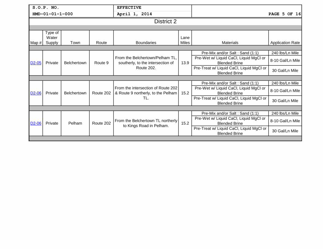
S.O.P. NO. HMD-01-01-1-000
EFFECTIVEPAGE 5 OF 16April 1, 2014
District 2
Map #
Type of Water Supply Town Route Boundaries
Lane Miles Materials Application Rate
D2-05 Private Belchertown Route 9From the Belchertown/Pelham TL,
southerly, to the intersection of Route 202.
13.9
Pre-Mix and/or Salt : Sand (1:1) 240 lbs/Ln Mile Pre-Wet w/ Liquid CaCl, Liquid MgCl or
Blended Brine 8-10 Gal/Ln Mile
Pre-Treat w/ Liquid CaCl, Liquid MgCl or Blended Brine 30 Gal/Ln Mile
D2-06 Private Belchertown Route 202 From the intersection of Route 202 & Route 9 northerly, to the Pelham
TL. 15.2
Pre-Mix and/or Salt : Sand (1:1) 240 lbs/Ln Mile Pre-Wet w/ Liquid CaCl, Liquid MgCl or
Blended Brine 8-10 Gal/Ln Mile
Pre-Treat w/ Liquid CaCl, Liquid MgCl or Blended Brine 30 Gal/Ln Mile
D2-06 Private Pelham Route 202 From the Belchertown TL northerly to Kings Road in Pelham. 15.2
Pre-Mix and/or Salt : Sand (1:1) 240 lbs/Ln Mile Pre-Wet w/ Liquid CaCl, Liquid MgCl or
Blended Brine 8-10 Gal/Ln Mile
Pre-Treat w/ Liquid CaCl, Liquid MgCl or Blended Brine 30 Gal/Ln Mile

S.O.P. NO. HMD-01-01-1-000
EFFECTIVE PAGE 6 OF 16April 1, 2014
District 3
Map #
Type of Water Supply Town Route Boundaries
Lane Miles Materials Application Rate
D301A Public Auburn Route 12 From the Oxford TL to to the
Worcester TL. 27.7
Pre-Mix and/or Salt : Sand (1:1) 240 lbs/Ln Mile
Pre-Wet w/ Liquid CaCl, Liquid MgCl or Blended Brine 8-10 Gal/Ln Mile
Pre-Treat w/ Liquid CaCl, Liquid MgCl or Blended Brine 30 Gal/Ln Mile
D301B Public Oxford Route 12 From the Oxford center of town
northerly to the Auburn TL. 27.7
Pre-Mix and/or Salt : Sand (1:1) 240 lbs/Ln Mile Pre-Wet w/ Liquid CaCl, Liquid MgCl or
Blended Brine 8-10 Gal/Ln Mile
Pre-Treat w/ Liquid CaCl, Liquid MgCl or Blended Brine 30 Gal/Ln Mile
D3-02 Public Boylston Route 70 From Shrewsbury TL to the Clinton TL. 18
Pre-Mix and/or Salt : Sand (1:1) 240 lbs/Ln Mile Pre-Wet w/ Liquid CaCl, Liquid MgCl or
Blended Brine 8-10 Gal/Ln Mile
Pre-Treat w/ Liquid CaCl, Liquid MgCl or Blended Brine 30 Gal/Ln Mile
D302A Public Clinton Route 70
From the Clinton/Boylston TL to the end of center of town in
Clinton. 18
Pre-Mix and/or Salt : Sand (1:1) 240 lbs/Ln Mile Pre-Wet w/ Liquid CaCl, Liquid MgCl or
Blended Brine 8-10 Gal/Ln Mile
Pre-Treat w/ Liquid CaCl, Liquid MgCl or Blended Brine 30 Gal/Ln Mile
D3-02 Public Shrewsbury Route 70 From the Worcester/Shrewsbury TL to the Shrewsbury/Boylston TL. 18
Pre-Mix and/or Salt : Sand (1:1) 240 lbs/Ln Mile Pre-Wet w/ Liquid CaCl, Liquid MgCl or
Blended Brine 8-10 Gal/Ln Mile
Pre-Treat w/ Liquid CaCl, Liquid MgCl or Blended Brine 30 Gal/Ln Mile
D3-03 Private Charlton Route 20 From the intersection of Depot
Road, westerly to the junction of Route 169.
6
Pre-Mix and/or Salt : Sand (1:1) 240 lbs/Ln Mile Pre-Wet w/ Liquid CaCl, Liquid MgCl or
Blended Brine 8-10 Gal/Ln Mile
Pre-Treat w/ Liquid CaCl, Liquid MgCl or Blended Brine 30 Gal/Ln Mile

S.O.P. NO. HMD-01-01-1-000
EFFECTIVEPAGE 7 OF 16April 1, 2014
District 3
Map #
Type of Water Supply Town Route Boundaries
Lane Miles Materials Application Rate
D3-04 Public West Boylston Route 12 From the intersection with Central Street, northerly to the summit of
Balderellis Hill. 5.3
Pre-Mix and/or Salt : Sand (1:1) 240 lbs/Ln Mile Pre-Wet w/ Liquid CaCl, Liquid MgCl or
Blended Brine 8-10 Gal/Ln Mile
Pre-Treat w/ Liquid CaCl, Liquid MgCl or Blended Brine 30 Gal/Ln Mile
D3-05 Private West Boylston Route 110 From the intersection with Route 12 to the Clinton TL. 12.4
Pre-Mix and/or Salt : Sand (1:1) 240 lbs/Ln Mile Pre-Wet w/ Liquid CaCl, Liquid MgCl or
Blended Brine 8-10 Gal/Ln Mile
Pre-Treat w/ Liquid CaCl, Liquid MgCl or Blended Brine 30 Gal/Ln Mile

HMD-01-01-1-000 S.O.P. NO. EFFECTIVE
PAGE 8 OF 16April 1, 2014
District 4
Map #
Type of Water Supply Town Route Boundaries
Lane Miles Materials Application Rate
D4-01, Public Lincoln Route 2A From Hanscomb Dr. in Lincoln to the Lexington TL. 1.63
Pre-Mix and/or Salt : Sand (1:1) 240 lbs/Ln Mile Pre-Wet w/ Liquid CaCl, Liquid MgCl or
Blended Brine 8-10 Gal/Ln Mile A-B
Pre-Treat w/ Liquid CaCl, Liquid MgCl or Blended Brine 30 Gal/Ln Mile
D4-01, Public Lexington Route 2A From the Lincoln TL to the
Arlington TL, including the 128/2A interchange.
15.05
Pre-Mix and/or Salt : Sand (1:1) 240 lbs/Ln Mile Pre-Wet w/ Liquid CaCl, Liquid MgCl or
Blended Brine 8-10 Gal/Ln Mile A-B
Pre-Treat w/ Liquid CaCl, Liquid MgCl or Blended Brine 30 Gal/Ln Mile
D4-01, Public Arlington Route 2A From Lexington TL to Brattle Rd., Arlington. 7.63
Pre-Mix and/or Salt : Sand (1:1) 240 lbs/Ln Mile Pre-Wet w/ Liquid CaCl, Liquid MgCl or
Blended Brine 8-10 Gal/Ln Mile A-B
Pre-Treat w/ Liquid CaCl, Liquid MgCl or Blended Brine 30 Gal/Ln Mile
D4-02, Public Lincoln Route 2 From Bedford Rd. in Lincoln to Lexington TL. 7.11
Pre-Mix and/or Salt : Sand (1:1) 240 lbs/Ln Mile Pre-Wet w/ Liquid CaCl, Liquid MgCl or
Blended Brine 8-10 Gal/Ln Mile A-B
Pre-Treat w/ Liquid CaCl, Liquid MgCl or Blended Brine 30 Gal/Ln Mile
D4-02, Public Lexington Route 2 From Lincoln TL to Pleasant St. in Lexington (Exit 55), including the
128/2 interchange. 19.82
Pre-Mix and/or Salt : Sand (1:1) 240 lbs/Ln Mile Pre-Wet w/ Liquid CaCl, Liquid MgCl or
Blended Brine 8-10 Gal/Ln Mile A-B
Pre-Treat w/ Liquid CaCl, Liquid MgCl or Blended Brine 30 Gal/Ln Mile
D4-03, Public Lexington Waltham Route 128
From Route 4/225 (exit 31), to Route 20 (Exit 26), including all
interchanges and all related ramps. 67.19
Salt 240 lbs/Ln Mile Pre-Wet w/ Liquid CaCl, Liquid MgCl or
Blended Brine 8-10 Gal/Ln Mile A-F
Pre-Treat w/ Liquid CaCl, Liquid MgCl or Blended Brine 30 Gal/Ln Mile

HMD-01-01-1-000 S.O.P. NO. EFFECTIVE
PAGE 9 OF 16April 1, 2014
District 4
Map #
Type of Water Supply Town Route Boundaries
Lane Miles Materials Application Rate
D4-05, A-C Public Chelmsford Route 3
From Route 129 (Exit 29) to Route 40 (Exit 33) including ramps and
feeder lanes. 39
Pre-Mix and/or Salt : Sand (1:1) 240 lbs/Ln Mile Pre-Wet w/ Liquid CaCl, Liquid MgCl or
Blended Brine 8-10 Gal/Ln Mile
Pre-Treat w/ Liquid CaCl, Liquid MgCl or Blended Brine 30 Gal/Ln Mile
D4-06 Public Chelmsford Route 3A Route 4
From the Chelmsford High School to the Chelmford/Tyngsborough
TL. 11.4
Pre-Mix and/or Salt : Sand (1:1) 240 lbs/Ln Mile Pre-Wet w/ Liquid CaCl, Liquid MgCl or
Blended Brine 8-10 Gal/Ln Mile
Pre-Treat w/ Liquid CaCl, Liquid MgCl or Blended Brine 30 Gal/Ln Mile
D4-07 Public Lowell Chelmsford
Lowell Connector
From Gorham Street to Route 3, including all ramps. 30.4
Pre-Mix and/or Salt : Sand (1:1) 240 lbs/Ln Mile Pre-Wet w/ Liquid CaCl, Liquid MgCl or
Blended Brine 8-10 Gal/Ln Mile
Pre-Treat w/ Liquid CaCl, Liquid MgCl or Blended Brine 30 Gal/Ln Mile
D4-08 Public Chelmsford Lowell Route 110 From Fletcher Street, Chelmsford
to Industrial Ave., Lowell. 6.5
Pre-Mix and/or Salt : Sand (1:1) 240 lbs/Ln Mile Pre-Wet w/ Liquid CaCl, Liquid MgCl or
Blended Brine 8-10 Gal/Ln Mile
Pre-Treat w/ Liquid CaCl, Liquid MgCl or Blended Brine 30 Gal/Ln Mile
D4-09, A-C Industrial Lynnfield
Peabody Route 128From Lowell Street, Peabody (Exit 26) to Salem Street, Lynnfield (Exit 42) and all related ramp systems.
63.2
Pre-Mix and/or Salt : Sand (1:1) 240 lbs/ln Mile Pre-Wet w/ Liquid CaCl, Liquid MgCl or
Blended Brine 8-10 Gal/Ln Mile
Pre-Treat w/ Liquid CaCl, Liquid MgCl or Blended Brine 30 Gal/Ln Mile
D4-10 Industrial Lynnfield Peabody Lynn Route 129
Route From our Lady of Assumption Church in Lynnfield to
St Mary's Cemetery in Lynn. 8.2
Pre-Mix and/or Salt : Sand (1:1) 240 lbs/Ln Mile Pre-Wet w/ Liquid CaCl, Liquid MgCl or
Blended Brine 8-10 Gal/Ln Mile
Pre-Treat w/ Liquid CaCl, Liquid MgCl or Blended Brine 30 Gal/Ln Mile

S.O.P. NO. HMD-01-01-1-000
EFFECTIVEPAGE 10 OF 16April 1, 2014
District 4
Map #
Type of Water Supply Town Route Boundaries
Lane Miles Materials Application Rate
D4-11 Industial Peabody Route 95
The long ramps connecting Route 95 to Route 128, beginning and
ending approximately at the Forest Street overpass.
10.0
Pre-Mix and/or Salt : Sand (1:1) 240 lbs/Ln Mile Pre-Wet w/ Liquid CaCl, Liquid MgCl or
Blended Brine 8-10 Gal/Ln Mile
Pre-Treat w/ Liquid CaCl, Liquid MgCl or Blended Brine 30 Gal/Ln Mile
D4-12
D4-13 Public
Industrial Lynnfield Peabody
Andover Route 93
Route 1/95 Interchange
Route 1 interchange with Route 95 from the Route 1 Jughandle to and
including Goodwin Circle.
From Dascomb Road, Tewksbury (Exit 42) to River Road, Andover
(Exit 45). 38.8
13.4
Pre-Mix and/or Salt : Sand (1:1) 240 lbs/Ln Mile Pre-Wet w/ Liquid CaCl, Liquid MgCl or
Blended Brine 8-10 Gal/Ln Mile
Pre-Treat w/ Liquid CaCl, Liquid MgCl or Blended Brine
Salt : Sand (1:1)
30 Gal/Ln Mile
240 lbs/ln Mile Pre-Wet w/ Liquid CaCl, Liquid MgCl or
Blended Brine 8-10 Gal/Ln Mile
Pre-Treat w/ Liquid CaCl, Liquid MgCl or Blended Brine 30 Gal/Ln Mile
D4-14 Public Andover Route 495 From Route 133 (Exit 39) to I-93 (Exit 40), including ramp systems. 19.6
Salt : Sand (1:1) 240 lbs/Ln Mile Pre-Wet w/ Liquid CaCl, Liquid MgCl or
Blended Brine 8-10 Gal/Ln Mile
Pre-Treat w/ Liquid CaCl, Liquid MgCl or Blended Brine 30 Gal/Ln Mile
D4-15, Private
Danvers Topsfield Middleton Boxford Rowley
Route 95 From the Ferncroft Rotary,
Danvers (Exit 50) to Route 133, Georgetown (Exit 54).
45.6
Salt : Sand (1:1) 240 lbs/ln Mile
Pre-Wet w/ Liquid Magnesium Chloride 8-10 Gal/Ln Mile A-C Pre-Treat w/ Liquid Magnesium Chloride 30 Gal/Ln Mile

HMD-01-01-1-000 S.O.P. NO. EFFECTIVE
PAGE 11 OF 16April 1, 2014
District 5
Map #
Type of Water Supply Town Route Boundaries
Lane Miles Materials Application Rate
D5-01 Public Avon Harrison Blvd. From Route 24 to Route 28. 16.8
Pre-Mix and/or Salt : Sand (1:1) 240 lbs/Ln Mile Pre-Wet w/ Liquid CaCl, Liquid MgCl or
Blended Brine 8-10 Gal/Ln Mile
Pre-Treat w/ Liquid CaCl, Liquid MgCl or Blended Brine 30 Gal/Ln Mile
D5-01 Public Avon Route 28 From Randolph TL to Route 37. 16.8
Pre-Mix and/or Salt : Sand (1:1) 240 lbs/Ln Mile Pre-Wet w/ Liquid CaCl, Liquid MgCl or
Blended Brine 8-10 Gal/Ln Mile
Pre-Treat w/ Liquid CaCl, Liquid MgCl or Blended Brine 30 Gal/Ln Mile
D5-02 Private Freetown Lakeville Taunton
Route 140
From the junction of Chace Road, (Exit 8) in Freetown, northerly, to
the intersection of Route 79 in Taunton (Exit 10).
38.6
Pre-Mix and/or Salt : Sand (1:1) 240 lbs/Ln Mile
Pre-Wet w/ Liquid CaCl, Liquid MgCl or Blended Brine 8-10 Gal/Ln Mile
Pre-Treat w/ Liquid CaCl, Liquid MgCl or Blended Brine 30 Gal/Ln Mile
D5-03 PrivateFreetown Lakeville Taunton
Route 18 & County
Road (Old Route 140)
County Road (Old Route 140), starting @ the New
Bedford/Freetown TL to Route 79 in Lakeville.
19.1
Pre-Mix and/or Salt : Sand (1:1) 240 lbs/Ln Mile
Pre-Wet w/ Liquid CaCl, Liquid MgCl or Blended Brine 8-10 Gal/Ln Mile
Pre-Treat w/ Liquid CaCl, Liquid MgCl or Blended Brine 30 Gal/Ln Mile
D5-04 Public Middleboro Route 28 From the junction of Route 495
(Exit 3) to the junction of Route 44 rotary (Exit 6).
21.3
Pre-Mix and/or Salt : Sand (1:1) 240 lbs/Ln Mile Pre-Wet w/ Liquid CaCl, Liquid MgCl or
Blended Brine 8-10 Gal/Ln Mile
Pre-Treat w/ Liquid CaCl, Liquid MgCl or Blended Brine 30 Gal/Ln Mile
Public Middleboro D5-05 Route 495 From the interchange of Route 28 to the interchange with Route 44. 43.9
Pre-Mix and/or Salt : Sand (1:1) 240 lbs/Ln Mile Pre-Wet w/ Liquid CaCl, Liquid MgCl or
Blended Brine 8-10 Gal/Ln Mile
Pre-Treat w/ Liquid CaCl, Liquid MgCl or Blended Brine 30 Gal/Ln Mile

S.O.P. NO. HMD-01-01-1-000
EFFECTIVEPAGE 12 OF 16April 1, 2014
District 5
Map #
Type of Water Supply Town Route Boundaries
Lane Miles Materials Application Rate
D5-06 Public North Attleboro Route 1
From the Attleboro/ North Attleboro TL northerly to the intersection of Route 120, Hoppin Hill Ave., in
North Attleboro.
10
Pre-Mix and/or Salt : Sand (1:1) 240 lbs/Ln Mile
Pre-Wet w/ Liquid CaCl, Liquid MgCl or Blended Brine 8-10 Gal/Ln Mile
Pre-Treat w/ Liquid CaCl, Liquid MgCl or Blended Brine 30 Gal/Ln Mile
D5-07 Public Attleboro Route 95
From Route 95 / 295 interchange (Exit 4) extending southerly to &
including the Route 123 interchange (Exit 3), except for the ramp from Route 95 North Bound to Route 123 East Bound & the
ramp from Route 123 West Bound to Route 95 North Bound.
14.7
Pre-Mix and/or Salt : Sand (1:1) 240 lbs/Ln Mile
Pre-Wet w/ Liquid CaCl, Liquid MgCl or Blended Brine 8-10 Gal/Ln Mile
Pre-Treat w/ Liquid CaCl, Liquid MgCl or Blended Brine 30 Gal/Ln Mile
D5-08 Public North Attleboro Route 295
From and including the interchange @ Route 1 (Exit 1) northerly to Route 95 (Exit 2),
including the ramp from Route 295 NB to Route 95 SB and the ramp from Route 95 NB to Route 295
SB.
18.6
Pre-Mix and/or Salt : Sand (1:1) 240 lbs/Ln Mile
Pre-Wet w/ Liquid CaCl, Liquid MgCl or Blended Brine 8-10 Gal/Ln Mile
Pre-Treat w/ Liquid CaCl, Liquid MgCl or Blended Brine 30 Gal/Ln Mile

S.O.P. NO. HMD-01-01-1-000
EFFECTIVEPAGE 13 OF 16April 1, 2014
District 5
Map #
Type of Water Supply Town Route Boundaries
Lane Miles Materials Application Rate
D5-09, Public & Private
Bourne Sandwich Barnstable
Dennis Harwich Brewster Orleans Eastham Wellfleet
Truro Provincetown
Route 6 From Sagamore Bridge, Route 6 in
Bourne to Province Land Road, Provincetown.
277.9
Pre-Mix and/or Salt : Sand (1:1) 240 lbs/Ln Mile
Pre-Wet w/ Liquid CaCl, Liquid MgCl or Blended Brine 8-10 Gal/Ln Mile
A-B
Pre-Treat w/ Liquid CaCl, Liquid MgCl or Blended Brine 30 Gal/Ln Mile
D5-10, Public & Private
Falmouth Bourne
Route 28 (Palmer
Ave.)
From the Cape Cod Canal to the end of the State Highway in
Falmouth. 97
Pre-Mix and/or Salt : Sand (1:1) 240 lbs/Ln Mile Pre-Wet w/ Liquid CaCl, Liquid MgCl or
Blended Brine 8-10 Gal/Ln Mile A-C
Pre-Treat w/ Liquid CaCl, Liquid MgCl or Blended Brine 30 Gal/Ln Mile
D5-11 Public Falmouth Wood's Hole Road 14.5
From the intersection of North Main Street & Route 28 (Palmer
Avenue) to Water Street in Falmouth.
Pre-Mix and/or Salt : Sand (1:1) 240 lbs/Ln Mile
Pre-Wet w/ Liquid CaCl, Liquid MgCl or Blended Brine 8-10 Gal/Ln Mile
Pre-Treat w/ Liquid CaCl, Liquid MgCl or Blended Brine 30 Gal/Ln Mile

HMD-01-01-1-000 S.O.P. NO. EFFECTIVE
PAGE 14 OF 16April 1, 2014
District 5
Map #
Type of Water Supply Town Route Boundaries
Lane Miles Materials Application Rate
D5-12 Public
Harwich Dennis
Yarmouth Barnstable
Route 28 From the junction of Route 132
and Route 28 in Barnstable to the Harwich / Chatham TL.
43.2
Pre-Mix and/or Salt : Sand (1:1) 240 lbs/Ln Mile
Pre-Wet w/ Liquid CaCl, Liquid MgCl or Blended Brine 8-10 Gal/Ln Mile
Pre-Treat w/ Liquid CaCl, Liquid MgCl or Blended Brine 30 Gal/Ln Mile
D5-13, PublicBarnstable Mashpee Falmouth
Route 28 From Falmouth Heights Circle in Falmouth to the junction of Route 28 and Route 132 in Barnstable.
45.08
Pre-Mix and/or Salt : Sand (1:1) 240 lbs/Ln Mile Pre-Wet w/ Liquid CaCl, Liquid MgCl or
Blended Brine 8-10 Gal/Ln Mile A-B
Pre-Treat w/ Liquid CaCl, Liquid MgCl or Blended Brine 30 Gal/Ln Mile
D5-14 Private Chatam Harwich Orleans
Route 28 From the Harwich / Chatham TL to the Orleans Rotary. 31.7
Pre-Mix and/or Salt : Sand (1:1) 240 lbs/Ln Mile Pre-Wet w/ Liquid CaCl, Liquid MgCl or
Blended Brine 8-10 Gal/Ln Mile
Pre-Treat w/ Liquid CaCl, Liquid MgCl or Blended Brine 30 Gal/Ln Mile
D5-15 Public Falmouth Bourne Route 28A
From the junction of Route 28 (McArthur Blvd.) and Roberta Ave.
in Bourne to the junction of Sippewisset Road and Palmer
Ave. in Falmouth.
15.8
Pre-Mix and/or Salt : Sand (1:1) 240 lbs/Ln Mile Pre-Wet w/ Liquid CaCl, Liquid MgCl or
Blended Brine 8-10 Gal/Ln Mile
Pre-Treat w/ Liquid CaCl, Liquid MgCl or Blended Brine 30 Gal/Ln Mile
D5-16 Public
Barnstable Yarmouth
Dennis Brewster Orleans
Route 6A
From the junction of Route 6A and Hyannis Road in Barnstable to the junction of Route 6A and Route 28 (Orleans-Chatham Rd.) in Orleans.
45.1
Pre-Mix and/or Salt : Sand (1:1) 240 lbs/Ln Mile Pre-Wet w/ Liquid CaCl, Liquid MgCl or
Blended Brine 8-10 Gal/Ln Mile
Pre-Treat w/ Liquid CaCl, Liquid MgCl or Blended Brine 30 Gal/Ln Mile
Barnstable Sandwich Bourne
D5-17 Public Route 6A From Bourne, at the State Police rotary, to the junction of Route 6A and Old Jail Lane in Barnstable.
37.5
Pre-Mix and/or Salt : Sand (1:1) 240 lbs/Ln Mile Pre-Wet w/ Liquid CaCl, Liquid MgCl or
Blended Brine 8-10 Gal/Ln Mile
Pre-Treat w/ Liquid CaCl, Liquid MgCl or Blended Brine 30 Gal/Ln Mile

S.O.P. NO. EFFECTIVE HMD-01-01-1-000 April 1, 2014 PAGE 15 OF 16
District 5
Type of Water Lane
Map # Supply Town Route Boundaries Miles Materials Application Rate
From the intersection of Route 6A to approximately 100 feet east of
Tupper Road & from the D5-18 Public Sandwich Route 130 intersection of Shawme Road to 1,000 feet north of Jan Sebastian
Way.
8.8
Pre-Mix and/or Salt : Sand (1:1) Pre-Wet w/ Liquid CaCl, Liquid MgCl or
Blended Brine
Pre-Treat w/ Liquid CaCl, Liquid MgCl or Blended Brine
240 lbs/Ln Mile
8-10 Gal/Ln Mile
30 Gal/Ln Mile
Pre-Mix and/or Salt : Sand (1:1)
D5-19 Public Barnstable Route 132 From the junction of Route 6A and Route 132 to Bearses' Way. 4.1
Pre-Wet w/ Liquid CaCl, Liquid MgCl or Blended Brine
Pre-Treat w/ Liquid CaCl, Liquid MgCl or Blended Brine
240 lbs/Ln Mile
8-10 Gal/Ln Mile
30 Gal/Ln Mile
Wareham D5-20 Public Plymouth
Bourne Route 25
From Exit 1, to approximately 2,100 feet west of the
Bourne Bridge. 58.4
Pre-Mix and/or Salt : Sand (1:1) Pre-Wet w/ Liquid CaCl, Liquid MgCl or
Blended Brine Pre-Treat w/ Liquid CaCl, Liquid MgCl or
Blended Brine
240 lbs/Ln Mile
8-10 Gal/Ln Mile
30 Gal/Ln Mile
D5-21, Public & Martha's Various A-E Private Vineyard
State Road (South Road) West Tisbury Road
Upper Main Street in Edgartown Seaview Avenue
Beach Road New York Avenue
Temahigan Avenue Eastville Avenue
State Road (North Road) West Basin Road
Pre-Mix and/or Salt : Sand (1:1)
101.4 Wet w/ Liquid CaCl, Liquid MgCl or Blended
Pre-Treat w/ Liquid CaCl, Liquid MgCl or Blended Brine
240 lbs/Ln Mile
8-10 Gal/Ln Mile
30 Gal/Ln Mile
Pre-Mix and/or Salt : Sand (1:1) 240 lbs/Ln Mile From the junction of Priest Road, Pre-Wet w/ Liquid CaCl, Liquid MgCl or Public & North Truro and South Hollow Road in North 8-10 Gal/Ln Mile D5-22 6A 22.31 Blended Brine Private Provincetown Truro to the junction of Route 6 Pre-Treat w/ Liquid CaCl, Liquid MgCl or and Snail Road in Provincetown. 30 Gal/Ln Mile Blended Brine

S.O.P. NO. HMD-01-01-1-000
EFFECTIVEPAGE 16 OF 16April 1, 2014
District 6
Map #
Type of Water Supply Town Route Boundaries
Lane Miles Materials Application Rate
D6-01 Public Weston Route 128 From Route 20 (exit 26) to Route 9
(exit 20), including all related interchanges and all related ramps.
80
Pre-Mix and/or Salt : Sand (1:1) 240 lbs/Ln Mile Pre-Wet w/ Liquid CaCl, Liquid MgCl or
Blended Brine 8-10 Gal/Ln Mile
Pre-Treat w/ Liquid CaCl, Liquid MgCl or Blended Brine 30 Gal/Ln Mile
D6-02 Public Weston Waltham Route 20
From the Wayland/Weston TL to Eddy Street, Waltham, including
the 128/20 rotary and ramps. 14.52
Pre-Mix and/or Salt : Sand (1:1) 240 lbs/Ln Mile Pre-Wet w/ Liquid CaCl, Liquid MgCl or
Blended Brine 8-10 Gal/Ln Mile
Pre-Treat w/ Liquid CaCl, Liquid MgCl or Blended Brine 30 Gal/Ln Mile