Embed Size (px)
Citation preview
CENTER FOR INTERNATIONAL FORESTRY RESEARCH CIFOR OCCASIONAL PAPER NO. 15
ISSN 0854-9818
Sep. 1998
Reduced-Impact Logging Guidelines for Lowlandand Hill Dipterocarp Forests in Indonesia
Plinio Sist, Dennis Dykstra, and Robert Fimbel
CENTER FOR INTERNATIONAL FORESTRY RESEARCHoffice address: Jalan CIFOR, Situ Gede, Sindangbarang, Bogor 16680, Indonesiamailing address: P.O. Box 6596 JKPWB, Jakarta 10065, Indonesiatel.: +62 (251) 622622 fax: +62 (251) 622100email: [email protected]:http://www.cgiar.org/cifor

The CGIAR System
The Consultative Group on International Agricultural Research (CGIAR) is an informalassociation of 41 public and private sector donors that supports a network of sixteen interna-tional agricultural research institutes, CIFOR being the newest of these. The Group wasestablished in 1971. The CGIAR Centers are part of a global agricultural research systemwhich endeavours to apply international scientific capacity to solution of the problems of theworldÕs disadvantaged people.
CIFOR
CIFOR was established under the CGIAR system in response to global concerns about thesocial, environmental and economic consequences of loss and degradation of forests. Itoperates through a series of highly decentralised partnerships with key institutions and/orindividuals throughout the developing and industrialised worlds. The nature and duration ofthese partnerships are determined by the specific research problems being addressed. Thisresearch agenda is under constant review and is subject to change as the partners recognisenew opportunities and problems.
CONTENTS
Introduction 1
1. Harvesting plans 11.1. Strategic plan 11.2. Tactical plan 4
2. Developing RIL guidelines within the tactical plan 42.1. Supervising RIL 42.2. Pre-harvesting operations 4
2.2.1. Stock survey 42.2.2. Climber cutting 52.2.3. Topography assessment 62.2.4. Protected areas 62.2.5. Road, landing, and skid trail planning 6
2.2.5.1. Road design 62.2.5.2. Landings 92.2.5.3. Planning the skid trail network 92.2.5.4. Planning for felling 9
2.2.6. Final pre-logging RIL survey 102.2.7. Tactical maps and written plans 10
3. Harvesting operations 103.1. Felling (team, maps, and material) 103.2. Skid trail marking and opening 103.3. Salary system 12
4. Post-harvesting operations 124.1. Rehabilitation of skid trails 124.2. Road closure 124.3. Other post-harvesting operations 13
Conclusions and discussion 13
Literature cited 14
Annex 1: Field assessment guidelines for conservation area designation 15within the strategic plan and tactical planning processes (afterWCS 1998)
Annex 2: Glossary 18

INTRODUCTION
International awareness of escalating deforestationrates has caused many tropical countries, includingIndonesia, to give priority to the attainment of theInternational Tropical Timber Organisations (ITTOÕs)year 2000 objective to bring the forest estate under sus-tainable management. Progress towards sustainableforest management will promote the implementation ofreduced-impact logging (RIL) techniques, which aimto reduce soil disturbance, impacts on wildlife, anddamage to residual trees. RIL has been recently imple-mented and tested in various tropical regions, particu-larly Southeast Asia (Sabah: Pinard and Putz 1996;East Kalimantan: Bertault and Sist 1995, 1997; Sist etal.1998).
In Indonesia, forest management and harvesting oper-ations are regulated under the Tebang Pilih TanamIndonesia (TPTI) selective logging system (Armitageand Kuswanda 1989). This system allows for all com-mercial trees > 50-60 cm dbh (the minimum harvestdiameter depends on the type of production forest, seeglossary) to be removed within a felling cycle of 35years. RIL practices are recommended under theTPTI; however, these are seldom applied in the fieldfor numerous reasons, including: 1) lack of controlover harvesting practices; 2) limited specificity in howto conduct RIL measures; and 3) high financial costs ofRIL if combined with enrichment planting.
The RIL guidelines proposed in this document expandupon those outlined in the FAOÕs Model Code ofForest Harvesting Practices (Dykstra and Heinrich1996), the RIL specifications developed for the INNO-
PRISE concession in Sabah (Pinard et al. 1995), andare in accordance with TPTI regulations. They will betested in the Bulungan Research Forest (Sist 1997;Wollenberg and Sist 1997) in an effort to refine themethods and establish their costs, at a concessionscale. These procedures are general by necessity, andwill have to be adapted to local concession conditionsif RIL is to be successfully implemented.
1. HARVESTING PLANS
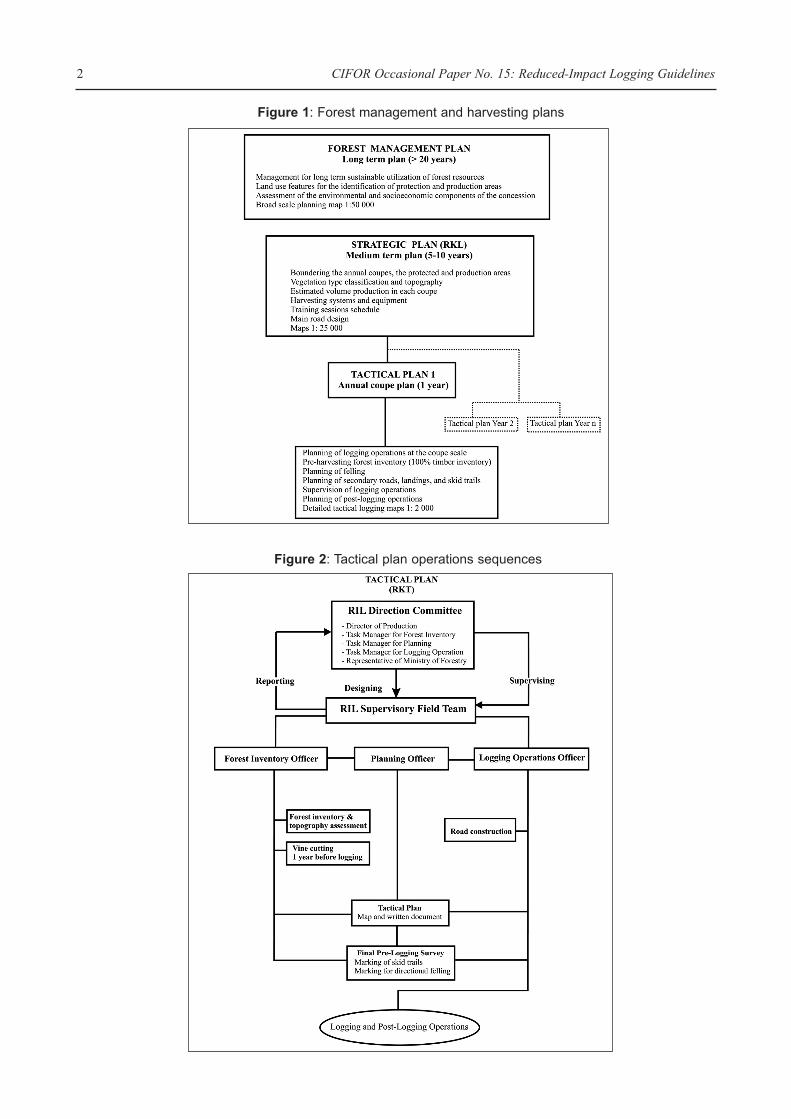
The success of RIL in significantly reducing loggingdamage on forest ecosystems cannot be achieved with-out the planning of harvesting operations. Harvestingplans must be included in a broader forest managementplan, which is a long term (> 20 years) land use plandesigned to ensure sustainable management of the for-est resource. The harvest planning process takes intoaccount the ecological, environmental, and socio-eco-nomic features of the concession, and are of two types:strategic (Figure 1) and tactical (Figure 2.)
1. 1. Strategic plan
Strategic harvesting plans are components of the forestmanagement planning process, and should be designedby an interdisciplinary planning team includingforesters, ecologists, logging specialists, engineers,wildlife biologists, and experts in social science.Strategic plans are medium term plans which, underTPTI regulations, are for a 5-year period and are calledRencana Kerja Lima tahun (RKL). In other countries,strategic plans may be for longer periods (10-20 years).The strategic plan provides the following informationin written documents and 1:25 000 scale maps:
Executive Summary
This report describes Reduced-Impact Logging (RIL) which will be implemented in the lowland and hill diptero-carp forests of the Bulungan Model Forest project in East Kalimantan, Indonesia. It is anticipated that throughthe implementation and supervision of the RIL practices described in this document, the timber concession oper-ators (INHUTANI II) can expect to: reduce disturbances to soil and residual vegetation by at least 50% in com-parison with conventional logging operations where these guidelines are not applied; limit overall direct impactsto the forest to < 25%; conserve wildlife and other forest resources, including non timber forest products (NTFPs),threatened and endangered species, keystone plant resources, and water; diminish direct logging costs by at least15%; and protect the long-term integrity and value of the permanent forest estate.
REDUCED-IMPACT LOGGING GUIDELINES FOR LOWLAND AND HILL DIPTEROCARP FORESTS
IN INDONESIA
Plinio Sist1, Dennis Dykstra2, and Robert Fimbel3
1 CIRAD-For�t/CIFOR. CIFOR P.O. Box 6596, JKPWB Jakarta 10065, Indonesia2 CIFOR, P.O. Box 6596, JKPWB Jakarta 10065, Indonesia.3 Wildlife Conservation Society (WCS) International Programs, 185th Street and Southern Blvd., Bronx, NY 10460 USA
CIFOR Occasional Paper No. 15: Reduced-Impact Logging Guidelines 2
Figure 1: Forest management and harvesting plans
Figure 2: Tactical plan operations sequences
Plinio Sist, Dennis Dykstra, and Robert Fimbel 3
¥ vegetation types of the area covered by the plan;¥ areas selected for timber harvesting and areas to be
excluded from silvicultural activities;¥ approximate boundaries and size of the annual
coupes; ¥ estimated standing and harvestable volume in each
coupe;¥ approximate road location for main transportation
routes; ¥ extraction techniques to be used; and¥ special conservation measures to be applied.
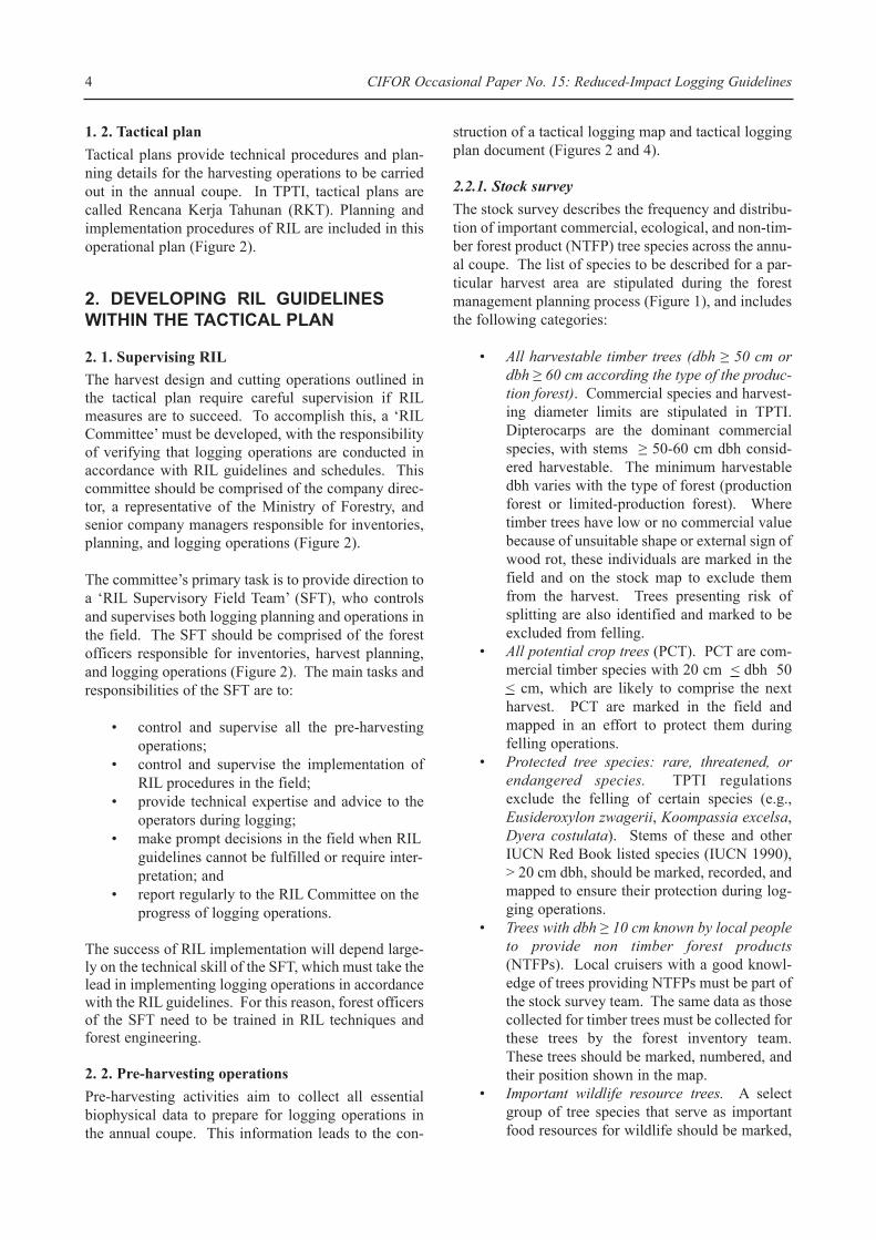
One important task of the strategic plan is to define thetype of extraction, which is primarily topographydependent.
¥ In areas where slopes are mostly <30% (see glos-sary), ground skidding is permitted.
¥ In coupes where the slopes mainly range from 30- 70%, ground skidding is prohibited because of the extensive damage to both soil and vegetation which results under these conditions. In this range of slopes, skyline yarding systems are an appropri-ate extraction system (Figure 3).
The decision to use cable extraction must be basedon a pre-harvesting plan, taking into account the
technical feasibility, the investment required, andthe commercial profitability. Cable systemsrequire special training and expertise to be suc-cessfully implemented, especially in Indonesiawhere cable extraction systems have rarely beenused (e.g., in the Sumalindo concession in EastKalimantan, Aulerich 1995). While many differentcable extraction systems are available to accom-modate different terrain conditions and foresttypes, skyline systems are considered to have thelowest impact on both soil and forest (Figure 3).This is particularly true when logs are fully sus-pended to eliminate soil disturbance. Thus, it isvery important that sufficient time is allotted to theplanning of these cable systems, so that the opera-tion can meet its environmental objectives at a rea-sonable cost. Finally, according to the terrain con-dition, extraction planning may suggest the use ofboth ground skidding and cable extraction in dif-ferent parts of a coupe.
¥ Areas with slopes > 70% must be excluded from cutting and should be identified as protection for- est. The same is true for riparian zones and areas of unique forest habitat.
Figure 3: Example of skyline with fully suspended logs
AU
LER
ICH
199
5
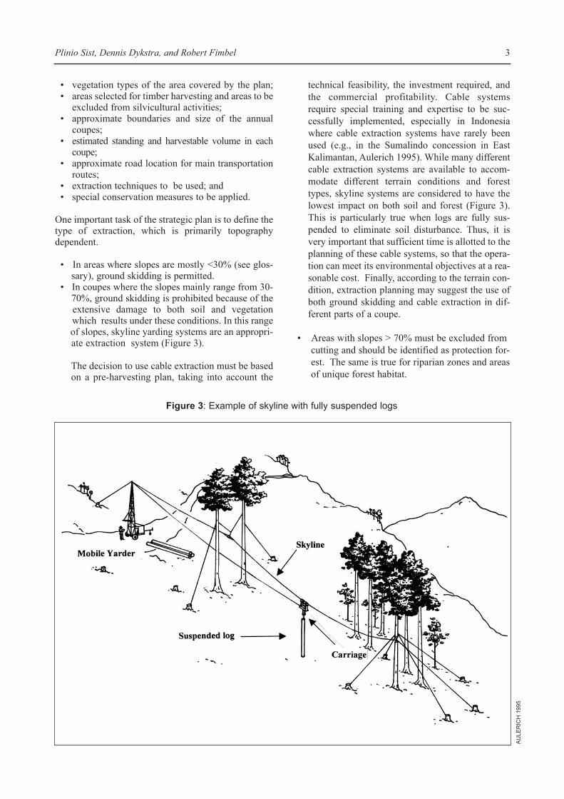
1. 2. Tactical plan
Tactical plans provide technical procedures and plan-ning details for the harvesting operations to be carriedout in the annual coupe. In TPTI, tactical plans arecalled Rencana Kerja Tahunan (RKT). Planning andimplementation procedures of RIL are included in thisoperational plan (Figure 2).
2. DEVELOPING RIL GUIDELINESWITHIN THE TACTICAL PLAN
2. 1. Supervising RIL
The harvest design and cutting operations outlined inthe tactical plan require careful supervision if RILmeasures are to succeed. To accomplish this, a ÔRILCommitteeÕ must be developed, with the responsibilityof verifying that logging operations are conducted inaccordance with RIL guidelines and schedules. Thiscommittee should be comprised of the company direc-tor, a representative of the Ministry of Forestry, andsenior company managers responsible for inventories,planning, and logging operations (Figure 2).
The committeeÕs primary task is to provide direction toa ÔRIL Supervisory Field TeamÕ (SFT), who controlsand supervises both logging planning and operations inthe field. The SFT should be comprised of the forestofficers responsible for inventories, harvest planning,and logging operations (Figure 2). The main tasks andresponsibilities of the SFT are to:
¥ control and supervise all the pre-harvesting operations;
¥ control and supervise the implementation ofRIL procedures in the field;
¥ provide technical expertise and advice to the operators during logging;
¥ make prompt decisions in the field when RILguidelines cannot be fulfilled or require inter-pretation; and
¥ report regularly to the RIL Committee on theprogress of logging operations.
The success of RIL implementation will depend large-ly on the technical skill of the SFT, which must take thelead in implementing logging operations in accordancewith the RIL guidelines. For this reason, forest officersof the SFT need to be trained in RIL techniques andforest engineering.
2. 2. Pre-harvesting operations
Pre-harvesting activities aim to collect all essentialbiophysical data to prepare for logging operations inthe annual coupe. This information leads to the con-
struction of a tactical logging map and tactical loggingplan document (Figures 2 and 4).
2.2.1. Stock survey
The stock survey describes the frequency and distribu-tion of important commercial, ecological, and non-tim-ber forest product (NTFP) tree species across the annu-al coupe. The list of species to be described for a par-ticular harvest area are stipulated during the forestmanagement planning process (Figure 1), and includesthe following categories:
¥ All harvestable timber trees (dbh ³ 50 cm ordbh ³ 60 cm according the type of the produc-tion forest). Commercial species and harvest-ing diameter limits are stipulated in TPTI.Dipterocarps are the dominant commercialspecies, with stems ³ 50-60 cm dbh consid-ered harvestable. The minimum harvestabledbh varies with the type of forest (productionforest or limited-production forest). Wheretimber trees have low or no commercial valuebecause of unsuitable shape or external sign ofwood rot, these individuals are marked in thefield and on the stock map to exclude themfrom the harvest. Trees presenting risk ofsplitting are also identified and marked to beexcluded from felling.
¥ All potential crop trees (PCT). PCT are com-mercial timber species with 20 cm < dbh 50< cm, which are likely to comprise the nextharvest. PCT are marked in the field andmapped in an effort to protect them duringfelling operations.
¥ Protected tree species: rare, threatened, orendangered species. TPTI regulationsexclude the felling of certain species (e.g.,Eusideroxylon zwagerii, Koompassia excelsa,Dyera costulata). Stems of these and otherIUCN Red Book listed species (IUCN 1990),> 20 cm dbh, should be marked, recorded, andmapped to ensure their protection during log-ging operations.
¥ Trees with dbh ³ 10 cm known by local peopleto provide non timber forest products(NTFPs). Local cruisers with a good knowl-edge of trees providing NTFPs must be part ofthe stock survey team. The same data as thosecollected for timber trees must be collected forthese trees by the forest inventory team.These trees should be marked, numbered, andtheir position shown in the map.
¥ Important wildlife resource trees. A selectgroup of tree species that serve as importantfood resources for wildlife should be marked,
CIFOR Occasional Paper No. 15: Reduced-Impact Logging Guidelines 4
recorded, and mapped to protect them duringthe harvest. The species to be included in thislist will be site specific (e.g., MacKinnon et al.1996, provide a table of important food treesfor wildlife and people in the forests ofKalimantan).
During the stocking survey, data to be recorded foreach tree included in the inventory are:
¥ tree number;¥ commercial or local name; ¥ position in the cutting block; and¥ estimated diameter class (in cm) above the
buttresses.
In order to be in line with TPTI forest inventory proce-dures, all harvestable trees (Group 1 above) will bemarked with red labels while PCT and protectedspecies will be marked with yellow labels. The labelsmust indicate the:
¥ annual coupe and cutting block (petak);
¥ number of the tree;¥ diameter class; and¥ commercial name.
In addition to this marking procedure required byIndonesian forest regulations, it is recommended thatmarks that can be easily identified in the forest be used.Therefore, harvestable trees should be marked with apainted red ring on the bark, while PCT and protectedspecies should receive a yellow ring.
Finally, the stock survey will be carried out at least 6months before logging by teams composed of bothforesters (for timber) and local cruisers (for NTFPs).Their activities will be supervised by the ForestInventory Officer of the SFT.
2. 2. 2. Climber cutting
Climbers can seriously compromise both feller safetyand directional felling. Therefore, all climbers > 2 cmdbh that are attached to the canopy of harvestable
Plinio Sist, Dennis Dykstra, and Robert Fimbel 5
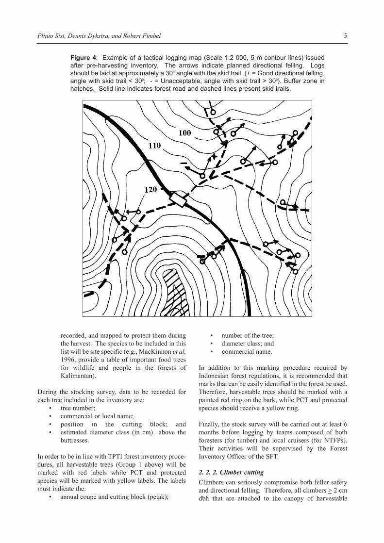
Figure 4: Example of a tactical logging map (Scale 1:2 000, 5 m contour lines) issuedafter pre-harvesting inventory. The arrows indicate planned directional felling. Logsshould be laid at approximately a 300 angle with the skid trail. (+ = Good directional felling,angle with skid trail < 300; - = Unacceptable, angle with skid trail > 300). Buffer zone inhatches. Solid line indicates forest road and dashed lines present skid trails.
stems should be cut at least 6 months before logging.Climber cutting should normally be done in conjunc-tion with the stock survey, and under the supervision ofthe Forest Inventory Officer of the SFT.
2. 2. 3.Topography assessment
Because the road and skidding trails network will bemainly designed and planned according to the terrain,it is essential to produce accurate topographic mapsusing all the modern methods and tools available (e.g.,aerial photos, satellite images, radar images).However, if the remote sensing images are not suffi-cient to produce maps at a suitable scale for loggingplanning (1:2000), topographic maps must be preparedby an intensive field survey (Klassen 1998). This isoften done in conjunction with the stock survey, wherethe maximum contour interval for a tactical loggingmap is 5 m, with contour intervals of 1 m or 2 m beingpreferred.
2. 2. 4. Protected areas
Within the cutting block, all areas are to be harvestedexcept those reserved as:
¥ Unworkable areas: areas that are too steep(> 30% for ground skidding and > 70% forany other logging system), rocky, and/or havevery low commercial timber.
¥ Sacred areas: areas that have cultural or reli-gious value for the local residents. Sacredareas must be defined in consultation withlocal populations and clearly marked as pro-tected areas on the logging plan maps.
¥ Conservation areas: areas that preserveunique and/or fragile habitats, and areas ofhigh biodiversity. These areas must be repre-sentative of the different ecosystems occurringin the concession and can only be definedthrough an assessment of the wildlife commu-nity and its habitat within the cutting block(Annex 1). Conservation areas may includeunworkable and sacred areas.
¥ Stream buffer zones: areas adjacent tostreams (permanent watercourses) where log-ging activities are not permitted. Streams areconsidered to be watercourses if they flow forat least 2 months in most years. Stream bufferzones vary in width from 20-200 m accordingto the size of the watercourse (Table 1).Stream buffer zones must be recorded duringthe topography assessment and drawn on thetactical plan maps.
All areas appearing to merit protection are noted dur-ing the stock survey and/or topography assessment,and subsequently delineated on the tactical plan maps.The following harvesting practices pertain to theseareas:
¥ No trees are to be felled within these protectedareas. Trees immediately outside these areasmust be felled in a direction away from theprotected areas.
¥ Machine access is normally prohibited inthese areas, but can be occasionally permitted,as necessary, by forest engineers in charge ofthe logging operation. Where permitted,access must cross by the shortest possible dis-tance.
¥ If a tree has been inadvertently felled into awatercourse, all debris must be removed with-out disturbance to the watercourse bank.
¥ No harvesting debris is to be pushed into areasexcluded from harvesting.
2. 2. 5. Road, landing, and skid trail planning2.2.5.1. Road design
Road planning aims to develop an optimal road net-work that minimises road density while providingaccess to all harvest areas. The location of the majorroads is specified as part of the strategic plan, whilesecondary roads are addressed in the tactical plan.Major road design may be modified and improved,
CIFOR Occasional Paper No. 15: Reduced-Impact Logging Guidelines 6
Table 1. Total width of stream buffer zones (SBZ) based on stream width
SBZ width in metresStream width between banks (width on both sides of the stream and from its centre)
< 1 m No buffer zone1-10 m 20 (10)11-20 m 50 (25)21-40 m 80 (40)> 40 m 200 (100)

however, following the pre-harvest topographic assess-ment carried out during tactical planning.
In RIL, forest roads must be constructed according toenvironmentally sound engineering practices to min-imise soil erosion and stream sedimentation. Althoughit is beyond the scope of this report to describe thesetechniques in detail, a few basic rules of environmen-tally sound forest road engineering warrant review (seeHaussman and Pruett 1978 for details on low-impactforest roads).
¥ Planning: proper road planning is essential toreduce road density and minimise soil distur-bance.
¥ Road width: although vegetation clearing isnecessary to allow sunlight to penetrate anddry the road after rainstorms, the general prin-ciple is that the width should be restricted to
the minimum that will permit a properly con-structed and maintained road on which haul-ing can be done efficiently and safely (Photos1 and 2). Experience has shown that properdrainage is much more important than sunlightin permitting roads to dry out quickly afterrainstorms.
¥ Cutting and filling: cutting and filling shouldbe minimised to reduce the exposure of baresoil and its potential to erode.
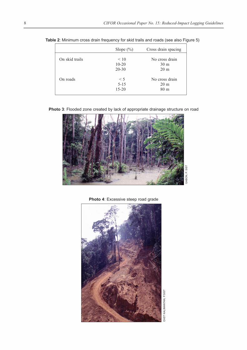
¥ Stream crossings: roads should be kept awayfrom streams and outside of streamside bufferzones. Where a stream crossing is necessary,a crossing structure must be designed and con-structed to minimise impacts on the stream and surrounding vegetation (Photo 3).
¥ Water diversions: roadside ditches and prop-erly spaced cross drains (Table 2) should be
Plinio Sist, Dennis Dykstra, and Robert Fimbel 7
Photo 2: Well constructed road with no excessive width
Photo 1: Excessive road width
SA
BA
H,
D.D
YK
ST
RA
GA
BO
N,
P.S
IST
CIFOR Occasional Paper No. 15: Reduced-Impact Logging Guidelines 8
Slope (%) Cross drain spacing
On skid trails < 10 No cross drain10-20 30 m20-30 20 m
On roads < 5 No cross drain5-15 20 m
15-20 80 m
Photo 3: Flooded zone created by lack of appropriate drainage structure on road
Table 2: Minimum cross drain frequency for skid trails and roads (see also Figure 5)
Photo 4: Excessive steep road grade
GA
BO
N,
P. S
IST
EA
ST
KA
LIM
AN
TAN
, P.
SIS
T
used and maintained to channel water away from the road structure and into the surround-ing vegetation.
¥ Road grade: the road grade should be as levelas possible, with a maximum grade of 10-20%(Photo 4). Sections of road where thegrade approaches 20% must not exceed 500 mlength.
¥ Access: controlling access is often the singlemost important step that forest managers cantake to protect the long term integrity of the for-est and the wildlife it contains (Fimbel et al. inpress). Thus, when developing an extractionroad network, planners should limit accessinto concessions to a few gated and patrolledentry points that keep individuals not directlyinvolved in the forest management activitiesout of the cutting area.
¥ Training: forest roads must be designed andlaid out in the field by skilled engineers.Training is therefore essential for the successof proper design and construction. Trainingsessions must be scheduled in the tacticalplanning as part of the logging operation planand supported financially by the concession-aire.
¥ Timing: roads must be constructed at least 3months before logging to permit them to ÔsetupÕ before intensive use begins.
2. 2. 5. 2. Landings
Landing density and surface area can be limited byplanning roads and landings prior to logging, drawingon topographic information and harvestable volumesgenerated in the stock survey and/or topographyassessment. To minimise the environmental impactsassociated with landings (or temporary log storageareas), the following practices should be executedunder the supervision of the SFT Planning Officer:
¥ develop landings adjacent to roadways; ¥ restrict their size to < 0.2 ha (approximately
30x60 m);¥ avoid placing landings in areas excluded from
harvesting; and¥ locate landings on ridges to ensure uphill skid-
ding and good drainage of the site.
2. 2. 5. 3. Planning the skid trail network
Skid trails are planned following an analysis of the treeposition and topography data provided by the stocksurveys and topography assessment. Recording thedata in a GIS database will be undoubtedly an advan-tage for any data analysis and interpretation. Dataanalysis and skid trail network planning is the respon-
sibility of the Planning Officer of the SFT. The ForestInventory Officer and Logging Operation Officershould also be consulted for technical advice and assis-tance. The following rules serve as the foundation ofany skid trail design (Figure 4):
¥ Ground skidding is not allowed on slopesgreater than 30%, nor in protected areas orstream buffer zones.
¥ Stream crossings are not allowed. Where theycannot be avoided, crossing points must beclearly shown on the map and must beapproved after a field inspection by thePlanning or Forest Inventory Officer of theSFT.
¥ The skid trail network must be optimisedaccording to the position and density of treesto be felled to minimise the length of trails inthe forest.
2. 2. 5. 4. Planning for felling
The major objective of directional felling is to lay logsin position to facilitate extraction. Another aim is toavoid damage to trees that are expected to form part ofthe timber crop in the next felling cycle (i.e., commer-cial trees with dbh ³ 40 cm), to stems that warrant aprotected status, and to other residual vegetation.Directional felling should be used to protect thesetrees, which have been identified and recorded duringthe stock survey. Planning for directional felling is theresponsibility of the Planning Officer of the SFT. Themain guidelines for planning directional felling are:
¥ The tree must be felled either toward or awayfrom skid trails or cableways at an obliqueangle of approximately 300 to the skiddingdirection, unless the tree can be felled directlyonto the skid trail (Figure 4).
¥ Where possible, trees should be felled in thedirection of existing canopy gaps.
¥ On steep slopes, trees must be felled uphillunless their downhill lean is so great thatdirectional felling techniques are unable topull the tree uphill.
¥ Trees adjacent to a stream buffer zone must befelled so that their crowns fall outside thebuffer zone.
¥ Proper felling procedures must be applied inorder to avoid splitting of the tree duringfelling.
Finally, recent studies have demonstrated that the capa-bility of RIL techniques to reduce damage to the resid-ual vegetation by 50%, compared to conventional har-vesting practices, cannot be achieved if the felling
Plinio Sist, Dennis Dykstra, and Robert Fimbel 9
intensity is > 8 trees/ha (Bertault and Sist 1995, 1997;Sist et al. 1998). In other locations, where silvicultur-al objectives may vary from those in the TPTI selectivesystem, the maximum number of trees/ha to cut and theeffectiveness of RIL techniques to reduce loggingimpacts compared to conventional logging practiceswill need to be assessed. Decisions to exclude timber-size trees from harvesting are the responsibility of theSFT and are based on the data provided by the stocksurvey. In areas with high timber density, very bigtrees, such as emergent trees, might be excluded fromharvest and retained as seed bearers.
2. 2. 6. Final pre-logging RIL survey
Before the logging operation begins, it is necessary tocarry out a final pre-logging survey, which will involvethe following activities:
¥ marking the skid trail network in the field byopening wide (2 m) and visible trails in theforest (use of coloured ribbons or paintedmarks on trees is recommended); the openingof skid trails before felling operation can bealso considered as an alternative option, withthe main advantage of helping fellers andsupervisors in the field when they must checkthe best feasible direction of felling of eachtree;
¥ checking in the field to determine if the fellingdirections planned on the map according tothe skid trail network and topography are fea-sible. Before felling, RIL supervisors will goto the field, with the feller to check the natur-al leaning of the tree which will define the1800 felling sector;
¥ marking the final felling direction by paintinga mark on the bole of the tree; and
¥ marking trees to be excluded from harvestingin areas where the number of harvestable tim-ber trees is >8 trees/ha (repainting stem ringyellow).
2. 2. 7. Tactical maps and written plans
Pre-harvesting inventories and planning must con-tribute to the development of a tactical map whichincludes all the information needed to achieve the log-ging operations as defined in the plan. The tacticalmap must be at a scale of 1:2 000 and display the fol-lowing information (Figure 4):
¥ topographic contour lines (5 m interval orless);
¥ position of each tree to be felled, marked withits inventory number;
¥ direction of felling for each tree;
¥ road network and landing locations;¥ skid trail network; and¥ stream buffer zones and other exclusion areas.
The tactical plan must also include a written documentgiving all the technical details on each activity to becarried out (pre-harvesting, harvesting, and post-har-vesting).
3. HARVESTING OPERATIONS
3. 1. Felling (team, maps, and material)
Fellers must use the detailed tactical logging map toplan their work. Efficiency of the felling operation canbe improved if fellers review the topography and treeposition information included in the tactical loggingmap in advance of each working day. This will helpthem to decide the sequence of trees to be felled duringthe day.
Felling operations must be carried out by skilled per-sonnel outfitted with appropriate safety gear and usingproperly maintained equipment. The fellers must befamiliar with directional felling techniques, and thelogging company must provide training to the fellerswho have no former experience in these techniques.Any decision to fell a tree in a different direction otherthan the one foreseen in the pre-harvesting plan mustbe recorded and reported to the SFT Planning Officer.
3. 2. Skid trail marking and opening
During log extraction the following practices andequipment are recommended:
¥ Skid trails must be opened according to theplanning skid trail network shown in the tacti-cal logging map and in the forest. For this,skidder operators must bring the map to thefield and follow the network design.
¥ Skid trail width must not exceed 4 m.¥ Skidder operators are not permitted to leave
the marked skid trails without permission ofthe SFT Logging Operation Officer.
¥ Skid trails are not allowed to cross streamswider than 5 m or gullies. Where this must bedone, crossing must be made at a site wherethere is a rock base and the stream bed must beprotected with logs or a temporarily culvert.The site of the stream crossing must beapproved in advance by the SFT LoggingOperation Officer.
¥ Wheeled skidders or crawler skidders (Figures5A and 5B) should be used in preference tocrawler tractors (Figure 5C), given their
CIFOR Occasional Paper No. 15: Reduced-Impact Logging Guidelines 10
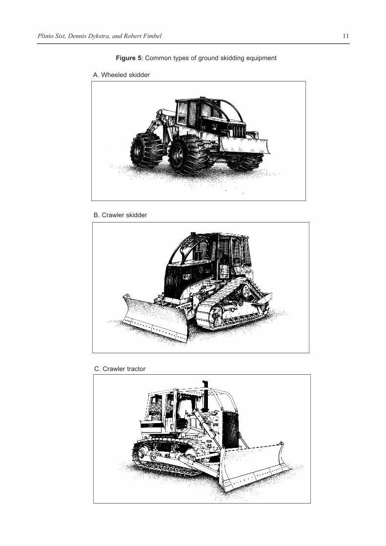
Plinio Sist, Dennis Dykstra, and Robert Fimbel 11
C. Crawler tractor
B. Crawler skidder
A. Wheeled skidder
Figure 5: Common types of ground skidding equipment
CIFOR Occasional Paper No. 15: Reduced-Impact Logging Guidelines 12
smaller size and greater manoeuvrability inthe forest (i.e., less likelihood of causing dam-age to residual stems and soils). The largercrawler tractors should only be used in roadconstruction and maintenance.
¥ The skidder must have a power winch with atleast 30 m of wire rope as well as an arch or other support that will suspend the end of the load off the ground to prevent logs from dig-ging into the soil as they are being skidded.
¥ The blade of the skidder should not exceed 3mand blading should be avoided as much aspossible in order to minimise the impact onsoil (Photos 7 and 8).
¥ Skidding of logs behind the tractor is notallowed on slopes > 30%; on such slopes,logs must be pulled up the hill using the powerwinch.
¥ Blading and log extraction during rainy daysmust be avoided in order to limit soil erosionand compaction.
3. 3. Salary system
RIL techniques require the employment of skilled,well trained, and responsible staff, and a modifiedpiecework remuneration system in which the paymentscheme takes into account the quality of the work. The
remuneration system used in conventional logging,which only takes into account the commercial volumeproduced, is not effective in motivating the applicationof RIL techniques. A compensation system thatrewards workers for good practices, and penalizesthem for sloppy work, is needed.
4. POST-HARVESTING OPERATIONS
4. 1. Rehabilitation of skid trails
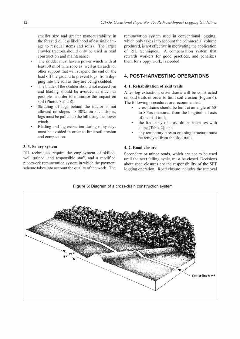
After log extraction, cross drains will be constructedon skid trails in order to limit soil erosion (Figure 6).The following procedures are recommended:
¥ cross drains should be built at an angle of 600
to 800 as measured from the longitudinal axisof the skid trail;
¥ the frequency of cross drains increases withslope (Table 2); and
¥ any temporary stream crossing structure mustbe removed from the skid trails.
4. 2. Road closure
Secondary or minor roads, which are not to be useduntil the next felling cycle, must be closed. Decisionsabout road closures are the responsibility of the SFTlogging operation. Road closure includes the removal
Figure 6: Diagram of a cross-drain construction system
of log culverts and temporary bridges as well the con-struction of cross drains according to the guidelineslisted in Table 2.
4. 3. Other post-harvesting operationsOther important post-harvesting operations include:
¥ Controlled access to the permanent forestestate. Only those individuals directlyinvolved with forestry operations should bepermitted in the permanent forest estate. Apossible exception would be to allow localstakeholders access. However, they wouldneed to register their activities with the forestofficer. Only ephemeral, subsistence activi-ties would be allowed.
¥ Proper maintenance of road surfaces, roadsideditches, cross drains, and stream crossings.Secondary or minor roads can be closed off ifthey will not be used again until the nextfelling cycle.
¥ Clean landings and temporary camps. Barkand other vegetal debris are to be burnt, andrubbish, including oil or fuel, drums, and wirerope, are to be removed. Cans and othermetallic waste are to be buried.
CONCLUSIONS AND DISCUSSION
Through the implementation and supervision of theRIL practices described in this document, timberconcession operators can expect to:
¥ reduce disturbances to soil and residual vege-tation by at least 50% in comparison with con-ventional logging operations where theseguidelines are not applied;
¥ conserve wildlife and other forest resources,including NTFPs, threatened and endangeredspecies, keystone plant resources, and water;
¥ diminish direct logging costs by at least 15%;¥ protect the long term integrity and value of the
permanent forest estate; and limit overall directimpacts to the forest to < 25 %.
Recent studies in Indonesia suggested that damageaffecting 25% of the original stands could be a reason-able threshold for sustainability (Bertault and Sist1995, 1997; Sist et al. in press). Sustainable forestmanagement, of which RIL is one component, is essen-tial for the long term health and productivity of forests.RIL in itself is a technical procedure to reduce theenvironmental impacts associated with timber harvest-ing operations, and not a single activity that willachieve sustainable forest management.
Avoidance of enrichment planting is likely to be animportant economic incentive for concessionaires toapply RIL on a concession scale. Forests harvestedwith RIL appear to regenerate faster and with a higherpercentage of commercial species compared to thoselogged under conventional practices (Sist, unpublisheddata), suggesting that residual stands following RILwill be better able to sustain repetitive felling cycles.Research efforts at the Bulungan Research Forest,combined with similar studies being initiated and mon-itored by CIFOR, CIRAD-For�t, the WildlifeConservation Society, and other forestry research insti-tutions, should help to clarify the ecological and eco-nomic gains of RIL compared to conventional timberharvesting practices.
Finally, it will be necessary to assess the performanceof concessionaires in following the technical guide-lines of RIL. This could be conducted by independentinterdisciplinary audit teams including foresters, ecol-ogists, logging specialists, forest engineers, econo-mists, wildlife biologists, and experts in social science.Certification groups, or non-governmental conserva-tion organisations, might conduct these independentevaluations. Based on the research carried out byCIFOR on RIL and sustainable forest management(Prabhu et al. 1996), it would be possible to define aset of criteria and indicators which could be used forthe assessment of the concessionaireÕs performance inthe application of these logging techniques.
Plinio Sist, Dennis Dykstra, and Robert Fimbel 13
LITERATURE CITED
Armitage, I. and Kuswanda, M. 1989. Forest management for sustainable production and conservation inIndonesia. UTF/INS/065: INS Forestry Studies. Field Document No. 1-2. Directorate General of Forest Utilisation,Ministry of Forestry, Government of Indonesia, FAO, Jakarta, Indonesia. 266 p.
Aulerich, E. 1995. Applying skylines to partial-cuts in the tropics. Asian Timber, November, 41-44.
Bertault, J-G. and Sist, P. 1995. The effect of logging in natural forests. Bois et For�ts des Tropiques 245: 5-20.
Bertault, J-G. and Sist, P. 1997. An experimental comparison of different harvesting intensities with reduced-impact and conventional logging in East Kalimantan, Indonesia. Forest Ecology and Management 94: 209-18.
Dykstra, D. and Heinrich, R. 1996. FAO model code of forest harvesting practice. FAO, Rome. 85 p.
Ek, R.C. 1997. Botanical diversity in the tropical rain forest of Guyana. Tropenbos Ð Guyana Series 4. Tropenbos,Georgetown, Guyana. 237 p.
Fimbel, R.A., Grajal, A. and Robinson, J.G. (eds.). In press. Conserving Wildlife in Managed Tropical Forests.Columbia University Press, New York, USA.
Haussman, R.F. and Pruett, E.W. 1978. Permanent logging roads for better woodlot management. USDA ForestService Publication NA-FR-18.
IUCN. 1990. IUCN red list of threatened animals of the world. IUCN, Gland, Switzerland.
Klassen A.W. 1998. Procedures for topographic forest surveys. Miscellaneous Report. CIFOR, Bogor, Indonesia.20 p.
Larrea, M. 1997. Respuesta de las ep�fitas vascualares a diferentes formas de manejo del bosque nublado, BosqueProtegido SierrAzul, zona de amortiguamiento de la Reserva Ecol�gica Cayambe-Coca, Napo, Ecuador. In Mena,P.A., Soldi, A., Alarc�n, R., Chiriboga, C. and Su�rez, L. (eds.) Estudios biol�gicos para la conservaci�n.Diversida, ecolog�a y etnobiolog�a, 321-46. EcoCiencia, Quito, Ecuador.
MacKinnon, K., Hatta, G., Halim, H. and Mangalir, A. 1996. The Ecology of Kalimantan. Periplus Editions Ltd.,Hong Kong. 802 p.
Prabhu, R., Colfer, C.J.P., Venkateswarlu, P., Tan, L.C., Soekmadi, R. and E. Wollenberg. 1996. Testing criteriaand indicators for the sustainable management of forests. Phase I final report. CIFOR, Bogor, Indonesia.
Pinard, M. and Putz, F.E. 1996. Retaining forest biomass by reducing logging damage. Biotropica 28: 278-95.
Pinard, M.A., Putz, F.E., Tay, J. and Sullivan, T.E. 1995. Creating timber harvesting guidelines for a reduced-impact logging project in Malaysia. Journal of Forestry 93(10): 41-5.
Sayer, J.A. and Wegge, P. 1992. Biological conservation issues in forest management. In J.M. Blockhus et al.(eds.). Conserving biological diversity in managed tropical forests. 1-12. Proceedings of an IUCN workshop,Perth, Australia, 30 November-1 December 1990. IUCN/ITTO.
Sist, P. 1997. ITTO funds for Bulungan Research Forest. CIFOR News 15(June): 3.
Sist, P., Nolan, T., Bertault, J-G., Dykstra, D. 1998. Harvesting intensity versus sustainability. Forest Ecology andManagement, 108: 251-60.
Wollenberg, E. and Sist, P. 1997. The Bulungan Research Forest. CIFOR 1996 annual report, 10-11. CIFOR,Bogor, Indonesia.
WCS. 1998. Program to inventory and monitor the response of select plants and animals within production for-est areas of communities participating within SUBIR Phase III. Miscellaneous Report. Wildlife ConservationSociety, New York, USA. 46 p.
CIFOR Occasional Paper No. 15: Reduced-Impact Logging Guidelines 14
Plinio Sist, Dennis Dykstra, and Robert Fimbel 15
ANNEX 1: Field assessment guidelines for conservation area designation withinthe strategic plan and tactical planning processes (after WCS 1998)
Habitat characteristics
Principles Habitat characteristics are used as indirect measures of wildlife populations and the biological diversity compris-ing an area of forest. They seek to identify unique or sensitive habitats that may warrant protection from harvest-ing practices. Habitats are evaluated within a portion of the area covered by the stocking survey, using belt tran-sects or fixed dimension plots (depending upon the experience of the inventory crews), systematically covering 2-3% of the stocking survey area. Characteristics of the forest that are assessed include:
¥ coarse woody debris (standing);¥ coarse woody debris (down);¥ canopy closure;¥ vertical vegetation structure;¥ keystone resources; and¥ soil litter and decomposition gradient.
Sampling designThe sampling vegetation plot is 0.1 ha (20x50 m). This size is provided for purposes of this example, as 0.1 havegetation plots are widely used by foresters and ecologists in the tropics. Other plot configurations may be moreappropriate under different tactical planning procedures.
Coarse woody debris (standing)All dead standing stems > 20 cm dbh within the 0.1 ha plot are measured. Measurements include dbh in 10 cmdiameter classes, and an assessment of the stage of stem decay (see four classes below).
(a) Standing decay class 1: standing dead, wood hard, bark on, small branches and/or twigs (< 1 cm diam- eter) often present.
(b) Standing decay class 2: standing dead, wood soft outside (i.e., 1-2 cm of knife blade easily embed-ded), bark and branches usually absent.
(c) Standing decay class 3: standing dead, wood soft throughout (i.e., majority of knife easily embedded),bark usually off, structural integrity remaining.
(d) Standing decay class 4: collapsed stem or collapsible under slight pressure, bark usually off (wherecollapsed to < 1.3 m tall it is classified under ÔgroundÕ coarse woody debris, see below).
Coarse woody debris (ground)All dead fallen stems and limbs > 20 cm dbh within the 0.1 ha plot are measured. To determine the volume of thismaterial, diameters for each piece of fallen material are measured to the nearest 5 cm, at both the small and largeends of the piece, or the point at which the material crosses the plot boundary. The total length of the material ismeasured to the nearest 10 cm. In addition, the fallen material is classified into one of the following four decaystages:
(a) Ground decay class 1: wood hard, bark on, small branches and/or twigs (< 1 cm diameter) may stillbe present.
(b) Ground decay class 2: wood soft outside (i.e., 1-2 cm of knife blade easily embedded), bark on or off.
(c) Ground decay class 3: wood soft throughout (i.e., majority of knife blade easily embedded), bark usually off, structural integrity remaining.
(d) Ground decay class 4: log/stump collapsed under own weight, or collapsible by slight pressure of foot, bark usually off.
Canopy closureThe percentage canopy closure is measured at three points within the 0.1 ha plot: the starting edge of the plot (0 m),the mid-point of the plot (25 m), and the ending edge of the plot (50 m). Measurements are taken at a height of1.3 m and ground level using a spherical densiometer. Simple instructions are included with this device.
Vertical vegetation structureCanopy cover is measured at 50 points criss-crossing each plot. Beginning at the mid-point of the 0.1 ha plot, andradiating 13 m out parallel and perpendicular to the plot centreline, point-quadrat canopy intercept measurementsare taken at 1 m intervals. Vertical to each point (using a SUUNTO clinometer or GRS densitometer), any foliageintercepted within the four designed height classes (0-2, 2-10, 10-20, 20+ m tall) will be recorded with a Ô1Õ. Anabsence of any foliage intercept within a given height class will be indicated by an Ô0Õ. Percentage canopy coverfor each height strata within a plot is calculated by multiplying the number of foliage encounters in a height class(Ô1Õs) by two.
Keystone resourcesKeystone resources are species, or groups of species, that play a pivotal role in ecosystem processes and uponwhich a large part of the community depends. Ficus spp. are often perceived as keystone resources in the tropics,given their continuous, aseasonal fruiting. Other keystone plant species may exist within the Tactical Plan area(see MacKinnon et al. 1996:431 for an example of important wildlife food trees), and should be considered forinclusion in the inventory process upon their identification.
Soil litter Depth and gradient of leaf litter decomposition are measured at two random points within the 0.1 ha plot. Usinga metric Biltmore stick, the depth of litter to the nearest mm is recorded at 20 cm intervals along the stick (sixpoints). In addition, the gradient of leaf litter decomposition (from least broken down material at the top of the lit-ter layer to most decomposed at the bottom), is noted at either end of the Biltmore stick. Three decompositionclasses are used.
(a) Decomposition class 1: Uniform gradient from non-decomposed leaves to soil organic matter.(b) Decomposition class 2: Non-decomposed leaves resting on bare mineral soil.(c) Decomposition class 3: No soil litter.
Rapid assessment of wildlife
In the current inventory design, no animal groups are directly measured with the exception of those listed in theIUCN Red Book (IUCN 1990). Sampling procedures will depend on the individual species and their ecology (tobe determined following a review of known threatened and endangered wildlife that might occur within theTactical Plan area). Additional faunal groups, other than those threatened or endangered, might be recommendedfor inclusion in future inventories, as results are examined from the planned biodiversity impact assessment in theBulungan Model Forest study (Sist 1997). If valuable ecological information can be collected on select animalgroups in a timely fashion, these groups may be included in future pre-harvest inventories.
Animal signs (tracks, dung, diggings, feeding remains, trails, etc.) should be evaluated along transects. The tran-sects are walked at an average speed of 1 km/hr by a local hunter. When a sign is observed from the transect (theobserver stays on the transect and does not wander about the forest), it is described, and its location along the tran-sect noted (transects should appear on maps). Finally, the quality of the data is completely dependent on the detec-tion and identification skills of the observer. Therefore, to the extent possible, the same observer(s) is (are) usedfor all observations pertaining to animal signs across a cutting block.
Conservation area designation
Based upon the findings of the habitat and animal assessments, areas of forest supporting unique structural or com-positional characteristics should be considered for protection. In addition, a small portion of common habitat typesshould be reserved from cutting, in an effort to protect the full range of habitat types occurring within the managedforest. In general, important areas for protection within the production forest landscape include those supporting:
16 CIFOR Occasional Paper No. 15: Reduced-Impact Logging Guidelines

¥ populations of rare and endangered species;¥ high concentrations of endemic species and/or exceptional species richness;¥ unusual vegetation habitats, landforms, geology, or other physical features not represented in other
protected areas; and¥ areas serving as corridors between reserves, especially riparian zones (Sayer and Wegge 1992).
17Plinio Sist, Dennis Dykstra, and Robert Fimbel

ANNEX 2: Glossary
Annual coupe: Area of forest to be harvested within a period of one year. In Indonesia, it is called Rencana KerjaTahun(RKT) and usually starts in March.
Bucking: The act or process of transversely cutting the stem of a felled tree into logs.
Buffer zone: Area from which all harvesting equipment and operations are excluded. Buffer zones are usuallyalong streams.
Cable : A flexible steel rope made up of numerous wire stands that are twisted helically together around a core ofwire, wire rope, fibre, plastic, or other material.
Cable yarding system: Any of a variety of terrain support systems in which suspended cables are used to conveylogs to the landings.
Cableway: The pathway along which logs are yarded with a cable yarding system.
Climbers: Vines that either hang freely, are suspended from the forest canopy, or adhere to the stems of trees.Climbers with woody stems are often called lianas.
Contour lines: lines drawn on a map which link points of the same elevation.
Cutting block: The annual coupe is usually divided into compartments of equal size. In Indonesia each of thesecompartments is called petak and covers about 100 ha.
Dbh: Diameter at breast height. The diameter of a tree measured at a standard reference height, usually 1.3 mabove ground level.
Extraction: The process of transporting logs from the felling site to a landing.
Felling: The act or process of severing a standing tree.
Felling cycle: The planned, recurring number of years between successive harvests on a specific, physical area ofland. It is also called harvesting cycle.
Ground skidding: See Skidding.
Harvesting: The aggregation of all operations, including pre-harvest planning and post-harvest assessment, relat-ed to the felling of trees and the extraction of their stems or other useable parts from the forest for subsequent pro-cessing into industrial products.
Landing: A cleared area where logs are collected during extraction in preparation for transport to the processingfacility or other final destination.
Limbing: The act or process of severing the branches from the stem of a felled tree.
Log: Any section of the bole of a felled tree after limbing and bucking.
Logging: The act or process of felling and extracting timber from forests, especially in the form of logs.
Non timber forest products (NTFPs): All biological material, other than industrial roundwood, that may beextracted from the forest, either for commercial purposes, for use within the household, or for social, cultural orreligious uses. Also referred to as non wood forest products (NWFPs).
18 CIFOR Occasional Paper No. 15: Reduced-Impact Logging Guidelines

Production forests and limited production forests: Forests defined for selective logging under TPTI regulation.The diameter limit for production forest is 50 cm, while in limited production forests the diameter limit is 60 cm.
Skidding: Terrain transport in which logs are dragged to the landings, rather than suspended in the air or carriedon a vehicle. Also referred to as ground skidding.
Skid trail: The pathway over which logs are skidded in a ground skidding extraction system.
Skyline yarding system: A cable yarding system that makes use of a heavy wire rope (the skyline) that is stretchedbetween two spar trees and used as a track for a skyline carriage (a wheeled device riding along the skyline andcarrying logs).
Slope: The slope in % is defined as follows:
Stump: The woody base of a tree that remains in the ground after felling.
Timber: Trees suitable for conversion into industrial forest products.
19Plinio Sist, Dennis Dykstra, and Robert Fimbel
Slope
Horizontal Distance
VerticalDistanceVertical Distance x 100 = Slope %
Horizontal Distance


![AJPS 17:2 (2014), pp. 171-186] HEALING IN THE LOWLAND ... · religious practices among lowland Filipinos, this research can be broadly used throughout the lowland cultures. Since](https://img.pdfslide.us/doc/110x75/5e28aaca5b3b5737b60974b2/ajps-172-2014-pp-171-186-healing-in-the-lowland-religious-practices-among.jpg)