Embed Size (px)
Citation preview
Record of Decisionfor
I-25 Improvements Through Pueblo
Final Environmental Impact Statement and Section 4(f) Evaluation
Colorado Department of Transportation
Region 2
and
Federal Highway Administration
CDOT Project No. IM 0251-156Project Control No. 12831
March 2014
FHWA Check Copy Draft
i
STATUTE OF LIMITATIONS
The Federal Highway Administration (FHWA) may publish a notice in the Federal Register, pursuant to 23 United States Code
§ 139(1), once the Record of Decision (ROD) is approved. If such notice is published, a claim arising under federal law seeking
judicial review of a permit, license, or approval issued by a federal agency for a highway or public transportation capital project shall
be barred unless it is filed within 150 days after publication of a notice in the Federal Register announcing that the permit, license,
or approval is final pursuant to the law under which judicial review is allowed. If no notice is published, then the periods of time that
otherwise are provided by the federal laws governing such claims will apply.
INFORMATION AVAILABILITY
The following individuals may be contacted for further information regarding this ROD:
Joe DeHeart
Project Manager
Colorado Department of Transportation, Region 2
905 Erie Avenue
Pueblo, Colorado 81001
(719) 546-5439
Chris Horn
Senior Operations Engineer/Right-of-Way Program Manager
Federal Highway Administration
12300 W. Dakota Avenue, Suite 180
Lakewood, Colorado 80228
(720) 963-3017
FINAL ENVIRONMENTAL IMPACT STATEMENT AVAILABILITY
The I-25 Improvements Through Pueblo Final Environmental Impact Statement and Final Section 4(f) Evaluation (Colorado
Department of Transportation [CDOT] and FHWA, 2013) (FEIS) is available for review at http://www.coloradodot.info/projects/ and
at the following locations:
Federal and State Offices - CDOT Headquarters (Public Relations Office) - Bob Wilson, Public Relations Manager, Region 2, 4201 East Arkansas
Avenue, Denver, Colorado 80222 - CDOT Region 2 (Pueblo) - Joe DeHeart, Project Manager, 905 Erie Avenue, Pueblo, Colorado 81002 - Federal Highway Administration, Colorado Division Office, 12300 West Dakota Avenue #180, Lakewood, Colorado 80228
Libraries - Colorado State University Pueblo Library, 2200 Bonforte, Pueblo, Colorado 81001 - Pueblo Community College Library, 900 West Orman Avenue, Pueblo, Colorado 81004 - Pueblo Library – Barkman Branch, 1300 Jerry Murphy Road, Pueblo, Colorado 81004 - Pueblo Library – Pueblo West Branch, 298 South Joe Martinez Boulevard, Pueblo, Colorado 81005 - Pueblo Library – Rawlings Branch, 100 East Abriendo Avenue, Pueblo, Colorado 81004 - Pueblo Library at the Y, 3200 Spaulding, Pueblo, Colorado 81008
Please contact Joe Deheart, CDOT project manager (listed above) to obtain a copy of the FEIS.
I-25 NEW PUEBLO FREEWAY RECORD OF DECISION
ii
TABLE OF CONTENTS
1.0 Introduction ....................................................................................................................................................................... 1-1
1.1 Background ........................................................................................................................................................... 1-1
1.2 Purpose and Need ................................................................................................................................................ 1-1
2.0 Identification of the Preferred Alternative....................................................................................................................... 2-1
2.1 Development and Screening of Alternatives ......................................................................................................... 2-1
2.1.1 Final Detailed Alternatives ...................................................................................................................... 2-1
2.2 Basis for Identification of the Preferred Alternative ............................................................................................... 2-6
2.2.1 How the Preferred Alternative Addresses the Elements of the Purpose and Need ................................ 2-6
2.2.2 Other Contributing Factors ..................................................................................................................... 2-7
2.3 Environmentally Preferable Alternative ............................................................................................................... 2-16
2.4 Least Environmentally Damaging Practicable Alternative .................................................................................. 2-17
3.0 Phase 1 of the Preferred Alternative ............................................................................................................................... 3-1
3.1 Project Funding Scenario ..................................................................................................................................... 3-1
3.2 Description of Phase 1 Improvements .................................................................................................................. 3-1
3.3 Timing of Future Phases ....................................................................................................................................... 3-3
3.4 Responsiveness to Purpose and Need ................................................................................................................. 3-5
3.5 Phase 1 Environmental Impacts ........................................................................................................................... 3-6
4.0 Section 4(f) ........................................................................................................................................................................ 4-1
4.1 Introduction ........................................................................................................................................................... 4-1
4.2 Section 4(f) Properties .......................................................................................................................................... 4-1
4.3 All Possible Planning to Minimize Harm ............................................................................................................... 4-3
4.4 Consultation and Coordination.............................................................................................................................. 4-3
5.0 Clarifications to the FEIS and Updates in Regulations ................................................................................................. 5-1
5.1 Clarifications and Corrections to the FEIS ............................................................................................................ 5-1
5.1.1 Clarifications and Corrections Related to Park and Recreational Resources ......................................... 5-1
5.1.2 Clarifications and Corrections Related to Environmental Justice ........................................................... 5-1
5.1.3 Clarifications and Corrections Related to Noise ..................................................................................... 5-2
5.1.4 Clarifications and Corrections Related to Mitigation Commitments ........................................................ 5-2
5.2 Noise Preference Surveys .................................................................................................................................... 5-4
5.3 Unresolved Issues from the FEIS ......................................................................................................................... 5-6
6.0 Public Comments Received on the FEIS ........................................................................................................................ 6-1
6.1 Summary of Comments Received on the FEIS .................................................................................................... 6-1
7.0 Federal, State, and Local Permits and Approvals .......................................................................................................... 7-1
7.1 Air Quality ............................................................................................................................................................. 7-1
7.1.1 Project Level Air Quality Conformity for Phase 1 of the Preferred Alternative ........................................ 7-1
7.1.2 Regional Air Quality Evaluation for the Preferred Alternative ................................................................. 7-1
7.1.3 Regional Air Quality Conformity for Phase 1 of the Preferred Alternative .............................................. 7-1
7.2 Section 106 Consultation ...................................................................................................................................... 7-1
7.3 Section 6(f) of the Land and Water Conservation Fund Act.................................................................................. 7-1
7.4 CDOT 1601 Process ............................................................................................................................................. 7-2
7.5 Section 404 Permit ............................................................................................................................................... 7-3
7.6 Biological Opinion ................................................................................................................................................. 7-3
TABLE OF CONTENTS (CONTINUED)
I-25 NEW PUEBLO FREEWAY RECORD OF DECISION
iii
7.7 Senate Bill 40 Certification .................................................................................................................................... 7-3
7.8 Floodplain Permit .................................................................................................................................................. 7-4
7.9 Monitoring and Enforcement ................................................................................................................................. 7-4
8.0 Mitigation ........................................................................................................................................................................... 8-1
9.0 Record of Decision ............................................................................................................................................................ 9-1
10.0 References ....................................................................................................................................................................... 10-1
Appendix A – Figures of Preferred Alternative and Phase 1
Appendix B – Response to Public and Agency Comments on the FEIS
Appendix C – Public Involvement Materials
Appendix D – Agency Correspondence
Appendix E – Section 106 Programmatic Agreement
Appendix F – I-25 Bridge Over the Arkansas River
List of Exhibits
2-1 No Action Alternative
2-2 Existing I-25 Alternative
2-3 Modified I-25 Alternative (Preferred Alternative)
2-4 Comparison of Direct and Indirect Impacts from the Alternatives Considered in the FEIS
3-1 Five Projects Proposed for Phase 1 of the Preferred Alternative
3-2 Preferred Alternative Project Phasing
3-3 Environmental Impacts Associated with Phase 1 of the Preferred Alternative
4-1 Summary of Section 4(f) Use for Phase 1 of the Preferred Alternative
5-1 Phase 1 of the Preferred Alternative: Noise Wall Preference Survey Results
7-1 Summary of Permits and Approvals
8-1 I-25 New Pueblo Freeway Phase 1 of the Preferred Alternative – Colorado Department of Transportation Mitigation
Commitment Monitoring and Reporting
I-25 NEW PUEBLO FREEWAY RECORD OF DECISION
iv
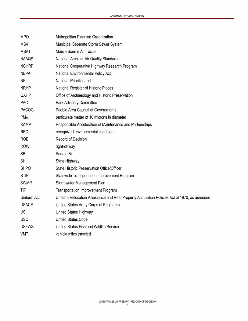
ACRONYM LIST
4P Project Priority Programming Process
ACM Asbestos-containing material
BFE base flood elevation
BMP Best Management Practice
Btu British thermal unit
CDOT Colorado Department of Transportation
CDPHE Colorado Department of Public Health and Environment
CDPS Colorado Discharge Permit System
CEQ Council on Environmental Quality
CFR Code of Federal Regulations
City City of Pueblo
CLOMR Conditional Letter of Map Revision
CO carbon monoxide
CPW Colorado Parks and Wildlife
dBA A-weighted decibel
DEIS Draft Environmental Impact Statement and Section 4(f) Evaluation for I-25 Improvements Through Pueblo
(CDOT and FWHA, 2011)
DOI United States Department of the Interior
EIS Environmental Impact Statement
EO Executive Order
EPA United States Environmental Protection Agency
FEIS Final Environmental Impact Statement and Section 4(f) Evaluation for I-25 Improvements Through Pueblo
(CDOT and FHWA, 2013)
FEMA Federal Emergency Management Agency
FHWA Federal Highway Administration
FIRM Flood Insurance Rate Map
I-25 Interstate 25
ISA Initial Site Assessment
LEDPA Least Environmentally Damaging Practicable Alternative
LOMR Letter of Map Revision
LOS level of service
LWCF Land and Water Conservation Fund
LWCF Act Land and Water Conservation Fund Act of 1965
MOU Memorandum of Understanding
ACRONYM LIST (CONTINUED)
I-25 NEW PUEBLO FREEWAY RECORD OF DECISION
v
MPO Metropolitan Planning Organization
MS4 Municipal Separate Storm Sewer System
MSAT Mobile Source Air Toxics
NAAQS National Ambient Air Quality Standards
NCHRP National Cooperative Highway Research Program
NEPA National Environmental Policy Act
NPL National Priorities List
NRHP National Register of Historic Places
OAHP Office of Archaeology and Historic Preservation
PAC Park Advisory Committee
PACOG Pueblo Area Council of Governments
PM10 particulate matter of 10 microns in diameter
RAMP Responsible Acceleration of Maintenance and Partnerships
REC recognized environmental condition
ROD Record of Decision
ROW right-of-way
SB Senate Bill
SH State Highway
SHPO State Historic Preservation Office/Officer
STIP Statewide Transportation Improvement Program
SWMP Stormwater Management Plan
TIP Transportation Improvement Program
Uniform Act Uniform Relocation Assistance and Real Property Acquisition Policies Act of 1970, as amended
USACE United States Army Corps of Engineers
US United States Highway
USC United States Code
USFWS United States Fish and Wildlife Service
VMT vehicle miles traveled
I-25 NEW PUEBLO FREEWAY RECORD OF DECISION
1-1
1.0 INTRODUCTION
1.1 BACKGROUND
The Federal Highway Administration (FHWA) published a Notice of Intent to prepare an Environmental Impact Statement (EIS) on
January 27, 2004 in the Federal Register in accordance with the Council on Environmental Quality (CEQ) and FHWA regulations.
This Interstate 25 (I-25) New Pueblo Freeway Record of Decision (ROD) has been prepared in compliance with 23 Code of
Federal Regulations (CFR) 771 and 23 CFR 774 and with 40 CFR 1500-1508 and the requirements of the National Environmental
Policy Act (NEPA), as amended.
In November 2011, FHWA and Colorado Department of Transportation (CDOT) published the Draft Environmental Impact
Statement and Section 4(f) Evaluation for I-25 Improvements Through Pueblo (CDOT and FWHA, 2011) (DEIS), which
preliminarily identified a Preferred Alternative (the Modified I-25 Alternative) based on consideration of the goals and objectives
identified in the Purpose and Need as well as the potential impacts resulting from the alternatives. After consideration of the public
and agency comments on the DEIS, in addition to the factors noted above, FHWA and CDOT identified the Modified I-25
Alternative as the Preferred Alternative in the Final Environmental Impact Statement and Section 4(f) Evaluation for I-25
Improvements Through Pueblo (CDOT and FWHA, 2013) (FEIS). In August 2013, FHWA and CDOT published the FEIS, which
presented the evaluation of alternatives and the benefits and impacts to natural resources and community resources associated
with each alternative. The FEIS is incorporated into this ROD by reference. Information about the availability of the FEIS is
included on page i at the front of this document. The FEIS described the decision-making process and summarized the analysis
for identifying the alternatives considered for the FEIS, their associated impacts, proposed mitigation, and ability to meet the
Purpose and Need. Appendix G – Public and Agency Comments of the FEIS also included a full accounting of all comments
received on the DEIS provided by the public and agencies and CDOT’s responses to those comments.
As outlined in the FEIS, it is the intent of CDOT and FHWA to implement the Preferred Alternative in its entirety. Due to current
funding limitations and federal requirements that oblige the project to be included in the Pueblo Area Council of Governments
(PACOG) fiscally constrained plan, only Phase 1 of the Preferred Alternative will be selected with the approval of this ROD.
This ROD is the final step in the NEPA process for Phase 1 of the Preferred Alternative.
1.2 PURPOSE AND NEED
The purpose of the New Pueblo Freeway project is to: 1) improve safety by addressing deteriorating roadways and bridges and
non-standard road characteristics on I-25; and 2) improve local and regional mobility within and through Pueblo to meet existing
and future travel demands.
Construction of I-25 through Pueblo began in 1949 and was completed in 1959. The roadway was constructed before the
Interstate Highway System and its associated design guidelines had been created. As a result of its age and the design practices
at the time it was built, this segment of I-25 contains structural and operational deficiencies. Today, these deficiencies (needs) are
becoming apparent through transportation problems that can be grouped as follows:
Safety Problems. This segment of I-25 has high accident rates that exceed state averages, areas where shoulders are too
narrow to safely accommodate a broken-down vehicle, on and off ramps with inadequate lengths to maneuver vehicles, and
inadequate spacing of interchanges to safely merge and weave into highway traffic.
Mobility Problems. In this segment of I-25, there are interchanges that do not connect to appropriate City of Pueblo (City)
streets, a lack of alternate routes for north-south and east-west connectivity, areas of reduced speed, insufficient capacity for
projected traffic forecasts and poor levels of service, aging bridges with inadequate bridge sufficiency ratings, and conflicts with
local and regional travel.
For additional information related to the factors supporting the project safety and mobility needs, please refer to Chapter 1 –
Purpose and Need of the FEIS.
I-25 NEW PUEBLO FREEWAY RECORD OF DECISION
2-1
2.0 IDENTIFICATION OF THE PREFERRED ALTERNATIVE
2.1 DEVELOPMENT AND SCREENING OF ALTERNATIVES
CDOT and FHWA recognized that the decision for improvements to I-25 through Pueblo would require a multi-disciplinary
approach to developing alternatives that would involve a team of transportation and highway design professionals/engineers,
environmental managers, public involvement specialists, and a wide range of community stakeholders with an interest in the
outcome of the project. To implement this approach, representatives from FHWA and CDOT joined a consultant team of
professionals in a variety of disciplines to form the CDOT Project Team. The CDOT Project Team followed the guidelines of the
National Cooperative Highway Research Program (NCHRP) Report 480, A Guide to Best Practices for Achieving Context
Sensitive Solutions, for studying improvements to I-25 through Pueblo (NCHRP, 2002). Using the process outlined in the Context
Sensitive Solutions guidelines resulted in a Community Vision (Chapter 1 – Purpose and Need, Section 1.4 Vision Statement of
the FEIS) and transportation solutions that meet the Purpose and Need for the project, were sensitive to environmental and
community resources, and reflected community values.
To ensure a comprehensive and rigorous evaluation of possible solutions, the CDOT Project Team used three levels of evaluation
and screening: 1) Evaluation and Screening of Ideas, 2) Evaluation and Screening of Concepts, and 3) Evaluation and Screening
of Strategies. The alternatives development and screening process, described in detail in Chapter 2 – Alternatives of the FEIS,
resulted in the following final alternatives that represent the full range of all reasonable alternatives and were fully evaluated in the
FEIS:
No Action Alternative
Existing I-25 Alternative
Modified I-25 Alternative
The Modified I-25 Alternative is the Preferred Alternative.
2.1.1 Final Detailed Alternatives
Descriptions of the final detailed alternatives are provided below.
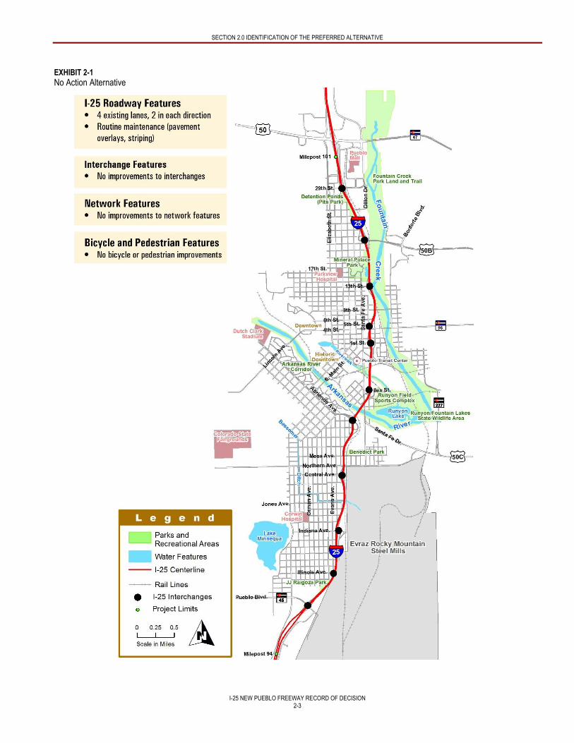
No Action Alternative
The No Action Alternative consists of no capital improvements in the I-25 corridor study area but does include routine
maintenance such as pavement overlays and restriping of the existing facility, as defined in PACOG’s fiscally constrained Pueblo
Area 2035 Long Range Transportation Plan (PACOG, 2008), and eventually the replacement of deficient structures. These
routine maintenance projects have committed funding, as described in the Pueblo Area 2035 Long Range Transportation Plan,
and will occur sometime over the next 20 years. As with the Build Alternatives, the No Action Alternative underwent a thorough
analysis to measure how well it met the project Purpose and Need and evaluation criteria. Analysis of the No Action Alternative in
the FEIS provided a benchmark, enabling decision-makers to compare the magnitude of the environmental effects of each of the
Build Alternatives to the scenario of not making any improvements to I-25 through Pueblo. An overview of the roadway,
interchange, network, bicycle, and pedestrian features of the No Action Alternative is provided and illustrated in Exhibit 2-1.
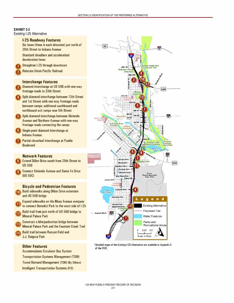
Existing I-25 Alternative
To meet projected capacity needs, the Existing I-25 Alternative would widen I-25 to six lanes (three in each direction) from just
north of 29th Street to Indiana Avenue and maintain four lanes (two in each direction) from Indiana Avenue to Pueblo Boulevard
on its current alignment. As shown in Exhibit 2-2, the Existing I-25 Alternative would reconstruct the interchanges at United
States Highway (US) 50B, Indiana Avenue, and Pueblo Boulevard; provide access to 29th Street via a frontage road; and create
a split-diamond interchange between 13th Street and 1st Street. The split-diamond configuration serving the downtown area
would allow access to 1st Street, 4th Street, 8th Street, and 13th Street. Another split-diamond interchange between Abriendo
SECTION 2.0 IDENTIFICATION OF THE PREFERRED ALTERNATIVE
I-25 NEW PUEBLO FREEWAY RECORD OF DECISION
2-2
Avenue and Northern Avenue would consolidate access and straighten the existing highway curves; however, this reconfiguration
requires the removal of highway access at Central Avenue and the closure of Currie Street.
The Existing I-25 Alternative would improve connectivity off of I-25 by extending Dillon Drive south from 26th Street to US 50B. It
would also extend Abriendo Avenue across I-25 to Santa Fe Drive. This connection would provide improved access between the
neighborhoods west and east of I-25.
The Existing I-25 Alternative would generally match the current I-25 elevation, except in a few areas where a change in the
highway grade would be necessary to address safety problems. For example, through downtown, I-25 would be 25 to 40 feet
higher than it is currently, which would eliminate the steep vertical curves in this area. There would also be a 20- to 30-foot rise in
elevation at the Indiana Avenue interchange in order to develop a full interchange at Indiana Avenue and provide enough
clearance for east-west traffic moving underneath I-25. The Existing I-25 Alternative would require the relocation of approximately
1.41 miles of UPRR tracks to the east between Abriendo Avenue and Minnequa Avenue to accommodate a wider highway
footprint.
Ownership and maintenance of the new facilities included in the Existing I-25 Alternative are detailed in the Memorandum of
Understanding (MOU) between CDOT and the City, which was finalized in March 2010 (see Appendix F – Memorandum of
Understanding Between the City of Pueblo and Colorado Department of Transportation of the FEIS).
Modified I-25 Alternative (Preferred Alternative)
To meet projected capacity needs, the Modified I-25 Alternative (Preferred Alternative) would widen I-25 to six lanes (three in
each direction) from just north of 29th Street to Indiana Avenue and maintain four lanes (two in each direction) from Indiana
Avenue to Pueblo Boulevard. The Modified I-25 Alternative (Preferred Alternative), shown in Exhibit 2-3, was developed from the
Existing I-25 Alternative by the CDOT Project Team and stakeholders and shares the design characteristics of the Existing I-25
Alternative, with the exception of one area of the corridor known as the Central Area, as described in the next paragraph.
In the Central Area of the corridor (between the Arkansas River and Canal Street), implementing the Existing I-25 Alternative
would require moving the UPRR tracks 150 feet to the east to make room for widening I-25. Difficulties associated with moving
the rail line led to the idea of relocating I-25 to a new alignment to the east at approximately Ilex Street. Moving I-25 to the new
alignment in this area would allow the UPRR rail line south of the Arkansas River to remain in place. At approximately Minnequa
Avenue, I-25 would bridge over the railroad tracks and run on the west side of the tracks, rejoining the existing I-25 alignment just
south of Indiana Avenue.
The Modified I-25 Alternative (Preferred Alternative) was found to have unexpected benefits in the southern end of the corridor.
By straightening I-25 at Ilex Street, I-25 would leave the existing alignment and continue south. The roadway no longer used as
I-25 would be available to become an extension of Santa Fe Avenue, providing a local road that drivers could use to travel north-
south through Pueblo without having to drive on I-25. This extension would not be possible under the Existing I-25 Alternative.
A second unexpected benefit of the Modified I-25 Alternative (Preferred Alternative) is that a new east-west direct connection
would be made between Abriendo Avenue and Santa Fe Drive. This connection would provide improved access between the
neighborhoods west and east of I-25. An overview of the roadway, interchange, network, bicycle, and pedestrian features of this
Build Alternative is provided and illustrated in Exhibit 2-3 and additional detailed figures can be found in Appendix A of this
document.
The Modified I-25 Alternative (Preferred Alternative) would generally match the current I-25 elevation in areas where the
alignment follows the current highway alignment, except in one key area where a change in the vertical grades is necessary to
address safety problems. Through the downtown area, I-25 will be 25 to 40 feet higher than it is currently, which will eliminate the
steep vertical curves in this area while providing enough clearance for east-west traffic moving underneath I-25.
SECTION 2.0 IDENTIFICATION OF THE PREFERRED ALTERNATIVE
I-25 NEW PUEBLO FREEWAY RECORD OF DECISION
2-3
EXHIBIT 2-1
No Action Alternative
SECTION 2.0 IDENTIFICATION OF THE PREFERRED ALTERNATIVE
I-25 NEW PUEBLO FREEWAY RECORD OF DECISION
2-4
EXHIBIT 2-2
Existing I-25 Alternative
SECTION 2.0 IDENTIFICATION OF THE PREFERRED ALTERNATIVE
I-25 NEW PUEBLO FREEWAY RECORD OF DECISION
2-5
EXHIBIT 2-3
Modified I-25 Alternative (Preferred Alternative)
SECTION 2.0 IDENTIFICATION OF THE PREFERRED ALTERNATIVE
I-25 NEW PUEBLO FREEWAY RECORD OF DECISION
2-6
Ownership and maintenance of the new facilities included in the Modified I-25 Alternative (Preferred Alternative) are detailed in
the MOU between CDOT and the City, which was finalized in March 2010 (see Appendix F – Memorandum of Understanding
Between the City of Pueblo and Colorado Department of Transportation of the FEIS).
Bicycle and Pedestrian Accommodations for both Build Alternatives
Both Build Alternatives would improve bicycle and pedestrian features by building sidewalks along the Dillon Drive extension and
the US 50B Bridge. The Modified I-25 Alternative (Preferred Alternative) also adds sidewalks along Stanton Avenue, connecting
the Historic Arkansas Riverwalk of Pueblo to Benedict Park. Other bicycle and pedestrian facility improvements for both Build
Alternatives include expanded sidewalks on the Mesa Avenue overpass, new trails from Mineral Palace Park to the US 50B
Bridge and between Runyon Field and JJ Raigoza Park, as well as a new pedestrian bridge between Mineral Palace Park and the
Fountain Creek Trail.
The completion of proposed trails and sidewalks will provide continuous bicycle and pedestrian access between 29th Street in the
north to Pueblo Boulevard in the south. Neighbors will be able to access trails near their homes that will provide families with safe,
non-motorized access to Mineral Palace Park, Benedict Park, JJ Raigoza Park, Historic Arkansas Riverwalk of Pueblo, the
Runyon Field Sports Complex, the Runyon/Fountain Lakes State Wildlife Area, and the Fountain Creek Park Land and Trail
system.
2.2 BASIS FOR IDENTIFICATION OF THE PREFERRED ALTERNATIVE
After careful consideration of the goals and objectives identified in the Purpose and Need, as well as the potential impacts
resulting from the alternatives and public and agency comments, FHWA and CDOT preliminarily identified the Modified I-25
Alternative as the Preferred Alternative for improvements to I-25 through Pueblo in the DEIS for public and agency review. After
consideration of the public and agency comments on the DEIS, in addition to the factors noted above, FHWA and CDOT identified
the Modified I-25 Alternative as the Preferred Alternative in the FEIS. The following discussion characterizes the ability of all the
alternatives to meet the Purpose and Need and other contributing factors supporting the identification of the Preferred Alternative.
2.2.1 How the Preferred Alternative Addresses the Elements of the Purpose and Need
Both Build Alternatives address the safety and capacity elements of the Purpose and Need. In addition, the Preferred Alternative
best meets the local and regional mobility elements as described below.
Both Build Alternatives would restore some connectivity to neighborhoods that were previously divided by the original construction of I-25. However, the Preferred Alternative provides additional connectivity to the north and south with the extension of Stanton Avenue north and west to Santa Fe Avenue and south to Santa Fe Drive. Residents of the Bessemer Neighborhood east of I-25 would be more connected to the rest of the neighborhood, as well as the community resources in the Grove Neighborhood and Downtown Neighborhood. This opportunity is not available under the No Action Alternative or the Existing I-25 Alternative.
The Preferred Alternative improves north-south local and regional mobility by converting the existing I-25 south of the Arkansas River to an extension of Santa Fe Drive to facilitate local trips more efficiently and maintain regional trips on I-25. This opportunity is not available under the No Action Alternative or the Existing I-25 Alternative.
The Preferred Alternative improves east-west local mobility over the Existing I-25 Alternative by providing a more direct connection to I-25 at Abriendo Avenue. Under the Existing I-25 Alternative, drivers on Abriendo Avenue would have to turn at a signalized intersection at Santa Fe Drive to remain on Abriendo Avenue. For the Preferred Alternative, Abriendo Avenue is a direct connection that does not require a turn at a signal.
The extension of Santa Fe Avenue under the Preferred Alternative provides a benefit to residences on the south end between Minnequa Avenue and Logan Avenue by returning the functionality of their properties. When I-25 was originally constructed, homes that had access to Schley Avenue lost that access, and their front doors were adjacent to the new highway. As a result, access to these homes was provided only through the back alley. With the extension of Santa Fe Avenue, access to the front of these homes would be restored.
SECTION 2.0 IDENTIFICATION OF THE PREFERRED ALTERNATIVE
I-25 NEW PUEBLO FREEWAY RECORD OF DECISION
2-7
2.2.2 Other Contributing Factors
In addition to the Purpose and Need, other factors were considered in the identification of the Preferred Alternative, including the
cost effectiveness of each Build Alternative; the recommendation of local officials; a comparison of potential impacts to the
environment under each Build Alternative; and consistency with other regulatory requirements, in particular Section 4(f) of the
United States Department of Transportation Act of 1966 and Section 404 of the Clean Water Act, both of which have specific
requirements that must be met by the Preferred Alternative. Each of these elements is summarized below.
Difference in Cost Between the Alternatives
The construction cost of each Build Alternative was considered; however, the costs between the two Build Alternatives were too
similar to be a differentiating factor. The Existing I-25 Alternative would cost approximately $710.1 million to construct, and the
Preferred Alternative would cost approximately $760.5 million to construct.
Public and Agency Support for the Preferred Alternative
The City of Pueblo Parks and Recreation Department expressed support for the Preferred Alternative in a letter dated July 13,
2010. Preference for the Preferred Alternative was based on improved trail connections and facilitation of north-south movement
in the corridor. City officials have influenced the design of the Preferred Alternative and have assisted with the identification of
appropriate mitigation measures. Support for the Preferred Alternative has also been provided by the Project Leadership Team.
(For information on the membership, roles and responsibilities, and contributions of this team, refer to Chapter 6 – Comments and
Coordination of the FEIS). In 2013, the City Council of Pueblo, PACOG, and Pueblo County Commissioners each expressed
support and preference for the Modified I-25 Alternative as the Preferred Alternative in formal resolutions, which can be found in
Appendix B – Agency Consultation and Coordination of the FEIS.
The CDOT Project Team used an extensive public involvement approach during the development of each alternative, as
discussed in Chapter 6 – Comments and Coordination of the FEIS. Throughout the development of the Build Alternatives, the
public consistently expressed preference for the Preferred Alternative. During the formal comment period for the DEIS, residents
of the Bessemer Neighborhood east of I-25 and south of Mesa Avenue expressed concern about impacts to their community as a
result of the Preferred Alternative, in particular, the number of property acquisitions that would be required south of Mesa Avenue.
CDOT and the City met with representatives from the community in the beginning of 2012 to discuss these concerns and identify
additional mitigation measures, which are documented in Chapter 3 – Affected Environment and Environmental Consequences,
Section 3.6 Social Resources, Economic Conditions, and Environmental Justice in the FEIS.
Difference in Environmental Impacts Between the Alternatives
New Pueblo Freeway project impacts were evaluated and organized by three geographic areas within the project area: North,
Central, and South. The North Area extends from just north of 29th Street to Ilex Street. The Central Area continues from Ilex
Street to Nevada Avenue. The South Area extends between Nevada Avenue and milepost 94, just south of the Pueblo Boulevard
interchange. Both Build Alternatives share the same impacts in the North Area and South Area of the project. The only difference
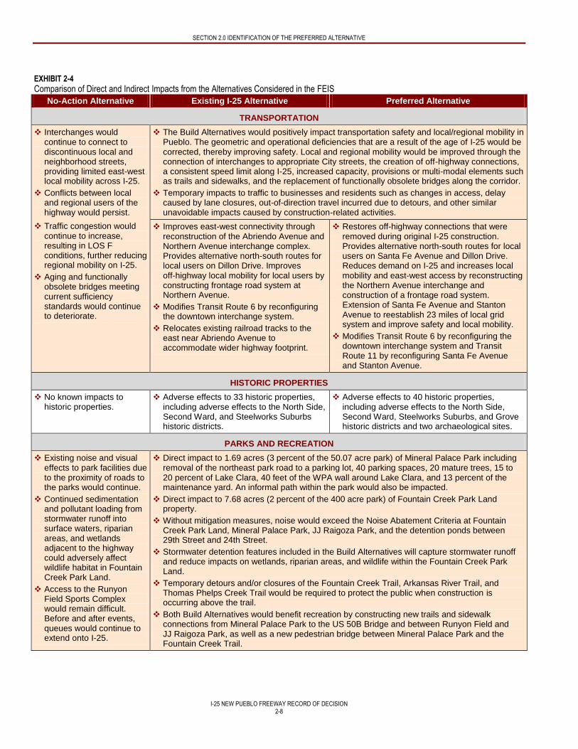
in impacts occurs in the Central Area of the project between Ilex Street and the Evraz Rocky Mountain Steel Mills. Exhibit 2-4
summarizes the direct and indirect impacts that would result from the No Action Alternative, Existing I-25 Alternative, and the
Preferred Alternative.
SECTION 2.0 IDENTIFICATION OF THE PREFERRED ALTERNATIVE
I-25 NEW PUEBLO FREEWAY RECORD OF DECISION
2-8
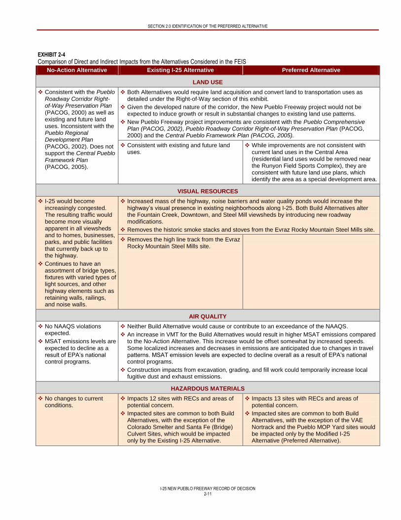
EXHIBIT 2-4
Comparison of Direct and Indirect Impacts from the Alternatives Considered in the FEIS
No-Action Alternative Existing I-25 Alternative Preferred Alternative
TRANSPORTATION
Interchanges would continue to connect to discontinuous local and neighborhood streets, providing limited east-west local mobility across I-25.
Conflicts between local and regional users of the highway would persist.
Traffic congestion would continue to increase, resulting in LOS F conditions, further reducing regional mobility on I-25.
Aging and functionally obsolete bridges meeting current sufficiency standards would continue to deteriorate.
The Build Alternatives would positively impact transportation safety and local/regional mobility in Pueblo. The geometric and operational deficiencies that are a result of the age of I-25 would be corrected, thereby improving safety. Local and regional mobility would be improved through the connection of interchanges to appropriate City streets, the creation of off-highway connections, a consistent speed limit along I-25, increased capacity, provisions or multi-modal elements such as trails and sidewalks, and the replacement of functionally obsolete bridges along the corridor.
Temporary impacts to traffic to businesses and residents such as changes in access, delay caused by lane closures, out-of-direction travel incurred due to detours, and other similar unavoidable impacts caused by construction-related activities.
Improves east-west connectivity through reconstruction of the Abriendo Avenue and Northern Avenue interchange complex. Provides alternative north-south routes for local users on Dillon Drive. Improves off-highway local mobility for local users by constructing frontage road system at Northern Avenue.
Modifies Transit Route 6 by reconfiguring the downtown interchange system.
Relocates existing railroad tracks to the east near Abriendo Avenue to accommodate wider highway footprint.
Restores off-highway connections that were removed during original I-25 construction. Provides alternative north-south routes for local users on Santa Fe Avenue and Dillon Drive. Reduces demand on I-25 and increases local mobility and east-west access by reconstructing the Northern Avenue interchange and construction of a frontage road system. Extension of Santa Fe Avenue and Stanton Avenue to reestablish 23 miles of local grid system and improve safety and local mobility.
Modifies Transit Route 6 by reconfiguring the downtown interchange system and Transit Route 11 by reconfiguring Santa Fe Avenue and Stanton Avenue.
HISTORIC PROPERTIES
No known impacts to historic properties.
Adverse effects to 33 historic properties, including adverse effects to the North Side, Second Ward, and Steelworks Suburbs historic districts.
Adverse effects to 40 historic properties, including adverse effects to the North Side, Second Ward, Steelworks Suburbs, and Grove historic districts and two archaeological sites.
PARKS AND RECREATION
Existing noise and visual effects to park facilities due to the proximity of roads to the parks would continue.
Continued sedimentation and pollutant loading from stormwater runoff into surface waters, riparian areas, and wetlands adjacent to the highway could adversely affect wildlife habitat in Fountain Creek Park Land.
Access to the Runyon Field Sports Complex would remain difficult. Before and after events, queues would continue to extend onto I-25.
Direct impact to 1.69 acres (3 percent of the 50.07 acre park) of Mineral Palace Park including removal of the northeast park road to a parking lot, 40 parking spaces, 20 mature trees, 15 to 20 percent of Lake Clara, 40 feet of the WPA wall around Lake Clara, and 13 percent of the maintenance yard. An informal path within the park would also be impacted.
Direct impact to 7.68 acres (2 percent of the 400 acre park) of Fountain Creek Park Land property.
Without mitigation measures, noise would exceed the Noise Abatement Criteria at Fountain Creek Park Land, Mineral Palace Park, JJ Raigoza Park, and the detention ponds between 29th Street and 24th Street.
Stormwater detention features included in the Build Alternatives will capture stormwater runoff and reduce impacts on wetlands, riparian areas, and wildlife within the Fountain Creek Park Land.
Temporary detours and/or closures of the Fountain Creek Trail, Arkansas River Trail, and Thomas Phelps Creek Trail would be required to protect the public when construction is occurring above the trail.
Both Build Alternatives would benefit recreation by constructing new trails and sidewalk connections from Mineral Palace Park to the US 50B Bridge and between Runyon Field and JJ Raigoza Park, as well as a new pedestrian bridge between Mineral Palace Park and the Fountain Creek Trail.
SECTION 2.0 IDENTIFICATION OF THE PREFERRED ALTERNATIVE
I-25 NEW PUEBLO FREEWAY RECORD OF DECISION
2-9
EXHIBIT 2-4
Comparison of Direct and Indirect Impacts from the Alternatives Considered in the FEIS
No-Action Alternative Existing I-25 Alternative Preferred Alternative
Direct impact to 0.42 acre of Benedict Park, including the elimination of the informal athletic field.
Direct impact to Benedict Park, resulting in the acquisition of the entire park (1.92 acres) and its facilities.
Direct impacts of up to 2.81 acres of the Runyon/Fountain Lakes State Wildlife Area. Includes the removal of the existing pedestrian bridge over the Arkansas River. The trail leading to the existing pedestrian bridge would also need to be relocated to a new river crossing location. The park benches would also need to be moved to the east.
Extension of Stanton Avenue would benefit Runyon Field Sports Complex by providing access to the park from the local road network instead of I-25 and minimizing traffic queues on I-25.
Requires the conversion of 6.68 acres of Section 6(f) property1, including 6.26 acres from Fountain Creek Park Land3 and 0.42 acres from Benedict Park.
Requires the conversion of between 8.18 acres and 10.99 acres of Section 6(f) property1,3
including 6.68 acres from Fountain Creek Park Land2, 1.92 acres from Benedict Park, and between 0 and 2.81 acres from Runyon/Fountain Lakes State Wildlife Area.
RIGHT-OF-WAY
Would not require acquisition of property or any relocations.
Construction would require a total of 273 acquisitions (219 total acquisitions and 54 partial acquisitions) and 154 acres (74 total acquisitions and 80 partial acquisitions).
Residential property impacts include 87 total acquisitions (9 acres) and 2 partial acquisitions (<1 acre).
Commercial property impacts include 53 total acquisitions (32 acres) and 25 partial acquisitions (36 acres). A total of 59 businesses would be displaced.
Vacant undeveloped property impacts include 66 total acquisitions (27 acres) and 14 partial acquisitions (37 acres).
Public property impacts include 13 total acquisitions (6 acres) and 13 partial acquisitions (6 acres).
Construction would require a total of 309 acquisitions (246 total acquisitions and 63 partial acquisitions) and 178 acres (84 total acquisitions and 94 partial acquisitions).
Residential property impacts include 117 total acquisitions (14 acres) and 0 partial acquisitions.
Commercial property impacts include 56 total acquisitions (34 acres) and 26 partial acquisitions (46 acres). A total of 65 businesses would be displaced.
Vacant undeveloped property impacts include 58 total acquisitions (27 acres) and 22 partial acquisitions (42 acres).
Public property impacts include 15 total acquisitions (9 acres) and 15 partial acquisitions (6 acres)
SECTION 2.0 IDENTIFICATION OF THE PREFERRED ALTERNATIVE
I-25 NEW PUEBLO FREEWAY RECORD OF DECISION
2-10
EXHIBIT 2-4
Comparison of Direct and Indirect Impacts from the Alternatives Considered in the FEIS
No-Action Alternative Existing I-25 Alternative Preferred Alternative
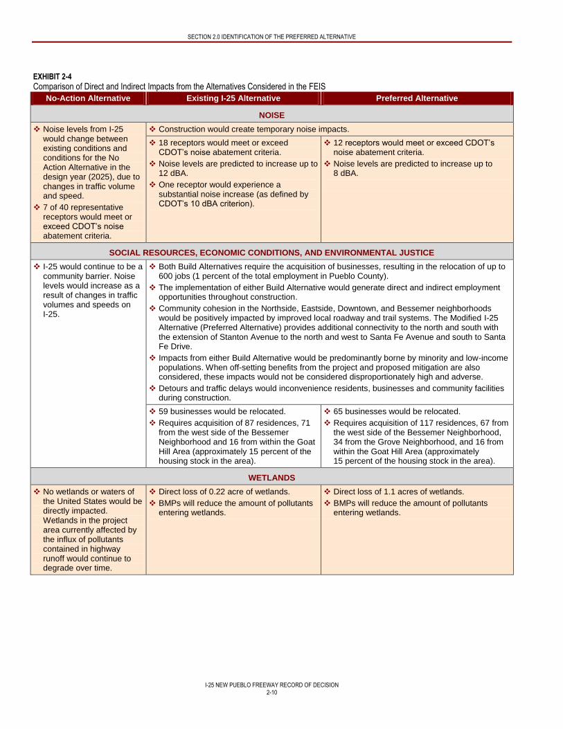
NOISE
Noise levels from I-25 would change between existing conditions and conditions for the No Action Alternative in the design year (2025), due to changes in traffic volume and speed.
7 of 40 representative receptors would meet or exceed CDOT’s noise abatement criteria.
Construction would create temporary noise impacts.
18 receptors would meet or exceed CDOT’s noise abatement criteria.
Noise levels are predicted to increase up to 12 dBA.
One receptor would experience a substantial noise increase (as defined by CDOT’s 10 dBA criterion).
12 receptors would meet or exceed CDOT’s noise abatement criteria.
Noise levels are predicted to increase up to 8 dBA.
SOCIAL RESOURCES, ECONOMIC CONDITIONS, AND ENVIRONMENTAL JUSTICE
I-25 would continue to be a community barrier. Noise levels would increase as a result of changes in traffic volumes and speeds on I-25.
Both Build Alternatives require the acquisition of businesses, resulting in the relocation of up to 600 jobs (1 percent of the total employment in Pueblo County).
The implementation of either Build Alternative would generate direct and indirect employment opportunities throughout construction.
Community cohesion in the Northside, Eastside, Downtown, and Bessemer neighborhoods would be positively impacted by improved local roadway and trail systems. The Modified I-25 Alternative (Preferred Alternative) provides additional connectivity to the north and south with the extension of Stanton Avenue to the north and west to Santa Fe Avenue and south to Santa Fe Drive.
Impacts from either Build Alternative would be predominantly borne by minority and low-income populations. When off-setting benefits from the project and proposed mitigation are also considered, these impacts would not be considered disproportionately high and adverse.
Detours and traffic delays would inconvenience residents, businesses and community facilities during construction.
59 businesses would be relocated.
Requires acquisition of 87 residences, 71 from the west side of the Bessemer Neighborhood and 16 from within the Goat Hill Area (approximately 15 percent of the housing stock in the area).
65 businesses would be relocated.
Requires acquisition of 117 residences, 67 from the west side of the Bessemer Neighborhood, 34 from the Grove Neighborhood, and 16 from within the Goat Hill Area (approximately 15 percent of the housing stock in the area).
WETLANDS
No wetlands or waters of the United States would be directly impacted. Wetlands in the project area currently affected by the influx of pollutants contained in highway runoff would continue to degrade over time.
Direct loss of 0.22 acre of wetlands.
BMPs will reduce the amount of pollutants entering wetlands.
Direct loss of 1.1 acres of wetlands.
BMPs will reduce the amount of pollutants entering wetlands.
SECTION 2.0 IDENTIFICATION OF THE PREFERRED ALTERNATIVE
I-25 NEW PUEBLO FREEWAY RECORD OF DECISION
2-11
EXHIBIT 2-4
Comparison of Direct and Indirect Impacts from the Alternatives Considered in the FEIS
No-Action Alternative Existing I-25 Alternative Preferred Alternative
LAND USE
Consistent with the Pueblo Roadway Corridor Right-of-Way Preservation Plan (PACOG, 2000) as well as existing and future land uses. Inconsistent with the Pueblo Regional Development Plan (PACOG, 2002). Does not support the Central Pueblo Framework Plan (PACOG, 2005).
Both Alternatives would require land acquisition and convert land to transportation uses as detailed under the Right-of-Way section of this exhibit.
Given the developed nature of the corridor, the New Pueblo Freeway project would not be expected to induce growth or result in substantial changes to existing land use patterns.
New Pueblo Freeway project improvements are consistent with the Pueblo Comprehensive Plan (PACOG, 2002), Pueblo Roadway Corridor Right-of-Way Preservation Plan (PACOG, 2000) and the Central Pueblo Framework Plan (PACOG, 2005).
Consistent with existing and future land uses.
While improvements are not consistent with current land uses in the Central Area (residential land uses would be removed near the Runyon Field Sports Complex), they are consistent with future land use plans, which identify the area as a special development area.
VISUAL RESOURCES
I-25 would become increasingly congested. The resulting traffic would become more visually apparent in all viewsheds and to homes, businesses, parks, and public facilities that currently back up to the highway.
Continues to have an assortment of bridge types, fixtures with varied types of light sources, and other highway elements such as retaining walls, railings, and noise walls.
Increased mass of the highway, noise barriers and water quality ponds would increase the highway’s visual presence in existing neighborhoods along I-25. Both Build Alternatives alter the Fountain Creek, Downtown, and Steel Mill viewsheds by introducing new roadway modifications.
Removes the historic smoke stacks and stoves from the Evraz Rocky Mountain Steel Mills site.
Removes the high line track from the Evraz Rocky Mountain Steel Mills site.
AIR QUALITY
No NAAQS violations expected.
MSAT emissions levels are expected to decline as a result of EPA’s national control programs.
Neither Build Alternative would cause or contribute to an exceedance of the NAAQS.
An increase in VMT for the Build Alternatives would result in higher MSAT emissions compared to the No-Action Alternative. This increase would be offset somewhat by increased speeds. Some localized increases and decreases in emissions are anticipated due to changes in travel patterns. MSAT emission levels are expected to decline overall as a result of EPA’s national control programs.
Construction impacts from excavation, grading, and fill work could temporarily increase local fugitive dust and exhaust emissions.
HAZARDOUS MATERIALS
No changes to current conditions.
Impacts 12 sites with RECs and areas of potential concern.
Impacted sites are common to both Build Alternatives, with the exception of the Colorado Smelter and Santa Fe (Bridge) Culvert Sites, which would be impacted only by the Existing I-25 Alternative.
Impacts 13 sites with RECs and areas of potential concern.
Impacted sites are common to both Build Alternatives, with the exception of the VAE Nortrack and the Pueblo MOP Yard sites would be impacted only by the Modified I-25 Alternative (Preferred Alternative).

SECTION 2.0 IDENTIFICATION OF THE PREFERRED ALTERNATIVE
I-25 NEW PUEBLO FREEWAY RECORD OF DECISION
2-12
EXHIBIT 2-4
Comparison of Direct and Indirect Impacts from the Alternatives Considered in the FEIS
No-Action Alternative Existing I-25 Alternative Preferred Alternative
FISH AND WILDLIFE HABITAT
No changes to current conditions.
Loss of low-quality nesting habitat for migratory birds.
Both Build Alternatives result in noise from construction activities that could affect wildlife species, and could temporarily displace migratory bird and raptor species. Construction activities could also affect wildlife by removing vegetation and wildlife habitats.
Direct loss of 8.95 acres of wildlife habitat. Extension of Abriendo Avenue would divide wetlands and wooded upland habitat near Santa Fe Avenue.
Construction of new bridge piers over the Arkansas River would impact 0.01 acre of open water.
Direct loss of 18.10 acres of wildlife habitat. Shifting I-25 to the east would result in fragmentation of riparian habitat along the Arkansas River and removal of 60 percent of the wooded upland habitat and almost all of the wetland near Santa Fe Avenue.
Construction of new bridge piers over the Arkansas River would impact 0.08 acre of open water.
SENSITIVE SPECIES
No changes to current conditions.
Impacts to 5.21 acres of plains leopard frog habitat.
Impacts to 0.14 acre of Arkansas darter habitat.
Impacts to 8.62 acres of plains leopard frog habitat.
Impacts to 0.15 acre of Arkansas darter habitat.
FLOODPLAINS
No changes to current conditions.
Impacts to 3.35 acres of the Fountain Creek Floodplain near the US 50B Bridge during a 100-year flood event, in an area not currently within the 100-year floodplain boundaries. The new bridge would have a greater conveyance capacity, resulting in a decrease in BFE near the bridge. The Dillon Drive extension results in two longitudinal encroachments of the floodplain. Increases the BFE and floodplain width upstream of the new Dillon Drive embankment; increases channel velocity below the embankment.
Impacts to the Arkansas River Floodplain for the Existing I-25 Alternative would be limited to replacement of the existing I-25 bridge in its approximate current location. In the area where the new piers would be placed, model results showed a slight (0.1 foot) decrease in BFE, reduction in floodplain width (3 feet), and an increase in velocity (between 0.3 and 0.4 feet per second), which would be an improvement to the existing floodplain.
Impacts to the Arkansas River Floodplain for the Modified I-25 Alternative (Preferred Alternative) would be located east of the existing bridge and would result in a new transverse encroachment on the floodplain and floodway.
The width of the Arkansas River Floodplain would increase by 2 feet north of the Arkansas Bridge location, however the floodplain width decreases by approximately 129 feet downstream, where the velocities are predicted to increase by 0.1 feet per second.
Implementation of the Modified I-25 Alternative (Preferred Alternative) would not flood any new areas that were not within the existing 100-year Arkansas River Floodplain.
SECTION 2.0 IDENTIFICATION OF THE PREFERRED ALTERNATIVE
I-25 NEW PUEBLO FREEWAY RECORD OF DECISION
2-13
EXHIBIT 2-4
Comparison of Direct and Indirect Impacts from the Alternatives Considered in the FEIS
No-Action Alternative Existing I-25 Alternative Preferred Alternative
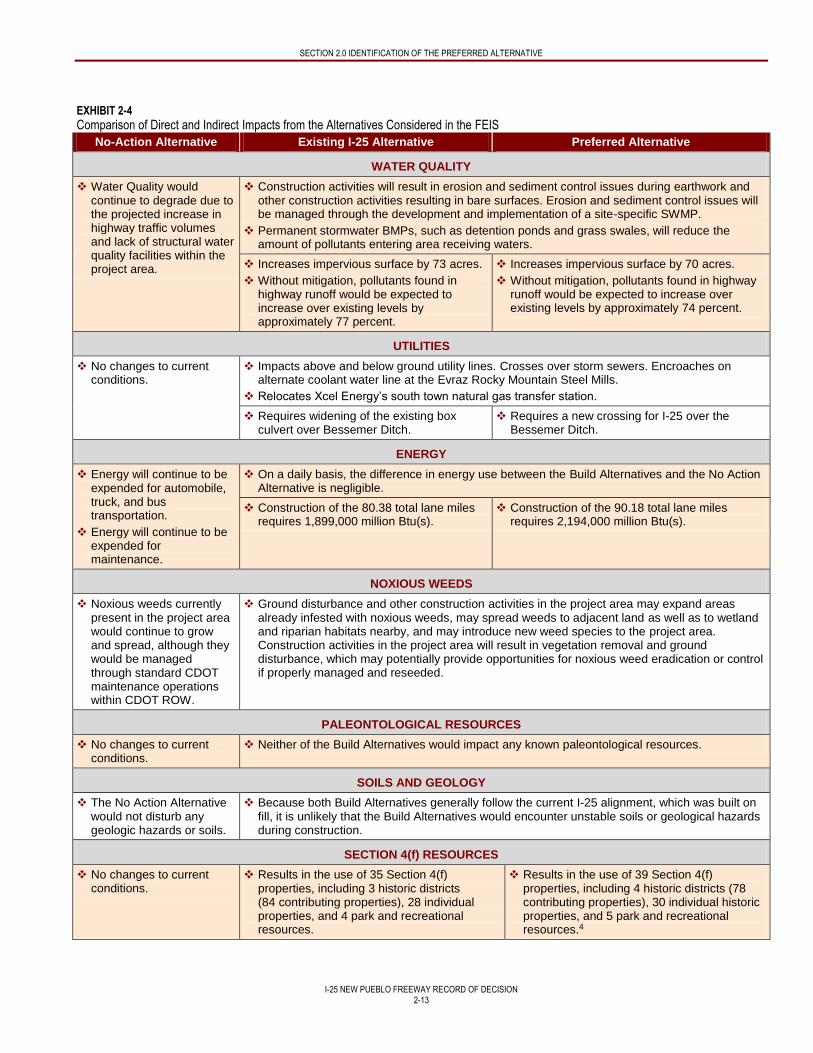
WATER QUALITY
Water Quality would continue to degrade due to the projected increase in highway traffic volumes and lack of structural water quality facilities within the project area.
Construction activities will result in erosion and sediment control issues during earthwork and other construction activities resulting in bare surfaces. Erosion and sediment control issues will be managed through the development and implementation of a site-specific SWMP.
Permanent stormwater BMPs, such as detention ponds and grass swales, will reduce the amount of pollutants entering area receiving waters.
Increases impervious surface by 73 acres.
Without mitigation, pollutants found in highway runoff would be expected to increase over existing levels by approximately 77 percent.
Increases impervious surface by 70 acres.
Without mitigation, pollutants found in highway runoff would be expected to increase over existing levels by approximately 74 percent.
UTILITIES
No changes to current conditions.
Impacts above and below ground utility lines. Crosses over storm sewers. Encroaches on alternate coolant water line at the Evraz Rocky Mountain Steel Mills.
Relocates Xcel Energy’s south town natural gas transfer station.
Requires widening of the existing box culvert over Bessemer Ditch.
Requires a new crossing for I-25 over the Bessemer Ditch.
ENERGY
Energy will continue to be expended for automobile, truck, and bus transportation.
Energy will continue to be expended for maintenance.
On a daily basis, the difference in energy use between the Build Alternatives and the No Action Alternative is negligible.
Construction of the 80.38 total lane miles requires 1,899,000 million Btu(s).
Construction of the 90.18 total lane miles requires 2,194,000 million Btu(s).
NOXIOUS WEEDS
Noxious weeds currently present in the project area would continue to grow and spread, although they would be managed through standard CDOT maintenance operations within CDOT ROW.
Ground disturbance and other construction activities in the project area may expand areas already infested with noxious weeds, may spread weeds to adjacent land as well as to wetland and riparian habitats nearby, and may introduce new weed species to the project area. Construction activities in the project area will result in vegetation removal and ground disturbance, which may potentially provide opportunities for noxious weed eradication or control if properly managed and reseeded.
PALEONTOLOGICAL RESOURCES
No changes to current conditions.
Neither of the Build Alternatives would impact any known paleontological resources.
SOILS AND GEOLOGY
The No Action Alternative would not disturb any geologic hazards or soils.
Because both Build Alternatives generally follow the current I-25 alignment, which was built on fill, it is unlikely that the Build Alternatives would encounter unstable soils or geological hazards during construction.
SECTION 4(f) RESOURCES
No changes to current conditions.
Results in the use of 35 Section 4(f) properties, including 3 historic districts (84 contributing properties), 28 individual properties, and 4 park and recreational resources.
Results in the use of 39 Section 4(f) properties, including 4 historic districts (78 contributing properties), 30 individual historic properties, and 5 park and recreational resources.4
SECTION 2.0 IDENTIFICATION OF THE PREFERRED ALTERNATIVE
I-25 NEW PUEBLO FREEWAY RECORD OF DECISION
2-14
1 Section 6(f)(3) assisted properties include parks and recreational facilities that have been acquired through the use of grants from the LWCF Act. Section 6(f) of the LWCF Act ensures that federal investments in the LWCF are maintained for public outdoor recreational use. The LWCF Act requires that, prior to conversion of Section 6(f)(3) assisted property, the agency proposing the conversion must evaluate all practical alternatives to the conversion and identify adequate replacement property. 2 Of the 7.68 acres of impact to Fountain Creek Park Land, 6.26 acres constitute a Section 6(f) conversion. The 1.42 acres of land associated with the stormwater detention features in this area would not be considered a conversion of Section 6(f) property because the ponds would remain open for recreation and would still function as open space. 3 The variation in impacts for the Preferred Alternative is due to discrepancies in the mapping of the Section 6(f) boundary for Runyon/Fountain Lakes State Wildlife Area. If it is determined that none of the improvements are located within the boundary, there would be no Section 6(f) use of this property and the Build Alternatives would only differ in the Section 6(f) use of Benedict Park. This issue will be resolved in further consultation with the Colorado Parks and Wildlife as the project is developed and funded. 4 The FEIS identified the Preferred Alternative as the alternative that results in the least overall harm to Section 4(f) properties based on the ability to mitigate adverse impacts, the relative severity of the remaining harm after mitigation, the views of the officials with jurisdiction, and the degree to which the alternative meets the Purpose and Need for the project.
ACM = asbestos containing material LCWF = Land and Water Conservation Fund BFE = base flood elevation LWCF Act = Land and Water Conservation BMP = Best Management Practice MSAT = Mobile Source Air Toxics Btu = British thermal unit NAAQS = National Ambient Air Quality Standards CDOT = Colorado Department of Transportation PACOG = Pueblo Area Council of Governments CPW = Colorado Parks and Wildlife REC = Recognized Environmental Condition dBA = A-weighted decibel ROW = right-of-way EPA = United States Environmental Protection Agency SWMP = Stormwater Management Plan I-25 = Interstate 25 VMT = vehicle miles traveled
The primary differences in impacts between the Build Alternatives are as follows:
Each of the Build Alternatives would positively impact local and regional mobility, however the Preferred Alternative provides additional north-south connectivity with the extension of Stanton Avenue, Santa Fe Avenue, and Santa Fe Drive. Additional east-west mobility improvements are provided by a more direct connection to I-25 at Abriendo Avenue in the Preferred Alternative.
Wetlands impacts would differ by less than 1 acre, with the Preferred Alternative impacting 0.88 acre more wetlands area than the Existing I-25 Alternative.
Impacts to non-wetland waters of the United States (as defined by the United States Army Corps of Engineers [USACE]) are nearly equal for the two alternatives. Under the Existing I-25 Alternative, the single bridge piers currently in place at the Arkansas River crossing would be removed and replaced; however, they would be placed in the same locations as the existing piers and designed to occupy a slightly smaller footprint. For the Preferred Alternative, 18 new bridge piers would be placed in the Arkansas River to support the bridges for I-25, two ramps, and the extension of Stanton Avenue, resulting in 0.02 acre of impacts to the Arkansas River.
Although the Preferred Alternative would impact seven additional historic properties compared to the Existing I-25 Alternative, the Preferred Alternative would have fewer impacts to properties within the Steelworks Suburbs Historic District, with 56 being fully or partially acquired compared to 68 properties under the Existing I-25 Alternative.
Both Build Alternatives would impact Benedict Park. While the initial impact would be greater under the Preferred Alternative, the Preferred Alternative allows for the construction of a new park that would be a minimum 3.93 acres to a maximum 4.30 acres in size to replace the existing Benedict Park, resulting in a larger contiguous park. The Existing I-25 Alternative would reduce the size of the existing park to 1.50 acres and create a new 2.55-acre park across the roadway from the existing Benedict Park.
Impacts to Runyon/Fountain Lakes State Wildlife Area are greater under the Preferred Alternative. The Existing I-25 Alternative results in temporary impacts to the Thomas Phelps Creek Trail, which is one the recreational elements associated with the property. The Preferred Alternative impacts the Runyon/Fountain Lakes State Wildlife Area primarily through property acquisition (which is needed for bridge piers and fill material to support bridge slopes), trail relocation (which requires the relocation of a pedestrian bridge and park benches), and temporary trail detours during construction. However, after mitigation and project completion, there would be no permanent loss of recreational function within the park or loss of land utilized for active recreation within the park.
SECTION 2.0 IDENTIFICATION OF THE PREFERRED ALTERNATIVE
I-25 NEW PUEBLO FREEWAY RECORD OF DECISION
2-15
There are a total of 309 right-of-way (ROW) acquisitions identified for the Preferred Alternative (246 total and 63 partial). The Existing I-25 Alternative requires 273 ROW acquisitions (219 total and 54 partial).
Noise levels will exceed CDOT’s noise abatement criteria in several locations with each Build Alternative. The noise levels are expected to impact more receptor locations, at a higher A-weighted decibel (dBA) level, in the Existing I-25 Alternative.
Either Build Alternative would result in the conversion of Section 6(f) property. The Existing I-25 Alternative would require the conversion of 6.68 acres of 6(f) property. This is compared to between 8.81 acres and 10.99 acres under the Preferred Alternative. The variation in impacts for the Preferred Alternative is due to discrepancies in the mapping of the Section 6(f) boundary for Runyon/Fountain Lakes State Wildlife Area. If it is determined that none of the improvements are located within the boundary, there would be no Section 6(f) use of this property and the Build Alternatives would only differ in the Section 6(f) use of Benedict Park. This issue will be resolved in further consultation with the Colorado Parks and Wildlife (CPW) as the project is developed and funded.
There is very little difference between the Existing I-25 Alternative and Preferred Alternative in terms of impacts to other resources. Both Build Alternatives would impact minimal amounts of wildlife habitat, including Arkansas darter and plains leopard frog habitat.
The Preferred Alternative would impact one additional hazardous material site than the Existing I-25 Alternative, but it would also require less impervious surface area (3 acres less than the Existing I-25 Alternative), which would result in lower water pollutant levels than the Existing I-25 Alternative.
In addition to the environmental impacts noted above, consideration was given to how each of the alternatives complied with
Section 4(f) of the United States Department of Transportation Act of 1966 and Section 404 of the Clean Water Act.
Section 4(f) of the United States Department of Transportation Act of 1966. Section 4(f) stipulates that FHWA and other Department of Transportation agencies cannot approve the use of land from publicly owned parks or recreational areas, wildlife or waterfowl refuges, or public or private historical sites unless the following conditions apply:
- A determination is made that there is no feasible and prudent alternative to the use of land from the property, and the action includes all possible planning to minimize harm to the property resulting from such use; or
- The use of property, including any measures to minimize harm, will have a de minimis impact on the property.
Section 4(f) legislation requires the selection of an alternative that avoids the use of Section 4(f) property if that alternative is deemed feasible and prudent. The Section 4(f) regulation states that, if there is no feasible and prudent alternative that avoids use of Section 4(f) properties, FHWA “may approve only the alternative that causes the least overall harm in light of the statute’s preservation purpose” (23 CFR 774).
Based on the Section 4(f) Evaluation, discussed in Section 4 – Section 4(f) of this document, the Preferred Alternative, with the proposed mitigation, has been determined to cause the least overall harm to Section 4(f) properties. Of the 39 properties for which a transportation use has been identified, the Existing I-25 Alternative would result in greater harm to five properties while the Preferred Alternative would result in greater harm to four properties. For all other properties, the relative harm is considered equal. The key differences are summarized below and detailed in Chapter 4 – Chapter 4(f) Evaluation, Section 4.6 Least Overall Harm Analysis of the FEIS.
Mitigation for impacts to Benedict Park included in the Preferred Alternative would provide a larger contiguous park (3.93 acres to 4.30 acres in size, compared to the 1.92-acre existing park), more amenities, and improved access, resulting in a net benefit to the park and its users. This park plan is made possible through property acquisition and is only feasible under the Preferred Alternative, which requires a full acquisition of the current Benedict Park. The Preferred Alternative avoids impacts to the mainline of the UPRR and avoids the High Line Rail, a unique and visible feature of the historic Colorado & Wyoming Railroad. In addition, as previously noted, the Preferred Alternative has fewer impacts to properties within the Steelworks Suburbs Historic District.
Section 404 (b)(1) Guidelines. Waters of the United States, including wetlands, are regulated by the USACE under Section 404 of the Clean Water Act.
SECTION 2.0 IDENTIFICATION OF THE PREFERRED ALTERNATIVE
I-25 NEW PUEBLO FREEWAY RECORD OF DECISION
2-16
Section 404 (b)(1) Guidelines require that the Preferred Alternative selected be the Least Environmentally Damaging Practicable Alternative (LEDPA), that is, the practical alternative that results in a proposed discharge (of dredged or fill material) that would have the least adverse effect on the aquatic environment.
Generally, the analysis of reasonable alternatives provides the information for the evaluation of practicable alternatives under the Section 404 (b)(1) Guidelines. The overall project purpose is used to determine whether practicable alternatives exist to a proposed project. According to 40 CFR 230.10(a)(2), “[a]n alternative is practicable if it is available and capable of being done after taking into consideration cost, existing technology, and logistics in light of overall project purposes.” No discharge of dredged or fill material will be permitted “if there is a practicable alternative to the proposed discharge that would have a less adverse impact on the aquatic ecosystem.”
As described in Chapter 3 – Affected Environment and Environmental Consequences of the FEIS, the alternatives developed for the project have avoided the majority of waters of the United States, including wetlands, within the study area, as summarized below.
- Wetlands impacts differ by less than 1 acre, with the Preferred Alternative impacting 0.88 acre more wetlands area than the Existing I-25 Alternative. The wetland resources impacted by both Build Alternatives are unavoidable and may be mitigated within the watershed, potentially providing wetlands of equal or greater functional value than those impacted.
- Impacts to waters of the United States (as defined by the USACE) are nearly equal for the two Build Alternatives. Under the Existing I-25 Alternative, the single bridge piers currently in place at the Arkansas River crossing would be removed and replaced; however, they would be placed in the same locations as the existing piers and designed to occupy a slightly smaller footprint. For the Preferred Alternative, 18 new bridge piers would be placed in the Arkansas River to support the bridges for I-25, two ramps, and the extension of Stanton Avenue, resulting in 0.02 acre of impacts to the Arkansas River.
- Although the Existing I-25 Alternative has the least adverse effect on the aquatic environment, the Preferred Alternative with the proposed mitigation has been determined to cause the least overall harm to Section 4(f) properties. The selection of the Existing I-25 Alternative as the LEDPA would cause non-compliance with Section 4(f) legislation and thus is not considered practicable. Therefore, FHWA and CDOT have identified the Preferred Alternative as the LEDPA, and the USACE concurred that the Preferred Alternative appears to be the LEDPA in December 2010.
Conclusion
FHWA and CDOT have identified the Modified I-25 Alternative as the Preferred Alternative for the New Pueblo Freeway because
it best meets the project Purpose and Need and, with the proposed mitigation, has been determined to cause the least overall
harm to Section 4(f) properties. This is consistent with the requirements of Section 4(f) of the United States Department of
Transportation Act of 1966 and Section 404 (b)(1) of the Clean Water Act.
2.3 ENVIRONMENTALLY PREFERABLE ALTERNATIVE
CEQ regulations (40 CFR 1505.2[b]) require this ROD to identify all the alternatives that were considered in the FEIS and to
specify the environmentally preferable alternative. The environmentally preferable alternative is the alternative that will promote
the national environmental policy as expressed in NEPA’s Section 101: “to use all practicable means and measures, including
financial and technical assistance, in a manner calculated to foster and promote the general welfare, to create and maintain
conditions under which man and nature can exist in productive harmony, and fulfill the social, economic, and other requirements
of present and future generations.” The CEQ has clarified that the environmentally preferable alternative is the alternative that
causes the least damage to the biological and physical environmental and that best protects, preserves, and enhances historic,
cultural, and natural resources. The CEQ regulations do not require FHWA to select the environmentally preferable alternative as
the preferred alternative for implementation.
As described in previously in this section, both Build Alternatives share the same impacts in the North Area (Phase 1) and South
Area (Phase 2) of the project. The only difference in impacts occurs in the Central Area (Phase 2) of the project between Ilex
Street and the Evraz Rocky Mountain Steel Mills. The primary different in impacts between the Build Alternatives and No Action
Alternative are described in Exhibit 2-4 and in the text contained within Difference in Environmental Impacts Between the
SECTION 2.0 IDENTIFICATION OF THE PREFERRED ALTERNATIVE
I-25 NEW PUEBLO FREEWAY RECORD OF DECISION
2-17
Alternatives discussed previously in this section. For these comparative reasons, the Preferred Alternative is considered to be
the Environmentally Preferable Alternative.
2.4 LEAST ENVIRONMENTALLY DAMAGING PRACTICABLE ALTERNATIVE
As discussed previously in this section, waters of the United States, including wetlands, are regulated by the USACE under
Section 404 of the Clean Water Act. Section 404 (b)(1) Guidelines require that the Preferred Alternative selected be the LEDPA,
that is, the practical alternative that results in a proposed discharge (of dredged or fill material) that would have the least adverse
effect on the aquatic environment. Generally, the analysis of reasonable alternatives provides the information for the evaluation of
practicable alternatives under the Section 404 (b)(1) Guidelines.
Implementation of either Build Alternative would result in impacts to wetlands. Wetlands impacts differ by less than 1 acre, with
the Preferred Alternative impacting 0.88 acre more wetlands area than the Existing I-25 Alternative. The wetland resources
impacted by both Build Alternatives are unavoidable and may be mitigated within the watershed, potentially providing wetlands of
equal or greater functional value than those impacted.
Impacts to waters of the United States are nearly equal for the two Build Alternatives. Under the Existing I-25 Alternative, the
single bridge piers currently in place at the Arkansas River crossing would be removed and replaced; however, they would be
placed in the same locations as the existing piers and designed to occupy a smaller footprint in the Arkansas River. For the
Preferred Alternative, 18 new bridge piers would be placed in the Arkansas River to support the bridges for I-25, two ramps, and
the extension of Stanton Avenue, resulting in 0.02 acre of impacts to the Arkansas River.
Although the Existing I-25 Alternative has the least adverse effect on the aquatic environment, the Preferred Alternative with the
proposed mitigation appears to cause the least overall harm to Section 4(f) properties as discussed in Section 4 - Section 4(f) of
this document. The selection of the Existing I-25 Alternative as the LEDPA would cause non-compliance with Section 4(f)
legislation and thus is not considered practicable. Therefore, FHWA and CDOT have identified the Preferred Alternative as the
LEDPA, and the USACE concurred that the Preferred Alternative appears to be the LEDPA in December 2010. CDOT will seek
approval for a Section 404 permit prior to any construction impacting waters of the United States.
I-25 NEW PUEBLO FREEWAY RECORD OF DECISION
3-1
3.0 PHASE 1 OF THE PREFERRED ALTERNATIVE
CDOT and FHWA identified a Preferred Alternative for the project in the FEIS, which is described in Section 2.1.1 Final Detailed
Alternatives of this document. In this document, FHWA approves the selection of Phase 1 of the Preferred Alternative.
This section describes the project funding scenario, lists the elements included in Phase 1 improvements, explains how Phase 1 of
the Preferred Alternative addresses the project Purpose and Need, discusses timing of future phases, and discloses impacts
associated with Phase 1 of the Preferred Alternative.
3.1 PROJECT FUNDING SCENARIO
The Preferred Alternative is estimated to cost approximately $760.5 million (based on preliminary design estimates in 2010 dollars)
—including design, ROW acquisition, and construction — which is more than the approximately $339.3 million currently identified
for this project in the PACOG Fiscally Constrained Plan in the Pueblo Area 2035 Long Range Transportation Plan, as amended
(PACOG, 2013). Because in a ROD the FHWA can only approve project improvements that are included in a Fiscally Constrained
Plan, a phased approach is necessary. The identification of an initial phase for implementation is consistent with FHWA
requirements to have funding for projects identified before final decisions are made. Phase 1 of the Preferred Alternative (as
described in Section 3.2 Description of Phase 1 Improvements of this document) would cost between $300 and $315 million
(2010 dollars). The elements included in Phase 1 of the Preferred Alternative are consistent with the projects, priorities, and funding
identified in the Fiscally Constrained Plan. CDOT is preparing a project Financial Plan for Phase 1 of the Preferred Alternative that
will be completed prior to Final Design for Phase 1 of the Preferred Alternative.
CDOT provided a one-time opportunity in 2013 to fund transportation projects through Local Agency (cities and counties)
partnerships. This new effort is known as Responsible Acceleration of Maintenance and Partnerships (RAMP). This fund will
provide an opportunity for local governments and CDOT to potentially move forward with projects that CDOT would not be able to
fund alone. The City of Pueblo and Pueblo County applied to CDOT for RAMP funding on regionally important projects where they
could provide a match in funds - including the first construction project included as part of Phase 1 of the Preferred Alternative, the
Ilex Bridge to 1st Street on I-25 project, which will replace the existing bridges and widen I-25. The Ilex Bridge to 1st Street on I-25
project will receive an estimated $68 million with $36 million budgeted from the State of Colorado Bridge Enterprise Program
(funded by State Bill 09-108 Funding Advancements for Surface Transportation and Economic Recovery [FASTER] legislation),
$22 million from RAMP, and $10 million from FASTER Safety.
Projects that will be necessary to complete implementation of the entire Preferred Alternative but are not included in the first phased
ROD may be identified in future RODs, which may be prepared as funding is identified and projects are identified in the Fiscally
Constrained Plan. These future projects will be designed to minimize interim infrastructure for those parts of the project that would
not have to be built if the entire Preferred Alternative were built at one time. These interim pieces come with additional impacts,
which would result in irretrievable losses of labor, funding, energy, and materials, and environmental impacts such as an extended
construction period resulting in more traffic delays and detours that would inconvenience residence, adjacent businesses, and
community facilities. Implementation of future phases may not occur if funding beyond the initial phase cannot be identified.
3.2 DESCRIPTION OF PHASE 1 IMPROVEMENTS
Phase 1 improvements consist of five projects for highway widening and interchange reconstruction from milepost 101 south to the
Ilex bridges, including a complete reconstruction of I-25 in the downtown area, as shown in Exhibit 3-1. This corresponds to the
North Area as evaluated in the FEIS and as described in Section 2 – Identification of the Preferred Alternative of this document.
Mitigation commitments, such as trail connections, noise walls, the Mineral Palace Park restoration plan, and water quality ponds,
will be built in association with each of the five projects that comprise Phase 1 of the Preferred Alternative, as they relate
geographically to the particular project (described in Section 8 – Mitigation of this document).
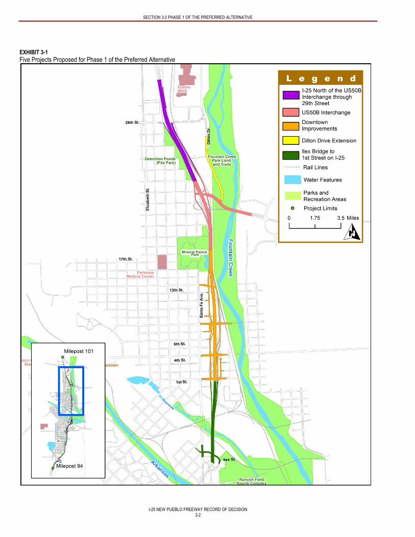
SECTION 3.0 PHASE 1 OF THE PREFERRED ALTERNATIVE
I-25 NEW PUEBLO FREEWAY RECORD OF DECISION
3-2
EXHIBIT 3-1
Five Projects Proposed for Phase 1 of the Preferred Alternative
SECTION 3.0 PHASE 1 OF THE PREFERRED ALTERNATIVE
I-25 NEW PUEBLO FREEWAY RECORD OF DECISION
3-3
The five projects proposed for Phase 1 of the Preferred Alternative and included in the amended Fiscally Constrained Plan
(PACOG, 2013) are as follows:
Ilex Bridge to 1st Street on I-25. The structurally deficient Ilex Viaduct will be replaced with two separate bridges. The project will maintain full access off Exit 98A to Ilex Street until future phases of construction. Preserving this existing interchange requires removal of the existing Ilex Street. To retain access to the northbound ramps, a portion of the ultimate Stanton Avenue extension is included to connect these ramps to Santa Fe Avenue. A minimal amount of I-25 reconstruction will be required to tie the ultimate bridge location (under the shifted I-25 alignment) back into the current I-25 alignment until subsequent phases of the project are constructed. Improvements to the southbound on-ramp from 1st Street and the northbound off-ramp to 1st Street are also included in this project, along with the viaduct replacement on I-25 between the Ilex Viaduct and the 1st Street Bridge. The Ilex Bridge to 1st Street on I-25 project will be the first project for construction to begin in the summer of 2014.
Downtown Improvements on I-25 from 13th Street to 1st Street. This construction project is the most complex area of the entire I-25 corridor and will be the most expensive of the Phase 1 projects. The project consists of a complete widening and reconstruction of I-25, construction of a split-diamond interchange between 13th Street and 1st Street with additional exit ramps near 6th Street, and construction of one-way frontage roads between the ramps.
US 50B Interchange with I-25. Planned improvements consist of reconstruction of the US 50 Bypass Interchange and the US 50B Bridge over Fountain Creek. This project also includes widening the portion of I-25 from 13th Street up to the US 50B Interchange. Due to the impacts of widening this portion, the project includes mitigation improvements to Mineral Palace Park. This mitigation could be designed and constructed prior to work on I-25 between 13th Street and US 50B.
I-25 North of the US 50B interchange through 29th Street. This project includes widening I-25 from four to six lanes, constructing frontage roads, and reconstructing interchanges from north of the US 50B interchange to milepost 101 north of 29th Street.
Dillon Drive Extension. The four-lane extension of Dillon Drive from 26th Street south to US 50B will provide north-south connectivity between US 50B and 29th Street and offers an off-highway alternative for local traffic.
The decision regarding which elements to include in Phase 1 of the Preferred Alternative was made based on funding constraints,
the project Purpose and Need, and CDOT regional priorities. The elements of Phase 1 of the Preferred Alternative were included in
the first construction phase because they address many of the existing geometric deficiencies and would provide additional
roadway capacity along the sections of I-25 with the most congestion.
3.3 TIMING OF FUTURE PHASES
Phase 2 of the Preferred Alternative, shown in Exhibit 3-2, consists of two projects that include highway widening and interchange
reconstruction from the Ilex Street bridges south to milepost 94 (South Area). This corresponds to the Central Area and South Area
as evaluated in the FEIS and as described in Section 2 – Identification of the Preferred Alternative of this document. The
alignment of I-25 would be shifted east in this phase from Ilex Street to south of Indiana Avenue. Local road improvements such as
Stanton Avenue, Locust Street, and the Santa Fe Avenue extension would also be included in Phase 2. The expected cost for this
phase is $437.5 million (2010 dollars1). Due to funding limitations, the entire dollar amount required for Phase 2 of the Preferred
Alternative may not be available at one time. Phase 2 does not necessarily need to be selected in its entirety in subsequent RODs.
The selection of Phase 2 construction elements would be determined at the time of a subsequent ROD, considering available
funding, priorities at that time, and the results of any reevaluation that may be needed.
1 Because the year of expenditure is unknown for future phases of construction, dollar amounts for Phase 2 are reported in 2010
dollars. These costs may be understated or overstated depending on economic factors such as material costs and inflation.
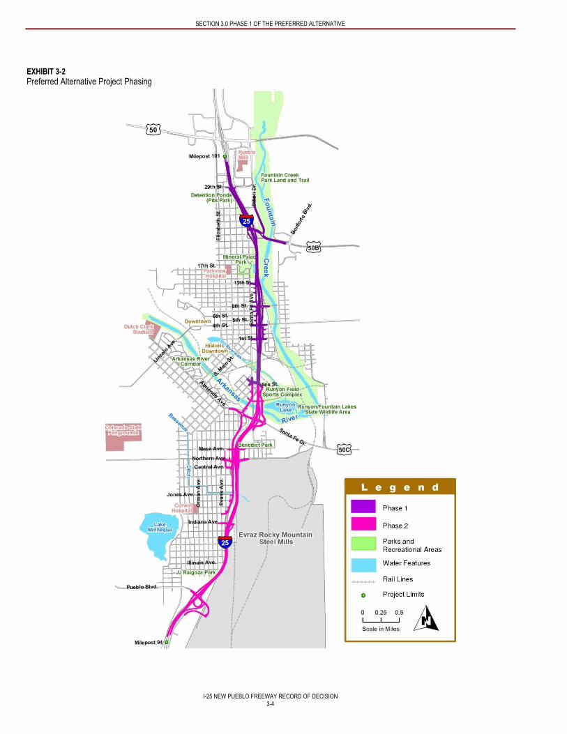
SECTION 3.0 PHASE 1 OF THE PREFERRED ALTERNATIVE
I-25 NEW PUEBLO FREEWAY RECORD OF DECISION
3-4
EXHIBIT 3-2
Preferred Alternative Project Phasing
SECTION 3.0 PHASE 1 OF THE PREFERRED ALTERNATIVE
I-25 NEW PUEBLO FREEWAY RECORD OF DECISION
3-5
The timing for implementing additional projects within future phases will be determined through the statewide planning and
programming process, which is carried out by CDOT in accordance with 23 CFR 450. Under those regulations, a project that
involves federal funding can be implemented only if the project is included in the Statewide Transportation Improvement Program
(STIP). The Colorado Department of Transportation uses Project Priority Programming Process (4P) to prioritize projects. Federal
regulations (23 CFR 450.216[a] through [o]) require all states to develop a STIP. Colorado develops its STIP in cooperation with
Metropolitan Planning Organizations (MPOs) such as PACOG, who have their own processes that include stakeholder outreach.
CDOT Engineering regions initiate 4P, conduct priority programming, and submit projects for inclusion in the STIP. The Governor,
MPOs, and the Transportation Commission have roles in approving the STIP. The final step in STIP approval is when FHWA and
the Federal Transit Administration approve the STIP.
The following general considerations will be taken into account when determining the scope of future phases or specific projects.
CDOT will consider equity issues and the need to balance the construction of improvements throughout the corridor.
Future project phases shall have independent utility in that each element would provide transportation benefits, be a reasonable expenditure even if no additional improvements are made in the area, and have logical termini.
If local agency funding or other reasonably available funding (such as private funds or other unexpected or nontraditional funding sources) becomes available, projects may be identified for inclusion in future RODs.
If state and/or federal funds become available, CDOT will select projects to include in future RODs based on the following priorities: Safety, Mobility, and Community Values.
Stakeholders have a role during the statewide planning process by providing input on project priorities. Phased project design
processes can be amended into the STIP between formal planning cycles by the Colorado Transportation Commission. As
conditions change, either through new legislation or changes in identified funding, the Colorado Transportation Commission may
include additional projects in the STIP. In reevaluating the scope of future project phases, CDOT will conduct a public information
campaign and will consult with the City and PACOG. Additionally, as each individual project goes through the final design process,
input would be sought from those local agencies affected, as is typical in CDOT project planning. Stakeholder input will also be
sought in accordance with agreements that were developed during the NEPA process and documented in the FEIS. Once the
projects have been determined for the next phase, the future ROD will identify impacts and appropriate mitigation measures that
are associated with those actions.
3.4 RESPONSIVENESS TO PURPOSE AND NEED
Phase 1 of the Preferred Alternative would incrementally contribute to addressing elements of the project Purpose and Need
(Chapter 1 - Purpose and Need of the FEIS) as described below.
Need: Address safety problems.
Straightening I-25 through downtown Pueblo and reconfiguring downtown access with a new split-diamond interchange
between 13th Street and 1st Street with additional exit ramp access at approximately 6th Street would correct the
substandard geometric deficiencies found on this section including: tight curves, steep grades, inadequate clear zones,
inadequate stopping sight distances, poor ramp design and inadequate ramp lengths, ramps that connect to local streets,
and insufficient shoulder widths. The geometric deficiencies on this section of I-25 result in fair to poor accident ratings.
Widening and reconstructing I-25 between 13th Street and the US 50B Interchange would correct tight curves, steep
grades, inadequate clear zones, inadequate stopping sight distances, and poor lane balance and ramp sequencing.
Reconstruction of the US 50B interchange would correct deficient ramp design. The deficiencies on this section of I-25
result in fair to poor accident ratings.
Reconfiguring access to 29th Street via a frontage road system would correct inadequate interchange spacing between
the 29th Street and US 50B ramps.
SECTION 3.0 PHASE 1 OF THE PREFERRED ALTERNATIVE
I-25 NEW PUEBLO FREEWAY RECORD OF DECISION
3-6
Need: Address mobility problems.
Replacing the bridges on the Ilex Street Viaduct addresses the Purpose and Need by replacing aging bridges with low
sufficiency ratings. The Ilex Street bridges have among the lowest sufficiency ratings in the 7-mile project area on I-25, and
one of the existing bridges is considered structurally deficient.
Widening I-25 from 13th Street to 1st Street would improve highway mobility by increasing capacity where the highest
future congestion in the project area is forecast.
Construction of the downtown split-diamond interchange with one way frontage roads would improve off-highway mobility
by supporting east-west connectivity through downtown.
The US 50B Interchange with I-25 reconstruction addresses the mobility element of the Purpose and Need by increasing
capacity where high future congestion is forecasted.
Construction of a pedestrian overpass near Mineral Palace Park and connection to new trails within Fountain Creek Park
Land and Mineral Palace Park will increase mobility for non-motorized users.
Widening I-25 between US 50B and 29th Street addresses the mobility element of the Purpose and Need by increasing
capacity where high future congestion is forecasted.
The four-lane extension of Dillon Drive from 26th Street south to US 50B would provide north-south connectivity between
US 50B and 29th Street and offers an off-highway alternative for local traffic, which directly supports the mobility elements
of the project Purpose and Need. Additionally, it will reduce traffic demand on I-25 parallel to Dillon Drive and construct
sidewalks along Dillon Drive, which increases mobility for non-motorized users.
The improvements proposed in Phase 1 of the Preferred Alternative would not restrict the consideration of alternatives for other
reasonably foreseeable transportation improvements. The transportation improvements to be constructed in Phase 1 of the
Preferred Alternative would have independent utility in that each element would provide transportation benefits, would be a
reasonable expenditure even if no additional improvements are made in the area, and would have logical termini. Because the FEIS
addressed transportation needs for travel on and around I-25 through Pueblo, the study considered environmental resources on a
broad scope
3.5 PHASE 1 ENVIRONMENTAL IMPACTS
The environmental impacts associated with Phase 1 of the Preferred Alternative are detailed in Chapter 3 – Affected Environment
and Environmental Consequences of the FEIS and summarized below in Exhibit 3-3.
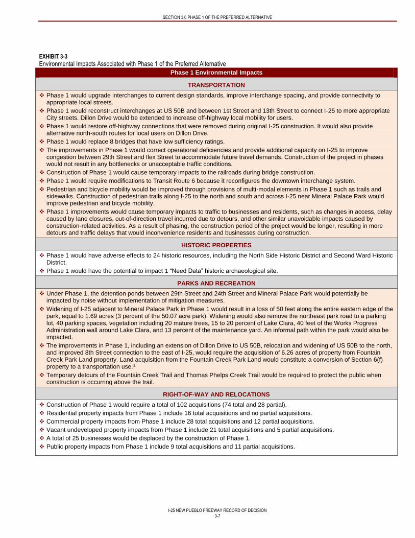
SECTION 3.0 PHASE 1 OF THE PREFERRED ALTERNATIVE
I-25 NEW PUEBLO FREEWAY RECORD OF DECISION
3-7
EXHIBIT 3-3
Environmental Impacts Associated with Phase 1 of the Preferred Alternative
Phase 1 Environmental Impacts
TRANSPORTATION
Phase 1 would upgrade interchanges to current design standards, improve interchange spacing, and provide connectivity to appropriate local streets.
Phase 1 would reconstruct interchanges at US 50B and between 1st Street and 13th Street to connect I-25 to more appropriate City streets. Dillon Drive would be extended to increase off-highway local mobility for users.
Phase 1 would restore off-highway connections that were removed during original I-25 construction. It would also provide alternative north-south routes for local users on Dillon Drive.
Phase 1 would replace 8 bridges that have low sufficiency ratings.
The improvements in Phase 1 would correct operational deficiencies and provide additional capacity on I-25 to improve congestion between 29th Street and Ilex Street to accommodate future travel demands. Construction of the project in phases would not result in any bottlenecks or unacceptable traffic conditions.
Construction of Phase 1 would cause temporary impacts to the railroads during bridge construction.
Phase 1 would require modifications to Transit Route 6 because it reconfigures the downtown interchange system.
Pedestrian and bicycle mobility would be improved through provisions of multi-modal elements in Phase 1 such as trails and sidewalks. Construction of pedestrian trails along I-25 to the north and south and across I-25 near Mineral Palace Park would improve pedestrian and bicycle mobility.
Phase 1 improvements would cause temporary impacts to traffic to businesses and residents, such as changes in access, delay caused by lane closures, out-of-direction travel incurred due to detours, and other similar unavoidable impacts caused by construction-related activities. As a result of phasing, the construction period of the project would be longer, resulting in more detours and traffic delays that would inconvenience residents and businesses during construction.
HISTORIC PROPERTIES
Phase 1 would have adverse effects to 24 historic resources, including the North Side Historic District and Second Ward Historic District.
Phase 1 would have the potential to impact 1 “Need Data” historic archaeological site.
PARKS AND RECREATION
Under Phase 1, the detention ponds between 29th Street and 24th Street and Mineral Palace Park would potentially be impacted by noise without implementation of mitigation measures.
Widening of I-25 adjacent to Mineral Palace Park in Phase 1 would result in a loss of 50 feet along the entire eastern edge of the park, equal to 1.69 acres (3 percent of the 50.07 acre park). Widening would also remove the northeast park road to a parking lot, 40 parking spaces, vegetation including 20 mature trees, 15 to 20 percent of Lake Clara, 40 feet of the Works Progress Administration wall around Lake Clara, and 13 percent of the maintenance yard. An informal path within the park would also be impacted.
The improvements in Phase 1, including an extension of Dillon Drive to US 50B, relocation and widening of US 50B to the north, and improved 8th Street connection to the east of I-25, would require the acquisition of 6.26 acres of property from Fountain Creek Park Land property. Land acquisition from the Fountain Creek Park Land would constitute a conversion of Section 6(f) property to a transportation use.1
Temporary detours of the Fountain Creek Trail and Thomas Phelps Creek Trail would be required to protect the public when construction is occurring above the trail.
RIGHT-OF-WAY AND RELOCATIONS
Construction of Phase 1 would require a total of 102 acquisitions (74 total and 28 partial).
Residential property impacts from Phase 1 include 16 total acquisitions and no partial acquisitions.
Commercial property impacts from Phase 1 include 28 total acquisitions and 12 partial acquisitions.
Vacant undeveloped property impacts from Phase 1 include 21 total acquisitions and 5 partial acquisitions.
A total of 25 businesses would be displaced by the construction of Phase 1.
Public property impacts from Phase 1 include 9 total acquisitions and 11 partial acquisitions.
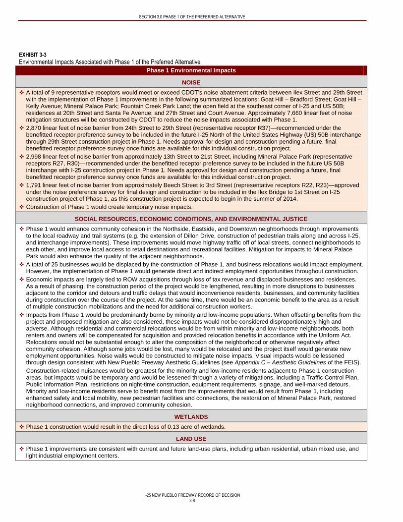
SECTION 3.0 PHASE 1 OF THE PREFERRED ALTERNATIVE
I-25 NEW PUEBLO FREEWAY RECORD OF DECISION
3-8
EXHIBIT 3-3
Environmental Impacts Associated with Phase 1 of the Preferred Alternative
Phase 1 Environmental Impacts
NOISE
A total of 9 representative receptors would meet or exceed CDOT’s noise abatement criteria between Ilex Street and 29th Street with the implementation of Phase 1 improvements in the following summarized locations: Goat Hill – Bradford Street; Goat Hill – Kelly Avenue; Mineral Palace Park; Fountain Creek Park Land; the open field at the southeast corner of I-25 and US 50B; residences at 20th Street and Santa Fe Avenue; and 27th Street and Court Avenue. Approximately 7,660 linear feet of noise mitigation structures will be constructed by CDOT to reduce the noise impacts associated with Phase 1.
2,870 linear feet of noise barrier from 24th Street to 29th Street (representative receptor R37)—recommended under the benefitted receptor preference survey to be included in the future I-25 North of the United States Highway (US) 50B interchange through 29th Street construction project in Phase 1. Needs approval for design and construction pending a future, final benefitted receptor preference survey once funds are available for this individual construction project.
2,998 linear feet of noise barrier from approximately 13th Street to 21st Street, including Mineral Palace Park (representative receptors R27, R30)—recommended under the benefitted receptor preference survey to be included in the future US 50B interchange with I-25 construction project in Phase 1. Needs approval for design and construction pending a future, final benefitted receptor preference survey once funds are available for this individual construction project.
1,791 linear feet of noise barrier from approximately Beech Street to 3rd Street (representative receptors R22, R23)—approved under the noise preference survey for final design and construction to be included in the Ilex Bridge to 1st Street on I-25 construction project of Phase 1, as this construction project is expected to begin in the summer of 2014.
Construction of Phase 1 would create temporary noise impacts.
SOCIAL RESOURCES, ECONOMIC CONDITIONS, AND ENVIRONMENTAL JUSTICE
Phase 1 would enhance community cohesion in the Northside, Eastside, and Downtown neighborhoods through improvements to the local roadway and trail systems (e.g. the extension of Dillon Drive, construction of pedestrian trails along and across I-25, and interchange improvements). These improvements would move highway traffic off of local streets, connect neighborhoods to each other, and improve local access to retail destinations and recreational facilities. Mitigation for impacts to Mineral Palace Park would also enhance the quality of the adjacent neighborhoods.
A total of 25 businesses would be displaced by the construction of Phase 1, and business relocations would impact employment. However, the implementation of Phase 1 would generate direct and indirect employment opportunities throughout construction.
Economic impacts are largely tied to ROW acquisitions through loss of tax revenue and displaced businesses and residences. As a result of phasing, the construction period of the project would be lengthened, resulting in more disruptions to businesses adjacent to the corridor and detours and traffic delays that would inconvenience residents, businesses, and community facilities during construction over the course of the project. At the same time, there would be an economic benefit to the area as a result of multiple construction mobilizations and the need for additional construction workers.
Impacts from Phase 1 would be predominantly borne by minority and low-income populations. When offsetting benefits from the project and proposed mitigation are also considered, these impacts would not be considered disproportionately high and adverse. Although residential and commercial relocations would be from within minority and low-income neighborhoods, both renters and owners will be compensated for acquisition and provided relocation benefits in accordance with the Uniform Act. Relocations would not be substantial enough to alter the composition of the neighborhood or otherwise negatively affect community cohesion. Although some jobs would be lost, many would be relocated and the project itself would generate new employment opportunities. Noise walls would be constructed to mitigate noise impacts. Visual impacts would be lessened through design consistent with New Pueblo Freeway Aesthetic Guidelines (see Appendix C – Aesthetic Guidelines of the FEIS).
Construction-related nuisances would be greatest for the minority and low-income residents adjacent to Phase 1 construction areas, but impacts would be temporary and would be lessened through a variety of mitigations, including a Traffic Control Plan, Public Information Plan, restrictions on night-time construction, equipment requirements, signage, and well-marked detours. Minority and low-income residents serve to benefit most from the improvements that would result from Phase 1, including enhanced safety and local mobility, new pedestrian facilities and connections, the restoration of Mineral Palace Park, restored neighborhood connections, and improved community cohesion.
WETLANDS
Phase 1 construction would result in the direct loss of 0.13 acre of wetlands.
LAND USE
Phase 1 improvements are consistent with current and future land-use plans, including urban residential, urban mixed use, and light industrial employment centers.
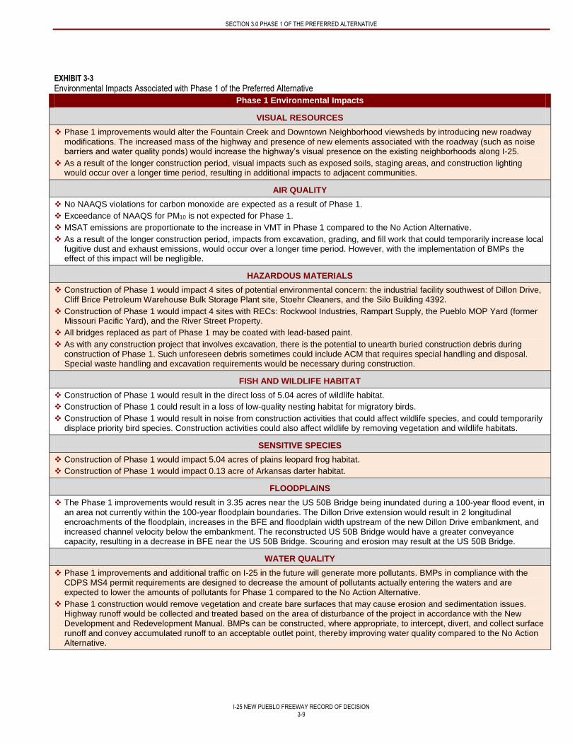
SECTION 3.0 PHASE 1 OF THE PREFERRED ALTERNATIVE
I-25 NEW PUEBLO FREEWAY RECORD OF DECISION
3-9
EXHIBIT 3-3
Environmental Impacts Associated with Phase 1 of the Preferred Alternative
Phase 1 Environmental Impacts
VISUAL RESOURCES
Phase 1 improvements would alter the Fountain Creek and Downtown Neighborhood viewsheds by introducing new roadway modifications. The increased mass of the highway and presence of new elements associated with the roadway (such as noise barriers and water quality ponds) would increase the highway’s visual presence on the existing neighborhoods along I-25.
As a result of the longer construction period, visual impacts such as exposed soils, staging areas, and construction lighting would occur over a longer time period, resulting in additional impacts to adjacent communities.
AIR QUALITY
No NAAQS violations for carbon monoxide are expected as a result of Phase 1.
Exceedance of NAAQS for PM10 is not expected for Phase 1.
MSAT emissions are proportionate to the increase in VMT in Phase 1 compared to the No Action Alternative.
As a result of the longer construction period, impacts from excavation, grading, and fill work that could temporarily increase local fugitive dust and exhaust emissions, would occur over a longer time period. However, with the implementation of BMPs the effect of this impact will be negligible.
HAZARDOUS MATERIALS
Construction of Phase 1 would impact 4 sites of potential environmental concern: the industrial facility southwest of Dillon Drive, Cliff Brice Petroleum Warehouse Bulk Storage Plant site, Stoehr Cleaners, and the Silo Building 4392.
Construction of Phase 1 would impact 4 sites with RECs: Rockwool Industries, Rampart Supply, the Pueblo MOP Yard (former Missouri Pacific Yard), and the River Street Property.
All bridges replaced as part of Phase 1 may be coated with lead-based paint.
As with any construction project that involves excavation, there is the potential to unearth buried construction debris during construction of Phase 1. Such unforeseen debris sometimes could include ACM that requires special handling and disposal. Special waste handling and excavation requirements would be necessary during construction.
FISH AND WILDLIFE HABITAT
Construction of Phase 1 would result in the direct loss of 5.04 acres of wildlife habitat.
Construction of Phase 1 could result in a loss of low-quality nesting habitat for migratory birds.
Construction of Phase 1 would result in noise from construction activities that could affect wildlife species, and could temporarily displace priority bird species. Construction activities could also affect wildlife by removing vegetation and wildlife habitats.
SENSITIVE SPECIES
Construction of Phase 1 would impact 5.04 acres of plains leopard frog habitat.
Construction of Phase 1 would impact 0.13 acre of Arkansas darter habitat.
FLOODPLAINS
The Phase 1 improvements would result in 3.35 acres near the US 50B Bridge being inundated during a 100-year flood event, in an area not currently within the 100-year floodplain boundaries. The Dillon Drive extension would result in 2 longitudinal encroachments of the floodplain, increases in the BFE and floodplain width upstream of the new Dillon Drive embankment, and increased channel velocity below the embankment. The reconstructed US 50B Bridge would have a greater conveyance capacity, resulting in a decrease in BFE near the US 50B Bridge. Scouring and erosion may result at the US 50B Bridge.
WATER QUALITY
Phase 1 improvements and additional traffic on I-25 in the future will generate more pollutants. BMPs in compliance with the CDPS MS4 permit requirements are designed to decrease the amount of pollutants actually entering the waters and are expected to lower the amounts of pollutants for Phase 1 compared to the No Action Alternative.
Phase 1 construction would remove vegetation and create bare surfaces that may cause erosion and sedimentation issues. Highway runoff would be collected and treated based on the area of disturbance of the project in accordance with the New Development and Redevelopment Manual. BMPs can be constructed, where appropriate, to intercept, divert, and collect surface runoff and convey accumulated runoff to an acceptable outlet point, thereby improving water quality compared to the No Action Alternative.
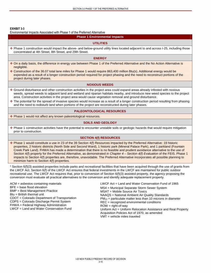
SECTION 3.0 PHASE 1 OF THE PREFERRED ALTERNATIVE
I-25 NEW PUEBLO FREEWAY RECORD OF DECISION
3-10
EXHIBIT 3-3
Environmental Impacts Associated with Phase 1 of the Preferred Alternative
Phase 1 Environmental Impacts
UTILITIES
Phase 1 construction would impact the above- and below-ground utility lines located adjacent to and across I-25, including those concentrated at 4th Street, 8th Street, and 29th Street.
ENERGY
On a daily basis, the difference in energy use between Phase 1 of the Preferred Alternative and the No Action Alternative is negligible.
Construction of the 36.07 total lane miles for Phase 1 would require 863,400 million Btu(s). Additional energy would be expended as a result of a longer construction period required for project phasing and the need to reconstruct portions of the project during later phases.
NOXIOUS WEEDS
Ground disturbance and other construction activities in the project area could expand areas already infested with noxious weeds, spread weeds to adjacent land and wetland and riparian habitats nearby, and introduce new weed species to the project area. Construction activities in the project area would cause vegetation removal and ground disturbance.
The potential for the spread of invasive species would increase as a result of a longer construction period resulting from phasing and the need to redisturb land when portions of the project are reconstructed during later phases.
PALEONTOLOGICAL RESOURCES
Phase 1 would not affect any known paleontological resources.
SOILS AND GEOLOGY
Phase 1 construction activities have the potential to encounter unstable soils or geologic hazards that would require mitigation prior to construction.
SECTION 4(f) RESOURCES
Phase 1 would constitute a use in 23 of the 39 Section 4(f) Resources impacted by the Preferred Alternative: 19 historic properties, 2 historic districts (North Side and Second Ward), 1 historic park (Mineral Palace Park), and 1 parkland (Fountain Creek Park Land). FHWA has made a determination that there is no feasible and prudent avoidance alternative to the use of Section 4(f) property for the Preferred Alternative, as demonstrated in Chapter 4 – Section 4(f) Evaluation of the FEIS. Phase 1
impacts to Section 4(f) properties are, therefore, unavoidable. The Preferred Alternative incorporates all possible planning to minimize harm to Section 4(f) properties.
1 Section 6(f)(3) assisted properties include parks and recreational facilities that have been acquired through the use of grants from the LWCF Act. Section 6(f) of the LWCF Act ensures that federal investments in the LWCF are maintained for public outdoor recreational use. The LWCF Act requires that, prior to conversion of Section 6(f)(3) assisted property, the agency proposing the conversion must evaluate all practical alternatives to the conversion and identify adequate replacement property.
ACM = asbestos containing materials BFE = base flood elevation BMP = Best Management Practice Btu = British thermal unit CDOT = Colorado Department of Transportation CDPS = Colorado Discharge Permit System FHWA = Federal Highway Administration LWCF = Land and Water Conservation Fund
LWCF Act = Land and Water Conservation Fund of 1965
MS4 = Municipal Separate Storm Sewer System MSAT = Mobile Source Air Toxics NAAQS = National Ambient Air Quality Standards PM10 = particulate matter less than 10 microns in diameter REC = recognized environmental conditions ROW = right-of-way Uniform Act = Uniform Relocation Assistance and Real Property Acquisition Policies Act of 1970, as amended VMT = vehicle miles traveled
I-25 NEW PUEBLO FREEWAY RECORD OF DECISION
4-1
4.0 SECTION 4(f)
4.1 INTRODUCTION
Section 4(f) of the Department of Transportation Act of 1966 was set forth in Title 49 United States Code (USC) Section 303 and
Title 23 USC Section 138, which states “The Secretary [of Transportation] shall not approve any program or project which
requires the use of any publicly owned land from a public park, recreation area, or wildlife and waterfowl refuge of national, state,
or local significance as determined by the federal, state, or local officials having jurisdiction thereof, or any land from an historic
site of national, State, or local significance as so determined by such officials unless 1) there is no feasible and prudent alternative
to the use of such land, and 2) such program includes all possible planning to minimize harm to such park, recreational area,
wildlife and waterfowl refuge, or historic site resulting from such use.” Section 4(f) applies to this project because the project
involves the use of multiple properties that qualify for protection under Section 4(f).
A final Section 4(f) Evaluation was included in the Chapter 4 – Section 4(f) Evaluation of the FEIS. The final Section 4(f)
Evaluation evaluated the project to determine whether there were any feasible or prudent alternatives to the use of Section 4(f)
properties and concluded that no feasible and prudent alternatives exist to the use of land from 39 Section 4(f) properties,
including 4 historic districts (78 contributing properties), 30 individual historic properties, and 5 park and recreational resources.
The FEIS identified the Preferred Alternative as the alternative with the least overall harm to Section 4(f) properties per 23 CFR
774.3(c)(1) based primarily on the ability to mitigate adverse impacts, the relative severity of the remaining harm to the property
after mitigation, the views of the officials with jurisdiction, and the degree to which the alternative meets the purpose and need for
the project. The Preferred Alternative is described in Section 2.1.1 – Final Detailed Alternatives of this document and shown in
Exhibit 2-3. As described in Section 3 – Phase 1 of the Preferred Alternative of this document, the Preferred Alternative will be
implemented in multiple phases because of funding limitations. Phase 1 consists of improvements planned from approximately
the Ilex interchange north to 29th Street and connecting the I-25 mainline improvements to those previously completed just north
of 29th Street (see Exhibit 3-1). Phase 1 is selected as the initial phase of the Preferred Alternative and is the subject of this
document. Therefore, only those Section 4(f) properties located within Phase 1 are addressed in this Section.
Following the publication of the FEIS, the I-25 bridge over the Arkansas River (Bridge K-18-AJ) was identified as potentially
eligible for the National Register of Historic Places (NRHP). Impacts to this bridge would occur in a future phase under either
Build Alternative, but would likely be greater under the Existing I-25 Alternative (where full demolition and reconstruction is
required). CDOT commits to completing an environmental evaluation of this bridge as part of the environmental clearance
documentation for any future I-25 New Pueblo Freeway ROD that includes this bridge. For any planned impact to the bridge,
CDOT has committed to completing a Section 106 analysis and consultation, as well as a Section 4(f) Evaluation. Any effects to
this bridge do not impact the decision being made in this ROD, nor does it change the conclusions of the least harm analysis or
the overall findings of the Final Section 4(f) Evaluation prepared for the project. Additionally, the decision being made in this
Phase 1 ROD does not change the opportunities to minimize or avoid the use of the bridge in the future. Additional discussion
regarding the Arkansas River Bridge is included in Section 5.3 Unresolved Issues from the FEIS and in Appendix F of this
document.
4.2 SECTION 4(f) PROPERTIES
Phase 1 of the Preferred Alternative will result in the use of 23 Section 4(f) properties, including 2 historic districts, 19 individual
historic properties, and 2 park and recreational resources as detailed in Exhibit 4-1.
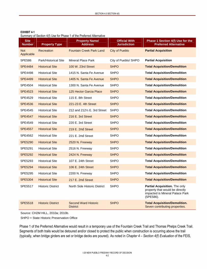
SECTION 4.0 SECTION 4(f)
I-25 NEW PUEBLO FREEWAY RECORD OF DECISION
4-2
EXHIBIT 4-1
Summary of Section 4(f) Use for Phase 1 of the Preferred Alternative
Site Number Property Type
Property Name/ Address
Official With Jurisdiction
Phase 1 Section 4(f) Use for the Preferred Alternative
Not Applicable
Recreation Fountain Creek Park Land City of Pueblo Partial Acquisition
5PE586 Park/Historical Site Mineral Place Park City of Pueblo/ SHPO Partial Acquisition
5PE4484 Historical Site 100 W. 23rd Street SHPO Total Acquisition/Demolition
5PE4498 Historical Site 1415 N. Santa Fe Avenue SHPO Total Acquisition/Demolition
5PE4499 Historical Site 1405 N. Santa Fe Avenue SHPO Total Acquisition/Demolition
5PE4504 Historical Site 1300 N. Santa Fe Avenue SHPO Total Acquisition/Demolition
5PE4523 Historical Site 125 Hector Garcia Place SHPO Total Acquisition/Demolition
5PE4529 Historical Site 115 E. 8th Street SHPO Total Acquisition/Demolition
5PE4536 Historical Site 221-23 E. 4th Street SHPO Total Acquisition/Demolition
5PE4545 Historical Site 212 and 212½ E. 3rd Street SHPO Total Acquisition/Demolition
5PE4547 Historical Site 216 E. 3rd Street SHPO Total Acquisition/Demolition
5PE4549 Historical Site 220 E. 3rd Street SHPO Total Acquisition/Demolition
5PE4557 Historical Site 219 E. 2nd Street SHPO Total Acquisition/Demolition
5PE4562 Historical Site 221 E. 2nd Street SHPO Total Acquisition/Demolition
5PE5290 Historical Site 2520 N. Freeway SHPO Total Acquisition/Demolition
5PE5291 Historical Site 2516 N. Freeway SHPO Total Acquisition/Demolition
5PE5292 Historical Site 2424 N. Freeway SHPO Total Acquisition/Demolition
5PE5293 Historical Site 107 E. 24th Street SHPO Total Acquisition/Demolition
5PE5294 Historical Site 106 E. 24th Street SHPO Total Acquisition/Demolition
5PE5295 Historical Site 2200 N. Freeway SHPO Total Acquisition/Demolition
5PE5304 Historical Site 217 E. 2nd Street SHPO Total Acquisition/Demolition
5PE5517 Historic District North Side Historic District SHPO Partial Acquisition. The only
property that would be directly impacted is Mineral Palace Park (5PE586).
5PE5518 Historic District Second Ward Historic District
SHPO Total Acquisition/Demolition.
Seven contributing properties.
Source: CH2M HILL, 2010a; 2010b.
SHPO = State Historic Preservation Office
Phase 1 of the Preferred Alternative would result in a temporary use of the Fountain Creek Trail and Thomas Phelps Creek Trail.
Segments of both trails would be detoured and/or closed to protect the public when construction is occurring above the trail
(typically, when bridge girders are set or bridge decks are poured). As noted in Chapter 4 – Section 4(f) Evaluation of the FEIS,
SECTION 4.0 SECTION 4(f)
I-25 NEW PUEBLO FREEWAY RECORD OF DECISION
4-3
detours will be developed during final design to accommodate trail users to the best extent possible – including the least amount
of out-of-direction travel and minimized trail closure periods.
Phase 1 of the Preferred Alternative will also have a de minimis impact on one individual historic property (5PE5080). This
property is officially eligible for listing on the National Register of Historic Places (NRHP) under Criterion C. Phase 1 of the
Preferred Alternative would result in the acquisition of a portion of the property that does not contribute to its historic significance.
This historic property was recommended No Adverse Effect in an April 1, 2010 submittal to the State Historic Preservation Office
(SHPO), and the SHPO concurred with this determination in correspondence dated May 17, 2010. FHWA notified the SHPO of its
intent to make a de minimis finding in correspondence dated December 2, 2010, found in Appendix B – Agency Consultation and
Coordination of the FEIS, and consulting parties were provided multiple opportunities to provide input. With the approval of this
ROD, FHWA finds the use associated with this property is de minimis.
4.3 ALL POSSIBLE PLANNING TO MINIMIZE HARM
When no prudent and feasible avoidance alternative exists, Section 4(f) requires that harm to protected resources be minimized.
Avoidance and minimization was evaluated for all of the parks, recreational resources, individual historic properties, historic
districts, and contributing properties within Phase 1 of the Preferred Alternative. In many locations, the constrained ROW made
avoiding individual properties difficult as the avoidance of one historic property would ultimately result in impacts to one or more
other properties.
The FEIS describes in detail the measures that were evaluated as part of the Preferred Alternative to minimize harm to
Section 4(f) properties. Mitigation for impacts to the Section 4(f) properties listed in Exhibit 4-1 has been included in Phase 1 of
the Preferred Alternative and is detailed in Section 8 - Mitigation of this document. Mitigation for impacts to Mineral Palace Park
has been stipulated in a March 2010 MOU between the City and CDOT (found in Appendix F – Memorandum of Understanding
Between the City of Pueblo and Colorado Department of Transportation of the FEIS). A Programmatic Agreement (Appendix E of
this document) has been developed by FHWA, CDOT, and SHPO to outline mitigation for adverse effects to historic properties.
The Programmatic Agreement reflects efforts by FHWA, CDOT, SHPO, and the consulting parties to identify specific categories of
mitigation for further consultation and investigation, including resource re-location, interpretive mitigation, and archival
documentation. Specific mitigation measures will be developed per the guidelines outlined in the Section 106 Programmatic
Agreement prior to construction of Phase 1 of the Preferred Alternative. The selected mitigation will resolve the adverse effects to
historic properties that would result from the project.
4.4 CONSULTATION AND COORDINATION
The Section 4(f) Evaluation has involved input and guidance from a variety of governmental agencies and entities. These
agencies and entities include:
SHPO
Colorado Preservation, Inc.
National Trust for Historic Preservation
Pueblo Historic Preservation Commission
City of Pueblo Planning Department
Bessemer Historical Society
Evraz Rocky Mountain Steel Mills
City of Pueblo Parks and Recreation Department
CPW
USACE
United States Department of the Interior (DOI)
SECTION 4.0 SECTION 4(f)
I-25 NEW PUEBLO FREEWAY RECORD OF DECISION
4-4
Meeting notes and letters documenting these coordination efforts are included in Appendix B – Agency Consultation and
Coordination of the FEIS.
The final Section 4(f) Evaluation approved by FHWA was published on September 13, 2012. The DOI responded on
October 24, 2013 indicating their concurrence with the Section 4(f) Evaluation, the determination that there is no feasible or
prudent alternative to the Preferred Alternative, and that all measures have been taken to minimize harm to Section 4(f) properties
(see Appendix D of this document).
I-25 NEW PUEBLO FREEWAY RECORD OF DECISION
5-1
5.0 CLARIFICATIONS TO THE FEIS AND UPDATES IN REGULATIONS
5.1 CLARIFICATIONS AND CORRECTIONS TO THE FEIS
This section includes clarifications and corrections to specific items in the FEIS. These issues were identified by comments
received during the public and agency review of the FEIS.
5.1.1 Clarifications and Corrections Related to Park and Recreational Resources
The FEIS includes dog racing as one of the many recreational opportunities within Pueblo. However, dog racing was suspended in 2008 and should not have been included in the FEIS. Pueblo Greyhound Park is now used for offices and off-track video racing. Updating this information does not change the analysis or conclusions presented in the FEIS.
The FEIS states that the detention ponds between 29th Street and 24th Street adjacent to I-25 on the west side of the highway were constructed and are owned and maintained by the City Parks and Recreation Department for the primary purpose of providing flood control and water detention. These ponds were constructed by the City and CDOT and are located within CDOT ROW and maintained by the City Parks and Recreation Department. Updating this information does not change the analysis or conclusions presented in the FEIS.
The FEIS notes that for financial reasons, the City drained half of the lake at Mineral Palace Park and sold all of the parkland south of 14th Street in the 1930s. Additional reasons for this action also include the influence of New Deal era project design and efforts to conserve potable water. Updating this information does not change the analysis or conclusions presented in the FEIS.
The FEIS notes that CDOT has committed to the construction of a new Benedict Park south of the existing park location between Mesa Avenue and Northern Avenue. To clarify this mitigation element, it is added that CDOT will coordinate with the City and the public to solicit feedback and address concerns related to the mitigation plan for Benedict Park before the design of the park is finalized. Updating this information does not change the analysis or conclusions presented in the FEIS.
5.1.2 Clarifications and Corrections related to Environmental Justice
Chapter 3 – Affected Environment and Environmental Consequences, Section 3.6 Social Resources, Economic Conditions, and
Environmental Justice, Page 3.6-17 of the FEIS states that “[t]he implementation of Best Management Practices, development of
a construction monitoring plan for particulate emissions, and other mitigation measures implemented throughout construction
would reduce the severity of these [construction-related] impacts so that remaining effects would no longer be considered high
and adverse. In addition, the long-term benefits provided by the project would likely outweigh the remaining short-term effects
during construction.”
CDOT has revised the terminology of the “construction monitoring plan” to “Construction Air Quality Control Plan” to more accurately reflect the scope of the plan.
Chapter 3 – Affected Environment and Environmental Consequences, Section 3.6 Social Resources, Economic Conditions, and
Environmental Justice, Page 3.6-18 of the FEIS states that “[t]o address the health effects of particulate emissions during
construction, CDOT will coordinate with the Colorado Department of Public Health and Environment (CDPHE) to develop a
construction monitoring plan. The monitoring plan will demonstrate how well the Preferred Alternative addresses construction-
related particulate emissions by measuring the effectiveness of mitigation measures in controlling or minimizing adverse effects.”
CDOT has revised the terminology of the “construction monitoring plan” to “Construction Air Quality Control Plan” to more accurately reflect the scope of the plan. Prior to construction, CDOT will commit to coordinate with CDPHE in the development of a plan that will minimize fugitive dust and vehicle exhaust emissions during construction.
CDOT has also replaced the last sentence describing the monitoring plan with the following: “The plan will include construction BMPs that have been demonstrated to be effective during past construction projects to reduce fugitive dust and vehicle exhaust emissions.
SECTION 5.0 CLARIFICATIONS TO THE FEIS AND UPDATES IN REGULATIONS
I-25 NEW PUEBLO FREEWAY RECORD OF DECISION
5-2
5.1.3 Clarifications and Corrections Related to Noise
The FEIS stated that noise impacts totaled seven representative receptors in the North Area under both Build Alternatives (R22, R23, R27, R28, R29, R30, and R37). The ROD updates the noise impacts in the North Area from seven to nine representative receptors (R22, R23, R24, R27, R28, R29, R30, R36, and R37). Updating this information does not change the analysis or conclusions presented in the FEIS.
The FEIS stated that noise impacts totaled five representative receptors in the Central Area under the Existing I-25 Alternative (R4, R5, R6, R18, and R19). The ROD updates the noise impacts in the Central Area under the Existing I-25 Alternative from five to seven representative receptors (R4, R5, R6, R12, R14, R18, and R19). Updating this information does not change the analysis or conclusions presented in the FEIS.
There is no change to the noise impacts in the South Area under both Build Alternatives or to the noise impacts in the Central Area under the Preferred Alternative.
5.1.4 Clarifications and Corrections Related to Mitigation Commitments
In responding to public and agency comments in Appendix B of this document, CDOT has committed to new or revised
mitigation measures which are included Exhibit 8-1 and are listed below.
CDOT, in conjunction with the City, commits to additional coordination with the public to solicit feedback regarding the size and location of the pool prior to finalizing the design and implementing the Mineral Palace Park Restoration Plan.
CDOT will coordinate controlled small-scale test excavations to determine the NRHP eligibility of the archaeological site where access is currently restricted. Testing will be conducted according to the procedures and permitting stipulations developed by the Office of Archaeology and Historic Preservation (OAHP), once CDOT acquires the property.
If cultural resources are discovered during construction, work will cease in the vicinity of the site and the CDOT Cultural Resources Manager will be contacted to evaluate the significance of the find. The Section 106 Programmatic Agreement includes stipulations for archaeological data recovery excavations and testing. The Programmatic Agreement is included in Appendix E of this document.
Prior to construction, CDOT will coordinate with CDPHE to develop a Construction Air Quality Control Plan to reduce fugitive dust and vehicle exhaust emissions during construction. The Construction Air Quality Control Plan will include construction BMPs that have been demonstrated to be effective during past construction projects to reduce fugitive dust and vehicle exhaust emissions. Contractors will be required to reduce fugitive dust emissions during construction by implementing BMPs, such as spraying or covering exposed soils, covering trucks when transporting material, minimizing mud tracking by vehicles, controlling vehicle speeds on construction access roads, and stabilizing construction entrances per CDOT M-208-1 requirements.
CDOT will obtain an Air Pollutant Emission Notice and Construction Permit for demolition and emissions from units used in construction such as asphalt plants, concrete plants, or rock crushing.
Approximately 7,660 linear feet of noise mitigation structures will be constructed by CDOT to reduce the noise impact for either of the Build Alternatives in the North Area (Phase 1). Additional noise analysis will be performed during final design to refine the final mitigation measures and dimensions. Benefitted receptors indicated their preference for the Beech Street to 3rd Street noise wall in the survey that CDOT mailed as part of the FEIS public outreach effort, and the wall will be constructed as part of the first funded construction project. Benefitted receptors indicated their preference for the Pits Park residences noise wall and North Albany Avenue/Mineral Palace Park noise wall. As individual construction projects in Phase 1 advance, CDOT will again solicit these benefitted receptors’ preferences before beginning construction. CDOT will work with the Star Nursery on a noise wall design that satisfies noise mitigation requirements and is aesthetically integrated into the neighborhood context. CDOT will work to accommodate the Star Nursery animal display to the extent possible.
During future design efforts, the location of all utilities in the I-25 corridor will be confirmed by field investigations, including locating lines below ground. During design if public or private utilities are located with the project area, the responsible utility company or agency will be contacted to avoid or minimize impacts. If relocation of utilities is required, CDOT will coordinate these efforts with the appropriate utility company or agency.
SECTION 5.0 CLARIFICATIONS TO THE FEIS AND UPDATES IN REGULATIONS
I-25 NEW PUEBLO FREEWAY RECORD OF DECISION
5-3
During Senate Bill (SB) 40 Certification, CDOT will provide the Noxious Weed Management Plan to the CPW for review prior to its completion and commits to providing the CPW the opportunity to review the project’s seed mix and re-vegetation plan.
Measures to be used in all construction areas for the Preferred Alternative to prevent the spread of noxious weeds will include the following: Contractor furnished topsoil will be free of subsoil, refuse, stumps, woody roots, rocks, brush, noxious weed seed and reproductive plant parts from current state and county weed lists, heavy clay, hard clods, toxic substances, or other material that would be detrimental to its use on the project.
Measures to be used in all construction areas for the Preferred Alternative to prevent the spread of noxious weeds will include the removal of Salt cedar and Russian olive within the construction area.
CDOT will obtain the appropriate Section 404 permit from the USACE under Section 404 of the CWA prior to construction. The policy of CDOT and FHWA is to replace all wetlands on a one-for-one basis. A wetland mitigation plan will be prepared as part of the Section 404 permitting process to mitigate for unavoidable impacts to area wetlands and waters of the United States. While there are several potential mitigation locations within the study area, CDOT and FHWA will work with USACE staff to identify the best mitigation location and concept to replace the values of the impacted wetlands. CDOT will coordinate potential wetland mitigation locations with CPW and will provide CPW with the Section 404 permit for review.
CDOT will develop Tier 1 BMPs because the project is considered a significant highway modification and the receiving waters are classified as sensitive waters (listed on 303(d) high quality use classification or existence of threatened or endangered species). Tier 1 BMPs require that the volume collected is based on the area of disturbance of the project in accordance with the New Development and Redevelopment Manual.
CDOT Specification 240 will be followed to avoid impacts to migratory birds and limit construction to avoid active nests during nesting season (April 1 through August 31).
If construction is planned during raptor nesting season (generally February 1 through July 31), nest surveys will be conducted by a qualified biologist prior to construction to determine the absence or presence of nesting migratory birds. Any unoccupied nests will be removed by CDOT in advance of construction. If an active nest is located within the limits of construction, construction will be suspended and the United States Fish and Wildlife Service (USFWS) and CPW will be contacted to develop a plan of action. Raptor nest surveys will be conducted during the appropriate nesting season to evaluate the presence of active raptor nests. Seasonal buffer zones or monitoring may be established around active nests during construction to avoid disturbance while nesting, if deemed necessary.
When construction occurs in residential areas or other noise-sensitive areas, such as parks or hospitals, temporary noise impacts from construction will be mitigated by restricting construction to daylight hours when possible and requiring contractors to use well-maintained equipment. CDOT will limit night construction in residential areas, when and where feasible. Upon request, CDOT will provide hotel vouchers for impacted residents during periods of nighttime construction.
In responding to public and agency comments in Appendix B of this document, CDOT also committed to new or revised
mitigation associated with impacts in future project phases. This mitigation commitment will be included in a future ROD.
CDOT commits to meeting with Evraz once funding for Phase 2 is identified and commits to involving Evraz in the design process. At that time, CDOT will work with Evraz to better understand the impacts associated with the Preferred Alternative and will mitigate those impacts appropriately.
CDOT evaluates mitigation commitments against performance measures to determine the enforceable and quantifiable nature of each individual commitment. In particular, a mitigation measure should have five performance measures “specific, measurable, achievable, results oriented, and timely” to be considered for inclusion in decision document. In evaluating the proposed mitigation measures against the five aforementioned performance measures, the following mitigation commitments have been deleted.
Mitigation Commitment #14: As part of its environmental ethic and policy, CDOT encourages its staff, consultants, and contractors to identify opportunities and methods to reduce the impact of projects and programs on environmental resources. This encouragement includes a commitment to allow innovative programs and flexibility in project planning, construction, and maintenance for the use of sustainable processes and materials. This may include such concepts as natural resource conservation, waste minimization, materials reuse, minimal use of native virgin materials, conservation and efficient use of
SECTION 5.0 CLARIFICATIONS TO THE FEIS AND UPDATES IN REGULATIONS
I-25 NEW PUEBLO FREEWAY RECORD OF DECISION
5-4
water and energy, air pollution prevention, preference for “green” purchasing (including recycled and minimally processed items), and preference for locally available resources. (Deleted for lack of measurable or achievable performance measures).
Mitigation Commitment #16: CDOT encourages the identification and incorporation of proven materials that are longer lasting and require less maintenance when use of such materials is consistent with CDOT’s ability to meet its primary obligations of providing a safe and efficient transportation system. Alternative materials and practices can and must meet the performance goals of CDOT construction specifications, demonstrate legitimate expenditure of public funds, and comply with all other applicable laws and regulations. (Deleted for lack of measurable or achievable performance measures).
Mitigation Commitment #37: The design of any selected alternative will comply with Executive Order (EO) 11988, “Floodplain Management.” In addition, State of Colorado drainage design standards will be applied to achieve results that will not increase or significantly change flood elevations and/or limits. (Deleted for lack of specific or results-oriented performance measures).
Mitigation Commitment #170: Based on final design, commitments will be modified or adapted as needed to mitigate for both construction and operational effects of a Preferred Alternative. A Mitigation Monitoring and Implementation Plan will be developed during final design; any commitments to mitigation will be based on a higher level of design and can be considered preliminary at this stage of design. (Deleted for lack of specific or measureable performance measures).
Additionally, the following mitigation commitments were deleted because they were repeated in several instances in Exhibit 8-1. The mitigation commitment contained within the parentheses contains the same mitigation commitment as the commitment that is being deleted and remains in Exhibit 8-1.
Mitigation Commitment #119 and 123: For City-owned properties, acquisitions would likely take place through transfer of title from the City to the State of Colorado rather than through monetary compensation. These properties would be secured for construction of the Build Alternative, and a clear delineation of responsibility and ownership would be established prior to the transfer of ownership. These properties are considered mutually beneficial, and the MOU between CDOT and the City specifies the future land exchange, ownership, and maintenance responsibilities (see Appendix F – Memorandum of Understanding Between the City of Pueblo and Colorado Department of Transportation of the FEIS). A future Intergovernmental Agreement will address ownership of excess ROWs (Mitigation Commitment #113 remains in Exhibit 8-1 for the committed to mitigation).
Mitigation Commitment #128: These properties are considered mutually beneficial, and the MOU signed between CDOT and the City specifies the future land exchange, ownership, and maintenance responsibilities (see Appendix F – Memorandum of Understanding Between the City of Pueblo and Colorado Department of Transportation of the FEIS). A future Intergovernmental Agreement will address ownership of excess ROW. Mitigation is described in more detail in Chapter 3 – Affected Environment and Environmental Consequences, Section 3.4 Right of Way and Relocation of the FEIS (Mitigation Commitment #113 remains in Exhibit 8-1 for the committed to mitigation).
Mitigation Commitment #130: Additional surveys will occur prior to final design and construction to identify additional opportunities to avoid and minimize impacts to sensitive species and habitat (Mitigation Commitment #133 remains in Exhibit 8-1 for the committed to mitigation).
Mitigation Commitment #141: Wildlife surveys will be completed prior to construction (Mitigation Commitment #138 remains in Exhibit 8-1 for the committed to mitigation).
5.2 NOISE PREFERENCE SURVEYS
According to the CDOT Noise Analysis and Abatement Guidelines (CDOT, 2011a), for noise mitigation to be implemented it must
be considered feasible and reasonable and meet the following minimum criteria described below:
Feasibility: For abatement to be feasible, both of the following criteria must be successfully met:
Barrier design must achieve a perceptible noise reduction of at least 5 dBA at one or more receptors; and
Constructability factors such as barrier height, safety, topography, drainage, utilities, and access issues must meet
normal engineering requirements and standards.
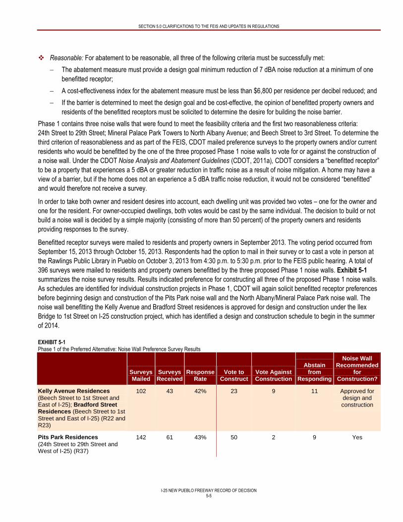
SECTION 5.0 CLARIFICATIONS TO THE FEIS AND UPDATES IN REGULATIONS
I-25 NEW PUEBLO FREEWAY RECORD OF DECISION
5-5
Reasonable: For abatement to be reasonable, all three of the following criteria must be successfully met:
The abatement measure must provide a design goal minimum reduction of 7 dBA noise reduction at a minimum of one
benefitted receptor;
A cost-effectiveness index for the abatement measure must be less than $6,800 per residence per decibel reduced; and
If the barrier is determined to meet the design goal and be cost-effective, the opinion of benefitted property owners and
residents of the benefitted receptors must be solicited to determine the desire for building the noise barrier.
Phase 1 contains three noise walls that were found to meet the feasibility criteria and the first two reasonableness criteria:
24th Street to 29th Street; Mineral Palace Park Towers to North Albany Avenue; and Beech Street to 3rd Street. To determine the
third criterion of reasonableness and as part of the FEIS, CDOT mailed preference surveys to the property owners and/or current
residents who would be benefitted by the one of the three proposed Phase 1 noise walls to vote for or against the construction of
a noise wall. Under the CDOT Noise Analysis and Abatement Guidelines (CDOT, 2011a), CDOT considers a “benefitted receptor”
to be a property that experiences a 5 dBA or greater reduction in traffic noise as a result of noise mitigation. A home may have a
view of a barrier, but if the home does not an experience a 5 dBA traffic noise reduction, it would not be considered “benefitted”
and would therefore not receive a survey.
In order to take both owner and resident desires into account, each dwelling unit was provided two votes – one for the owner and
one for the resident. For owner-occupied dwellings, both votes would be cast by the same individual. The decision to build or not
build a noise wall is decided by a simple majority (consisting of more than 50 percent) of the property owners and residents
providing responses to the survey.
Benefitted receptor surveys were mailed to residents and property owners in September 2013. The voting period occurred from
September 15, 2013 through October 15, 2013. Respondents had the option to mail in their survey or to cast a vote in person at
the Rawlings Public Library in Pueblo on October 3, 2013 from 4:30 p.m. to 5:30 p.m. prior to the FEIS public hearing. A total of
396 surveys were mailed to residents and property owners benefitted by the three proposed Phase 1 noise walls. Exhibit 5-1
summarizes the noise survey results. Results indicated preference for constructing all three of the proposed Phase 1 noise walls.
As schedules are identified for individual construction projects in Phase 1, CDOT will again solicit benefitted receptor preferences
before beginning design and construction of the Pits Park noise wall and the North Albany/Mineral Palace Park noise wall. The
noise wall benefitting the Kelly Avenue and Bradford Street residences is approved for design and construction under the Ilex
Bridge to 1st Street on I-25 construction project, which has identified a design and construction schedule to begin in the summer
of 2014.
EXHIBIT 5-1 Phase 1 of the Preferred Alternative: Noise Wall Preference Survey Results
Surveys Mailed
Surveys Received
Response Rate
Vote to Construct
Vote Against Construction
Abstain from
Responding
Noise Wall Recommended
for Construction?
Kelly Avenue Residences
(Beech Street to 1st Street and East of I-25); Bradford Street Residences (Beech Street to 1st
Street and East of I-25) (R22 and R23)
102 43 42% 23 9 11 Approved for design and construction
Pits Park Residences
(24th Street to 29th Street and West of I-25) (R37)
142 61 43% 50 2 9 Yes
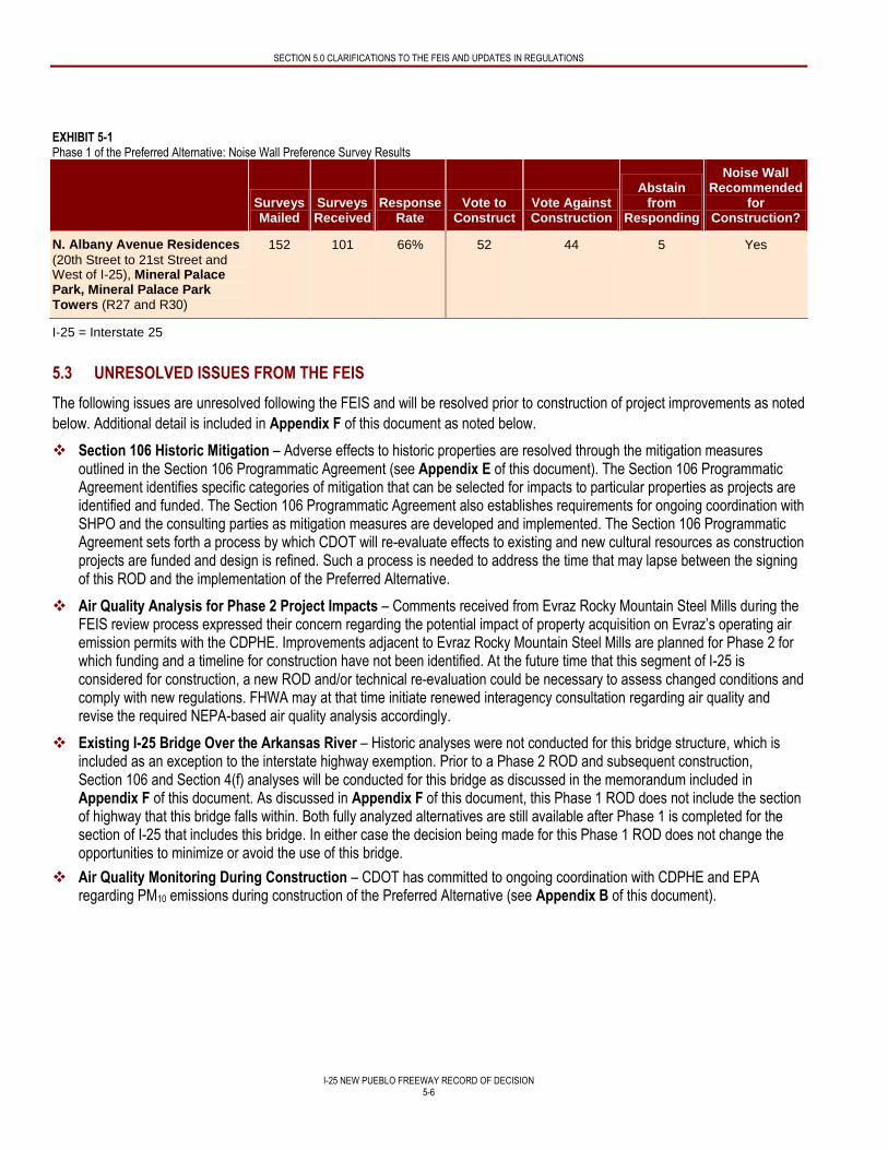
SECTION 5.0 CLARIFICATIONS TO THE FEIS AND UPDATES IN REGULATIONS
I-25 NEW PUEBLO FREEWAY RECORD OF DECISION
5-6
EXHIBIT 5-1 Phase 1 of the Preferred Alternative: Noise Wall Preference Survey Results
Surveys Mailed
Surveys Received
Response Rate
Vote to Construct
Vote Against Construction
Abstain from
Responding
Noise Wall Recommended
for Construction?
N. Albany Avenue Residences
(20th Street to 21st Street and West of I-25), Mineral Palace Park, Mineral Palace Park Towers (R27 and R30)
152 101 66% 52 44 5 Yes
I-25 = Interstate 25
5.3 UNRESOLVED ISSUES FROM THE FEIS
The following issues are unresolved following the FEIS and will be resolved prior to construction of project improvements as noted
below. Additional detail is included in Appendix F of this document as noted below.
Section 106 Historic Mitigation – Adverse effects to historic properties are resolved through the mitigation measures outlined in the Section 106 Programmatic Agreement (see Appendix E of this document). The Section 106 Programmatic Agreement identifies specific categories of mitigation that can be selected for impacts to particular properties as projects are identified and funded. The Section 106 Programmatic Agreement also establishes requirements for ongoing coordination with SHPO and the consulting parties as mitigation measures are developed and implemented. The Section 106 Programmatic Agreement sets forth a process by which CDOT will re-evaluate effects to existing and new cultural resources as construction projects are funded and design is refined. Such a process is needed to address the time that may lapse between the signing of this ROD and the implementation of the Preferred Alternative.
Air Quality Analysis for Phase 2 Project Impacts – Comments received from Evraz Rocky Mountain Steel Mills during the FEIS review process expressed their concern regarding the potential impact of property acquisition on Evraz’s operating air emission permits with the CDPHE. Improvements adjacent to Evraz Rocky Mountain Steel Mills are planned for Phase 2 for which funding and a timeline for construction have not been identified. At the future time that this segment of I-25 is considered for construction, a new ROD and/or technical re-evaluation could be necessary to assess changed conditions and comply with new regulations. FHWA may at that time initiate renewed interagency consultation regarding air quality and revise the required NEPA-based air quality analysis accordingly.
Existing I-25 Bridge Over the Arkansas River – Historic analyses were not conducted for this bridge structure, which is included as an exception to the interstate highway exemption. Prior to a Phase 2 ROD and subsequent construction, Section 106 and Section 4(f) analyses will be conducted for this bridge as discussed in the memorandum included in Appendix F of this document. As discussed in Appendix F of this document, this Phase 1 ROD does not include the section of highway that this bridge falls within. Both fully analyzed alternatives are still available after Phase 1 is completed for the section of I-25 that includes this bridge. In either case the decision being made for this Phase 1 ROD does not change the opportunities to minimize or avoid the use of this bridge.
Air Quality Monitoring During Construction – CDOT has committed to ongoing coordination with CDPHE and EPA regarding PM10 emissions during construction of the Preferred Alternative (see Appendix B of this document).
SECTION 5.0 CLARIFICATIONS TO THE FEIS AND UPDATES IN REGULATIONS
I-25 NEW PUEBLO FREEWAY RECORD OF DECISION
5-7
Hazardous Materials – As identified in the FEIS, the United States Environmental Protection Agency (EPA) is currently investigating the extent and types of contaminants associated with the Colorado Smelter Site (located near the Eiler Heights Neighborhood) to determine if the site should be listed on the National Priorities List (NPL) for cleanup. EPA will consult with the public and local agencies before making a decision to list the site on the NPL and will publish that decision in a ROD separate from the CDOT New Pueblo Freeway project. Highway improvements in this area are planned for Phase 2 for which funding and a timeline for construction have not been identified. At the future time this segment of I-25 is considered for construction, a new ROD and/or technical re-evaluation could be necessary to assess changed conditions caused by the EPA NPL listing process and any associated site cleanup activities.
I-25 NEW PUEBLO FREEWAY RECORD OF DECISION
6-1
6.0 PUBLIC COMMENTS RECEIVED ON THE FEIS
The FEIS was published by FHWA and CDOT for agency and public review on September 13, 2013. The notice of availability of
the FEIS was published in the Federal Register on September 13, 2013, indicating a 30-day review period ending on
October 15, 2013. The public was notified of the release of the FEIS and the public hearing through local newspaper
announcements, mailed notices, and the project website at: www.i25pueblo.com. An extension to this comment period was
announced in the Federal Register on October 25, 2013 in response to an EPA request (see Appendix D of this document),
which extended the comment period to October 31, 2013. The public was notified of the extension through mailed
announcements and the project website.
6.1 SUMMARY OF COMMENTS RECEIVED ON THE FEIS
Comments on the FEIS were provided in several ways; via the project website at: www.i25pueblo.com, by mail to FHWA and
CDOT Region 2, and at the public hearing for the project (held on October 3, 2013 at the Pueblo Rawlings Library). A total of
98 persons attended the public hearing. Documentation related to the public hearing is presented in Appendix C of this
document. A total of 33 comments were received on the FEIS during the public comment period. Of these, 28 were made by
individual members of the public (written or verbal), four were made by federal agencies, and the remaining comment was made
by a local organization. The CPW, USACE, DOI, and the EPA submitted comments to the lead agency. One petition was
submitted from the Star Nursery and 455 individuals signed the petition, which expressed concerns about impacts to the Star
Nursery animal display.
All comments received have been considered and responded to by FHWA and CDOT. Comments received and associated
responses are included in Appendix B of this document. Comments received on the FEIS centered on multiple subject areas; the
most common topics included:
Support for noise walls to be built in Phase 1
Concern over the future of the animal display at Star Nursery
Requesting a clarification of impacts
Requesting opportunities for ongoing public involvement
None of the comments received required a change to the Preferred Alternative, impact analysis, or mitigation measures
presented in the FEIS. Revisions and clarifications to the FEIS that have been made as a result of comments received on the
FEIS are addressed in Section 5 – Clarifications to the FEIS and Updates in Regulations of this document.
I-25 NEW PUEBLO FREEWAY RECORD OF DECISION
7-1
7.0 FEDERAL, STATE, AND LOCAL PERMITS AND APPROVALS
Transportation projects must comply with a wide range of federal and state environmental laws and regulations, permits, reviews,
notifications, consultations, and other approvals. The following discussion contains descriptions of the federal, state, or local
approvals that CDOT has received prior to the publication of this document or will seek prior to beginning construction of Phase 1
of the Preferred Alternative. FHWA and CDOT will monitor this project to ensure that permits, approvals, and mitigation measures
contained in this document (and subsequent permits) are implemented. Copies of this document will be provided to responsible
public agencies and CDOT project personnel. Commitments within this document will be implemented through the inclusion of
these measures in the construction plans for the project.
7.1 AIR QUALITY
7.1.1 Project Level Air Quality Conformity for Phase 1 of the Preferred Alternative
No project-level conformity analysis was required or performed for the project because Pueblo County, which is located within the
PACOG MPO, is currently in attainment for all of the National Ambient Air Quality Standards (NAAQS) criteria pollutants. A
conformity analysis is required to be conducted in nonattainment areas or maintenance areas to demonstrate that a project will
not increase concentrations of nonattainment pollutants and will not interfere with the area becoming in attainment.
7.1.2 Regional Air Quality Evaluation for the Preferred Alternative
No regional-level analysis was required or performed for the project because Pueblo County, which is located within the PACOG
MPO, is currently in attainment for all of the NAAQS criteria pollutants. Although not required for conformity purposes, a
qualitative analysis was performed for carbon monoxide (CO) and PM10 because these pollutants are of concern for transportation
projects. The New Pueblo Freeway project as a whole will improve intersection operations and the Preferred Alternative is not
expected to cause a violation of the CO NAAQS. Because measured PM10 levels are well below the NAAQS, PM10 is not
expected to be exceeded under the Preferred Alternative.
7.1.3 Regional Air Quality Conformity for Phase 1 of the Preferred Alternative
No regional-level analysis was required or performed for the project because Pueblo County is currently in attainment for all of the
NAAQS criteria pollutants. Phase 1 of the Preferred Alternative is incorporated into the PACOG Fiscally Constrained Plan 2035
Long Range Transportation Plan Amendment, as amended (PACOG, 2013).
7.2 SECTION 106 CONSULTATION
In compliance with Section 106 of the National Historic Preservation Act, CDOT consulted with the SHPO and consulting parties
on determinations of NRHP eligibility and effects to historic properties, per 36 CFR 800.8(c). CDOT submitted survey reports and
site forms, including eligibility determinations, to the SHPO and other Section 106 consulting parties. Concurrence on eligibility
was received from the SHPO on several dates in 2008 and 2009. Concurrence on effects to historic properties was received from
the SHPO on several dates in 2010. The FEIS provided the formal documentation for consultations on eligibility and effects for the
Build Alternatives in Appendix B, Agency Consultation and Coordination of the FEIS.
Mitigation measures for impacts to cultural resources are included in this document as Appendix E. The Programmatic
Agreement was executed between FHWA, SHPO, and CDOT in July 2012. CDOT will explore options to relocate the Steel Mill
stack and stoves; investigate an interpretive mitigation plan focused on historic properties of special significance to the history and
identity of Pueblo; and/or ensure archival documentation of properties that will be demolished.
7.3 SECTION 6(f) OF THE LAND AND WATER CONSERVATION FUND ACT
Section 6(f) of the Land and Water Conservation Fund Act of 1965 (LWCF Act) protects recreational properties that have been
purchased or improved with assistance from the Land and Water Conservation Fund (LWCF). The LWCF Act requires that prior
SECTION 7.0 FEDERAL, STATE, AND LOCAL PERMITS AND APPROVALS
I-25 NEW PUEBLO FREEWAY RECORD OF DECISION
7-2
to the conversion of Section 6(f) properties, the agency proposing the conversion must ensure that “all practical alternatives” to
converting Section 6(f) properties have been evaluated. Any proposed conversion of Section 6(f) property must be approved by
the DOI. Where no practical alternative exists to a conversion, the LWCF Act requires that replacement property be acquired for
those lands to be converted. Proposed replacement lands must be of reasonably equivalent usefulness, monetary value, and
location to those being converted.
Five properties within the project corridor were developed with LWCF grant assistance: Fountain Creek Park Land (which
includes a portion of the Fountain Creek Trail), Runyon/Fountain Lakes State Wildlife Area (which includes a trail system and the
Arkansas River Pedestrian Bridge), Runyon Field Sports Complex, Benedict Park, and JJ Raigoza Park. Of these, the Preferred
Alternative would require the conversion of LWCF assisted property from Fountain Creek Park Land (Phase 1), Runyon/Fountain
Lake State Wildlife Area (Phase 2), and Benedict Park (Phase 2). Impacts to Section 6(f) Resources and proposed mitigation
measures are detailed in Chapter 3 – Affected Environment and Environmental Consequences, Section 3.3, Parks and
Recreation of the FEIS.
CDOT met with CPW in February 2012 to discuss the New Pueblo Freeway project and its compliance with Section 6(f) of the
LWCF Act. The anticipated conversion of properties protected under Section 6(f) and the locations proposed for replacement
were discussed and agreed upon. Planning to minimize harm to parks has been an integral focus of the New Pueblo Freeway
project. The Section 6(f) properties affected by the project are also protected by Section 4(f) of the Department of Transportation
Act, which requires a thorough analysis of avoidance alternatives.
The FEIS and Section 4(f) Evaluation prepared by CDOT and FHWA was published for agency and public review on
September 13, 2013. The DOI responded on October 24, 2013 indicating their concurrence with the Section 4(f) Evaluation, and
agreement with the overall assessment of impacts to Section 6(f) Resources and proposed mitigation measures (see Appendix D
of this document). The FHWA and CDOT will continue to coordinate with the CPW and DOI during the ROW acquisition process
to determine the fair market value of the affected Section 6(f) Properties and proposed replacement sites, at which time an official
request for conversion will be submitted.
7.4 CDOT 1601 PROCESS
The CDOT Transportation Commission manages the location, design, operations and maintenance of interchanges on the state
highway system. It is the policy of the CDOT Transportation Commission that all requests for new interchanges and major
improvements to existing interchanges on the state highway system be reviewed and evaluated in a fair and consistent manner,
that sufficient information be available to make an informed decision, and that duplicative analytical, regulatory, and procedural
requirements be minimized. Proposals for new interchanges on the state highway system with a functional classification of
Interstate or Freeway (Type 1) are submitted to the Transportation Commission for action. The process outlined in CDOT Policy
Directive 1601 requires, among other things, that the interchange:
Be consistent with an approved fiscally constrained Regional Transportation Plan and Statewide Transportation Plan, and included in a Transportation Improvement Program (TIP) and/or STIP.
Be the subject of approved Intergovernmental Agreements that address the funding of the application development and review process, timeline and analytical expectations, and an Intergovernmental Agreement covering construction, operations, maintenance, and replacement of the interchange.
Have sufficient environmental, operational, and other studies performed consistent with FHWA interchange approval and NEPA requirements.
The steps in the 1601 interchange approval process include:
Step 1: 1601 Pre-Application Meeting(s)
Step 2: Initial Intergovernmental Agreement Approval
Step 3: System Level Study Preparation
SECTION 7.0 FEDERAL, STATE, AND LOCAL PERMITS AND APPROVALS
I-25 NEW PUEBLO FREEWAY RECORD OF DECISION
7-3
Step 4: System Level Study Approval
Step 5: MPO/Transportation Planning Region Board Approval
Step 6: Design and NEPA Approval Process
Step 7: Final Intergovernmental Agreement
CDOT will complete the steps in the 1601 interchange approval process prior to construction of Phase 1.
7.5 SECTION 404 PERMIT
Issuance of a Section 404 permit from the USACE is required by the Clean Water Act whenever construction projects or
maintenance activities require filling that would occur below the ordinary high water line in any body of water considered a water
of the United States (navigable waters of the United States and adjacent wetlands; all tributaries to navigable waters and adjacent
wetlands; interstate waters and their tributaries and adjacent wetlands). Formal concurrence from the USACE has been received
for the following items:
Agreement with Purpose and Need
Agreement that the Preferred Alternative appears to be the LEDPA
Preliminary Jurisdictional Determination of the Waters of the United States
CDOT will seek approval for a Section 404 individual permit prior to any construction impacting waters of the United States. The
USACE will provide concurrence on the wetland mitigation plan as part of the Section 404 permitting process.
7.6 BIOLOGICAL OPINION
FHWA and CDOT prepared a Biological Assessment in accordance with Section 7 of the Endangered Species Act. Consultation
under Section 7 of the Endangered Species Act occurs during the NEPA process if listed species or their critical habitats would be
affected by the proposed action. The six federally-listed threatened or endangered species potentially occurring in the study area
are not known to occur due to lack of suitable habitat. FHWA and CDOT find the project would have no effect on the black footed
ferret (federal endangered species), Canada lynx (federal threatened species), Preble’s meadow jumping mouse (federal
threatened species), greenback cutthroat trout (federal threatened species), whooping crane (federal endangered species), and
Mexican spotted owl (federal threatened species). Therefore, formal Section 7 consultation with the USFWS was not required.
7.7 SENATE BILL 40 CERTIFICATION
Senate Bill 40 Certification would be required by the CPW for the crossing of streams or adjacent stream banks to avoid adverse
effects to waterways, stream banks, or associated tributaries. Senate Bill 40 was legislated to protect fishing waters and to
recognize the importance of the entire stream ecosystem, including wetland and riparian areas. A SB 40 wildlife certification
application would need to be submitted to CPW 60 days before construction begins.
In following SB 40 Wildlife Certification guidelines, CDOT will notify CPW of all planned construction efforts before construction
begins, regardless of whether the action is covered by the Programmatic SB 40 certification or requires formal SB 40 certification
from CPW.
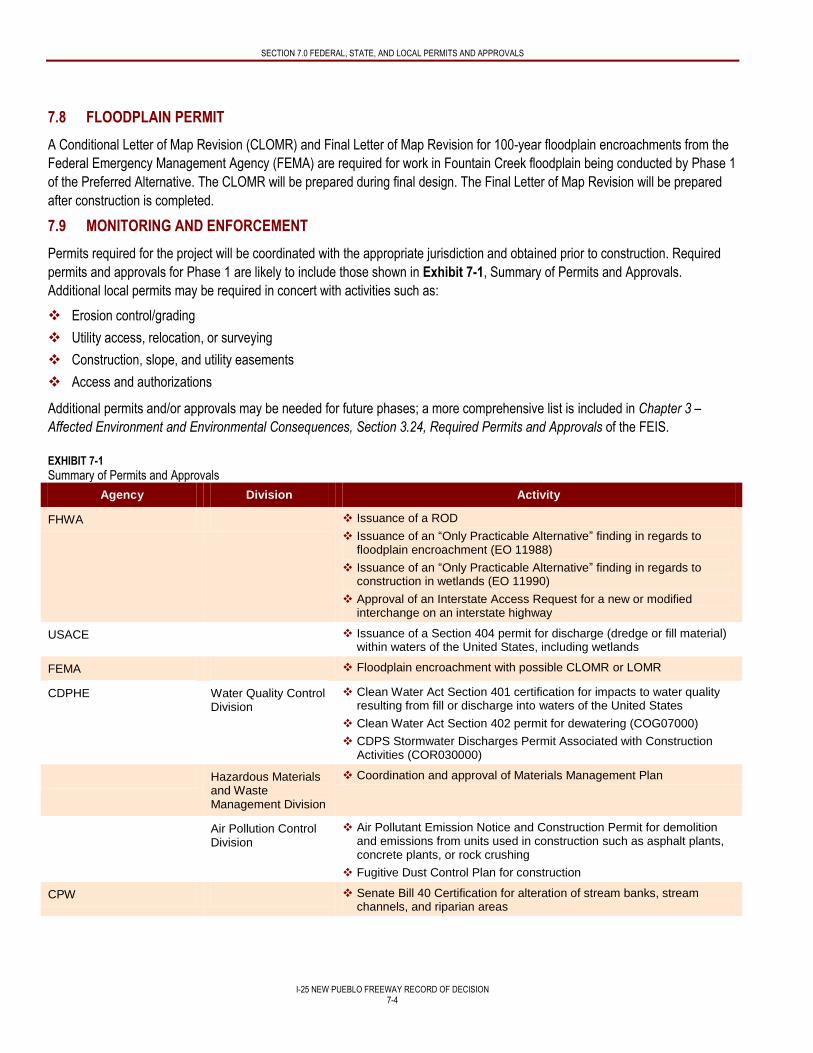
SECTION 7.0 FEDERAL, STATE, AND LOCAL PERMITS AND APPROVALS
I-25 NEW PUEBLO FREEWAY RECORD OF DECISION
7-4
7.8 FLOODPLAIN PERMIT
A Conditional Letter of Map Revision (CLOMR) and Final Letter of Map Revision for 100-year floodplain encroachments from the
Federal Emergency Management Agency (FEMA) are required for work in Fountain Creek floodplain being conducted by Phase 1
of the Preferred Alternative. The CLOMR will be prepared during final design. The Final Letter of Map Revision will be prepared
after construction is completed.
7.9 MONITORING AND ENFORCEMENT
Permits required for the project will be coordinated with the appropriate jurisdiction and obtained prior to construction. Required
permits and approvals for Phase 1 are likely to include those shown in Exhibit 7-1, Summary of Permits and Approvals.
Additional local permits may be required in concert with activities such as:
Erosion control/grading
Utility access, relocation, or surveying
Construction, slope, and utility easements
Access and authorizations
Additional permits and/or approvals may be needed for future phases; a more comprehensive list is included in Chapter 3 –
Affected Environment and Environmental Consequences, Section 3.24, Required Permits and Approvals of the FEIS.
EXHIBIT 7-1
Summary of Permits and Approvals
Agency Division Activity
FHWA Issuance of a ROD
Issuance of an “Only Practicable Alternative” finding in regards to floodplain encroachment (EO 11988)
Issuance of an “Only Practicable Alternative” finding in regards to construction in wetlands (EO 11990)
Approval of an Interstate Access Request for a new or modified interchange on an interstate highway
USACE Issuance of a Section 404 permit for discharge (dredge or fill material) within waters of the United States, including wetlands
FEMA Floodplain encroachment with possible CLOMR or LOMR
CDPHE Water Quality Control Division
Clean Water Act Section 401 certification for impacts to water quality resulting from fill or discharge into waters of the United States
Clean Water Act Section 402 permit for dewatering (COG07000)
CDPS Stormwater Discharges Permit Associated with Construction Activities (COR030000)
Hazardous Materials and Waste Management Division
Coordination and approval of Materials Management Plan
Air Pollution Control Division
Air Pollutant Emission Notice and Construction Permit for demolition and emissions from units used in construction such as asphalt plants, concrete plants, or rock crushing
Fugitive Dust Control Plan for construction
CPW Senate Bill 40 Certification for alteration of stream banks, stream channels, and riparian areas
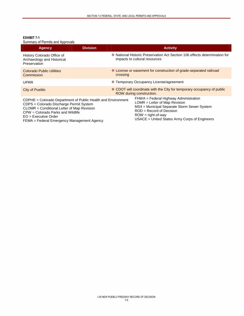
SECTION 7.0 FEDERAL, STATE, AND LOCAL PERMITS AND APPROVALS
I-25 NEW PUEBLO FREEWAY RECORD OF DECISION
7-5
EXHIBIT 7-1
Summary of Permits and Approvals
Agency Division Activity
History Colorado Office of Archaeology and Historical Preservation
National Historic Preservation Act Section 106 effects determination for impacts to cultural resources
Colorado Public Utilities Commission
License or easement for construction of grade-separated railroad crossing
UPRR Temporary Occupancy License/agreement
City of Pueblo CDOT will coordinate with the City for temporary occupancy of public ROW during construction.
CDPHE = Colorado Department of Public Health and Environment CDPS = Colorado Discharge Permit System CLOMR = Conditional Letter of Map Revision CPW = Colorado Parks and Wildlife EO = Executive Order FEMA = Federal Emergency Management Agency
FHWA = Federal Highway Administration LOMR = Letter of Map Revision MS4 = Municipal Separate Storm Sewer System ROD = Record of Decision ROW = right-of-way USACE = United States Army Corps of Engineers
I-25 NEW PUEBLO FREEWAY RECORD OF DECISION
8-1
8.0 MITIGATION
Exhibit 8-1 summarizes the impacts and associated mitigation measures identified by CDOT and FHWA to eliminate or minimize
the social and environmental impacts for Phase 1 of the Preferred Alternative. The impacts associated with Phase 1 of the
Preferred Alternative have also been summarized in Exhibit 3-2. Mitigation measures related to subsequent project phases have
been omitted from this table. As such, the mitigation commitment numbers included in Exhibit 8-1 are non-sequential. The
omitted mitigation may be found in Chapter 11 – Summary of Mitigation Measures of the FEIS.
Where appropriate, monitoring has been identified for specific resources to ensure implementation, meet permitting requirements,
and/or help identify trends and possible means for improvement. As described in this section, monitoring has been identified for
water quality (per CDOT region and statewide program/permit requirements), wetlands (per Section 404 permit requirements),
noxious weeds (during construction and re-vegetation), hazardous materials (during construction), and a number of construction
activities (as listed below). Monitoring and permitting are also discussed in Section 7 – Federal, State, and Local Permits and
Approvals of this document.
CDOT and FHWA will ensure the mitigation commitments outlined herein will be implemented as part of the project design,
construction, and post-construction monitoring. These commitments will be incorporated, as appropriate, into the construction
plans and specifications for this project. CDOT and FHWA will ensure that these commitments are implemented through review of
the project construction plans and specifications, as well as periodic inspections during construction. Inspections during
construction will involve both a review of project construction documentation and observation of construction activities. CDOT and
FHWA will monitor mitigation implementation through a combination of field reviews, pre-construction and post-construction
inspections, and post-construction monitoring, as appropriate. If mitigation is not successful or mitigation commitments are not
met, CDOT will rectify the mitigation as needed. All practicable mitigation measures have been adopted to avoid or minimize
environmental harm from the selected alternative.
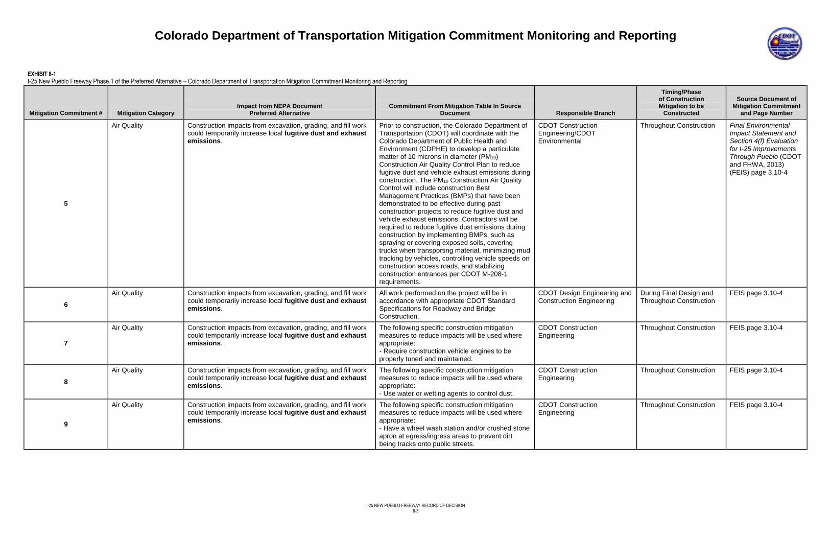
Colorado Department of Transportation Mitigation Commitment Monitoring and Reporting
I-25 NEW PUEBLO FREEWAY RECORD OF DECISION
8-3
EXHIBIT 8-1
I-25 New Pueblo Freeway Phase 1 of the Preferred Alternative – Colorado Department of Transportation Mitigation Commitment Monitoring and Reporting
Mitigation Commitment # Mitigation Category Impact from NEPA Document
Preferred Alternative Commitment From Mitigation Table In Source
Document Responsible Branch
Timing/Phase of Construction Mitigation to be
Constructed
Source Document of Mitigation Commitment
and Page Number
5
Air Quality Construction impacts from excavation, grading, and fill work could temporarily increase local fugitive dust and exhaust emissions.
Prior to construction, the Colorado Department of Transportation (CDOT) will coordinate with the Colorado Department of Public Health and Environment (CDPHE) to develop a particulate matter of 10 microns in diameter (PM10) Construction Air Quality Control Plan to reduce fugitive dust and vehicle exhaust emissions during construction. The PM10 Construction Air Quality Control will include construction Best Management Practices (BMPs) that have been demonstrated to be effective during past construction projects to reduce fugitive dust and vehicle exhaust emissions. Contractors will be required to reduce fugitive dust emissions during construction by implementing BMPs, such as spraying or covering exposed soils, covering trucks when transporting material, minimizing mud tracking by vehicles, controlling vehicle speeds on construction access roads, and stabilizing construction entrances per CDOT M-208-1 requirements.
CDOT Construction Engineering/CDOT Environmental
Throughout Construction Final Environmental Impact Statement and Section 4(f) Evaluation for I-25 Improvements Through Pueblo (CDOT and FHWA, 2013) (FEIS) page 3.10-4
6
Air Quality Construction impacts from excavation, grading, and fill work could temporarily increase local fugitive dust and exhaust emissions.
All work performed on the project will be in accordance with appropriate CDOT Standard Specifications for Roadway and Bridge Construction.
CDOT Design Engineering and Construction Engineering
During Final Design and Throughout Construction
FEIS page 3.10-4
7
Air Quality Construction impacts from excavation, grading, and fill work could temporarily increase local fugitive dust and exhaust emissions.
The following specific construction mitigation measures to reduce impacts will be used where appropriate: - Require construction vehicle engines to be properly tuned and maintained.
CDOT Construction Engineering
Throughout Construction FEIS page 3.10-4
8
Air Quality Construction impacts from excavation, grading, and fill work could temporarily increase local fugitive dust and exhaust emissions.
The following specific construction mitigation measures to reduce impacts will be used where appropriate: - Use water or wetting agents to control dust.
CDOT Construction Engineering
Throughout Construction FEIS page 3.10-4
9
Air Quality Construction impacts from excavation, grading, and fill work could temporarily increase local fugitive dust and exhaust emissions.
The following specific construction mitigation measures to reduce impacts will be used where appropriate: - Have a wheel wash station and/or crushed stone apron at egress/ingress areas to prevent dirt being tracks onto public streets.
CDOT Construction Engineering
Throughout Construction FEIS page 3.10-4
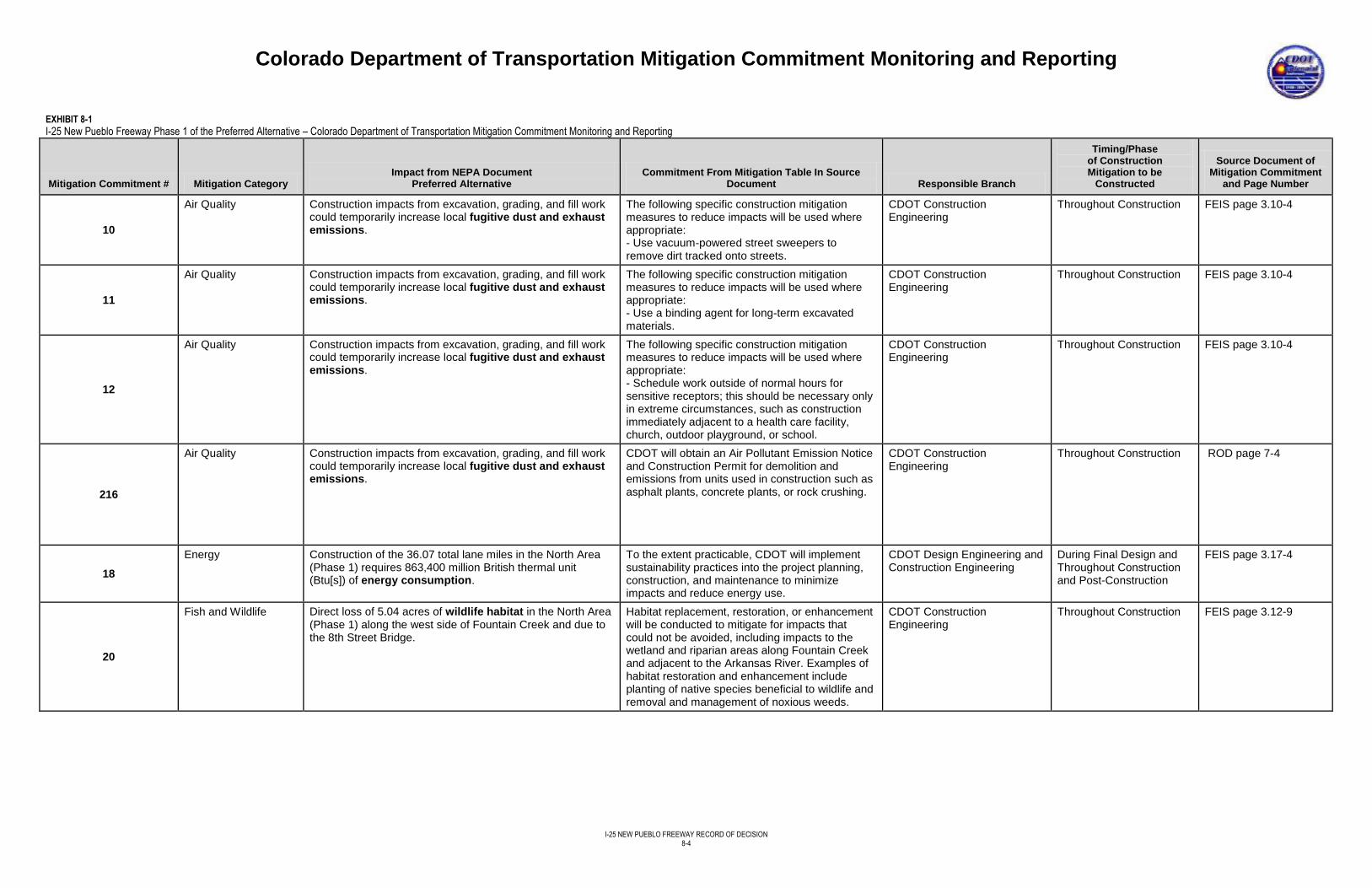
Colorado Department of Transportation Mitigation Commitment Monitoring and Reporting
I-25 NEW PUEBLO FREEWAY RECORD OF DECISION
8-4
EXHIBIT 8-1
I-25 New Pueblo Freeway Phase 1 of the Preferred Alternative – Colorado Department of Transportation Mitigation Commitment Monitoring and Reporting
Mitigation Commitment # Mitigation Category Impact from NEPA Document
Preferred Alternative Commitment From Mitigation Table In Source
Document Responsible Branch
Timing/Phase of Construction Mitigation to be
Constructed
Source Document of Mitigation Commitment
and Page Number
10
Air Quality Construction impacts from excavation, grading, and fill work could temporarily increase local fugitive dust and exhaust emissions.
The following specific construction mitigation measures to reduce impacts will be used where appropriate: - Use vacuum-powered street sweepers to remove dirt tracked onto streets.
CDOT Construction Engineering
Throughout Construction FEIS page 3.10-4
11
Air Quality Construction impacts from excavation, grading, and fill work could temporarily increase local fugitive dust and exhaust emissions.
The following specific construction mitigation measures to reduce impacts will be used where appropriate: - Use a binding agent for long-term excavated materials.
CDOT Construction Engineering
Throughout Construction FEIS page 3.10-4
12
Air Quality Construction impacts from excavation, grading, and fill work could temporarily increase local fugitive dust and exhaust emissions.
The following specific construction mitigation measures to reduce impacts will be used where appropriate: - Schedule work outside of normal hours for sensitive receptors; this should be necessary only in extreme circumstances, such as construction immediately adjacent to a health care facility, church, outdoor playground, or school.
CDOT Construction Engineering
Throughout Construction FEIS page 3.10-4
216
Air Quality Construction impacts from excavation, grading, and fill work could temporarily increase local fugitive dust and exhaust emissions.
CDOT will obtain an Air Pollutant Emission Notice and Construction Permit for demolition and emissions from units used in construction such as asphalt plants, concrete plants, or rock crushing.
CDOT Construction Engineering
Throughout Construction ROD page 7-4
18
Energy Construction of the 36.07 total lane miles in the North Area (Phase 1) requires 863,400 million British thermal unit (Btu[s]) of energy consumption.
To the extent practicable, CDOT will implement sustainability practices into the project planning, construction, and maintenance to minimize impacts and reduce energy use.
CDOT Design Engineering and Construction Engineering
During Final Design and Throughout Construction and Post-Construction
FEIS page 3.17-4
20
Fish and Wildlife Direct loss of 5.04 acres of wildlife habitat in the North Area (Phase 1) along the west side of Fountain Creek and due to the 8th Street Bridge.
Habitat replacement, restoration, or enhancement will be conducted to mitigate for impacts that could not be avoided, including impacts to the wetland and riparian areas along Fountain Creek and adjacent to the Arkansas River. Examples of habitat restoration and enhancement include planting of native species beneficial to wildlife and removal and management of noxious weeds.
CDOT Construction Engineering
Throughout Construction FEIS page 3.12-9
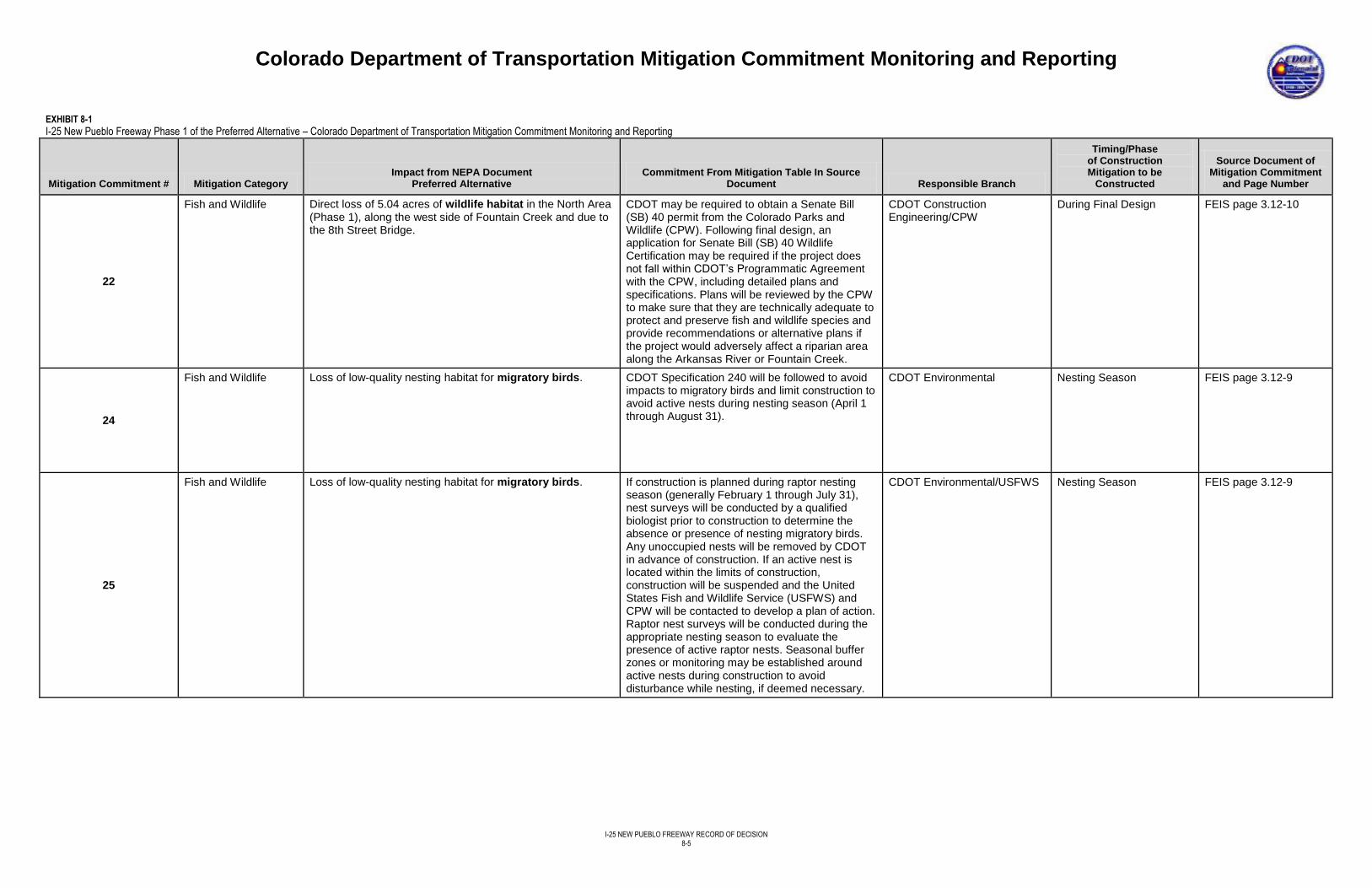
Colorado Department of Transportation Mitigation Commitment Monitoring and Reporting
I-25 NEW PUEBLO FREEWAY RECORD OF DECISION
8-5
EXHIBIT 8-1
I-25 New Pueblo Freeway Phase 1 of the Preferred Alternative – Colorado Department of Transportation Mitigation Commitment Monitoring and Reporting
Mitigation Commitment # Mitigation Category Impact from NEPA Document
Preferred Alternative Commitment From Mitigation Table In Source
Document Responsible Branch
Timing/Phase of Construction Mitigation to be
Constructed
Source Document of Mitigation Commitment
and Page Number
22
Fish and Wildlife Direct loss of 5.04 acres of wildlife habitat in the North Area (Phase 1), along the west side of Fountain Creek and due to the 8th Street Bridge.
CDOT may be required to obtain a Senate Bill (SB) 40 permit from the Colorado Parks and Wildlife (CPW). Following final design, an application for Senate Bill (SB) 40 Wildlife Certification may be required if the project does not fall within CDOT’s Programmatic Agreement with the CPW, including detailed plans and specifications. Plans will be reviewed by the CPW to make sure that they are technically adequate to protect and preserve fish and wildlife species and provide recommendations or alternative plans if the project would adversely affect a riparian area along the Arkansas River or Fountain Creek.
CDOT Construction Engineering/CPW
During Final Design FEIS page 3.12-10
24
Fish and Wildlife Loss of low-quality nesting habitat for migratory birds. CDOT Specification 240 will be followed to avoid impacts to migratory birds and limit construction to avoid active nests during nesting season (April 1 through August 31).
CDOT Environmental Nesting Season FEIS page 3.12-9
25
Fish and Wildlife Loss of low-quality nesting habitat for migratory birds. If construction is planned during raptor nesting season (generally February 1 through July 31), nest surveys will be conducted by a qualified biologist prior to construction to determine the absence or presence of nesting migratory birds. Any unoccupied nests will be removed by CDOT in advance of construction. If an active nest is located within the limits of construction, construction will be suspended and the United States Fish and Wildlife Service (USFWS) and CPW will be contacted to develop a plan of action. Raptor nest surveys will be conducted during the appropriate nesting season to evaluate the presence of active raptor nests. Seasonal buffer zones or monitoring may be established around active nests during construction to avoid disturbance while nesting, if deemed necessary.
CDOT Environmental/USFWS Nesting Season FEIS page 3.12-9
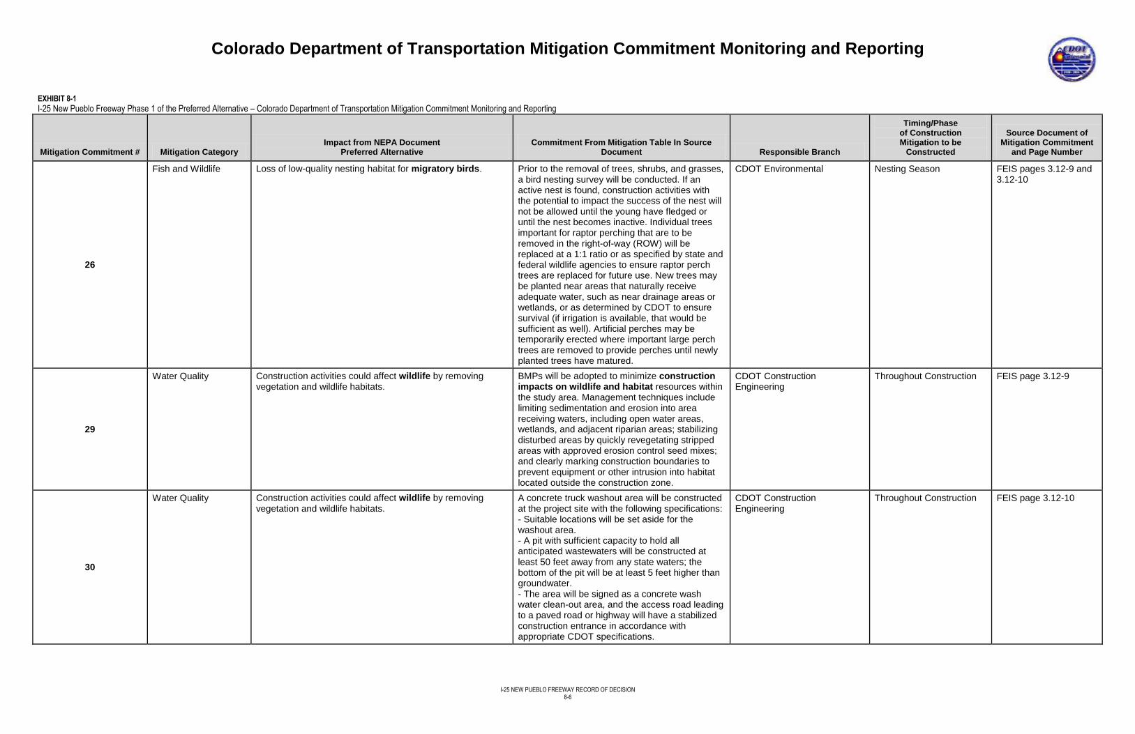
Colorado Department of Transportation Mitigation Commitment Monitoring and Reporting
I-25 NEW PUEBLO FREEWAY RECORD OF DECISION
8-6
EXHIBIT 8-1
I-25 New Pueblo Freeway Phase 1 of the Preferred Alternative – Colorado Department of Transportation Mitigation Commitment Monitoring and Reporting
Mitigation Commitment # Mitigation Category Impact from NEPA Document
Preferred Alternative Commitment From Mitigation Table In Source
Document Responsible Branch
Timing/Phase of Construction Mitigation to be
Constructed
Source Document of Mitigation Commitment
and Page Number
26
Fish and Wildlife Loss of low-quality nesting habitat for migratory birds. Prior to the removal of trees, shrubs, and grasses, a bird nesting survey will be conducted. If an active nest is found, construction activities with the potential to impact the success of the nest will not be allowed until the young have fledged or until the nest becomes inactive. Individual trees important for raptor perching that are to be removed in the right-of-way (ROW) will be replaced at a 1:1 ratio or as specified by state and federal wildlife agencies to ensure raptor perch trees are replaced for future use. New trees may be planted near areas that naturally receive adequate water, such as near drainage areas or wetlands, or as determined by CDOT to ensure survival (if irrigation is available, that would be sufficient as well). Artificial perches may be temporarily erected where important large perch trees are removed to provide perches until newly planted trees have matured.
CDOT Environmental Nesting Season FEIS pages 3.12-9 and 3.12-10
29
Water Quality Construction activities could affect wildlife by removing vegetation and wildlife habitats.
BMPs will be adopted to minimize construction impacts on wildlife and habitat resources within the study area. Management techniques include limiting sedimentation and erosion into area receiving waters, including open water areas, wetlands, and adjacent riparian areas; stabilizing disturbed areas by quickly revegetating stripped areas with approved erosion control seed mixes; and clearly marking construction boundaries to prevent equipment or other intrusion into habitat located outside the construction zone.
CDOT Construction Engineering
Throughout Construction FEIS page 3.12-9
30
Water Quality Construction activities could affect wildlife by removing vegetation and wildlife habitats.
A concrete truck washout area will be constructed at the project site with the following specifications: - Suitable locations will be set aside for the washout area. - A pit with sufficient capacity to hold all anticipated wastewaters will be constructed at least 50 feet away from any state waters; the bottom of the pit will be at least 5 feet higher than groundwater. - The area will be signed as a concrete wash water clean-out area, and the access road leading to a paved road or highway will have a stabilized construction entrance in accordance with appropriate CDOT specifications.
CDOT Construction Engineering
Throughout Construction FEIS page 3.12-10
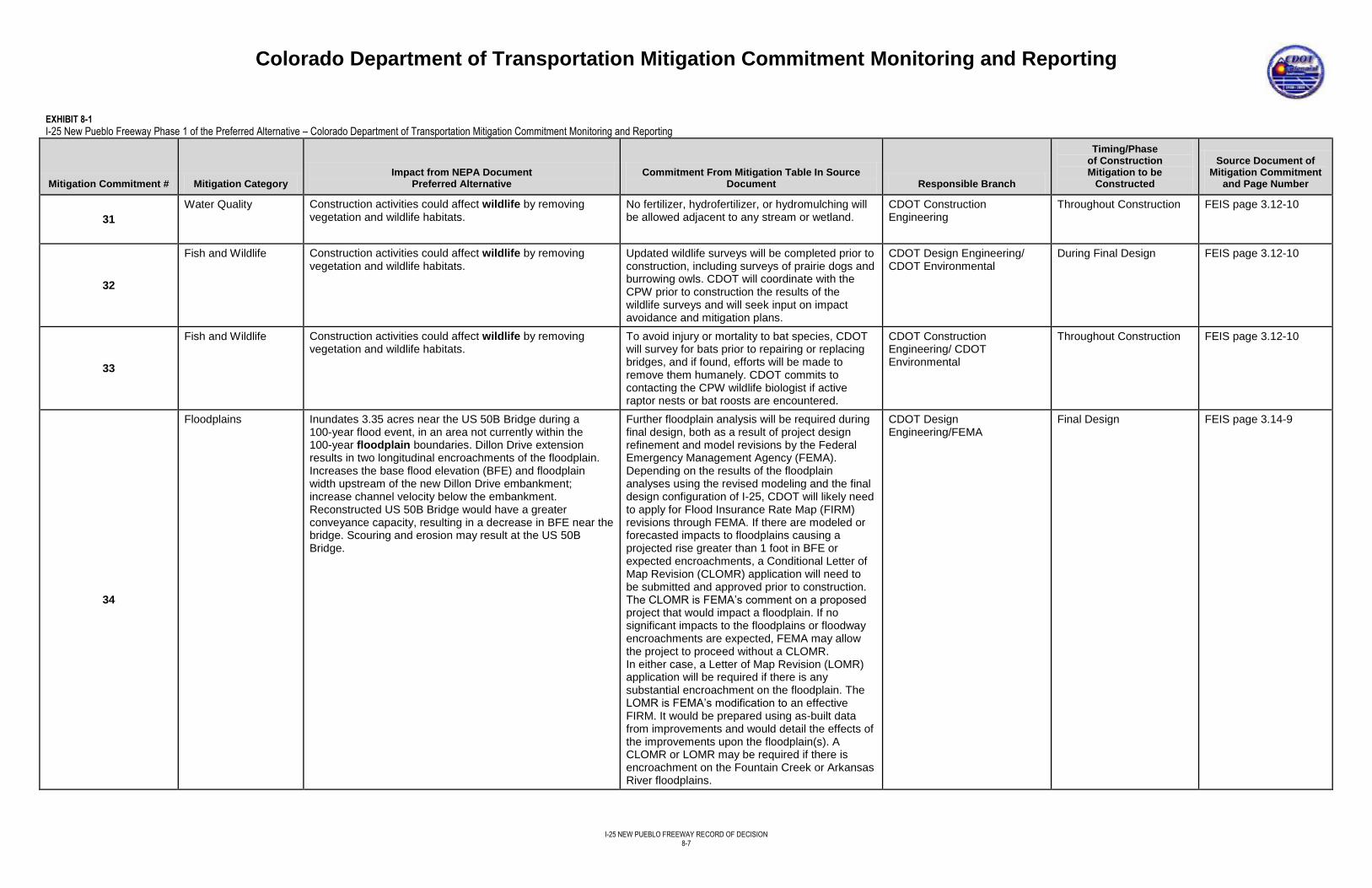
Colorado Department of Transportation Mitigation Commitment Monitoring and Reporting
I-25 NEW PUEBLO FREEWAY RECORD OF DECISION
8-7
EXHIBIT 8-1
I-25 New Pueblo Freeway Phase 1 of the Preferred Alternative – Colorado Department of Transportation Mitigation Commitment Monitoring and Reporting
Mitigation Commitment # Mitigation Category Impact from NEPA Document
Preferred Alternative Commitment From Mitigation Table In Source
Document Responsible Branch
Timing/Phase of Construction Mitigation to be
Constructed
Source Document of Mitigation Commitment
and Page Number
31
Water Quality Construction activities could affect wildlife by removing vegetation and wildlife habitats.
No fertilizer, hydrofertilizer, or hydromulching will be allowed adjacent to any stream or wetland.
CDOT Construction Engineering
Throughout Construction FEIS page 3.12-10
32
Fish and Wildlife Construction activities could affect wildlife by removing vegetation and wildlife habitats.
Updated wildlife surveys will be completed prior to construction, including surveys of prairie dogs and burrowing owls. CDOT will coordinate with the CPW prior to construction the results of the wildlife surveys and will seek input on impact avoidance and mitigation plans.
CDOT Design Engineering/ CDOT Environmental
During Final Design FEIS page 3.12-10
33
Fish and Wildlife Construction activities could affect wildlife by removing vegetation and wildlife habitats.
To avoid injury or mortality to bat species, CDOT will survey for bats prior to repairing or replacing bridges, and if found, efforts will be made to remove them humanely. CDOT commits to contacting the CPW wildlife biologist if active raptor nests or bat roosts are encountered.
CDOT Construction Engineering/ CDOT Environmental
Throughout Construction FEIS page 3.12-10
34
Floodplains Inundates 3.35 acres near the US 50B Bridge during a 100-year flood event, in an area not currently within the 100-year floodplain boundaries. Dillon Drive extension results in two longitudinal encroachments of the floodplain. Increases the base flood elevation (BFE) and floodplain width upstream of the new Dillon Drive embankment; increase channel velocity below the embankment. Reconstructed US 50B Bridge would have a greater conveyance capacity, resulting in a decrease in BFE near the bridge. Scouring and erosion may result at the US 50B Bridge.
Further floodplain analysis will be required during final design, both as a result of project design refinement and model revisions by the Federal Emergency Management Agency (FEMA). Depending on the results of the floodplain analyses using the revised modeling and the final design configuration of I-25, CDOT will likely need to apply for Flood Insurance Rate Map (FIRM) revisions through FEMA. If there are modeled or forecasted impacts to floodplains causing a projected rise greater than 1 foot in BFE or expected encroachments, a Conditional Letter of Map Revision (CLOMR) application will need to be submitted and approved prior to construction. The CLOMR is FEMA’s comment on a proposed project that would impact a floodplain. If no significant impacts to the floodplains or floodway encroachments are expected, FEMA may allow the project to proceed without a CLOMR. In either case, a Letter of Map Revision (LOMR) application will be required if there is any substantial encroachment on the floodplain. The LOMR is FEMA’s modification to an effective FIRM. It would be prepared using as-built data from improvements and would detail the effects of the improvements upon the floodplain(s). A CLOMR or LOMR may be required if there is encroachment on the Fountain Creek or Arkansas River floodplains.
CDOT Design Engineering/FEMA
Final Design FEIS page 3.14-9
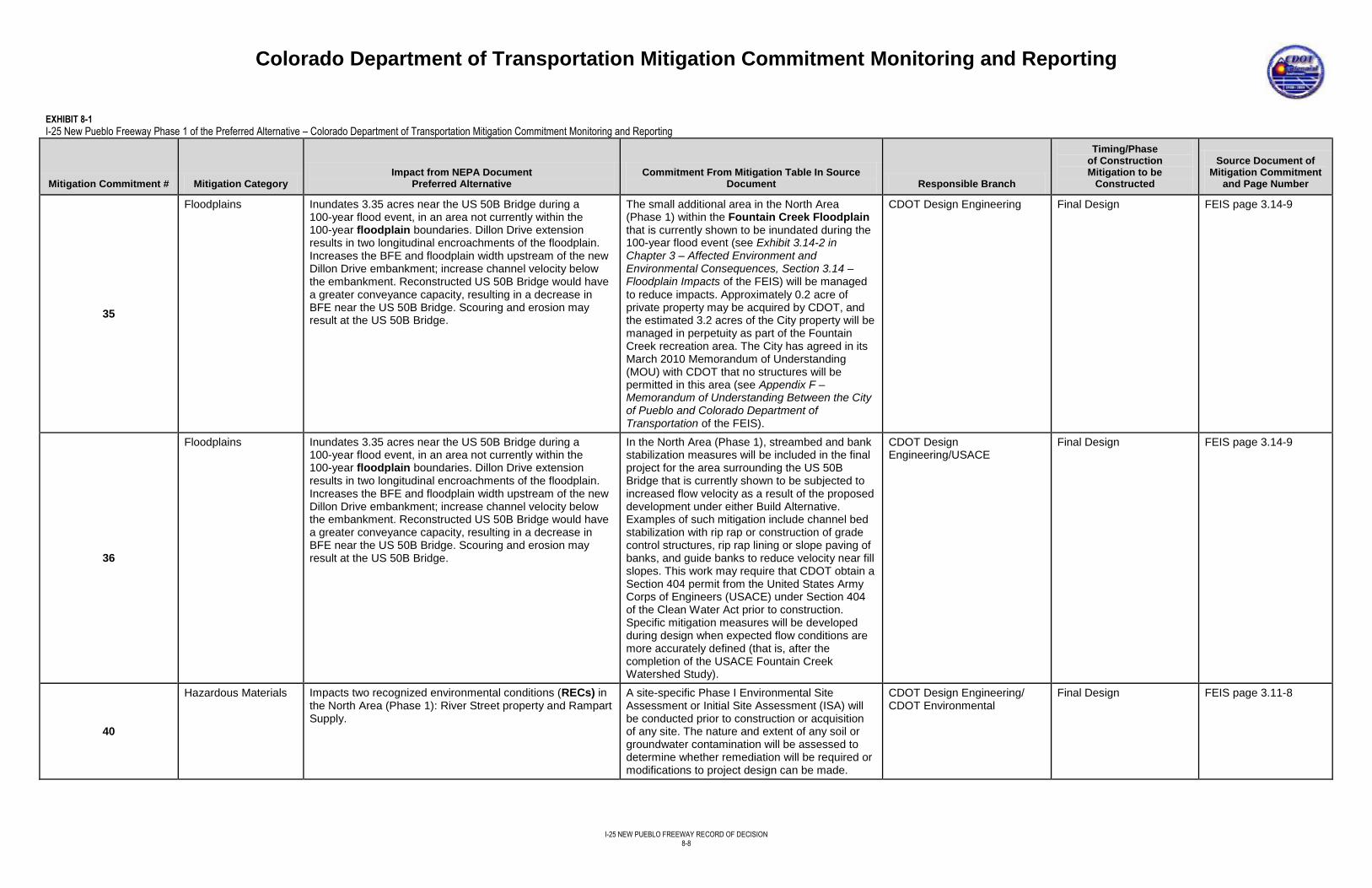
Colorado Department of Transportation Mitigation Commitment Monitoring and Reporting
I-25 NEW PUEBLO FREEWAY RECORD OF DECISION
8-8
EXHIBIT 8-1
I-25 New Pueblo Freeway Phase 1 of the Preferred Alternative – Colorado Department of Transportation Mitigation Commitment Monitoring and Reporting
Mitigation Commitment # Mitigation Category Impact from NEPA Document
Preferred Alternative Commitment From Mitigation Table In Source
Document Responsible Branch
Timing/Phase of Construction Mitigation to be
Constructed
Source Document of Mitigation Commitment
and Page Number
35
Floodplains Inundates 3.35 acres near the US 50B Bridge during a 100-year flood event, in an area not currently within the 100-year floodplain boundaries. Dillon Drive extension results in two longitudinal encroachments of the floodplain. Increases the BFE and floodplain width upstream of the new Dillon Drive embankment; increase channel velocity below the embankment. Reconstructed US 50B Bridge would have a greater conveyance capacity, resulting in a decrease in BFE near the US 50B Bridge. Scouring and erosion may result at the US 50B Bridge.
The small additional area in the North Area (Phase 1) within the Fountain Creek Floodplain that is currently shown to be inundated during the 100-year flood event (see Exhibit 3.14-2 in Chapter 3 – Affected Environment and Environmental Consequences, Section 3.14 – Floodplain Impacts of the FEIS) will be managed to reduce impacts. Approximately 0.2 acre of private property may be acquired by CDOT, and the estimated 3.2 acres of the City property will be managed in perpetuity as part of the Fountain Creek recreation area. The City has agreed in its March 2010 Memorandum of Understanding (MOU) with CDOT that no structures will be permitted in this area (see Appendix F – Memorandum of Understanding Between the City of Pueblo and Colorado Department of Transportation of the FEIS).
CDOT Design Engineering Final Design FEIS page 3.14-9
36
Floodplains Inundates 3.35 acres near the US 50B Bridge during a 100-year flood event, in an area not currently within the 100-year floodplain boundaries. Dillon Drive extension results in two longitudinal encroachments of the floodplain. Increases the BFE and floodplain width upstream of the new Dillon Drive embankment; increase channel velocity below the embankment. Reconstructed US 50B Bridge would have a greater conveyance capacity, resulting in a decrease in BFE near the US 50B Bridge. Scouring and erosion may result at the US 50B Bridge.
In the North Area (Phase 1), streambed and bank stabilization measures will be included in the final project for the area surrounding the US 50B Bridge that is currently shown to be subjected to increased flow velocity as a result of the proposed development under either Build Alternative. Examples of such mitigation include channel bed stabilization with rip rap or construction of grade control structures, rip rap lining or slope paving of banks, and guide banks to reduce velocity near fill slopes. This work may require that CDOT obtain a Section 404 permit from the United States Army Corps of Engineers (USACE) under Section 404 of the Clean Water Act prior to construction. Specific mitigation measures will be developed during design when expected flow conditions are more accurately defined (that is, after the completion of the USACE Fountain Creek Watershed Study).
CDOT Design Engineering/USACE
Final Design FEIS page 3.14-9
40
Hazardous Materials Impacts two recognized environmental conditions (RECs) in the North Area (Phase 1): River Street property and Rampart Supply.
A site-specific Phase I Environmental Site Assessment or Initial Site Assessment (ISA) will be conducted prior to construction or acquisition of any site. The nature and extent of any soil or groundwater contamination will be assessed to determine whether remediation will be required or modifications to project design can be made.
CDOT Design Engineering/ CDOT Environmental
Final Design FEIS page 3.11-8
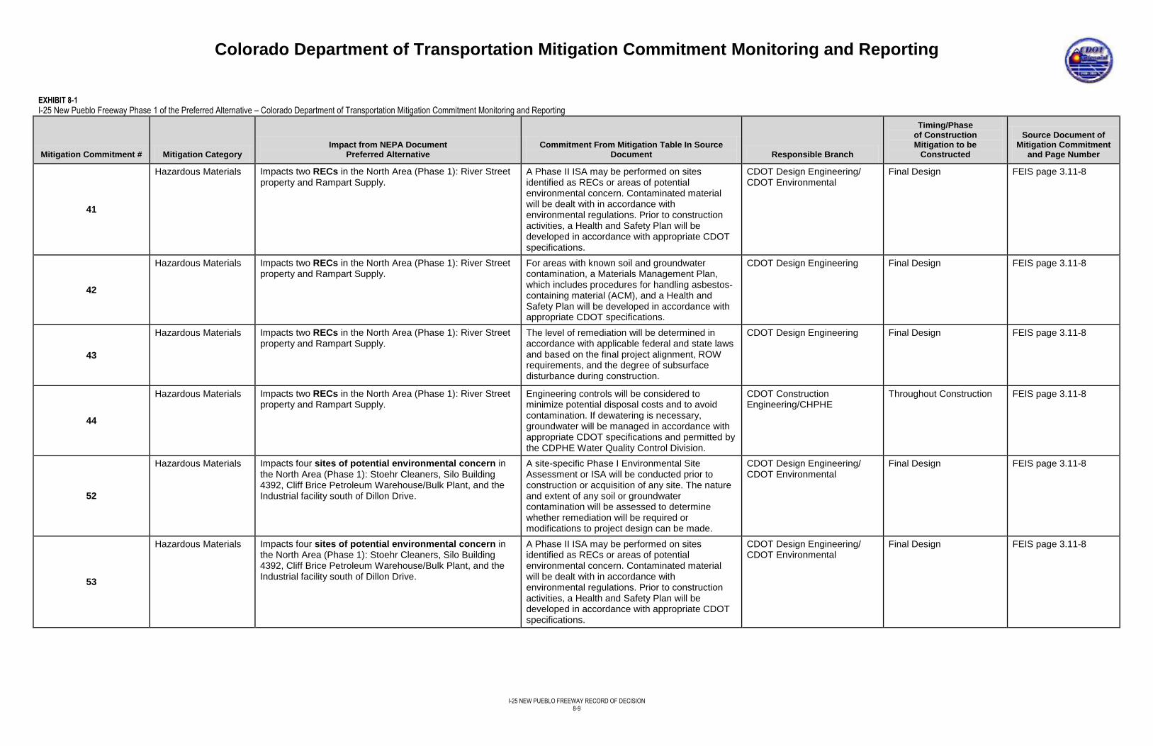
Colorado Department of Transportation Mitigation Commitment Monitoring and Reporting
I-25 NEW PUEBLO FREEWAY RECORD OF DECISION
8-9
EXHIBIT 8-1
I-25 New Pueblo Freeway Phase 1 of the Preferred Alternative – Colorado Department of Transportation Mitigation Commitment Monitoring and Reporting
Mitigation Commitment # Mitigation Category Impact from NEPA Document
Preferred Alternative Commitment From Mitigation Table In Source
Document Responsible Branch
Timing/Phase of Construction Mitigation to be
Constructed
Source Document of Mitigation Commitment
and Page Number
41
Hazardous Materials Impacts two RECs in the North Area (Phase 1): River Street property and Rampart Supply.
A Phase II ISA may be performed on sites identified as RECs or areas of potential environmental concern. Contaminated material will be dealt with in accordance with environmental regulations. Prior to construction activities, a Health and Safety Plan will be developed in accordance with appropriate CDOT specifications.
CDOT Design Engineering/ CDOT Environmental
Final Design FEIS page 3.11-8
42
Hazardous Materials Impacts two RECs in the North Area (Phase 1): River Street property and Rampart Supply.
For areas with known soil and groundwater contamination, a Materials Management Plan, which includes procedures for handling asbestos-containing material (ACM), and a Health and Safety Plan will be developed in accordance with appropriate CDOT specifications.
CDOT Design Engineering Final Design FEIS page 3.11-8
43
Hazardous Materials Impacts two RECs in the North Area (Phase 1): River Street property and Rampart Supply.
The level of remediation will be determined in accordance with applicable federal and state laws and based on the final project alignment, ROW requirements, and the degree of subsurface disturbance during construction.
CDOT Design Engineering Final Design FEIS page 3.11-8
44
Hazardous Materials Impacts two RECs in the North Area (Phase 1): River Street property and Rampart Supply.
Engineering controls will be considered to minimize potential disposal costs and to avoid contamination. If dewatering is necessary, groundwater will be managed in accordance with appropriate CDOT specifications and permitted by the CDPHE Water Quality Control Division.
CDOT Construction Engineering/CHPHE
Throughout Construction FEIS page 3.11-8
52
Hazardous Materials Impacts four sites of potential environmental concern in the North Area (Phase 1): Stoehr Cleaners, Silo Building 4392, Cliff Brice Petroleum Warehouse/Bulk Plant, and the Industrial facility south of Dillon Drive.
A site-specific Phase I Environmental Site Assessment or ISA will be conducted prior to construction or acquisition of any site. The nature and extent of any soil or groundwater contamination will be assessed to determine whether remediation will be required or modifications to project design can be made.
CDOT Design Engineering/ CDOT Environmental
Final Design
FEIS page 3.11-8
53
Hazardous Materials Impacts four sites of potential environmental concern in the North Area (Phase 1): Stoehr Cleaners, Silo Building 4392, Cliff Brice Petroleum Warehouse/Bulk Plant, and the Industrial facility south of Dillon Drive.
A Phase II ISA may be performed on sites identified as RECs or areas of potential environmental concern. Contaminated material will be dealt with in accordance with environmental regulations. Prior to construction activities, a Health and Safety Plan will be developed in accordance with appropriate CDOT specifications.
CDOT Design Engineering/ CDOT Environmental
Final Design FEIS page 3.11-8
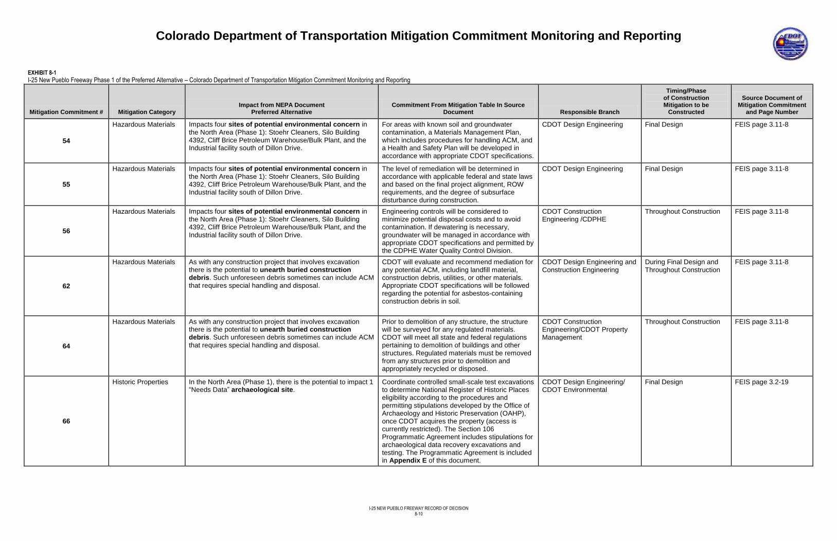
Colorado Department of Transportation Mitigation Commitment Monitoring and Reporting
I-25 NEW PUEBLO FREEWAY RECORD OF DECISION
8-10
EXHIBIT 8-1
I-25 New Pueblo Freeway Phase 1 of the Preferred Alternative – Colorado Department of Transportation Mitigation Commitment Monitoring and Reporting
Mitigation Commitment # Mitigation Category Impact from NEPA Document
Preferred Alternative Commitment From Mitigation Table In Source
Document Responsible Branch
Timing/Phase of Construction Mitigation to be
Constructed
Source Document of Mitigation Commitment
and Page Number
54
Hazardous Materials Impacts four sites of potential environmental concern in the North Area (Phase 1): Stoehr Cleaners, Silo Building 4392, Cliff Brice Petroleum Warehouse/Bulk Plant, and the Industrial facility south of Dillon Drive.
For areas with known soil and groundwater contamination, a Materials Management Plan, which includes procedures for handling ACM, and a Health and Safety Plan will be developed in accordance with appropriate CDOT specifications.
CDOT Design Engineering Final Design FEIS page 3.11-8
55
Hazardous Materials Impacts four sites of potential environmental concern in the North Area (Phase 1): Stoehr Cleaners, Silo Building 4392, Cliff Brice Petroleum Warehouse/Bulk Plant, and the Industrial facility south of Dillon Drive.
The level of remediation will be determined in accordance with applicable federal and state laws and based on the final project alignment, ROW requirements, and the degree of subsurface disturbance during construction.
CDOT Design Engineering Final Design FEIS page 3.11-8
56
Hazardous Materials Impacts four sites of potential environmental concern in the North Area (Phase 1): Stoehr Cleaners, Silo Building 4392, Cliff Brice Petroleum Warehouse/Bulk Plant, and the Industrial facility south of Dillon Drive.
Engineering controls will be considered to minimize potential disposal costs and to avoid contamination. If dewatering is necessary, groundwater will be managed in accordance with appropriate CDOT specifications and permitted by the CDPHE Water Quality Control Division.
CDOT Construction Engineering /CDPHE
Throughout Construction FEIS page 3.11-8
62
Hazardous Materials As with any construction project that involves excavation there is the potential to unearth buried construction debris. Such unforeseen debris sometimes can include ACM that requires special handling and disposal.
CDOT will evaluate and recommend mediation for any potential ACM, including landfill material, construction debris, utilities, or other materials. Appropriate CDOT specifications will be followed regarding the potential for asbestos-containing construction debris in soil.
CDOT Design Engineering and Construction Engineering
During Final Design and Throughout Construction
FEIS page 3.11-8
64
Hazardous Materials As with any construction project that involves excavation there is the potential to unearth buried construction debris. Such unforeseen debris sometimes can include ACM that requires special handling and disposal.
Prior to demolition of any structure, the structure will be surveyed for any regulated materials. CDOT will meet all state and federal regulations pertaining to demolition of buildings and other structures. Regulated materials must be removed from any structures prior to demolition and appropriately recycled or disposed.
CDOT Construction Engineering/CDOT Property Management
Throughout Construction FEIS page 3.11-8
66
Historic Properties In the North Area (Phase 1), there is the potential to impact 1 “Needs Data” archaeological site.
Coordinate controlled small-scale test excavations to determine National Register of Historic Places eligibility according to the procedures and permitting stipulations developed by the Office of Archaeology and Historic Preservation (OAHP), once CDOT acquires the property (access is currently restricted). The Section 106 Programmatic Agreement includes stipulations for archaeological data recovery excavations and testing. The Programmatic Agreement is included in Appendix E of this document.
CDOT Design Engineering/ CDOT Environmental
Final Design
FEIS page 3.2-19
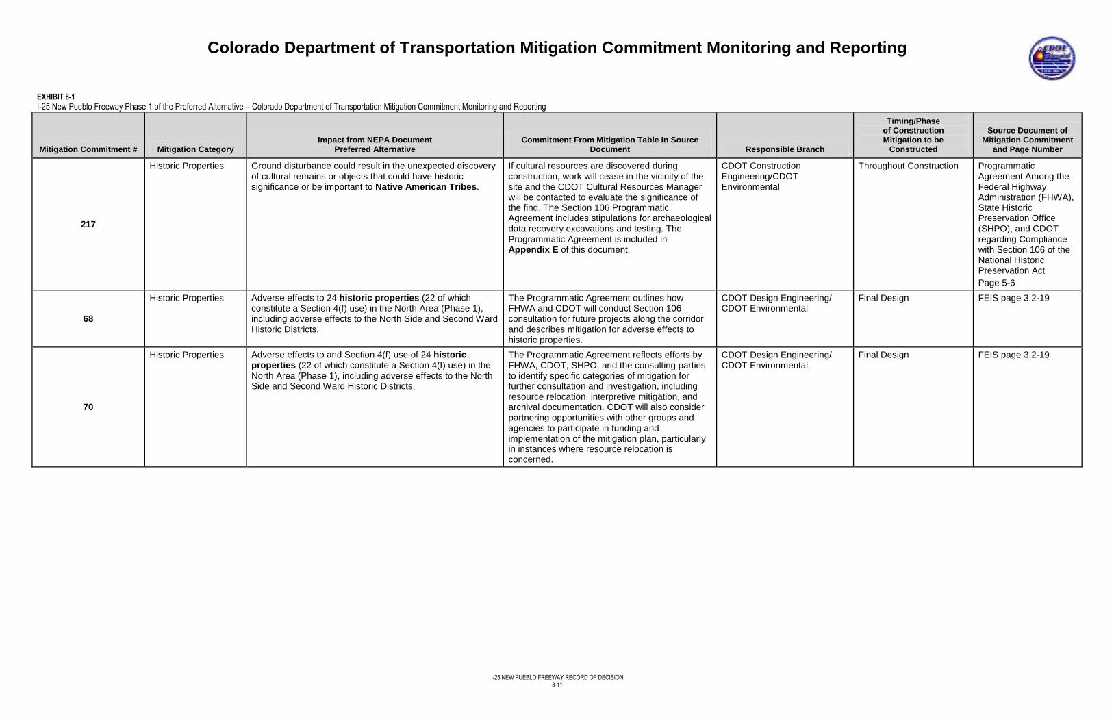
Colorado Department of Transportation Mitigation Commitment Monitoring and Reporting
I-25 NEW PUEBLO FREEWAY RECORD OF DECISION
8-11
EXHIBIT 8-1
I-25 New Pueblo Freeway Phase 1 of the Preferred Alternative – Colorado Department of Transportation Mitigation Commitment Monitoring and Reporting
Mitigation Commitment # Mitigation Category Impact from NEPA Document
Preferred Alternative Commitment From Mitigation Table In Source
Document Responsible Branch
Timing/Phase of Construction Mitigation to be
Constructed
Source Document of Mitigation Commitment
and Page Number
217
Historic Properties Ground disturbance could result in the unexpected discovery of cultural remains or objects that could have historic significance or be important to Native American Tribes.
If cultural resources are discovered during construction, work will cease in the vicinity of the site and the CDOT Cultural Resources Manager will be contacted to evaluate the significance of the find. The Section 106 Programmatic Agreement includes stipulations for archaeological data recovery excavations and testing. The Programmatic Agreement is included in Appendix E of this document.
CDOT Construction Engineering/CDOT Environmental
Throughout Construction Programmatic Agreement Among the Federal Highway Administration (FHWA), State Historic Preservation Office (SHPO), and CDOT regarding Compliance with Section 106 of the National Historic Preservation Act
Page 5-6
68
Historic Properties Adverse effects to 24 historic properties (22 of which constitute a Section 4(f) use) in the North Area (Phase 1), including adverse effects to the North Side and Second Ward Historic Districts.
The Programmatic Agreement outlines how FHWA and CDOT will conduct Section 106 consultation for future projects along the corridor and describes mitigation for adverse effects to historic properties.
CDOT Design Engineering/ CDOT Environmental
Final Design FEIS page 3.2-19
70
Historic Properties Adverse effects to and Section 4(f) use of 24 historic properties (22 of which constitute a Section 4(f) use) in the North Area (Phase 1), including adverse effects to the North Side and Second Ward Historic Districts.
The Programmatic Agreement reflects efforts by FHWA, CDOT, SHPO, and the consulting parties to identify specific categories of mitigation for further consultation and investigation, including resource relocation, interpretive mitigation, and archival documentation. CDOT will also consider partnering opportunities with other groups and agencies to participate in funding and implementation of the mitigation plan, particularly in instances where resource relocation is concerned.
CDOT Design Engineering/ CDOT Environmental
Final Design FEIS page 3.2-19
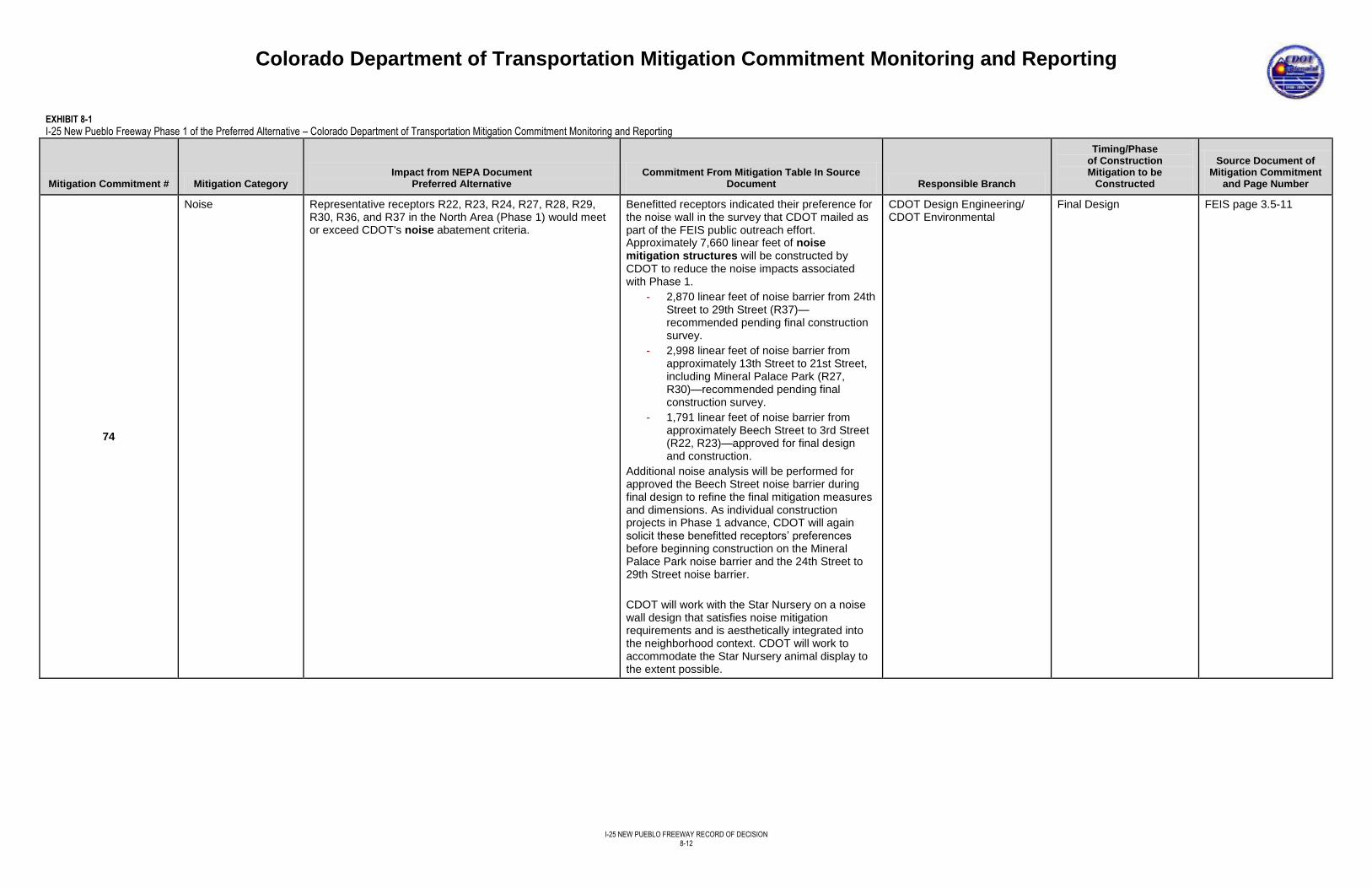
Colorado Department of Transportation Mitigation Commitment Monitoring and Reporting
I-25 NEW PUEBLO FREEWAY RECORD OF DECISION
8-12
EXHIBIT 8-1
I-25 New Pueblo Freeway Phase 1 of the Preferred Alternative – Colorado Department of Transportation Mitigation Commitment Monitoring and Reporting
Mitigation Commitment # Mitigation Category Impact from NEPA Document
Preferred Alternative Commitment From Mitigation Table In Source
Document Responsible Branch
Timing/Phase of Construction Mitigation to be
Constructed
Source Document of Mitigation Commitment
and Page Number
74
Noise Representative receptors R22, R23, R24, R27, R28, R29, R30, R36, and R37 in the North Area (Phase 1) would meet or exceed CDOT's noise abatement criteria.
Benefitted receptors indicated their preference for the noise wall in the survey that CDOT mailed as part of the FEIS public outreach effort. Approximately 7,660 linear feet of noise mitigation structures will be constructed by CDOT to reduce the noise impacts associated with Phase 1.
- 2,870 linear feet of noise barrier from 24th Street to 29th Street (R37)—recommended pending final construction survey.
- 2,998 linear feet of noise barrier from approximately 13th Street to 21st Street, including Mineral Palace Park (R27, R30)—recommended pending final construction survey.
- 1,791 linear feet of noise barrier from approximately Beech Street to 3rd Street (R22, R23)—approved for final design and construction.
Additional noise analysis will be performed for approved the Beech Street noise barrier during final design to refine the final mitigation measures and dimensions. As individual construction projects in Phase 1 advance, CDOT will again solicit these benefitted receptors’ preferences before beginning construction on the Mineral Palace Park noise barrier and the 24th Street to 29th Street noise barrier.
CDOT will work with the Star Nursery on a noise wall design that satisfies noise mitigation requirements and is aesthetically integrated into the neighborhood context. CDOT will work to accommodate the Star Nursery animal display to the extent possible.
CDOT Design Engineering/ CDOT Environmental
Final Design FEIS page 3.5-11
Colorado Department of Transportation Mitigation Commitment Monitoring and Reporting
I-25 NEW PUEBLO FREEWAY RECORD OF DECISION
8-13
EXHIBIT 8-1
I-25 New Pueblo Freeway Phase 1 of the Preferred Alternative – Colorado Department of Transportation Mitigation Commitment Monitoring and Reporting
Mitigation Commitment # Mitigation Category Impact from NEPA Document
Preferred Alternative Commitment From Mitigation Table In Source
Document Responsible Branch
Timing/Phase of Construction Mitigation to be
Constructed
Source Document of Mitigation Commitment
and Page Number
77
Noise Construction would create temporary noise impacts. When construction occurs in residential areas or other noise-sensitive areas, such as parks or hospitals, temporary noise impacts from construction will be mitigated by restricting construction to daylight hours when possible and requiring contractors to use well-maintained equipment. CDOT will limit night construction in residential areas, when and where feasible. Upon request, CDOT will provide hotel vouchers for impacted residents during periods of nighttime construction.
CDOT Construction Engineering
Throughout Construction FEIS page 3.5-11
78
Noxious Weeds Ground disturbance and other construction activities in the project area may expand areas already infested with noxious weeds, may spread weeds to adjacent land as well as to wetland and riparian habitats nearby, and may introduce new weed species to the project area. Construction activities in the project area will cause a lot of vegetation removal and ground disturbance.
Prior to the start of construction activities, CDOT will conduct a new noxious weed survey to map existing weeds requiring mandatory eradication and management to stop their spreading within the project area and will develop and implement a Noxious Weed Management Plan that incorporates herbicides, mechanical removal, and potential biological controls in accordance with the Colorado Noxious Weed Act to control and prevent weed infestation and spread. During SB 40 Certification, CDOT will provide the Noxious Weed Management Plan to the CPW for review prior to its completion and commits to providing the CPW the opportunity to review the project’s seed mix and re-vegetation plan.
CDOT Design Engineering/ CDOT Environmental
During Final Design FEIS page 3.18-3
79
Noxious Weeds Ground disturbance and other construction activities in the project area may expand areas already infested with noxious weeds, may spread weeds to adjacent land as well as to wetland and riparian habitats nearby, and may introduce new weed species to the project area. Construction activities in the project area will cause a lot of vegetation removal and ground disturbance.
Measures to be used in all construction areas for the Preferred Alternative to prevent the spread of noxious weeds will include the following: - Noxious weeds observed in and near the construction area at the onset of construction will be treated with herbicides or physically removed to prevent seed distribution into areas disturbed during construction. In sensitive areas, such as wetland and riparian areas, appropriate control measures will be implemented according to the Noxious Weed Management Plan.
CDOT Construction Engineering
Throughout Construction
FEIS page 3.18-3
Colorado Department of Transportation Mitigation Commitment Monitoring and Reporting
I-25 NEW PUEBLO FREEWAY RECORD OF DECISION
8-14
EXHIBIT 8-1
I-25 New Pueblo Freeway Phase 1 of the Preferred Alternative – Colorado Department of Transportation Mitigation Commitment Monitoring and Reporting
Mitigation Commitment # Mitigation Category Impact from NEPA Document
Preferred Alternative Commitment From Mitigation Table In Source
Document Responsible Branch
Timing/Phase of Construction Mitigation to be
Constructed
Source Document of Mitigation Commitment
and Page Number
80
Noxious Weeds Ground disturbance and other construction activities in the project area may expand areas already infested with noxious weeds, may spread weeds to adjacent land as well as to wetland and riparian habitats nearby, and may introduce new weed species to the project area. Construction activities in the project area will cause a lot of vegetation removal and ground disturbance.
Measures to be used in all construction areas for the Preferred Alternative to prevent the spread of noxious weeds will include the following:
- In accordance with CDOT Standard Specifications for Roadway and Bridge Construction (207.02) (CDOT, 2011b), Contractor furnished topsoil will be free of subsoil, refuse, stumps, woody roots, rocks, brush, noxious weed seed and reproductive plant parts from current state and county weed lists, heavy clay, hard clods, toxic substances, or other material that would be detrimental to its use on the project.
CDOT Construction Engineering
Throughout Construction
FEIS page 3.18-3
81
Noxious Weeds Ground disturbance and other construction activities in the project area may expand areas already infested with noxious weeds, may spread weeds to adjacent land as well as to wetland and riparian habitats nearby, and may introduce new weed species to the project area. Construction activities in the project area will cause a lot of vegetation removal and ground disturbance.
Measures to be used in all construction areas for the Preferred Alternative to prevent the spread of noxious weeds will include the following: - Disturbed areas will be reclaimed immediately after the completion of construction and seeded with an appropriate native seed mix. Seed will be certified for purity and weed seed content. In areas that cannot be immediately seeded due to the time of year, mulch and mulch tackifier (to hold the mulch in place) will be used for temporary erosion control until seeding can occur.
CDOT Construction Engineering
Throughout Construction
FEIS page 3.18-3
82
Noxious Weeds Ground disturbance and other construction activities in the project area may expand areas already infested with noxious weeds, may spread weeds to adjacent land as well as to wetland and riparian habitats nearby, and may introduce new weed species to the project area. Construction activities in the project area will cause a lot of vegetation removal and ground disturbance.
Measures to be used in all construction areas for the Preferred Alternative to prevent the spread of noxious weeds will include the following: - Certified weed-free seed mixes and certified weed-free straw bales for use in stormwater management and erosion control will be specified in the plan sets for construction. Native grasses and forbs will be used on all CDOT ROW for revegetation purposes.
CDOT Construction Engineering
Throughout Construction
FEIS page 3.18-3
83
Noxious Weeds Ground disturbance and other construction activities in the project area may expand areas already infested with noxious weeds, may spread weeds to adjacent land as well as to wetland and riparian habitats nearby, and may introduce new weed species to the project area. Construction activities in the project area will cause a lot of vegetation removal and ground disturbance.
Measures to be used in all construction areas for the Preferred Alternative to prevent the spread of noxious weeds will include the following: - All construction equipment will be thoroughly washed before being brought into the project area or being moved between construction sites to avoid introducing undesirable plants and noxious weeds. Equipment will remain on designated roadways and will stay out of weed-infested areas until they are treated.
CDOT Construction Engineering
Throughout Construction
FEIS page 3.18-3
Colorado Department of Transportation Mitigation Commitment Monitoring and Reporting
I-25 NEW PUEBLO FREEWAY RECORD OF DECISION
8-15
EXHIBIT 8-1
I-25 New Pueblo Freeway Phase 1 of the Preferred Alternative – Colorado Department of Transportation Mitigation Commitment Monitoring and Reporting
Mitigation Commitment # Mitigation Category Impact from NEPA Document
Preferred Alternative Commitment From Mitigation Table In Source
Document Responsible Branch
Timing/Phase of Construction Mitigation to be
Constructed
Source Document of Mitigation Commitment
and Page Number
84
Noxious Weeds Ground disturbance and other construction activities in the project area may expand areas already infested with noxious weeds, may spread weeds to adjacent land as well as to wetland and riparian habitats nearby, and may introduce new weed species to the project area. Construction activities in the project area will cause a lot of vegetation removal and ground disturbance.
Measures to be used in all construction areas for the Preferred Alternative to prevent the spread of noxious weeds will include the following: - To the extent possible, weed management efforts will be coordinated with local jurisdictional agencies and adjacent landowners.
CDOT Construction Engineering
Throughout Construction
FEIS page 3.18-3
215
Noxious Weeds BMPs will be used to control erosion and sedimentation within wetlands or waters of the United States during construction.
Salt cedar and Russian olive within the construction area will be removed.
CDOT Construction Engineering
Throughout Construction FEIS page 3.7-9
85
Noxious Weeds Ground disturbance and other construction activities in the project area may expand areas already infested with noxious weeds, may spread weeds to adjacent land as well as to wetland and riparian habitats nearby, and may introduce new weed species to the project area. Construction activities in the project area will cause a lot of vegetation removal and ground disturbance.
After construction, CDOT ROW will be managed through standard CDOT maintenance operations.
CDOT Maintenance and Operations
Post-Construction FEIS page 3.18-3
86
Paleontology Neither of the Build Alternatives would impact any known significant paleontological resources.
If any fossils or other paleontological resources are found anywhere in the project area during construction, construction activities will be halted and the CDOT staff paleontologist will be contacted immediately to assess the significance of the find and make further recommendations.
CDOT Construction Engineering/CDOT Environmental
Throughout Construction FEIS page 3.19-1
87
Parks and Recreation Without mitigation, the Detention Ponds between 29th Street and 24th Street would experience an increase in noise. No direct impacts would occur.
To alleviate potential noise impacts from I-25, CDOT will place two noise barriers between 29th Street and 24th Street on the west side parallel to I-25, starting at the north end and ending in the south. The barrier will mitigate potential noise from traffic on I-25 after roadway improvements have been made.
CDOT Design Engineering Final Design
FEIS page 3.3-20
89
Parks and Recreation Widening of I-25 adjacent to Mineral Palace Park would result in a loss of 50 feet along the entire eastern edge of the park, equal to 1.69 acres (3 percent of the 50.07 acre park) and result in a Section 4(f) use. Widening would also remove the northeast park road to a parking lot, 40 parking spaces, vegetation including: 20 mature trees, 15 to 20 percent of Lake Clara, 40 feet of the Works Progress Administration wall around Lake Clara, and 13 percent of the maintenance yard. An informal path within the park would also be impacted. Without mitigation, the park would experience an increase in noise.
The key components of the Mineral Palace Park Restoration Plan include: - Increase the size of Mineral Palace Park to 52.38 acres. Land will be added adjacent to the park, south to 13th Street, and north to the US 50B loop. Implementation of the mitigation measures for the park have been stipulated in a MOU between the City and CDOT (see Appendix F – Memorandum of Understanding Between the City of Pueblo and Colorado Department of Transportation of the FEIS). The MOU contains commitments from CDOT to
CDOT Design Engineering/ CDOT Environmental
Final Design FEIS pages 3.3-20, 3.3-21, 3.3-22, and 3.3-23
Colorado Department of Transportation Mitigation Commitment Monitoring and Reporting
I-25 NEW PUEBLO FREEWAY RECORD OF DECISION
8-16
EXHIBIT 8-1
I-25 New Pueblo Freeway Phase 1 of the Preferred Alternative – Colorado Department of Transportation Mitigation Commitment Monitoring and Reporting
Mitigation Commitment # Mitigation Category Impact from NEPA Document
Preferred Alternative Commitment From Mitigation Table In Source
Document Responsible Branch
Timing/Phase of Construction Mitigation to be
Constructed
Source Document of Mitigation Commitment
and Page Number
89 (Cont.)
construct park improvements and lays out the responsibilities of the City to accept ownership and maintenance responsibility for those improvements, once completed. - Relocate the swimming pool. The existing swimming pool will be moved out of the existing park. Although the pool is an important community amenity, it is not consistent with the historical uses of the park. CDOT, in conjunction with the City, will coordinate with the public to solicit feedback regarding the design and location of the new pool prior to the final design and implementation of the restoration plan. - Add new parking. The parking that will be lost as a result of the I-25 widening will be replaced with new parking lots that include several physically disabled parking spaces in both the southern and northern parts of the park. - Construct a pedestrian bridge. A pedestrian bridge will be constructed over I-25 to connect Mineral Palace Park to the Fountain Creek Park Land. - Add mitigation structures. Noise mitigation features (such as walls and earthen berms) will be added to reduce noise from I-25. - Add vegetation. Vegetation will be planted along proposed sound walls and berms to soften views into and out of the park. More trees will be planted in the park as a nursery crop to replace the current shade trees that are on the decline because they are well over 100 years old. - Enlarge Lake Clara. Lake Clara will be expanded so that it will function as a healthy lake with adequate space. - Move the maintenance facility. The maintenance facility will be relocated out of the park to add more usable parkland. - Construct a fountain. A fountain will be constructed to look similar to the original fountain that was once present in the park and was removed prior to the development of this project. - Relocate activities. Facilities and activity areas that are not noise sensitive will be moved closer to the highway. - Increase access to the park and within the park. Increased access will be provided by adding additional trail connections and improving the internal roadway and walk systems within the
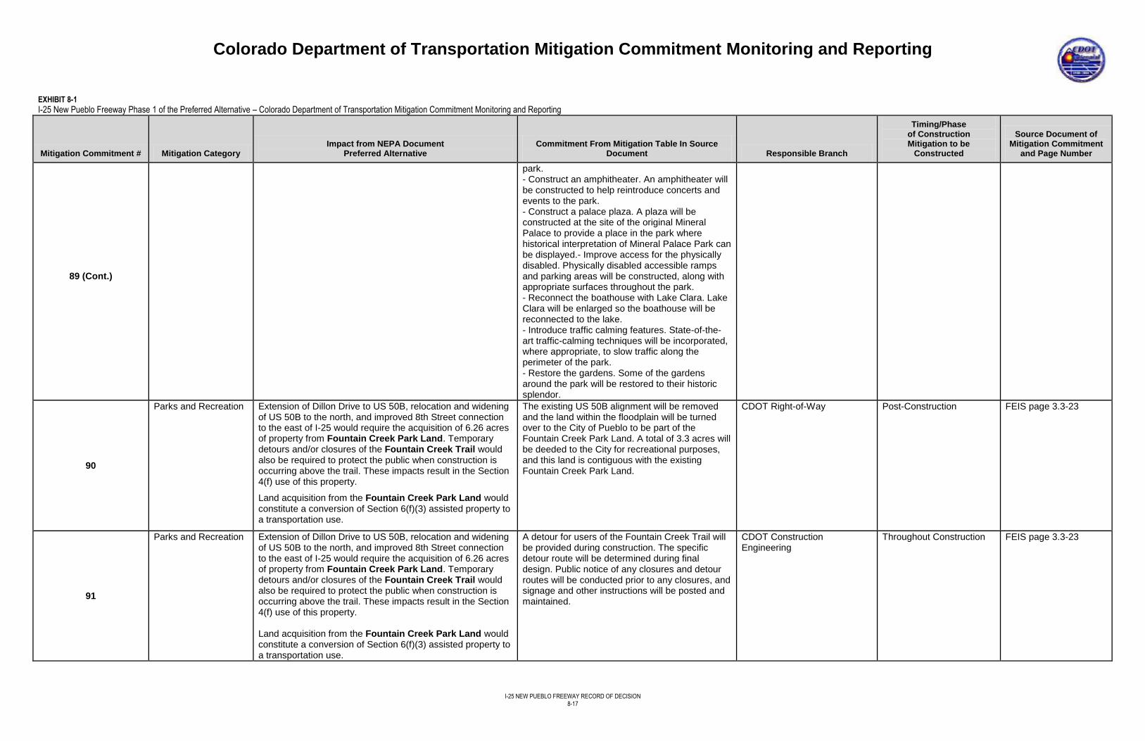
Colorado Department of Transportation Mitigation Commitment Monitoring and Reporting
I-25 NEW PUEBLO FREEWAY RECORD OF DECISION
8-17
EXHIBIT 8-1
I-25 New Pueblo Freeway Phase 1 of the Preferred Alternative – Colorado Department of Transportation Mitigation Commitment Monitoring and Reporting
Mitigation Commitment # Mitigation Category Impact from NEPA Document
Preferred Alternative Commitment From Mitigation Table In Source
Document Responsible Branch
Timing/Phase of Construction Mitigation to be
Constructed
Source Document of Mitigation Commitment
and Page Number
89 (Cont.)
park. - Construct an amphitheater. An amphitheater will be constructed to help reintroduce concerts and events to the park. - Construct a palace plaza. A plaza will be constructed at the site of the original Mineral Palace to provide a place in the park where historical interpretation of Mineral Palace Park can be displayed.- Improve access for the physically disabled. Physically disabled accessible ramps and parking areas will be constructed, along with appropriate surfaces throughout the park. - Reconnect the boathouse with Lake Clara. Lake Clara will be enlarged so the boathouse will be reconnected to the lake. - Introduce traffic calming features. State-of-the-art traffic-calming techniques will be incorporated, where appropriate, to slow traffic along the perimeter of the park. - Restore the gardens. Some of the gardens around the park will be restored to their historic splendor.
90
Parks and Recreation Extension of Dillon Drive to US 50B, relocation and widening of US 50B to the north, and improved 8th Street connection to the east of I-25 would require the acquisition of 6.26 acres of property from Fountain Creek Park Land. Temporary detours and/or closures of the Fountain Creek Trail would also be required to protect the public when construction is occurring above the trail. These impacts result in the Section 4(f) use of this property.
Land acquisition from the Fountain Creek Park Land would constitute a conversion of Section 6(f)(3) assisted property to a transportation use.
The existing US 50B alignment will be removed and the land within the floodplain will be turned over to the City of Pueblo to be part of the Fountain Creek Park Land. A total of 3.3 acres will be deeded to the City for recreational purposes, and this land is contiguous with the existing Fountain Creek Park Land.
CDOT Right-of-Way Post-Construction
FEIS page 3.3-23
91
Parks and Recreation Extension of Dillon Drive to US 50B, relocation and widening of US 50B to the north, and improved 8th Street connection to the east of I-25 would require the acquisition of 6.26 acres of property from Fountain Creek Park Land. Temporary detours and/or closures of the Fountain Creek Trail would also be required to protect the public when construction is occurring above the trail. These impacts result in the Section 4(f) use of this property. Land acquisition from the Fountain Creek Park Land would constitute a conversion of Section 6(f)(3) assisted property to a transportation use.
A detour for users of the Fountain Creek Trail will be provided during construction. The specific detour route will be determined during final design. Public notice of any closures and detour routes will be conducted prior to any closures, and signage and other instructions will be posted and maintained.
CDOT Construction Engineering
Throughout Construction
FEIS page 3.3-23
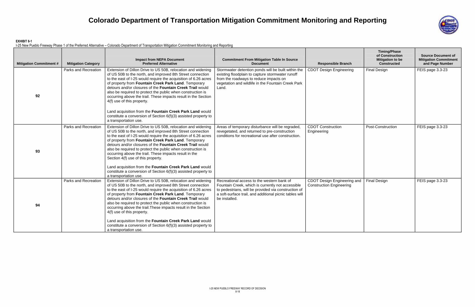
Colorado Department of Transportation Mitigation Commitment Monitoring and Reporting
I-25 NEW PUEBLO FREEWAY RECORD OF DECISION
8-18
EXHIBIT 8-1
I-25 New Pueblo Freeway Phase 1 of the Preferred Alternative – Colorado Department of Transportation Mitigation Commitment Monitoring and Reporting
Mitigation Commitment # Mitigation Category Impact from NEPA Document
Preferred Alternative Commitment From Mitigation Table In Source
Document Responsible Branch
Timing/Phase of Construction Mitigation to be
Constructed
Source Document of Mitigation Commitment
and Page Number
92
Parks and Recreation Extension of Dillon Drive to US 50B, relocation and widening of US 50B to the north, and improved 8th Street connection to the east of I-25 would require the acquisition of 6.26 acres of property from Fountain Creek Park Land. Temporary detours and/or closures of the Fountain Creek Trail would also be required to protect the public when construction is occurring above the trail. These impacts result in the Section 4(f) use of this property.
Land acquisition from the Fountain Creek Park Land would constitute a conversion of Section 6(f)(3) assisted property to a transportation use.
Stormwater detention ponds will be built within the existing floodplain to capture stormwater runoff from the roadways to reduce impacts on vegetation and wildlife in the Fountain Creek Park Land.
CDOT Design Engineering Final Design FEIS page 3.3-23
93
Parks and Recreation Extension of Dillon Drive to US 50B, relocation and widening of US 50B to the north, and improved 8th Street connection to the east of I-25 would require the acquisition of 6.26 acres of property from Fountain Creek Park Land. Temporary detours and/or closures of the Fountain Creek Trail would also be required to protect the public when construction is occurring above the trail. These impacts result in the Section 4(f) use of this property. Land acquisition from the Fountain Creek Park Land would constitute a conversion of Section 6(f)(3) assisted property to a transportation use.
Areas of temporary disturbance will be regraded, revegetated, and returned to pre-construction conditions for recreational use after construction.
CDOT Construction Engineering
Post-Construction
FEIS page 3.3-23
94
Parks and Recreation Extension of Dillon Drive to US 50B, relocation and widening of US 50B to the north, and improved 8th Street connection to the east of I-25 would require the acquisition of 6.26 acres of property from Fountain Creek Park Land. Temporary detours and/or closures of the Fountain Creek Trail would also be required to protect the public when construction is occurring above the trail.These impacts result in the Section 4(f) use of this property. Land acquisition from the Fountain Creek Park Land would constitute a conversion of Section 6(f)(3) assisted property to a transportation use.
Recreational access to the western bank of Fountain Creek, which is currently not accessible to pedestrians, will be provided via construction of a soft-surface trail, and additional picnic tables will be installed.
CDOT Design Engineering and Construction Engineering
Final Design FEIS page 3.3-23
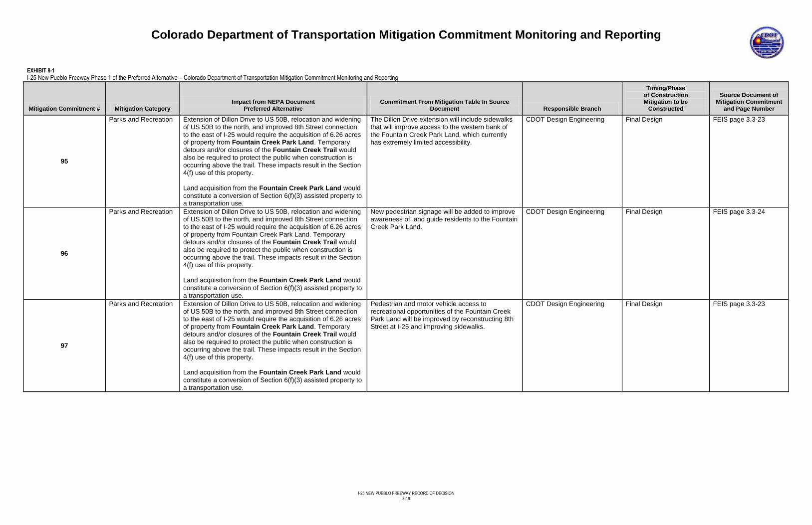
Colorado Department of Transportation Mitigation Commitment Monitoring and Reporting
I-25 NEW PUEBLO FREEWAY RECORD OF DECISION
8-19
EXHIBIT 8-1
I-25 New Pueblo Freeway Phase 1 of the Preferred Alternative – Colorado Department of Transportation Mitigation Commitment Monitoring and Reporting
Mitigation Commitment # Mitigation Category Impact from NEPA Document
Preferred Alternative Commitment From Mitigation Table In Source
Document Responsible Branch
Timing/Phase of Construction Mitigation to be
Constructed
Source Document of Mitigation Commitment
and Page Number
95
Parks and Recreation Extension of Dillon Drive to US 50B, relocation and widening of US 50B to the north, and improved 8th Street connection to the east of I-25 would require the acquisition of 6.26 acres of property from Fountain Creek Park Land. Temporary detours and/or closures of the Fountain Creek Trail would also be required to protect the public when construction is occurring above the trail. These impacts result in the Section 4(f) use of this property. Land acquisition from the Fountain Creek Park Land would constitute a conversion of Section 6(f)(3) assisted property to a transportation use.
The Dillon Drive extension will include sidewalks that will improve access to the western bank of the Fountain Creek Park Land, which currently has extremely limited accessibility.
CDOT Design Engineering Final Design FEIS page 3.3-23
96
Parks and Recreation Extension of Dillon Drive to US 50B, relocation and widening of US 50B to the north, and improved 8th Street connection to the east of I-25 would require the acquisition of 6.26 acres of property from Fountain Creek Park Land. Temporary detours and/or closures of the Fountain Creek Trail would also be required to protect the public when construction is occurring above the trail. These impacts result in the Section 4(f) use of this property. Land acquisition from the Fountain Creek Park Land would constitute a conversion of Section 6(f)(3) assisted property to a transportation use.
New pedestrian signage will be added to improve awareness of, and guide residents to the Fountain Creek Park Land.
CDOT Design Engineering Final Design FEIS page 3.3-24
97
Parks and Recreation Extension of Dillon Drive to US 50B, relocation and widening of US 50B to the north, and improved 8th Street connection to the east of I-25 would require the acquisition of 6.26 acres of property from Fountain Creek Park Land. Temporary detours and/or closures of the Fountain Creek Trail would also be required to protect the public when construction is occurring above the trail. These impacts result in the Section 4(f) use of this property. Land acquisition from the Fountain Creek Park Land would constitute a conversion of Section 6(f)(3) assisted property to a transportation use.
Pedestrian and motor vehicle access to recreational opportunities of the Fountain Creek Park Land will be improved by reconstructing 8th Street at I-25 and improving sidewalks.
CDOT Design Engineering Final Design FEIS page 3.3-23
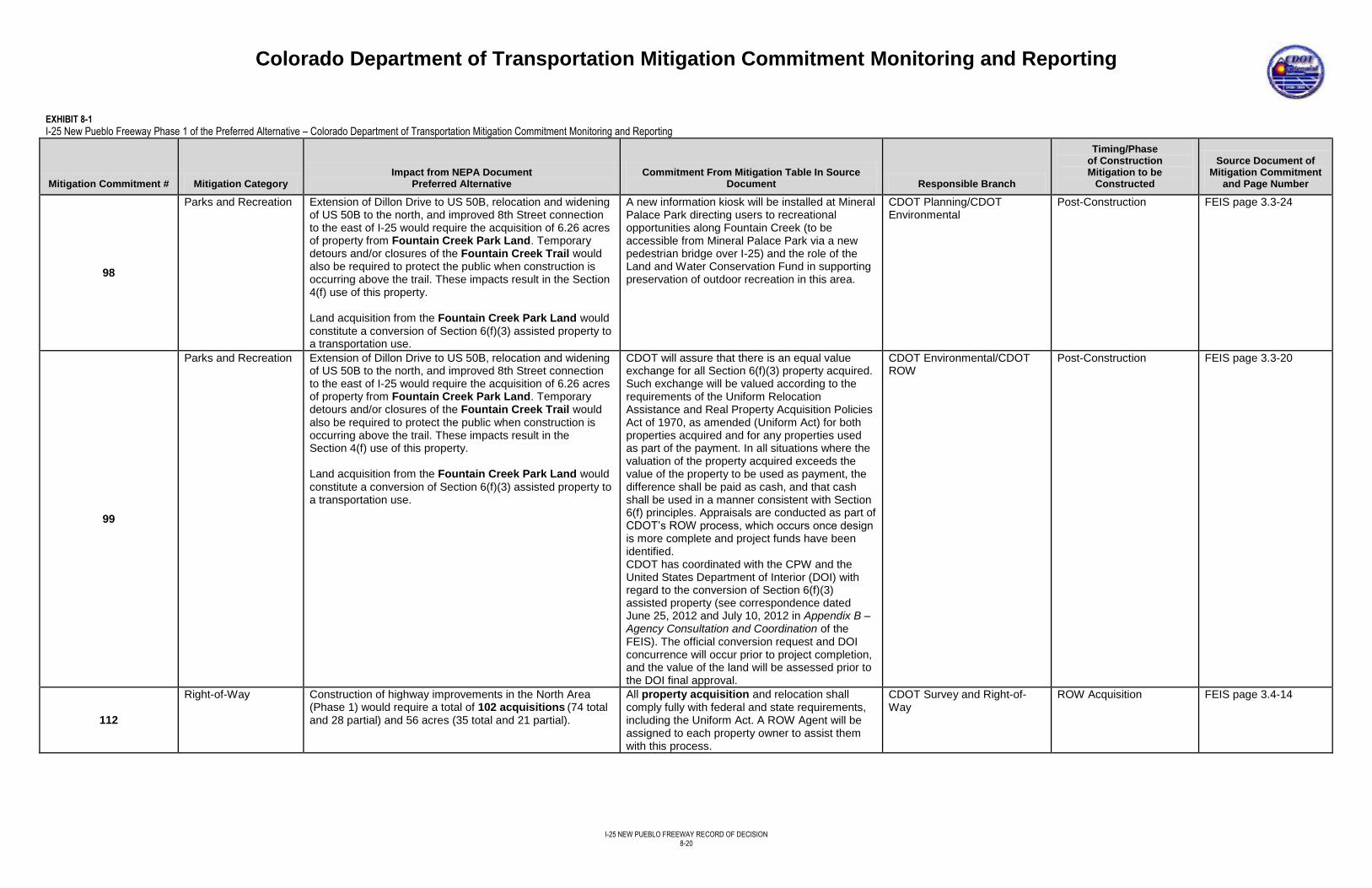
Colorado Department of Transportation Mitigation Commitment Monitoring and Reporting
I-25 NEW PUEBLO FREEWAY RECORD OF DECISION
8-20
EXHIBIT 8-1
I-25 New Pueblo Freeway Phase 1 of the Preferred Alternative – Colorado Department of Transportation Mitigation Commitment Monitoring and Reporting
Mitigation Commitment # Mitigation Category Impact from NEPA Document
Preferred Alternative Commitment From Mitigation Table In Source
Document Responsible Branch
Timing/Phase of Construction Mitigation to be
Constructed
Source Document of Mitigation Commitment
and Page Number
98
Parks and Recreation Extension of Dillon Drive to US 50B, relocation and widening of US 50B to the north, and improved 8th Street connection to the east of I-25 would require the acquisition of 6.26 acres of property from Fountain Creek Park Land. Temporary detours and/or closures of the Fountain Creek Trail would also be required to protect the public when construction is occurring above the trail. These impacts result in the Section 4(f) use of this property. Land acquisition from the Fountain Creek Park Land would constitute a conversion of Section 6(f)(3) assisted property to a transportation use.
A new information kiosk will be installed at Mineral Palace Park directing users to recreational opportunities along Fountain Creek (to be accessible from Mineral Palace Park via a new pedestrian bridge over I-25) and the role of the Land and Water Conservation Fund in supporting preservation of outdoor recreation in this area.
CDOT Planning/CDOT Environmental
Post-Construction FEIS page 3.3-24
99
Parks and Recreation Extension of Dillon Drive to US 50B, relocation and widening of US 50B to the north, and improved 8th Street connection to the east of I-25 would require the acquisition of 6.26 acres of property from Fountain Creek Park Land. Temporary detours and/or closures of the Fountain Creek Trail would also be required to protect the public when construction is occurring above the trail. These impacts result in the Section 4(f) use of this property. Land acquisition from the Fountain Creek Park Land would constitute a conversion of Section 6(f)(3) assisted property to a transportation use.
CDOT will assure that there is an equal value exchange for all Section 6(f)(3) property acquired. Such exchange will be valued according to the requirements of the Uniform Relocation Assistance and Real Property Acquisition Policies Act of 1970, as amended (Uniform Act) for both properties acquired and for any properties used as part of the payment. In all situations where the valuation of the property acquired exceeds the value of the property to be used as payment, the difference shall be paid as cash, and that cash shall be used in a manner consistent with Section 6(f) principles. Appraisals are conducted as part of CDOT’s ROW process, which occurs once design is more complete and project funds have been identified. CDOT has coordinated with the CPW and the United States Department of Interior (DOI) with regard to the conversion of Section 6(f)(3) assisted property (see correspondence dated June 25, 2012 and July 10, 2012 in Appendix B – Agency Consultation and Coordination of the FEIS). The official conversion request and DOI concurrence will occur prior to project completion, and the value of the land will be assessed prior to the DOI final approval.
CDOT Environmental/CDOT ROW
Post-Construction
FEIS page 3.3-20
112
Right-of-Way Construction of highway improvements in the North Area (Phase 1) would require a total of 102 acquisitions (74 total and 28 partial) and 56 acres (35 total and 21 partial).
All property acquisition and relocation shall comply fully with federal and state requirements, including the Uniform Act. A ROW Agent will be assigned to each property owner to assist them with this process.
CDOT Survey and Right-of-Way
ROW Acquisition FEIS page 3.4-14
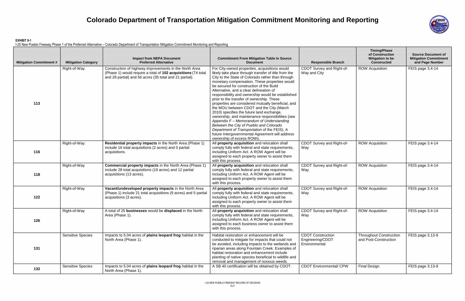
Colorado Department of Transportation Mitigation Commitment Monitoring and Reporting
I-25 NEW PUEBLO FREEWAY RECORD OF DECISION
8-21
EXHIBIT 8-1
I-25 New Pueblo Freeway Phase 1 of the Preferred Alternative – Colorado Department of Transportation Mitigation Commitment Monitoring and Reporting
Mitigation Commitment # Mitigation Category Impact from NEPA Document
Preferred Alternative Commitment From Mitigation Table In Source
Document Responsible Branch
Timing/Phase of Construction Mitigation to be
Constructed
Source Document of Mitigation Commitment
and Page Number
113
Right-of-Way Construction of highway improvements in the North Area (Phase 1) would require a total of 102 acquisitions (74 total and 28 partial) and 56 acres (35 total and 21 partial).
For City-owned properties, acquisitions would likely take place through transfer of title from the City to the State of Colorado rather than through monetary compensation. These properties would be secured for construction of the Build Alternative, and a clear delineation of responsibility and ownership would be established prior to the transfer of ownership. These properties are considered mutually beneficial, and the MOU between CDOT and the City (March 2010) specifies the future land exchange, ownership, and maintenance responsibilities (see Appendix F – Memorandum of Understanding Between the City of Pueblo and Colorado Department of Transportation of the FEIS). A future Intergovernmental Agreement will address ownership of excess ROWs.
CDOT Survey and Right-of-Way and City
ROW Acquisition FEIS page 3.4-14
116
Right-of-Way Residential property impacts in the North Area (Phase 1) include 16 total acquisitions (2 acres) and 0 partial acquisitions.
All property acquisition and relocation shall comply fully with federal and state requirements, including Uniform Act. A ROW Agent will be assigned to each property owner to assist them with this process.
CDOT Survey and Right-of-Way
ROW Acquisition FEIS page 3.4-14
118
Right-of-Way Commercial property impacts in the North Area (Phase 1) include 28 total acquisitions (19 acres) and 12 partial acquisitions (13 acres).
All property acquisition and relocation shall comply fully with federal and state requirements, including Uniform Act. A ROW Agent will be assigned to each property owner to assist them with this process.
CDOT Survey and Right-of-Way
ROW Acquisition FEIS page 3.4-14
122
Right-of-Way Vacant/undeveloped property impacts in the North Area (Phase 1) include 21 total acquisitions (9 acres) and 5 partial acquisitions (3 acres).
All property acquisition and relocation shall comply fully with federal and state requirements, including Uniform Act. A ROW Agent will be assigned to each property owner to assist them with this process.
CDOT Survey and Right-of-Way
ROW Acquisition FEIS page 3.4-14
126
Right-of-Way A total of 25 businesses would be displaced in the North Area (Phase 1).
All property acquisition and relocation shall comply fully with federal and state requirements, including Uniform Act. A ROW Agent will be assigned to each business owner to assist them with this process.
CDOT Survey and Right-of-Way
ROW Acquisition FEIS page 3.4-14
131
Sensitive Species Impacts to 5.04 acres of plains leopard frog habitat in the North Area (Phase 1).
Habitat restoration or enhancement will be conducted to mitigate for impacts that could not be avoided, including impacts to the wetlands and riparian areas along Fountain Creek. Examples of habitat restoration and enhancement include planting of native species beneficial to wildlife and removal and management of noxious weeds.
CDOT Construction Engineering/CDOT Environmental
Throughout Construction and Post-Construction
FEIS page 3.13-9
132 Sensitive Species Impacts to 5.04 acres of plains leopard frog habitat in the
North Area (Phase 1). A SB 40 certification will be obtained by CDOT. CDOT Environmental/ CPW Final Design FEIS page 3.13-9
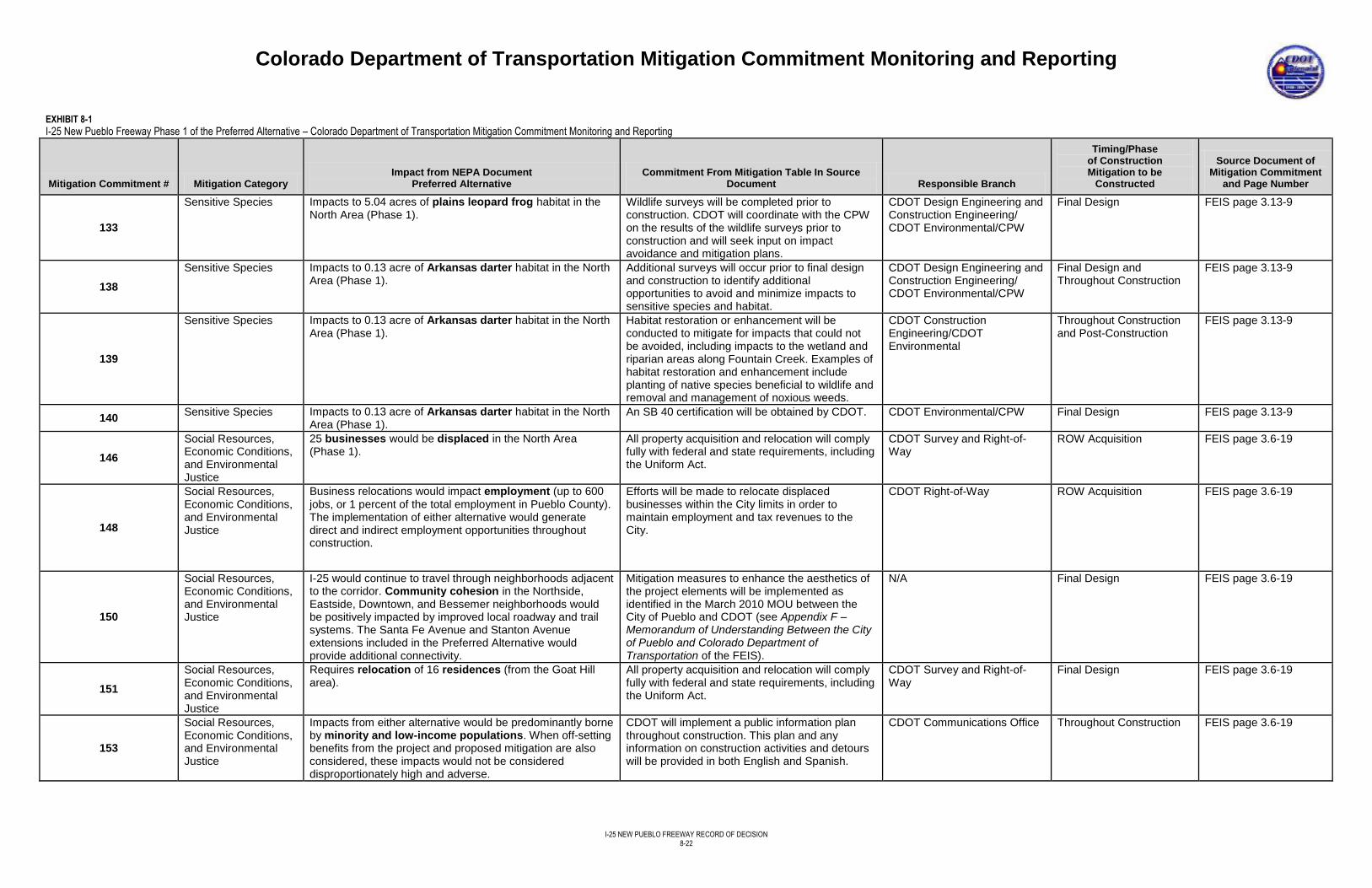
Colorado Department of Transportation Mitigation Commitment Monitoring and Reporting
I-25 NEW PUEBLO FREEWAY RECORD OF DECISION
8-22
EXHIBIT 8-1
I-25 New Pueblo Freeway Phase 1 of the Preferred Alternative – Colorado Department of Transportation Mitigation Commitment Monitoring and Reporting
Mitigation Commitment # Mitigation Category Impact from NEPA Document
Preferred Alternative Commitment From Mitigation Table In Source
Document Responsible Branch
Timing/Phase of Construction Mitigation to be
Constructed
Source Document of Mitigation Commitment
and Page Number
133
Sensitive Species Impacts to 5.04 acres of plains leopard frog habitat in the North Area (Phase 1).
Wildlife surveys will be completed prior to construction. CDOT will coordinate with the CPW on the results of the wildlife surveys prior to construction and will seek input on impact avoidance and mitigation plans.
CDOT Design Engineering and Construction Engineering/ CDOT Environmental/CPW
Final Design FEIS page 3.13-9
138
Sensitive Species Impacts to 0.13 acre of Arkansas darter habitat in the North Area (Phase 1).
Additional surveys will occur prior to final design and construction to identify additional opportunities to avoid and minimize impacts to sensitive species and habitat.
CDOT Design Engineering and Construction Engineering/ CDOT Environmental/CPW
Final Design and Throughout Construction
FEIS page 3.13-9
139
Sensitive Species Impacts to 0.13 acre of Arkansas darter habitat in the North Area (Phase 1).
Habitat restoration or enhancement will be conducted to mitigate for impacts that could not be avoided, including impacts to the wetland and riparian areas along Fountain Creek. Examples of habitat restoration and enhancement include planting of native species beneficial to wildlife and removal and management of noxious weeds.
CDOT Construction Engineering/CDOT Environmental
Throughout Construction and Post-Construction
FEIS page 3.13-9
140 Sensitive Species Impacts to 0.13 acre of Arkansas darter habitat in the North
Area (Phase 1). An SB 40 certification will be obtained by CDOT. CDOT Environmental/CPW Final Design FEIS page 3.13-9
146
Social Resources, Economic Conditions, and Environmental Justice
25 businesses would be displaced in the North Area (Phase 1).
All property acquisition and relocation will comply fully with federal and state requirements, including the Uniform Act.
CDOT Survey and Right-of-Way
ROW Acquisition FEIS page 3.6-19
148
Social Resources, Economic Conditions, and Environmental Justice
Business relocations would impact employment (up to 600 jobs, or 1 percent of the total employment in Pueblo County). The implementation of either alternative would generate direct and indirect employment opportunities throughout construction.
Efforts will be made to relocate displaced businesses within the City limits in order to maintain employment and tax revenues to the City.
CDOT Right-of-Way ROW Acquisition FEIS page 3.6-19
150
Social Resources, Economic Conditions, and Environmental Justice
I-25 would continue to travel through neighborhoods adjacent to the corridor. Community cohesion in the Northside, Eastside, Downtown, and Bessemer neighborhoods would be positively impacted by improved local roadway and trail systems. The Santa Fe Avenue and Stanton Avenue extensions included in the Preferred Alternative would provide additional connectivity.
Mitigation measures to enhance the aesthetics of the project elements will be implemented as identified in the March 2010 MOU between the City of Pueblo and CDOT (see Appendix F – Memorandum of Understanding Between the City of Pueblo and Colorado Department of Transportation of the FEIS).
N/A Final Design
FEIS page 3.6-19
151
Social Resources, Economic Conditions, and Environmental Justice
Requires relocation of 16 residences (from the Goat Hill area).
All property acquisition and relocation will comply fully with federal and state requirements, including the Uniform Act.
CDOT Survey and Right-of-Way
Final Design FEIS page 3.6-19
153
Social Resources, Economic Conditions, and Environmental Justice
Impacts from either alternative would be predominantly borne by minority and low-income populations. When off-setting benefits from the project and proposed mitigation are also considered, these impacts would not be considered disproportionately high and adverse.
CDOT will implement a public information plan throughout construction. This plan and any information on construction activities and detours will be provided in both English and Spanish.
CDOT Communications Office Throughout Construction FEIS page 3.6-19
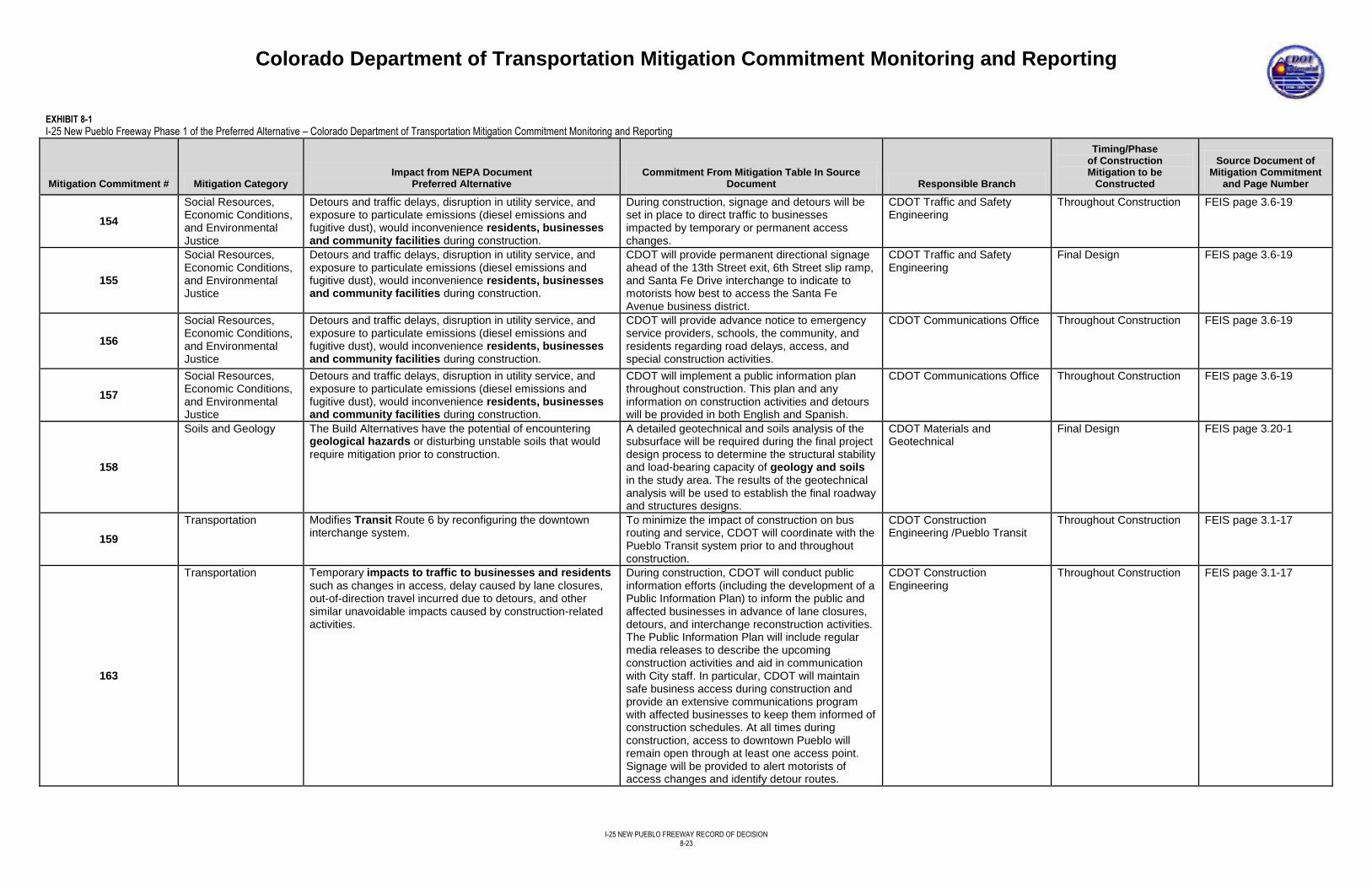
Colorado Department of Transportation Mitigation Commitment Monitoring and Reporting
I-25 NEW PUEBLO FREEWAY RECORD OF DECISION
8-23
EXHIBIT 8-1
I-25 New Pueblo Freeway Phase 1 of the Preferred Alternative – Colorado Department of Transportation Mitigation Commitment Monitoring and Reporting
Mitigation Commitment # Mitigation Category Impact from NEPA Document
Preferred Alternative Commitment From Mitigation Table In Source
Document Responsible Branch
Timing/Phase of Construction Mitigation to be
Constructed
Source Document of Mitigation Commitment
and Page Number
154
Social Resources, Economic Conditions, and Environmental Justice
Detours and traffic delays, disruption in utility service, and exposure to particulate emissions (diesel emissions and fugitive dust), would inconvenience residents, businesses and community facilities during construction.
During construction, signage and detours will be set in place to direct traffic to businesses impacted by temporary or permanent access changes.
CDOT Traffic and Safety Engineering
Throughout Construction FEIS page 3.6-19
155
Social Resources, Economic Conditions, and Environmental Justice
Detours and traffic delays, disruption in utility service, and exposure to particulate emissions (diesel emissions and fugitive dust), would inconvenience residents, businesses and community facilities during construction.
CDOT will provide permanent directional signage ahead of the 13th Street exit, 6th Street slip ramp, and Santa Fe Drive interchange to indicate to motorists how best to access the Santa Fe Avenue business district.
CDOT Traffic and Safety Engineering
Final Design FEIS page 3.6-19
156
Social Resources, Economic Conditions, and Environmental Justice
Detours and traffic delays, disruption in utility service, and exposure to particulate emissions (diesel emissions and fugitive dust), would inconvenience residents, businesses and community facilities during construction.
CDOT will provide advance notice to emergency service providers, schools, the community, and residents regarding road delays, access, and special construction activities.
CDOT Communications Office Throughout Construction FEIS page 3.6-19
157
Social Resources, Economic Conditions, and Environmental Justice
Detours and traffic delays, disruption in utility service, and exposure to particulate emissions (diesel emissions and fugitive dust), would inconvenience residents, businesses and community facilities during construction.
CDOT will implement a public information plan throughout construction. This plan and any information on construction activities and detours will be provided in both English and Spanish.
CDOT Communications Office Throughout Construction FEIS page 3.6-19
158
Soils and Geology The Build Alternatives have the potential of encountering geological hazards or disturbing unstable soils that would require mitigation prior to construction.
A detailed geotechnical and soils analysis of the subsurface will be required during the final project design process to determine the structural stability and load-bearing capacity of geology and soils in the study area. The results of the geotechnical analysis will be used to establish the final roadway and structures designs.
CDOT Materials and Geotechnical
Final Design FEIS page 3.20-1
159
Transportation Modifies Transit Route 6 by reconfiguring the downtown interchange system.
To minimize the impact of construction on bus routing and service, CDOT will coordinate with the Pueblo Transit system prior to and throughout construction.
CDOT Construction Engineering /Pueblo Transit
Throughout Construction
FEIS page 3.1-17
163
Transportation Temporary impacts to traffic to businesses and residents such as changes in access, delay caused by lane closures, out-of-direction travel incurred due to detours, and other similar unavoidable impacts caused by construction-related activities.
During construction, CDOT will conduct public information efforts (including the development of a Public Information Plan) to inform the public and affected businesses in advance of lane closures, detours, and interchange reconstruction activities. The Public Information Plan will include regular media releases to describe the upcoming construction activities and aid in communication with City staff. In particular, CDOT will maintain safe business access during construction and provide an extensive communications program with affected businesses to keep them informed of construction schedules. At all times during construction, access to downtown Pueblo will remain open through at least one access point. Signage will be provided to alert motorists of access changes and identify detour routes.
CDOT Construction Engineering
Throughout Construction FEIS page 3.1-17
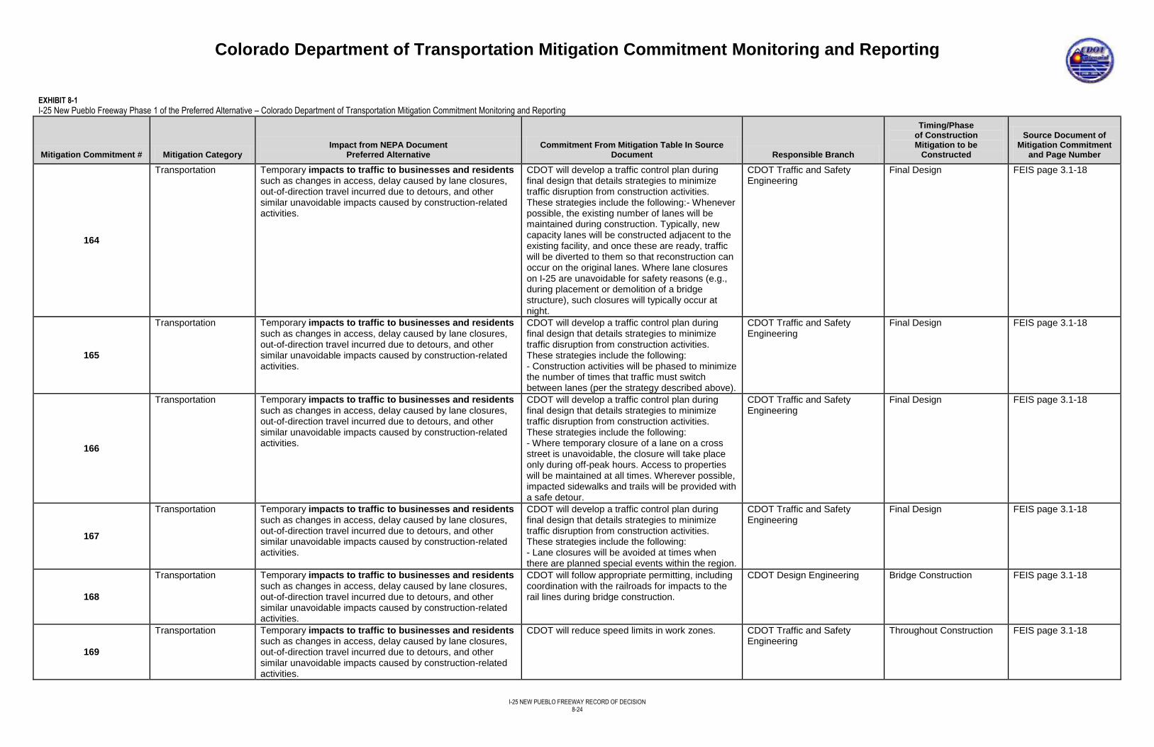
Colorado Department of Transportation Mitigation Commitment Monitoring and Reporting
I-25 NEW PUEBLO FREEWAY RECORD OF DECISION
8-24
EXHIBIT 8-1
I-25 New Pueblo Freeway Phase 1 of the Preferred Alternative – Colorado Department of Transportation Mitigation Commitment Monitoring and Reporting
Mitigation Commitment # Mitigation Category Impact from NEPA Document
Preferred Alternative Commitment From Mitigation Table In Source
Document Responsible Branch
Timing/Phase of Construction Mitigation to be
Constructed
Source Document of Mitigation Commitment
and Page Number
164
Transportation Temporary impacts to traffic to businesses and residents such as changes in access, delay caused by lane closures, out-of-direction travel incurred due to detours, and other similar unavoidable impacts caused by construction-related activities.
CDOT will develop a traffic control plan during final design that details strategies to minimize traffic disruption from construction activities. These strategies include the following:- Whenever possible, the existing number of lanes will be maintained during construction. Typically, new capacity lanes will be constructed adjacent to the existing facility, and once these are ready, traffic will be diverted to them so that reconstruction can occur on the original lanes. Where lane closures on I-25 are unavoidable for safety reasons (e.g., during placement or demolition of a bridge structure), such closures will typically occur at night.
CDOT Traffic and Safety Engineering
Final Design
FEIS page 3.1-18
165
Transportation Temporary impacts to traffic to businesses and residents such as changes in access, delay caused by lane closures, out-of-direction travel incurred due to detours, and other similar unavoidable impacts caused by construction-related activities.
CDOT will develop a traffic control plan during final design that details strategies to minimize traffic disruption from construction activities. These strategies include the following: - Construction activities will be phased to minimize the number of times that traffic must switch between lanes (per the strategy described above).
CDOT Traffic and Safety Engineering
Final Design FEIS page 3.1-18
166
Transportation Temporary impacts to traffic to businesses and residents such as changes in access, delay caused by lane closures, out-of-direction travel incurred due to detours, and other similar unavoidable impacts caused by construction-related activities.
CDOT will develop a traffic control plan during final design that details strategies to minimize traffic disruption from construction activities. These strategies include the following: - Where temporary closure of a lane on a cross street is unavoidable, the closure will take place only during off-peak hours. Access to properties will be maintained at all times. Wherever possible, impacted sidewalks and trails will be provided with a safe detour.
CDOT Traffic and Safety Engineering
Final Design
FEIS page 3.1-18
167
Transportation Temporary impacts to traffic to businesses and residents such as changes in access, delay caused by lane closures, out-of-direction travel incurred due to detours, and other similar unavoidable impacts caused by construction-related activities.
CDOT will develop a traffic control plan during final design that details strategies to minimize traffic disruption from construction activities. These strategies include the following: - Lane closures will be avoided at times when there are planned special events within the region.
CDOT Traffic and Safety Engineering
Final Design FEIS page 3.1-18
168
Transportation Temporary impacts to traffic to businesses and residents such as changes in access, delay caused by lane closures, out-of-direction travel incurred due to detours, and other similar unavoidable impacts caused by construction-related activities.
CDOT will follow appropriate permitting, including coordination with the railroads for impacts to the rail lines during bridge construction.
CDOT Design Engineering Bridge Construction
FEIS page 3.1-18
169
Transportation Temporary impacts to traffic to businesses and residents such as changes in access, delay caused by lane closures, out-of-direction travel incurred due to detours, and other similar unavoidable impacts caused by construction-related activities.
CDOT will reduce speed limits in work zones. CDOT Traffic and Safety Engineering
Throughout Construction
FEIS page 3.1-18
Colorado Department of Transportation Mitigation Commitment Monitoring and Reporting
I-25 NEW PUEBLO FREEWAY RECORD OF DECISION
8-25
EXHIBIT 8-1
I-25 New Pueblo Freeway Phase 1 of the Preferred Alternative – Colorado Department of Transportation Mitigation Commitment Monitoring and Reporting
Mitigation Commitment # Mitigation Category Impact from NEPA Document
Preferred Alternative Commitment From Mitigation Table In Source
Document Responsible Branch
Timing/Phase of Construction Mitigation to be
Constructed
Source Document of Mitigation Commitment
and Page Number
172
Utilities Impacts above- and below-ground utility lines. Approaches and crosses over storm sewers.
During future design efforts, the location of all utilities in the I-25 corridor will be confirmed by field investigations, including locating lines below ground. During design if public or private utilities are located with the project area, the responsible utility company or agency will be contacted to avoid or minimize impacts. If relocation of utilities is required, CDOT will coordinate these efforts with the appropriate utility company or agency. If public or private utilities are expected to be affected by the project, alternate delivery systems will be provided to ensure uninterrupted service, and the lines or stations will be relocated as needed.
CDOT Utilities Final Design FEIS page 3.16-3
177
Visual Resources The increased mass of the highway, noise barriers, and water quality ponds would increase the highway's visual presence in existing neighborhoods along I-25 in the North Area (Phase 1). Alters the Fountain Creek and Downtown viewsheds by introducing new roadway modifications. Within the Downtown Viewshed, the highway would continue to be elevated on a series of embankments, bridges, and viaducts between 6th Street and the Arkansas River. In several locations, I-25 would be 35 feet above its existing elevation between 13th Street and 6th Street, making the highway more visually apparent than it is today.
The New Pueblo Freeway Aesthetic Guidelines (see Appendix C – Aesthetic Guidelines of the FEIS) will be used during final design and construction to help CDOT identify appropriate aesthetic design elements to ensure compatibility within the community and each viewshed.
CDOT Design Engineering Final Design
FEIS page 3.9-10
179
Visual Resources The increased mass of the highway, noise barriers, and water quality ponds would increase the highway's visual presence in existing neighborhoods along I-25 in the North Area (Phase 1). Alters the Fountain Creek and Downtown viewsheds by introducing new roadway modifications. Within the Downtown Viewshed, the highway would continue to be elevated on a series of embankments, bridges, and viaducts between 6th Street and the Arkansas River. In several locations, I-25 would be 35 feet above its existing elevation between 13th Street and 6th Street, making the highway more visually apparent than it is today.
Measures to soften and enhance the aesthetics of the highway improvements will be implemented as identified in the March 2010 MOU between the City and CDOT (see Appendix F – Memorandum of Understanding Between the City of Pueblo and Colorado Department of Transportation of the FEIS). The following measures are included: - Gateway features for the City boundaries, downtown, and neighborhoods.
CDOT Design Engineering Final Design FEIS page 3.9-10
Colorado Department of Transportation Mitigation Commitment Monitoring and Reporting
I-25 NEW PUEBLO FREEWAY RECORD OF DECISION
8-26
EXHIBIT 8-1
I-25 New Pueblo Freeway Phase 1 of the Preferred Alternative – Colorado Department of Transportation Mitigation Commitment Monitoring and Reporting
Mitigation Commitment # Mitigation Category Impact from NEPA Document
Preferred Alternative Commitment From Mitigation Table In Source
Document Responsible Branch
Timing/Phase of Construction Mitigation to be
Constructed
Source Document of Mitigation Commitment
and Page Number
181
Visual Resources The increased mass of the highway, noise barriers, and water quality ponds would increase the highway's visual presence in existing neighborhoods along I-25 in the North Area (Phase 1). Alters the Fountain Creek and Downtown viewsheds by introducing new roadway modifications. Within the Downtown Viewshed, the highway would continue to be elevated on a series of embankments, bridges, and viaducts between 6th Street and the Arkansas River. In several locations, I-25 would be 35 feet above its existing elevation between 13th Street and 6th Street, making the highway more visually apparent than it is today.
Architectural treatments on retaining walls, bridges, and other structures designed to reflect the architectural character of the surrounding area.
CDOT Design Engineering Final Design FEIS page 3.9-10
183
Visual Resources The increased mass of the highway, noise barriers, and water quality ponds would increase the highway's visual presence in existing neighborhoods along I-25 in the North Area (Phase 1). Alters the Fountain Creek and Downtown viewsheds by introducing new roadway modifications. Within the Downtown Viewshed, the highway would continue to be elevated on a series of embankments, bridges, and viaducts between 6th Street and the Arkansas River. In several locations, I-25 would be 35 feet above its existing elevation between 13th Street and 6th Street, making the highway more visually apparent than it is today.
Landscaping of roadway shoulders with dryland grasses and creation of naturalized areas that take advantage of local runoff to allow native vegetation, including trees and shrubs, to become established.
CDOT Design Engineering Final Design FEIS pages 3.9-10 and 3.9-11
185
Water Quality Increases in impervious surface and additional traffic on I-25 will generate more pollutants regardless of alternative. BMPs in compliance with the Colorado Discharge Permit System (CDPS) Municipal Separate Storm Sewer System MS4 permit requirements are designed to decrease the amount of pollutants actually entering the waters and are expected to lower the amounts of pollutants when compared to the No Action Alternative.
The percent of pollutant removal from captured roadway runoff will be calculated during final design when structural BMPs are determined. BMPs will be selected such that there is no increase in pollutant loading studied as a result of the New Pueblo Freeway project.
CDOT Construction Engineering
Final Design FEIS page 3.15-7
186
Water Quality Increases in impervious surface and additional traffic on I-25 will generate more pollutants regardless of alternative. BMPs in compliance with the CDPS MS4 permit requirements are designed to decrease the amount of pollutants actually entering the waters and are expected to lower the amounts of pollutants when compared to the No Action Alternative.
Pond volumes will be based on detaining for release at pre-development rates and treating only the flows originating within the project area (onsite basins and side streets), while allowing the offsite basins to pass through undetained. Stormwater runoff from offsite basins will be conveyed through the proposed drainage system without flow attenuation or stormwater quality treatment. Allowable release rates also will affect pond volumes.
CDOT Design Engineering Final Design
FEIS page 3.15-7
Colorado Department of Transportation Mitigation Commitment Monitoring and Reporting
I-25 NEW PUEBLO FREEWAY RECORD OF DECISION
8-27
EXHIBIT 8-1
I-25 New Pueblo Freeway Phase 1 of the Preferred Alternative – Colorado Department of Transportation Mitigation Commitment Monitoring and Reporting
Mitigation Commitment # Mitigation Category Impact from NEPA Document
Preferred Alternative Commitment From Mitigation Table In Source
Document Responsible Branch
Timing/Phase of Construction Mitigation to be
Constructed
Source Document of Mitigation Commitment
and Page Number
187
Water Quality Increases in impervious surface and additional traffic on I-25 will generate more pollutants regardless of alternative. BMPs in compliance with the CDPS MS4 permit requirements are designed to decrease the amount of pollutants actually entering the waters and are expected to lower the amounts of pollutants when compared to the No Action Alternative.
CDOT will develop Tier 1 BMPs because the project is considered a significant highway modification and the receiving waters are classified as sensitive waters (listed on 303(d) high quality use classification or existence of threatened or endangered species). Tier 1 BMPs require that the volume collected is based on the area of disturbance of the project in accordance with the New Development and Redevelopment Manual.
CDOT Construction Engineering
Throughout Construction FEIS page 3.15-7
188
Water Quality Increases in impervious surface and additional traffic on I-25 will generate more pollutants regardless of alternative. BMPs in compliance with the CDPS MS4 permit requirements are designed to decrease the amount of pollutants actually entering the waters and are expected to lower the amounts of pollutants when compared to the No Action Alternative.
CDOT will design and construct permanent BMPs (such as extended detention ponds, infiltration trenches, or constructed sand filters) within the guidelines set by the CDOT New Development and Redevelopment Program. All highway runoff will be collected and treated to the level required by the New Development and Redevelopment Program. An adequate storm drainage system for the existing and proposed improvements near the interchange will be developed to prevent high levels of sediment and pollutants from being carried into wetlands, natural drainage ways, and irrigation ditches. BMPs with pollutant removal for lead, zinc, copper, and selenium shall be incorporated where applicable. These BMPs could prevent impacts to aquatic life through bioaccumulation of metals. Suitable permanent BMPs include detention ponds with sedimentation facilities, enlarged detention basins, constructed sand filters, grass swales and buffers, and innovative vault-type structures where space is limited. These permanent BMPs can be constructed, where appropriate, to intercept, divert, and collect surface runoff and convey accumulated runoff to an acceptable outlet point (see Chapter 6 in the CDOT Erosion Control and Stormwater Quality Guide [CDOT, 2002]).
CDOT Construction Engineering
Throughout Construction FEIS page 3.15-7
Colorado Department of Transportation Mitigation Commitment Monitoring and Reporting
I-25 NEW PUEBLO FREEWAY RECORD OF DECISION
8-28
EXHIBIT 8-1
I-25 New Pueblo Freeway Phase 1 of the Preferred Alternative – Colorado Department of Transportation Mitigation Commitment Monitoring and Reporting
Mitigation Commitment # Mitigation Category Impact from NEPA Document
Preferred Alternative Commitment From Mitigation Table In Source
Document Responsible Branch
Timing/Phase of Construction Mitigation to be
Constructed
Source Document of Mitigation Commitment
and Page Number
189
Water Quality Increases in impervious surface and additional traffic on I-25 will generate more pollutants regardless of alternative. BMPs in compliance with the CDPS MS4 permit requirements are designed to decrease the amount of pollutants actually entering the waters and are expected to lower the amounts of pollutants when compared to the No Action Alternative.
CDOT will use an interconnected system of onsite dry detention facilities and offsite basins for reducing peak runoff flow rates and will utilize a conveyance network for routing flows along their existing flow paths either to the Arkansas River or Fountain Creek. Because Tier 1 BMPs are required, extended detention basins were selected because they can be used in conjunction with a peak flow control drainage system. The exact number of ponds may be modified based on design.
CDOT Design Engineering Final Design
FEIS page 3.15-7
190
Water Quality Increases in impervious surface and additional traffic on I-25 will generate more pollutants regardless of alternative. BMPs in compliance with the CDPS MS4 permit requirements are designed to decrease the amount of pollutants actually entering the waters and are expected to lower the amounts of pollutants when compared to the No Action Alternative.
Non-structural BMPs (such as pesticide and fertilizer application guidelines) and anti-icing and deicing guidelines will be employed to improve water quality in conjunction with BMP implementation. Other non-structural BMPs (such as water quality signage adjacent to the receiving streams and irrigation ditches) will be considered for implementation.
CDOT Construction Engineering
Throughout Construction
FEIS page 3.15-7
191
Water Quality Increases in impervious surface and additional traffic on I-25 will generate more pollutants regardless of alternative. BMPs in compliance with the CDPS MS4 permit requirements are designed to decrease the amount of pollutants actually entering the waters and are expected to lower the amounts of pollutants when compared to the No Action Alternative.
CDOT will adhere to National Pollutant Discharge Elimination System regulations for stormwater quality, including obtaining a CDPS stormwater construction discharge permit and Section 402 dewatering permit, during construction.
CDOT Permitting Throughout Construction
FEIS page 3.15-8
192
Water Quality Increases in impervious surface and additional traffic on I-25 will generate more pollutants regardless of alternative. BMPs in compliance with the CDPS MS4 permit requirements are designed to decrease the amount of pollutants actually entering the waters and are expected to lower the amounts of pollutants when compared to the No Action Alternative.
All work performed on the project will be performed in accordance with appropriate CDOT Standard Specifications for Roadway and Bridge Construction (101.95;107.25; 208; 212; 213; 216; 620) (CDOT, 2011b) and the M&S Standard Plans (CDOT, 2012).
CDOT Construction Engineering
Throughout Construction
FEIS page 3.15-8
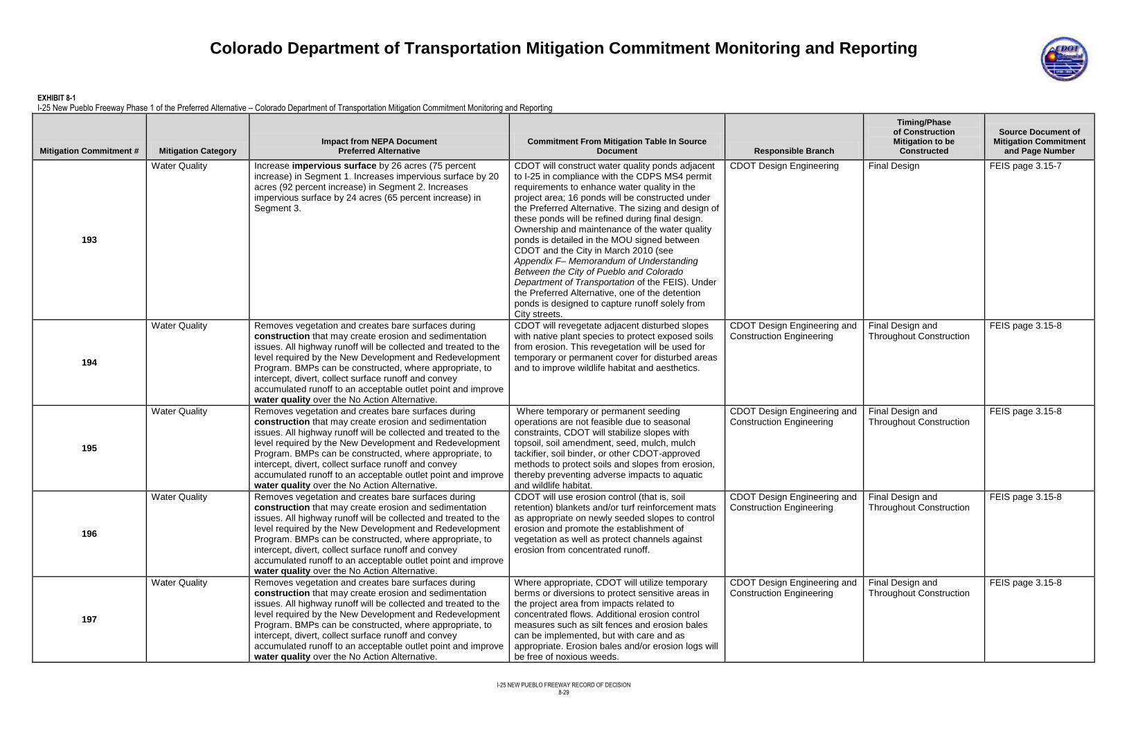
Colorado Department of Transportation Mitigation Commitment Monitoring and Reporting
I-25 NEW PUEBLO FREEWAY RECORD OF DECISION
8-29
EXHIBIT 8-1
I-25 New Pueblo Freeway Phase 1 of the Preferred Alternative – Colorado Department of Transportation Mitigation Commitment Monitoring and Reporting
Mitigation Commitment # Mitigation Category Impact from NEPA Document
Preferred Alternative Commitment From Mitigation Table In Source
Document Responsible Branch
Timing/Phase of Construction Mitigation to be
Constructed
Source Document of Mitigation Commitment
and Page Number
193
Water Quality Increase impervious surface by 26 acres (75 percent increase) in Segment 1. Increases impervious surface by 20 acres (92 percent increase) in Segment 2. Increases impervious surface by 24 acres (65 percent increase) in Segment 3.
CDOT will construct water quality ponds adjacent to I-25 in compliance with the CDPS MS4 permit requirements to enhance water quality in the project area; 16 ponds will be constructed under the Preferred Alternative. The sizing and design of these ponds will be refined during final design. Ownership and maintenance of the water quality ponds is detailed in the MOU signed between CDOT and the City in March 2010 (see Appendix F– Memorandum of Understanding Between the City of Pueblo and Colorado Department of Transportation of the FEIS). Under the Preferred Alternative, one of the detention ponds is designed to capture runoff solely from City streets.
CDOT Design Engineering Final Design FEIS page 3.15-7
194
Water Quality Removes vegetation and creates bare surfaces during construction that may create erosion and sedimentation issues. All highway runoff will be collected and treated to the level required by the New Development and Redevelopment Program. BMPs can be constructed, where appropriate, to intercept, divert, collect surface runoff and convey accumulated runoff to an acceptable outlet point and improve water quality over the No Action Alternative.
CDOT will revegetate adjacent disturbed slopes with native plant species to protect exposed soils from erosion. This revegetation will be used for temporary or permanent cover for disturbed areas and to improve wildlife habitat and aesthetics.
CDOT Design Engineering and Construction Engineering
Final Design and Throughout Construction
FEIS page 3.15-8
195
Water Quality Removes vegetation and creates bare surfaces during construction that may create erosion and sedimentation issues. All highway runoff will be collected and treated to the level required by the New Development and Redevelopment Program. BMPs can be constructed, where appropriate, to intercept, divert, collect surface runoff and convey accumulated runoff to an acceptable outlet point and improve water quality over the No Action Alternative.
Where temporary or permanent seeding operations are not feasible due to seasonal constraints, CDOT will stabilize slopes with topsoil, soil amendment, seed, mulch, mulch tackifier, soil binder, or other CDOT-approved methods to protect soils and slopes from erosion, thereby preventing adverse impacts to aquatic and wildlife habitat.
CDOT Design Engineering and Construction Engineering
Final Design and Throughout Construction
FEIS page 3.15-8
196
Water Quality Removes vegetation and creates bare surfaces during construction that may create erosion and sedimentation issues. All highway runoff will be collected and treated to the level required by the New Development and Redevelopment Program. BMPs can be constructed, where appropriate, to intercept, divert, collect surface runoff and convey accumulated runoff to an acceptable outlet point and improve water quality over the No Action Alternative.
CDOT will use erosion control (that is, soil retention) blankets and/or turf reinforcement mats as appropriate on newly seeded slopes to control erosion and promote the establishment of vegetation as well as protect channels against erosion from concentrated runoff.
CDOT Design Engineering and Construction Engineering
Final Design and Throughout Construction
FEIS page 3.15-8
197
Water Quality Removes vegetation and creates bare surfaces during construction that may create erosion and sedimentation issues. All highway runoff will be collected and treated to the level required by the New Development and Redevelopment Program. BMPs can be constructed, where appropriate, to intercept, divert, collect surface runoff and convey accumulated runoff to an acceptable outlet point and improve water quality over the No Action Alternative.
Where appropriate, CDOT will utilize temporary berms or diversions to protect sensitive areas in the project area from impacts related to concentrated flows. Additional erosion control measures such as silt fences and erosion bales can be implemented, but with care and as appropriate. Erosion bales and/or erosion logs will be free of noxious weeds.
CDOT Design Engineering and Construction Engineering
Final Design and Throughout Construction
FEIS page 3.15-8
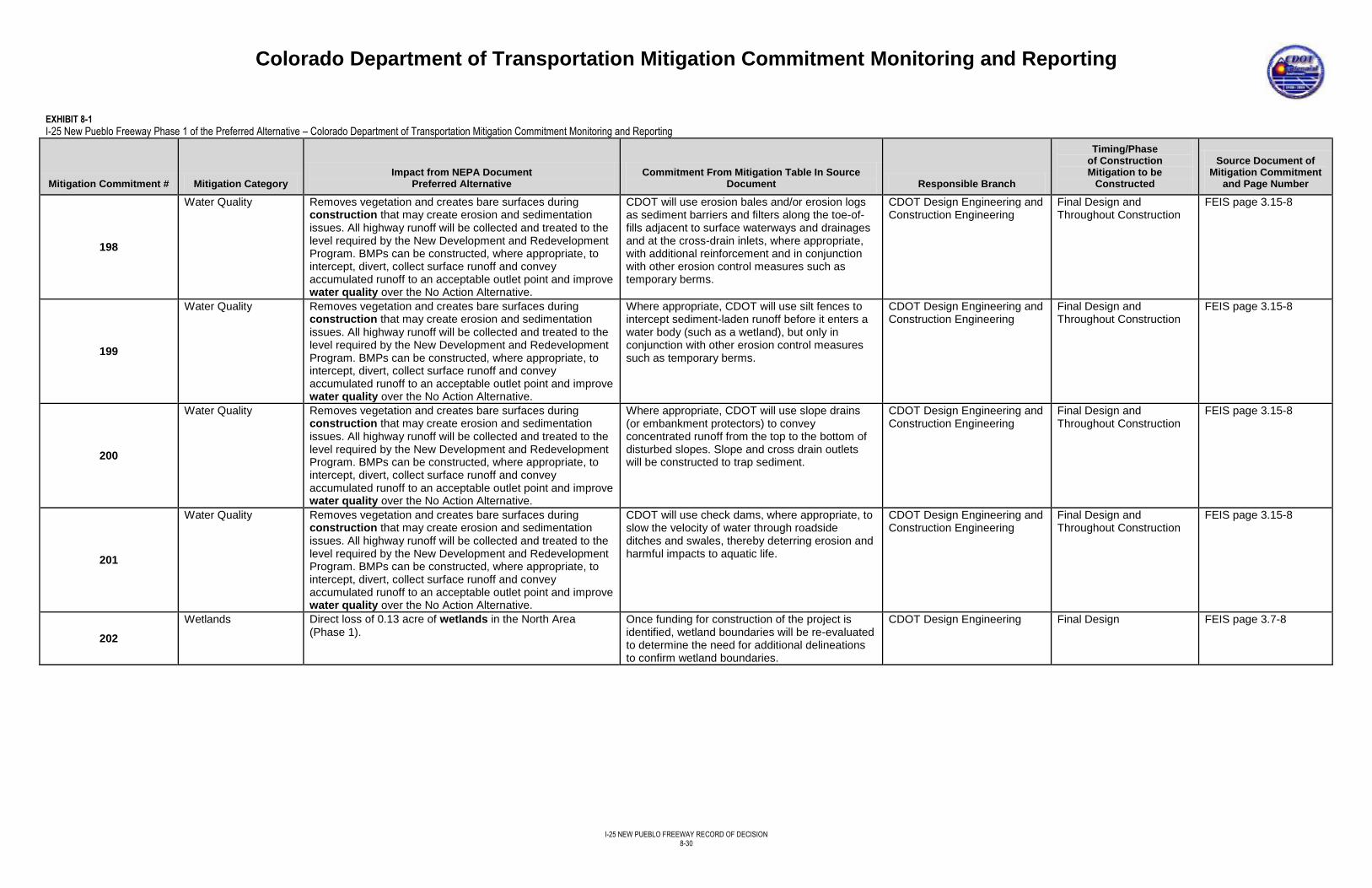
Colorado Department of Transportation Mitigation Commitment Monitoring and Reporting
I-25 NEW PUEBLO FREEWAY RECORD OF DECISION
8-30
EXHIBIT 8-1
I-25 New Pueblo Freeway Phase 1 of the Preferred Alternative – Colorado Department of Transportation Mitigation Commitment Monitoring and Reporting
Mitigation Commitment # Mitigation Category Impact from NEPA Document
Preferred Alternative Commitment From Mitigation Table In Source
Document Responsible Branch
Timing/Phase of Construction Mitigation to be
Constructed
Source Document of Mitigation Commitment
and Page Number
198
Water Quality Removes vegetation and creates bare surfaces during construction that may create erosion and sedimentation issues. All highway runoff will be collected and treated to the level required by the New Development and Redevelopment Program. BMPs can be constructed, where appropriate, to intercept, divert, collect surface runoff and convey accumulated runoff to an acceptable outlet point and improve water quality over the No Action Alternative.
CDOT will use erosion bales and/or erosion logs as sediment barriers and filters along the toe-of-fills adjacent to surface waterways and drainages and at the cross-drain inlets, where appropriate, with additional reinforcement and in conjunction with other erosion control measures such as temporary berms.
CDOT Design Engineering and Construction Engineering
Final Design and Throughout Construction
FEIS page 3.15-8
199
Water Quality Removes vegetation and creates bare surfaces during construction that may create erosion and sedimentation issues. All highway runoff will be collected and treated to the level required by the New Development and Redevelopment Program. BMPs can be constructed, where appropriate, to intercept, divert, collect surface runoff and convey accumulated runoff to an acceptable outlet point and improve water quality over the No Action Alternative.
Where appropriate, CDOT will use silt fences to intercept sediment-laden runoff before it enters a water body (such as a wetland), but only in conjunction with other erosion control measures such as temporary berms.
CDOT Design Engineering and Construction Engineering
Final Design and Throughout Construction
FEIS page 3.15-8
200
Water Quality Removes vegetation and creates bare surfaces during construction that may create erosion and sedimentation issues. All highway runoff will be collected and treated to the level required by the New Development and Redevelopment Program. BMPs can be constructed, where appropriate, to intercept, divert, collect surface runoff and convey accumulated runoff to an acceptable outlet point and improve water quality over the No Action Alternative.
Where appropriate, CDOT will use slope drains (or embankment protectors) to convey concentrated runoff from the top to the bottom of disturbed slopes. Slope and cross drain outlets will be constructed to trap sediment.
CDOT Design Engineering and Construction Engineering
Final Design and Throughout Construction
FEIS page 3.15-8
201
Water Quality Removes vegetation and creates bare surfaces during construction that may create erosion and sedimentation issues. All highway runoff will be collected and treated to the level required by the New Development and Redevelopment Program. BMPs can be constructed, where appropriate, to intercept, divert, collect surface runoff and convey accumulated runoff to an acceptable outlet point and improve water quality over the No Action Alternative.
CDOT will use check dams, where appropriate, to slow the velocity of water through roadside ditches and swales, thereby deterring erosion and harmful impacts to aquatic life.
CDOT Design Engineering and Construction Engineering
Final Design and Throughout Construction
FEIS page 3.15-8
202
Wetlands Direct loss of 0.13 acre of wetlands in the North Area (Phase 1).
Once funding for construction of the project is identified, wetland boundaries will be re-evaluated to determine the need for additional delineations to confirm wetland boundaries.
CDOT Design Engineering Final Design FEIS page 3.7-8
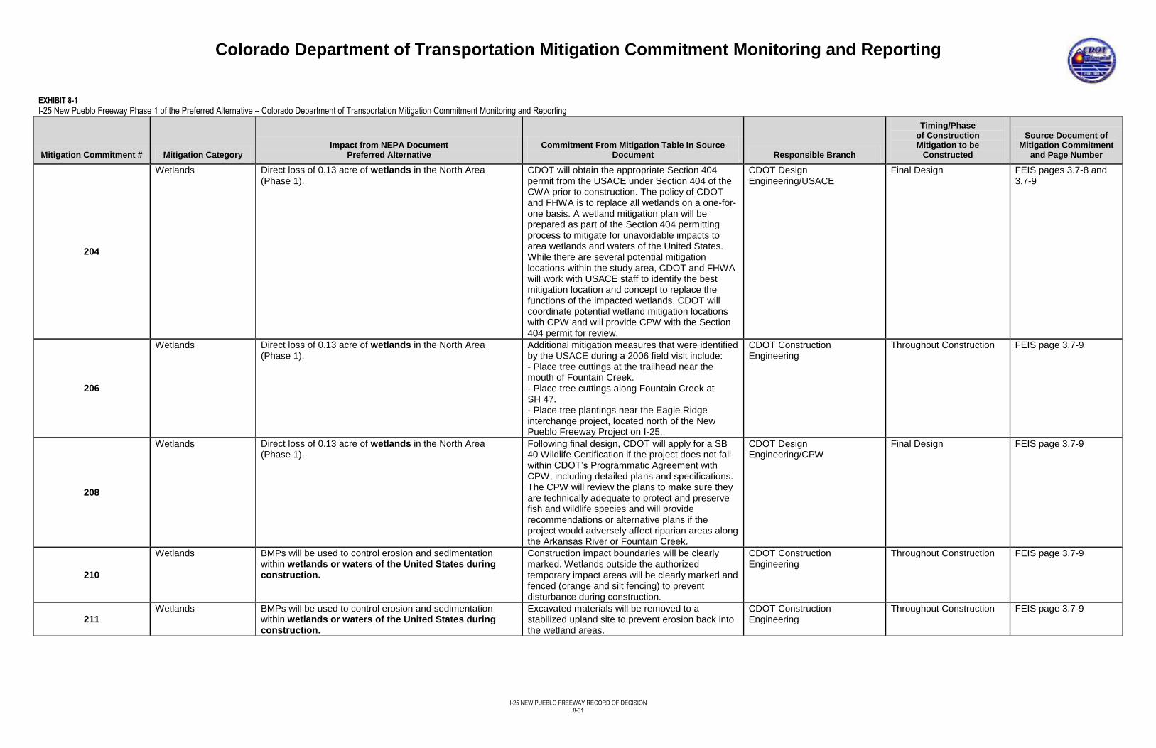
Colorado Department of Transportation Mitigation Commitment Monitoring and Reporting
I-25 NEW PUEBLO FREEWAY RECORD OF DECISION
8-31
EXHIBIT 8-1
I-25 New Pueblo Freeway Phase 1 of the Preferred Alternative – Colorado Department of Transportation Mitigation Commitment Monitoring and Reporting
Mitigation Commitment # Mitigation Category Impact from NEPA Document
Preferred Alternative Commitment From Mitigation Table In Source
Document Responsible Branch
Timing/Phase of Construction Mitigation to be
Constructed
Source Document of Mitigation Commitment
and Page Number
204
Wetlands Direct loss of 0.13 acre of wetlands in the North Area (Phase 1).
CDOT will obtain the appropriate Section 404 permit from the USACE under Section 404 of the CWA prior to construction. The policy of CDOT and FHWA is to replace all wetlands on a one-for-one basis. A wetland mitigation plan will be prepared as part of the Section 404 permitting process to mitigate for unavoidable impacts to area wetlands and waters of the United States. While there are several potential mitigation locations within the study area, CDOT and FHWA will work with USACE staff to identify the best mitigation location and concept to replace the functions of the impacted wetlands. CDOT will coordinate potential wetland mitigation locations with CPW and will provide CPW with the Section 404 permit for review.
CDOT Design Engineering/USACE
Final Design FEIS pages 3.7-8 and 3.7-9
206
Wetlands Direct loss of 0.13 acre of wetlands in the North Area (Phase 1).
Additional mitigation measures that were identified by the USACE during a 2006 field visit include: - Place tree cuttings at the trailhead near the mouth of Fountain Creek. - Place tree cuttings along Fountain Creek at SH 47. - Place tree plantings near the Eagle Ridge interchange project, located north of the New Pueblo Freeway Project on I-25.
CDOT Construction Engineering
Throughout Construction
FEIS page 3.7-9
208
Wetlands Direct loss of 0.13 acre of wetlands in the North Area (Phase 1).
Following final design, CDOT will apply for a SB 40 Wildlife Certification if the project does not fall within CDOT’s Programmatic Agreement with CPW, including detailed plans and specifications. The CPW will review the plans to make sure they are technically adequate to protect and preserve fish and wildlife species and will provide recommendations or alternative plans if the project would adversely affect riparian areas along the Arkansas River or Fountain Creek.
CDOT Design Engineering/CPW
Final Design FEIS page 3.7-9
210
Wetlands BMPs will be used to control erosion and sedimentation within wetlands or waters of the United States during construction.
Construction impact boundaries will be clearly marked. Wetlands outside the authorized temporary impact areas will be clearly marked and fenced (orange and silt fencing) to prevent disturbance during construction.
CDOT Construction Engineering
Throughout Construction FEIS page 3.7-9
211 Wetlands BMPs will be used to control erosion and sedimentation
within wetlands or waters of the United States during construction.
Excavated materials will be removed to a stabilized upland site to prevent erosion back into the wetland areas.
CDOT Construction Engineering
Throughout Construction FEIS page 3.7-9
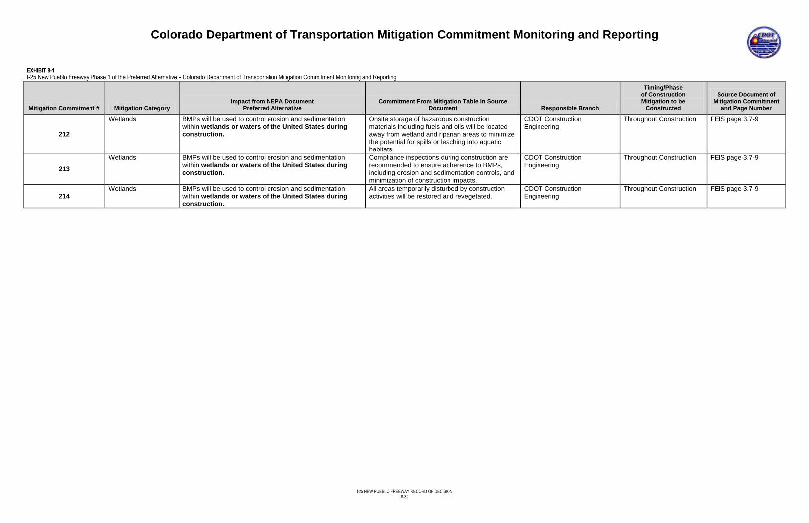
Colorado Department of Transportation Mitigation Commitment Monitoring and Reporting
I-25 NEW PUEBLO FREEWAY RECORD OF DECISION
8-32
EXHIBIT 8-1
I-25 New Pueblo Freeway Phase 1 of the Preferred Alternative – Colorado Department of Transportation Mitigation Commitment Monitoring and Reporting
Mitigation Commitment # Mitigation Category Impact from NEPA Document
Preferred Alternative Commitment From Mitigation Table In Source
Document Responsible Branch
Timing/Phase of Construction Mitigation to be
Constructed
Source Document of Mitigation Commitment
and Page Number
212
Wetlands BMPs will be used to control erosion and sedimentation within wetlands or waters of the United States during construction.
Onsite storage of hazardous construction materials including fuels and oils will be located away from wetland and riparian areas to minimize the potential for spills or leaching into aquatic habitats.
CDOT Construction Engineering
Throughout Construction FEIS page 3.7-9
213
Wetlands BMPs will be used to control erosion and sedimentation within wetlands or waters of the United States during construction.
Compliance inspections during construction are recommended to ensure adherence to BMPs, including erosion and sedimentation controls, and minimization of construction impacts.
CDOT Construction Engineering
Throughout Construction FEIS page 3.7-9
214 Wetlands BMPs will be used to control erosion and sedimentation
within wetlands or waters of the United States during construction.
All areas temporarily disturbed by construction activities will be restored and revegetated.
CDOT Construction Engineering
Throughout Construction FEIS page 3.7-9
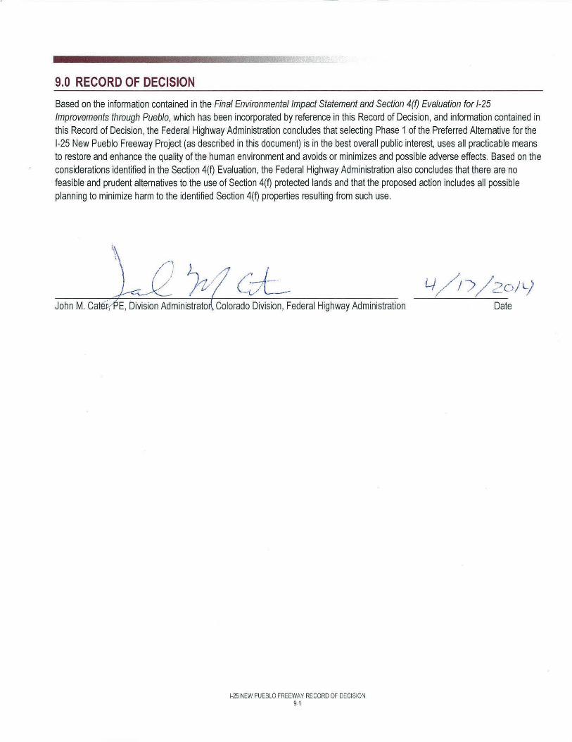
9.0 RECORD OF DECISION
Based on the information contained in the Final Environmental Impact Statement and Section 4m Evaluation for 1-25 Improvements through Pueblo, which has been incorporated by reference in this Record of Decision, and information contained in this Record of Decision, the Federal Highway Administration concludes that selecting Phase 1 of the Preferred Alternative for the 1-25 New Pueblo Freeway Project (as described in this document) is in the best overall public interest, uses all practicable means to restore and enhance the quality of the human environment and avoids or minimizes and possible adverse effects. Based on the considerations identified in the Section 4(D Evaluation, the Federal Highway Administration also concludes that there are no feasible and prudent alternatives to the use of Section 4(D protected lands and that the proposed action includes all possible planning to minimize harm to the identified Section 4(D properties resulting from such use.
\ I
John M. Cat(v,PE, Division Administrate Colorado Division, Federal Highway Administration
1-25 NEW PUEBLO FREEWAY RECORD OF DECISION 9-1
Lj/ ,/; ') /2oJ L) Date
I-25 NEW PUEBLO FREEWAY RECORD OF DECISION
10-1
10.0 REFERENCES
CDOT. 2002. Erosion Control and Stormwater Quality Guide.
CDOT. 2011a. CDOT Noise Analysis and Abatement Guidelines. March 23.
CDOT. 2011b. Standard Specifications for Roadway and Bridge Construction.
CDOT. 2011c. 2035 Statewide Transportation Plan Amendment. http://www.coloradodot.info/programs/statewide-planning/long-range-transportation-plans.html. May.
CDOT. 2012. M&S Standards Plans. http://www.coloradodot.info/business/designsupport/standard-plans. Revised October 18.
CDOT and FHWA. 2011. Draft Environmental Impact Statement and Section and Section 4(f) Evaluation for I-25 Improvements Through Pueblo. November.
CDOT and FHWA, 2013. Final Environmental Impact Statement and Section 4(f) Evaluation for I-25 Improvements Through Pueblo. September.
CH2M HILL. 2010a. Determination of Effects to Historic Properties: I-25 New Pueblo Freeway Improvement Project. March.
CH2M HILL. 2010b. Addendum to the Determination of Effects to Historic Properties: I-25 New Pueblo Freeway Improvement Project, Pueblo, Colorado. April.
CH2M HILL. 2010c. Right-of-Way and Relocation Technical Memorandum, New Pueblo Freeway. May.
Hankard Environmental, Inc. 2012. Noise Technical Memorandum, New Pueblo Freeway. January.
National Cooperative Highway Research Program (NCHRP). 2002. NCHRP Report 480, A Guide to Best Practices for Achieving Context Sensitive Solutions. September.
Pueblo Area Council of Governments (PACOG). 2000. Pueblo Roadway Corridor Right-of-Way Preservation Plan. December.
PACOG. 2002. Pueblo Regional Development Plan (Pueblo Comprehensive Plan). Developed by The Burnham Group. July.
PACOG. 2005. Central Pueblo Framework Plan.
PACOG. 2011. Amendment to the Pueblo Area 2035 Long Range Transportation Plan (Pueblo Regional Transportation Plan). April.
PACOG. 2013. Pueblo Area 2035 Long Range Transportation Plan.
Urban Renewal Authority of Pueblo. 2008. Pueblo Expanded Urban Renewal Project.