Embed Size (px)
Citation preview
University of Tennessee, KnoxvilleTrace: Tennessee Research and CreativeExchange
Masters Theses Graduate School
5-2012
Reconstruction of Fire History in the National KeyDeer Refuge, Monroe County, Florida, U.S.A.: ThePalmetto Pond Macroscopic Charcoal RecordDesiree Lynn [email protected]
This Thesis is brought to you for free and open access by the Graduate School at Trace: Tennessee Research and Creative Exchange. It has beenaccepted for inclusion in Masters Theses by an authorized administrator of Trace: Tennessee Research and Creative Exchange. For more information,please contact [email protected].
Recommended CitationKocis, Desiree Lynn, "Reconstruction of Fire History in the National Key Deer Refuge, Monroe County, Florida, U.S.A.: The PalmettoPond Macroscopic Charcoal Record. " Master's Thesis, University of Tennessee, 2012.http://trace.tennessee.edu/utk_gradthes/1175

To the Graduate Council:
I am submitting herewith a thesis written by Desiree Lynn Kocis entitled "Reconstruction of Fire Historyin the National Key Deer Refuge, Monroe County, Florida, U.S.A.: The Palmetto Pond MacroscopicCharcoal Record." I have examined the final electronic copy of this thesis for form and content andrecommend that it be accepted in partial fulfillment of the requirements for the degree of Master ofScience, with a major in Geography.
Sally P. Horn, Major Professor
We have read this thesis and recommend its acceptance:
Liem Tran, Henri Grissino-Mayer
Accepted for the Council:Carolyn R. Hodges
Vice Provost and Dean of the Graduate School
(Original signatures are on file with official student records.)
Reconstruction of Fire History in the National Key Deer Refuge, Monroe County, Florida, U.S.A: The Palmetto Pond Macroscopic Charcoal Record
A Thesis Presented for the Master of Science
Degree The University of Tennessee, Knoxville
Desiree Lynn Kocis May 2012

ii
Copyright © 2012 by Desiree Kocis All rights reserved.

iii
ACKNOWLEDGEMENTS
I would like to offer my deepest gratitude to my advisor, Dr. Sally Horn, for all of
her guidance and insight with this project and with all of my undergraduate and graduate
work. I would like to also thank my other committee members, Dr. Liem Tran and Dr.
Henri Grissino-Mayer, for their assistance and support over the last few years. Dr. Tran
greatly helped me develop and evolve my quantitative and GIS-related skills. I thank
Grant Harley for being a wonderful field partner for this project, as well as Matthew
Boehm for his insight and assistance in the lab. Alex Pilote should also be thanked for
posing so eloquently for the picture of my thesis site! I am also deeply grateful to many
of the students of the Department of Geography for offering both their encouragement
and ears whenever I needed it. I would also like to thank the U.S. Fish and Wildlife
Service and National Key Deer Refuge for funding the sediment coring and radiocarbon
dating for this project, as part of a grant to Sally Horn and Henri Grissino-Mayer. For
logistical support and other help, I thank refuge manager Anne Morkill, USFWS staff
members Chad Anderson and Phillip Hughes, and former USFWS staff member Joshua
Albritton. I thank all of my family, including my wonderful in-laws, for all of their words
of encouragement. Absolutely none of this would have been possible without my best
friend and husband, James Kocis. Without his culinary skills, I would still be subsisting
on cereal and cookies. But most importantly, I thank my sweet little miracle, soon to
enter this world. You have been my greatest inspiration of all.
iv
ABSTRACT
The pine rocklands in the Lower Florida Keys are considered endangered because
of rises in sea level, urbanization, and human impacts on the natural fire regime.
Macroscopic charcoal in a sediment core recovered from Palmetto Pond (24°41’45.15”N,
81°19’43.84”W) in 2010 was examined in contiguous 1-cm intervals to reconstruct Late
Holocene fire history. Palmetto Pond is a shallow freshwater solution hole located within
the pine rocklands of No Name Key in Monroe County, Florida. Radiocarbon dating of
plant material at 247 cm depth in the Palmetto Pond profile indicates the sediment record
extends back to ca. 4500 cal yr BP. Charcoal was present in every sample, a finding
consistent with results from two similar pine rockland sites on nearby Big Pine Key. The
Palmetto Pond charcoal record confirms that the pine rocklands of the Lower Florida
Keys are a fire-dependent ecosystem characterized by frequent lightning-induced surface
fires. The Palmetto Pond record contains possible evidence of climate- and
anthropogenic-related influences on fire history. A large rise in fire activity from 631–
329 cal yr BP may be attributed to Native American arrival and activity, drying
conditions that began around the onset of the Little Ice Age, or a combination of both. An
early 20th century peak in the Palmetto Pond charcoal record may record a major AD
1935 hurricane event. A companion study of tree-ring evidence of fire history on No
Name Key confirms this finding and helps document a decline in fire activity coinciding
with recent human settlement since the AD 1950s. An increase in the proportion of

v
charcoal from leaf litter between 1661 and 1434 cal yr BP may indicate an interval of
heightened hurricane activity.

vi
TABLE OF CONTENTS
CHAPTER 1: INTRODUCTION ....................................................................................... 1 CHAPTER 2: LITERATURE REVIEW ............................................................................ 5
Charcoal as a Proxy for Fire History ........................................................................... 5 Macroscopic Charcoal as a Proxy for Local Fires ........................................................ 7 Charcoal Peaks as Indicators for Human Arrival and Impacts ................................... 10 Applications of Paleoenvironmental Research to Wildland Conservation .................. 13 Effects of Hurricanes and Tropical Storms on Coastal Pinelands .............................. 15 Representation of Hurricane and Tropical Storm Events in Sediment Records .......... 18 Regional Review of Selected Sedimentary Charcoal and Pollen Studies …. ………..20 Paleoenvironmental Studies in Florida .................................................................... 20 Paleoenvironmental Research in the Pine Rocklands of the Florida Keys ............. 22 Paleoenvironmental Research in the Bahamian Pine Rocklands ............................ 24 Paleoenvironmental Research in the Circum-Caribbean Region ........................... 26
CHAPTER 3: ENVIRONMENTAL AND CULTURAL SETTING ............................... 28
Study Area .................................................................................................................... 28 Geological and Physiographic Setting ......................................................................... 28 Climate ......................................................................................................................... 31 Vegetation ..................................................................................................................... 32 Fire Ecology of Pine Rockland Ecosystem ................................................................... 34 Pre-European Settlement ............................................................................................. 38 European Settlement ..................................................................................................... 41 Present Condition of the Pine Rockland Ecosystem in the Lower Florida Keys ......... 43
CHAPTER 4: METHODS ................................................................................................ 48
Field Methods ............................................................................................................... 48 Laboratory Methods ..................................................................................................... 52 Radiocarbon Dating ..................................................................................................... 53 Loss-On-Ignition .......................................................................................................... 53 Macroscopic Charcoal Analysis .................................................................................. 54
CHAPTER 5: RESULTS .................................................................................................. 57
Coring Results .............................................................................................................. 57 Stratigraphy of Profile .................................................................................................. 57 Radiocarbon Dating ..................................................................................................... 58 Loss-On-Ignition .......................................................................................................... 63

vii
The Macroscopic Charcoal Record ............................................................................. 63 CHAPTER 6: DISCUSSION ............................................................................................ 71
What general trends can be determined from the fire history on No Name Key in
the Lower Florida Keys using macroscopic charcoal analysis? ............................. 71 Do charcoal influx values reveal sudden change or changes in fire activity that
could be related to initial human occupation on No Name Key, either by
Indigenous populations or by Euro-Americans beginning in the 1800s?................ 73 How do findings compare with similar sedimentary charcoal work done on Big Pine
Key? How do results compare with ongoing dendrochronological work in the
Florida Keys?............................................................................................................75 Is there evidence of changes in the fire activity as reflected by charcoal influx
during times of known shifts in climate conditions? ................................................ 77 CHAPTER 7: CONCLUSIONS ....................................................................................... 81 REFERENCES ................................................................................................................. 84 VITA ................................................................................................................................. 98

viii
LIST OF TABLES
Table 5.1 Sediment stratigraphy of the Palmetto Pond Profile .................................. 60 Table 5.2 AMS radiocarbon determinations and calibrations for samples from the Palmetto Pond profile........................................................................... 61 Table 5.3 Peaks in fire record at Palmetto Pond by depth and age ............................ 68

ix
LIST OF FIGURES Figure 2.1 Photo of hurricane damage to pine stands on Big Pine Key .................... 17 Figure 3.1 Map of No Name Key vegetation types ................................................... 29 Figure 3.2 Example of post-fire resprouting fire adaptation on Big Pine Key .......... 35 Figure 3.3 Chart showing number of fires per year by cause in the Everglades District between 1981–2009 ..................................................................... 36 Figure 3.4 Calussa and Tequesta Indian territories in relation to the Florida Keys... 40 Figure 4.1 Photograph of core retrieval at Palmetto Pond ......................................... 49 Figure 4.2 Photograph of Palmetto Pond coring site ................................................. 50 Figure 4.3 Map of Palmetto Pond in relation to Key Deer Pond and Blue Hole Wetland ..................................................................................................... 51 Figure 5.1 Photographs of Palmetto Pond sediment core stratigraphy ...................... 59 Figure 5.2 Age/Depth diagram for Palmetto Pond .................................................... 62 Figure 5.3 Loss-On-Ignition results for Palmetto Pond ............................................. 64 Figure 5.4 Diagram of macroscopic charcoal concentration and influx values for all size particles, plotted by depth ............................................................ 66 Figure 5.5 Diagram of macroscopic charcoal concentration and influx values for all size particles, plotted by age ............................................................... 67 Figure 5.6 Diagram highlighting peaks in fire activity in the Palmetto Pond charcoal record .......................................................................................... 69 Figure 5.7 Diagram showing all categories of charcoal counted in the Palmetto Pond samples ............................................................................................ 70

1
CHAPTER 1
Introduction
Fire plays a critical role in maintaining many ecosystems. Consequently,
understanding the fire regime of an ecosystem is important for properly maintaining and
managing wildlands (Neary et al. 1999, Myers 2000, Loehle et al. 2009). Paleoecological
studies seek to reconstruct past climate, fire regimes, and vegetation, as well as human
influence over time (Sanford and Horn 2000, Brenner et al. 2002), by using charcoal,
pollen, tree rings, and other proxies. Ecosystem management relies on the findings of
such studies, which provide forestry, ecology, biology, and wildlife personnel with the
tools needed for creating strategies directed toward community rehabilitation (Horn 1998,
Swetnam et al. 1999, Heyerdahl and Card 2000, Willard et al. 2001). Such studies can
reveal vegetation and fire interactions over many years, providing an important
perspective for the development of plans for fire management. Prescribed fires are often
implemented in an attempt to recreate the “natural” fire regime (Lynch 1941, Main and
Richardson 2002).
The pine rockland ecosystem of south Florida is considered globally endangered
(Carlson et al. 1993, Snyder 2005). Because of this, pine rocklands are protected within
the National Key Deer Refuge (NKDR) under the management of the U.S. Fish and
Wildlife Service (USFWS). The pine rocklands are considered endangered because of
rises in sea level, urbanization, and human impacts on the natural fire regime (Ross et al.
1994, Bergh and Wisby 1996, Saha et al. 2011). In the Florida Keys, a rise in sea level of

2
2.4 cm/decade over the last 70 years has caused the pine rocklands to shrink (Ross et al.
1994, Saha et al. 2011). Continuing sea level rise is expected to replace species-rich
upland vegetation communities with mangrove communities (Ross et al. 1994).
Fire suppression has also resulted in a shift in species composition, with shade-
tolerant, fire-intolerant hardwood species encroaching into the pine rockland ecosystem
(Carlson et al. 1993, USFWS 1999, Snyder 2005). Fire in the pine rocklands is a critical
component to its survival (Snyder et al. 2005), helping to maintain its floral and faunal
species, many of which are now considered threatened or endangered (USFWS 1999,
Watts et al. 2008). The USFWS, with NKDR support, is interested in understanding and,
where possible, mimicking through management the natural fire regime. They have
provided funding for this paleoecological research project as part of their effort to
understand fire dynamics over recent centuries and millennia. My study of sedimentary
charcoal evidence of fire history on NKDR land on No Name Key will help shape
management practices in the pine rockland ecosystem of the Lower Florida Keys.
Variations in charcoal influx over time on No Name Key may also help reveal the
timing of initial human occupation of the island. During the establishment of human
settlement on oceanic islands, landscape modification using fire for cultivation and forest
clearance is common (Burney et al. 1994). Burney et al. (1994) have suggested that a
spike in charcoal in lake sediment records can indicate first colonization of island
habitats. Not much is known about prehistoric settlement in the Florida Keys. One of the
goals of this study is to determine if charcoal influx values reveal any sudden changes
that might indicate either Indigenous or Euro-American human arrival on No Name Key.

3
My thesis reconstructs fire history on No Name based on the macroscopic
charcoal records in the sediments of Palmetto Pond. Palmetto Pond (unofficial name) is
surrounded by pine rockland vegetation dominated by Florida slash pine (Pinus elliottii
var. densa). My study provides a detailed fire history record for No Name Key that adds
to a growing body of paleoecological knowledge of the endangered pine rockland
ecosystem. Insufficient fire records currently exist for this ecosystem and understanding
the fire history is vital to its survival. My work on sedimentary charcoal complements
and extends ongoing dendrochronological research in the Lower Florida Keys (Harley et
al. 2011, Harley 2012). While fire records from fire-scarred pines could extend back a
few centuries, the results of my investigation provide a record of fires over the last ca.
4500 years. My research also complements and extends other studies of fire history from
charcoal in ponds on Big Pine Key (Albritton 2009, Malik 2010, Horn unpublished data).
My thesis addresses the following questions:
• What general trends in the fire history can be determined on No Name Key in the
Lower Florida Keys using macroscopic charcoal analysis?
• Do charcoal influx values reveal any sudden change or changes in fire activity
that could be related to initial human occupation of No Name Key, either by
Indigenous populations (timing uncertain) or by Euro-Americans beginning in the
1800s?
• How do findings compare with similar sedimentary charcoal work done on Big
Pine Key? How do results compare with ongoing dendrochronological work in
the Florida Keys?

4
• Does evidence exist of changes in fire activity as reflected by charcoal influx
during times of known shifts in climate conditions?
My thesis consists of seven chapters. Chapter 2 summarizes previous
paleoecological research in Florida and the circum-Caribbean region. Chapter 3 describes
the geology, climate, vegetation, and cultural setting of the Lower Florida Keys, with
specific details about No Name Key and the surrounding Keys. Chapter 4 reviews the
field and laboratory methods used to conduct my analysis of the No Name Key
sediments. Chapter 5 presents the results of the macroscopic charcoal analysis. In Chapter
6, I discuss my results and their implications, and how they fit with previous research in
the region with respect to fire, climate history, and anthropogenic impacts on the
environment. Chapter 7 concludes my thesis by summarizing the results and providing
suggestions for future research on No Name Key.

5
CHAPTER 2
Literature Review
Charcoal as a Proxy for Fire History
Charcoal fragments in lake or wetland sediments can be analyzed to develop long-
term records of local and regional fire occurrence (Sanford and Horn 2000, Whitlock and
Larsen 2001). Results from charcoal analyses can complement and extend
dendrochronological records of past fire events at different temporal and spatial scales
(Sanford and Horn 2000, Whitlock and Larsen 2001, Whitlock et al. 2004). Pollen
records can provide evidence of vegetation fluctuations related to fire disturbance events
(Whitlock and Larsen 2001). Pollen and charcoal records from the same core can reveal
links between climate, fire, vegetation, and anthropogenic activity in the past (Whitlock
and Larsen 2001).
Charcoal is produced when organic matter incompletely combusts during a fire
(Patterson et al. 1987). The production and transport of charcoal into sediments can be
affected by the size, duration, severity, and intensity of the fire, as well as by vegetation
characteristics and charcoal transport processes (Clark et al. 1998, Whitlock and Larsen
2001). Primary deposition of charcoal during and shortly after a fire event relies on
airfall, while secondary deposition occurs during non-fire years from surface run-off and
lake-sediment mixing (Whitlock and Larsen 2001). Microscopic and macroscopic
charcoal can both be used for paleoenvironmental studies. Macroscopic charcoal
(fragments >125 µm diameter) is generally not able to be transported long distances as
can microscopic charcoal (<125 µm) (Whitlock and Larsen 2001). Because of this,

6
macroscopic charcoal analyses are better at reconstructing local fire records, while
microscopic charcoal analyses are better for regional fires (Sandford and Horn 2000,
Whitlock and Larsen 2001).
Microscopic charcoal is often prepared, examined, and quantified on pollen slides
using compound microscopes. The point counting method (Clark 1982) is one common
method to quantify microscopic charcoal. It is a quick technique that uses several
variables, such as volume and mass of the sample, loss-on-ignition data, number of pollen
grains, marker spore data, and the number of points applied per field of view, to
determine the total area of charcoal per level (Clark 1982). In contrast, macroscopic
charcoal is examined under a dissecting scope. Particles in different size fractions >125
µm are separated by gently washing disaggregated sediment through sieves of different
mesh sizes. Disaggregation is accomplished using dilute bleach, hydrogen peroxide, or
other solutions (Schlachter 2005). Charcoal is often dried after transferring to Petri
dishes, and counted with the help of a grid.
Numerous studies in Costa Rica have reconstructed fire histories using
macroscopic and microscopic charcoal as proxies (Horn 1989, Horn and Sanford 1992,
Horn 1993, Northrop and Horn 1996, League and Horn 2000, Clement and Horn 2001,
Anchukaitis and Horn 2005). The first lake sediment cores from Costa Rica were
recovered for charcoal analyses in the late 1980s (Horn 1989) from Lago Chirripó (3520
m), near the summit of Cerro Chirripó. Microscopic charcoal was quantified using the
point counting technique. The study provided the first direct evidence for fires in the
Chirripó highlands of Costa Rica during the prehistoric period, revealing a 4000 year

7
history of high elevation fires that began long before modern human society. Because no
evidence exists of Indigenous groups occupying the highlands, the study suggested that
lightning-ignited fire is a natural part of the surrounding páramo ecosystem. Horn (1993),
League and Horn (2000), and Watson (2010) expanded on the work at Lago Chirripó in
studies of microscopic and macroscopic charcoal in glacial lakes in an adjoining valley.
Their studies provided evidence of recurrent fire since deglaciation about 10,000 years
ago.
Macroscopic and microscopic charcoal records from rainforest at the La Selva
Biological Station and the páramo of Cerro Chirripó suggest associations between fire
history, short-term El Niño climate events, and long-term climate shifts (Horn and
Sanford 1992). Evidence of anthropogenic fire events are also documented in charcoal
records from La Selva (Kennedy and Horn 2008). Another study looked at charcoal and
pollen records at Laguna Bonilla and Laguna Bonillita. These records provided some of
the first evidence of the influence of prehistoric peoples on Costa Rican rainforest
environments (Northrop and Horn 1996).
Macroscopic Charcoal as a Proxy for Local Fires
Microscopic charcoal (<125 µm) on pollen slides was the primary proxy used in
paleoenvironmental studies up to 20 years ago (Clark 1982, Clark 1984, Patterson et al.
1987), but disadvantages exist when studying charcoal particles of this size (Whitlock
and Larson 2001). One significant limitation is that charcoal particles may be fractured
during pollen preparation, leading to inaccurate microscopic charcoal counts (Whitlock

8
and Larson 2001). Also, microscopic charcoal particles travel greater distances than
macroscopic charcoal, resulting in non-local charcoal input. Several studies show that
macroscopic charcoal analyses provide reliable records of local fires (Whitlock and
Millspaugh 1996, Clark et al. 1998, Laird and Campbell 2000, Whitlock 2001). This can
be attributed to the fact that larger charcoal does not travel as far as microscopic charcoal
and, thus, is a more accurate indication of a localized fire.
Macroscopic charcoal from Little Lake on the Oregon coast was used to
reconstruct the history of fire for the last 9000 years (Long et al. 1998). The study
showed shorter fire intervals during warmer, drier climate conditions (9000–6850 cal yrs
BP) and longer fire intervals during periods of cool, humid climate conditions (ca. 6850–
2750 cal yrs BP). During the latter conditions, a population increase in fire-sensitive
species occurred. The most recent period from ca. 2750 cal yrs BP–present experienced
the longest fire intervals, as climate became cooler and wetter. The study suggested that
variations in fire frequency are directly related to climate change.
A strong link between changes in climate and variations in fire frequency was
revealed by a 17,000-year fire history reconstruction in Yellowstone National Park
(Millspaugh et al. 2000). Macroscopic charcoal was quantified from a core recovered at
Cygnet Lake. The charcoal record indicated infrequent fires during the late glacial period,
followed by a greater frequency during the early Holocene when climate conditions were
warmer and drier. Fire frequency decreased after ca. 7000 cal yr BP, when climate
became cooler and wetter, and the present fire regime was established in the past 2000
9
years. The long-term variations in fire frequency were attributed to regional climate
changes.
Ohlson and Tryterud (2000) examined the transport of macroscopic charcoal
(>500 µm) out of three experimental burn sites in Scandinavia. The authors arranged 704
traps inside and outside the burn areas at varying distances from the fire edge, and then
quantified charcoal particle abundance and mass in each trap. Their findings suggested
that charcoal particles and charcoal mass decrease sharply with distance from the burn
edge. Nearly 90% of the charcoal was captured in the traps within the burn area. Almost
no macroscopic charcoal was found in the traps located beyond the burn edge.
Macroscopic charcoal >500 µm appeared to be a reliable indicator of local fire
occurrence.
Gardner and Whitlock (2001) examined charcoal in near-surface sediment
recovered at 36 Oregon lakes within or close to a large, stand-replacing fire that occurred
in 1996 (Gardner and Whitlock 2001). Variations in charcoal abundance showed that
macroscopic charcoal recorded local fire signals and wind effects on charcoal
transportation. The abundance of macroscopic charcoal was greatest in the lakes located
within the perimeter of the burn area. Although all sites showed similar charcoal
abundance peaks, peaks at burned sites were better defined than at the unburned sites.
Other variables that could influence charcoal transportation after a fire event were not
statistically significant. These variables included distance of the lake from the fire center,
width of riparian vegetation, position of unburned lakes, and maximum adjacent slope.

10
This study further confirmed the relationship between local fire occurrence and
macroscopic charcoal peaks.
Charcoal Peaks as Indicators of Human Arrival and Impact
Fluctuations in charcoal abundance are commonly attributed to changes in fire
occurrence that result from shifts in precipitation or temperature, variations in sea surface
temperature, changes in air surface pressure, or other natural events, such as volcanic
eruptions. Recently, studies have begun to examine changes in charcoal concentrations as
possible evidence of human arrival to a region (Burney et al. 1994, Kjellmark 1995,
Kjellmark 1996, Burney and Burney 2003, Albritton 2009, Bal et al. 2011). Several of
these studies compared changes in charcoal abundance with changes in the pollen record
to demonstrate that human arrival to a region can be seen using paleoecological data
(Kjellmark 1995, Kjellmark 1996, Bal 2011). Studies comparing the paleoecological
records with archaeological data are lacking, however, largely because of missing
archaeological evidence.
Burney et al. (1994) and Burney and Burney (2003) suggested that peaks in
charcoal abundance on oceanic islands can be attributed to human arrival and
anthropogenic modifications to the environment. Although no archaeological evidence to
back up their conclusions existed and other potential climatic and environmental factors
could have been at play, Burney et al. (1994) suggested that a sudden and sustained
increase in charcoal concentrations and influx between 5300 and 3200 cal yr BP in a
sediment core from Laguna Tortuguero, Puerto Rico, was evidence of human arrival to

11
the island and continued human use of fire. The charcoal record only extended to ca.
7000 cal yr BP, so a longer record is needed to reach this conclusion with greater
confidence. Pollen data could provide a test for this hypothesis. Burney and Burney
(2003) examined charcoal from sediment cores retrieved from nine sites on Kaua’i in the
Hawaiian Islands. They suggested that charcoal increases in some of the records ca. 930
14C yr BP indicated human arrival to the island.
Burney et al. (2004) conducted a more comprehensive study that compared
archaeological, paleontological, palynological, and paleoecological records from sites
throughout the island of Madagascar. All lines of evidence, including the first occurrence
of Cannabis/Humulus pollen, first occurrence of human-modified bones of extinct
animals, indications of vegetation disturbance, and a large, sudden increase in
microscopic charcoal abundance, indicated human arrival on Madagascar about two
millennia ago. Although fire was already part of the natural ecosystems on Madagascar,
humans affected the fire ecology by increasing the frequency of burning and spreading
fire to environments that previously had not supported frequent fires because they were
either too wet or too dry.
Kjellmark (1995, 1996) compared charcoal and pollen records of sediments from
Church’s Blue Hole on Andros Island, Bahamas. The pollen records indicated a dry
period ca. 3200–1500 yr BP on the island in the late Holocene, followed by a period of
mesic climate. A sudden rise in charcoal concentration along with a rapid vegetation
transition to pinewoods occurred ca. 740 cal yr BP. A dip occurred in charcoal
concentration ca. 430 cal yr BP, but charcoal then rose again near the top of the core.

12
These changes in vegetation and charcoal concentration seemed to indicate human arrival
followed by human removal ca. 430 cal yr BP (1530 AD) and recolonization ca. 200
years later, although Kjellmark acknowledged the possibility that climatic shifts could
also be related. Stork (2006) and West (2007) also considered the possibility that peaks in
charcoal records from Abaco Island, The Bahamas ca. 1190 cal yr BP and 1200 14C yr BP
could indicate human arrival.
Albritton (2009) attempted to associate changes in the charcoal record at a site on
Big Pine Key, Florida with human arrival and activity. With scant archaeological or
historical evidence of human occupation on the Lower Florida Keys prior to the 1500s,
Albritton found making inferences concerning prehistoric human arrival difficult.
European settlement of the islands ca. AD 1820 was not shown by microscopic and
macroscopic charcoal concentrations and influx or charcoal to pollen ratios. Because
charcoal concentrations and influx values reached their lowest levels in the uppermost
samples of the macroscopic charcoal record and the charcoal to pollen ratio showed
extremely low values, Albritton suggested that modern human occupation may have
actually reduced the incidence of wildfires on the island. This could result from fire
suppression practices prior to the establishment of the National Key Deer Refuge in 1957.
These and other charcoal records of fire history from the Bahamas and Florida Keys are
described in greater detail in the regional survey that comes later in this literature review.
A recent study by Bal et al. (2011) used a multi-proxy approach to analyze
sediments from a peat bog in the Central Pyrenees in Spain. The intent of this study was
not to determine whether human arrival could be inferred from the charcoal and pollen

13
records, but whether changes in anthropogenic use of fire could be seen. This study thus
demonstrated other ways in which the charcoal record can be used to make inferences
about human activity. The sediment record dated back to 3300 cal yr BP. In this
mountainous region, fire has been attributed to human activities, such as slash-and-burn
agriculture, metallurgy, and pasturing, since ca. 5150 cal yr BP. The study showed
increased fire-promoting human activity during two periods, 2900–2650 cal yr BP and
1850–1550 cal yr BP. These changes may be attributed to humans using fire as a tool for
forest clearance and for maintaining open spaces.
Applications of Paleoenvironmental Research to Wildland Conservation
Paleoecological records can help reduce the noise surrounding what is considered
“natural” for a particular ecosystem (Willis and Birks 2006). These records can span tens
of thousands of years and provide valuable perspectives on the dynamics of modern
ecological systems (Willis and Birks 2006). Recommendations for biodiversity
conservation efforts concerning biological invasions, wildfire, climate change, and land
management have been provided by a number of recent paleoecological studies
(Chambers et al. 1999, Willard et al. 2001, Maxwell 2004, Willard et al. 2006, Burney
and Burney 2007, Gavin et al. 2007, Willard and Cronin 2007, Albritton 2009).
Conservation policies in the Ratanakiri Province of northeastern Cambodia are
based on the assumption that anthropogenic fires have degraded the dense forests,
resulting in its present open forest savanna mosaic (Maxwell 2004, Willis and Birks
2006). A recent study by Maxwell (2004) showed that this forest-savanna shift is likely

14
the result of monsoonal activity, and that the frequent, low-intensity human-caused fires
actually may be conserving forest cover. This study suggested that current conservation
management practices are based on incorrect assumptions regarding fire sources and are
at odds with the paleoecological record.
The management plan of Chirripó National Park in Costa Rica aims to prevent
fire in the high-elevation treeless páramos, although fires are occasionally started
accidentally or used to improve grazing conditions (Horn 1989, Horn 1998). Fires were
not considered a natural part of the Chirripó highlands. The first direct evidence of fires
in the highlands during the prehistoric period was found through a charcoal record
examined by Horn (1989). This study provided evidence that the high-elevation fires are
not just disturbances introduced by modern human activity, but have been a part of this
ecosystem for at least 4000 years. Horn (1993, 1998) further revealed fire as a long-active
component of the Chirripó páramo and provided evidence that páramo vegetation thrives
under frequent burning. These findings led Horn (1998) to argue for changes in the
conservation practices in Chirripó National Park. She suggested that instead of preventing
fire, managers should refocus their efforts on controlling fire size.
Efforts in the Florida Everglades to rehabilitate the natural hydrology and plant
communities have recently been made after evidence emerged that human alterations of
the natural hydrological regime have degraded native plant communities throughout the
ecosystem (Bernhardt et al. 2004, Willard et al. 2006, Willard and Cronin 2007). Pollen
analysis of surface samples and sediment cores from several sites in the Everglades and
near Florida Bay indicated that marsh and slough plants dominated vegetation

15
communities from ca. BC 50 to AD 1950 (Willard and Weimer 1997, Willard et al.
2001). By AD 1960, these pollen types dropped to their lowest levels, while tree pollen
increased in abundance (Willard and Weimer1997, Willard et al. 2001). These records
indicated that prior to the onset of modern water management practices, historic human-
induced alterations to the natural hydrologic regime caused major changes in vegetation.
Effects of Hurricanes and Tropical Storms on Coastal Pinelands
The first historically recorded hurricane in the Florida Keys occurred in AD 1551,
when a hurricane caused the wreck of a Spanish ship (Longshore 2008). In the circum-
Caribbean region (which includes the Caribbean Sea, its islands, and the surrounding
coasts), nearly every decade since then has recorded hurricane activity (Longshore 2008).
Two of the best known hurricanes in the Keys included one in 1622, which resulted in
~550 deaths and the wrecks of at least six ships of the Spanish Terra Firma Fleet, and one
in 1733, famous for wrecking 19 of 21 ships of the New Spain Armada (Wilkinson
2011a). Close to 30 hurricanes struck southeastern Florida between 1899 and 1992
(Wilkinson 2011a). Variations in cyclonic activity in the North Atlantic basin (which
includes the North Atlantic Ocean, Gulf of Mexico, and the Caribbean Sea) are attributed
to shifts in sea surface temperatures and climate phenomenon such as El Niño-Southern
Oscillation (ENSO) (Liu and Fearn 2000, Lugo 2000, Goldenberg et al. 2001). Annual
hurricane activity has been well above average each year since 1995, except for 1997
(Goldenberg et al. 2001).
16
Hurricanes are characterized by strong wind and rain (Lugo 2000). They can inflict
significant mechanical and ecological damage on coastal ecosystems, resulting in coastal
erosion, land subsidence, changes in hydrological properties, flooding, salt deposition
through storm surges, wind damage, and alterations to or loss of plant and tree
communities (Figure 2.1) (Lugo 2000, Lopez. et al. 2003, Saha et al. 2011). Social
damages can also be incurred, with millions of dollars in losses to destruction of property,
infrastructure, and life (Lugo 2000). Hurricanes can also affect wildlife populations,
resulting in direct mortality and a reduction in species productivity (Lopez et al. 2003).
In 1992, Hurricane Andrew struck southern Florida as a Category 5 hurricane, with
wind speeds reaching >200 km/hr. Most likely due to the storm's rapid transit across the
region, damage to coral reefs and marsh ecosystems was less than that caused by other
Caribbean storms (Tilmant et al. 1994). Platt et al. (2000) examined the effects of this
hurricane on large mainland stands of slash pine (Pinus elliottii var. densa) in the
Everglades district. Size and density of trees were measured, and damage and mortality
were quantified. The resistance of slash pine to hurricane winds was significant.
Approximately 73% of the stands suffered no severe damage. Mortality averaged 17–
25% shortly after the hurricane, with another 3–7% dying off the following year. In old-
growth stands, larger trees were more likely than smaller ones to be damaged and suffer
mortality. In second growth stands, the effects were reversed, with a 30–60% increase in
hurricane-related mortality occurring. Ross et al. (2006) found that mortality in tropical
hardwood hammocks in the upper Florida Keys following Hurricane Andrew was
concentrated among larger trees in most upland stands. Above average hurricane

17
Figure 2.1. Example of damage created by hurricanes to pine rockland communities in the Florida Keys. This photo shows pines killed by the storm surge of Hurricane Wilma in 2005 on Big Pine Key. (National Key Deer Refuge 2010)
18
mortality was found in early- to mid-successional species, which had been experiencing
aggressive growth following anthropogenic clearing.
Lopez et al. (2003) examined the effects of Hurricanes Georges (Category 2) and
Irene (Category 1) on the endangered Key deer (Odocoileus virginanus clavium) on Big
Pine and No Name Keys in the Florida Keys. During Hurricane Georges, 53 radiomarked
deer were located. One of those deer drowned as a direct result of the hurricane. No
deaths were reported in the 45 deer located during Hurricane Irene. The study found no
significant differences in the average distances traveled by deer per day between
hurricane and non-hurricane years. They concluded that mild to moderate hurricanes
(Categories 1 and 2) have minimal direct impact on Key deer survival. Stronger
hurricanes (≥Category 3) might result in greater impact due to stronger wind and storm
surge activity.
Representation of Hurricane and Tropical Storm Events in Sediment Records
High-energy storm surges caused by hurricanes mobilize sand or silt, lift particles
over sand barriers (e.g., barrier beach or dune ridges), and deposit them in coastal lakes in
a process known as “overwash” (Liu et al. 2008). The overwash sand layer is thinnest
near the center of the lake and thickest near the lake margin. Stronger storm surges create
thicker and more widespread sand layers (Liu and Fearn 2000). Overwash layers can
provide a proxy record for hurricane events extending beyond the historic period (Liu and
Fearn 1993, 2000). Visual observation, together with Loss-on-Ignition analysis, is an
19
effective method to detect the presence of overwash sand layers and other lithological
changes in lake sediment cores from coastal lakes (Liu and Fearn 2000, Liu et al. 2008).
The defoliation of trees during hurricane events results in layers of leaves, which
can be found in sediment cores (Albritton 2009). These layers of increased organic
material can provide potential evidence of tropical storm events (Albritton 2009). Whelan
and Smith (2006) documented a 30–60 cm thick storm layer deposit left by Hurricane
Wilma at a soil monitoring site, which consisted of fine material followed by mangrove
leaf matter. At a site along the southwest Florida coast, layers of mangrove leaves
covered by sediment deposits documented the Hurricane Wilma storm surge (Smith et al.
2005). Pollen records from lake sediment cores can also indicate the effects of hurricanes
on vegetation, such as population expansions and declines (Platt et al. 2000, Liu et al.
2008). Comparison of charcoal and pollen records can also reveal hurricane events, with
studies suggesting increased fire activity following major hurricanes (Liu et al. 2003, Liu
et al. 2008). Charcoal peaks immediately above thick sand layers suggest the eruption of
fires after major hurricane strikes (Liu et al. 2008).
Liu et al. (2008) examined vegetation response to hurricane and fire disturbance
interactions over the last 1200 yrs from a Gulf coast lake in Alabama. Overwash sand
layers suggested that the coast was struck by category 4 or 5 hurricanes at least twice at
ca. 1170 and 860 cal yr BP. The charcoal record indicated that intense fires occurred
following both major hurricane events. The pollen record suggested that certain plant
populations (Chenopodiaceae and Myrica) expanded due to saltwater intrusion into the
marshes, while pine (Pinus) populations declined significantly. The decrease in pine

20
stands was most likely intensified by the occurrence of fire events after each major
hurricane. This study suggested that the likelihood of fire increases substantially after a
major hurricane, resulting in vegetation changes. Heightened hurricane activity in the
Gulf of Mexico since 1995 could result in increased fire hazards in forests along the coast
(Liu et al. 2003).
Regional Review of Selected Sedimentary Charcoal and Pollen Studies Paleoenvironmental Studies in Florida
Several paleoenvironmental studies based on analyses of lake and wetland
sediments have been conducted in Florida, but until recently only one study involved the
analysis of sedimentary charcoal (Kaplan 2003) outside the Everglades district. Pollen
records from several sites across the state were developed from sediment cores in an
effort to understand changes in vegetation (Watts and Stuiver 1980, Watts et al. 1992,
Grimm et al. 1993, Watts and Hansen 1994, Willard et al. 2006, Albritton 2009).
Sediment records from wetlands on mainland Florida provided evidence for climate
shifts, changes in fire activity, and shifts in vegetation composition.
A pollen diagram covering the last 24,000 years BP was constructed from a
sediment core recovered from Sheeler Lake in north Florida (Watts and Stuiver 1980). It
showed pollen from herbs and dry forest taxa being replaced by that of mesic trees after
ca. 14,000 14C yr BP, indicating an occurrence of wet climate conditions. After 13,000
14C yr BP, herbaceous taxa (Ambrosia, Selaginella, Poaceae) and pines (Pinus) expanded
and the mesic trees declined. The diagram indicated a transition to drier climate around

21
11,200 years BP, with modern vegetation and climate conditions becoming established
ca. 7200 14C yr BP. The pollen record indicated a return to wetter climate conditions at
this time, with an increase in Pinus, decrease in Quercus, and the development of
bayhead communities and cypress swamps.
The vegetation history of northwest Florida was revealed by a series of pollen
diagrams from a sediment core recovered from Camel Lake (Watts et al. 1992). The
record from this site documented changes since the late Pleistocene, showing Pinus
becoming the dominant pollen type after ca. 29,000 14C yr BP. The percentages of Pinus
pollen sharply declined between 14,000–12,000 14C yr BP, while pollen of deciduous
hardwoods, such as Quercus, Fagus, and Carya, increased. The findings at this site at ca.
7500 14C yr BP are consistent with those at Sheeler Lake, showing decreasing deciduous
hardwood populations and increasing Pinus populations.
Pollen evidence from Lake Tulane in south-central Florida indicated much drier
conditions in the southern part of the Florida peninsula during the early to mid-Holocene
than in the northern part (Grimm et al. 1993, Watts and Hansen 1994). The Lake Tulane
record revealed alternating periods of Pinus and Quercus pollen dominance, with Pinus
peaks coinciding with North Atlantic Heinrich events. These events involved periodic
flows of large icebergs that broke off from the Laurentide Ice Sheet and traversed the
North Atlantic. Wetter climate conditions in the late Holocene were documented by the
development of modern wetland and Pinus communities ca. 4600 14C yr BP.
Moving further south, pollen records from sediment cores in the Everglades
district have been used to reconstruct hydrological changes that resulted from drought
22
and human activity (Willard et al. 2001, Willard and Cronin 2007), and the timing and
patterns of tree island development (Willard et al. 2006). Drought episodes, including
those associated with the Medieval Warm Period (1150–750 cal yr BP) and the Little Ice
Age (400–100 cal yr BP), were seen in the vegetation reconstructions, and coincided with
periods of similar dry conditions documented elsewhere in the circum-Caribbean region
(Willard et al. 2006, Willard and Conin 2007). Tree island communities developed in
response to these drought episodes. The pollen record revealed that initial tree island
communities established prior to significant human ecosystem alterations, between 3500–
500 cal yr BP.
Kaplan (2003) examined charcoal abundance in a coastal pond on Lignumvitae
Key in the Florida Keys using a chemical extraction method (Winkler 1985).
Lignumvitae Key is in the upper Florida Keys and does not support pine rockland
vegetation. Her study of a ca. 2300 year record from a small mangrove-fringed pond
showed percent charcoal by weight that was consistently low throughout the entire core,
indicating fire was not a common disturbance on this island. However, a gradual increase
in charcoal abundance was present through the record that Kaplan interpreted to indicate
increased regional fire frequency over the past 2000 years.
Paleoenvironmental Research in the Pine Rockland Ecosystem of the Florida Keys
Until recently, little was known about the long-term fire history in the Lower
Florida Keys. With USFWS funding, a growing body of research is developing. Between
2007 and 2009, laboratory and data analyses on sediment cores recovered from two sites

23
on Big Pine Key in the National Key Deer Refuge were carried out by Sally Horn and
several students from the Laboratory of Paleoenvironmental Research, including graduate
students Joshua Albritton, Alisa Hass, Maria Caffrey, and Chris Underwood, and
undergraduate students Joshua Brown, Charles Batey, and Jeff Malik (Horn 2008,
Albritton 2009, Malik 2010, Horn unpublished data). Macroscopic and microscopic
charcoal analysis, radiocarbon dating, and pollen analysis were conducted on sediment
core samples. Their combined efforts resulted in fire history and vegetation
reconstructions from Key Deer Pond (24˚42’29.50”N, 81˚22’36.12”W) and a fire history
record from Blue Hole Wetland (24˚42’22.56”N, 81˚22’49.62”W).
Albritton (2009) examined microscopic charcoal, macroscopic charcoal, and
pollen assemblages in the sediments of Key Deer Pond, a small freshwater solution hole
in the pine rocklands on Big Pine Key. Albritton, Horn, and Ken Orvis collected
overlapping sediment core sections and a surface grab sample to investigate late-
Holocene fire events, climate, and vegetation changes. Albritton’s results indicated that
fire has been a part of the pine rockland ecosystem for a long time, with an increase of
fire occurrence around 1200 cal yr BP. Macroscopic charcoal analysis conducted on the
upper meter of sediment provided a ca. 400 year record that showed strong evidence for
multiple fire events around Key Deer Pond. It also supported interpretations from
ecological studies of fire return intervals of 3–7 years in the pine rocklands (Snyder 1991,
USFWS 1999). Human influence on fire occurrence appeared to begin ca. 160 years ago,
when colonization by European settlers of Big Pine Key took place. Albritton concluded
that fires prior to historic human settlement were primarily lightning-induced, although

24
USFWS scientists do not all agree with this interpretation, as the island may have
supported Indigenous populations that periodically set fires (S. Horn, personal
communication). Despite some debate over the source of prehistoric fires, Albritton’s
results indicated that pine rocklands are a fire-dependent ecosystem with a history of
frequent surface fires.
While Albritton (2009) only examined macroscopic charcoal in the upper meter
of the Key Deer Pond profile, Horn and students (Horn 2008, Malik 2010) analyzed
macroscopic charcoal throughout the entire 3.8 meter-long Blue Hole Wetland profile.
Blue Hole Wetland is located ca. 500 m west of Key Deer Pond. Combined efforts led to
the development of a ca. 2000 yr fire history. As with Key Deer Pond, frequent fires were
found over the last two millennia, again indicating that the pine rocklands are a fire-
dependent ecosystem.
Paleoenvironmental Research in Bahamian Pine Rocklands
The pine rockland ecosystem exists in only two locations in the world, south
Florida and The Bahamas. West (2007) examined microscopic and macroscopic charcoal
in lacustrine sediments on Great Abaco Island, The Bahamas. Charcoal recovered at the
base of a 2.7 m core from Split Pond was dated to 5830 yr ± 50 14C BP. West noted a
peak in microscopic and macroscopic charcoal at ca. 1300 14C BP, indicating a period of
high fire activity. He suggested that increased burning at this time could correspond to
the time of human colonization on Great Abaco Island.
25
West carried out an air-fall charcoal experiment to determine how charcoal was
transported and deposited in the pine rocklands on Great Abaco Island. He set out an
array of Petri dishes coated with petroleum jelly during a controlled burn to catch
charcoal particles of different sizes. He recovered very little macroscopic charcoal
(>125 µm) in his experiment. This indicated that low-intensity ground fires in pine
rockland vegetation do not result in significant amounts of macroscopic charcoal being
deposited through airfall. However, these larger particles can later be moved by surface
water flows. On Great Abaco Island, much of this larger charcoal may be trapped in the
irregular depressions of the limestone. The generally less-pitted limestone surface in the
Florida Keys may allow more of these larger charcoal particles to ultimately reach ponds
and end up in sediment records from the Keys.
Paleoecological research on Great Abaco Island by Stork (2006) and on Andros
Island by Kjellmark (1995, 1996) appears to back up the estimated date of human arrival
by West (2007). Stork (2006) examined charcoal and pollen in lacustrine sediments from
West Pond. Her research revealed a potential switch from a high-intensity, low-frequency
fire regime to a low-intensity, high-frequency fire regime at ca. 770 cal yr BP. At this
same time, the pollen record shows a switch from tropical hardwoods to a Pinus-
dominated community. Kjellmark (1996) also noted this shift on Andros Island. These
findings could be related to a shift from wet climate conditions to drier climate conditions
at ca. 900 cal yr BP, to human activity, or both.
Slayton (2010) examined the pollen record of Emerald Pond, a fresh water solution
hole in the pine rocklands of Great Abaco Island, The Bahamas. Pollen assemblages
26
showed pines and palms dominated the record since ca. 8400 cal yr BP. Changes in
pollen percentages in the upper meter of the core suggested Emerald Pond experienced a
generally drier climate over the last 2000 years. The charcoal record at this site (Horn et
al., in prep.) shows the highest microscopic charcoal concentrations occurred in this
section of the core as well, suggesting increased fire incidence over the last 2000 years.
Paleoenvironmental Research in the Circum-Caribbean Region
Schlachter (2005) investigated macroscopic charcoal from a sediment core
recovered at a site in northwest Costa Rica. His intention was to reconstruct a detailed
fire history for the Estero Blanco watershed and compare it with the vegetation record
developed through the companion study of pollen assemblages by Arford (2007). His
research indicated that from 8000–4000 cal yr BP, Laguna Estero Blanco experienced an
increase in fire activity, which contrasts with the decreased fire activity attributed to
wetter conditions found in other areas of the circum-Caribbean region. Decreased fire
activity in this region occurred between 4000–0 cal yr BP, when drier climate conditions
dominated. Previous research suggested that this may be explained by seasonality
changes (Higuera-Gundy et al. 1999). Wetter conditions allowed for greater plant
productivity during the wet season, providing greater fuel for dry season burns (Higuera-
Gundy et al. 1999).
Lane et al. (2009) investigated microscopic charcoal and pollen records from
sediment cores recovered from Laguna Castilla and Laguna de Salvador in the
Dominican Republic, dating back to ca. 2980 cal yr BP and ca. 2030 cal yr BP. High

27
charcoal concentrations suggested frequent fires in the region during a relatively moist
period of the Late Holocene between ca. 2250 and 1520 cal yr BP. Their findings
indicated a strong prehistoric human influence on the records from ca. 890–700 cal yr
BP, with changes in pollen types and marked increases in charcoal influx at both lakes
suggesting deforestation and the establishment of agricultural fields. Their records
showed a decline in maize pollen and charcoal influx between ca. 700–350 cal yr BP that
is attributed to a period of ecosystem recovery after human abandonment of the two
watersheds ca. 700 cal yr BP.

28
CHAPTER 3
Environmental and Cultural Setting
Study Area
The Florida Keys are a ~200 km long crescent-shaped chain of small limestone
islands, stretching southwest from peninsular Florida. My study site, Palmetto Pond
(24˚41’45.15”N, 81˚19’43.84”W), is located on No Name Key in the Lower Florida
Keys, Monroe County. No Name Key is a very small island of approximately 500 ha.
About 15% of the population of the endangered Key deer live on No Name Key (Lopez
et al. 2003, Harveson et al. 2007). Another 60% of the population of the species is located
on neighboring Big Pine Key (Lopez et al. 2003, Harveson et al. 2007). About 330 ha of
No Name Key are protected by the National Key Deer Refuge (NKDR), which is
managed by the U.S. Fish and Wildlife Service. NKDR also protects habitats on 25
nearby islands in the Lower Florida Keys. About 65 ha of the refuge on No Name Key
are pine rocklands (Figure 3.1). Palmetto Pond is a shallow freshwater pond located
within the boundary of NKDR and the pine rocklands (Figure 3.1). The pond has a
maximum diameter of about 12 m, and has a surface elevation of ca. 1 m.
Geological and Physiographic Setting
The Florida Keys were an extension of the Florida peninsula until rising sea levels
ca. 4000 yrs BP began to submerge the low lying areas between the present islands (Lidz
and Shinn 1991). The Keys are composed of two Pleistocene-age rock units, Key Largo

29
Figure 3.1. Map showing the three main vegetation types on No Name Key: Marsh/ Mangrove, Pine Rocklands, and Tropical Hardwoods. The Pine Rocklands are divided into two sections, high density and low density. The low density sections are areas in which understory vegetation density was reduced by prescribed burning. The areas denoted as “urban” are settled areas. Palmetto Pond is shown to be in the center of the Pine Rockland community. Data from Fish and Wildlife Research Institute website, http://ocean.floridamarine.org/efh_coral/ims/Description_Layers.htm; Map by Desiree Kocis.

30
Limestone and Miami Limestone (Hoffmeister and Multer 1968). Key Largo Limestone
is an elevated coral reef rock and the Miami Limestone is oolitic (Hoffmeister and Multer
1968). Oolitic limestone rock is formed of compacted, egg-shaped deposits of calcium
carbonate (Wilkinson 2011b). The Upper and Middle Keys are made up of the former
type of limestone, while the Lower Keys consist primarily of the latter (Hoffmeister and
Multer 1968, Wilkinson 2011b). Throughout the extent of the Lower Keys, the Miami
limestone layer sits on top of Key Largo limestone (Hoffmeister and Multer 1968).
Drilling of bedrock on Big Pine Key in the 1960s revealed more than 6 m of oolitic rock
overlaying 55 m of Key Largo limestone (Hoffmeister and Multer 1968). Both types of
limestone are very porous, although the Key Largo limestone is much more permeable
(Ross et al. 1992). While the groundwater of most of the Keys is brackish (Ross et al.
1992), the oolitic limestone in the Lower Keys often holds fresh water (Wilkinson
2011b). Many freshwater solution holes are present on No Name Key (Wilkinson 2011b).
Soils in the Lower Keys are limerock-influenced Entisols (Ish-Shalom et al.
1992), and vary from marl deposits to bare rock of the oolitic limestone (Lopez et al.
2003, Harveson 2007). Soils are often located in rock surface crevices and depressions
and are composed of nutrient-poor sand, clayey loam, and organic debris (Synder et al.
1990). Shallow organic soil layers, generally 10 cm or less (Ross et al. 2003), leave little
room for rooting space. The soils typically lack strong horizons and are listed in four
main categories: fine mineral soils (carbonate mud), coarse mineral soils (carbonate
sand), rocky soil, and organic soil (Ross et al. 1992). In the absence of fire, rockland sites
will slowly develop deeper, more continuous, and highly organic soil (Ross et al. 1992).

31
Climate
Climate in the Florida Keys is tropical with hot summers and warm winters (Ross
et al. 1992). The average daily temperature recorded at the Key West weather station
from 1973–2011 was 25.4 °C (77.8 °F) (U.S. National Climate Data Center 2011).
Although temperatures in the Lower Keys have not reached any lower than 8.9°C
(48.1°F) since 1973 (Ross et al. 1992, U.S. National Climate Data Center 2011), brief
periods of freezing temperatures have occurred in the Upper Keys, closest to the Florida
mainland (Ross et al. 1992).
Rainfall is highly seasonal in the Keys, with a very distinct wet-dry cycle (Ross et
al. 1992). About 75% of the region’s rainfall occurs during the hurricane and tropical
storm season, which begins in late May and extends through October (Multer and
Hoffmeister 1968). The storm season peaks between August and October (Obeysekera et
al. 1999). Rainfall averages 152.4 cm (60 in) per year (Multer and Hoffmeister 1968),
with the Lower Keys typically receiving 89–101.5 cm/yr (Ross et al. 1994). Climate
conditions become drier and slightly warmer from the upper Keys to the Lower Keys
(Ross et al. 1992). The dry season varies from 6–7 months in length (Multer and
Hoffmeister 1968, Snyder et al. 1990). Rainfall events in the dry season are attributed to
the passage of cold fronts, which tend to occur during late fall, winter, and early spring
(Albritton 2009).
The El Niño-Southern Oscillation (ENSO) is an important influence on tropical
storm activity and climate in the Florida Keys. Over the last 130 years, ENSO cycles,
which phase between periods of warm and cool sea surface temperatures in the Pacific,

32
have occurred with a periodicity of 3–7 years (Beckage et al. 2003). Although winters are
typically dry in this region, warm phase ENSO events (El Niño) produce much greater
precipitation during this time (Beckage and Platt 2003; Kwon et al. 2006). Cool phase
ENSO events (La Niña), on the other hand, increase the severity of the winter dry season
throughout much of Florida (Beckage and Platt 2003, Kwon et al. 2006). The annual
likelihood of a major hurricane making landfall in the U.S. is 23% during El Niño events,
63% during La Niña events, and 58% during neutral conditions (Keim et al. 2004). The
Caribbean region, which lies south of the Florida Keys, experienced an average of 4.6
hurricanes per year from 1871–1964 (Walker et al. 1991). Several major hurricanes have
passed directly over South Florida during the last 100 years, including Donna (1960),
Betsy (1965), and Andrew (1992) (Pimm 1994). From 1906–1999, 19 hurricanes passed
near to or directly over the Florida Keys (Swanson and Wilkinson 2011).
Vegetation
The Florida Keys are known for their diverse and predominantly tropical flora
(Tomlinson 1980), which includes 120 species of woody plants, shrubs, and vines
(Synder et al. 1990, Strong and Bancroft 1994). Ross et al. (1992) identified 13
vegetation types in the Keys, including Peaty Mangrove Forest (Ecological Site Unit
[ESU] 1), Peaty Mangrove Woodland (ESU 2), Dwarf Mangrove Mudflats (ESU 3),
Supratidal Scrub (ESU 4 & 5), Cordgrass Salt Marsh (ESU 6), Freshwater Marsh/Swamp
(ESU 7), Transitional Thorn Woodland (ESU 8), Pine Rockland Forest (ESU 9), Low
Productivity Rockland Hammock (ESU 10), Medium Productivity Rockland Hammock
33
(ESU 11), High Productivity Rockland hammock (ESU 12), and Coastal Strand Forest
(ESU 13). ESUs 1–4 are located at lower elevations (<0.72 m), 5–10 are at medium
elevations (0.30–1.32 m), and 11–13 are at high elevations (0.71–3.28 m).
All of the ESUs that Ross et al. (1992) defined, except for ESU 5 and 12, are
found in the Lower Florida Keys, with mangrove forests dominating the southernmost
Keys (Pimm 1994). Vegetation communities are primarily determined by the frequency
of tidal water inundation, soil development, and elevation (Ross et al 1994, Synder et al.
2005). Most do not occur in North America outside of southern Florida and the Keys
(Ross et al. 1994, Barrett et al. 2006).
No Name Key is composed of marsh, mangrove, pine rocklands, and tropical
hardwood communities (Figure 3.1). The marsh and mangroves are located along the
outer edges of the island in lower elevations. The pine rocklands and tropical hardwoods
are located further inland at higher elevations. Plant species vary by elevation and
vegetation community, with red mangrove (Rhizophora mangle), black mangrove
(Avicennia germinans), white mangrove (Laguncularia racemosa), and buttonwood
(Conocarpus erecta) dominating areas near sea level (Lopez et al. 2003, Harveson et al.
2007). The hardwoods at higher elevation are dominated by Gumbo limbo (Bursera
simaruba) and Jamaican dogwood (Piscidia piscipulaa) (Lopez et al. 2003, Harveson et
al. 2007). The pine rocklands are dominated by open, high canopied (7–13 m) South
Florida slash pine (Pinus elliottii var. densa). Other important species include palms
(Thrinax microcarpa and Coccothrinax argentana) and poisonwood (Metopium

34
toxiferum) (Ross et al. 1992). All of these species are fire-adapted and fire-dependent
(e.g., Figure 3.2).
The density of the pine rocklands is directly related to fire frequency, with lower
density areas having experienced more recent fires. Most recent fires have occurred
through prescription burns. Pine rocklands exist at medium elevations (70–130 cm) in
areas of the interior Lower Keys large enough to support shallow fresh water lenses (Ross
et al. 1992, Saha et al. 2011). The composition of the understory depends on fire
frequency. Pine rocklands that have experienced regular fire events are rich in shrubs,
herbs, and grasses (Ross et al. 1992). Without regular fires, a dense, broad-leafed sub-
canopy of trees forms within a few decades (Ross et al. 1992). Prescribed fires keep the
pine rocklands from transitioning to the tropical hardwood ecosystem (Alexander and
Dickson 1972).
Fire Ecology of the Pine Rockland Ecosystem
Although fires can depress plant populations, they also enhance populations of
some species through their influence on species composition and community extent
(Glitzenstein et al. 1995, Beckage and Stoute 2000). Fire is a critical component in pine
rocklands (Snyder et al. 2005), helping to maintain floral and faunal species, many of
which are now considered threatened or endangered (USFWS 1999, Watts et al. 2008).
Presently, human-ignited fires are the primary source of fire ignition (Figure 3.3).

35
Figure 3.2. Long-stalked stopper (Psidium longipes) resprouting shortly after a prescribed fire on Big Pine Key, Florida.

36
Figure 3.3. Number of fires/year by cause in the Florida Everglades District between 1981–2009. “Other Human Caused” fires include ignition by children, arson, railroad activity, and other miscellaneous sources. The chart illustrates that most fires over this period have been anthropogenic in nature. The number of lightning-caused fires never exceeds the number of human caused fires in a particular year. This chart does not include data on prescribed fires. (Data: Florida Forest Service website, http://www.floridaforestservice.com/index.html).
0
25
50
75
100
125
150
175
200
225
250
275
1981 1982 1983 1984 1985 1986 1987 1988 1989 1990 1991 1992 1993 1994 1995 1996 1997 1998 1999 2000 2001 2002 2003 2004 2005 2006 2007 2008 2009
Lightning Campfire Smoking Other Human Caused Unknown

37
Lightning was the source of fire ignition in the pine rocklands prior to anthropogenic
influences (Bergh and Wisby 1996, Albritton 2009), with most lightning-caused fires
occurring during the thunderstorm-heavy summer/wet season (Myers 2000, Liu and
Menges 2005).
To maintain an open understory and sustain mixed-age pine stands requires
periodic fire (Alexander 1967, Snyder et al.1990, USFWS 1999, Liu and Menges 2005).
Fire suppression in the pine rocklands has resulted in a shift in species composition, with
shade-tolerant, fire-sensitive hardwood species encroaching into the ecosystem (Carlson
et al. 1993, USFWS 1999, Liu and Menges 2005, Snyder 2005). Prescribed fires have
been used to maintain the pine rocklands of the Everglades National Park since the 1960s
(National Key Deer Refuge 2010), while the pine rocklands in the NKDR have only been
burned sporadically since 1985 (Bergh and Wisby 1996, National Key Deer Refuge
2010). From 1985 to 1992, prescribed burning was conducted in an effort to reduce fuel
load (Snyder et al. 2005). No prescribed burning took place from 1993–1997 (Snyder et
al. 2005).
A healthy pine rockland forest has a minimal shrub layer (<20% cover) and an
open, mix-aged canopy of pines (National Key Deer Refuge 2010). The fire regime of
this optimal, early-seral stage pineland involves frequent (3–7 years), low
intensity/severity surface fires (National Key Deer Refuge 2010). The pine canopy
suffers minimal effects from these regular fire events (Snyder et al. 2005). If the forest
does not experience fire for more than seven years, it may develop into a mid-seral stage
(National Key Deer Refuge 2010). This stage is characterized by a denser understory,

38
with woody shrubs and palms together covering 20–80% of the surface. If not burned for
more than 15 years, the forest will develop into the late-seral stage composed of tall
broadleafs and palms (≥80% cover) (National Key Deer Refuge 2010).
Plant species of the Florida Key’s pine rocklands show adaptation to fire (Figure
3.2) (Albritton 2009). Slash pine (Pinus elliottii var. densa), for example, has a thick bark
that keeps the living inner bark and cambium protected (Albritton 2009). The cones open
best when they are exposed to heat produced during fires (Snyder et al. 1990, Albritton
2009). As a juvenile, it also has a “grass” stage that offers resistance to fire damage
(Abrahamson and Abrahamson 1996). Other fire adaptations in the pine rocklands
include reprouting, clonal spread, and post-fire seeding (Platt et al. 1988, Snyder et al.
1990, Menges and Kohfeldt 1995, Abrahamson and Abrahamson 1996, Liu and Menges
2005, Snyder et al. 2005).
Pre-European Settlement
Not many specifics are known about prehistoric settlement in the Florida Keys
(Douglas 1947, Wilkinson 2011c). Perhaps due to rising sea levels (3–7.5 m), little
archaeological material that dates to the Archaic Period (9950–2700 yrs BP) or earlier
has been recovered in the Keys (Wilkinson 2011c). It is believed that prehistoric, large-
group settlements on the Keys began ca. 3000 yrs BP (McNicoll 1941, Wilkinson 2011c).
With Native American arrivals in Florida dating back to 12,000 yrs BP, and back to 5000
yrs BP in the wetland regions (Hann 2003), it is possible that Indigenous people arrived
39
in the Keys earlier than the estimated 3000 yr BP. Evaluations of pottery recovered at a
prehistoric village site on Key Largo date the site to around 3550 yr BP.
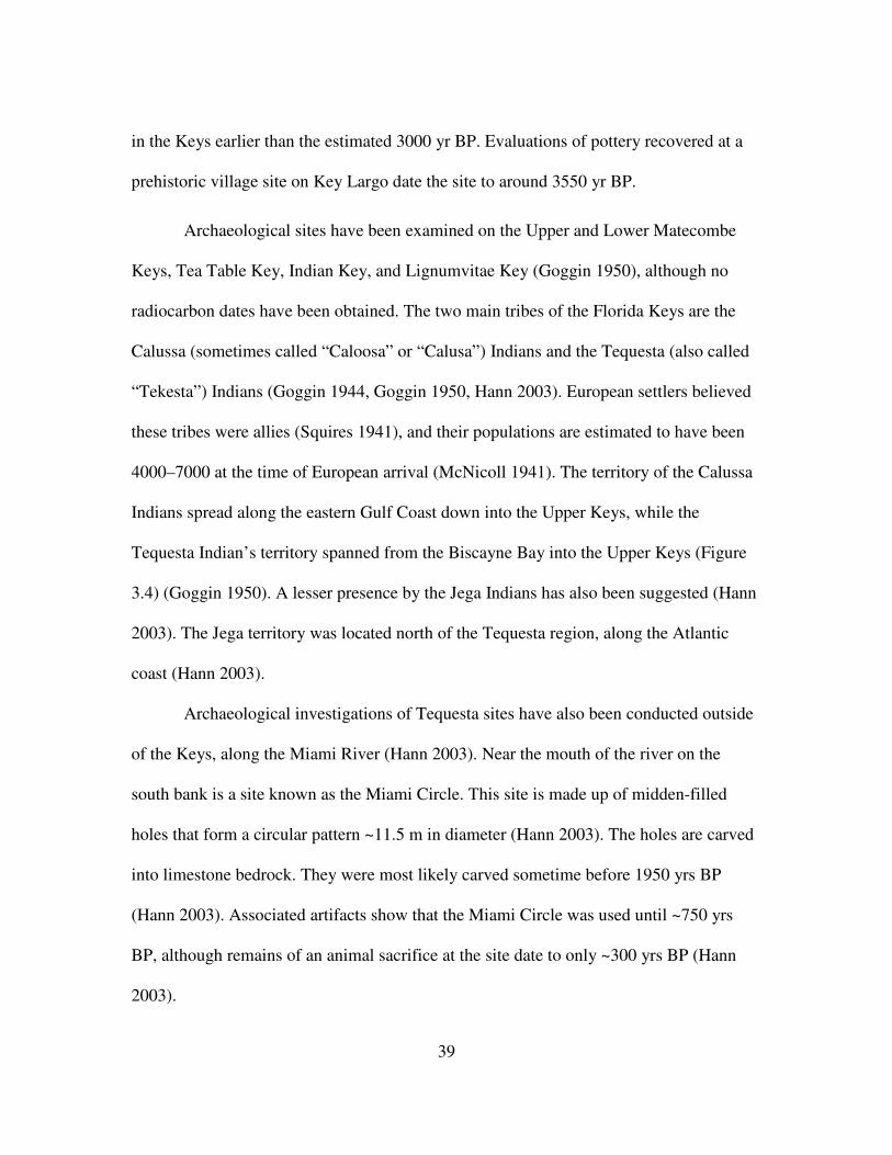
Archaeological sites have been examined on the Upper and Lower Matecombe
Keys, Tea Table Key, Indian Key, and Lignumvitae Key (Goggin 1950), although no
radiocarbon dates have been obtained. The two main tribes of the Florida Keys are the
Calussa (sometimes called “Caloosa” or “Calusa”) Indians and the Tequesta (also called
“Tekesta”) Indians (Goggin 1944, Goggin 1950, Hann 2003). European settlers believed
these tribes were allies (Squires 1941), and their populations are estimated to have been
4000–7000 at the time of European arrival (McNicoll 1941). The territory of the Calussa
Indians spread along the eastern Gulf Coast down into the Upper Keys, while the
Tequesta Indian’s territory spanned from the Biscayne Bay into the Upper Keys (Figure
3.4) (Goggin 1950). A lesser presence by the Jega Indians has also been suggested (Hann
2003). The Jega territory was located north of the Tequesta region, along the Atlantic
coast (Hann 2003).
Archaeological investigations of Tequesta sites have also been conducted outside
of the Keys, along the Miami River (Hann 2003). Near the mouth of the river on the
south bank is a site known as the Miami Circle. This site is made up of midden-filled
holes that form a circular pattern ~11.5 m in diameter (Hann 2003). The holes are carved
into limestone bedrock. They were most likely carved sometime before 1950 yrs BP
(Hann 2003). Associated artifacts show that the Miami Circle was used until ~750 yrs
BP, although remains of an animal sacrifice at the site date to only ~300 yrs BP (Hann
2003).

40
Figure 3.4. General locations of the Calussa (also called, "Caloosa" and "Calusa") Indian and Tequesta (also called, "Tekesta") Indian centers in relation to the Florida Keys. Both of these tribes have been documented in the Keys, primarily in the Upper and Lower Matecumbe Keys (Goggin 1950). Mention of their presence in the Lower Keys was made in the mid-1500s by Hernado de Escalante Fontaneda, who spent years as a Native American captive (Goggin 1950). (Basemap courtesy of Google Maps, 2011).

41
Historic records by Europeans document Native American presence in the Keys
as early as 1551, when Hernando de Escalante Fontaneda noted three settlements
(Goggin 1944, Goggin 1950, Hann 2003). These settlements included the Gaurugube,
Cuchiyaga, and Tatesta (Goggin 1950, Hann 2003). More sites were indicated between
1571 and 1574 by Juan López de Velasco, such as the Matecumbe site (Hann 2003). In
1573, the Spanish documented an attack on them by the Matecumbe village on the Lower
Matecumbe Key (Goggin 1944). Further mention of the Matecumbe site was made in the
1600s by Fontaneda and Bishop Calderón (Goggin 1944). Key West is believed to have
been the last refuge of the Calussa Indians before their disappearance from the Keys in
1763. Native Americans not killed through European violence or foreign disease (Squires
1941) are believed to have sought refuge in Cuba at this time (Hann 2003).
European Settlement
European arrival in the Florida Keys began with brief visits by Ponce de Leon in
1513 and 1522 (Goggin 1950). European settlements on Indian Key, Key West, and Key
Biscayne began around 1750, after the drop-off in Native American population and the
departure of the Spanish (Goggin 1950). The earliest documented colonization on No
Name Key was made about 25 years after Florida became a U.S. State in 1845
(Wilkinson 2011d). The 1870 U.S. Census reported 16 occupied households, seven
unoccupied homes, and 45 inhabitants (Wilkinson 2011d). All of the heads of household,
except for one, were Bahamian immigrants (Wilkinson 2011d). While Key West

42
maintained the largest population in Florida during the 1800s (18,000 residents), the rest
of the Lower Keys remained thinly settled (Wilkinson 2011d).
Political unrest in Cuba led to Cuban patriots being marooned on No Name Key
in the late 1800s (Wilkinson 2011d). This occupation ended by 1898, during the Spanish
American War (Wilkinson 2011d). By the 1910 U.S. Census, only 22 inhabitants
remained on No Name Key. Two major hurricanes swept through the region, further
damaging population on the island. In 1919, a category 4 hurricane struck the Lower
Keys, damaging almost every structure in its path (Barnes 1998, Wilkinson 2011d),
killing 287 people (Blake et al. 2011), and causing more than two million dollars in
damage in Key West (Fort Lauderdale Daily News 1919). The 1935 category 5 hurricane,
also known as the Labor Day Storm, killed 408 people in the Keys (Blake et al. 2011). To
date, the 1935 hurricane is the second most intense hurricane to strike the U.S., preceded
by Hurricane Camille in 1965 and followed by Hurricane Katrina in 2005 (Blake et al.
2011). It is the eighth deadliest hurricane, while the 1919 hurricane is the twelfth
deadliest (Blake et al. 2011). The Labor Day Storm destroyed most of the Upper Keys,
although little damage was noted on No Name Key (Wilkinson 2011a, d). The
transportation routes out of the Keys were significantly damaged (Wilkinson 2011a, d).
Shortly after the Labor Day Storm, mostly because of the destruction of
transportation routes, No Name Key sunk quickly into an uninhabited wildland
(Wilkinson 2011d). The island became resident-free for more than 30 years. Because of
its lack of residents, No Name Key became a popular stop-over point during the Cuban
Revolution, which began in 1959 with General Fidel Castro’s 26th of July Movement

43
overthrowing Cuban President General Fulgencio Batista (Wilkinson 2011d). On
December 5, 1962, a bust on an anti-Castro training camp on No Name Key led to the
arrest of 13 fighters, 10 of whom were Americans (Miami Herald 1962). This group was
led by U.S. Marine Gerald Patrick Hemming (Miami Herald 1962, Wilkinson 2011d).
Another raid on Cuban exile “Freedom Fighters” in April of 1963 led to more arrests,
followed by an April 20th report by the Key West Citizen newspaper that no further
training would be allowed to take place on No Name Key (Wilkinson 2011d).
In 1967, a new bridge between Big Pine Key and No Name Key was opened to
the public (Wilkinson 2011d). Two years later, the island was “resettled” by Bob and
Ruth Eaken and their two children (Wilkinson 2011d). In 1970, two canals were dug on
the island and more than 90 business and residential lots were prepared (Wilkinson
2011d). As of 2009, about 45 homes were occupied on the island (Wilkinson 2011d),
although no public electricity or water supply has been established (Wilkinson 2011d).
Present Condition of the Pine Rockland Ecosystem in the Lower Florida Keys
The pine rocklands of South Florida are considered an endangered plant
community (Synder et al. 2005). It has been estimated that pine rocklands once covered
ca. 65,000 ha in Florida’s Everglades National Park, Big Cypress Preserve, and the
Lower Keys (USFWS 1999, Albritton 2009, Harley et al. 2011). Other pine rockland
communities are found on four islands in the Bahamas and on the Turks and Caicos,
although they are dominated by a different pine species (Pinus caribea var. bahamensis)
(National Key Deer Refuge 2010). Human impact on this ecosystem and its natural fire

44
regime has significantly reduced and fragmented the pine rockland habitat by ~90%
(O’Brien 1998, Synder et al. 2005, Harley et al. 2011). Globally, 98% of pine rockland
communities have been lost because of significant ecological degradation, land-use
conversion, and outright destruction (Noss et al. 1995, Bergh and Wisby 1996, Harley et
al. 2011). The pinelands of the Lower Keys are also threatened by a sea level rise of ca.
15 cm over the last 70 years (Ross et al. 1994, National Key Deer Refuge 2010), as well
as storm surges (National Key Deer Refuge 2010). Because of their coastal proximity and
low elevation, pine rocklands of the Keys are losing ground to the rise in sea level at the
rate of 2.4 cm per decade (Ross et al. 1994, Saha et al 2011). Currently, less than 1000
ha. of pine rockland communities survive in the Keys (Snyder et al. 2005). In 1957, the
National Key Deer Refuge (NKDR) was stabled by the United States Fish and Wildlife
Service (USFWS) to conserve and protect pine rocklands and the endangered Key Deer
that inhabit them (Lopez et al. 2004).
The pine rocklands in the Florida Keys are home to several federally listed plant
and animal species (Coile 2000, Albritton 2009). Threatened and endangered plants
include tiny polygala (Polygala smallii), garber’s spurge (Chamaesyce garberi), coastal
vervain (Verbena maritima), locustberry (Byrsonima lucida), silver palm (Coccothrinax
argentata), cat-tongue (Melanthera parvifolia), deltoid spurge (Chamaesyce deltoidea
spp. deltoidea), and more than 10 other species (USFS 1999, Coile 2000, Albritton 2009).
Federally listed wildlife species include the Key deer (Odocoileus virginianus clavium),
Kirtland’s warbler (Dendroica kirtlandii), ringneck snake (Diadophis punctatus acricus),
and the Florida atala butterfly (Eumaus atala) (USFWS 1999). Invasive plant taxa have

45
significantly affected the pine rocklands of South Florida, with at least 277 exotic plant
taxa currently documented (USFWS 1999).
One of the most studied of the endangered animal species is the Key deer. They
are the smallest subspecies of white-tailed deer in the United States, endemic to the
Florida Keys (Lopez et al. 2004). The deer are present on 20–25 islands, mostly within
the NKDR boundaries (Lopez et al. 2004). Roughly 75% of their population lives on Big
Pine Key and No Name Key (Lopez et al. 2004). Habitat loss and hunting pressure
reduced the Key deer population to ca. 25–50 by the late 1940s (USFWS 1999, Lopez et
al. 2004). After the 1957 establishment of NKDR, their population bloomed to ca. 200
animals on Big Pine Key and No Name Key over 14 years (Lopez et al. 2004). From
1971– 2001, their population on these two islands increased by 240% (Lopez et al. 2004),
although they are still federally listed as endangered. The food sources and browsing
habits of the Key Deer are tied to the fire ecology of the pine rocklands (USFWS 1999,
Barrett 2004).
The exotic Brazilian-pepper tree (Schinus terebinthifolius) is one of the most
invasive plant species that affects the pine rocklands. Significant work regarding exotic
plant species control has been initiated in the Florida Keys pine rocklands (USFWS
1999). In the 1990s, the Department of Environmental Protection (DEP) allocated
$170,000 to exotic species control in the upland regions of the Florida Keys (USFWS
1999). Seven exotic mammals, ~30 birds, 25 reptile, and four amphibian species have
also been introduced to the Lower Keys rocklands, including fire ants (Solenopsis
invicta) and armadillo (Dasypus novemcinctus). The USFWS has recognized the problem

46
of exotic animal introductions and hopes to remove them from all natural areas, as well as
prevent the entry of domestic pets (USFWS 1999).
Although the NKDR used sporadic prescription fires for fuel reduction purposes
starting in 1985, these fires did not take into consideration the natural fire regime or burn
seasons of the pine rocklands (Snyder et al. 1990, Albritton 2009). The NKDR has
recently begun a more comprehensive fire management program (Snyder et al. 1990,
USFWS 1999, Liu and Menges 2005, Albritton 2009). The USFWS and NKDR are
interested in tree-ring and sediment-based reconstructions of past fire, as knowledge
gained can be applied to future wildland management practices and to the education of
Keys residents on the long-term importance of fire in rockland habitats. Charcoal, pollen,
and dendrochronological evidence will document long-term vegetation and fire history,
which will assist restoration and conservation efforts.
Harley (2012) evaluated the influence of historical fire disturbance and fire
management practices on the pine rocklands on Big Pine Key and No Name Key. He
identified and dated fire scars from the past 150 years on two stands of south Florida
slash pine. His findings indicated that fires burned at 6 year intervals on Big Pine Key
and 9 year intervals on No Name Key, with No Name Key experiencing fewer fires. The
majority of fires on both islands occurred late in the growing season (July–November).
Harley (2012) also investigated relationships between historical wildfires and
climate variability using fire-scar chronologies for the period 1707–2010 from four sites
on Big Pine Key. Fires that scarred >50% of the trees occurred during years that were
drier than average and that had experienced lower than average El Niño-Southern

47
Oscillation (ENSO) (NIÑO3.4) values one year prior. His findings suggested a link
between El Niño Decadal Modulation, which affects winter precipitation amounts, and
wildfire. Wetter than average years combined with the positive anomalies of ENSO
strengthened by warm phases of the Pacific Decadal Oscillation increased the growth of
fine fuels, preconditioning widespread fires.
48
CHAPTER 4
Methods
Field Methods
In March 2010, Sally Horn, Henri Grissino-Mayer, Grant Harley, and I examined
multiple solution holes in the NKDR as possible sediment coring sites. Once deemed
appropriate for sampling, a platform was extended over the solution hole, from which we
then collected sediment cores using a Colinvaux-Vohnout locking piston corer
(Colinvaux et al. 1999, Figure 4.1). Three sites were sampled during this field excursion,
unofficially named Coco Plum Pond, Balsa Pond, and Palmetto Pond, resulting in a total
of 24 one-meter core sections. At Coco Plum pond, the coring platform rested on the
edge of a solution hole in which the modern sediment surface was >1 m below the
surrounding rockland. At Balsa and Palmetto Ponds, the platform rested on the damp
surface sediment. Neither site was cored in standing water, though Palmetto Pond had a
slightly deeper area with standing water to the side of our coring platform.
After careful consideration of each site, I decided to focus my research on the
core sections taken from Palmetto Pond on No Name Key (24˚41’45.15”N,
81˚19’43.84”W, Figure 4.2). Balsa Pond yielded the deepest sediment profile, but it may
not be reliable because of potentially major site disturbance. Coco Plum Pond is a
promising site for paleofire research, but it is very close to sites of previous work at Key
Deer Pond and Blue Hole Wetland. I chose Palmetto Pond because I thought it would
make a more interesting comparison with the sites on Big Pine Key (Figure 4.3).

49
Figure 4.1. A sediment core section being retrieved from Palmetto Pond in March 2010. From left to right are Dr. Sally Horn, Grant Harley, and Dr. Henri Grissino-Mayer.
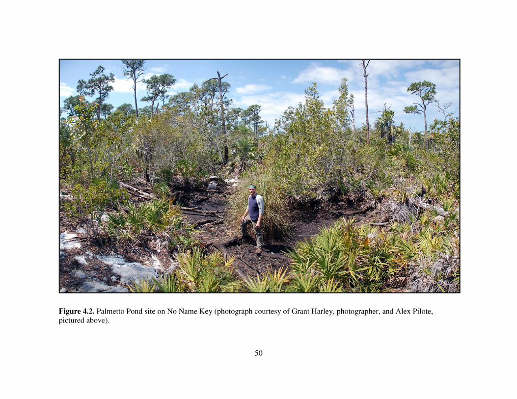
50
Figure 4.2. Palmetto Pond site on No Name Key (photograph courtesy of Grant Harley, photographer, and Alex Pilote, pictured above).
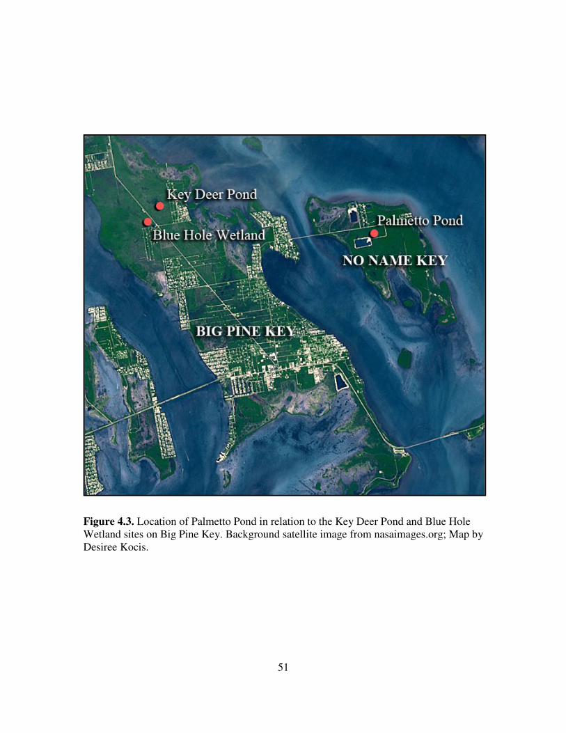
51
Figure 4.3. Location of Palmetto Pond in relation to the Key Deer Pond and Blue Hole Wetland sites on Big Pine Key. Background satellite image from nasaimages.org; Map by Desiree Kocis.
52
Laboratory Methods
In July 2010, Matthew Boehm, Sally Horn, and I used a modified router to open
the aluminum coring tubes containing the Palmetto Pond core sections. Once each core
tube was cut longitudinally, we divided the sediment into two halves using a thin wire.
The halves were labeled A, for archive, and B, for sampling. Next, they were
photographed and described on core logs in terms of the texture, stratigraphy, and
Munsell color. Organic matter concentrations were noted in the core log descriptions.
I sampled the B halves of three successive core sections for macroscopic charcoal
at contiguous 1 cm intervals using a brass sampler with a rectangular cutting edge that
removes samples with a volume of 4 cm3. I placed each sample in a pre-weighed plastic
container, weighed the sample in the container, and added ca 40 ml of 3% hydrogen
peroxide (Schlacter and Horn 2010). I left each container in a fume hood for 24 hours.
The hydrogen peroxide helped to disaggregate the sample and to slightly bleach some
non-charred organic matter, making the charcoal easier to identify, and thereby
improving count accuracy. Next, the samples were carefully wet-sieved through 250,
500, and 1000 µm screens using deionized water. Particles retained on each sieve were
transferred to a Petri dish and left to dry for 24 hours in a drying oven at approximately
100 ˚C. Once dry, the macroscopic charcoal in each dish was counted under a stereo
binocular dissecting scope.

53
Radiocarbon Dating
S. Horn and I selected larger charcoal fragments and one uncharred plant
macrofossil from the Palmetto Pond core sections for AMS radiocarbon dating. The
charcoal fragments dated had been pretreated in H2O2, sieved, dried, and counted before
removal. The macrofossils were dated to determine the chronology of the sediment
profile. Analyses were performed by the Center for Applied Isotope Studies at the
University of Georgia and by Beta Analytic Laboratory in Miami, Florida. The AMS
dates returned were calibrated using CALIB 6.0.2 (Stuiver and Reimer 1993) and the
dataset of Reimer et al. (2009). The weighted means of the probability distributions of
the calibrated radiocarbon dates were used to create an age-depth model using Microscoft
Excel.
Loss-On-Ignition
Adjacent to each 4 cm3 sediment sample for macroscopic charcoal, I removed a 1
cm3 sample for Loss-on-Ignition (LOI) analysis, placed it into a pre-weighed crucible,
and weighed the sample and crucible. The LOI samples were then dried at 100 ˚C for 24
hours and reweighed to determine water content. Samples were ignited for one hour at
550 ˚C in a muffle furnace, weighed, and then ignited again for another hour at 1000 ˚C
(Dean 1974). Once again they were weighed. This LOI analysis allowed me to estimate
the organic, carbonate, and non-carbonate inorganic content of the samples.

54
Macroscopic Charcoal Analysis
Charcoal was identified based on its characteristic black color and sheen, and by
comparison with reference charcoal samples collected at modern burn sites. I classified
charred particles into four categories – wood, seed, stem/twig, and leaf. Stem/twig
charcoal was differentiated from wood charcoal based on its shape. Stem/twig charcoal
was slim, cylindrical, and elongated, while wood charcoal was generally chunky, flatter,
and more rectangular with jagged edges. Charcoal counts for each sieve size and each
sample were compiled into a spreadsheet and used to produce diagrams indicating fire
history trends, possible shifts in climate conditions, and potential Euro-American
settlement impacts.
High resolution charcoal records from lakes in boreal and temperate forests are
often decomposed into background charcoal and charcoal peaks, with peaks representing
fire events (Whitlock and Larsen 2001). Peaks of significance are identified by assigning
a threshold value determined by comparing patterns of charcoal peaks in recent sediments
with knowledge of historic fires near the site (from written records or tree-ring analyses),
through iterative experimentation using different values for thresholds and other variables
(Whitlock and Larsen 2001), or by using various statistical methods of peak detection to
identify fire episodes in data sets, with fire episodes defined as one or more fires
occurring within the sampling resolution of a record (Higuera et al. 2010). None of these
methods seem appropriate for identifying fire episodes at Palmetto Pond, where the
natural fire regime appears to be much more frequent than in other forests where
sedimentary charcoal has been studied. In a recent evaluation of different statistical

55
approaches for decomposing high-resolution charcoal records, Higuera et al. (2010)
explained that efforts to identify fire episodes from sedimentary charcoal are most
promising when fires are large, burn with high severity, and recur on a time scale about
five times the sampling resolution of the charcoal record. Modern circumstances at
Palmetto Pond fall short in all three respects. The small size of the island and its upland
sector mean that fires are small; from the scarring (but survival) of pines, we know the
fires are low rather than high intensity; and based on dendrochronological research
(Harley 2012), the average fire recurrence interval in recent decades and centuries has
been quite a bit less than the sampling resolution of the Palmetto Pond record, which is
ca. 25 years in the top meter.
Thus, the various peak detection methods outlined by Higuera et al. (2010) cannot
be used at Palmetto Pond as they are at sites with much longer fire return intervals.
Instead, I interpreted the fire record by looking for broader trends in charcoal influx
values, which I took to signal periods of greater and lower fire activity rather than
particular fire events. I did, however, use a diagram prepared by Higuera et al. (2010) to
determine when the number of charcoal fragments in one 1-cm sample was statistically
different, at the 99% confidence level, to the number of charcoal fragments in the 1-cm
sample taken from the level below. The diagram (Figure 7 in Higuera et al. 2010)
displays the minimum required increase in charcoal counts required to separate peak from
pre-peak samples as a total number and a proportion. The required increase depends on
the level of confidence desired (95% or 99%) and the number of pieces in the smaller,
pre-peak sample. Curves in the diagram are created from a test for assessing whether two

56
samples are from the same Poisson distribution. Two lines representing significance
levels are shown and presented as absolute counts and percentage increase of the lower
count.
I interpolated the required percentage increase in charcoal from the figure in
Higuera et al. (2010), and then compared that to the actual percentage increase calculated
from the raw charcoal counts in Excel. The required percentage increase necessary to
establish a difference at the 99% level varied from ca. 55% for a particle count of 50
pieces to 20% for a particle count of 300 pieces. I considered the samples that met the test
to represent peaks in charcoal abundance. However, I use the term “peak” differently
than charcoal researchers working at other sites, because I interpreted non-peak samples
to also contain evidence of fires. I also looked for sustained intervals of elevated fire
activity. Each interval began with an elevated value, or peak, at >99% confidence level.
These intervals ended just before the interval in which the charcoal count dropped
sharply, to a count significantly lower than the count at the end of the elevated fire
activity interval.

57
CHAPTER 5
Results
Coring Results
Using 1-m long coring tubes, our coring team recovered six sediment core
sections from three positions (“holes”) in Palmetto Pond. From Holes 1 and 2, we
recovered only incomplete sections of the first meter of sediment. From Hole 3, we
recovered three successive 1 meter long core sections and an overlapping, shorter core
section near the base. For the first core section, we pushed for one meter but recovered
only 77 cm of sediment, either because of compaction or because some sediment did not
enter the core tube. In the second core section from 1 to 2 m we recovered 100 cm of
sediment, and in the third core section from 2 to 3 m we recovered 99 cm of sediment.
The third core section ended on rock. However, by pounding we apparently broke
through the rock to recover an additional short core section. Based on field
measurements, this fourth core section overlapped the material already recovered by ca. 5
cm, covering the interval from 2.95 to ca. 3.35 m. However, because of some uncertainty
about the true degree of overlap of the cores, and time constraints, I did not examine this
core section. The macroscopic charcoal and LOI record that I produced for Palmetto
Pond is based on the first three core sections.
Stratigraphy of Profile
The profile I examined is 3 m long, but has some gaps. The first, from 77–100
cm, may not be a true gap. As above, the 77% recovery we obtained in this first meter

58
may be due to compaction, with no sediments actually missing. A large section of dark
brown to bright, brownish-yellow wood, assumed to be remains of a tree fall, created a
gap in the profile from 110–153 cm (Figure 5.1). A smaller section of bright brownish
yellow wood spans 192–209 cm in the profile. Three rock intrusions (171–181 cm, 220–
227 cm, and 236–256 cm) also exist, and prevented charcoal sampling at those intervals.
From 299–275 cm in Hole 3, the sediment was very wet and rocky, with abundant
carbonate (Munsell 2.5 Y 6/4–2 Y 6/4) (Table 5.1). This section was too dense with rock
to sample. Between 274 and 165 cm, the sediment was not as wet, but still carbonate-rich
and dense with rock fragments (10 YR 2/1–3/2 with 8/2 carbonates) (Table 5.1).
Sediment from 164–0 cm was composed of dark, peaty organics (10 YR 2/1) and did not
contain as much rock or carbonate (Table 5.1).
Radiocarbon Dating
AMS radiocarbon dating of plant material at 247 cm depth in the Palmetto Pond
profile indicates that the record extends from -60 cal yr BP (AD 2010) to 4466 cal yr BP.
Three AMS dates on charcoal higher in the profile are in stratigraphic order (Table 5.2).
A fourth AMS date (1877 cal yr BP) was obtained for a charcoal piece immediately
below a large piece of wood, and appears too young by more than 1000 years (Figure
5.2). This charcoal may have come from charred bark and may represent the time at
which the tree fell onto, and sunk into, the sediment of Palmetto Pond. I considered this
date unreliable and did not use it in estimating sediment ages.
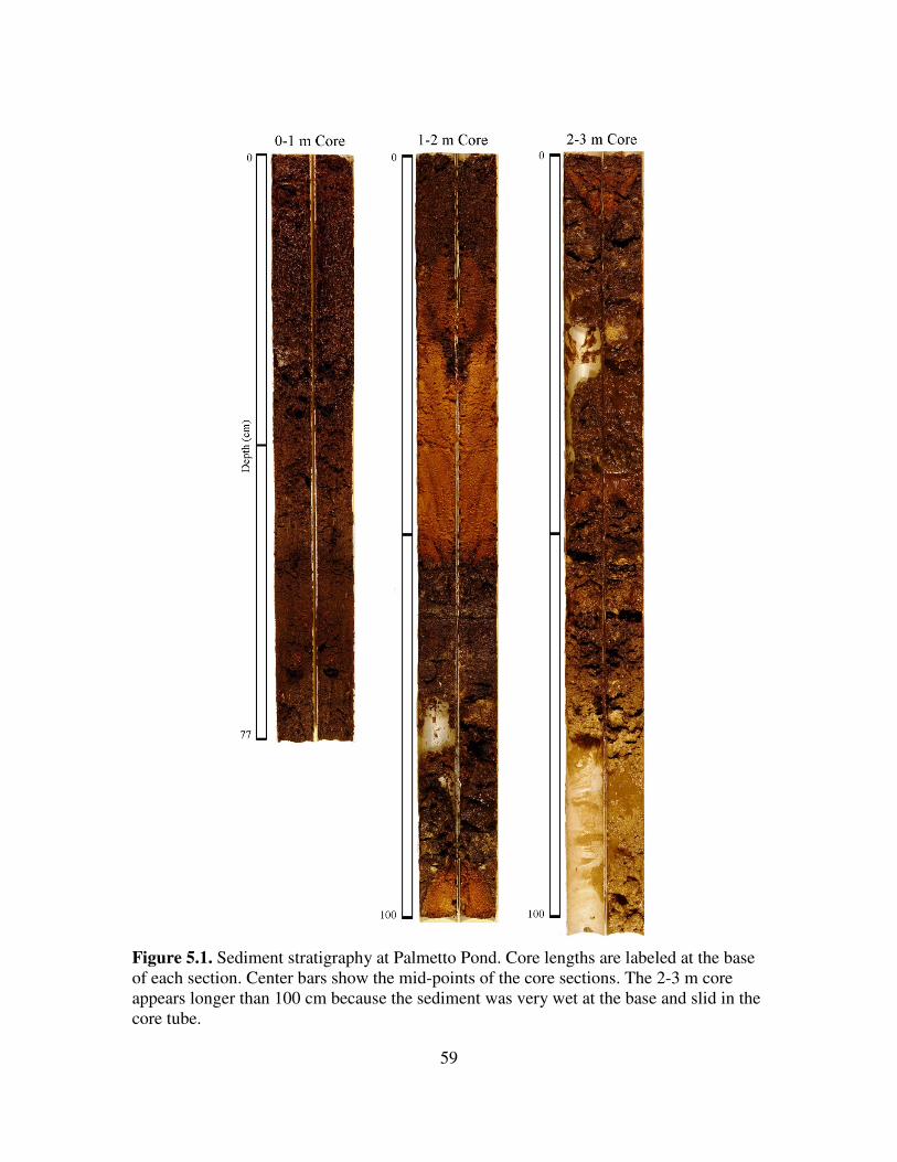
59
Figure 5.1. Sediment stratigraphy at Palmetto Pond. Core lengths are labeled at the base of each section. Center bars show the mid-points of the core sections. The 2-3 m core appears longer than 100 cm because the sediment was very wet at the base and slid in the core tube.

60
Table 5.1. Sediment stratigraphy of the Palmetto Pond profile
Depth Sediment Description Munsell Colors
0–77 cm Peaty sediment with 10 YR 2/1 abundant woody debris
77–100 cm Sediment gap
100–110 cm Organic-rich sediment 10 YR 2/1
110–153 cm Wood, dark brown Not recorded to bright brownish yellow
153–165 cm Wet, organic-rich sediment 10 YR 2/1 to 8/2 intermixed with carbonate
sediments and rock
165–191 cm Wet sediment with low organic 10 YR 2/1 to 8/2 content and abundant rock
191–209 cm Wood, bright brownish yellow Not recorded
209–263 cm Mainly low- organic sediment 10 YR 2/1 to 3/2 with with dense carbonate and 8/2 carbonate
rock debris
263–274 cm Low-organic sediment with 10 YR 2/1 to 6/3 dense carbonate and rock
debris, becoming wetter with depth
274–292 cm Wet, muddy sediment with 2.5 Y 6/4 dense rock debris
292–299 cm Very wet, rocky sediment 2 Y 6/4

61
Table 5.2. AMS radiocarbon determinations and calibrations for samples from the Palmetto Pond profile.
Lab numbera Core section and interval
Depth in profile (cm)
Material dated
δ13C
(‰)
Uncalibrated 14C
age (14C yr BP)
Calibrated age rangeb ± 2 σ
Area under probability
curve
Weighted meanc
UGAMS
#9073 0–1/72–73 cm 72.5 charcoal –26.5 1820±25 1823–1698 1.000 1761
UGAMS
#9074 1–2/9–10 cm 109.5 charcoal –26.6 2350±25
2370–2322 2457–2387
0.810 0.190
2365
β-293749 1–2/55 cm 155.0 charcoal –25.6 1930±30 1947–1820 1.000 1877
UGAMS
#9075 2–3/18–19 cm 218.5 charcoal –26.5 3670±30 4087–3906 1.000 4006
β-282461 2–3/47 cm 247.0 plant
material –24.8 3990±40
4327–4299 4369–4354 4393–4388 4569–4400
0.023 0.014 0.003 0.960
4466
aAnalyses were performed by the Center for Applied Isotope Studies at the University of Georgia (UGAMS), and by Beta Analytic Laboratory in Miami, Florida (β) bCalibrations were calculated using CALIB 6.0.2 (Stuiver and Reimer, 1993) and the dataset of Reimer et al. (2009). cWeighted mean of the 2 σ calibrated radiocarbon probability distribution.

62
Figure 5.2. Age/depth diagram for the Palmetto Pond sediment profile, showing sedimentation rates. The black square indicates the date exluded from analysis. The cal yr BP ages are the weighted means of the probability distributions of the calibrated ages and coring year (top age value).

63
Sedimentation rates were fairly consistent through the profile, varying from 0.040
cm/yr to 0.066 cm/yr (Table 5.2). Sedimentation was slowest (0.04 cm/yr) from 1761–
-60 cal yr BP (AD 189–2010) and fastest (0.066 cm/yr) from 4006–2365 cal yr BP
(2056 –415 BCE). Before 1761 cal yr BP, each centimeter of sediment represents ca. 15–
16 years of accumulation. After this time, each cm represents ca. 25 years.
Loss-On-Ignition
The loss-on-ignition values at Palmetto Pond closely matched up to the visual
stratigraphy of the core (Figure 5.3). Between 258 and 166 cm, the sediment was not very
organic (<50% dry weight). Non-carbonate inorganic content and carbonate content were
high, with values ranging from 38–68% and 11–33%, respectively. Sediment from 165–0
cm was highly organic (>70% dry weight), with lower non-carbonate inorganic content
(<25%) and minimal carbonate content (<3%).
The Macroscopic Charcoal Record
Contiguous sampling of the Palmetto Pond sediment profile revealed that every
centimeter of sediment contained charcoal in at least one of the size classes investigated,
>1000 µm, 500–999 µm, and 250–499 µm. Charcoal concentrations, expressed as
charcoal particles per wet sediment volume, and charcoal influx, expressed as charcoal
particle accumulation per cm2 per year, showed some variation by size class. Total
charcoal concentration and influx values (all particles >250 µm) varied from 4–172.25
particles/cm3 and 0.25–10.67 particles/cm2/yr. Charcoal concentration and influx values
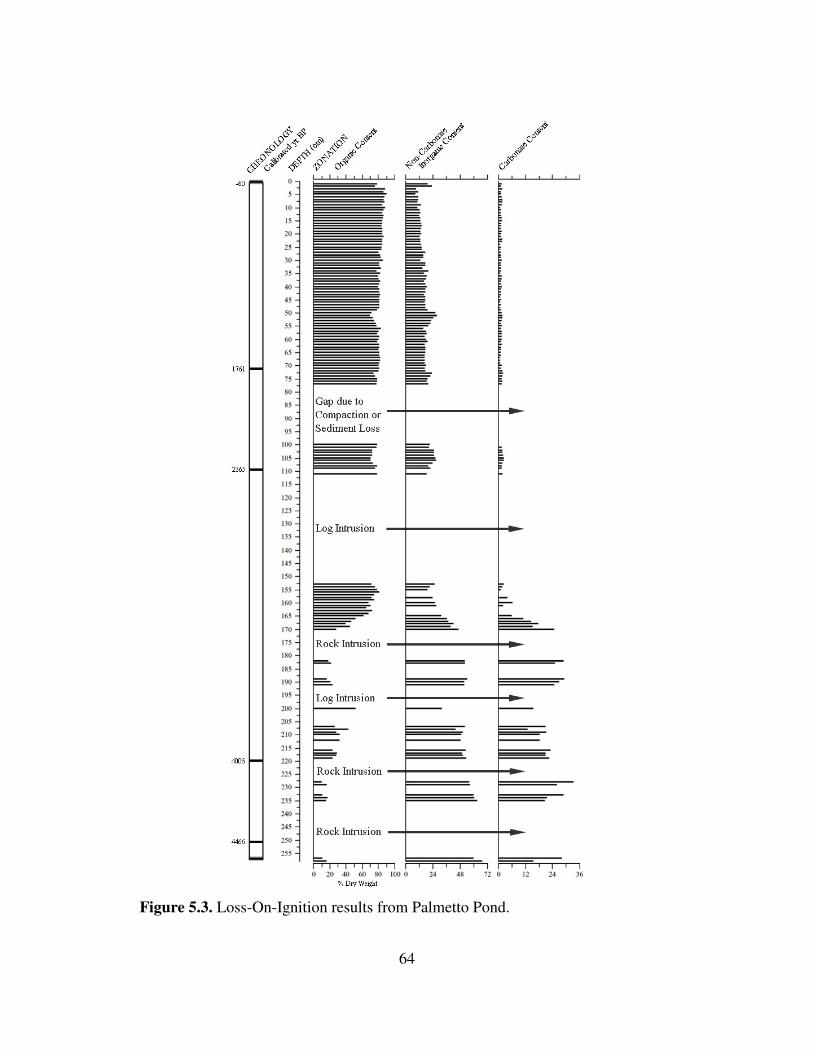
64
Figure 5.3. Loss-On-Ignition results from Palmetto Pond.

65
were elevated between 179 and 53 cal yr BP (9–4 cm) (Figures 5.4 and 5.5). They were
highest from ca. 631–329 cal yr BP (27–15 cm) (Figures 5.4 and 5.5). High values also
occurred from ca. 1794–1736 cal yr BP (74– 71 cm) and from ca. 3268–3208 cal yr BP
(169–165 cm). Thirty-three 1-cm intervals were identified as peaks in charcoal
abundance based on the percentage increase in charcoal from the sample below (Table
5.3, Figure 5.6).
Wood charcoal accounted for more charcoal than any other category examined
(stem/twig, leaf, and seed), with percentages from 4.62–91.43% (Figure 5.7). Stem,
twigs, and other elongated charred plant material made up the next highest percentage,
varying from 0–83.43%. Charred leaf material made up 1.75–71.88% of the total
charcoal count. Seeds were the least dominant charred material, generally accounting for
less than 5% of the charred particles tallied, except for a section with abundant charred
seeds between 45 and 52.5 cm in the sediment profile.

66
Figure 5.4. Macroscopic charcoal concentration and influx values for all size classes at Palmetto Pond, plotted by depth in profile.

67
Figure 5.5. Macroscopic charcoal concentration and influx values for all sizes classes at Palmetto Pond, plotted by interpolated age.

68
Table 5.3. Depth and interpolated age for each sample in the Palmetto Pond record that had statistically more charcoal (99% confidence) than the sample below it, based on values interpolated from Figure 7 in Higuera et al. (2010). These samples were considered charcoal peaks, but at Palmetto Pond samples in between peaks also indicate fires.
Depth (cm) Age (cal yr BP)
2 3 6 103 7 128 9 179 21 480 24 555 26 606 27 631 29 681 32 756 35 832 36 857 38 907 40 957 51 1234 53 1284 56 1359 60 1460 61 1485 65 1585 68 1661 71 1736 72 1761 74 1794 101 2234 103 2267 107 2332 154 3042 156 3073 160 3133 163 3178 169 3268 257 4635

69
Figure 5.6. Total charcoal counts for Palmetto Pond based on samples of 4 cm3 volume. Yellow highlights show 1-cm samples that had statistically more charcoal than the contiguous sample below (“charcoal peaks” in my terminology; see text and Table 5.3). Green highlights show intervals in which higher charcoal abundance can be seen across multiple samples.

70
Figure 5.7. Categories of charred material counted as charcoal, including stem/twigs, wood debris, leaf, and seed. Each category is displayed as a percentage of the total charcoal count of all particles >250 µm in each 4 cm3 sample.

71
CHAPTER 6
Discussion Macroscopic charcoal in the sediment profile from Palmetto Pond provides a ca.
4500-yr record of fire history in pine rocklands on No Name Key. My results
complement and extend previous paleoenvironmental work on fire history in the Lower
Florida Keys, indicate long-term presence of fire in the pine rocklands, document
potential climate effects on fire dynamics, and reveal potential anthropogenic influences
on fire occurrence. Below, I discuss my analysis of the evidence I uncovered regarding
the research questions posed in Chapter One.
What general trends can be determined from the fire history on No Name Key in the
Lower Florida Keys using macroscopic charcoal analysis?
The Palmetto Pond macroscopic charcoal record shows that fire has been a
recurrent element of the rockland ecosystem on No Name Key since at least ca. 4500 cal
yr BP. Every contiguous 1-cm section of the profile contained macroscopic charcoal,
indicating local fires. The minimum number of charcoal fragments was 16 and the
average was 187, attesting to the importance and regularity of fire at the site.
The finding of abundant charcoal throughout the profile is consistent with the
interpretation that pine rocklands of the Lower Keys are a fire-dependent ecosystem
characterized by frequent surface fires (Snyder et al. 1990, Ross et al. 1994, USFWS
1999, Albritton 2009). Fire return intervals in the pine rocklands are estimated at once
every 3–7 years (Snyder 1991, USFWS 1999). Each 1-cm section in the Palmetto Pond

72
profile represents between ca. 15 and 25 yrs, based on my age model. Given this temporal
resolution, the Palmetto Pond record does not provide a basis for testing the long-term
persistence of a 3–7 year fire return interval. However, the presence of charcoal in each
1-cm section suggests the occurrence of at least one fire every ca. 25 years over the last
ca. 1800 years, and every ca. 15 years during the preceding two millennia.
This interpretation is based on the idea that charcoal produced when the
vegetation surrounding Palmetto Pond burns is deposited in the pond during or soon after
the fire, or falls into a crevice or depression in the rockland surface where it is not
available for subsequent transport to the lake. As mentioned previously, researchers who
study fire history from lake sediments in ecosystems with long fire-return intervals often
use computer programs designed to separate charcoal “peaks” (indicating fires) from
“background” charcoal that moves into a lake during fire-free intervals. Because the
estimated fire return interval in pine rocklands, compared to the temporal resolution of
the Palmetto Pond record, falls far short of the ideal value of 5 (instead the value is about
1/5), this type of analysis is not possible with the Palmetto Pond record. But, the shallow
to absent soils of the rockland under conditions of frequent fire, and the abundant pits and
crevices in the rockland surface, suggest that there may not be much background charcoal
influx. This hypothesis needs to be tested by placing sediment traps in rockland ponds or
in some other way monitoring charcoal influx immediately and long after fires.
While it appears inappropriate to recognize peaks in the charcoal record of
Palmetto Pond as individual fires, as every 1-cm interval may potentially record a fire, it
is possible to use variations in charcoal influx to infer periods of greater or lesser fire
73
activity. I identified 33 levels as charcoal peaks that contained significantly more
charcoal than the level below, and visually identified four general intervals of increased
fire activity. Several other smaller intervals of increased fire activity can be visually
assessed from the charcoal diagram, but, unfortunately, many gaps exist in the fire history
record. Some of these inferred intervals of higher fire activity may relate to
anthropogenic impacts or shifts in climate.
Do charcoal influx values reveal any sudden change or changes in fire activity that could
be related to initial human occupation on No Name Key, either by Indigenous
populations or by Euro-Americans beginning the in the 1800s?
Changes in influx values at Palmetto Pond do not definitively reveal initial human
arrival on No Name Key, although they do appear to show more recent effects of humans
on fire history. The archaeological record in the Keys is scant, but Native American
settlement may have begun about 3000 years ago. A long interval of low charcoal
followed by a sustained increase may be indicative of human arrival (Burney et al. 1994,
Burney and Burney 2003). Several statistical peaks in charcoal occur between ca. 3300
and 3000 cal yr BP, but influx values do not show a sustained increase over previous
values. Gaps in the record above and below this interval complicate the detection of a
possible signal of human arrival, and with the data at hand there is no reason to attribute
fires at this time to a human cause.
Charcoal concentration and influx values are highest from ca. 631–329 cal yr BP
(Figure 5.5.). Beginning in the 1500s, historical records by Europeans document Native
74
American presence in the Keys. These dates broadly correspond with the increase in
charcoal at this time, so it is possible that this sustained increase in fire activity may be
related to indigenous impacts on No Name Key.
No Name Key was settled by Bahamians and others beginning around AD 1870
(80 cal yr BP), and occupied by Cubans in the late 1800s. A large spike (2 adjacent
peaks) occurs in the 19th century charcoal record ca. 128 and 103 cal yr BP (AD 1822 and
1847, Figure 5.5), predating the known arrival of settlers. It is possible that this spike
could be attributed to human activity, because some nearby islands, such as Key West,
experienced settlements ca. AD 1750 (200 cal yr BP). However, neighboring Big Pine
Key had minimal human activity (~ 1 occupant) until the 1900s. It does not appear that
human settlement on No Name Key had a strong effect on fire activity, and may have
actually reduced it.
Human presence on No Name Key reduced sharply following the 1935 Labor Day
hurricane and resettlement did not occur until the 1970s. Compared with the previous
1000 years of fire history, the charcoal record takes a large dip beginning shortly after the
time of the hurricane event, in the upper two samples of the record. The interpretation of
the most recent part of the charcoal record as reflecting fewer widespread fires is
consistent with the dendrochronological record of fire history (Harley 2012).

75
How do findings compare with similar sedimentary charcoal work done on Big Pine
Key? How do results compare with ongoing dendrochronological work in the Florida
Keys?
Similarities in charcoal records are seen across the three sites on Big Pine Key
and No Name Key, with all three records having in common the presence of charcoal in
all samples studied. Just as at Palmetto Pond, Blue Hole Wetland and Key Deer Pond
have produced microscopic and macroscopic charcoal records revealing a long, constant
presence of fire in the Lower Keys. The Blue Hole Wetland record covers ca. 2000 years
of fire history, with each centimeter representing ~5 yrs, but was not sampled at high
resolution (Malik 2010). The Key Deer Pond charcoal record extends back to 1660 cal yr
BP, with each cm of sediment representing from ca. 2.5–10 years of accumulation
(Albritton 2009). While the entire profile was sampled for microscopic charcoal, only the
upper ca. 1 m was processed for macroscopic charcoal. The record at Palmetto Pond goes
much further back in time (ca. 4500 cal yrs BP) than these two sites, extending the
evidence for repeated fires through the entire late Holocene. However, the Palmetto Pond
record does not have as fine a temporal resolution (15.2–25 yrs/cm).
Of the five distinct peaks found in the microscopic charcoal record of Key Deer
Pond (18, 177, 357, 548, and 883 cal yr BP, Albritton 2009), all but one (357 cal yr BP)
correspond to times of high macroscopic charcoal influx at Palmetto Pond. Two of the
Blue Hole Wetland peaks (Malik 2010) match peaks at both sites. It is important to note
that these dates are based on interpolated ages that assume constant sedimentation
76
between AMS-dated core intervals, in some cases with large intervals between dates.
Thus, exact correspondence between these records would be unlikely.
The interval of the Palmetto Pond record with the highest charcoal influx values
and inferred highest fire activity occurs between ca. 631–329 yr BP, dips to lower values
for ca. 100 years, then rises again from ca. 179–53 cal yr BP (Figure 5.5). The rises in
activity correspond to times when microscopic charcoal at Key Deer Pond also shows
important peaks, and may be attributed to the Little Ice Age, a time recognized to have
been drier in south Florida (Willard 2006) and the circum-Caribbean (Hodell et al. 2005).
A strong peak at Palmetto Pond seen shortly before AD 1950 is also evident in the
Key Deer Pond microscopic charcoal record (Albritton 2009). The peaks from these two
records may be attributed to the two major hurricane events that struck the Florida Keys
and its surrounding region in 1919 and 1935. Finally, both the Palmetto Pond and Key
Deer Pond records show recent reductions in fire activity. This is likely attributed to fire
suppression practices on the currently inhabited islands.
A similar shift in recent fire activity (since AD 1950) was noted in the tree-ring
records on Big Pine Key and No Name Key (Harley 2012). Harley (2012) identified 13
widespread fires on Big Pine Key, with only three of those recorded since the
establishment of the National Key Deer Refuge in 1957. Those three fire events (AD
1977, 1990, and 2004) are attributed to prescribed burns conducted by fire management
personnel. Only two fire events were recorded at No Name Key since the establishment
of the refuge (1992 and 2003), both of which were prescribed burns. His findings indicate
that after the NKDR establishment, fires became more frequent, but less widespread.

77
Harley also suggested that relatively frequent surface fires prevailed from the 1850s to
the 1950s, a time when increased fire activity was noted in the macroscopic charcoal
records for Key Deer Pond (ca. 110–40 cal yr BP) and Palmetto Pond (ca. 179–53 cal yr
BP). The recent fire history from tree rings shows fewer fires on No Name Key than Big
Pine Key, echoing findings from the macroscopic charcoal record, which shows lower
charcoal influx at Palmetto Pond than Key Deer Pond.
Is there evidence of changes in the fire activity as reflected by charcoal influx during
times of known shifts in climate conditions?
Changes in charcoal influx in the Palmetto Pond record show some relation to
known shifts in regional climate conditions, such as during the Medieval Warm Period
and Little Ice Age. I interpret fires in the pine rocklands prior to European arrival to have
been primarily lightning-induced. Periods of drought can result in greater instances of fire
events due to increased drying of fuels, causing them to be more likely to ignite.
Following generally wet conditions in the middle Holocene, regional climate
became drier beginning 4000–3000 cal years BP, with a marked drying episode from
2400–1500 cal years BP (Hodell et al. 1991, Hodell et al. 2000, Brenner et al. 2001).
Because of the frequency and size of gaps in the charcoal record before 1826 cal yr BP,
associations with regional climate conditions are tenuous for portions of the Late
Holocene. An increase in fire activity occurred from ca. 1843–1761 cal yr BP and was
followed by moderate fire activity until ca. 1183 cal yr BP, around the beginning of the
Medieval Warming Period (MWP) (ca. 1150–750 cal yr BP) began. A peak in charcoal

78
ca. 1485 cal yr BP corresponds with a similar peak found in a sediment core from Abaco
Island, The Bahamas ca. 1500 cal yr BP (West 2007), suggesting a possible period of
regionally high fire activity around this time.
Following the onset of the MWP, a strong decrease in fire activity occurred, with
charcoal influx reaching lowest values between 1158–1007 cal yr BP. Having low fire
activity when regional climates were generally dry seems contradictory. However, Hodell
et al. (2005) identified moist periods within the generally dry interval of the Terminal
Classic drought (ca. 1180–850 yr BP). After ca. AD 1050, climate became drier (Hodell
et al. 1991). The transition to a drier period can be seen in the Palmetto Pond charcoal
record. Fire activity picks up from 1007–731 cal yr BP, coinciding with the driest period
of the Terminal Classic drought (Hodell et al. 2005, Richey et al. 2007). The increased
fire activity that occurred from 631–329 cal yr BP, and peaked 480 cal yr BP, is likely
attributed to the even more extreme drying conditions that began with the Little Ice Age
(450–100 yr BP) (Hodell et al. 2005). The 480 cal yr BP peak in fire activity coincides
with the onset of that dry period. Another large peak ca. 103 cal yr BP (AD 1847) is seen
in the Palmetto Pond charcoal record, as well as in the No Name Key fire record from
tree rings (Harley 2012). This increased burning may relate to drier conditions during the
Little Ice Age.
Strong wind and rain activity during hurricane events result in a sharp increase in
ground leaf litter and other organic debris. This increased fuel load has been linked to
large fires along the Gulf of Mexico coast shortly after major hurricane events (Liu et al.
2003, Liu et al. 2008). Evidence of this hurricane-fire correlation may be present in the

79
Palmetto Pond charcoal record. In 1935, the second strongest hurricane to make landfall
in U.S. history struck southeastern Florida (Blake et al. 2011, Wilkinson 2011a). The
Labor Day Hurricane, as it was called, was a category 5 storm that brought peak wind
speeds of 295 km/hr (185 mi/hr) (Blake et al. 2011, Wilkinson 2011a). Higher charcoal
influx at Palmetto Pond shortly before AD 1950 (in the 2–3 cm sample) may be attributed
to this storm, giving greater credibility to the hurricane-fire correlation argument. The
tree-ring record of past fires on No Name Key shows definite evidence of burning near
Palmetto Pond in 1936 (Harley 2012). These post-hurricane fire or fires cannot be
attributed to human activity on No Name Key because the island was largely uninhabited
from 1935–1970. European settlers employed fire suppression techniques until the
establishment of NKDR, so it is possible that the abandonment on No Name Key by
humans ca. 1935 actually resulted in a larger fire event, or greater increase in fire activity,
than would have occurred if they had remained on the island.
Loss-on-ignition analysis is a valuable tool for detecting overwash sand layers
and lithological changes in lake sediment cores related to hurricane events (Liu and Fearn
2000, Liu et al. 2008). Thick sections of organic material can indicate the increased leaf
litter load that follows major hurricanes (Whelan and Smith 2006, Liu et al. 2008).
Charcoal peaks immediately above these thick layers suggest hurricane-related fire events
(Liu et al. 2008). A small peak in the proportion of charcoal from leaves in the Palmetto
Pond record is not seen in the sample with the charcoal peak I associate with the 1936
fire, but is seen in the sample above.

80
A large increase in the proportion of charcoal from leaf litter occurred in the
record between 1661–1434 cal yr BP. At this time, the proportion of charcoal from wood,
stems/twigs, and seeds is low. While four peaks in the charcoal record are seen during
this period (1460, 1485, 1585, and 1661), no sustained increase in overall charcoal
concentration or influx occurs. Hurricane records are not available from the Florida Keys
for this period, but based on studies that show that increased leaf litter follows major
hurricanes (Whelan and Smith 2006, Liu et al. 2008), I interpret this increase in charred
leaf pieces as possible evidence of heightened hurricane activity. The timing of the
increase in charred leaf litter is interesting in that it comes near a time of transition from
dry to moist conditions at sites in the circum-Caribbean region (Hodell et al. 2000).
81
CHAPTER 7
Conclusions
The Palmetto Pond record provides a ca. 4500-year history of fire in pine
rocklands on No Name Key, Florida. Macroscopic charcoal was found in every interval
of this record and similar records on Big Pine Key, adding weight to previous assertions
that pine rocklands are characterized by frequent fires. Fluctuations in the macroscopic
charcoal record from Palmetto Pond show some association with climate shifts during the
Late Holocene. A powerful 1935 hurricane appears to be shown in the charcoal and tree-
ring records at No Name and Big Pine Keys. This finding suggests that future inference
concerning hurricane activity in pine rocklands may be made using similar proxy records
from lake-sediment profiles. A sustained increase in the proportion of charcoal from
leaves in the Palmetto Pond record from 1661–1434 cal yr BP may be indicative of
heightened hurricane activity.
It is believed that prehistoric, large-group settlements on the Keys began ca. 3000
yrs BP. Several statistical peaks in charcoal abundance occur between 3300 and 3000 cal
yr BP, but equivalent charcoal levels lower in the profile and gaps in the sediment profile
after this time lead me to reject the idea that these peaks are related to the initial arrival of
Native Americans on No Name Key. A sustained increase in charcoal concentration and
influx values ca. 631–329 cal yr BP is more likely to be attributed to indigenous activity,
although it may also be attributed to the drying effects of the Little Ice Age. The fire
history of No Name Key was not likely affected by non-Indigenous people (e.g.

82
Europeans, Bahamians, Cubans, or Americans) until the 1900s, when the practice of fire
suppression appeared to decrease fire occurrence.
That the pine rocklands on No Name Key are considered endangered because of
rises in sea level, urbanization, and human impacts on the natural fire regime makes the
continuation of this line of fire history research essential for strengthening preservation
efforts in the pine rockland communities within the NKDR, as well as in other locations
in southern Florida and The Bahamas. These studies offer a long-term perspective on fire
history for this endangered ecosystem, information that can help managers develop
appropriate land management practices. These studies may also help educate local land
owners, many of whom currently do not understand or accept the use of prescribed fires
in the region, seeing them as both destructive and a burden.
Pollen analysis of the Palmetto Pond sediments would be useful for showing
whether changes in vegetation have occurred on No Name Key, and could complement
and strengthen interpretations of the charcoal record at this site. Future research on the
2010 sediment cores from Coco Plum and Balsa ponds on Big Pine Key will help verify
some of my interpretations of the macroscopic charcoal record. Additional insights into
the fire history of the pine rocklands in the Lower Keys could also be provided by
continued sampling of the macroscopic charcoal record at Key Deer Pond. Obtaining
more radiocarbon dates at Palmetto Pond will strengthen the chronology of the fire
record. Meanwhile, dendrochronological research on fire history on No Name Key
confirms the recent downturn in fire activity suggested by the decline in charcoal influx
in the uppermost sediments of Palmetto Pond. More effort to link tree-ring and sediment

83
records of fire in the Keys would be worthwhile. The findings from sediment and tree-
ring studies can together form a comprehensive body of research that can be used by the
USFWS and NKDR to develop management practices in the pine rocklands.

84
REFERENCES

85
Abrahamson, W.G. and Abrahamson, C.R. 1996. Effects of fire on long-unburned Florida uplands. Journal of Vegetation Science 7(4): 565–574. Albritton, J.W. 2009. A 1700-year history of fire and vegetation in pine rocklands of National Key Deer Refuge, Big Pine Key, Florida: Charcoal and pollen evidence from Key Deer Pond. M.S. Thesis, Department of Geography, University of Tennessee, Knoxville. Alexander, T.R. 1967. A tropical hammock on the Miami (Florida) limestone – a twenty-five year study. Ecology 48(5): 863–867. Alexander, T.R., and Dickson, J.D. III. 1972. Vegetation changes in the National Key Deer Refuge-II. Quarterly Journal of Florida Academy of Sciences 35: 85–96. Anchukaitis, K.J. and Horn, S.P. 2005. A 2000 year reconstruction of forest disturbance from southern Pacific Costa Rica. Palaeogeography, Palaeoclimatology, Palaeoecology
221: 35–54. Arford, M. 2007. Middle to late Holocene environmental change and human impacts in seasonally dry neotropical forest of northwestern Costa Rica: Sedimentary evidence from six lakes. Ph.D. Dissertation, Department of Geography, University of Tennessee, Knoxville. Bal, M., Pelachs, A., Perez-Obiol, R., Julia, R., and Cunill, R. 2011. Fire history and human activities during the last 3300 cal yr BP in Spain’s Pyrenees: The case of the Estany de Burg. Palaeogeography, Palaeoclimatology, Palaeoecology 300: 179–190. Barnes, J. 1998. Florida’s Hurricane History. Chapel Hill: UNC Press. Barrett, M.A. 2004. An analysis of Key Deer herbivory on forest communities in the Lower Florida Keys. Ph.D. Dissertation, Department of Biology, University of South Florida, Tampa. Barrett, M.A., Stiling, P., and Lopez, R.R. 2006. Long-term changes in plant communities influenced by Key Deer herbivory. Natural Areas Journal 26: 235–243. Beckage, B. and Stoute, I.J. 2000. The effects of repeated burning on species richness in Florida sandhills: A test of the intermediate disturbance hypothesis. Journal of Vegetation
Science 11: 113–122. Beckage, B. and Platt, W.J. 2003. Predicting severe wildfire years in the Florida Everglades. Frontiers in Ecology and the Environment 1(3): 235–239.
86
Bergh, C. and Wisby, J. 1996. Fire history of lower Keys pine rocklands. The Nature Conservancy, Florida Keys Initiative, Key West, FL. Pp. 23. Bernhardt, C.E., Willard, D.A., Marot, M., and Holmes, C.W. 2004. Anthropogenic and natural variation in ridge and slough pollen assemblages. USGS Open File Report OFR 2004–1448: Pp. 47. Blake, E.S., Landsea, C.W., and Gibney, E.J. 2011. The deadliest, costliest, most intense United States tropical cyclones from 1851–2010 (and other frequently requested hurricane facts). National Weather Service and National Hurricane Center, Miami, Florida: NOAA Technical Memorandum NWS NHC-6. August 2011. Brenner, M., Hodell, D., Curtis, J., Rosenmeier, M., Binford, M., and Abbott, M. 2001. Abrupt climate change and pre-Columbian cultural collapse. In Markgraf, V. (Ed.), Interhemispheric Climate Linkages. San Diego, California: Academic Press. Pp. 87–103. Brenner, M., Rosenmeier, M.F., Hodell, D.A., and Curtis, J.H. 2002. Paleolimnology of the Maya Lowlands: Long-term perspective on interactions among climate, environment, and humans. Ancient Mesoamerica 13: 141–157. Burney, D.A. 1999. Rates, patterns, and processes of landscape transformation and extinction in Madagascar. In MacPhee, R.D.E. (Ed.), Extinctions in Near Time, Kluwer Academic/Plenum Publishers, New York, Pp. 145–164. Burney, D.A. and Burney, L.P. 2003. Charcoal stratigraphies for Kaua’i and the timing of human arrival. Pacific Science 57(2): 211–226. Burney, D.A. and Burney, L.P. 2007. Paleoecological and “inter-situ” restoration on Kauaʽi, Hawaii. Frontiers in Ecology and the Environment 5(9): 483–490. Burney, D.A., Burney, L.P., Godfrey, L.R., Jungers, W.L., Goodman, S.M., Wright, H.T., and Jull, A.J.T. 2004. A chronology for late prehistoric Madagascar. Journal of
Human Evolution 47(1–2): 25–63. Burney, D.A., Burney, L.P., and MacPhee, R.D.E. 1994. Holocene charcoal stratigraphy from Laguna Tortuguero, Puerto Rico, and the timing of human arrival on the island. Journal of Archaeological Science 21: 273–281. Carlson, P.C., Tanner, G.W., and Humphrey, S.R. 1993. Fire in Key Deer habitat improves, prevents succession, and preserves endemic herbs. Journal of Wildlife
Management 57(4): 914–928.

87
Chambers, F.M., Mauquoy, D., and Todd, P.A. 1999. Recent rise to dominance of Molinia caerulea in environmentally sensitive areas: New perspectives from paleoecological data. Journal of Applied Ecology 36: 719–733. Clark, R.L. 1982. Point count estimation of charcoal in pollen preparations and thin sections of sediments. Pollen et Spores 24: 523–535. Clark, R.L. 1984. Effects on charcoal of pollen preparation procedures. Pollen et Spores
26: 559–579. Clark, J.S., Lynch J., Stocks, B.J., and Goldammer, J.G. 1998. Relationships between charcoal particles in air and sediments in west-central Siberia. Holocene 8(1): 19–29. Clement, R.M. and Horn, S.P. 2001. Pre-Columbian land-use history in Costa Rica: A 3000 year record of forest clearance, agriculture, and fires from Laguna Zoncho. The
Holocene 11(4): 419–426. Colie, N.C. 2000. Notes on Florida’s endangered and threatened plants. Florida Department of Agriculture and Consumer Services. Bureau of Entomology, Nematology and Plant Pathology, Botany Section 28: 1–122. Colinvaux, P.A., De Oliveira, P.E., and Moreno, J.E. 1999. Amazon Pollen Manual and
Atlas. Amsterdam: Harwood Academic Publishers. Dean, W.E. 1974. Determination of carbonate and organic-matter in calcareous sediments and sedimentary-rocks by loss on ignition - comparison with other methods. Journal of
Sedimentary Petrology 44: 242-248. Douglas, M. 1947. The Everglades: River of Grass. New York: Rinehart. Enfield, D.B., Mestas-Nuñez, A.M., and Trimble, P.J. 2001. The Atlantic multidecadal oscillation and its relation to rainfall and river flows in the continental U.S. Geophysical
Research Letters 28(10): 2077–2080. Fort Lauderdale Daily News. Little Damage Done Here By Wind Storm. September 12, 1919. Gardner, J.J. and Whitlock, C. 2001. Charcoal accumulation following a recent fire in the Cascade Range, northwestern USA, and its relevance for fire-history studies. The
Holocene 11(5): 541–549. Gavin, D.G., Hallett, D.J., Hu, F.S., Lertzman, K.P., Prichard, S.J., Brown, K.J., Lynch, J.A., Bartlein, P., and Peterson, D.L. 2007. Forest fire and climate change in western

88
North America: Insights from sediment charcoal records. Frontiers in Ecology and the
Environment 5(9): 499–509. Glitzenstein, J.S., Platt, W.J., and Streng, D.R. 1995. Effects of fire regime and habitat on tree dynamics in north Florida longleaf pine savannas. Ecological Monographs 65: 441–476. Goggin, J.M. 1944. Archaeological investigations on the Upper Florida Keys. Tequesta 1(4): 13–35. Goggin, J.M. 1950. The Indians and the history of the Matecumbe region. Tequesta
1(10): 13–35. Goldenberg, S.B., Landsea, C.W., Mestas-Nuñez, A.M, and Gray, W.M. 2001. The recent increase in Atlantic hurricane activity: Causes and implications. Science 293: 474–479. Grimm, E.C., Jacobson, G.L. Jr., Watts, W.A., Hansen, B.C.S., and Maasch, K.A. 1993. A 50,000 year record climate oscillations from Florida and its temporal correlation with Heinrich Events. Science 261: 198–200. Hann, J.H. 2003. Indians of Central and South Florida, 1513–1763. Gainesville, Florida: University Press of Florida. Harley, G.L. 2012. Tree growth dynamics, fire history, and climate-fire relationships in pine rocklands of the Florida Keys, U.S.A. Ph.D. Dissertation, Department of Geography, University of Tennessee, Knoxville. Harley, G. L., Grissino-Mayer, H.D., and Horn, S.P. 2011. The dendrochronology of Pinus elliottii in the Lower Florida Keys: Chronology, development, and climate response. Tree-Ring Research 67(1): 39–50. Harveson, P.M., Lopez, R.R., Collier, B.A., and Silvy, N.J. 2007. Impacts of urbanization on Florida Key Deer behavior and population dynamics. Biological Conservation 134: 321–331. Heyerdahl, E.K. and Card, V. 2000. Implications of paleorecords for ecosystem management. Trends in Ecology and Evolution 15(2): 49–50. Higuera-Gundy, A., Brenner, M., Hodell, D.A., Curtis, J.H., Leyden, B.W., and Binford, M.W. 1999. A 10,300 14C yr record of climate and vegetation change from Haiti. Quaternary Research 52: 159–170.
89
Higuera, P.E., Gavin, D.G., Barlein, P.J., and Hallett, D.J. 2010. Peak detection in sediment-charcoal records: Impacts of alternative data analysis methods on fire-history interpretations. International Journal of Wildland Fire 19: 996–1014. Hodell, D.A., Brenner, M., and Curtis, J.H. 2000. Climate change in the northern American tropics and subtropics since the last ice age. In Lentz, D.L. (Ed.). Landscape
Transformations in the Precolumbian Americas. Columbia University Press, New York, Pp. 13–38. Hodell, D.A., Brenner, M., and Curtis. J.H. 2005. Terminal Classic drought in the northern Maya lowlands inferred from multiple sediment cores in Lake Chichancanab (Mexico). Quaternary Science Reviews 24(12–13): 1413–1427. Hodell, D.A., Curtis, J.H., Jones, G.A., Higuera-Gundy, A., Brenner, M., Binford, M.W., and Dorsey, K.T. 1991. Reconstruction of Caribbean climate change over the past 10,500 years. Nature 352: 790–793. Hoffmeister, J.E. and Multer, H.G. 1968. Geology and origin of the Florida Keys. Geological Society of America Bulletin 79: 1487–1502. Horn, S.P. 1989. Prehistoric fires in the Chirripó highlands of Costa Rica: Sedimentary charcoal evidence. Revista de Biologia Tropical 37: 139–148. Horn, S.P. 1993. Postglacial vegetation and fire history in the Chirripó Páramo of Costa Rica. Quaternary Research 40(1): 107–116. Horn, S.P. 1998. Fire management and natural landscapes in the Chirripó Páramo, Chirripó National Park, Costa Rica. In Zimmerer, K. and Young, K. (Eds.). From
Nature’s Geography. Biogeographical Landscapes and Conservation in Developing
Countries. Madison, Wisconsin: University of Wisconsin Press, Pp. 125–146. Horn, S.P. 2008. Sediment records of fire and vegetation history from solution holes in the National Key Deer Refuge, Monroe County, Florida. Report on Research Funded by the U.S. Fish and Wildlife Service, Submitted to the National Key Deer Refuge, Anne Morkill, Director. Horn, S.P. and Sanford, R.L. Jr. 1992. Holocene fires in Costa Rica. Biotropica 24(3): 354–361. Ish-Shalom, N., da Silveira Lobo Sternberg, L., Ross, M., O’Brien, J., and Flynn, L. 1992. Water utilization of tropical hardwood hammocks of the Lower Florida Keys. Oecologia 92(1): 108–112.

90
Kaplan, S.W. 2003. Peat records of late Holocene climate and sea level change in South Florida. Ph.D. Dissertation, Department of Geography, University of Wisconsin, Madison.
Keim, B.D., Muller, R.A., and Stone, G.W. 2004. Spatial and temporal variability of coastal storms in the North Atlantic Basin. Marine Geology 210: 7–15. Kjellmark, E. 1995. The effects of Late Holocene climate change and human disturbance on the vegetation and fire history of Andros Island, Bahamas. Ph.D. Dissertation, Department of Botany, Duke University. Kjellmark, E. 1996. Late Holocene climate change and human disturbance on Andros Island, Bahamas. Journal of Paleolimnology 15: 133–145. Kwon, H., U. Lall, Y. Moon, A.F. Khalil, and Ahn, H. 2006. Episodic interannual climate oscillations and their influence on season rainfall in the Everglades National Park. Water
Resources Research 42: W11404. Laird, L.D. and Campbell, I.D. 2000. High resolution palaeofire signals from Christina Lake, Alberta: A comparison of the charcoal signals extracted by two different methods. Palaeogeography, Palaeoclimatology, Palaeoecology 164(1–4): 111–123. Lane, C.S., Horn, S.P., Mora, C.I., and Orvis, K.H. 2009. Late-Holocene paleoenvironmental change at mid-elevation on the Caribbean slope of the Cordillera Central, Dominican Republic: A multi-site, multi-proxy analysis. Quaternary Science
Reviews 28(2009): 2239–2260. League, B.L. 2003. Patterns of recent charcoal accumulation in sediments of a glacial lake in the páramo of Parque Nacional Chirripó, Costa Rica. MS Thesis, Department of Geography, University of Tennessee, Knoxville. League, B.L. and Horn, S.P. 2000. A 10,000-year record of páramo fires in Costa Rica. Journal of Tropical Ecology 16: 747–752. Lidz, B.H. and Shinn, E.A. 1991. Paleoshorelines, reefs, and a rising sea: south Florida, U.S.A. Journal of Coastal Research 7(1): 203–229. Liu, H. and Menges, E.S. 2005. Winter fires promote greater vital rates in the Florida Keys than summer fires. Ecology 86(6): 1483–1495. Liu, K. and Fearn, M.L. 1993. Lake-sediment record of late Holocene hurricane activities from coastal Alabama. Geology 21: 793–796.

91
Liu, K. and Fearn, M.L. 2000. Reconstruction of prehistoric landfall frequencies of catastrophic hurricanes in northwestern Florida from lake sediment records. Quaternary
Research 54: 238–245. Liu, K., Lu, H.Y., and Shen, C.M. 2003. Assessing the vulnerability of the Alabama Gulf Coast to intense hurricane strikes and forest fires in the light of long-term climatic changes. In Nigh, Z.H. and Abdullahi, K.K. (Eds.), Current stresses and potential
vulnerabilities: implications of glocal change for the Gulf Coast region of the United
States. Gulf Coast Climate Change Council and Franklin Press, Baton Rouge, Louisiana, Pp. 223–230. Liu, K., Lu, H.Y., and Shen, C.M. 2008. A 1200-year proxy record of hurricanes and fires from the Gulf of Mexico coast: Testing the hypothesis of hurricane-fire interactions. Quaternary Research 69: 29–41. Loehle, C., Wigley, T.B., Schilling, E., Tatum, V., Beebe, J., Vance, E., Van Deusen, P., and Weatherford, P. 2009. Achieving conservation goals in managed forests of the southeastern coastal plain. Environmental Management 44: 1136–1148. Long, C.J., Whitlock, C., Bartlein, P.J., and Millspaugh, S.H. 1998. A 9000-year fire history from the Oregon Coast Range, based on high–resolution charcoal study. Canadian Journal of Forest Research 28(5): 774–787. Longshore, D. 2008. Encyclopedia of Hurricanes, Typhoons and Cyclones. Infobase Publishing, New York City, New York. Lopez, R.R., Silvy, N.J., Labisky, R.F., and Frank, P.A. 2003. Hurricane impacts on Key Deer in the Florida Keys. Journal of Wildlife Management 67(2): 280–288. Lopez, R.R., Silvy, N.J., Wilkins, R.N., Frank, P.A., Peterson, M.J., and Peterson, M.N. 2004. Habitat-use patterns of Florida Key Deer: Implications of urban development. Journal of Wildlife Management 68(4): 900–908. Lugo, A.E. 2000. Effects and outcomes of Caribbean hurricanes in a climate change scenario. The Science of the Total Environment 262: 243–251. Lynch, J.T. 1941. The place of burning in management of the Gulf Coast wildlife Refuges. Journal of Wildlife Management 5(4): 454–457. Main, M.B. and Richardson, L.W. 2002. Response of wildlife to prescribed fire in southwest Florida pine flatwoods. Wildlife Society Bulletin 30(1): 213–221.

92
Malik, J. 2010. A long term fire history from sedimentary charcoal in a small wetland on Big Pine Key, Florida, USA. Senior Honors Thesis, Department of Geography, University of Tennessee. Maxwell, A.L. 2004. Fire regimes in north-eastern Cambodian monsoonal forests, with a 9300-year sediment charcoal record. Journal of Biogeography 31(2): 225–239. McNicoll, R.E. 1941. The Caloosa Village Tequesta: A Miami of the sixteenth century. Tequesta 1(14): 11–20. Menges, E.S. and Kohfeldt, N. 1995. Life history strategies of Florida scrub plants in relation to fire. Bulletin Torrey Botanical Club 122: 282–297. Miami Herald. U.S. Nabs Anti-Castro Fighters- Why? December 5, 1962: 21. Millspaugh, S.H., Whitlock, C., and Bartlein, P.J. 2000. Variations in fire frequency and climate over the past 17,000 years in central Yellowstone National Park. Geology 28(3): 211–214. Multer, H.G. and Hoffmeister, J.E. 1968. Subaerial laminated crusts of the Florida Keys. Geological Society of America Bulletin 79: 182–192. Myers, R.L. 2000. Fire in tropical and subtropical ecosystems. In Brown, J.K. and Smith, J.K. (Eds.), Wildland Fire in Ecosystems: Effects of Fire on Flora. USDA Forest Service Gen. Tech. Rep RMRS–GTR–42. Vol. 2. National Key Deer Refuge. 2010. Report. National Key Deer Refuge – desired future conditions for fire-maintained habitats. Results and synthesis of a Fire Management and Fire Ecology Expert’s workshop. August 16–17, 2010. Pp. 1–61. Neary, D.G., Klopatek, C.C., DeBano, L.F., and Ffolliott, P.F. 1999. Fire effects on belowground sustainability: A review and synthesis. Forest Ecology and Management 122: 51–71. Northrop, L.A. and Horn, S.P. 1996. Pre-Columbian agriculture and forest disturbance in Costa Rica: Palaeoecological evidence from two lowland rainforest lakes. The Holocene
6(3): 289–299. Noss, R.F., LaRoe, E.T. III, and Scott, J.M. 1995. Endangered ecosystems of the United States: A preliminary assessment of loss and degradation. USDI. NBS. Biological Report 28. Washington, DC. Obeysekera, J., Browder, J., Hornung, L., and Harwell, M.A. 1999. The natural south Florida system I: Climate, geology, and hydrology. Urban Ecosystems 3: 223–244.
93
O’Brien, J.J. 1998. The distribution and habitat preferences of rare Galactia species (Fabaceae) and Chamaesyce deltoidea subspecies (Euphorbiaceae) native to southern Florida pine rockland. Natural Areas Journal 18: 209–222. Ohlson, M. and Tryterud, E. 2000. Interpretation of the charcoal record in forest soils: Forest fires and their production and deposition of macroscopic charcoal. The Holocene
10(4): 519–525. Patterson, W.A., Edwards, K.J., and Maguire, D.J. 1987. Microscopic charcoal as a fossil indicator of fire. Quaternary Science Reviews 6(1): 3–23. Platt, W.J., Doren, R.F., and Armentano, T.V. 2000. Effects of Hurricane Andrew on stands of slash pine (Pinus elliottii var. densa) in the everglades region of south Florida (USA). Plant Ecology 146: 43–60. Platt, W.J., Evans, G.W., and Davis, M.M. 1988. Effects of fire season on flowering of forbs and shrubs in longleaf pine forests. Oecologia (Berl.) 76: 353–363. Pimm, S.L., Davis, G.E., Loope, L., Roman, C.T., Smith, T.J. III, and Tilmant, J.T. 1994. Hurricane Andrew. BioScience 44(4): 224–229. Reimer, P. J., Baillie, M. G. L., Bard, E., Bayliss, A., Beck, J. W., Blackwell, P. G., Ramsey, C. B., Buck, C. E., Burr, G. S., Edwards, R. L., Friedrich, M.l; Grootes, P. M., Guilderson, T. P., Hajdas, I., Heaton, T. J., Hogg, A. G., Hughen, K.A., Kaiser, K. F., Kromer, B., McCormac, F. G., Manning, S. W., Reimer, R. W., Richards, D. A., Southon, J. R., Talamo, S., Turney, C. S. M., van der Plicht, J., and Weyhenmeyer, C. E. 2009. IntCal09 and Marine09 radiocarbon age calibration curves, 0–50,000 years cal BP. Radiocarbon 51(4): 1111–1150. Richey, J.N., Poore, R.Z., Flower, B.P., and Quinn, T.M. 2007. 1400 yr multiproxy record of climate variability from the northern Gulf of Mexico. Geology 35(5): 423–426. Ross, M.S., Coultas, C., and Hsieh, Y.P. 2003. Soil-productivity relationships and organic matter turnover in dry tropical forests of the Florida Keys. Plant Soil 253: 479–492. Ross, M.S., O’Brien, J.J., and Flynn, L.J. 1992. Ecological site classification of Florida Keys terrestrial habitats. Biotropica 24(4): 488–502. Ross, M.S., O’Brien, J.J., and Sternberg, L. 1994. Sea-level rise and the reduction in pine forests in the Florida Keys. Ecological Applications 4(1): 144–156.

94
Ross, M.S., Ruiz, P.L, Sah, J.P., Reed, D.L., Walters, J., and Meeder, J.F. 2006. Early post-hurricane stand development in fringe mangrove forests of contrasting productivity. Plant Ecology 185: 283–297. Saha, S., Bradley, K., Ross, M.S., Hughes, P., Wilmers, T., Ruiz, P.L., and Bergh, C. 2011. Hurricane effects on subtropical pine rocklands of the Florida Keys. Climate
Change 107: 169–184. Sanford Jr., R.L. and Horn, S.P. 2000. Holocene rain-forest wilderness: A neotropical perspective on humans as an exotic, invasive species. In McCool, S.F., et al., (Eds.), Wilderness Science in a Time of Change Volume 3: Wilderness as a Place for Scientific
Inquiry. U.S. Department of Agriculture Forest Service, Rocky Mountain Research Station, Ogden, Utah, Pp. 168–173. Schlachter, K.J. 2005. Macroscopic sedimentary charcoal as a proxy for past fire in northwestern Costa Rica. M.S. Thesis, Department of Geography, University of Tennessee, Knoxville. Schlachter, K.J. and Horn, S.P. 2010. On the use of hydrogen peroxide and replicability in macroscopic charcoal analysis. Journal of Paleolimnology 44: 701–708. Slayton, I. 2010. A vegetation history from Emerald Pond, Great Abaco Island, The Bahamas, Based on Pollen Analysis. M.S. Thesis, Department of Geography, University of Tennessee, Knoxville. Smith, T.S. III, Anderson, G.H., and Tiling, G. 2005. A tale of two storms: Surges and sediment deposition from Hurricanes Andrew and Wilma in Florida’s southwest coast mangrove forests. In Science and the Storms: The USGS response to the Hurricanes of
2005, Pp. 169–174. Snyder, J.R. 1991. Fire regimes in subtropical south Florida. Proceedings Tall Timbers
Fire Ecology Conference 17: 303–319. Snyder, J.R., Herndon, A., and Robertson, W.B. Jr. 1990. South Florida rockland. In
Myers, R.L., and Ewel, J.J. (Eds.), Ecosystems of Florida. University of Central Florida Press, Orlando, Florida, Pp. 230–277. Snyder, R.J., Ross, M.S., Koptur, S., and Sah, J.P. 2005. Developing ecological criteria for prescribed fire in South Florida Pine Rockland ecosystems. USGS Open File Report OF 2006–1062: Southeast Environmental Research Center. Pp. 109. Squires, K. 1941. Pre-Columbian man in southern Florida. Tequesta 1(1): 39–46.

95
Strong, A.M., and Bancroft, G.T. 1994. Patterns of deforestation and fragmentation of mangrove and deciduous seasonal forests in the upper Florida Keys. Bulletin of Marine
Science 54(3): 795–804. Stork, A.J. 2006. A paleoecological history of West Pond on Great Abaco Island, The Bahamas, based on pollen and charcoal analyses of lake sediments. M.S. Thesis, Department of Geography, University of Tennessee. Stuiver, M. and Reimer, P.J. 1993. Extended C-14 database and revised Calib 3.0 C-14 age calibration program. Radiocarbon 35: 215–230. Swanson, G. and Wilkinson, J. 2011. Florida Keys hurricanes of the last millennium. http://www.keyshistory.org/hurricanelist.html, accessed November 2011. Swetnam, T.W., Allen, C.D., and Betancourt, J.L. 1999. Applied historical ecology: Using the past to manage the future. Ecological Applications 9(4): 1189–1206. Tilmant, J.T., Curry, R.W., Jones, R., Szmant, A., Zieman, J.C., Flora, M., Robblee, M.B., Smith, D., Snow, R.W., and Wanless, H. 1994. Hurricane Andrew’s effects on marine resources. BioScience 44(4): 230–237. Timmermann, A., Oberhuber, J., Bacher, A., Esch, M., Latif, M., and Roeckner, E. 1999. Increased El Niño frequency in a climate model forced by future greenhouse warming. Nature 398: 694–697. Tomlinson, P.B. 1980. The biology of trees native to tropical Florida. Harvard University Printing Office, Harvard, Massachusetts. Pp. 480. Trenberth, K.E. and Shea, D.J. 2006. Atlantic hurricanes and natural variability in 2005. Geophysical Research Letters 33: doi: 10.1029/2006GL026894. Tudhop, A.W., Chilcott, C.P., McCulloch, M.T., Cook, E.R., Chappell, J., Ellam, R.M., Lea, D.W., Lough, J.M., and Shimmield, G.B. 2001. Variability in the El Niño-Southern Oscillation through a glacial-interglacial cycle. Science 291: 1511–1517. USFWS (United States Fish and Wildlife Service). 1999. South Florida multi-species recovery plan. Southeast Region U.S. Fish Wildlife Service, Atlanta, Georgia. U.S. National Climate Data Center. 2011. http://www.ncdc.noaa.gov/cdo-web/search, accessed November 2011. Walker, L.R., Lodge, D.J., Brokaw, N.V.L., and Waide, R.B. 1991. An introduction to Hurricanes in the Caribbean. Biotropica 23(4a): 313–316.

96
Watts, W.A. and Hansen, B.C.S. 1994. Pre-Holocene and Holocene pollen records of vegetation history from the Florida peninsula and their climatic implications. Palaeogeography, Palaeoclimatology, Palaeoecology 109: 163–176. Watts, W.A., Hansen, B.C.S., and Grimm, E.C. 1992. Camel Lake: a 40,000 yr record of vegetational and forest history from northwest Florida. Ecology 733: 1056–1066. Watts, D.E., Parker, I.D., Lopez, R.R., Silvy, N.J., and Davis, D.S. 2008. Distribution and abundance of endangered Florida Key Deer on outlying islands. The Journal of Wildlife
Management 72: 360–366. Watts, W.A. and Stuiver, M. 1980. Late Wisconsin climate of northern Florida and the origin of species-rich deciduous forest. Science 210(4467): 325–327. West, D. 2007. Late Holocene charcoal stratigraphy and modern charcoal deposition in the pine rocklands of Great Abaco Island, the Bahamas. M.S. Thesis, Department of Geography, University of Tennessee. Whelan, K.R.T. and Smith, T.J. III. 2006. NPS natural resource year in review– 2006: Hurricane Wilma benefits mangrove forests at Everglades National Park. http://www.nature.nps.gov/YearinReview/YIR2006/02 1.html, accessed November 2011. Whitlock, C. 2001. Variations in Holocene fire frequency: A view from the western United States. Biology and Environment: Proceedings of the Royal Irish Academy
101B(1-2): 65–77. Whitlock, C. and Larson, C. 2001. Charcoal as a fire proxy. In Smol, J.P., Birks, H.J.B, and Last, W.M. (Eds.), Tracking Environmental Change Using Lake Sediments. Vol. 3:
Terrestrial, Algal, and Siliceous Indicators. Kluwer Academic Publishers, Dordrecht, Netherlands, Pp. 75–97. Whitlock, C. and Millspaugh, S.H. 1996. Testing the assumptions of fire history studies: An examination of modern charcoal accumulation in Yellowstone National Park, USA. The Holocene 6(1): 7–15. Whitlock, C., Skinner, C.N., Bartlein, P.J., Minckley, T., and Mohr, J.A. 2004. Comparison of charcoal and tree-ring records in the eastern Klamath Mountains, California, USA. Canadian Journal of Forest Research 34(10): 2110–2121.
Willard, D.A., Bernhardt, C.E., Holmes, C.W., Landacre, B., and Marot, M. 2006. Response of everglades tree islands to environmental change. Ecological Monographs
76(4): 565–583.

97
Willard, D.A. and Cronin, T.M. 2007. Paleoecology and ecosystem restoration: Case studies from chesapeake bay and the Florida Everglades. Frontiers in Ecology and the
Environment 5(9): 491–498. Willard, D.A. and Weimer, L.M 1997. Palynological census from surface samples in south Florida. U.S. Geological Survey Open-File Report 97-867, Pp. 1–22. Willard, D.A., Weimer, L.M., and Riegel, W.L. 2001. Pollen assemblages as paleoenvironmental proxies in the Florida Everglades. Review of Paleobotany and
Palynology 113: 213–235.
Wilkinson, J. 2011a. Florida Keys Hurricanes of the Last Millennium. http://www.keyshistory.org/hurricanelist.html, accessed November 2011. Wilkinson, J. 2011b. Keys Geology. http://www.keyshistory.org/keysgeology.html, accessed November 2011. Wilkinson, J. 2011c.Florida’s Historic Indians. http://www.keyshistory.org/histindians.html, accessed November 2011. Wilkinson, J. 2011d. History of No Name Key. http://www.keyshistory.org/NoNameKey-Test.html, accessed April 2011. Willis, K.J. and Birks, H.J.B. 2006. What is natural? The need for a long-term perspective in biodiversity conservation. Science 24(314): 1261–1265. Winkler, M.G. 1985. Charcoal analysis for paleoenvironmental interpretation: A chemical assay. Quaternary Research 23: 313–326.
99
VITA
Desiree Lynn Kocis (Ketteringham) was born in New Orleans, Louisiana (laissez
les bons temps rouler!). She received a B.A. in Anthropology and Geography from the
University of Tennessee in Knoxville (UTK) in 2003. As an undergraduate, she
participated in Rainforest Ecology and Primate Behavior study abroad programs in Costa
Rica and Nicaragua. After working for five years as an Archaeologist and GIS
Technician at UTK’s Archaeological Research Laboratory, Desiree joined the Geography
Department’s graduate program, where she served as a teaching assistant. She received
her M.S. in Geography from UTK in May 2012 and was recently accepted into the
Environmental Conservation PhD program at UMass Amherst.
Desiree lives in Northampton, Massachusetts with her beloved husband. She also
resides with two over-sized, neurotic dogs under the fierce rule of two regal felines.
Although the furry critters are less than thrilled about the decreased attention sure to
follow, she and her husband are eager to welcome their first child to the world sometime
on or around their two year wedding anniversary!