Embed Size (px)
Citation preview
RECONSTRUCTION OF COLLECTIVE MEMORY
AND MEMORY OF PLACE:
FROM HERGELEN SQUARE TO MELİKE HATUN MOSQUE
A THESIS SUBMITTED TO
THE GRADUATE SCHOOL OF NATURAL AND APPLIED SCIENCES
OF
MIDDLE EAST TECHNICAL UNIVERSITY
BY
HATİCE KÜBRA ATA ARSLAN
IN PARTIAL FULFILLMENT OF THE REQUIREMENTS
FOR
THE DEGREE OF MASTER OF ARCHITECTURE
IN
ARCHITECTURE
AUGUST 2021

Approval of the thesis:
RECONSTRUCTION OF COLLECTIVE MEMORY AND MEMORY OF
PLACE: FROM HERGELEN SQUARE TO MELİKE HATUN MOSQUE
submitted by HATİCE KÜBRA ATA ARSLAN in partial fulfillment of the
requirements for the degree of Master of Science in Architecture, Middle East
Technical University by,
Prof. Dr. Halil Kalıpçılar
Dean, Graduate School of Natural and Applied Sciences
Prof. Dr. F. Cânâ Bilsel
Head of the Department, Architecture
Prof. Dr. F. Cânâ Bilsel
Supervisor, Architecture, METU
Examining Committee Members:
Prof. Dr. İnci Basa
Architecture, METU
Prof. Dr. F. Cânâ Bilsel
Architecture, METU
Prof. Dr. Zeynep Uludağ
Architecture, Gazi Uni.
Assoc. Prof. Dr. Ela Aral
Architecture, METU
Assoc. Prof. Dr. Bülent Batuman
Architecture, Bilkent Uni.
Date: 03.08.2021
iv
I hereby declare that all information in this document has been obtained and
presented in accordance with academic rules and ethical conduct. I also declare
that, as required by these rules and conduct, I have fully cited and referenced
all material and results that are not original to this work.
Name Last name : Hatice Kübra Ata Arslan
Signature :
v
ABSTRACT
RECONSTRUCTION OF COLLECTIVE MEMORY AND MEMORY OF
PLACE: FROM HERGELEN SQUARE TO MELİKE HATUN MOSQUE
Ata Arslan, Hatice Kübra
Master of Architecture, Architecture
Supervisor: Prof. Dr. F. Cânâ Bilsel
August 2021, 152 pages
Shared memories help not only individuals but also groups to sustain their social
existence. In order for memories to be shared, there is a need for a common ground
where such memories accumulate, which is the collective memory. Architecture is
concerned with collective memory with regard to its interactive relation with built
environment. That is why collective memory is interlaced with physical
environments and thereby with architecture. The architecture of a city is part of its
collective memory through social interactions in places. Social memory and place
memory are interconnected. However, in some cases triggering social memory can
be a tool for politics by using architecture in order to change the memory of place.
Hergelen Square is located at Ulus district in Ankara and it has a value in terms of
having Republican sites and buildings around. Recently, as part of a renovation
project for that square, Melike Hatun Mosque was built. This paper explores the
architectural features of the mosque and its relation to the urban context, and how it
has changed the identity and memory of the place in which it is inserted. The political
power expresses itself in the urban context with representations of space. Through

vi
such architectural interventions the identity and meaning of places change in the
collective memory of citizens.
Keywords: Memory of Place, Collective Memory, Political Spatialization, Place
Identity, Mosque Architecture, Ankara.
vii
ÖZ
KOLEKTİF BELLEĞİN VE YER BELLEĞİNİN YENİDEN İNŞASI:
HERGELEN MEYDANI’NDAN MELİKE HATUN CAMİSİ’NE
Ata Arslan, Hatice Kübra
Yüksek Lisans, Mimarlık
Tez Yöneticisi: Prof. Dr. F. Cânâ Bilsel
Ağustos 2021, 152 sayfa
Ortak hafıza sadece bireylere değil, kitlelere de sosyal varlıklarını sürdürmede
yardımcı olur. Geçmişe ait anıların paylaşımı için bu anıların biriktirildiği ortak bir
alana ihtiyaç vardır; bu da kolektif bellektir. Mimarlık kolektif belleğin yapılı
çevreyle olan etkileşimiyle ilgilenir. Toplumsal hafıza, fiziksel çevreyle, dolayısıyla
da mimari ile doğrudan ilişkilidir. Bir şehrin mimarisi, kent mekânları ile sosyal
etkileşimler vasıtasıyla toplumsal hafızanın parçasıdır. Kolektif bellek ile yerin
belleği birbirine bağlıdır. Bununla birlikte, mimarlık, yerin kimliğini ve toplumsal
hafızayı yeniden şekillendirmek için siyasi bir araç olabilir.
Hergelen Meydanı Ankara’nın Ulus semtinde bulunan ve Cumhuriyet dönemine ait
mekânlar ve yapıların bulunduğu değerli bir meydandır. Kısa süre önce meydanın
yenileme çalışmaları kapsamında, bu alanda Melike Hatun Camii inşa edilmiştir. Bu
tez camiin kentsel bağlamdaki yerine göre mimari özellikleri ile inşa edildiği kent
mekânının kimliğini ve hafızasını nasıl değiştirdiğini incelemektedir. Siyasi erk
kentsel mekânda kendini mimarinin temsil ettikleri ile ifade eder. Yerin kimliğini
değiştiren bu tür mimari müdahaleler, söz konusu mekânın kentlilerin toplumsal
hafızasındaki anlamını değiştirir.
viii
Anahtar Kelimeler: Mekânsal Hafıza, Kolektif Bellek, Siyasi Mekansallaşma,
Yerin Kimliği, Cami Mimarisi, Ankara
ix
To my lovely daughter Ayşe Melike,
x
ACKNOWLEDGMENTS
First of all, I would like to express my broadest gratitude to my thesis supervisor
Prof. Dr. F. Cânâ Bilsel for her professional guidance, advice and endless support
throughout my research. She always kept me on the track with her intellectual
interpretation and recommendations. If this process ended with an appropriate study,
it was occurred with her generous suggestions and contributions. I would like to
thank to the members of the examining committee, Prof. Dr. İnci Basa, Prof. Dr.
Zeynep Uludağ, Assoc. Prof. Dr. Ela Aral and Assoc. Prof. Dr. Bülent Batuman for
their inspiring and comprehensive comments for my study. My sincere thanks also
goes to Assoc. Prof. Dr. Çiğdem Belgin Tipi for her contribution and encouragement.
I am also grateful to Muharrem Hilmi Şenalp for kindly accepting my request to
interview him. I would like to thank Mr. Şenalp and his team for generously sharing
their valuable time and professional approaches with me.
I owe my deepest appreciation to my lovely daughter Ayşe Melike Arslan who made
the biggest sacrifice throughout the process. Her presence motivated me more to my
thesis. I would further thank to my mother Selma Ata, my father Murtaza Ata and
my beloved nephew Vera Hatun Yenigül for their constant encouragement. The
person I would like to specially thank is Naciye Gülhan Çim. I would also like to
extend my special thanks to my mother-in-law Betül Arslan and my sister-in-law
Zeynep Eda Özkaymak and Ahsen Arslan. Without their support, it would not be
possible to complete this study.
In addition, I want to thank my brother Osman Ata, my sister Şeyma Yenigül and
my brother-in-law Baran Yenigül and Aysel Ötgün for their assistance. I am also
grateful to my friends Meryem Canan Durak, Öykü Şener, Ayşe Kaya Keskinkılıç,
Senanur Duruay, Nilgün Lale and Pelin Keskin Abay for their unquestionable
friendship and emotional support; Edanur Demircan and Büşra Eroğlu for their
inspiration and energy during the thesis.
xi
Last but not the least, I am deeply indebted for the presence and support of my dear
husband Ahmet Bahadır Arslan in my life. He always wholeheartedly relies on me
and my steps I take with his sincere wishes.
xii
TABLE OF CONTENTS
ABSTRACT .............................................................................................................. v
ÖZ ............................................................................................................................ vii
ACKNOWLEDGEMENTS .................................................................................... x
TABLE OF CONTENTS ........................................................................................ xii
LIST OF FIGURES ................................................................................................ xiv
CHAPTERS
1 INTRODUCTION .............................................................................................. 1
1.1 Aim and Scope of the Thesis ...................... Hata! Yer işareti tanımlanmamış.1
1.2 Methodology .................................................................................................... 3
1.3 Structure of the Thesis ..................................................................................... 4
2 COLLECTIVE MEMORY AND BUILT ENVIRONMENT ............................ 7
2.1 Collective Memory ........................................................................................ 8
2.1.1 Reformation of the Past ............................................................................... 12
2.1.2 History, Social Memory and Politics of Memory ....................................... 14
2.2 Memory and Built Environment ................................................................. 16
2.2.1 Space/Place ................................................................................................. 18
2.2.2 Urban Environment and City ...................................................................... 21
2.2.3 Collective Memory and Place .................................................................... 24
2.3 Public Places and Collective Memory ....................................................... 26
2.3.1 Politics and Public Places .......................................................................... 29
3 HISTORY OF ANKARA, REPUBLICAN IDEOLOGY AND
CONSTRUCTION OF COLLECTIVE MEMORY ............................................... 31
xiii
3.1 From the First Era to 19th Century ............................................................ 32
3.1.1 Period Before the Romans ......................................................................... 33
3.1.2 Roman Period and Coming of Turks to Anatolia ...................................... 35
3.1.3 Economy in Ottoman Times ...................................................................... 42
3.2 The city of Turkish Republic ..................................................................... 44
3.2.1 Urban Development of Ankara .................................................................. 46
3.2.1.1 The Lörcher Plan ........................................................................................ 48
3.2.1.2 The Jansen Plan .......................................................................................... 53
3.2.1.3 Uybadin-Yucel Plan and Its Aftermath ...................................................... 59
3.3 Social and Spatial Transformation and Collective Memory ...................... 61
3.3.1 Space Production of the Nation-State ........................................................ 63
3.3.2 The Role of Monuments in Construction of Collective Memory .............. 68
4 HERGELEN SQUARE AND MELİKE HATUN MOSQUE .......................... 75
4.1 Space Defining Elements in Hergelen Square ........................................... 76
4.2 Development of Hergelen Square .............................................................. 84
4.2.1 Name of the Square .................................................................................... 89
4.2.2 Transformation of the Square in the Early Republican Period .................. 91
4.2.3 Socio-cultural Use of Hergelen Square .................................................... 105
4.2.3.1 Otto Herbert Hajek’s Sculpture in Hergelen Square ................................ 107
4.3 Melike Hatun Mosque and Hergelen Square ........................................... 115
4.3.1 Evaluation of the Melike Hatun Mosque with respect to collective memory
and memory of place .............................................................................................. 126
5 CONCLUSION ............................................................................................... 131
REFERRENCES .................................................................................................... 139
xiv
LIST OF FIGURES
FIGURES
Figure 3.1. Roads passing through Ankara and their continuation ......................... 34
Figure 3.2. The Roman Theatre of Ankara .............................................................. 36
Figure 3.3. Roman Bath in Ankara. ......................................................................... 36
Figure 3.4. Front view of the Augustus Temple. ..................................................... 37
Figure 3.5. Augustus Temple. ................................................................................. 38
Figure 3.6. Ankara engraving in Pitton de Tournefort's travel book. The city walls
are clearly seen. ....................................................................................................... 41
Figure 3.7. Color reproduction of the painting in Amsterdam Rijksmuseum. The
shearing of angora goats is seen in the lower right corner of the picture.. .............. 43
Figure 3.8. Lörcher Plan.. ........................................................................................ 50
Figure 3.9. A look toward the north at Ankara’s main north-south axis, Atatürk
Boulevard.. .............................................................................................................. 55
Figure 3.10. Ankara City Development Plan by Jansen. From this plan, overall it is
clear that the density of green areas is remarkable.. ................................................ 56
Figure 3.11. Lörcher’s old town plan in 1924. The axes in triangulars were distinct.
The axial language was dominant. .......................................................................... 59
Figure 3.12. General development plan of Ankara old town by Jansen in 1928. The
axes were not dominant as Lörcher’s. Inside of the triangular parcels are more
compatible with geography than Lörhcher’s. .......................................................... 58
Figure 3.13. Ulus Square Zafer Anıtı (Victory Monument). ................................... 66
Figure 3.14. Celebration of the Republic at Ulus Square around the Victory
Monument. ............................................................................................................... 67
Figure 3.15. Atatürk Statue (Gazi Heykeli) on the Atatürk Boulevard. .................. 70
Figure 3.16. Havuzbaşı Statue in Kızılay Square. ................................................... 72
xv
Figure 4.1. 1. Exhibition House (today Opera Building) 2.The Youth Park
3.Ottoman Bank 4. Vakıf Apartmanı 5. Ziraat Bankası 6. TEKEL Directorate
Building 7. Emlak Bankası 8. The Tomb of Karyağdı Hatun 9. Hotels around the
square 10. Gazi High School 11. İller Bankası . .................................................... 78
Figure 4.2. (Left Picture) The Tomb of Karyağdı Hatun. ....................................... 83
Figure 4.3. (Right Picture) The entrance of the tomb. ............................................ 83
Figure 4.4. Tomb of Karyağdı in 1923.. ................................................................. 83
Figure 4.5. 1839 Ankara Urban Fabric. The gates on the city walls... ................... 86
Figure 4.6. Ankara Urban Fabric. Hergelen Square is on the outer city walls... .... 87
Figure 4.7. This map shows that Hergelen Square is in front of İzmir Gate... ....... 88
Figure 4.8. In Hergele square, there are the market place, villagers and tumbrels,
Karyağdı Tomb, Hacıdoğan and Yeğenbey neighborhoods and Ankara Castle
behind, 1923. ........................................................................................................... 91
Figure 4.9. A bird's eye view of the Station between the Theater Square and the
school and playgrounds in front. Hand sketch by Lörcher in 1924. ....................... 93
Figure 4.10. Hergelen Square in Ankara Development Plan 1:4000. Inv. No. 22642.
1932.. ....................................................................................................................... 94
Figure 4.11. The second pedestrian system that Raci Bademli proposed. .............. 96
Figure 4.12. Aerial View of Hergelen Square and Hajek’s Project on the west side
of Gazi High School. The large amount of the square was used as parking lot. .... 98
Figure 4.13. Some details of Uğrak Hotel.. .......................................................... 100
Figure 4.14. Uğrak Hotel and adjacent buildings before the demolishment. ........ 100
Figure 4.15. Uğrak Hotel and adjacent buildings from the conservation plan
proposal. ................................................................................................................ 101
Figure 4.16. The construction of Melike Hatun Mosque and İller Bankası building
next to it before its demolishment. ........................................................................ 102
Figure 4.17. Back facade of İller Bankası... .......................................................... 103
Figure 4.18. Axonometric view of İller Bankası... ............................................... 103
Figure 4.19. The demolishment of İller Bankası.. ................................................ 105
xvi
Figure 4.20. “A look toward the North at Ankara’s main North-south axis. The
main Ankara branch office of the Ottoman Bank occupies the triangular lot. To its
right is the multiuse apartment building designed by Mimar Kemaleddin.”1
Hergelen Square is located on the right side of the boulevard. There are people
gathering in and around the square.. ...................................................................... 106
Figure 4.21. Sketch of the area allocated to Otto Hajek for his sculpture. ............ 110
Figure 4.22. Hajek’s sketch of the sculpture. His design of yellow wall as a
background for sculpture ....................................................................................... 110
Figure 4.23. The Sculpture Project of Otto Herbert Hajek. ................................... 112
Figure 4.24. Some photographs show the misusage of sculpture. They prove that
the sculpture could not fit the urban integrity.. ..................................................... 113
Figure 4.25. Hajek Sculpture in Melike Hatun Mosque render.. .......................... 114
Figure 4.26. People perform Friday prayer outside the mosque... ........................ 118
Figure 4.27. Friday prayer outside the mosque under porticoes.. ......................... 119
Figure 4.28. Ablution area in the square.. ............................................................. 120
Figure 4.29. Melike Hatun Mosque with its dome and half domes. ..................... 122
Figure 4.30. Interior view from Melike Hatun Mosque. ....................................... 122
Figure 4.31. Bird house of Melike Hatun Mosque. ............................................... 123
Figure 4.32. Marmara University Faculty of Theology Mosque and Cultural Center.
............................................................................................................................... 124
Figure 4.33. The main axis around Hergelen Square and the perspective axis
through the Youth Park ......................................................................................... 128
Figure 4.34. Photograph from the Youth Park towards Ulus in 1950. 2nd Vakıf
Apartment is seen on the left.. ............................................................................... 129
Figure 4.35. Photograph from the Youth Park with the view of Melike Hatun
Mosque. 2nd Vakıf Apartmen is on the left. ........................................................... 129
1 Zeynep Kezer. Building Modern Turkey : State, Space, and Ideology in the Early Republic. Culture
Politics & the Built Environment. Pittsburgh (Pa: University of Pittsburgh Press, 2015), 32.
ii
Figure 5.1. The Vakıf Apartment and the Ottoman Bank are on the left. The scale
of the Mosque is apparent in terms of its surrounding.. ........................................ 134

1
1 CHAPTER 1
INTRODUCTION
1.1 Aim and Scope of the Thesis
This study aims to examine the role of architecture and urban design in
reconstructing collective memory and the memory of place in a political context for
evaluating the transformation of a specific square in Ankara: Hergelen Square and
Melike Hatun Mosque, which has been recently built in and occupy that particular
place.
Our experiences form our memories. Individuals tend to share their memories with
others in order to maintain their social existence. This need for sharing memories is
critical not only for individuals but also for societies to endure. Collective memory
is a socially constructed phenomenon. Individual memories are also affected by
social construction. Memories, even the same memory, can be remembered and
interpreted in different ways. Although our collective memories are created in the
present, they can actually shape our past and accordingly our history. Since history
is reconstructed by certain people and certain institutions, it is inevitable that
collective memory also depends on political power. Strategically every political
actor follows different strategies in order to hold power. Collective memory can also
be a strategy to be politically effective by reconstructing the past/history.
Both individual and collective memory are interconnected with physical
environments and thereby with architecture. It can be said that each architectural
piece has its own experience and people create different memories in each
architectural space. Architecture plays a crucial role in collective memory. In
Turkey, mosques and mosque architecture, as specific physical environments, are
2
important components of collective memory: “Mosque space is conceptualized as a
physical environment that cultivates the formation and transformation of individual,
social, and collective memories.”2 When we look back to the Ottoman history,
mosque architecture had an immense role in displaying the political power, and in
each period of Ottoman history, mosques were built in İstanbul, the capital of the
Ottoman Empire and in other cities. However, after the foundation of the Turkish
Republic, secularism prevented religion to have representational power, at least until
the 1950s. Monuments dedicated to the War of Independence, Atatürk and the
Republic, and cultural structures such as the Opera during the Early Republic period.
In 1970s, Kocatepe Mosque was built between 1967 and 1987 as the first
monumental mosque of the capital city. Today, new monumental mosques have been
built recently at the focal points of Ankara. It can be argued that the urban design
framework, which shaped the form of the center of the city based on the first plans
prepared successively by Carl Cristoph Lörcher in 1924-1925 and by Hermann
Jansen in 1928-1932, is reinterpreted by the authority to symbolize the dominant
political understanding today. The mosque architecture is used for political aims; in
other words, the “political power uses architecture as an apparatus for representing
itself.”3 This thesis focuses on the Melike Hatun Mosque and Hergelen Square, both
at the scale of urban design and at the scale of architecture, as an outcome of political
decisions, within the scope of the most recent interventions. The questions of how
the capital city of the Early Republican period was designed, what kind of urban
spaces was created and how this urban spatial framework was re-appropriated by the
political power with a different ideology in the last period in terms of urban design
and architecture. This study is an attempt to analyze the effects of these
abovementioned interventions on the collective memory and the memory of place.
2 Meltem Gürel, Serpil Özaloğlu, “Designing Mosques for secular congregations: Transformations
Of The Mosque As A Social Space In Turkey,” Journal of Architectural and Planning Research 28,
no.4 (Winter 2011): 336. 3 Elif Karaelmas, “Mosques Of Ankara: Objects Of Ideological Representation Since The 1950s”
(M.Sc. diss., Middle East Technical University, 2014), 4.
3
1.2 Methodology
As a methodology, a theoretical framework of collective memory, memory of place,
memory and built environment and public places will lead the thesis to set a sound
basis for the case study. This framework will be achieved the works of key names
such as; Emile Durkheim his strong ideas about society, Maurice Halbwachs’
concept of collective memory, Henri Lefebvre’s studies on production of social
space, Aldo Rossi and his seminal work, The Architecture of the City, Kevin Lynch
and imageability of city, Christian Norberg Schulz and identity of a place. The ideas
raised in the current debates by academics are also reviewed.
Archival research was conducted for Hergelen Square and Melike Hatun Mosque.
The situation of the square and the decisions taken and implemented for the square
from the last period of the Ottoman Empire to the present have been examined from
the archives. For this archival study, Ankara Metropolitan Municipality City
Planning archive, Department of Cultural and Natural Heritage and Vehbi Koç
Ankara Studies Application and Research Center (VEKAM) were visited. Çiğdem
Belgin Tipi's master's thesis written in 1996, which is an important guide for
Hergelen Square, has been examined in detail. Some photographs, in Tipi's thesis,
which are understood to have been taken from the Municipal Planning Directory
archive could not be found in the same archive today. Digital archives of Berlin
Technical University Architecture Museum, VEKAM and some private newspapers
were also used.
Lastly, an interview was held in Istanbul on 10 June 2021 with Muharrem Hilmi
Şenalp, the architect of Melike Hatun Mosque and the founder of Hassa Architecture.
Since recording was not allowed during the interview, the transcript of the interview
could not be included in the thesis. In the interview, questions were asked to the
architect about the design process of Melike Hatun Mosque and the importance of
the mosque in terms of urban design.
4
1.3 Structure of the Thesis
Having introduced the aim, scope, and methodology in the very first chapter, this
thesis is comprised of three main chapters and a conclusion.
The second chapter focuses on theoretical framework of the thesis, which is
collective memory, memory of place and relationship between memory and built
environment. It starts with Emile Durkheim’s studies on the concept of “collective”.
Based on this, the theory of collective memory founded by Maurice Halbwachs was
studied. The section on collective memory analyzes the process of recollection of the
past and the relation between history, social memory and politics of memory. Urban
environment and its association with collective memory will also be examined with
respect to the space/place analysis. Finally, this chapter explores the relation of
public places with collective memory.
The third chapter is about the historical outline of Ankara. In this chapter, the urban
history of Ankara is studied and the changes and challenges that occurred in the past
are discussed in particular. This chapter focuses on the plans and transformations
made in the urban context in Ankara in the Republican period. In this context, the
planning strategies realized in Lörcher, Jansen and Uybadin-Yücel Plans and the
following periods will be examined. Atatürk Boulevard, which is the main axis of
the central city first designed by Lörcher and later revised by Jansen, the two
architect-planners who played important roles in determining the outlines of the
central Ankara will be explored. In the final part of the chapter, the social and spatial
transformation of Ankara will be investigated with respect to collective memory.
The fourth chapter scrutinizes Hergelen Square and Melike Hatun Mosque. It is
necessary to understand the elements that define the square in order to figure out the
past developments of the square. Therefore, the space defining elements of Hergelen
Square will be analyzed in the first place. Then, the development of Hergelen Square
will be surveyed in detail. Finally, this chapter analyzes Melike Hatun Mosque in
5
terms of its location in terms of urban design, its architecture, and its effects on the
collective memory and memory of place.
In the conclusion part, the importance of Hergelen Square in Ankara and the context
in which the Melike Hatun Mosque was designed in this square will be discussed.
This discussion will be made by specifying the significance of collective memory
and memory of place in urban design. The changes in the social, cultural and political
context of Hergelen Square and how it gained a different meaning with the recently
built Melike Hatun Mosque will also be examined.

6
7
2 CHAPTER 2
COLLECTIVE MEMORY AND BUILT ENVIRONMENT
Although the subject of memory is mainly studied in the field of psychology, since
it is a concept about individuals, it has an interdisciplinary feature. Maurice
Halbwachs, well known French sociologist, introduced the concept of collective
memory in social sciences. As a subtitle of memory studies, collective memory is
selective, socially constructed and includes space. Therefore the concept of
collective memory has a crucial place in the built environment too.
This chapter starts with Emile Durkheim’s thoughts on society. Maurice Halbwachs
was influenced by Durkheim and Durkheim’s findings on society led him to
scrutinize the issue. Knowing Durkheim’s studies on the society, and the concept of
collective in particular, are critical for understanding Maurice Halbwachs’ approach
on collective memory.
According to Maurice Halbwachs, memory is collective. Communal being,
consensus on the shared memories and experiences of the group are features of
collective memory. How the past will be known, remembered and interpreted is
determined by the people who formed that past together. Being a member of a society
means sharing common shared values. These shared values form collective memory.
Collective memory is expanded, improved and re-used with communication spaces.
It is interconnected with physical environments and thereby public spaces. The
effects of public spaces on collective memory and the politics of public spaces are
also studied in this chapter.
8
2.1 Collective Memory
Brain of a human being is perfectly designed to organize and function the mechanism
of our body, both physically and intellectually. Apart from the individual activities
of a human being, it provides an ability to socialize, which is a considerable
qualification of a lifetime. Socializing helps not only individuals but also groups to
sustain their social existence. Society is constituted of interactions formed among
people. Famous French sociologist Emile Durkheim is interested in the reasons and
elements that bring the society together. The need for understanding the change in
society and how it effects the attitude of a community led him to set the fundamentals
about the framework of society. “He constructs a perspective that focuses on three
issues: social facts, collective consciousness, and the production of culture in
interaction.”4 Society holds social facts. They are “external to and coercive of the
individual.”5 It means that society keeps its stability independently.
Collective consciousness is an impression among members of a community and is
formed by communication. As a result of interaction, particular culture is produced.
Even though Emile Durkheim did not point out collective memory explicitly, his
theories on how society is constructed and held together guided many researchers to
study regarding collective memory.
Maurice Halbwachs, who is an acknowledged French sociologist known for
founding the concept of collective memory, was noticeably influenced by Emile
Durkheim’s studies and ideas about social phenomena; society establishes a physical
unit and this unit comprises all characteristics of individuals who are members of the
same society. On the basis of this framework, Halbwachs studied specifically
collective memory in society. Collectivity is a reciprocal phenomenon. Therefore,
collective memory is addressed when memories are shared. Sharing requires an
4 Kenneth Allan, Explorations in Classical Sociological Theory: Seeing the Social World (USA: Pine
Forge Press, 2005), 137. 5 Allan, Explorations in Classical Sociological Theory, 106.

9
environment including more than one person; a group, a community or a society.
Collective memory is a socially established concept. According to Maurice
Halbwachs, “the only way memory can be perceivable, verifiable and meaningful is
externally, within the ‘social frameworks’.”6 “We can remember only on condition
of retrieving the position of past events that interest us from the frameworks of
collective memory.”7
Italian sociologist Paolo Jedlowski describes memory as:
“The capacity of a (living or artificial) system to respond to events by storing
the resultant information and modifying its structure in such a way that the
response to subsequent events is affected by previous acquisitions. In a more
narrow sense, memory is taken to mean the human faculty of preserving
certain traces of past experiences and having access to these – at least in part
– through recall.”8
People do not remember and recall every memory in their lives. “Brain makes
trimming the unnecessary connections between neurons.”9 That is why some
memories need an impulse in order the related neurons to get linked and hence the
remembering process happens. That impulse is social life and social interactions.
One of the societal activities among people is to relive events happened in the past.
What we experienced in the past becomes meaningful in a social context because
sharing memories is an inner behavior. It is in the nature of a human being.
Sometimes sharing is the maintaining of a life. Therefore, to remember and to recall
memories are legitimized as a consequence of social relationships. In order for
memories to be shared, there is a need for a common ground where such memories
6 Noa Gedi and Yigal Elam. "Collective Memory — What Is It?" History and Memory 8, no. 1 (1996):
36. 7 Lewis A. Coser, (ed.), Maurice Halbwachs on Collective Memory (Chicago and London: The
University of Chicago Press, 1992), 172. 8 Paolo Jedlowski. “Memory and Sociology Themes and issues,” Time & Society 10, no.1 (2001): 29. 9 Dana Suskind, Otuz Milyon Kelime (Ankara: Buzdağı Yayınevi, 2020), 70.
10
accumulate, which is the collective memory. The collective memory is socially
produced. As Lewis Coser stated with reference to Maurice Halbwachs, it is “not a
given but rather a socially constructed notion … every collective memory requires
the support of a group delimited in space and time.”10
There is a proverb in Turkish society. It says “tell me your friend I will tell you who
you are.” The milieu that people are in is important on shaping the character and
identity. Maurice Halbwachs works on collective memory in relation to social
frameworks. Social interactions are fundamental on collectivity. Social
environments that people enter effect the way people think, react, feel etc. In time, a
collective thought is formed among the members of a specific community. Then it is
transferred from generations to generations. For example, today we think that our
thoughts on common incidents entirely belong to us. However, when we enter to a
social group closest to us, they also talk about the same incidents and what they tell
is very similar to our thoughts. Growing up, we listened to the opinions of our
community. That's why we have similar ideas. That is how collective thoughts and
memory are comprised of and remain much related to everybody’s. Individual
remembering and group remembering are reciprocally supportive. “Each memory is
a viewpoint on the collective memory; that this viewpoint changes as my position
changes that this position itself changes as my relationships to other milieus
change.”11 For that reason, the continuation of what people remember is constantly
depend on the changes of relationships to different environments. In company with
the diversity of milieus, the personal consideration actually represents the intricacy
of the combination of various influences.
Memory as its word meaning is a storage of information. Collective and historical
memories are also storages of information. However, they have remarkable
10 Lewis A. Coser, (ed.), Maurice Halbwachs on Collective Memory (Chicago and London: The
University of Chicago Press, 1992), 22. 11 Maurice Halbwachs, Essay, In The Collective Memory Reader, 139-49. (New York: Oxford
University Press, 2011), 142.
11
differences in themselves. There are actually many differences between them but
according to Maurice Halbwachs, it can be stressed that there are at least two
distinctions can be taken into consideration. The first one is about limits. History
science, as known, has particular periods and times. Definite beginnings and ends
bring a certainty. There are no emotions and feelings that are mentioned in history.
It has to be objective. For a historian, there are periods and in those periods, there
are so many incidents that happened. That’s it. What about the people who lived
through all the incidents like wars, revolutions, great changes in economy etc. On
the day after all those episodes, everyone would just have to maintain their lives from
where it stayed. Probably no. People who encountered such important scenes do not
remember them like a historian. This point separated the collective memory and
historical memory. “In reality, the continuous development of the collective memory
is marked not, as is history, by clearly etched demarcations but only by irregular and
uncertain boundaries.”12 The way to recall collective memory is different from
history. History just recorded significant events. However, collective memory does
not have boundary. “The person does not remember events directly; it can only be
stimulated in indirect ways through reading or listening or in commemoration and
festive occasions when people gather together to remember in common the deeds
and accomplishments of long-departed members of the group. In this case, the past
is stored and interpreted by social institutions.”13 Unlike history, collective memory
is an interpretation of the past by social institution. The continuity of memory of a
community depends on this perception of society.
The second differentiation is about giving priority to memories. Historians do not
mention that some events are more important than others. They just give the details
about what happened. Collective memory does not give equal significance to
12 Maurice Halbwachs, Essay, In The Collective Memory Reader, 139-49. (New York: Oxford
University Press, 2011), 144. 13 Lewis A. Coser, (ed.), Maurice Halbwachs on Collective Memory (Chicago and London: The
University of Chicago Press, 1992), 24.

12
circumstances because events did not affect everyone in the same way. Community
does not have to react impartially. For them, some events are really important and
have psychological effects on the members of the community. That is why it cannot
be said that collective memory is universal. Every collective memory is unique for
certain communities. “History can be represented as the universal memory of the
human species. But there is no universal memory. Every collective memory requires
the support of a group delimited in space and time.”14
2.1.1 Reformation of the Past
From the time when we are able to understand what is happening in our environment
until the death, we recorded so many memories. When living the moment, everything
is very vivid and it seems that those scenes will remain in our minds forever.
However, when time passed, we only remember certain details. Only some
proportions of the moment. And we want to remind the scenes in the same way as
they were experienced. However, we cannot remember in the same way. We
remember an altered version of memories. We reproduce the memories constantly
according to today’s conditions. At different periods of our lives, the way of
remembering memories changes because we engage in different approaches about
life. The details changed but the outline remains the same.
Social milieu is a fundamental factor of recalling memories. As explained, people do
not remember all memories in their original form. The details change according to
social milieus, according to community, according to the group that people are
engaged in. Social environment effects the way of recalling memories. Particular
ways of remembering shapes the collective memory of a community. Each society
“has its own set of codes and customs, and its own history; in other words, it has its
14 Maurice Halbwachs, Essay, In The Collective Memory Reader, 139-49. (New York: Oxford
University Press, 2011), 145.
13
own particular collective memory, which serves as a reference to define what is
important and meaningful for this particular group.”15 Therefore, the reconstructing
process of memory depends on society. Through this way, a collective memory is
protected.
“The mind reconstructs its memories under the pressure of society… Society
from time to time obligates people not just to reproduce in thought previous
events of their lives, but also to touch them up, to shorten them, or to complete
them so that, however convinced we are that our memories are exact, we give
them a prestige that reality did not possess.”16
That pressure on people provides the society remain the same. Collective memory
focuses on the community. That is why similarity is more important than differences.
Even the most personal experiences are usually results of influential social
construction. Individual memories are mostly socially determined. Socially
constructed activities or social networking are actually crucial for an individual’s
place in a society. Psychologically, collective memory helps individuals to make
sense of their existential quests. Collective memory and individual memory are
connected with each other. This relation provides that “every group immobilizes time
in its own way and imposes on its members the illusion that certain zones have
acquired a relative stability and balance in which nothing essential is altered.”17 The
society and the conditions of today effect people’s approach of remembering. If
something needs to be remembered in the present time, the recalling process is done
according to today’s conditions. People select precise memories and may alter them
according to their needs. “Our conceptions of the past are affected by the mental
images we employ to solve present problems, so that collective memory is essentially
15 Erika Apfelbaum, Essay, In Memory: Histories, Theories, Debates, 77-92. (New Yor: Fordham
University Press, 2010), 85. 16 Maurice Halbwachs. On Collective Memory.ed. by Lewis A. Coser, (London: The University of
Chicago Press, 1992), 51. 17 Maurice Halbwachs, Essay, In The Collective Memory Reader, 139-49. (New York: Oxford
University Press, 2011), 149.
14
a reconstruction of the past in the light of the present.”18 How the current condition
impacts the selective interpretation of the past matters for collective memory. In
other words, the way of recalling memories is done through counting on the
framework of social recollections. The members of a community or a specific group
are able to reconstruct the past and hence a unity is succeeded among society.
2.1.2 History, Social Memory and Politics of Memory
In the previous section, the differences between historical memory and collective
memory according to Maurice Halbwachs are mentioned. He particularly dwelt upon
the distinction between collective memory and history. Collective memory is a
socially set up construct, which means open to interpretation. On the other hand,
history has to be objective. British historian Peter Burke's approach to written history
is divergent from that of Maurice Halbwachs’. He thinks that writing a history is not
the work of individuals only. “Neither memories not histories seem objective any
longer. In both cases we are learning to take account of conscious or unconscious
selection, interpretation and distortion. In both cases this selection, interpretation and
distortion is socially conditioned.”19 After all, historians are human beings too. They
belong to a specific society and they come from a distinct collective memory, social
construct. It is reasonable to posit that writing history is not totally objective. They
may state some of the events in different ways in order them to be much memorable.
Such as glorifying specific persons entitled to relevant cases. At this point Burke
raised an important question: “who wants whom to remember what, and why?”20
This question refers that which variant of history is documented and maintained. It
can be connoted that historical writing and reproduction of the past can influence the
18 Lewis A. Coser, (ed.), Maurice Halbwachs on Collective Memory (Chicago and London: The
University of Chicago Press, 1992), 34. 19 Peter Burke, Essay, In The Collective Memory Reader, 188-192. (New York: Oxford University
Press, 2011), 188. 20 Peter Burke, Essay, In The Collective Memory Reader, 191.
15
balance of power within society. As explained in previous sections, each community
or each society has their own specific collective memories. They constitute their own
memories according to their own set of codes and customs by reducing some of the
details.
The reproduction process of memory can become a tool for politics itself. The first
connotation of collective memory is a subjective participation of a social community
that mainly endures a communication of power. However, the political use of
memory reduces the social factors. Social sensibilities are sacrificed for the sake of
power relationships and political interests. Writing the history of memory must be
more thorough hypothetically in integrating the relationship between the social, the
political and the cultural. It is necessary to differentiate between the memory as an
inquiring device to understand the past and the memory as a tool for understanding
how communities construct the past. Otherwise, “if social history reduced the
cultural to the social, cultural history often reduces the cultural to the political.
Memory cleavages reflect political differences constructed beforehand. Political
differences identify and explain memory origination. Memory thus becomes a
prisoner of political reductionism and functionalism.”21 The role of the memory in
writing history is a quite controversial issue in terms of its credibility. Political
reductionism brings the matter of inventing traditions. The notion of invented
traditions was introduced by British Marxist historian Eric Hobsbawm. This
influential idea is actually a much broader discussion. It is an interdisciplinary field
that “brings together historians, social anthropologists and a variety of other workers
in the human sciences.”22 Here, it is related with writing history under the influence
of political reductionism using collective memory. Eric Hobsbawm defines invented
tradition as:
21Alon Confino, Essay, In The Collective Memory Reader, 198-200. (New York: Oxford University
Press, 2011), 199. 22 Eric Hobsbawm, The Invention of tradition. (Cambridge: Cambridge University Press, 1983), 14.
16
“Taken to mean a set of practices, normally governed by overtly or tacitly
accepted rules and of a ritual or symbolic nature, which seek to inculcate
certain values and norms of behavior by repetition, which automatically
implies continuity with the past. In fact, where possible, they normally
attempt to establish continuity with a suitable historic past…”23
Peter Burke gives an example about legitimizing the existence of the nation states
like Italy or Germany in the late nineteenth century.24 He describes those times as an
age of exploring national traditions by constructing monuments or determining
special days. Aligned with Hobsbawm’s definition, this search for new traditions
related with emerging nation states is actually establishing continuity with a suitable
historic past. The new period for the states requires changes. These changes are
“responses to novel situations which take the form of reference to old situations.”25
It is indeed a continuation of the past with invented traditions. Indoctrinating certain
values of specific community is part of writing history. The role of memory here is
vital for sustaining the collective memory. Politics reduced memory for the sake of
collective memory and hence for the sake of unity in the community.
2.2 Memory and Built Environment
Memory is a source of social and individual experiences throughout a lifetime. It
enables people to link between the past and the present by remembering. If people
lose the ability to recall, it is equal to lose to attribute a meaning about the sense of
themselves. Just like the memory, collective memory plays similar role for societies
and communities. Collective memory provides the members of a community sharing
23 Eric Hobsbawm, The Invention of tradition. (Cambridge: Cambridge University Press, 1983), 1. 24 Peter Burke, Essay, In The Collective Memory Reader, 191. 25 Eric Hobsbawm, Essay, In The Collective Memory Reader, 271-274. (New York: Oxford
University Press, 2011), 271.
17
common identities, feelings and experiences. The loss of collective identity means
alienating people from the group. It also means the loss of connection to the past.
Memory is interconnected with physical environments and thereby with architecture.
The process of remembering is also associated with the environment. This
environment can have anything; images, places, natural components, relations, etc.
These elements may stimulate the process of recalling. Collective memories,
likewise, are moderated through material setting and therefore it is interrelated with
urban memory. Built environment is a source of urban memory. Urban memory;
“Seems to indicate cities as places where lives have been lived and still felt
as physically manifest, shaping what is remembered beyond the discourses
of architects, developers, preservationists, and planners. But it is also often
strategically mobilized by those professions… Urban memory indicates the
city as a physical landscape and collection of objects and practices that enable
recollections of the past and that embody the past through traces of the city’s
sequential building and rebuilding.”26
Therefore, built environment moderates urban memory and through shaping what is
remembered, collective memory is also modified. Accordingly, architecture as part
of built environment has a significant role on collective memory through places of
remembering.
Architectural pieces enable people experience spaces according to their own way.
Hence, people have different memories, which are associated with architecture and
urban environment. Since architectural spaces is also highly interconnected with
their surroundings, places also have their own memories through their users. There
is a relationship between an architectural building and its urban context. The
production of space/place is a fundamental practice in the production of collective
26 Mark Crinson, Urban Memory History and Amnesia in the Modern City (London: Routledge,
2005), xii.
18
memory, because societies perceive the space they produce as their images. In the
first place, it is necessary to understand space/place concepts. Then in the light of
these concepts, it helps to understand architecture, urban environment and cities.
Their imprints on collective memory can be more understandable.
2.2.1 Space/Place
In daily life, it is widespread to use the word ‘space’ for various purposes. At the
beginning of The Production of Space, famous French Marxist philosopher and
sociologist Henri Lefebvre posits that not so many years ago, the word ‘space’ was
used with a mathematical content and defined as an empty area.27 The concept of
space does not refer to so many things. Other concepts attribute different meanings
to space, such as living space, social space, etc. Social space has an impressive role
in the social sciences. Lefebvre is known for having introduced notion of the
production of social space. He suggests that:
“Before producing effects in the material realm (tools and objects), before
producing itself by drawing nourishment from that realm, and before
reproducing itself by generating other bodies, each living body is space and
has its space: it produces itself in space and it also produces that space… the
living body, creates or produces its own space.”28
In everyday live, human beings create their own spaces momentarily. With the
existence of human body itself occupies and constitutes a space. Lefebvre also
defines space as “conceived of as being transformed into ‘lived experience’ by a
social ‘subject’, and is governed by determinants which may be practical (work,
play) or biological (young people, children, women, active people) in character.”29
27 Henri Lefebvre, The Production of Space. (Malden, MA: Blackwell, 2011), 1. 28 Lefebvre, The Production of Space, 170. 29 Ibid., 190.
19
The understanding of space is relatively possible with determinants like objects. It is
not a predetermined concept. He introduced social space as a lived experience. He
tried to explain that the 'lived' encounters and understanding of geological space are
actually social. This concept actually emerged as a critique of modernization and
suburbanization of cities in France. He witnessed major changes at his time. Cities
and city life became ordinary due to industrialization. The change in cities is much
related with social production. For example he criticized Soviet urban planners in
The Production of Space for failure of producing socialistic space. “’Change life!
Change society!’ These precepts mean nothing without the production of an
appropriate space. A lesson to be learned from the Soviet constructivists of 1920-30,
and from their failure, is that new social relationships call for a new space, and vice
versa.”30 He took very seriously the relationship between social production and the
organization of city, urban. The change in society comes from new societal
productions and junctions. These junctions are dependent to new spaces. Lefebvre
posits that social space is not a socialized space.31 Social space is where socialization
occurs, where intellectual environment is comprised of.
Place is a particular space. Place is defined as a characteristic of physical space. Just
as space is not used separately as a geographical term and it has different types of
meanings, place is also not a concrete form of a space alone. Place has social
attributions like social space. However, place does not need add on like the word
‘social’. The major difference of place from space is a reference to locality and
human values. Places indicate an effective relation between people and a particular
setting. David Harvey defines place as “a mere position or location within a map of
space-time constituted within some social process.”32 Places are social entities. In
terms of its social characteristic, there are some notions emerged depending on place
such as place attachment, sense of place or place identity etc. In order to talk about
30 Ibid., 59. 31 Ibid., 190. 32 David Harvey, Justice, Nature and the Geography of Difference. (Oxford: Blackwell, 1996), 294.
20
senses, identity and attachment, there has to be human values. Social presence of
place provides these contexts occur in the issue. Place is somewhat a combination of
social relations and material environment. Edward Relph defines places as “fusions
of human and natural order and are the significant centres of our immediate
experiences of the world.”33 Interaction of human behavior and physical components
generates a place. There is an intention in places. They are not abstract concepts.
Places are phenomena of human experiences therefore there are full of meanings and
values in a place. For that reason, sense of belonging to a place, sense of place or
place identity are fundamental issues in environmental psychology. Physical
background affects human behavior. Apart from the physicality, the quality of a built
environment like places also depends on socio-cultural and psychological
characteristics.
Architecture helps somewhere transform into a place. Architecture take into
consideration all above features while designing. Human value is an indispensable
truth in architecture. “The existential purpose of building (architecture) is therefore
to make a site become a place, that is, to uncover the meanings potentially present in
the given environment.”34 “The final goal of architecture is creating and also
protecting a place.”35 If anywhere cannot hold the characteristics explained above,
then there is a placelessness issue. Placelessness is a term introduced by the
geographer Edward Relph. It is an environment without human values. It is an
alienation from social environment. There is no meaning in placeless places. Relph
suggests to respond human needs in designing with these words:
“A deep human need exists for associations with significant places. If we
choose to ignore that need, and to allow the forces of placelessness to
33 Edward Relph, Essay, In The Urban Design Reader, 119-124. (New York: Routledge, 2013), 120. 34 Christian Norberg-Schulz, Genius Loci: towards a Phenomenology of Architecture (New York:
Rizzoli, 1996), 18. 35 Mojtaba Parsaee, Mohammad Parva, and Bagher Karimi. “Space and Place Concepts Analysis
Based on Semiology Approach in Residential Architecture The Case Study of Traditional City of
Bushehr, Iran.” HBRC Journal 11, no. 3 (May 17, 2019): 371.
21
continue unchallenged, then the future can only hold an environment in which
places simply do not matter. If, on the other hand, we choose to respond to
that need and to transcend placelessness, then the potential exists for the
development of an environment in which places are for man, reflecting and
enhancing the variety of human experience.”36
In order to get meaningful human experiences, places have social and ideological
dimensions as well as material features. In order to respond the need for associating
with places, it is important to understand the relation between architectural spaces
and their surrounding places. There is a relationship between an architectural entity
and its urban context. The place and an architectural space have a correspondence
with each other. Aldo Rossi explains this relationship under the notion of locus solus.
He stated: “the locus solus is a relationship between a certain specific location and
the buildings that are in it. The locus emphasizes the conditions and qualities within
undifferentiated space which are necessary for understanding an urban artifact.”37
For the sake of civilization, human beings constructed their environments according
to their needs. In time, the needs changed and hence there has been a contrast in the
existence of the built environment. This change may cause to lose the value and
nature of the original environment. This time it becomes hard to read an urban
artifact. It supersedes the ‘locus’. Locus solus is actually a particularity of one part
of the city and this particularity distinguishes locus solus itself.
2.2.2 Urban Environment and the City
What does a city include? Apartments, hospitals, schools, shopping malls, parks,
open bazaars, public squares etc. There are several constitutions built for human
beings to maintain their lives. How about the question of what is meant to be the
36 Edward Relph, Essay, In The Urban Design Reader, 119-124. (New York: Routledge, 2013), 123. 37 Aldo Rossi, The Architecture of the City (New York: The MIT Press, 1982), 103.

22
inner philosophy of the entire structure of a city? It is actually crucial to analyze the
dynamics of urban decisions. Etymologically, the word ‘city’ is much related with
civilization. There are actually several roots of city but briefly stated that it is “from
old French citée "town, city" (10c., Modern French cité), from earlier citet, from
Latin civitatem (nominative civitas; in Late Latin sometimes citatem) originally
"citizenship, condition or rights of a citizen, membership in the community"”.38 As
etymology of the word suggests, it is about community membership. It is a matter of
culture, human being. The inner philosophy of a city is much related with people.
Architecture is the prominent factor of construction of the city. Here architecture is
contemplated as a discipline acting autonomously in the development of the city.
Human beings shape their environment with their aesthetic intentions and according
to their own good. Architectural design process also proceeds with the same
intention. The construction of the city, therefore, is indivisible from human intentions
of creating better surroundings for life.
Each constitution in the city that mentioned above is an urban artifact according to
Aldo Rossi. He brought the term of urban artifact forward. The meaning of the word
‘artifact’ is something man-made. Rossi defines urban artifact as comprehensive
representation of the human condition in the city.39 To have a representative
character requires serious responsibilities. Every decision made in the background
for a city has to be consistent. The city consists of both natural and artificial elements.
And they have to have a balance in between. This balance can only be achieved with
intelligent decisions of design. City construction is complicated. One is dependent
on the other. It is better for every element of a city to be clear and put on the right
place. Overall, the city will be coherent and legible.
As a matter of human nature, people are constantly engaged in regulating and
identifying their surroundings in order them to be comprehensible. This consistency
38 “City.” etymonline, n.d. https://www.etymonline.com/word/city. 39 Aldo Rossi, The Architecture of the City (New York: The MIT Press, 1982), 34.
23
is accomplished when a city is imageable. Imageability is about how clear an
observer reads the environment. Kevin Lynch defines imageability as:
“It is that shape, color, or arrangement which facilitates the making or vividly
identified, powerfully structured, highly useful mental images of the
environment. It might also be called legibility, or perhaps visibility in a
heightened sense. Where objects are not only able to be seen, but are
presented sharply and intensely to the senses.”40
Briefly, it is about physical quality of environment and its appeal to emotions in a
meaningful way. Christian Norberg-Schulz defines a ‘strong’ place having all
qualified characteristics mentioned previously with these words:
“The identity of a place is determined by location, general spatial
configuration and characterizing articulation… Some places get their identity
from a particularly interesting location, whereas the man-made components
are rather insignificant. Others, instead, may be situated in a dull landscape,
but possess a well-defined configuration and a distinct character. When all
the components seem to embody basic existential meanings, we may talk
about a “strong” place.”41
Our environment affects our emotions, moods. Depressive spaces can make us
depressed, inversely, well lit spaces can make us peaceful. It can be said that the
physical character of environment plays a social role too. In terms of emotional
security and harmonious relationship with outside world, a good environmental
image can be a term for city design. “Poor imageability may cause emotional
insecurity and fear.”42 A city is not only a platform that addresses tangible needs; it
also creates places that allow people to have interactions with other people. Qualified
40 Kevin Lynch, Essay, In The Urban Design Reader, 153-166. (New York: Routledge, 2013), 158. 41 Christian Norberg-Schulz, Genius Loci: towards a Phenomenology of Architecture (New York:
Rizzoli, 1996), 179. 42 Christian Norberg-Schulz, Genius Loci: towards a Phenomenology of Architecture, 191.
24
social interactions are inevitable consequences of imageable places. Efficient
surroundings are also essential for collective memories of group communication.
Lynch expresses this with the following words:
“At every instant, there is more than the eye can see, more than the ear can
hear, a setting or a view waiting to be explored. Nothing is experienced by
itself, but always in relation to its surroundings, the sequences of events
leading up to it, the memory of past experiences.”43
The behavior between environment, social interactions, individual and collective
memories, and the city is actually reciprocal.
2.2.3 Collective Memory and Place
As suggested in the previous sections, Maurice Halbwachs does not consider
memory from a biological perspective but instead sets out the social framework for
forming and preserving individual memory. According to Halbwachs, there cannot
be another memory outside of this social framework. An individual who grows up
alone outside the human society may not have a memory. Memory is formed in the
socialization process of the individual. Individual memory is socially determined.
Even the most personal moments occur solely through the communication and
interaction of social groups. Remembering is a social process too. Consciousness of
the group in which the individual is included is effective in the act of remembering.
No matter how personal, each recollection is associated with a set of thoughts that
many others have. That is, remembering occurs together with all material and
spiritual aspects of society.
Remembering process and memory is correlated with perception. The way people
perceive and understand events differs from person to person. In addition to the
43 Lynch, Essay, In The Urban Design Reader, 154.
25
different perception styles, there are many factors that influence perception. “Such
perception is affected not only by culture and previous experience but by
expectations which these generate and the consequent mental set which may affect
how various specific objects are perceived.”44 Therefore, differences of perceptions
have an impact on remembering and memory processing. The way of relationships
established with collective memory and the specificity of each of those relations
make remembering individual and original.
Collective memory has spatial attributions as well as its temporal meaning. Past
experiences leave traces in places, and these traces generate memories. Places are
essential for the protection and continuity of memories. “Our memory of what we
experience in place is place-specific: it is bound to place as to its own basis.”45 In
that sense, place memory is associated with the context of a place. The characteristic
of an individual itself is also effective on place memory. The ‘context’ can be
history, perception, image, remembrance and representational forms, etc. which have
a great contribution to the connection between place, memory, and individual. Amos
Rapoport, who is an architect and has studies about environmental behavior, suggests
that “the individual and the environment form a system and their mutual interaction
is partly determined by the physical environment and other people or, more correctly,
the individual’s perception and interpretation of them and their significance.
Environmental perception thus involves the present stimulus information, present
context information as well as stored stimulus information.”46 Places and memories
that are created in places highly depend on different behaviors in the environment.
As suggested above, these behaviors can be from the present or past.
44 Amos Rapoport, Human Aspects of Urban Form towards a Man-Environment Approach to
Urban Form and Design. (Oxford, NY, Toronto, Sydney, Paris, Frankfurt Main: Pergamon Press,
1977), 26. 45 Edward S. Casey, Remembering, Second Edition : A Phenomenological Study (Bloomington:
Indiana University Press, 2000), 182. 46 Rapoport, Human Aspects of Urban Form, 26.
26
The contextual content is vital for place memory and relatedly for collective
memory. Environmental perception is related to collective memory because it has a
role in remembering. How people remember their surroundings, which is perception,
affect how their memories are. Maurice Halbwachs illuminates the relationship
between remembering and environment in the social framework with these words:
“We ask how recollections are to be located. And we answer: with the help of
landmarks that we always carry within ourselves, for it suffices to look around
ourselves, to think about others, and to locate ourselves within the social framework
in order to retrieve them.”47 Urban landscape prompts visual memory, and hence
remembering occurs. Through the urban landscape, it is triggered social and
collective memory.48 The concrete traces containing the characteristics of collective
past create place memory by associating individual, social, historical, cultural, etc.
values in minds. “An alert and alive memory connects spontaneously with place,
finding in it features that favor and parallel its own activities. We might even say
that memory is naturally place-oriented or at least place-supported.”49 Consequently,
during the perception of a place, the stimulus that causes association about an
individual's mental and experimental experiences is the traces left by the place in
memory.
2.3 Public Places and Collective Memory
From where we park our car in specific spaces to where we stand in line in
supermarkets, there are countless spaces designated in our everyday social existence.
The spatial behavior that people display in determined spaces is an integral part of
our social reality too. How the spaces are interpreted is dependent on human
47 Maurice Halbwachs. On Collective Memory.ed. by Lewis A. Coser, (London: The University of
Chicago Press, 1992), 175. 48 Dolores Hayden, The Power of Place: Urban Landscape as Public History. (Cambridge, MA: The
MIT Press, 1995), 46. 49 Edward S. Casey, Remembering, Second Edition : A Phenomenological Study (Bloomington:
Indiana University Press, 2000), 186, 187.
27
institutions. “Space is one of the most powerful imprints a society produces.”50
Without human factor, spaces are just empty and meaningless. “It is the collective
intentionality, the capacity of humans to assign functions, to symbolize these objects
beyond their basic presence that makes them part of the social reality.”51 Collective
intentionality here refers to society factor in spaces. Matthew Carmona and his
colleagues stressed the relationship between space and society in the book of Public
Places Urban Spaces: The Dimensions of Urban Design. It is stated that:
“Space and society are clearly related: it is difficult to conceive of space
without social content and equally to conceive of society without a spatial
component. The relationship is best conceived as a continuous two-way
process in which people (and societies) create and modify spaces while at the
same time being influenced by them in various ways.”52
It is people that attribute meanings to places. There can be different understandings
and significations in one place. It differs from people to people. This diversity makes
a place multilayered.
Cities contain many places. There are different types of places; such as restaurants,
houses, buildings, streets, roads etc. Public places are one of those many places in
the city. Public places are separated from private spaces. For example, houses are
private and it is not possible to enter without permission. There are also some spaces
confined with fences or distinct boundaries. Some parks are closed at a specific given
time. “Public places, on the other hand, are expected to be accessible to everyone,
where strangers and citizens alike can enter with fewer restrictions.”53 This freedom
50 İnci Basa, “Producing Representational Spaces for the Republican Memory in Samsun, Turkey,”
Turkish Historical Review 7, (2016): 31. 51 Ali Madanipour. “Why Are the Design and Development of Public Spaces Significant for Cities?”
Environment and Planning B: Planning and Design 26, no.6 (December 1999): 880. 52Matthew Carmona et al., Public Places - Urban Spaces: The Dimensions of Urban Design.
(Burlington, MA: Architectural Press, 2003), 106. 53 Madanipour. “Why Are the Design and Development of Public Spaces Significant for Cities?”
Environment and Planning B: Planning and Design 26, no.6 (December 1999): 880.
28
of such places provides many opportunities for the people of a city. It is an essential
need for searching a social environment for human beings and open public spaces
are favorable for this aim. Different architectural strata no longer generates a
structural form to the city but also culminate in an experience of diversity.54 German
philosopher Jürgen Habermas defines the public sphere as a realm of social life in
which something approaching public opinion can be formed.55 Public open places
enables assembly and association for people. These assemblies actually have
important role in the formation of a society. Public spaces, as mentioned, are the
spaces of a social encounter. It is a place to come face to face with other society
members, to know oneself, to define the society. “Urban public spaces, especially
those with a cultural role in the “experience of modernity”, generously display the
multiple and fragmented spirits of a contemporary city.”56 This urban experience
also contributes to having tolerance towards the unfamiliar with its multiplicity.
In the previous chapters, it is stated that memory is linked to places. Spatial
frameworks are important for constituting and recalling the memory. Every
community leave traces in places and through these traces, they revive their
collective memories. The past is visible in the present through the relationship that
memory establishes with place. This past is actually emerged as a reconstructed past.
In that sense, collective memory operates mutually between the past and the present.
Space/place mediates the reproduction of the past in the present, and it organizes the
present and the future. İnci Basa argues that “architecture connects a society to its
past and serves to carry the past events to the present perceptions.”57 Cities are full
of places that have many traces inherence to specific community. Christine Boyer in
54 M. Christine Boyer, “The City of Collective Memory, Its Historical Imagery and Architectural
Entertainments (Massachusetts: The MIT Press, 1994), 19. 55 Jürgen Habermas, Sara Lennox, and Frank Lennox. "The Public Sphere: An Encyclopedia Article
(1964)." New German Critique, no. 3 (1974): 49-55, 49. 56 İnci Basa. “Transformation From Representational Space to Tolerance Space: The Juxtaposition of
Ideal and Real in the Urban Public Area,” METU Journal of Faculty of Architecture 35, no:1 (2018):
221. 57 İnci Basa, “Producing Representational Spaces for the Republican Memory in Samsun, Turkey,”
Turkish Historical Review 7, (2016): 11.
29
The City of Collective Memory puts it with different words: “The city is the
collective expression of architecture and it carries in the weaving and unraveling of
its fabric the memory traces of earlier architectural forms, city plans, and public
monuments.”58 As Christine Boyer suggests, city and places in it carry traces from
the past. The city is actually a representation of collective memory of community
through architectural places. She states that city is like a theater of our memory.59
2.3.1 Politics of Public Places
Throughout history, the governments in power want a control over the people. To
control, it is important to track the society’s actions. Public open places are suitable
for those actions. Therefore public place are important both for the state power in
terms of authority and citizens for their societal enterprises. This political prospect
makes the urban space an instrument for change and also for stability. Gregory
Busquet examines the public place as a political space in the work of Henri Lefebvre
and he states:
“Urban space is political in a number of regards. Firstly, it is a political
product in so far as it is quite obviously subject to public policies: enacting
urban policies at the national or local scale certainly echoes the vision of a
specific and desirable evolution of society. Next, due to the link between
space and social development in representations, it is tied to the question of
the power that is held onto or conquered (power over the space but also over
the social groups).60
58 M. Christine Boyer, “The City of Collective Memory, Its Historical Imagery and Architectural
Entertainments (Massachusetts: The MIT Press, 1994), 31. 59 Ibid., 31. 60 Grégory Busquet, “Political Space in the Work of Henri Lefebvre: Ideology and Utopia.” jssj,
December 2012, 3.
30
Public open spaces are political products because political activities that support the
state or conflicts the strategies of governments can be organized. Concerning the
state powers, controlling public places is ruling over the society in one sense.
“Whoever controlled the streets controlled the city.”61 Public attitudes in streets are
crucial for administering the city.
Such an important mission of public spaces actually dates back to old times. Greek
agoras and Roman forums were not just market places. They were also places where
people can gather and considered as the heart of the cities. Besides the economic
activities, there were also political and cultural activities held. In open public places,
there can be “a loggia, or open gallery, used by a military guard, or a high terrace
from which laws and public statements were promulgated.”62 These are the possible
elements, which Camillo Sitte defines for public places. And he gives an example of
The Signoria Square in Florence that perfectly fits to the above criteria. What Sitte
suggests actually shows once more the political character of a public open place.
Laws and public statements are fundamental for a government. In consequence of
expressed diverse voices and advancement of shared understandings, open public
places are literally democratically and politically active. Güven Arif Sargın explores
the democratic position of the public place in the work of Jürgen Habermas and he
suggests that the main aim of the public sphere is to prioritize pluralism and public
place makes a political but democratic scene functional.63 In that sense, this function
of public realm is a political instrumentalization of a space. Besides the social nature
of public sphere, it is also an arena of political discussion and struggle. In democratic
governments, manifesting opposition and making controversy visible are
consequences of successfully using open public places.
61 Madanipour. “Why Are the Design and Development of Public Spaces Significant for Cities?”
Environment and Planning B: Planning and Design 26, no.6 (December 1999): 880. 62 Camillo Sitte, “The Art of Building Cities.” Google Kitaplar. Google. 63 Güven Arif Sargın, “Kamu, Kent ve Polytika” in Başkent Üzerine Mekân-Politik Tezler, Ankara’nın
Kamusal Yüzleri, ed. Güven Arif Sargın (İstanbul: İletişim Yayıncılık, 2002), 9.
31
3 CHAPTER 3
HISTORY OF ANKARA, REPUBLICAN IDEOLOGY
AND CONSTRUCTION OF COLLECTIVE MEMORY
As explained in the previous chapter, according to Maurice Halbwachs, history is
objective. In contrast, British Historian Peter Burke posits that writing history is
about selection, interpretation and distortion. Although Halbwachs argues that
collective memory and history are opposite concepts, it may not suitable to state to
consider them completely independent because collective memory is a social
phenomenon and has a selective structure. Historians could be selective during the
history writing process. In the case of collective memory, society is also selective
when they remember the past with respect to today’s conditions. To know the history
of Ankara is essential in order to interpret the transformation of social and spatial
framework and to comprehend how collective memory is changed.
Ankara hosted many civilizations throughout history. Because of the city’s location
in Anatolia, there were many struggles for this geography from the first era of the
history. Today, Ankara is the capital of Turkey. The Ottoman Empire, which was in
an economic and political crisis in it late times, had to be replaced by a new and
modern country. Ankara was chosen as the capital of the new country established
after the War of Independence. The city entered a new period of modernization. In
this process, collective memory have been transformed according to the ideals of the
Republic. For this change, social and spatial reformations were held.
In this chapter, which civilizations came to Ankara throughout the history is studied.
Every civilization tried to dominate themselves in the land and they had strong
cultural codes. Each of them had these strong cultural codes in their collective
memories and they reflected this to the geography with built environment like
32
Augustus Temple from Roman times. As we approach today, economic, political,
cultural and social changes are mentioned. It is touched on what developments took
place to create a modern city in the Republican era. Through the spatial
developments in the city, it is also aimed at changes in society. It is studied that
spatial and social transformations affect collective memory of the young Republic.
3.1 From the First Era to 19th Century
Ankara hosted so many civilizations throughout the history and therefore the city
was one of the first settlements in Anatolia. It has been affected several cultures and
political incidents and it developed with a variety of culture. Ankara is the point
where roads from eight directions intersect and meet. This feature is the most
important factor that reinforces its strategic position.64 This has led many cultures to
pass through Ankara. Some of them settled down in the area. That is why the city
has many names from different sources in different centuries; Anküra, Ankira, Ancyr,
Ancyra, Ankura, Ankuriya, Angur, Enguru, Engürü, Engüriye, Angara, Angorah,
Angora and eventually in 17th century, the name Ankara was formally accepted by
Ottoman authorities.65
From the prehistoric artefacts found in and around Ankara, it is understood that
Ankara was a settlement area in prehistoric times. However, it is not known when or
by whom Ankara was founded.66 Sevgi Aktüre states that there are three most
important conditions necessary for the survival and settlement of the first cities are
met at the point where Ankara is located; Çubuk Plain surrounding the city is a fertile
agricultural area, the steep hillside top on which the city is built provides protection
against enemy attacks and, the water required for the city is brought from nearby
64 Suavi Aydın, et al., Kücük Asya'nın Bin Yüzü: Ankara (Ankara: Dost Kitabevi, 2005), 97. 65 Sevgi Aktüre, “16. Yüzyıl Öncesi Ankara’sı Üzerine Bilinenler”, Essay, In Tarih icinde Ankara:
Eylül 1981 Seminer Bildirileri, 3-48. (Ankara: Orta Doğu Teknik Üniversitesi Ankaralılar Vakfı,
2000), 4. 66 Afif Erzen, Ilkcagda Ankara (Ankara: Türk Tarih Kurumu Basımevi, 2010), 26, 27.

33
sources.67 This geographical superiority appealed to many civilizations who decided
to settle down in Ankara, so they did.
3.1.1 Period Before the Romans
The period of Hittite Empire ended in the 12th century BC with the Aegean
migrations from the west. In 8th and 7th centuries BC, Phrygians established the
political union in the area.68 The exact date of the emergence of Ankara as a city is
not known. According to the findings, it was probably in the 8th century BC.69
Therefore, it can be posited that the first urban settlement in Ankara dates backs to
the Phrygian period. “Remains indicate that the Phrygian city was established in
today’s Ulus area, on and around Hacı Bayram mound, spreading over the flat areas
on the southwest.“70
In the 6th century BC, Persian Empire was founded in Iran and in the middle of the
century, many regions in Anatolia were under the rule of Persians. According to the
famous historian Herodotus, in Persian times, the ‘King’s road’ passed through
Ankara. In the 4th century BC, Alexander the Great ended the superiority of the
Persians in Anatolia with the eastern expedition.71 Turkish archeologist Sevim Buluç
states that with the arrival of Galatian (Celtic) tribes to Anatolia at the beginning of
the 3rd century BC, the fate of the city of Ankara undergoes a radical change.72 “The
western kingdoms forced the Galatians into northeastern Phrygia, roughly
67 Aktüre, “16. Yüzyıl Öncesi Ankara’sı Üzerine Bilinenler” (Ankara: Orta Doğu Teknik Üniversitesi
Ankaralılar Vakfı, 2000), 5. 68 Aktüre, “16. Yüzyıl Öncesi Ankara’sı Üzerine Bilinenler, 5. 69 Ela Alanyalı Aral, “Ankara Kentinde Frig Dönemi İzleri –Frig Tümülüsleri Üzerine Bir Araştırma.”
Türkiye Bilimler Akademisi Kültür Envanteri Dergisi, no. 15 (2017), 169. 70 Aral, , “Ankara Kentinde Frig Dönemi İzleri –Frig Tümülüsleri Üzerine Bir Araştırma,” 168. 71 Aktüre, “16. Yüzyıl Öncesi Ankara’sı Üzerine Bilinenler, 5. 72 Sevim Buluç, “İlkçağda Ankara”, Essay, In Ankara Ankara, 21-32. (İstanbul: Yapı Kredi Yayınları,
1994), 25, 26.
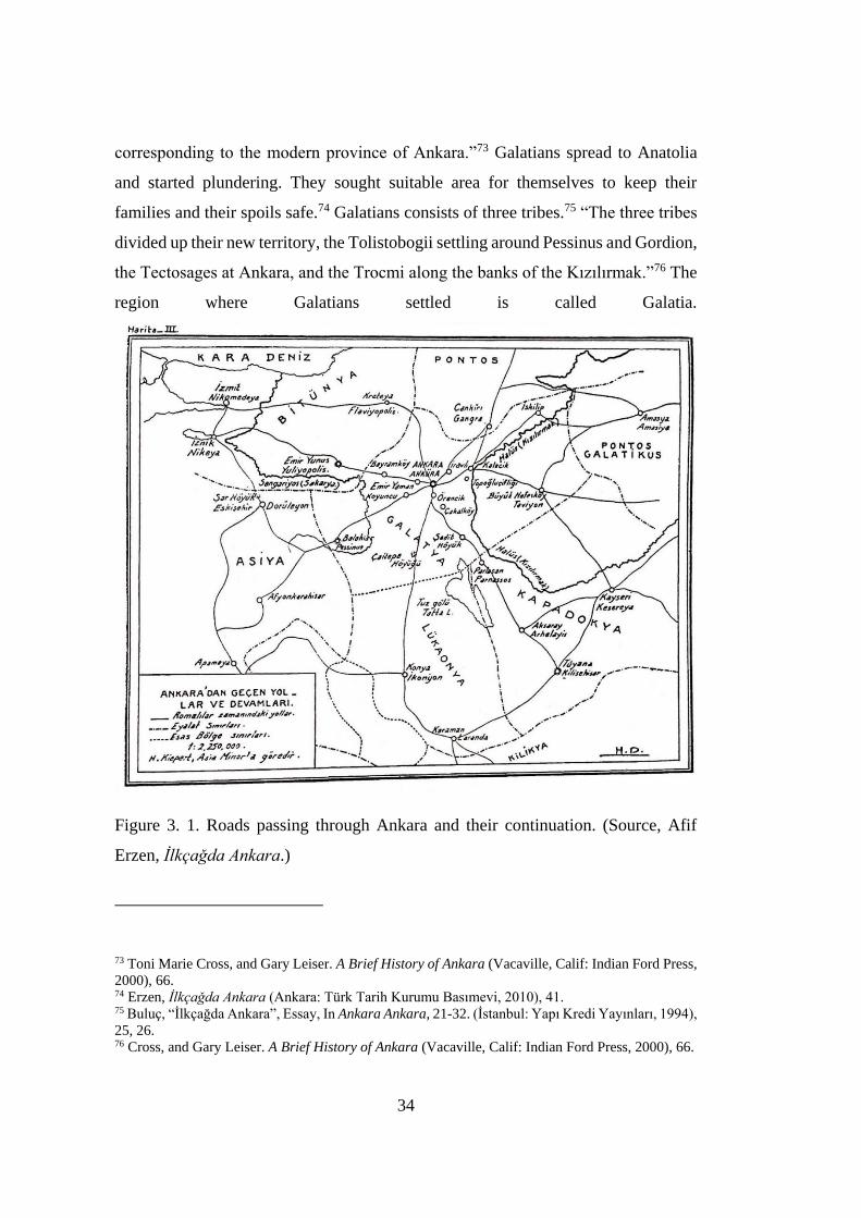
34
corresponding to the modern province of Ankara.”73 Galatians spread to Anatolia
and started plundering. They sought suitable area for themselves to keep their
families and their spoils safe.74 Galatians consists of three tribes.75 “The three tribes
divided up their new territory, the Tolistobogii settling around Pessinus and Gordion,
the Tectosages at Ankara, and the Trocmi along the banks of the Kızılırmak.”76 The
region where Galatians settled is called Galatia.
Figure 3. 1. Roads passing through Ankara and their continuation. (Source, Afif
Erzen, Ilkcagda Ankara.)
73 Toni Marie Cross, and Gary Leiser. A Brief History of Ankara (Vacaville, Calif: Indian Ford Press,
2000), 66. 74 Erzen, Ilkcagda Ankara (Ankara: Türk Tarih Kurumu Basımevi, 2010), 41. 75 Buluç, “İlkçağda Ankara”, Essay, In Ankara Ankara, 21-32. (İstanbul: Yapı Kredi Yayınları, 1994),
25, 26. 76 Cross, and Gary Leiser. A Brief History of Ankara (Vacaville, Calif: Indian Ford Press, 2000), 66.

35
3.1.2 Roman Period and Arrival of Turks to Anatolia
The Romans, who took the Galatia region under their rule as a state, appreciated the
geographical and military importance of Ankara and immediately made this city the
capital city of Galatia.77 After the Romans took Ankara under their rule in 25 BC,
Ankara has become one of the most well-kept cities in the region.78 The settlements
of Galatia, which had rural characteristics rather than a dense urban texture, were
disconnected from each other due to the natural barriers that separated them and the
size of the rural lands. However, the Romans arranged the road system to connect
them with the other cities.79 During the Roman rule, there were many public
buildings built in Ankara. Some of them are: Augustus Temple, Bouleuterion (city
council building), Gymnasion (Palaestra), Theater, Amphitheatre, Hippodrome,
festival place (next to the Augustus Temple), Agora, Columnar Road (between
Augustus Temple and Çankırıkapı), Roman Bath, Zeus Temple, Zeus Taenos
Temple.80
77 Erzen, 52. 78 Suavi Aydın, et al., Kücük Asya'nın Bin Yüzü: Ankara (Ankara: Dost Kitabevi, 2005), 81. 79 Suna Güven, “Bir Roma Eyaletinin Evrim Sürecinde Galatia ve Ancyra”, Essay, In Tarih icinde
Ankara II Aralık 1998 Seminer Bildirileri, 109-122. (Ankara: ODTÜ, 2001), 111. 80 Aktüre, “16. Yüzyıl Öncesi Ankara’sı Üzerine Bilinenler” (Ankara: Orta Doğu Teknik Üniversitesi
Ankaralılar Vakfı, 2000), 7, 8.
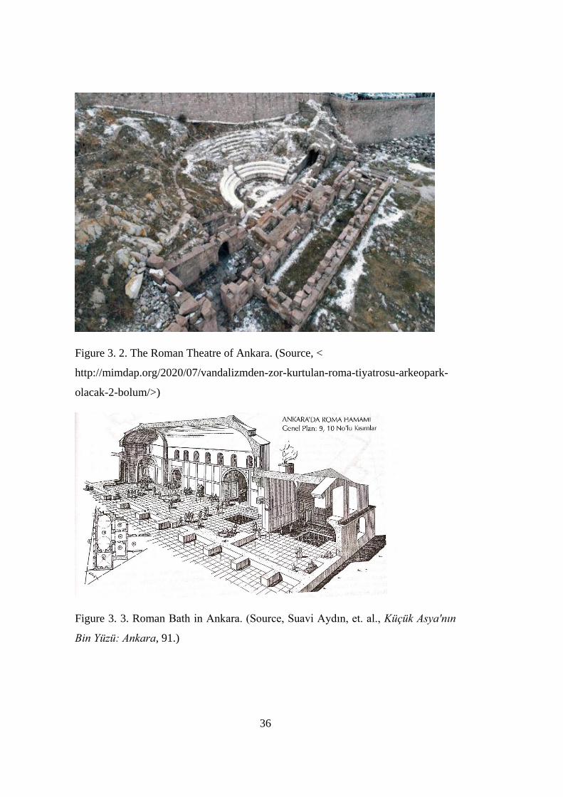
36
Figure 3. 2. The Roman Theatre of Ankara. (Source, <
http://mimdap.org/2020/07/vandalizmden-zor-kurtulan-roma-tiyatrosu-arkeopark-
olacak-2-bolum/>)
Figure 3. 3. Roman Bath in Ankara. (Source, Suavi Aydın, et. al., Kücük Asya'nın
Bin Yüzü: Ankara, 91.)
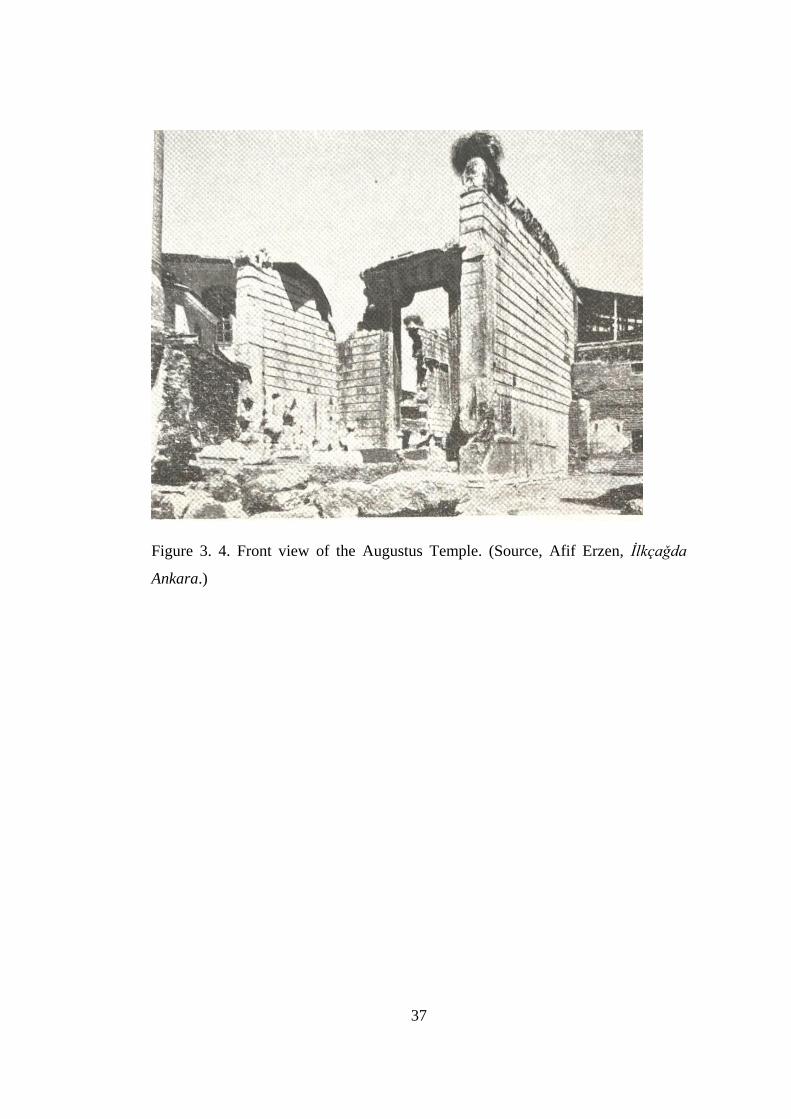
37
Figure 3. 4. Front view of the Augustus Temple. (Source, Afif Erzen, Ilkcagda
Ankara.)
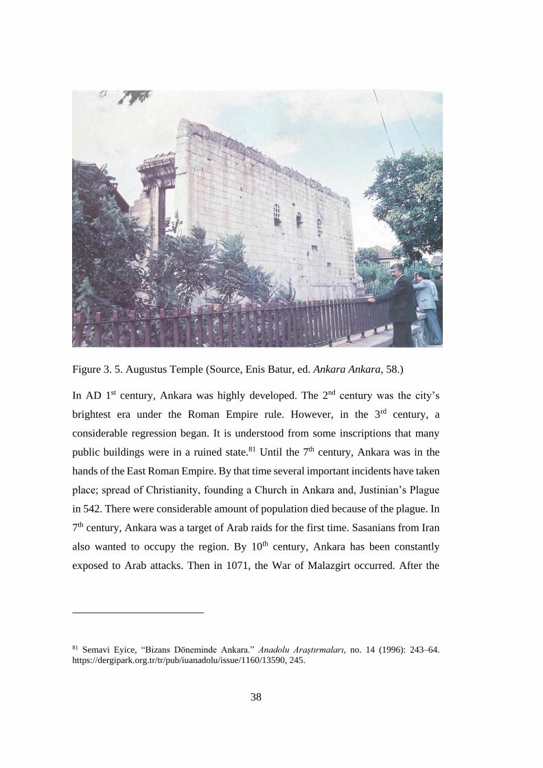
38
Figure 3. 5. Augustus Temple (Source, Enis Batur, ed. Ankara Ankara, 58.)
In AD 1st century, Ankara was highly developed. The 2nd century was the city’s
brightest era under the Roman Empire rule. However, in the 3rd century, a
considerable regression began. It is understood from some inscriptions that many
public buildings were in a ruined state.81 Until the 7th century, Ankara was in the
hands of the East Roman Empire. By that time several important incidents have taken
place; spread of Christianity, founding a Church in Ankara and, Justinian’s Plague
in 542. There were considerable amount of population died because of the plague. In
7th century, Ankara was a target of Arab raids for the first time. Sasanians from Iran
also wanted to occupy the region. By 10th century, Ankara has been constantly
exposed to Arab attacks. Then in 1071, the War of Malazgirt occurred. After the
81 Semavi Eyice, “Bizans Döneminde Ankara.” Anadolu Araştırmaları, no. 14 (1996): 243–64.
https://dergipark.org.tr/tr/pub/iuanadolu/issue/1160/13590, 245.
39
1071 Malazgirt War, the Turkmens came close to Ankara.82 The settlement of Turks
in large groups in Byzantine cities began after 1071. The first settlers to the Anatolian
citites were the soldiers of the Seljuk commanders.83 Turkish dominance was
consolidated in Ankara and this is understood from the fact that the first Turkish
inscriptions began to appear at the end of the 12th century.84
After Anatolia passed under the rule of the Seljuks, there were significant
developments in the east-west transit trade, and a great accumulation of capital was
achieved through this route. In the 12th century, between Istanbul-Konya-Tabriz, a
trade route was operating. Due to transit trade, in the 13th century, cities such as
Konya, Kayseri, and Sivas, located on the main roads, showed a remarkable
development during this period. However, the same growth rate did not occur in
cities such as Ankara that are located on secondary roads. The most evident proof of
this will be revealed by comparing the small and unpretentious religious structures
such as small mosques and masjids built in Ankara whereas many large and
spectacular buildings such as Gök Madrasa, Çifte Minaret, and Buruciye Madrasa
were built in Sivas for example. In the 14th century, Ankara was under the rule of the
Ilkhanians. After Ilkhanians, Ankara was administered by Ahi community.85 The Ahi
community played an important role in Turkification of Anatolia, especially in
Ankara. That is why it is essential to explain this subject briefly.
Ahi organization is a union of tradesmen and craftsmen. Muslim Turks, who came
to Anatolia, did not just bring their political aspects; they also got their culture. When
Seljuk sultans conquered new regions in Anatolia, the first thing they did was to
place tradesmen and artisans there.86 Ahi organization has a versatile social structure.
82 Suavi Aydın, et al., Kücük Asya'nın Bin Yüzü: Ankara (Ankara: Dost Kitabevi, 2005), 106, 118,
119, 120, 122, 128. 83 Aktüre, “16. Yüzyıl Öncesi Ankara’sı Üzerine Bilinenler”, 14. 84 Suavi Aydın, et al., Kücük Asya'nın Bin Yüzü: Ankara, 129. 85 Aktüre, “16. Yüzyıl Öncesi Ankara’sı Üzerine Bilinenler”, 15, 16. 86 Ramazan Karaman, “Türk Ahi Teşkilatının İşleyişi ve Çorum Tarihinde Ahilik.” Hitit Üniversitesi
Sosyal Bilimler Enstitüsü Dergisi 7, no. 1 (June 2014): 95.
40
From the middle of the 13th century, the organization played an important role in
regulating social life of Anatolia.87 In addition to being a formation aiming at social
welfare, it was a kind of training institute based on individual virtue and dedication.
Between the collapse of the Seljuks and the establishment of the Ottoman Empire,
the Ahi organization has great importance in the political life of Anatolian cities.
According to the observations of Ibn Battuta, the Ahi chief becomes the ruler of the
city in regions where the Sultan has no influence. In the period of uncertainty, Konya,
Bayburt, Aksaray, Niğde, Kayseri and Ankara were governed by Ahi order.88 Thus,
with the development and organization of Ahi community in Anatolia, the following
results were obtained89:
1. The transition process of Turks from nomadic life to settled life accelerated.
2. Turkish people started to participate in production and trade activities.
3. Turkish tradesmen and craftsmen have become privileged thanks to the
solidarity between them. They have a voice in the economy of the city.
4. The main rules put by the Ahis formed the basis of the laws and regulations
prepared in this field during the Ottoman period.
In 1363, Sultan Murat I. took Ankara by negotiating with Ahi community without a
battle. The city played an important role as a border city in the process of Ottomans'
conquest of Anatolia. In the period between the end of the 14th century and the end
of the 15th century, many mosques and masjids were built on the slope outside the
Ankara Castle and on the flat area in front of it. The only document that gives the
physical appearance of the city of Ankara in the middle of the 16th century is the
sketch of the city drawn by Dernschwam in 1555. This document shows that Ankara
is a large, open city with no ramparts located on the castle's plain.90 In the 16th and
87 Ali Yılmaz Gunduz, et al., “Ahilik Teşkilatında ve Günümüzde Tüketicilerin Korunkasına Yönelik
Çalışmalar Üzerine bir Değerlendirme.” Afyon Kocatepe Üniversitesi, IIBF Dergisi 14, no. 2 (2012):
38. 88 Suavi Aydın, et al., Kücük Asya'nın Bin Yüzü: Ankara (Ankara: Dost Kitabevi, 2005), 136. 89 Aktüre, “16. Yüzyıl Öncesi Ankara’sı Üzerine Bilinenler”, 18. 90 Aktüre, 20, 21.
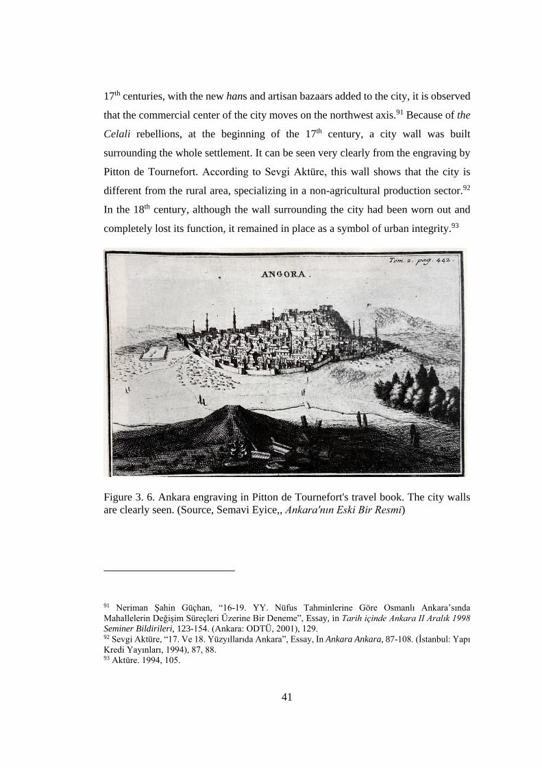
41
17th centuries, with the new hans and artisan bazaars added to the city, it is observed
that the commercial center of the city moves on the northwest axis.91 Because of the
Celali rebellions, at the beginning of the 17th century, a city wall was built
surrounding the whole settlement. It can be seen very clearly from the engraving by
Pitton de Tournefort. According to Sevgi Aktüre, this wall shows that the city is
different from the rural area, specializing in a non-agricultural production sector.92
In the 18th century, although the wall surrounding the city had been worn out and
completely lost its function, it remained in place as a symbol of urban integrity.93
Figure 3. 6. Ankara engraving in Pitton de Tournefort's travel book. The city walls
are clearly seen. (Source, Semavi Eyice,, Ankara'nın Eski Bir Resmi)
91 Neriman Şahin Güçhan, “16-19. YY. Nüfus Tahminlerine Göre Osmanlı Ankara’sında
Mahallelerin Değişim Süreçleri Üzerine Bir Deneme”, Essay, in Tarih icinde Ankara II Aralık 1998
Seminer Bildirileri, 123-154. (Ankara: ODTÜ, 2001), 129. 92 Sevgi Aktüre, “17. Ve 18. Yüzyıllarıda Ankara”, Essay, In Ankara Ankara, 87-108. (İstanbul: Yapı
Kredi Yayınları, 1994), 87, 88. 93 Aktüre. 1994, 105.
42
3.1.3 Economy in Ottoman Times
As stated above, in Ankara, there are craftsmen and tradesmen to a significant extent.
They manufacture all the craft items of that time. All manufacturing is for the local
market, except one. There is a type of fabric called sof, called also as Angora woolen
textiles by the Europeans. This special fabric is made out from tiftik kecisi (Angora
goat). Only sof was manufactured for the global market.94 In 1640, famous traveler
Evliya Çelebi passed through Ankara. He stated that, some French tradesmen wanted
to manufacture the same fabric in France. However, the fabrics they manufactured
did not have the same quality.95 This proved that sof is special to Ankara. Outside
Ankara, the goats could not grow with the same way elsewhere, and consequently,
their feather could not be sufficient. Angora goats, the source of wealth of Ankara,
and their feathers are unique in quality.96 In 1555, traveler Busbecq crossed through
Ankara and he asserted in his letter that even wearing sof is for elites, even Sultan
Suleiman does not want to wear any fabric other than this one.97 Nevertheless, with
the industrialization in Europe in 18th century, manufacturing sof in Ankara has
entered a period of recession.98 The city praised by travelers in the 16th century
turned into a dull city towards the end of 18th century.
94 Mehmet Ali Kılıçbay, “Sof Şehri Ankara”, Essay, In Ankara Ankara, 65-72. (İstanbul: Yapı Kredi
Yayınları, 1994), 67. 95 Kılıçbay, 70. 96 Semavi Eyice, Ankara'nın Eski Bir Resmi tarihi Vesika Olarak Resimler - Ankara'dan Bahseden
Seyyahlar - Eski Bir Ankara Resmi (Ankara: Türk Tarih Kurumu Basımevi, 1972), 75. 97 Aktüre, “16. Yüzyıl Öncesi Ankara’sı Üzerine Bilinenler”, 21. 98 Sevgi Aktüre, “17. Ve 18. Yüzyıllarıda Ankara”, Essay, In Ankara Ankara, 87-108. (İstanbul: Yapı
Kredi Yayınları, 1994), 90.
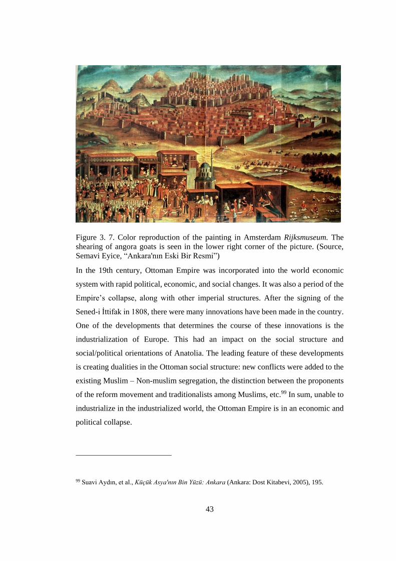
43
Figure 3. 7. Color reproduction of the painting in Amsterdam Rijksmuseum. The
shearing of angora goats is seen in the lower right corner of the picture. (Source,
Semavi Eyice, “Ankara'nın Eski Bir Resmi”)
In the 19th century, Ottoman Empire was incorporated into the world economic
system with rapid political, economic, and social changes. It was also a period of the
Empire’s collapse, along with other imperial structures. After the signing of the
Sened-i İttifak in 1808, there were many innovations have been made in the country.
One of the developments that determines the course of these innovations is the
industrialization of Europe. This had an impact on the social structure and
social/political orientations of Anatolia. The leading feature of these developments
is creating dualities in the Ottoman social structure: new conflicts were added to the
existing Muslim – Non-muslim segregation, the distinction between the proponents
of the reform movement and traditionalists among Muslims, etc.99 In sum, unable to
industrialize in the industrialized world, the Ottoman Empire is in an economic and
political collapse.
99 Suavi Aydın, et al., Kücük Asya'nın Bin Yüzü: Ankara (Ankara: Dost Kitabevi, 2005), 195.
44
The innovations of the period were for westernization. Especially in İstanbul,
outcomes of those westernization attempts were clearly seen. However, in Ankara
and generally in most of the other Anatolian cities, urban spaces did not change
significantly.100 One of the important developments in this century is the arrival of
the railway to Ankara in 1892 December. As a result of this development, the amount
of land opened to agriculture has expanded, agricultural production, prices and
exports increased. With the development of economic conditions, there have been
changes in the population distribution in the internal regions.101 Yet, the arrival of
the railway did not create a substantial change in Ankara's local space
organization,102 except the opening of the İstasyon Avenue and the construction of a
number of public buildings in this direction. In this period, Elmadağ water was
connected to the city at a distance of 20 km in April 1890. The establishment of the
Local Government Organization, the establishment of the Postal Administration, the
creation of the Tulumba Organization are among the other zoning initiatives.103
3.2 The city of Turkish Republic
In the beginning of the 20th century, Ankara was a mid-sized Anatolian town which
was neglected and in disrepair due to the fires and the effects of wars. Aptullah Kuran
describes Ankara as “the city that symbolized the spirited determination of the
Nationalists during the Turkish War of Independence was a small Anatolian town
100 Serim Denel, “19. Yüzyılda Ankara’nın Kentsel Formu ve Konut Dokusundaki Farklılaşmalar
Essay, In Tarih icinde Ankara: Eylül 1981 Seminer Bildirileri,, 129-152. (Ankara: Orta Doğu Teknik
Üniversitesi Ankaralılar Vakfı, 2000), 130. 101 Erdal Yavuz, “19. Yüzyıl Ankarasında Ekonomik Hayatın Örgütlenmesi ve Kent İçi Sosyal Yapı”
Essay, In Tarih icinde Ankara: Eylül 1981 Seminer Bildirileri, 195-206. (Ankara: Orta Doğu Teknik
Üniversitesi Ankaralılar Vakfı, 2000), 201. 102İlber Ortaylı, “19.Yüzyıl Ankara’sına Demiryolunun Gelişi, Hinterlandının ve Hinterlandaki
Üretim Eylemlerinin Değişimi” Essay, In Tarih icinde Ankara: Eylül 1981 Seminer Bildirileri,, 207-
219. (Ankara: Orta Doğu Teknik Üniversitesi Ankaralılar Vakfı, 2000), 215. 103 Mehmet Tuncer, Ankara (Angora) Sehri Merkez Gelisimi (14.-20. Yy) (Ankara: Kultur Bakanligi,
2001), 66.
45
that sprawled at the foothills of a steep citadel crowned by a study fortress.”104 After
the collapse of the Ottoman Empire, the country was occupied and Ankara became
the headquarters of the War of Independence. National Assembly was held for the
first time in Ankara on 23rd of April, 1920. And the Republic was proclaimed in
1923. Due to geographical reasons and politically being distant from outside forces
and since “Mustafa Kemal was sure that he would find the necessary social support
for this new formation in Ankara, depending on the immense cooperation of the city
during the Independence War,” Ankara was proclaimed as a new capital of the new
Republic.105 Chosen as a capital, the economy and physical qualities of Ankara began
to change. It was populated by new comers to the city. There was a fast acceleration
of urban development. The city was pioneered to be the first planned city of the
Republic.
This new political regime established a homogeneous Turkish identity against the
heterogeneous structure of the Ottoman Empire and tried to redefine its past and its
future within the framework of this homogeneous social identity. The new regime
also planned to make innovations in social, political and economic context. We call
these radical changes in the framework of social, political and economic life as a
modernization project.106 This modernization project helped to reconstruct the
collective identity of the new country. The new city will represent the desire and
ideals of the young nation. At the same time, it will be the place of a new way of
administration and a new way of life.
Ankara underwent many critical governmental and social transformations. Building
a city from its ashes has physical, social, cultural, and economic difficulties. This
104 Aptullah Kuran, Selcuklular'dan Cumhuriyet'e Türkiye'de Mimarlık (İstanbul: Türkiye İş Bankası,
2012), 671. 105 Elif Mıhçıoğlu, “The Physical Evolution of The Historic City of Ankara Between 1839 and 1944:
A Morphological Analysis” (PhD Thesis, Middle East Technical University, 2010), 181, 182. 106 İnci Yalım, “Ulusal Devletin Kamusal Alanda Meşruiyet Aracı: Toplumsal Belleğin Ulus Meydanı
Üzerinden Kurgulanma Çabası”, Essay, in Başkent Üzerine Mekân-Politik Tezler, Ankara’nın
Kamusal Yüzleri, ed. Güven Arif Sargın, 157-214. (İstanbul: İletişim Yayıncılık, 2002), 167.
46
section of the thesis will explain the physical and socio-cultural consequences of the
decisions on Ankara town planning. Before analyzing the socio-cultural dimensions
of the new capital, the urban agreements and developments will be explored.
3.2.1 Urban Development of Ankara
Decline of the Ottoman Empire resulted in many consequences. One of the
consequences was to find a new center for ruling the country. Aptullah Kuran made
a comparison between İstanbul and Ankara stressing the situations of Fatih Sultan
Mehmet and Mustafa Kemal Pasha. He stated that after conquering İstanbul, the
Conqueror declared the city as a capital because at those times it was a rational
decision because of the location and strategic choices. However, the situation was
not suitable to Mustafa Kemal Pasha. As Aptullah Kuran stated, “İstanbul was no
longer the glorious metropolis that it had once been. It symbolized decadent
cosmopolitanism, which the Nationalists found incompatible with the spirit of the
new Turkey.”107 Ankara was the headquarter of the War of Independence and the
place where the National Assembly was met. This is the main reason why it was
designated as the capital city of the newly founded Republic of Turkey. Its being
located at the center of the country was another reason of its selection. “Ankara’s
close proximity to water and coal resources, extensive land conducive for a new city
establishment, and connection to all the regions of the country by railway” were
some of the decisive factors behind selecting the city as a capital.108 Gazi Mustafa
Kemal made comments on the issue of selecting Ankara as a capital with editors of
influential newspapers on January 16th, 1923. He stated:
107 Aptullah Kuran, Selcuklular'dan Cumhuriyet'e Türkiye'de Mimarlık (İstanbul: Türkiye İş Bankası,
2012), 672. 108 Nevruz Cinar Ozdil, et al., “Emergence and Evolution of the Urban Public Open Spaces of Ankara
within the Urban Development History: 1923 to Present.” Journal of Planning History 19, no. 1
(February 2020): 26–51. https://doi.org/10.1177/1538513219848434. 28.
47
“According to my thinking, the question of the seat of government must be
viewed from two perspectives. First of all, the seat of government must be a
place to withstand any type of military offensive. Therefore one naturally
considers the central regions of the country. … Secondly, it must be so
situated that the government can see all parts of the country with equal clarity.
When we retire to a corner, we tend to forget those parts of the motherland
that are farthest from us.”109
As explained previously, Ankara was not a well-kept city in Anatolia. The city had
a lack of suitable facilities. The emptiness of the city was also one of the reasons to
choose. Because it will be easily built as requested. “Ankara’s built environment
provides a fertile ground for examining the untidy process by which republican ideals
of a modern urban life and a new political culture were translated into action.”110
Gönül Tankut posits in her book Bir Başkentin Imarı that capital cities are being built
to symbolize the world-views of country leaders.111 Decisions for the city's zoning
will be an indicator of a strong power. The urban planning strategies had to be
successful because the image of the city is an outcome of Turkish modernization and
hence the young Turkish Republic. That is why constructing a new city itself is above
all a political claim.112
Achieving successful urban planning was vital for other Anatolian cities. Ankara was
a candidate to be a model for the rest of the country. Zeynep Kezer argues: “Indeed
the founding fathers of the republic considered building a new capital in Ankara to
be integral to their twin goals of modernizing the country and forging a new political
109 Kuran, 675. 110 Zeynep Kezer. Building Modern Turkey : State, Space, and Ideology in the Early Republic. Culture
Politics & the Built Environment. Pittsburgh (Pa: University of Pittsburgh Press, 2015), 19. 111 Gönül Tankut, Bir Başkentin Imarı: Ankara: 1929-1939 (Cağaloğlu, İstanbul: Anahtar Kitablar,
1993), 15. 112 Bülent Batuman, “Mekan, Kimlik ve Sosyal Çatışma: Cumhuriyet’in Kamusal Mekanı Olarak
Kızılay Meydanı”, Essay, in Başkent Üzerine Mekân-Politik Tezler, Ankara’nın Kamusal Yüzleri, ed.
Güven Arif Sargın, 41-76. (İstanbul: İletişim Yayıncılık, 2002), 42.
48
order.”113 The expectation from the modern Ankara is not only representative, it is
to be a capital that can fulfill the understanding of the new worldview and reflect the
lifestyle that suits it. “In the modern town planning approach, modern cities are
functionally segregated in different parts designated for such purposes as production,
residential areas, commercial uses, and public spaces.”114 The aim was the same for
Ankara. To do this, a number of urban planning projects were developed for Ankara.
After explaining those town planning strategies, it will be discussed whether the city
succeeded in that aim or not.
3.2.1.1 The Lörcher Plan
With the proclamation of the Republic, considerable number of people moved to
Ankara. Even before the declaration of the city as capital, soldiers, generals and
government officials started to come to Ankara. This situation increased the need for
housing and governmental buildings. For this reason, zoning work had to be started
immediately. “Between 1923 and 1927 Ankara grew somewhat haphazardly. This
was primarily the result of the pressing need for the construction of basic government
facilities.”115 There was obviously a need for institutional change in Ankara in order
to speed up the growth of the city. Therefore, Ankara Şehremaneti was established
in 1924 as the first municipality organizational initiative and the Expropriation Act,
which was put into action in 1925 to expropriate 400 hectares, were the two major
leaps for the city’s development.116 In the first years, there were not a coordinated
planning. The new settlement areas were mostly located on the empty plots of the
old city or on the outer edges of the old city.117 However, rapid population growth
has revealed the necessity of a major city planning. For a planned urban
113 Zeynep Kezer. Building Modern Turkey : State, Space, and Ideology in the Early Republic, 17. 114 Nevruz Cinar Ozdil, et al., “Emergence and Evolution of the Urban Public Open Spaces of Ankara
within the Urban Development History: 1923 to Present.” 27. 115 Cross, and Gary Leiser. A Brief History of Ankara (Vacaville, Calif: Indian Ford Press, 2000), 144. 116 Nevruz Cinar Ozdil, et al., 28. 117 Gönül Tankut, Bir Başkentin Imarı: Ankara: 1929-1939, 44.
49
development, there was a need for an urban planner. “Due to the absence of
professionals in the urban planning field, European architects and urban planners
were invited for the urban planning of the city.”118 Ankara Şehremaneti requested a
plan for Ankara from İstanbul based private construction company.119 Carl Christoph
Lörcher who was a German architect, became the first planner of Ankara. The first
plan was Lörcher’s urban development plan which was designed in 1924.
With Lörcher's urban plan, it was aimed to establish a modern and planned capital
for Turkey. Lörcher thought that the old city has its own powerful grounds, the new
city should be founded around the old city. He developed three plans: one was for
old city but it was not approved, the second one was for the new city and the last one
was a combined plan for both new and old city. The last two plans were approved.
The reason why the commission rejected the first plan for the old city is that the plan
was because it was found inapplicable. Trying to expand the old town created
bureaucratic and economic difficulties. The establishment of the new city will make
it easier to achieve its integrity through an easier and healthier process, while the old
texture will not be damaged.120 The rest of the plans were compulsorily accepted
because of the housing crisis.121
118 Nevruz Cinar Ozdil, et al., 28. 119 Ali Cengizkan, Ankara’nın Ilk Planı 1924-25 Lörcher Planı,(Ankara: Ankara Enstitüsü Vakfı,
2004), 35. 120 Cengizkan, 57. 121 Tankut, Bir Başkentin Imarı: Ankara: 1929-1939, 54.
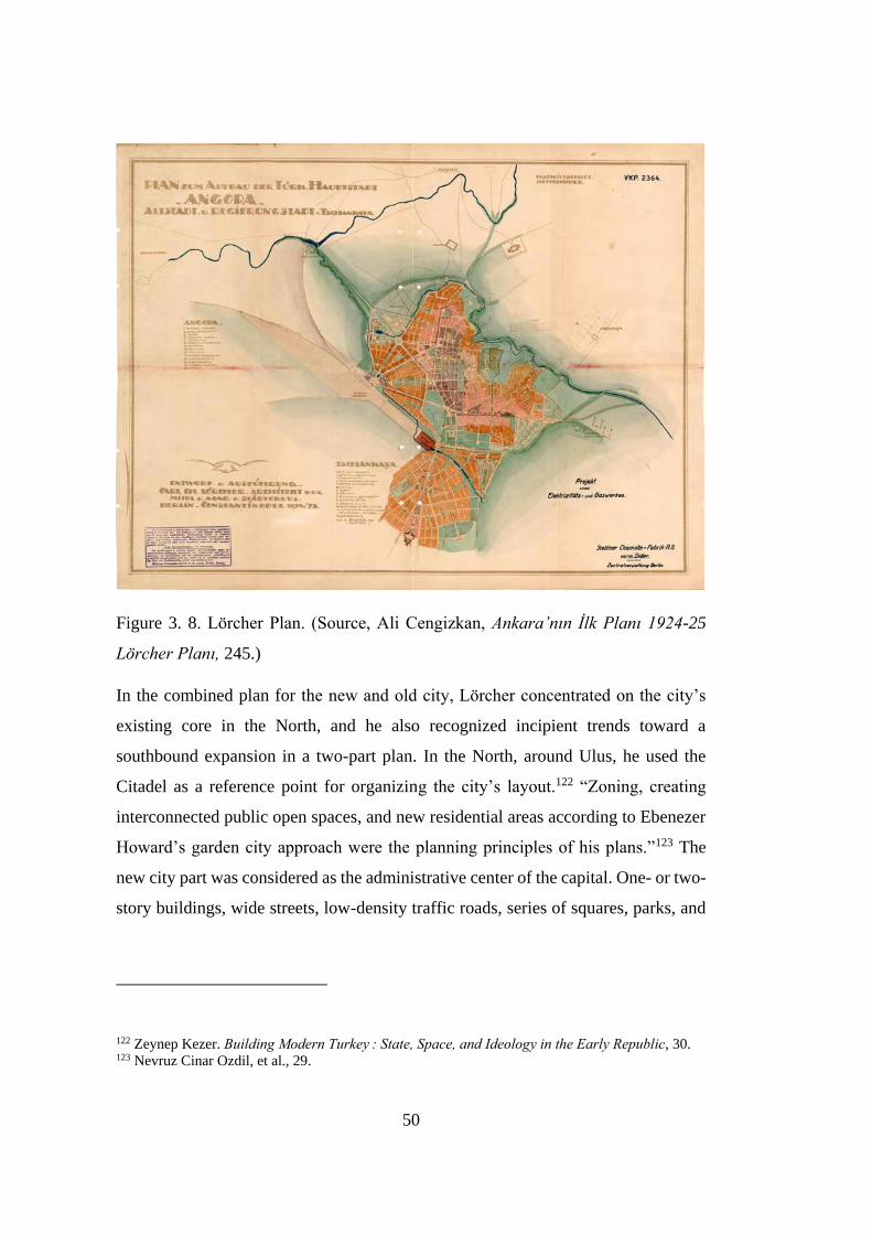
50
Figure 3. 8. Lörcher Plan. (Source, Ali Cengizkan, Ankara’nın Ilk Planı 1924-25
Lörcher Planı, 245.)
In the combined plan for the new and old city, Lörcher concentrated on the city’s
existing core in the North, and he also recognized incipient trends toward a
southbound expansion in a two-part plan. In the North, around Ulus, he used the
Citadel as a reference point for organizing the city’s layout.122 “Zoning, creating
interconnected public open spaces, and new residential areas according to Ebenezer
Howard’s garden city approach were the planning principles of his plans.”123 The
new city part was considered as the administrative center of the capital. One- or two-
story buildings, wide streets, low-density traffic roads, series of squares, parks, and
122 Zeynep Kezer. Building Modern Turkey : State, Space, and Ideology in the Early Republic, 30. 123 Nevruz Cinar Ozdil, et al., 29.
51
greenways were proposed in the 1925 new city plan.124 Lörcher placed a systematic
emphasis on green space planning. What he proposed was trying to connect green
spaces in old and new cities. “In addition to the open green spaces, several public
squares named Millet (today’s Ulus Square); Hukumet, Tiyatro, Gazi, Yildiz,
Istasyon, Haci Bayram, and Kale (Citadel) in the old city; and Cumhuriyet (today’s
15 Temmuz Kizilay Milli İrade Square), Sihhiye, Zafer, Lozan, squares in the new
city part were proposed in the Lörcher Plan.”125 He also designed radial boulevards
and some of them were built. New administrative buildings (the new National
Assembly Building, the Ministry of Foreign Affairs), banks (Ziraat Bankası, İş
Bankası, Osmanlı Bankası), residential structures (Evkaf Apartments), cultural
institutions (Ethnography Museum, Turkish Hearths Association), and recreational
facilities (Ankara Palas, Millet Bahçesi) were positioned according to his precepts.126
It is seen that an axial design is dominant in Lörcher's plan. Apart from the main
Atatürk Boulevard, there were many axes connected to this main road. Ali Cengizkan
commented on the design of Lörcher as:
“It is seen that new roads are made with triangulation technique. As a result
of this approach, which is the product of a Baroque understanding, it is seen
that all of the old Ankara and a certain part of the New City were formed
within these large-scale triangular urban blocks. It is observed that this
understanding has been changed with later contemporary practices,
sometimes by preserving the squares proposed by the Lörcher Plan and
connecting them with new 'parallel roads', and sometimes by newly opened
roads within the texture.”127
124 Ibid., 29. 125 Ibid., 29. 126 Zeynep Kezer, 32. 127 Ali Cengizkan, Ankara’nın Ilk Planı 1924-25 Lörcher Planı,(Ankara: Ankara Enstitüsü Vakfı,
2004), 59.
52
This triangulation technique has produced many strong axes. Strong perspectives
emerged along these axes. Ankara Castle is a significant element that Lörcher wanted
to emphasize through these perspectives. In the article he published at the beginning
of 1925, Lörcher defines the Citadel of Ankara as follows: “The idea of viewing the
very beautiful Castle (Zitadelle) whenever possible and attracting the city here is
often repeated… Lörcher says, “The desire to include the elegant (beautiful) Castle
in the city's panorama from as many viewpoints as possible has been fulfilled
elsewhere.”128 Lörcher emphasized that the visual references to the Castle were
frequently used in urban planning. Ali Cengizkan continues about the notion of
beautiful Castle:
“This approach, which would crystallize as the concept of "Crown of the
City" in Jansen's 1928 Competition Plan, first appeared in the Lörcher Plan
and was put into practice in the Ulus district. Establishment of Istasyon Street
and Cumhuriyet Street; The visual relationship of Opera with the Citadel; the
visual relationship of the “Millet Bahcesi” with Hacı Bayram and the Temple
of Augustus; relationship of Ulus Square with Kale; considering Hacet
Tepesi as a sub-focus were the contribution of the Lörcher Plan and they were
both preserved and improved in the 1932 Jansen Plan.”129
All these perspective relations reveal the significance of the axes and their visual
connection with the Castle of Ankara. The main axis determined by Lörcher has the
parliament building at one end and the Castle at the other end. This situation shows
that Lörcher emphasizes monumentality together with axiality. Parliament building
is the most imposing building as a monumental structure in the city and the Castle is
another remarkable structure. By placing a monumental parliament building on the
other end of the main axis, on which the castle is at one end, he may have actually
128 Cengizkan, 85. 129 Ibid., 85.
53
aimed to symbolize the authority of the newly established state the sovereignty of
the Nation, on which the new Republic was founded.
Along the main axis, other important public buildings, banks, cultural institutions
such as museums and squares were placed as mentioned above. “The power of the
axis directly depends on the connection established between the two points and
supporting elements along it.”130 Each of the squares along the axis as supporting
element was allocated for special events. For example, Hakimiyet-i Milliye and
Zafer Squares represent the national sovereignty and the victory of Turkish people
in the War of Independence.
Carl Christoph Lörcher’s Ankara development plan for influenced all the planners
who came after him, both as a result of being the center of the region he designed
and his right decisions. Nevertheless, Lörcher’s development plan was only partially
achieved. The effects of the declaration of Ankara as the capital on urbanization
could not be taken into account. There were problems arising from the rapid
population growth within a short time following the declaration of capital. The
planned capital of a newly formed state was expected to be thorough. This
perfectionism wanted by the newly established capital did not tolerate the plan's
inadequacy. All these reasons caused an unfinished plan. After all, with Lörcher’s
plan, part of the new city was outlined. The north-south and east-west axes, which
are the main road connections, have also been finalized.131
3.2.1.2 The Jansen Plan
To control uncoordinated developments, raising urban problems, and respond to
growing complaints, in 1927, the government organized an international
130 Özgür Dinçer, “Axiality In The Process Of Space Organization In Architecture” (M.Sc. diss., İzmir
Institute of Technology, 1999), 18. 131 Tankut, Bir Başkentin Imarı: Ankara: 1929-1939, 65, 66.
54
competition. Three renowned city planners from Germany and France were invited
to prepare their plans for the future development of the capital city. German architect
Herman Jansen’s urban development plan was selected among others, as his plan
was found as being the most applicable one for the development of the new capital,
as well as being the most appropriate to the national character. Jansen's difference
from others in attitude is that he can propose modest solutions and put forward
concrete thoughts by getting inside information.132 The Jansen Plan was approved
by a decision of the Council of Ministers on 23 July 1932.133 The plan proposed a
simple zoning for the capital Ankara and was carried out the urban development that
was started according to the 1924-25 Lörcher Plan. In this framework of zoning, he
defined urban zones such as Larger Houses Zone, Amele (Workers’) Quarter, High
Schools (Universities) Area, Tandoğan Airport Area.134 The plan proposed Ulus as
the city center and the preservation of the traditional urban fabric around the Citadel
with a few enhancements.135 Most of his proposals were implemented. Some of them
were as follows:
Connecting the old city to Çankaya, Atatürk Boulevard has been expanded
and opened in the north-south direction as the city's most important artery.
He defined Talatpaşa Boulevard in the east-west direction. These two main
arteries are planned to cross the city.
The low-altitude lands between the old city and the Station are reserved for
sports and recreation uses with open areas such as Youth Park, 19 Mayıs
Sports Site, Hippodrome, Cebeci Stadium.
132 Tankut, 74. 133 Suavi Aydın, et al., Kücük Asya'nın Bin Yüzü: Ankara (Ankara: Dost Kitabevi, 2005), 392. 134 Ali Cengizkan, “Türkiye Için Modern Ve Planlı Bir Başkent Kurmak: Ankara 1920-1950.”
goethe.de. Accessed March 13, 2021. https://www.goethe.de/ins/tr/ank/prj/urs/geb/sta/trindex.htm. 135 Nevruz Cinar Ozdil, et al., 31.
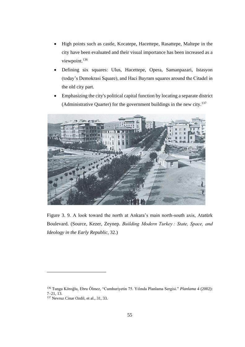
55
High points such as castle, Kocatepe, Hacettepe, Rasattepe, Maltepe in the
city have been evaluated and their visual importance has been increased as a
viewpoint.136
Defining six squares: Ulus, Hacettepe, Opera, Samanpazari, Istasyon
(today’s Demokrasi Square), and Haci Bayram squares around the Citadel in
the old city part.
Emphasizing the city's political capital function by locating a separate district
(Administrative Quarter) for the government buildings in the new city.137
Figure 3. 9. A look toward the north at Ankara’s main north-south axis, Atatürk
Boulevard. (Source, Kezer, Zeynep. Building Modern Turkey : State, Space, and
Ideology in the Early Republic, 32.)
136 Tunga Köroğlu, Ebru Ölmez, “Cumhuriyetin 75. Yılında Planlama Sergisi.” Planlama 4 (2002):
7–21, 13. 137 Nevruz Cinar Ozdil, et al., 31, 33.
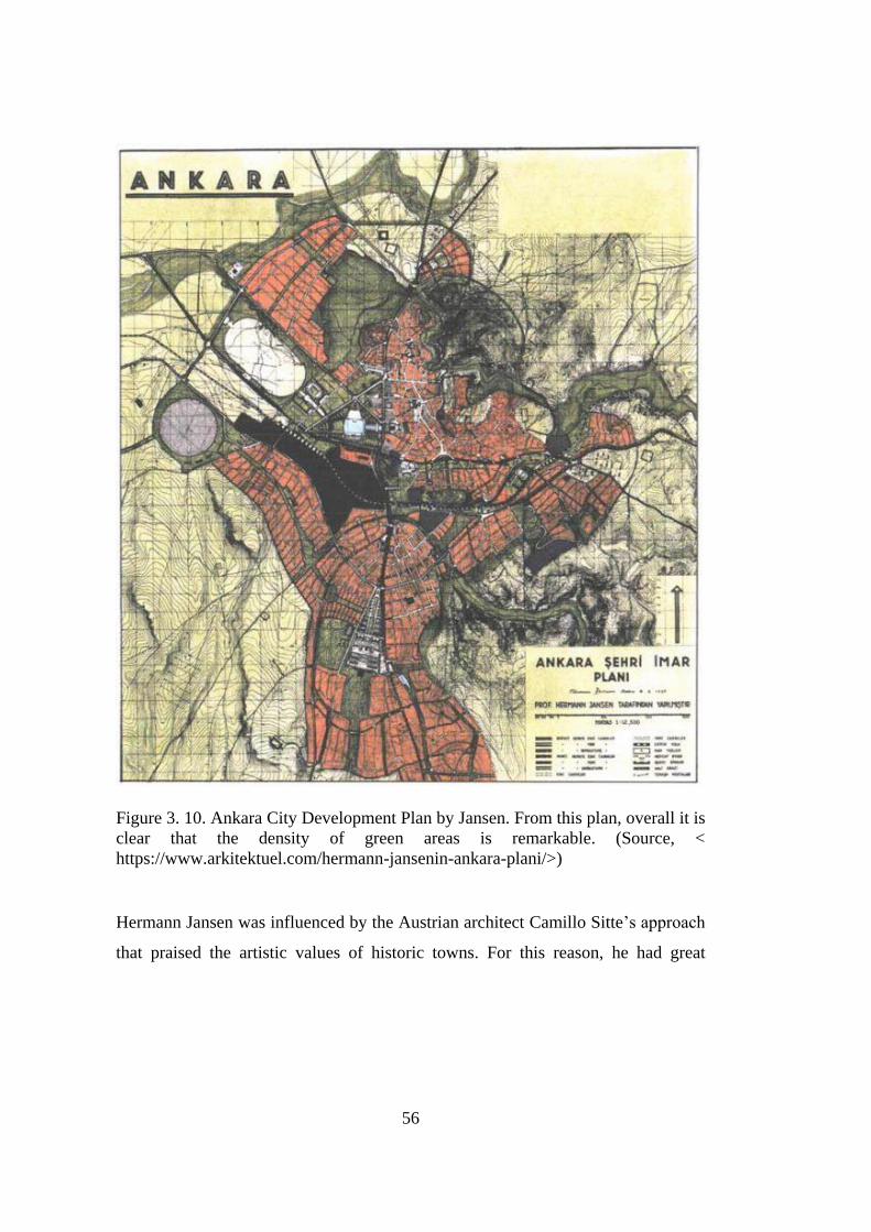
56
Figure 3. 10. Ankara City Development Plan by Jansen. From this plan, overall it is
clear that the density of green areas is remarkable. (Source, <
https://www.arkitektuel.com/hermann-jansenin-ankara-plani/>)
Hermann Jansen was influenced by the Austrian architect Camillo Sitte’s approach
that praised the artistic values of historic towns. For this reason, he had great
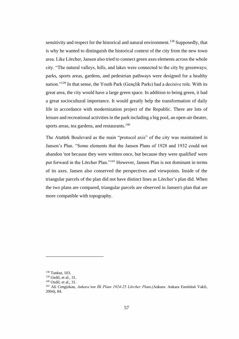
57
sensitivity and respect for the historical and natural environment.138 Supposedly, that
is why he wanted to distinguish the historical context of the city from the new town
area. Like Lörcher, Jansen also tried to connect green axes elements across the whole
city. “The natural valleys, hills, and lakes were connected to the city by greenways;
parks, sports areas, gardens, and pedestrian pathways were designed for a healthy
nation.”139 In that sense, the Youth Park (Gençlik Parkı) had a decisive role. With its
great area, the city would have a large green space. In addition to being green, it had
a great sociocultural importance. It would greatly help the transformation of daily
life in accordance with modernization project of the Republic. There are lots of
leisure and recreational activities in the park including a big pool, an open-air theater,
sports areas, tea gardens, and restaurants.140
The Atatürk Boulevard as the main “protocol axis” of the city was maintained in
Jansen’s Plan. “Some elements that the Jansen Plans of 1928 and 1932 could not
abandon 'not because they were written once, but because they were qualified' were
put forward in the Lörcher Plan.”141 However, Jansen Plan is not dominant in terms
of its axes. Jansen also conserved the perspectives and viewpoints. Inside of the
triangular parcels of the plan did not have distinct lines as Lörcher’s plan did. When
the two plans are compared, triangular parcels are observed in Jansen's plan that are
more compatible with topography.
138 Tankut, 103. 139 Ozdil, et al., 31. 140 Ozdil, et al., 31. 141 Ali Cengizkan, Ankara’nın Ilk Planı 1924-25 Lörcher Planı,(Ankara: Ankara Enstitüsü Vakfı,
2004), 84.
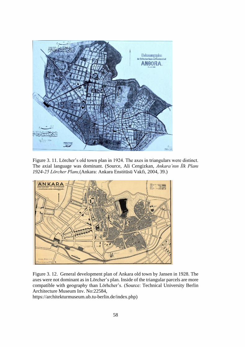
58
Figure 3. 11. Lörcher’s old town plan in 1924. The axes in triangulars were distinct.
The axial language was dominant. (Source, Ali Cengizkan, Ankara’nın Ilk Planı
1924-25 Lörcher Planı,(Ankara: Ankara Enstitüsü Vakfı, 2004, 39.)
Figure 3. 12. General development plan of Ankara old town by Jansen in 1928. The
axes were not dominant as in Lörcher’s plan. Inside of the triangular parcels are more
compatible with geography than Lörhcher’s. (Source: Technical University Berlin
Architecture Museum Inv. No:22584,
https://architekturmuseum.ub.tu-berlin.de/index.php)

59
3.2.1.3 Uybadin-Yucel Plan and Its Aftermath
After the Second World War, there have been changes that led to the acceleration of
urbanization in the world. Turkey was also affected by this situation and big cities
started to be exposed to intense immigration. With this immigration phenomenon in
Ankara, the city was subject to a rapid population increase. Jansen Plan envisages
the population up to 300.000 in 1980. However, due to the continuing population
growth, the city’s population exceeded this number in 1950.142 This caused more
need for housing and urban services. There were started to appear squatter
developments in the periphery of the city. Because of such problems as stated by
Özdil et al.;
“Jansen’s responsibility as the consultant was terminated by the Planning
Administration Committee at the end of 1938 on the grounds that there was
no need of his consultancy anymore. The city developed according to the
decisions of the Planning Administration Committee until the next urban
development plan competition.”143
Despite the problems that it encountered, this plan is stated to be the first urban plan
that was implemented to a great extent. Much of proposed green public spaces were
implemented and added to the city. The protection of the old city area was
accomplished and a connection between the old and the new city was successfully
attained. General opinion of the public towards the plan was positive.
Irregular squatter developments in the periphery, housing problems and continuing
migration from small cities forced zoning management to a new competition for a
142 Tunga Köroğlu, Ebru Ölmez,, 15. 143 Ozdil, et al., 34.

60
new urban development plan. The second development plan competition, held in
1957, was also an international competition. “The winners of the competition were
Nihat Yucel and Rasit Uybadin, architects whose plan proposal was approved in
1957. The population projection of the plan was 750,000 in 1987.”144 According to
Gönül Tankut, this time, nevertheless, it is an unconscious effort seeking a solution
in a crisis situation. The second Ankara zoning plan does not have a broad
perspective that will bring a solution to a rapidly growing city. And she continues,
for this reason, it did not go beyond legalizing old mistakes.145
According to Yücel-Uybadin development plan: Kızılay was determined as a new
city center. Meanwhile, Ulus district still developed its commercial activities.146
Özdil et al. states;
“The 19 May Sport Complex, Ataturk Forest Farm, Hippodrome, Cebeci
Stadium, Guvenpark, Hacettepe Park, Genclik Park, Kurtulus Park, and Zafer
Square-Parks were some of the public open spaces that were created in the
Jansen Plan and kept in the Uybadin–Yucel Plan.”147
Lörcher and Jansen gave an intense importance to green spaces and greenways for
leisure and recreational activities. Atatürk Boulevard was also designed both as a
main artery of the city and a promenade for people to walk and spend time in green.
In Yücel-Uybadin plan, the boulevard began to lose its character. Because the
buildings on the boulevard increased by up to ten to thirteen stories in height as a
result of the density increase law.148
The plan was in operation between 1958 and 1968. It played a major role in the
formation of the current urban pattern of the central city of Ankara today. The high-
144 Ibid., 36. 145 Tankut, 18. 146 Mehmet Tunçer, “Ankara’da Tarihsel Çevrenin Korunmasına Yönelik Politikalar”, Essay, In Tarih
icinde Ankara II Aralık 1998 Seminer Bildirileri, 75-107. (Ankara: ODTÜ, 2001), 76. 147 Ozdil, et al., 37. 148 Ibid., 37.
61
rise apartment development and the increased industrial uses in particular parts of
the city are some of the implications of this plan. Like the previous development
plans, the population projection was exceeded in 1965, instead of 1987.149 The
Yücel-Uybadin urban planning, which does not predict social forces well, has
created a dual structure, with regular apartment blocks on the one hand and squatters
on the other. Eventually, as Gönül Tankut posits, this plan also did not bring great
solutions either. “Subsequently, the Ankara Metropolitan Area Master Plan Bureau
was established in 1969 by the National Security Council. The Bureau initiated the
first planning practice on a metropolitan scale in the country.”150 There was no
competition for the third plan prepared for Ankara. Besides, Ankara has reached the
metropolitan scale. With this reason, the master development plan, which was
produced in 1975 and aimed for the year of 1995, is a master plan that aimed to solve
the problems of the big city at a metropolitan scale.151
3.3 Social and Spatial Transformation and Collective Memory
Social change brings a new identity with it and this change substantiates through
redefining the relation between the past and present. Collective memory is the
foundation of such social change. The production of space is a fundamental practice
in the production of collective memory, because societies perceive the space they
produce as their images. In that sense, space production is also prominent in social
change. In this part, the modernization of Ankara and the creation of new public
spaces defined according to the new regime will be examined. In addition, the effects
of new decisions in the city on social change and collective memory will be
discussed.
149 Ibid., 38. 150 Ibid., 38. 151 Gönül Tankut, Bir Başkentin Imarı: Ankara: 1929-1939, 18.
62
In the previous chapter, the theoretical framework of collective memory is explored
in detail. It is asserted that the collective memory is highly dependent on the social
framework and it also has spatial attributes as well as temporal ones. It is possible to
argue that collective memory is the collection of impressions of the social and spatial
changes that take place in the city over time on the inhabitants. These impressions
are an important legacy of the city, which is transmitted as a record from generation
to generation, mostly verbally. In the case of Ankara, exactly what happened was
social and spatial changes to constitute new collective memory in the name of
nationalism. Or the formation of a new collective memory and social identity
established a radical change in the society and directed spatial configuration in the
city. Güven Arif Sargın argues, “As the images of this period clearly depict,
constructing a new bourgeois identity as well as making an official memory through
the forces of spatial transformation were the constituent elements of the nationalist
policies and perspectives.”152 Upon this reciprocal process, with well-defined
institutions and shared beliefs and values, social change will occur.
As the capital of the young republic, Ankara was determined to leave the existing
Ottoman social and spatial structure by establishing a new city behind. What was
intended by leaving Istanbul and making Ankara the capital: to establish a new and
exemplary city where modern, contemporary, western life can be born, to develop
the life patterns of the national bourgeoisie to be created by the republic to set an
example for other Turkish cities, to symbolize the achievements of the republic in
the birth of this modern city.153 Building a modern capital from scratch could only
be achieved by republican intelligence and dedication. This was what happened at
the beginning of the republican period. “What could be considered as old, traditional,
152 Güven Arif Sargın, “Displaced Memories, or the Architecture of Forgetting and
Remembrance.” Environment and Planning D: Society and Space 22, no. 5 (October 2004): 659–80,
661. 153 İlhan Tekeli, “Ankara’nın Başkentlik Kararının Ülkesel Mekan Organizasyonu ve Toplumsal
Yapıya Etkileri Bakımından Genel Bir Değerlendirilmesi” Essay, In Tarih içinde Ankara: Eylül 1981
Seminer Bildirileri,, 317-335. (Ankara: Orta Doğu Teknik Üniversitesi Ankaralılar Vakfı, 2000), 321.
63
or stagnant was then abandoned and excluded from the republican imaginations: for
the state elite as well as the new bourgeois, the emerging nation's memory was finally
a tabula rasa.”154
3.3.1 Space Production of the Nation-State
To enter a new phase of modernization and abandon the old traditional order, it is
necessary to define a new relationship of the society with the past and the future. For
the new national identity, it was almost a must to stand against the past. Changing
spatial practices and bringing new ones were one of the actions of opposition to the
past. Space production is a fundamental action in the production of collective
memory. Societies perceive the space they produce as their own images. Therefore,
space production is an important issue in the organization of the new order, and
Ankara, the image of the nation-state, is a platform where the new order will realize
itself.
As a space production, public arenas are natural parts or reflections of urban life and
culture. In the case of Ankara, remembering through public spaces had an immense
role in creating collective memory. The act of remembering is also critical to
perceive the ideological content of the public sphere through concrete forms. There
was a remembering technique in ancient Greek. In principle, the system was based
on determining related images for information to be kept in mind with a particular
layout. Orators used the architectural medium and images to memorize their speech.
What was discovered here was the importance of order and perception of vision in
the act of remembering memory. It was the architectural setup that provided the
order. The visual perception was provided by images. This effect of spatial construct
on memory has enabled us to look at the political aspect of the public sphere from a
new perspective. And, the produced space will begin to be perceived as the
154 Güven Arif Sargın, 661.
64
domination that political images try to establish on memory.155 In that sense, memory
is not just a storage of experiences, it is a system that affected by particular layouts
and images for the sake of recalling. As stated in the theoretical chapter,
remembering happens in the light of the present because today’s environment has
effects on the act of perceiving. The modified perception does not recall the exact
past, it recalls an image from the eyes of the present that remained in our memory.
According to this remembering process, recalling is actually a powerful tool for
reproducing the social perception system. If the representation of reality changes
constantly, then the common social thought could be changed depending on the
altered reality. As the social context changes, the past must also be reconstructed to
affirm it. Remembering is actually a reconstruction process of the past. Society
establishes a different relationship with the past according to the context in each
period. And, it creates a different social memory by reconstructing the elements to
be remembered and forgotten. Turning points help to determine the elements whether
to be remembered or forgotten. Another point in the remembering process is the
placement of memories systematized by milestones in concrete spaces. After a while,
turning points begin to be remembered by being represented in a single event or
personality.156 In the case of Ankara, the single event to be remembered was the War
of Independence and the most important actor of that single event was Mustafa
Kemal Atatürk. This turning point helped to construct the collective memory that
belonged to the Nation.
Turkey (as a nation-state) entered a nation-building process in order to maintain its
political existence. As a result of this process, it was intended to construct a national
identity and a collective memory specified for the state.
155 İnci Yalım, “Ulusal Devletin Kamusal Alanda Meşruiyet Aracı: Toplumsal Belleğin Ulus Meydanı
Üzerinden Kurgulanma Çabası”, Essay, in Başkent Üzerine Mekân-Politik Tezler, Ankara’nın
Kamusal Yüzleri, ed. Güven Arif Sargın, 157-214. (İstanbul: İletişim Yayıncılık, 2002), 159. 156 İnci Yalım, 162.
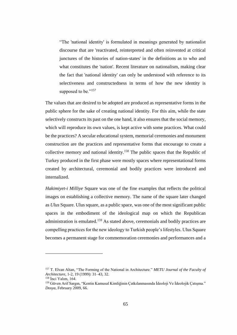
65
“The 'national identity' is formulated in meanings generated by nationalist
discourse that are 'reactivated, reinterpreted and often reinvented at critical
junctures of the histories of nation-states' in the definitions as to who and
what constitutes the 'nation'. Recent literature on nationalism, making clear
the fact that 'national identity' can only be understood with reference to its
selectiveness and constructedness in terms of how the new identity is
supposed to be.”157
The values that are desired to be adopted are produced as representative forms in the
public sphere for the sake of creating national identity. For this aim, while the state
selectively constructs its past on the one hand, it also ensures that the social memory,
which will reproduce its own values, is kept active with some practices. What could
be the practices? A secular educational system, memorial ceremonies and monument
construction are the practices and representative forms that encourage to create a
collective memory and national identity.158 The public spaces that the Republic of
Turkey produced in the first phase were mostly spaces where representational forms
created by architectural, ceremonial and bodily practices were introduced and
internalized.
Hakimiyet-i Milliye Square was one of the fine examples that reflects the political
images on establishing a collective memory. The name of the square later changed
as Ulus Square. Ulus square, as a public space, was one of the most significant public
spaces in the embodiment of the ideological map on which the Republican
administration is emulated.159 As stated above, ceremonials and bodily practices are
compelling practices for the new ideology to Turkish people’s lifestyles. Ulus Square
becomes a permanent stage for commemoration ceremonies and performances and a
157 T. Elvan Altan, “The Forming of the National in Architecture.” METU Journal of the Faculty of
Architecture, 1-2, 19 (1999): 31–43, 32. 158 İnci Yalım, 164. 159 Güven Arif Sargın, “Kentin Kamusal Kimliğinin Çatkılanmasında İdeoloji Ve İdeolojik Çatışma.”
Dosya, February 2009, 66.
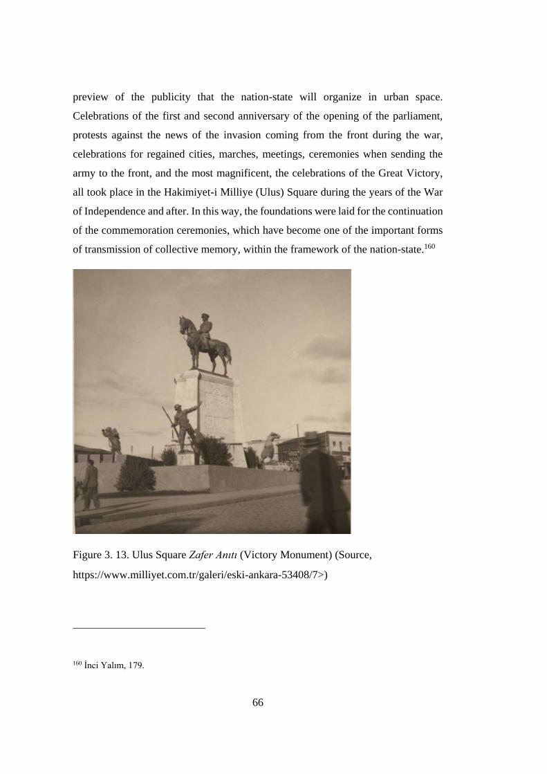
66
preview of the publicity that the nation-state will organize in urban space.
Celebrations of the first and second anniversary of the opening of the parliament,
protests against the news of the invasion coming from the front during the war,
celebrations for regained cities, marches, meetings, ceremonies when sending the
army to the front, and the most magnificent, the celebrations of the Great Victory,
all took place in the Hakimiyet-i Milliye (Ulus) Square during the years of the War
of Independence and after. In this way, the foundations were laid for the continuation
of the commemoration ceremonies, which have become one of the important forms
of transmission of collective memory, within the framework of the nation-state.160
Figure 3. 13. Ulus Square Zafer Anıtı (Victory Monument) (Source,
https://www.milliyet.com.tr/galeri/eski-ankara-53408/7>)
160 İnci Yalım, 179.
67
Figure 3. 14. Celebration of the Republic at Ulus Square around the Victory
Monument. (Source,
< https://historyontheorientexpress.tumblr.com/image/172682880091>)

68
3.3.2 The Role of Monuments in the Construction of Collective Memory
In the process of constructing and reproducing social and collective identity and
memory within the framework of the established nation-state, monuments have a
significant role. A monument is the physical structure in which the idealized images
are brought together to form a discourse. In addition, it is a structure that enables to
remember a selected past in the perspective of the present.161 “Monuments are
usually paid for or at least sanctioned by the state and represent what must be
remembered according to established power, although they can also stand for
challenges to that power.”162 As well as remembering, with monuments, there could
also be selected ideologies that had to be forgotten. There are several achievements
that were meant to be gained through monuments. The space which a monument
defines may also become a platform of democratic attendance. The location turns
into a special place for commemorating specific events or military triumphs. Here,
the monuments that were planned to be positioned at critical points of the city,
obviously points to a new cultural sphere and an apparatus on the way to make people
adopt the new identity.
The first of monument in Ankara was the Zafer Anıtı (Victory Monument) created
in 1927 by the Austrian sculptor Heinrich Krippel. The Victory Monument was built
under the leadership of Yunus Nadi Bey, owner of Yeni Gün Newspaper, with the
financial contributions of the Turkish nation. A nationwide campaign was launched
to have the monument built.163 The monument was composed of an equestrian statue
of Atatürk on the top of a plinth, with two ‘‘Mehmetcik,’’ the Turkish soldier and
the Turkish woman carrying ammunition to the battlefront, a composition that
161 İnci Yalım, 196. 162 Mark Crinson, Urban Memory History and Amnesia in the Modern City (London: Routledge,
2005), xvi. 163 “Atatürk Hakkında Bilmek İstediğiniz Herşey.” İşte Atatürk. Accessed July 1, 2021.
https://isteataturk.com/g/icerik/Ulus-Ataturk-Aniti-Ankara/1470.
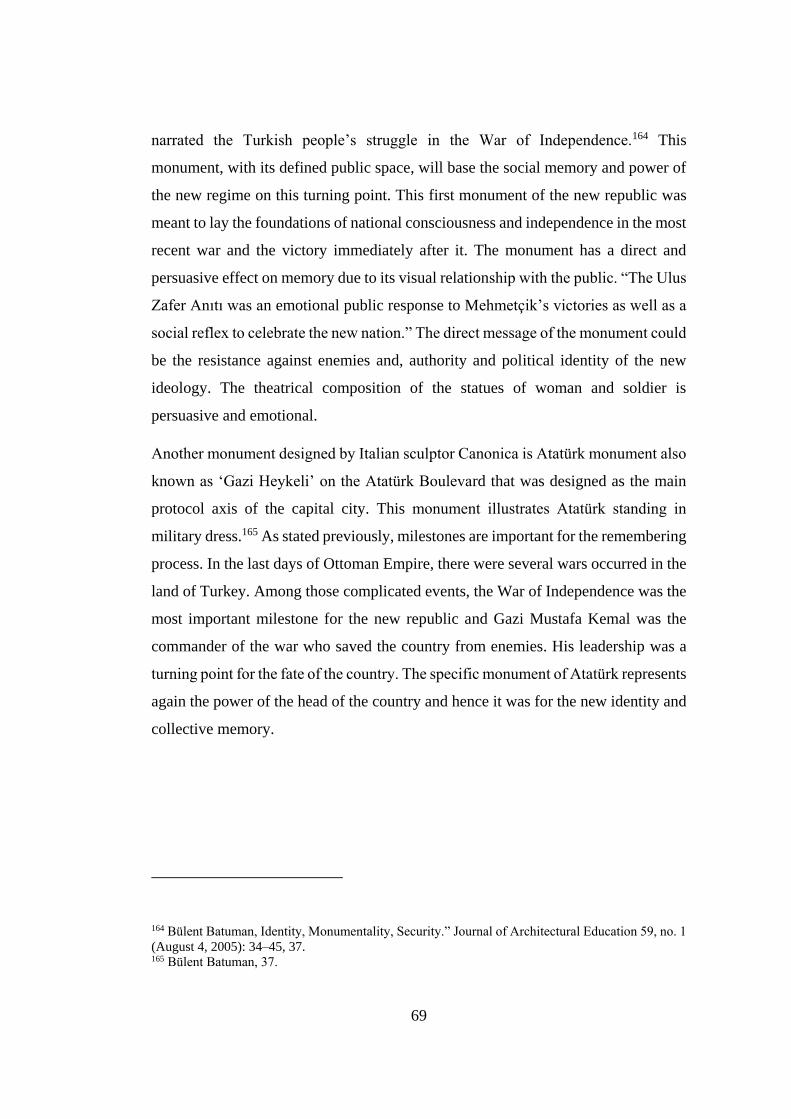
69
narrated the Turkish people’s struggle in the War of Independence.164 This
monument, with its defined public space, will base the social memory and power of
the new regime on this turning point. This first monument of the new republic was
meant to lay the foundations of national consciousness and independence in the most
recent war and the victory immediately after it. The monument has a direct and
persuasive effect on memory due to its visual relationship with the public. “The Ulus
Zafer Anıtı was an emotional public response to Mehmetçik’s victories as well as a
social reflex to celebrate the new nation.” The direct message of the monument could
be the resistance against enemies and, authority and political identity of the new
ideology. The theatrical composition of the statues of woman and soldier is
persuasive and emotional.
Another monument designed by Italian sculptor Canonica is Atatürk monument also
known as ‘Gazi Heykeli’ on the Atatürk Boulevard that was designed as the main
protocol axis of the capital city. This monument illustrates Atatürk standing in
military dress.165 As stated previously, milestones are important for the remembering
process. In the last days of Ottoman Empire, there were several wars occurred in the
land of Turkey. Among those complicated events, the War of Independence was the
most important milestone for the new republic and Gazi Mustafa Kemal was the
commander of the war who saved the country from enemies. His leadership was a
turning point for the fate of the country. The specific monument of Atatürk represents
again the power of the head of the country and hence it was for the new identity and
collective memory.
164 Bülent Batuman, Identity, Monumentality, Security.” Journal of Architectural Education 59, no. 1
(August 4, 2005): 34–45, 37. 165 Bülent Batuman, 37.

70
Figure 3. 15 Atatürk Statue (Gazi Heykeli) on the Atatürk Boulevard.
(https://i.pinimg.com/originals/cb/52/f1/cb52f1e7249f9aa92b73fe63b2468db4.jpg)
Except for the above monuments, there was another masterpiece called as Zabıta
Abidesi, later its name was changed as Güvenlik Anıtı. It was designed by the
Austrian sculptors Anton Hanak and Josef Thorak in 1931. The location of the
monument is in the Kızılay Park facing towards the square.
“In his proposal, a massive eight- by ten-meter block rested on top of a raised
platform, the sides of which contained two-meter high reliefs. There would
be two bronze male figures in front of the block, depicting a police officer
and a gendarme in their uniforms. For the other side of the block, Hanak
proposed a relief entitled ‘the Family,’ with a larger mother figure in the
center embracing her children, with five small figures surrounding her and
taking refuge under her extended arms”166
166 Batuman, 38.
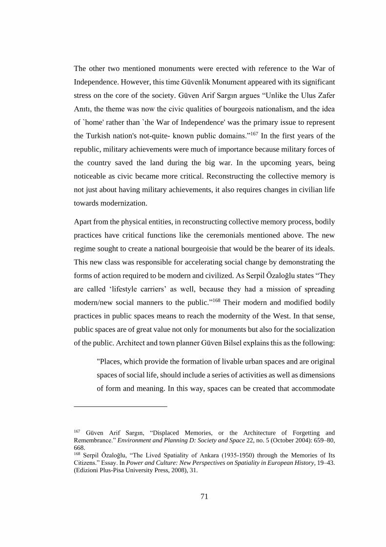
71
The other two mentioned monuments were erected with reference to the War of
Independence. However, this time Güvenlik Monument appeared with its significant
stress on the core of the society. Güven Arif Sargın argues “Unlike the Ulus Zafer
Anıtı, the theme was now the civic qualities of bourgeois nationalism, and the idea
of `home' rather than `the War of Independence' was the primary issue to represent
the Turkish nation's not-quite- known public domains.”167 In the first years of the
republic, military achievements were much of importance because military forces of
the country saved the land during the big war. In the upcoming years, being
noticeable as civic became more critical. Reconstructing the collective memory is
not just about having military achievements, it also requires changes in civilian life
towards modernization.
Apart from the physical entities, in reconstructing collective memory process, bodily
practices have critical functions like the ceremonials mentioned above. The new
regime sought to create a national bourgeoisie that would be the bearer of its ideals.
This new class was responsible for accelerating social change by demonstrating the
forms of action required to be modern and civilized. As Serpil Özaloğlu states “They
are called ‘lifestyle carriers’ as well, because they had a mission of spreading
modern/new social manners to the public.”168 Their modern and modified bodily
practices in public spaces means to reach the modernity of the West. In that sense,
public spaces are of great value not only for monuments but also for the socialization
of the public. Architect and town planner Güven Bilsel explains this as the following:
"Places, which provide the formation of livable urban spaces and are original
spaces of social life, should include a series of activities as well as dimensions
of form and meaning. In this way, spaces can be created that accommodate
167 Güven Arif Sargın, “Displaced Memories, or the Architecture of Forgetting and
Remembrance.” Environment and Planning D: Society and Space 22, no. 5 (October 2004): 659–80,
668. 168 Serpil Özaloğlu, “The Lived Spatiality of Ankara (1935-1950) through the Memories of Its
Citizens.” Essay. In Power and Culture: New Perspectives on Spatiality in European History, 19–43.
(Edizioni Plus-Pisa University Press, 2008), 31.
72
urbanism as a way of life and where different social groups come together
and are in communication.”169
Public places were just a great opportunity for nurturing an urban culture and
displaying a series of activities. These places are suitable platforms for people from
similar social groups to encounter and get in touch with each other. Ulus Square was
used for ceremonials, protests, meetings etc. The square was also used for daily
purposes of the public such as meeting with friends, family walks through the square
or just a transition area between markets. These defined the square in a social aspect.
Figure 3. 16. Havuzbaşı Statue in Kızılay Square.
(https://i.pinimg.com/originals/e5/ae/dc/e5aedc92ebd10da0405842b796e5e703.jpg)
In the new city region in Ankara, there was a fountain located in the middle of the
Kızılay Square. “A fountain with a baroque bronze statue of a female figure with
nymphs. Later the square was named as Havuzbaşı.”170 Around the fountain became
a recreational area and in time, the place turned into a gathering point for the new
169 S. Güven Bilsel, “Kent ve Kentli Kültürü, Kimlik Sorunsalı, Yaşanılası Kentsel Mekan ve
Ankara.” Dosya, February 2009, 51. 170 Bülent Batuman, “Identity, Monumentality, Security,” 36.
73
national bourgeoisie. There were concerts, live musics held in the square. With such
organizations, public life began to change in the light of modernism.
“Some embassies also contributed to the new music movement initiated by
the Republic; the Soviet Union had people listen a concert from Moscow,
with the initiative of Germany, an international pianist such as Professor
Kempf offered concerts to people of Ankara at the Embassy and Halkevi
(People’s House). These were featured in the newspaper news as
unforgettable music evenings. In addition, the Presidential Orchestra giving
concerts in Havuzbaşı, which is organized as a park in Yenişehir, is another
indication of this purpose plan.”171
This social change, which was realized in accordance with the Western culture, could
only be possible with the personalization of individuals in their bodily practices with
such above mentioned organizations. The transformation of these practices into a
habit would play an important role in forming the national identity and collective
memory of the Republic that defines itself in the international arena, starting from
the individual and reaching the social level.
171 İnci Aslanoğlu, “1930-50 Yılları Ankara’sının Eğlence Yaşamı İçinde Gazino Binaları”, Essay, In
In Tarih icinde Ankara II Aralık 1998 Seminer Bildirileri, 327-340. (Ankara: ODTÜ, 2001), 328.

74
75
4 CHAPTER 4
HERGELEN SQUARE AND MELİKE HATUN MOSQUE
Throughout history, Ankara has hosted many civilizations. The city has undergone
many material and spiritual changes. Sometimes it was in its golden age, and
sometimes it became untouched due to neglect. Before the proclamation of the
Republic, the city looks like a neglected and devastated provincial town due to wars.
In such an atmosphere, Hergelen Square was one of the essential points of Ankara.
It was also one of the critical squares of Ankara in the years after the Republic. In
line with the plans made for the capital city, suggestions were made for Hergelen
Square. None of these proposals could be realized for a variety of reasons. Over time,
it has lost its function and importance with the interventions made. According to the
latest arrangement, there is Melike Hatun Mosque in Hergelen Square today. With
the effects of all these interventions, the square has a disintegrated character.
Undoubtedly, this non-holistic character is reflected in the memory of place and the
collective memory.
In order to understand the past developments of the area thoroughly, it is necessary
to know today’s definers of the square. That is why this chapter begins with the space
defining elements in the surrounding of the square. With a concrete image of today’s
condition of the site, the historical developments will be examined next. Then the
square will be considered from social and cultural perspectives. Specially, the
sculpture of Otto Herbert Hajek that was placed next to this square in 1990s will be
examined. Because Hajek's sculpture is critical to the historical and socio-cultural
development of the square. According to the latest arrangement in Ulus, Melike
Hatun Mosque was built on the square. The mosque is quite a different structure in
terms of its scale and architecture. The architecture of the structure has had a strong
76
on the spatial character of the square. The architecture of the mosque and its relation
with Hergelen Square will be studied under separate section.
4.1 Space Defining Elements in Hergelen Square
At the end of the 19th century, Ankara looked like a small and neglected town and it
had a poor economy. After the railway reached Ankara in 1892 and later after the
city was declared the capital of the Republic, there was an improvement in the city’s
economy. The enhancement in the economy and the increase in trade caused changes
in the spatial structure of the city. One of the areas where this change is clearly
observed is Hergelen Square. The train station is located on the south-west side of
the town according to Ankara castle. Hergelen Square is located between the train
station and the settlements on the southeastern outskirts of the castle hill. “It
functioned as a kind of gate-way or gathering point orientating people to Ankara
Castle. In fact it was a public space welcoming outsiders or travelers and facilitating
their engagement with the active town life.”172 With this feature, the area was
actually a lively urban point placed in a historic place close to Ankara castle. Before
examining the developments of the square in detail, the elements that define the
square today will be examined. To understand today’s condition, location and the
definers of the square eases to understand its modifications in the past and to evaluate
the transition in collective memory.
Hermann Jansen proposed a development plan for Ankara in 1929. Jansen planned
the city as consisting of two main transportation axes. The first one starts from
Ankara castle towards Çankaya. This axis is called Atatürk Boulevard. Elif
Mıhçıoğlu explains this as:
172 Emre Demirel, . “The Haptic and Visual Considerations of Public Spaces: Otto Herbert Hajek’s
Proposal for Hergelen Square in Ankara.” Online Journal of Art and Design 7, no. 1 (January 2019):
202–19, 205.
77
“The major artery of the whole city center for the first time, modifying the
existing avenues of Bankalar (or Dar-ül Muallimin), former Cumhuriyet,
Çankırı Avenues, and connecting them on north-south axis. This axis was
planned as the most important artery connecting the Old City to the New City
with a holistic approach.”173
Most of the buildings were governmental buildings on that axis. The second one
(İstanbul and Adnan Saygun Streets today) started from Atatürk Orman Çiftliği and
continued with parks including the project of Youth Park, recreational areas, and
sport areas.174 Two major axes intersects at the point of Hergelen Square. This
situation turns the square into a strategic point. This intersection point actually was
like an open-air architecture museum where Republican and modernization
ideologies dominated. There are many buildings that still exist today around the area.
The Youth Park (Gençlik Parkı) is also one of the main definers, a significant public
space opening to Hergelen square. The main pedestrian axis of the park connects the
central station to this square. The first differentiation in the spatial structure of the
square was made in order to meet the accommodation requirements of the passengers
coming to the city.175 Still today there are several hotels on the east side of the square.
There are precious republican buildings that define most of the borders of Hergelen
Square: the Ottoman Bank (1926), TEKEL Directorate Building (1928) and Ziraat
Bankası (1926-29) by Giulio Mongeri, 2nd Vakıf Apartment (1928-30) by Kemalettin
Bey, Exhibition House (1933) by Şevki Balmumcu, Emlak Bankası (1933-34) by
Clemens Holzmeister, Gazi High School (1936) by Ernst A. Egli, İller Bankası
(1937) by Seyfi Arkan and lastly The Youth Park (1936-43).
173 Elif Mıhçıoğlu, “The Physical Evolution of The Historic City of Ankara Between 1839 and 1944:
A Morphological Analysis” (PhD Thesis, Middle East Technical University, n.d.), 208. 174 Serpil Özaloğlu, “İller Bankası’nın Yıktırılmasının Düşündürdükleri,”
http://www.arkitera.com/gorus/1054/iller-bankasinin-yiktirilmasinin-dusundurdukleri (accessed
December 10, 2018). 175 Çiğdem Belgin Tipi “Hergelen Meydanı Çevre Düzenleme ve Korumasına İişkin Öneriler” (M.Sc.
diss., Gazi Üniversitesi, 1996), 100.
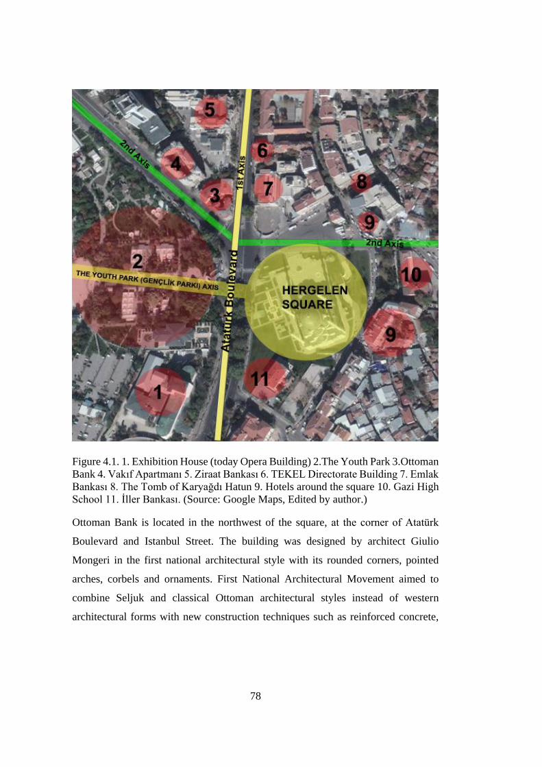
78
Figure 4.1. 1. Exhibition House (today Opera Building) 2.The Youth Park 3.Ottoman
Bank 4. Vakıf Apartmanı 5. Ziraat Bankası 6. TEKEL Directorate Building 7. Emlak
Bankası 8. The Tomb of Karyağdı Hatun 9. Hotels around the square 10. Gazi High
School 11. İller Bankası. (Source: Google Maps, Edited by author.)
Ottoman Bank is located in the northwest of the square, at the corner of Atatürk
Boulevard and Istanbul Street. The building was designed by architect Giulio
Mongeri in the first national architectural style with its rounded corners, pointed
arches, corbels and ornaments. First National Architectural Movement aimed to
combine Seljuk and classical Ottoman architectural styles instead of western
architectural forms with new construction techniques such as reinforced concrete,
79
iron and steel.176 TEKEL Directorate and Ziraat Bankası were also designed by
Giulio Mongeri and located in the northwest side of the square on the Atatürk
Boulevard. General Directorate of the State Monopolies (TEKEL –İnhisarlar İdaresi)
is a modest, charming example of the National Style of the late 1920s.177 Typical
corner tower of the movement was preferred. Structural and decorative elements of
Ottoman architecture were used in the details. This building is mostly considered as
strong representative of the First National Style with its well-fit styling and balanced
scale.
Ziraat Bankası that was also designed by Giulio Mongeri, is also an outcome of the
same movement in those years. The building has a wide and high rectangular hall.
The ceiling of the hall, which is the main place of the building, is covered with large
colored stained glass. With its huge, bastion-like corner towers and very high storeys,
the Agricultural Bank seems somewhat out of proportion with its immediate
environment, particularly when compared with TEKEL building.178 Shaped with
Seljuk and Ottoman architectural elements, the front facades were designed
symmetrically to the entrance, while the rear and side facades were designed more
simply. With raising the corner masses in buildings, separating the floors with
moldings, using Seljuk motifs on the wide eaves, for each floor, use of different
arched windows, overhangs, domes and pilasters, these structures reflect the
characteristics of the 1st National Architecture style.
Vakıf Apartmanı is also an example from the First National Architectural Movement
by Kemalettin Bey. It is located next to the Ottoman Bank, which is in the northwest
side of the square too. “Second Vakıf Hanı stands out as the most interesting
apartment, with forty rental apartment units of various sizes, double-storey shops on
176 Damla Çinici, “Başkent Ankara’Nın İnşasında Etkin Bir Mimar: Giulio Mongeri Ve Yaşam
Öyküsü.” Ankara Araştırmaları Dergisi 3, no. 1 (June 14, 2015), 25. 177 Yıldırım Yavuz and Süha Özkan, Essay, in Modern Turkish Architecture, 55-68. (Chamber of
Architects: Ankara, 2005), 63. 178 Yıldırım Yavuz and Süha Özkan, 63

80
the ground level, and a sizeable auditorium for the performing arts at its center.”179
Many technological innovations have been applied according to the conditions of the
time like central heating, elevators, modern bathroom fixtures etc. This structure was
built with the reinforced concrete technique, which has been applied extensively. It
includes the possibilities offered by this technique among all the productions made
by its architect.
Between 1933 and 1934, the building was first constructed by architect Şevki
Balmumcu as an Exhibition House and later converted into an opera house by Paul
Bonatz. Opera Building was important for the social and cultural activities in Ankara.
Since there was one Opera Building in the city, the cultural circulation has also
affected Hergelen Square. It is located in the southwest side of the square. This
structure has taken its place as a great success in the architectural environment of
Turkey. It was kind of a representative of the modernization movement of the period.
During the 1930s and the first half of the 1940s, the building hosted many national
and international exhibitions. It was transformed into Theater and Opera Stage in
1946 by the decision of Ministry of Education.180 For this transformation, there were
lots of changes made in the physical appearance. Its façade has become very different
from the original.
In 1934-35, Celemens Holzmeister designed Emlak Bankası building. When
examined from the outside, it shows a similar form of Holzmeister structures (like
ministry buildings) and a formalist approach that conforms to neo-classical
architecture. Marble and Ankara stone are specifically used materials. The reinforced
concrete construction is three storey with a basement. Emlak Bankası is located in
the north of the square. In the east side of the square, there is Gazi High School which
was designed by Ernst Arnold Egli. He was a pioneering modernist architect during
the Republican Period. The façade of the L-shaped mass was designed in accordance
179 Ibid., 60. 180 Elvan Altan Ergut, “Bina Kimlikleri Söyleşisi 5 ‘Sergi Evi ve Opera Binası.’”
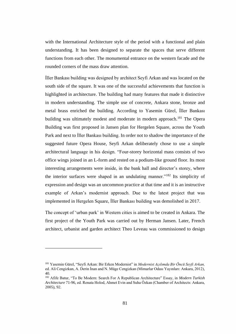
81
with the International Architecture style of the period with a functional and plain
understanding. It has been designed to separate the spaces that serve different
functions from each other. The monumental entrance on the western facade and the
rounded corners of the mass draw attention.
İller Bankası building was designed by architect Seyfi Arkan and was located on the
south side of the square. It was one of the successful achievements that function is
highlighted in architecture. The building had many features that made it distinctive
in modern understanding. The simple use of concrete, Ankara stone, bronze and
metal brass enriched the building. According to Yasemin Gürel, İller Bankası
building was ultimately modest and moderate in modern approach.181 The Opera
Building was first proposed in Jansen plan for Hergelen Square, across the Youth
Park and next to İller Bankası building. In order not to shadow the importance of the
suggested future Opera House, Seyfi Arkan deliberately chose to use a simple
architectural language in his design. “Four-storey horizontal mass consists of two
office wings joined in an L-form and rested on a podium-like ground floor. Its most
interesting arrangements were inside, in the bank hall and director’s storey, where
the interior surfaces were shaped in an undulating manner.”182 Its simplicity of
expression and design was an uncommon practice at that time and it is an instructive
example of Arkan’s modernist approach. Due to the latest project that was
implemented in Hergelen Square, İller Bankası building was demolished in 2017.
The concept of ‘urban park’ in Western cities is aimed to be created in Ankara. The
first project of the Youth Park was carried out by Herman Jansen. Later, French
architect, urbanist and garden architect Theo Leveau was commissioned to design
181 Yasemin Gürel, “Seyfi Arkan: Bir Erken Modernist” in Modernist Acılımda Bir Öncü Seyfi Arkan,
ed. Ali Cengizkan, A. Derin İnan and N. Müge Cengizkan (Mimarlar Odası Yayınları: Ankara, 2012),
40. 182 Afife Batur, “To Be Modern: Search For A Republican Architecture” Essay, in Modern Turkish
Architecture 71-96, ed. Renata Holod, Ahmet Evin and Suha Özkan (Chamber of Architects: Ankara,
2005), 92.
82
the Park.183 In the 30s, before the Youth Park was opened, there were no venues for
activities other than the Güven Park and Kızılay Garden in Yenişehir, a few coffee
shops, a couple of restaurants and a cinema. The opening of the Youth Park was the
most important intervention that changed the daily life of the city dwellers.184 The
park was designed to accommodate a variety of entertainment, recreation and sports
opportunities for everyone, from children to the elderly. It was opened in 1943. The
park has undertaken the task of being an urban park that reflects the modern and
attractive atmosphere of Ankara and at the same time represented the ideals of the
republic.
Lastly, on the northeast side of the square, on one of the backstreets (Doğan Street),
there is a historic tomb, a “türbe” that has had an importance for the citizens of
Ankara. The Tomb of Karyağdı Hatun was built in 1577.185 Culturally, the people of
Ankara go to the tomb and make their prayers commemorating Karyağdı Hatun.
Especially at weekends, going to tomb is one of the social activities of the people.
183 Erman Tamur, Suda Suretimiz cıkıyor: Ankara Dereleri üzerine Tarihi Ve güncel Bilgiler (Ankara:
Kebikeç, 2012), 105. 184 Zeynep Uludağ, and Hilal Aycı. “Modernin Güçlü Sahnesi Erken Cumhuriyet Dönemi
Ankara’Sında Kolektif Belleğin İnşası Ve Toplumsal Unutma Süreci.” Kent Araştırmaları Dergisi 7,
no. 20 (December 2016), 757 185 Ayça Nur Kip Akyol, “Karyağdı Hatun Türbesinden Operaya Bir Opera Etnografisi” (Phd. diss.,
Ankara Üniversitesi, 2016), 47.
83
Figure 4. 2. (Left Picture) The Tomb of Karyağdı Hatun (Source:
http://wowturkey.com/forum/viewtopic.php?t=6799&start=195)
Figure 4. 3. (Right Picture) The entrance of the tomb. (Source: Ayça Nur Kip
Akyol)
Figure 4. 4. Tomb of Karyağdı in 1923. (Source: VEKAM Digital Archive,
https://libdigitalcollections.ku.edu.tr/digital/search/searchterm/hergele)
When examining the elements that define the square, each of them plays a crucial
role in Ankara's nation-state building process and socio-cultural life of the city. From
this point of view, this location has a critical importance in the construction of urban,
architectural and collective memories of Ankara residents. From the first national
84
architecture movement to international style, there are various styles that have been
applied to the buildings around Hergelen Square. These styles were adopted by the
new and young Republic. The Youth Park and the Tomb of Karyağdı Hatun define
Hergelen Square from recreational, cultural and social uses. There is a variety in the
elements that define the square. All those above mentioned structures are in line with
Republican ideology. Suggestions were made for the square to support this ideology,
but none of them were fully implemented. This caused the square to have a
disintegrated character. Nowadays, with the latest arrangement for the square, a new
perspective has been added. The Melike Hatun Mosque design and square
arrangement gave the square a completely new religious meaning. The next section
covers the developments of the square from the past to the present.
4.2 Development of Hergelen Square
Before examining the development process of Hergelen Square in detail, the physical
construction in Islamic cities and later in Turkish and Ottoman cities will be briefly
mentioned.
The old Turkish cities present a tripartite structure consisting of kale (castle),
şehristan (city) and rabad parts. The inner castle was surrounded by a strong wall
with towers. The şehristan in which the castle is located is also limited by walls. In
the şehristan, where the big neighborhoods are located, the houses are built close to
each other. Rabad is the area where more commercial activities take place, outside
kale and şehristan.186
The concept of the “Islamic city” is defined as an urban image with external features
such as a winding narrow street, a dead-end street, a house with a courtyard.187 The
186 Adalet Bayramoğlu Alada, Osmanlı Şehrinde Mahalle (İstanbul: Sümer Kitabevi, 2008), 31, 32. 187 Stefan Yerasimos, “Tanzimat’ın Kent Reformları Üzerine,” Essay, In Modernleşme Sürecinde
Osmanlı Kentleri, 1-18. (İstanbul: Tarhi Vakfı Yurt Yayınları, 1996), 10.
85
Islamic city presents a functionally triple spatial and institutional structure consisting
of the large mosque located in the center, the bazaar and commercial units around it,
service structures such as kervansaray, han, hamam, and separate neighborhoods.
The mosque not only constitutes a focal point for the arrangement of the physical
space of the city, but also has been evaluated as a social, political, intellectual and
legal center in addition to its religious functions. The mosque is considered the main
determinant in the establishment and integration of the community system.188 In
Islamic cities, it is also not clearly indicated that there was no large open areas. The
mosque has an essential role of urban design. There is a city structure that grows and
develops around the mosque which is located at the center. Stefan Yerasimos stated
that there is no public spaces in the Islamic city and he continues: “In addition to
private properties belonging to private individuals, the ruler and foundations, there
are areas that are under the common ownership of neighbors or the whole
community.”189 This is also valid for Ottoman cities. As a result of the introverted
Ottoman society and the political systems that dominate the society, there are no
planned public open spaces like squares in the cities. The open areas were formed
spontaneously around the masjid and fountain or in the markets.190 The reforms,
known as Tanzimat, which were initiated in the Ottoman Empire in the direction of
westernizing the state and society since 1839, also concern the urban decisions.191
After Tanzimat reforms, In Ottoman cities, changes began in the name of
westernization, especially in İstanbul. For example, “Government Square (Hükümet
or Vilayet Meydanı) created under the effect of Tanzimat reforms was the
governmental center since late 1890s, with a major spacious square in the city of
1924.”192
188 Alada, Osmanlı Şehrinde Mahalle (İstanbul: Sümer Kitabevi, 2008), 38. 189 Yerasimos, , “Tanzimat’ın Kent Reformları Üzerine,” 10. 190 Alpaslan Aliağaoğlu, and Abdullah Uğur, . “Osmanlı Şehri.” SDÜ Fen Edebiyat Fakültesi Sosyal
Bilimler Dergisi, 219. 191 Yerasimos, , “Tanzimat’ın Kent Reformları Üzerine,” 1. 192 Elif Mıhçıoğlu, “The Physical Evolution of The Historic City of Ankara Between 1839 and 1944:
A Morphological Analysis” (PhD Thesis, Middle East Technical University, 2010), 61.
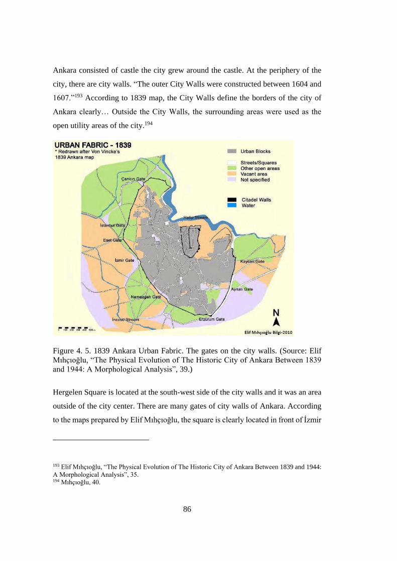
86
Ankara consisted of castle the city grew around the castle. At the periphery of the
city, there are city walls. “The outer City Walls were constructed between 1604 and
1607.”193 According to 1839 map, the City Walls define the borders of the city of
Ankara clearly… Outside the City Walls, the surrounding areas were used as the
open utility areas of the city.194
Figure 4. 5. 1839 Ankara Urban Fabric. The gates on the city walls. (Source: Elif
Mıhçıoğlu, “The Physical Evolution of The Historic City of Ankara Between 1839
and 1944: A Morphological Analysis”, 39.)
Hergelen Square is located at the south-west side of the city walls and it was an area
outside of the city center. There are many gates of city walls of Ankara. According
to the maps prepared by Elif Mıhçıoğlu, the square is clearly located in front of İzmir
193 Elif Mıhçıoğlu, “The Physical Evolution of The Historic City of Ankara Between 1839 and 1944:
A Morphological Analysis”, 35. 194 Mıhçıoğlu, 40.

87
Gate. As explained in the historical chapter of the thesis, Ankara was on the trade
route. The fact that Hergelen Square is located in front of one of the city's gates
shows that this square was a place where trade was made and caravans stopped.
Figure 4. 6. Ankara Urban Fabric. Hergelen Square is on the outer city walls.
(Source: Musa Kadıoğlu, et. al., Roma Döneminde Ankyra, 2018.)

88
Figure 4. 7. This map shows that Hergelen Square is located in front of İzmir Gate.
(Source: Elif Mıhçıoğlu, “The Physical Evolution of The Historic City of Ankara
Between 1839 and 1944: A Morphological Analysis”, 115.)
The map in the Figure 4.7 shows the change of urban fabric character from 1924 to
1930s with respect to the transformation of urban blocks and open areas.195
According to the analysis made by Elif Mıhçıoğlu, the 11th block indicated in the
map was transformed into Youth Park. And according to the Figure 4.5 which
indicates the gates of Ankara, Youth Park is located in front of İzmir Gate. Since
Hergelen Square is next to the Youth Park, the square is also located in front of İzmir
Gate.
195 Elif Mıhçıoğlu, “The Physical Evolution of The Historic City of Ankara Between 1839 and 1944:
A Morphological Analysis”, 113.
89
4.2.1 The Name of the Square
Squares, with their multi-layered living structure, are changing within the framework
of the dynamics developing within the city. For this reason, squares are in constant
contact with urban identity and urban memory. With the interventions in the squares,
the identity and memory of the city is changing. One of these interventions is naming.
“Naming the living environment with the language used by the society is important
in terms of integration with the geographical space. With naming, places or objects
have obtained identity.”196 Hergelen Square has also experienced many
interventions, developments and differentiation from the past to the present. As a
result, it has undergone many name changes; Hergele, Hergelen, Itfaiye, Opera.
Today, the square is known as Hergelen. Şeref Erdoğdu describes the square as
follows:
It is one of the oldest historical squares of Ankara. A very green plain
stretching from one end to the other. We can call it the hippodrome of those
years, surrounded by poplar trees… The characteristic of this plain is that the
heirloom cirit game is played here… Those who went to the military would
be sent off from this square again… People who had a stable in Ankara of
those years used to feed cows. They would take the cows to this square to
deliver them to the shepherd Kel Mevlüt. The shepherd would bring them
back to this area after grazing them. The herd of horses and cows in Anatolia,
especially in Ankara, is called Hergele. Over time, buildings were built. The
space has shrunk. A mill was built, it didn't work. Ankara Fire Department
(İtfaiye) settled in this building, it became the Itfaiye Square. Then the Opera
House was built, it became the Opera Square.197
196 Alpaslan Aliağaoğlu, and Alper Uzun, . “Şehirsel Toponimi (Hodonimi): Türkiye İçin Bir Tipoloji
Denemesi.” Coğrafi Bilimler Dergisi, 2, 9 (2011), 124. 197 Şeref Erdoğdu, Ankara'nın tarihi Semt Isimleri Ve öyküleri (Ankara: T.C. Kültür Bakanlığı, 2002),
73, 74.
90
Nevzat Gözaydın states that the name Hergele has another meaning. “Hergele”
means stray, dying old horse herds living on an empty plain watered by a stream
running through the city. Later, the bus terminal was opened. Since people from other
cities came there, its name started to be mentioned as Hergelen Square.198 The word
Hergelen means that everyone comes. Later, Ankara Fire Department found at
Hergelen Square. A senior fire officer stated that he came to the Fire Department in
Ankara in this square and worked there.199 Then the square named as İtfaiye, as Şeref
Erdoğdu indicated.
Naming the squares creates a memory for people. There are ideologies found in space
in a continuity. These ideologies take a place people's daily lives and in their
memories by naming. To change these ideologies adopted by people can occurr by
changing the names of places. Lorenzo Mantovani explains the importance of place
names as follows:
“The importance of place names lies in their ability to give an identity to a
place and to define its borders. Place names are also mnemonic codes for
local stories, activities and traditions. Thus they become important for two
reasons: first, they can tell us something about physical elements of a
landscape from centuries ago – thousands of years ago, in some cases.
Second, they give us an idea of the perceptions and memories of the local
communities, even when those physical elements are no longer present.”200
Elements that constitute the square are dynamic. People react differently to changing
conditions. City development, political reasons, land use and population size give
rise to different responses. As a matter of fact, the name change took place in
Hergelen Square due to various changes. While it was a free place where animals
roamed around, the name was wanted to be changed to Opera because the Opera
198 Nevzat Gözaydın, “Başkent’Te Yer Adları Üzerine.” Türk Dili 68, no. 794 (February 2018), 24. 199 Abdurrahman Kılıç, “Bir İtfaiye Duayeni Baki Akansel”, 2. 200 Lorenzo Mantovani, . “Philology and Toponymy. Commons, Place Names and Collective
Memories in the Rural Landscape of Emilia.” Philology 2 (2016), 242.
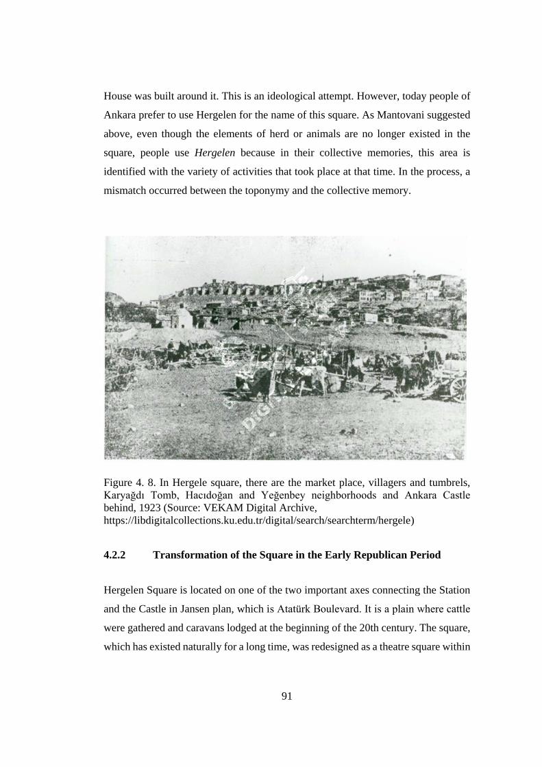
91
House was built around it. This is an ideological attempt. However, today people of
Ankara prefer to use Hergelen for the name of this square. As Mantovani suggested
above, even though the elements of herd or animals are no longer existed in the
square, people use Hergelen because in their collective memories, this area is
identified with the variety of activities that took place at that time. In the process, a
mismatch occurred between the toponymy and the collective memory.
Figure 4. 8. In Hergele square, there are the market place, villagers and tumbrels,
Karyağdı Tomb, Hacıdoğan and Yeğenbey neighborhoods and Ankara Castle
behind, 1923 (Source: VEKAM Digital Archive,
https://libdigitalcollections.ku.edu.tr/digital/search/searchterm/hergele)
4.2.2 Transformation of the Square in the Early Republican Period
Hergelen Square is located on one of the two important axes connecting the Station
and the Castle in Jansen plan, which is Atatürk Boulevard. It is a plain where cattle
were gathered and caravans lodged at the beginning of the 20th century. The square,
which has existed naturally for a long time, was redesigned as a theatre square within
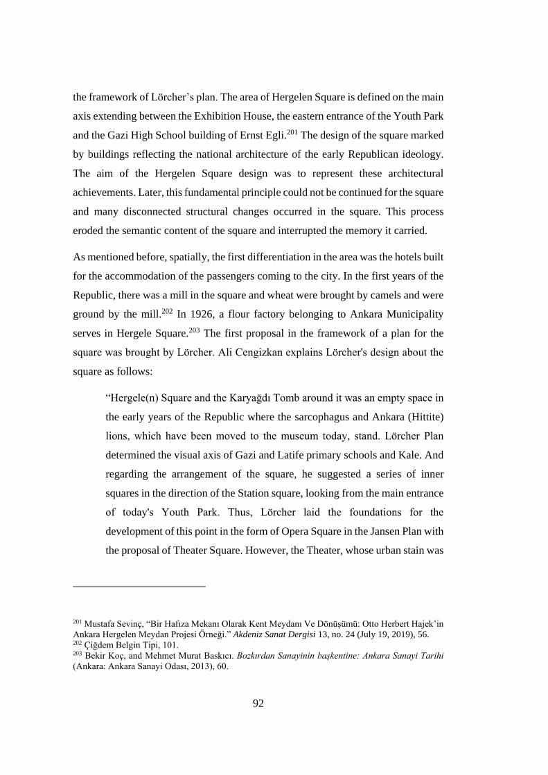
92
the framework of Lörcher’s plan. The area of Hergelen Square is defined on the main
axis extending between the Exhibition House, the eastern entrance of the Youth Park
and the Gazi High School building of Ernst Egli.201 The design of the square marked
by buildings reflecting the national architecture of the early Republican ideology.
The aim of the Hergelen Square design was to represent these architectural
achievements. Later, this fundamental principle could not be continued for the square
and many disconnected structural changes occurred in the square. This process
eroded the semantic content of the square and interrupted the memory it carried.
As mentioned before, spatially, the first differentiation in the area was the hotels built
for the accommodation of the passengers coming to the city. In the first years of the
Republic, there was a mill in the square and wheat were brought by camels and were
ground by the mill.202 In 1926, a flour factory belonging to Ankara Municipality
serves in Hergele Square.203 The first proposal in the framework of a plan for the
square was brought by Lörcher. Ali Cengizkan explains Lörcher's design about the
square as follows:
“Hergele(n) Square and the Karyağdı Tomb around it was an empty space in
the early years of the Republic where the sarcophagus and Ankara (Hittite)
lions, which have been moved to the museum today, stand. Lörcher Plan
determined the visual axis of Gazi and Latife primary schools and Kale. And
regarding the arrangement of the square, he suggested a series of inner
squares in the direction of the Station square, looking from the main entrance
of today's Youth Park. Thus, Lörcher laid the foundations for the
development of this point in the form of Opera Square in the Jansen Plan with
the proposal of Theater Square. However, the Theater, whose urban stain was
201 Mustafa Sevinç, “Bir Hafıza Mekanı Olarak Kent Meydanı Ve Dönüşümü: Otto Herbert Hajek’in
Ankara Hergelen Meydan Projesi Örneği.” Akdeniz Sanat Dergisi 13, no. 24 (July 19, 2019), 56. 202 Çiğdem Belgin Tipi, 101. 203 Bekir Koç, and Mehmet Murat Baskıcı. Bozkırdan Sanayinin başkentine: Ankara Sanayi Tarihi
(Ankara: Ankara Sanayi Odası, 2013), 60.
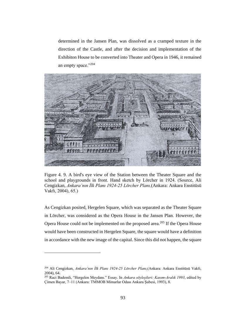
93
determined in the Jansen Plan, was dissolved as a cramped texture in the
direction of the Castle, and after the decision and implementation of the
Exhibiton House to be converted into Theater and Opera in 1946, it remained
an empty space.”204
Figure 4. 9. A bird's eye view of the Station between the Theater Square and the
school and playgrounds in front. Hand sketch by Lörcher in 1924. (Source, Ali
Cengizkan, Ankara’nın Ilk Planı 1924-25 Lörcher Planı,(Ankara: Ankara Enstitüsü
Vakfı, 2004), 65.)
As Cengizkan posited, Hergelen Square, which was separated as the Theater Square
in Lörcher, was considered as the Opera House in the Jansen Plan. However, the
Opera House could not be implemented on the proposed area.205 If the Opera House
would have been constructed in Hergelen Square, the square would have a definition
in accordance with the new image of the capital. Since this did not happen, the square
204 Ali Cengizkan, Ankara’nın Ilk Planı 1924-25 Lörcher Planı,(Ankara: Ankara Enstitüsü Vakfı,
2004), 64. 205 Raci Bademli, “Hergelen Meydanı.” Essay. In Ankara söyleşileri: Kasım-Aralık 1993, edited by
Çimen Bayar, 7–11 (Ankara: TMMOB Mimarlar Odası Ankara Şubesi, 1993), 8.
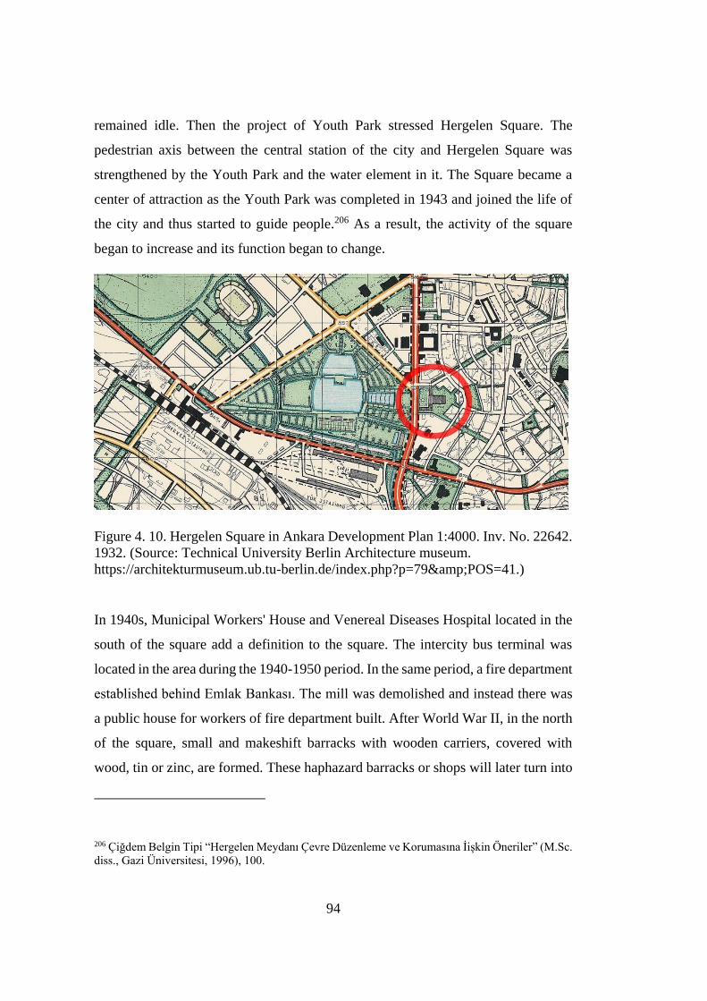
94
remained idle. Then the project of Youth Park stressed Hergelen Square. The
pedestrian axis between the central station of the city and Hergelen Square was
strengthened by the Youth Park and the water element in it. The Square became a
center of attraction as the Youth Park was completed in 1943 and joined the life of
the city and thus started to guide people.206 As a result, the activity of the square
began to increase and its function began to change.
Figure 4. 10. Hergelen Square in Ankara Development Plan 1:4000. Inv. No. 22642.
1932. (Source: Technical University Berlin Architecture museum.
https://architekturmuseum.ub.tu-berlin.de/index.php?p=79&POS=41.)
In 1940s, Municipal Workers' House and Venereal Diseases Hospital located in the
south of the square add a definition to the square. The intercity bus terminal was
located in the area during the 1940-1950 period. In the same period, a fire department
established behind Emlak Bankası. The mill was demolished and instead there was
a public house for workers of fire department built. After World War II, in the north
of the square, small and makeshift barracks with wooden carriers, covered with
wood, tin or zinc, are formed. These haphazard barracks or shops will later turn into
206 Çiğdem Belgin Tipi “Hergelen Meydanı Çevre Düzenleme ve Korumasına İişkin Öneriler” (M.Sc.
diss., Gazi Üniversitesi, 1996), 100.
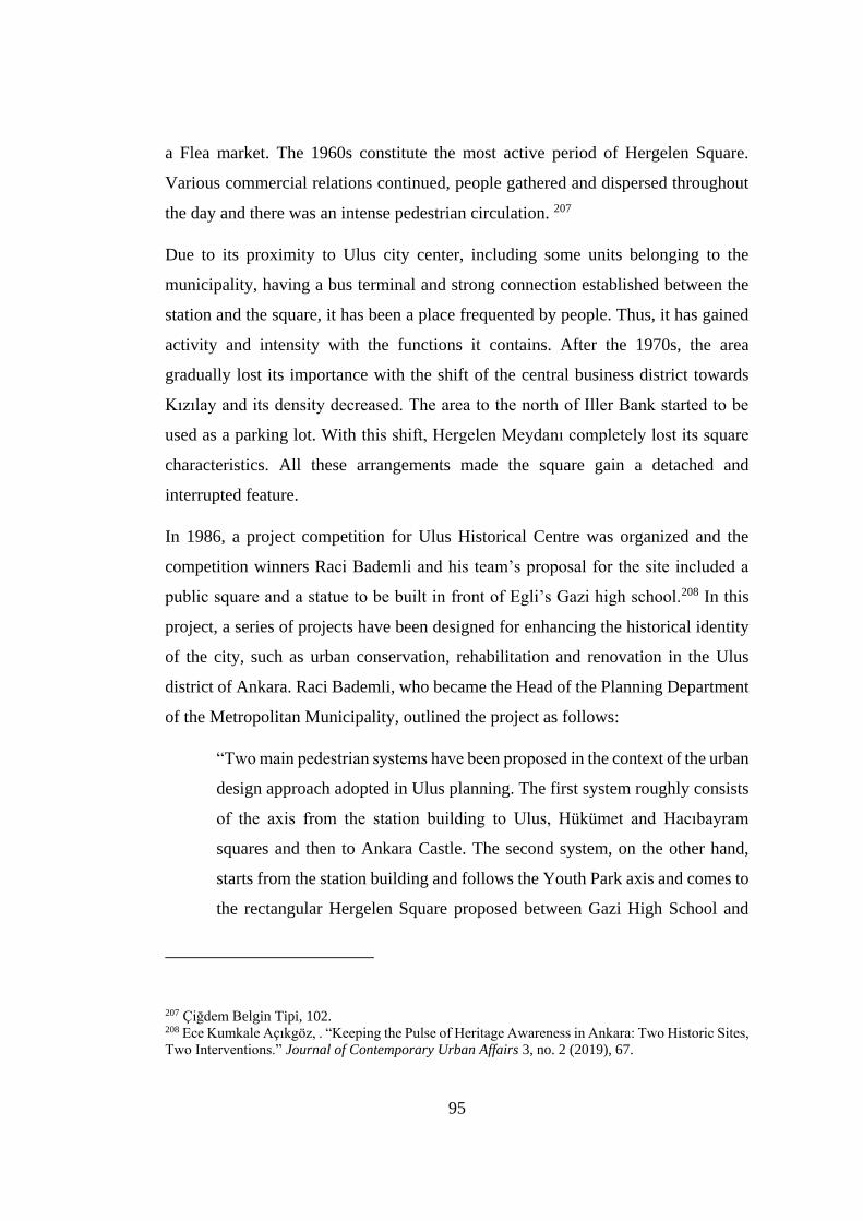
95
a Flea market. The 1960s constitute the most active period of Hergelen Square.
Various commercial relations continued, people gathered and dispersed throughout
the day and there was an intense pedestrian circulation. 207
Due to its proximity to Ulus city center, including some units belonging to the
municipality, having a bus terminal and strong connection established between the
station and the square, it has been a place frequented by people. Thus, it has gained
activity and intensity with the functions it contains. After the 1970s, the area
gradually lost its importance with the shift of the central business district towards
Kızılay and its density decreased. The area to the north of Iller Bank started to be
used as a parking lot. With this shift, Hergelen Meydanı completely lost its square
characteristics. All these arrangements made the square gain a detached and
interrupted feature.
In 1986, a project competition for Ulus Historical Centre was organized and the
competition winners Raci Bademli and his team’s proposal for the site included a
public square and a statue to be built in front of Egli’s Gazi high school.208 In this
project, a series of projects have been designed for enhancing the historical identity
of the city, such as urban conservation, rehabilitation and renovation in the Ulus
district of Ankara. Raci Bademli, who became the Head of the Planning Department
of the Metropolitan Municipality, outlined the project as follows:
“Two main pedestrian systems have been proposed in the context of the urban
design approach adopted in Ulus planning. The first system roughly consists
of the axis from the station building to Ulus, Hükümet and Hacıbayram
squares and then to Ankara Castle. The second system, on the other hand,
starts from the station building and follows the Youth Park axis and comes to
the rectangular Hergelen Square proposed between Gazi High School and
207 Çiğdem Belgin Tipi, 102. 208 Ece Kumkale Açıkgöz, . “Keeping the Pulse of Heritage Awareness in Ankara: Two Historic Sites,
Two Interventions.” Journal of Contemporary Urban Affairs 3, no. 2 (2019), 67.
96
Atatürk Boulevard. Later, it leaves the square and reaches Kale via
Samanpazarı.”209
Figure 4.11. The second pedestrian system that Raci Bademli proposed. (Source:
Google Maps, Edited by author.)
One of the important contributions of the plan was the sculpture to be built in front
of Gazi High School. There were two squares, one fully open, one covered with trees,
and a triangular area again was to be afforested as envisioned for the area in front of
Gazi High School. The SANART Organization, the German Cultural Association
and the German Embassy applied to the Metropolitan Municipality for the
internationally renowned artist Otto Herbert Hajek to commission a sculpture for
Ankara, thinking that it would be a cultural gain for the city. 210 For that purpose, the
square in front the high school was allocated for Otto Herbert Hajek’s sculpture. In
the other square and triangular area, there were trees for landscaping. The Hergelen
Meydan project of Hajek could not be fully completed with applications contrary to
the "Ulus Historical City Plan" project. In addition, sculpture has become useless
due to neglect. The sculpture of Otto Herbert Hajek will be examined in another
209 Raci Bademli, “Hergelen Meydanı.” Essay. In Ankara söyleşileri: Kasım-Aralık 1993, edited by
Çimen Bayar, 7–11 (Ankara: TMMOB Mimarlar Odası Ankara Şubesi, 1993), 8. 210 Raci Bademli, 10, 11.

97
section of the chapter because at that time, specific significance was attributed to the
sculpture for the square. Ece Kumkale Açıkgöz interpreted that Hajek’s sculpture
was not suitable for this particular area with following words; “The Square was used
as car park for decades while the sculpture neighbored an informal market where the
second hand goods were sold. This is why Hajek’s sculpture could not be a part of
an urban integrity.”211 However, still there was an attempt for a cultural integration
with the sculpture. According to Raci Bademli, as pointed above, the axis along the
train station, the Youth Park, Hergelen Square, Hajek’s Sculpture, Gazi High School
and Ankara castle was a strong visual attention. In that manner, the attempt of
cultural integration via sculpture had an immense role.
Some other decisions taken for the area in Ulus Historical City Plan are as follows:
Removal of the bus parking area and stops in the north of Hergelen Square,
Conversion of Gazi High School in the east of the square into Gazi Cultural
Facility,
In order to define the square and to make it functional, a part of the area in
the north and south of the square is reserved as "Municipal Rent Facilities"
and "Hotel Place" for cultural and tourism purposes, respectively, and the
area below these uses as "City Bazaar" and "Parking lot".
Expropriation of private parcels in the west of Gazi High School and
demolition of the buildings in the parcels.212
Among these decisions, only the parcels in front of Gazi High School were
expropriated and the buildings in these parcels were demolished. Other decisions
could not be implemented. Then the empty parcels were allocated for Hajek’s
sculpture, as stated before.
211 Ece Kumkale Açıkgöz, 67. 212 Çiğdem Belgin Tipi, 102.

98
Figure 4.12. Aerial View of Hergelen Square and Hajek’s Project on the west side
of Gazi High School. The large amount of the square was used as parking lot.
(Source: Çiğdem Belgin Tipi, “Hergelen Meydanı Çevre Düzenleme ve Korumasına
İişkin Öneriler, 204.)
The expropriated parcels consisted of convex and single row parcels towards Gazi
High School. As reported by Raci Bademli:
“We have come to the opinion that these parcels, which have survived to the
present day with a few four-storey buildings built in the 1940-60 period, is
not a piece of tissue that is worth giving data to the design of Hergelen
Square. We decided that it would be a more consistent approach to reveal the
registered Gazi High School building by eliminating this building block.”213
213 Raci Bademli, 8.
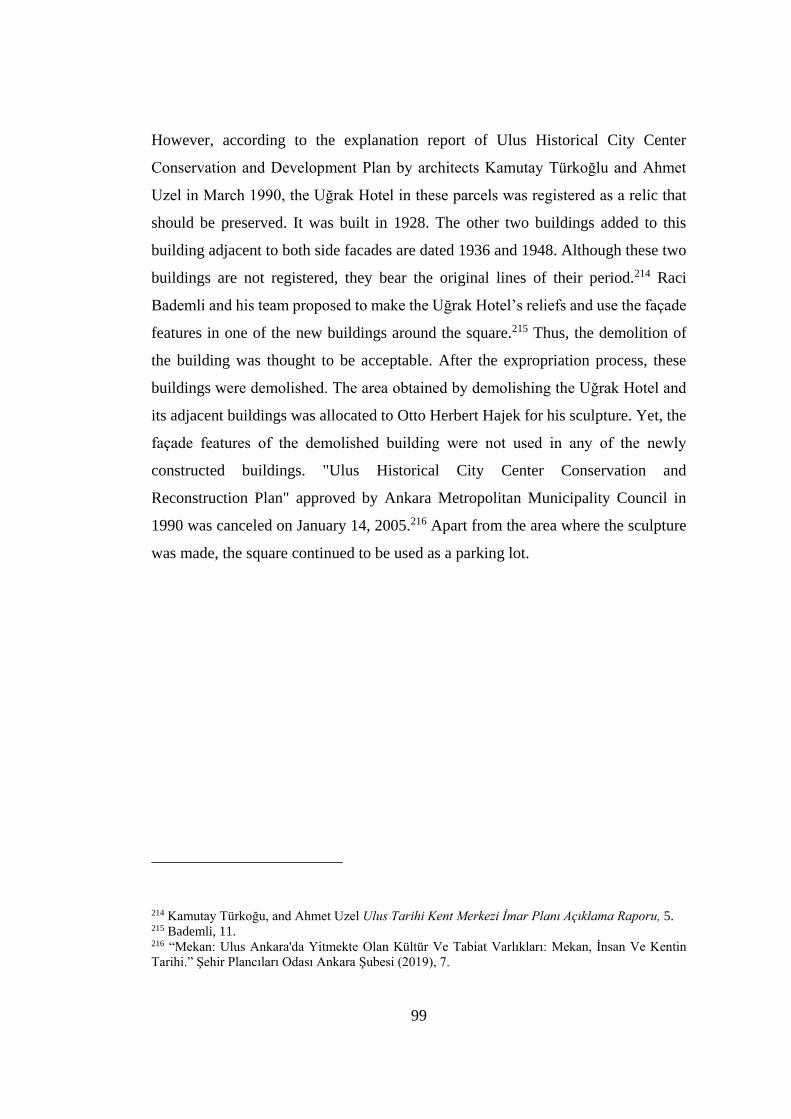
99
However, according to the explanation report of Ulus Historical City Center
Conservation and Development Plan by architects Kamutay Türkoğlu and Ahmet
Uzel in March 1990, the Uğrak Hotel in these parcels was registered as a relic that
should be preserved. It was built in 1928. The other two buildings added to this
building adjacent to both side facades are dated 1936 and 1948. Although these two
buildings are not registered, they bear the original lines of their period.214 Raci
Bademli and his team proposed to make the Uğrak Hotel’s reliefs and use the façade
features in one of the new buildings around the square.215 Thus, the demolition of
the building was thought to be acceptable. After the expropriation process, these
buildings were demolished. The area obtained by demolishing the Uğrak Hotel and
its adjacent buildings was allocated to Otto Herbert Hajek for his sculpture. Yet, the
façade features of the demolished building were not used in any of the newly
constructed buildings. "Ulus Historical City Center Conservation and
Reconstruction Plan" approved by Ankara Metropolitan Municipality Council in
1990 was canceled on January 14, 2005.216 Apart from the area where the sculpture
was made, the square continued to be used as a parking lot.
214 Kamutay Türkoğu, and Ahmet Uzel Ulus Tarihi Kent Merkezi Imar Planı Acıklama Raporu, 5. 215 Bademli, 11. 216 “Mekan: Ulus Ankara'da Yitmekte Olan Kültür Ve Tabiat Varlıkları: Mekan, İnsan Ve Kentin
Tarihi.” Şehir Plancıları Odası Ankara Şubesi (2019), 7.
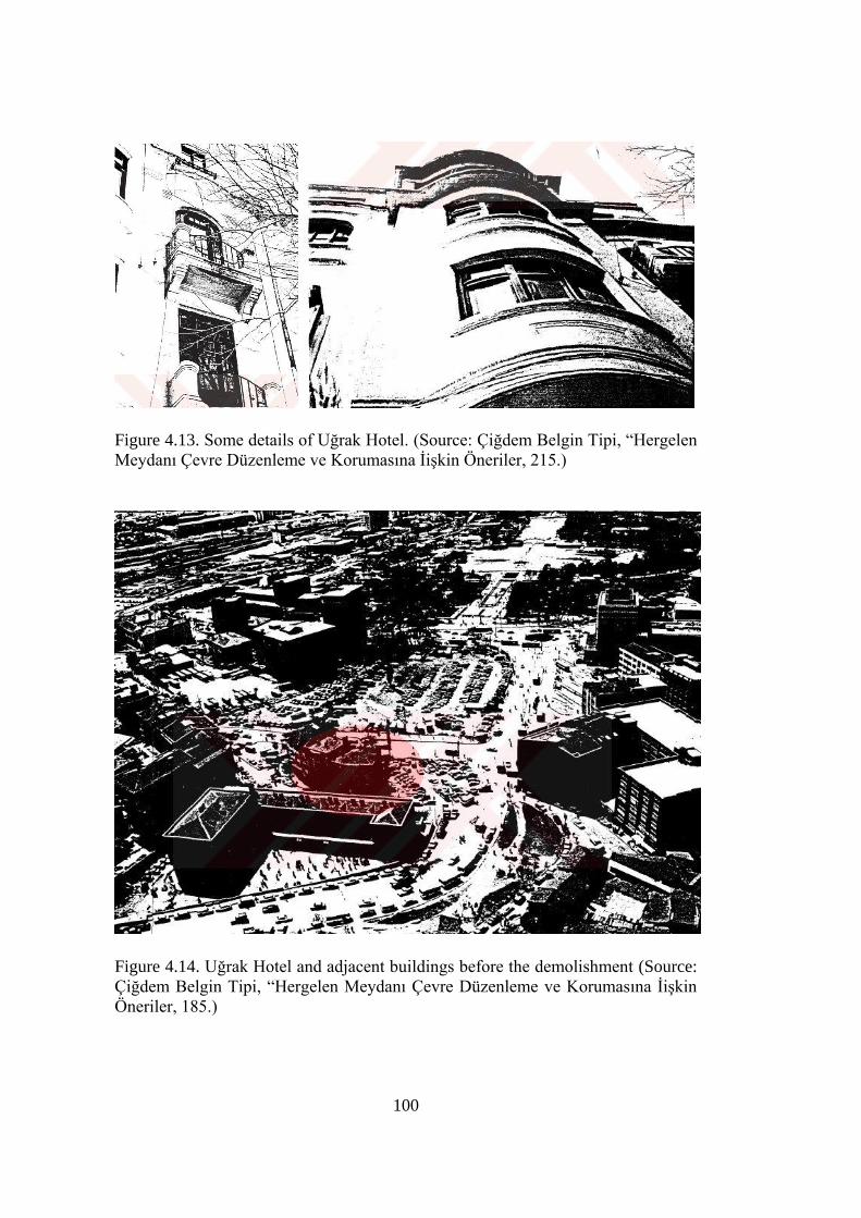
100
Figure 4.13. Some details of Uğrak Hotel. (Source: Çiğdem Belgin Tipi, “Hergelen
Meydanı Çevre Düzenleme ve Korumasına İişkin Öneriler, 215.)
Figure 4.14. Uğrak Hotel and adjacent buildings before the demolishment (Source:
Çiğdem Belgin Tipi, “Hergelen Meydanı Çevre Düzenleme ve Korumasına İişkin
Öneriler, 185.)
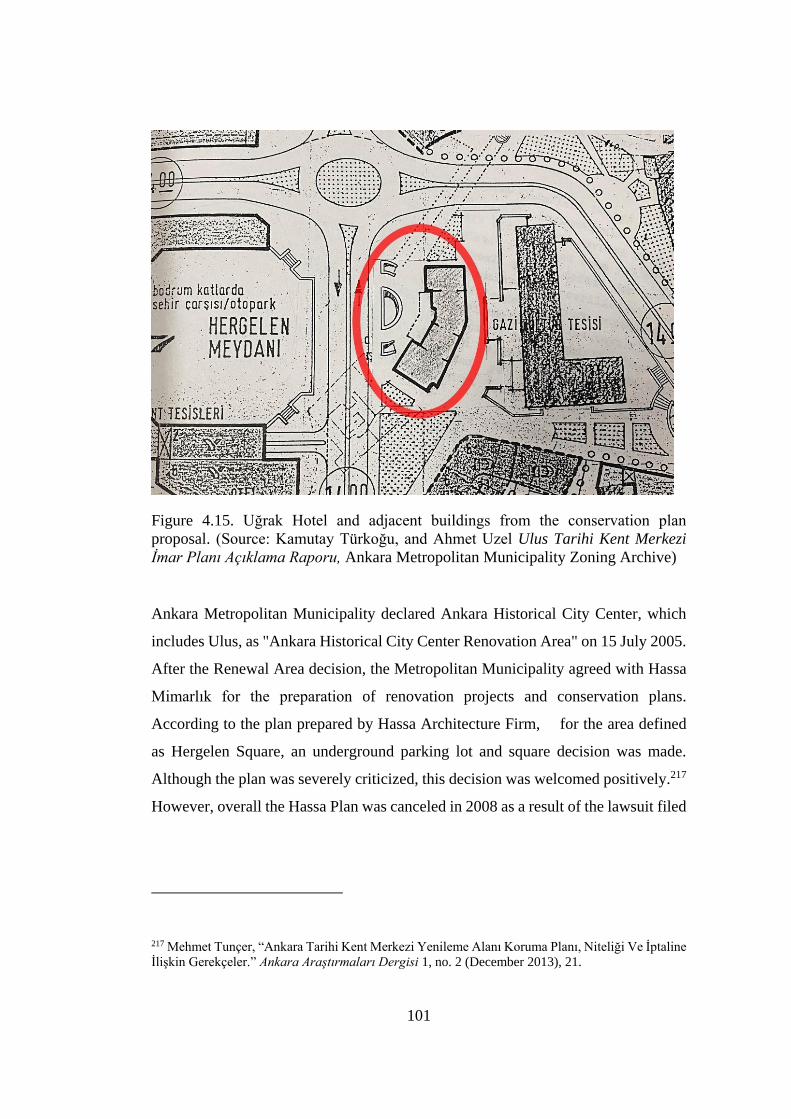
101
Figure 4.15. Uğrak Hotel and adjacent buildings from the conservation plan
proposal. (Source: Kamutay Türkoğu, and Ahmet Uzel Ulus Tarihi Kent Merkezi
Imar Planı Acıklama Raporu, Ankara Metropolitan Municipality Zoning Archive)
Ankara Metropolitan Municipality declared Ankara Historical City Center, which
includes Ulus, as "Ankara Historical City Center Renovation Area" on 15 July 2005.
After the Renewal Area decision, the Metropolitan Municipality agreed with Hassa
Mimarlık for the preparation of renovation projects and conservation plans.
According to the plan prepared by Hassa Architecture Firm, for the area defined
as Hergelen Square, an underground parking lot and square decision was made.
Although the plan was severely criticized, this decision was welcomed positively.217
However, overall the Hassa Plan was canceled in 2008 as a result of the lawsuit filed
217 Mehmet Tunçer, “Ankara Tarihi Kent Merkezi Yenileme Alanı Koruma Planı, Niteliği Ve İptaline
İlişkin Gerekçeler.” Ankara Araştırmaları Dergisi 1, no. 2 (December 2013), 21.
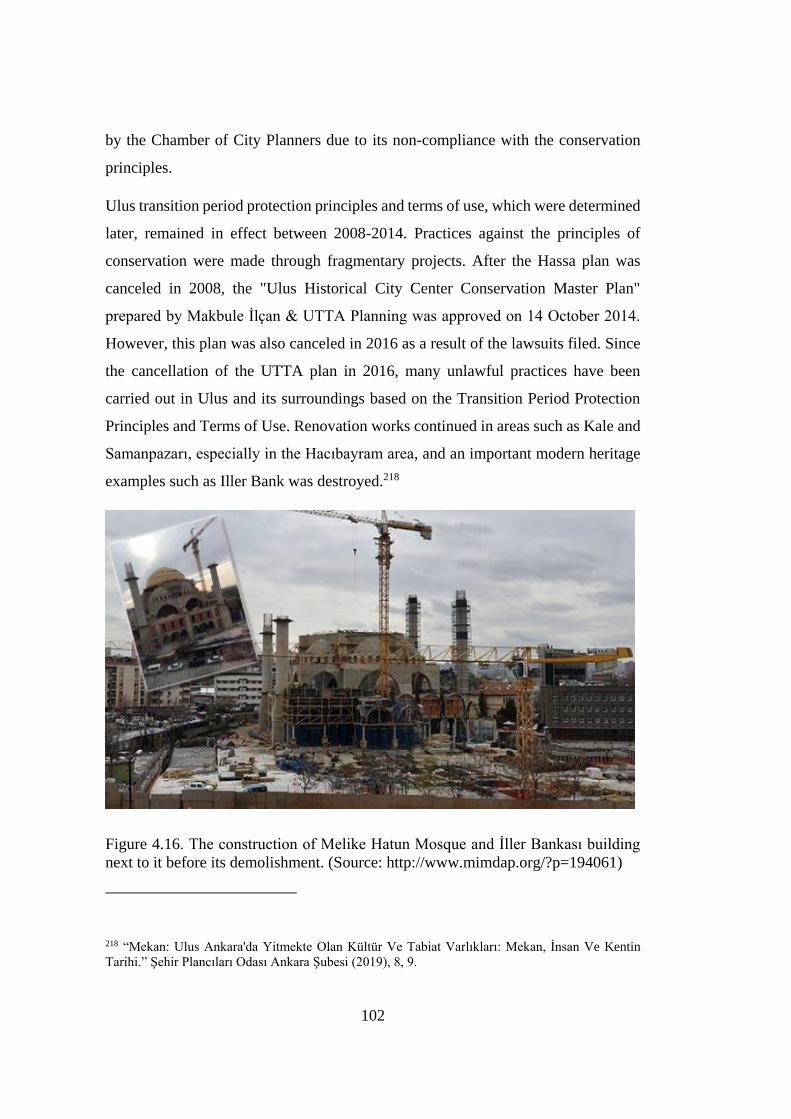
102
by the Chamber of City Planners due to its non-compliance with the conservation
principles.
Ulus transition period protection principles and terms of use, which were determined
later, remained in effect between 2008-2014. Practices against the principles of
conservation were made through fragmentary projects. After the Hassa plan was
canceled in 2008, the "Ulus Historical City Center Conservation Master Plan"
prepared by Makbule İlçan & UTTA Planning was approved on 14 October 2014.
However, this plan was also canceled in 2016 as a result of the lawsuits filed. Since
the cancellation of the UTTA plan in 2016, many unlawful practices have been
carried out in Ulus and its surroundings based on the Transition Period Protection
Principles and Terms of Use. Renovation works continued in areas such as Kale and
Samanpazarı, especially in the Hacıbayram area, and an important modern heritage
examples such as Iller Bank was destroyed.218
Figure 4.16. The construction of Melike Hatun Mosque and İller Bankası building
next to it before its demolishment. (Source: http://www.mimdap.org/?p=194061)
218 “Mekan: Ulus Ankara'da Yitmekte Olan Kültür Ve Tabiat Varlıkları: Mekan, İnsan Ve Kentin
Tarihi.” Şehir Plancıları Odası Ankara Şubesi (2019), 8, 9.
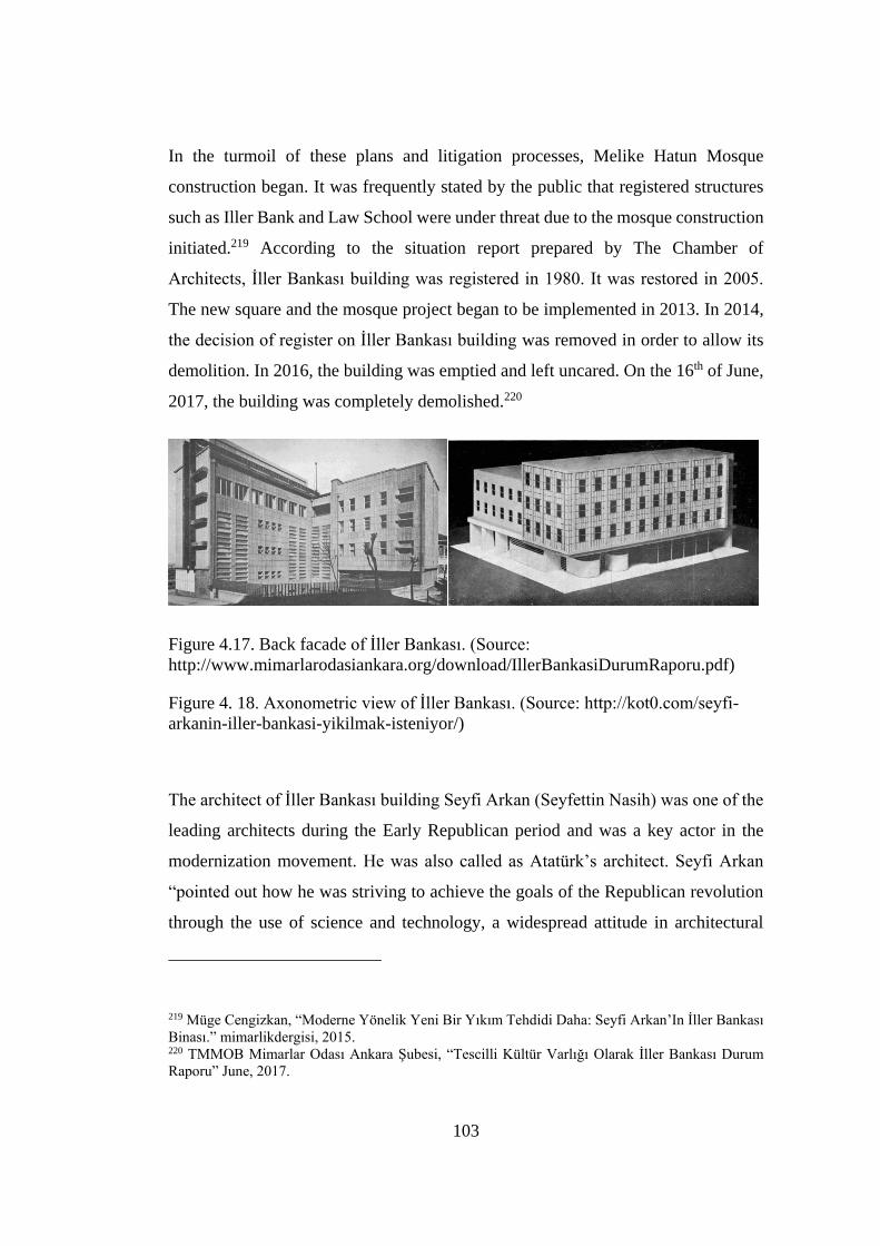
103
In the turmoil of these plans and litigation processes, Melike Hatun Mosque
construction began. It was frequently stated by the public that registered structures
such as Iller Bank and Law School were under threat due to the mosque construction
initiated.219 According to the situation report prepared by The Chamber of
Architects, İller Bankası building was registered in 1980. It was restored in 2005.
The new square and the mosque project began to be implemented in 2013. In 2014,
the decision of register on İller Bankası building was removed in order to allow its
demolition. In 2016, the building was emptied and left uncared. On the 16th of June,
2017, the building was completely demolished.220
Figure 4.17. Back facade of İller Bankası. (Source:
http://www.mimarlarodasiankara.org/download/IllerBankasiDurumRaporu.pdf)
Figure 4. 18. Axonometric view of İller Bankası. (Source: http://kot0.com/seyfi-
arkanin-iller-bankasi-yikilmak-isteniyor/)
The architect of İller Bankası building Seyfi Arkan (Seyfettin Nasih) was one of the
leading architects during the Early Republican period and was a key actor in the
modernization movement. He was also called as Atatürk’s architect. Seyfi Arkan
“pointed out how he was striving to achieve the goals of the Republican revolution
through the use of science and technology, a widespread attitude in architectural
219 Müge Cengizkan, “Moderne Yönelik Yeni Bir Yıkım Tehdidi Daha: Seyfi Arkan’In İller Bankası
Binası.” mimarlikdergisi, 2015. 220 TMMOB Mimarlar Odası Ankara Şubesi, “Tescilli Kültür Varlığı Olarak İller Bankası Durum
Raporu” June, 2017.
104
circles at the time.”221 His mission also indicates that he was truly a modernist
architect at his time.
The building had an extensive place for Turkish architects among the structures built
in the Early Republic period. According to Yasemin Gürel, İller Bankası building
was ultimately modest and moderate in modern approach.222 Opera Building which
was proposed in Jansen plan was across the Youth Park and next to İller Bankası
building. In order not to shadow the importance of the Opera House, Seyfi Arkan
deliberately chose to use simple language in his design. The building, which uniquely
combined the simplicity of expression and design, was an instructive example of
Arkan's modernist approach. In the interview with Muharrem Hilmi Şenalp, the
architect of the mosque, he stated that İller Bankası should have been protected. And
he continued: “According to the understanding of that period, it had a proper design
with the use of materials and architectural understanding. That's why it had to be
protected. I also said that it should be conserved. The Board [of Conservation of
Cultural Assets] decided to demolish it and to build the same building to another
corner of the same land. However, they did not.”223 This specially designed structure
belonging to İller Bankası (the Bank of Municipalities), which played an important
role in the technical development of the provinces of Turkey, was demolished as a
result of an unfortunate decision. The area partly obtained of İller Bankası was used
for the mosque construction and square arrangement. Today, there is only Melike
Hatun Mosque on the square and there are a car park, a shopping center and
exhibition areas under the square.
221 Yıldız Sey, “To House The New Citizens: Housing Policies and Mass Housing” in Modern Turkish
Architecture, ed. Renata Holod, Ahmet Evin and Suha Özkan (Chamber of Architects: Ankara, 2005),
165. 222 Yasemin Gürel, “Seyfi Arkan: Bir Erken Modernist” in Modernist Acılımda Bir Öncü Seyfi Arkan,
ed. Ali Cengizkan, A. Derin İnan and N. Müge Cengizkan (Mimarlar Odası Yayınları: Ankara, 2012),
40. 223 Muharrem Hilmi Şenalp, Interview by the author. Personal interview, İstanbul, June 10, 2021.

105
Figure 4.19. The demolishment of İller Bankası (Source:
http://www.mimarlarodasiankara.org/download/IllerBankasiDurumRaporu.pdf)
4.2.3 Socio-cultural Use of Hergelen Square
Hergelen Square’s function and density has changed many times from the beginning
of the 20th century until today. Taking into account its location in the city, it is clear
how important the square is for the city and its inhabitants to bring it to the city by
reorganizing it. While it was an area where cattle roamed, it became the critical point
of one of the two important axes of the planned city. “Hergelen Square had always
contributed to cultural accumulation; it had always been more than a mere open
space, it came to being as a social institution rooted back in ancient times.
Accordingly, Hergelen Square was a significant gathering place where important
celebrations, meetings and rituals took stage.”224 For a while, it was one of Ankara's
first haunts. The first stop of those who migrated to Ankara from neighboring
224 Emre Demirel, “The Haptic and Visual Considerations of Public Spaces: Otto Herbert Hajek’s
Proposal for Hergelen Square in Ankara.” Online Journal of Art and Design 7, no. 1 (January 2019),
207.
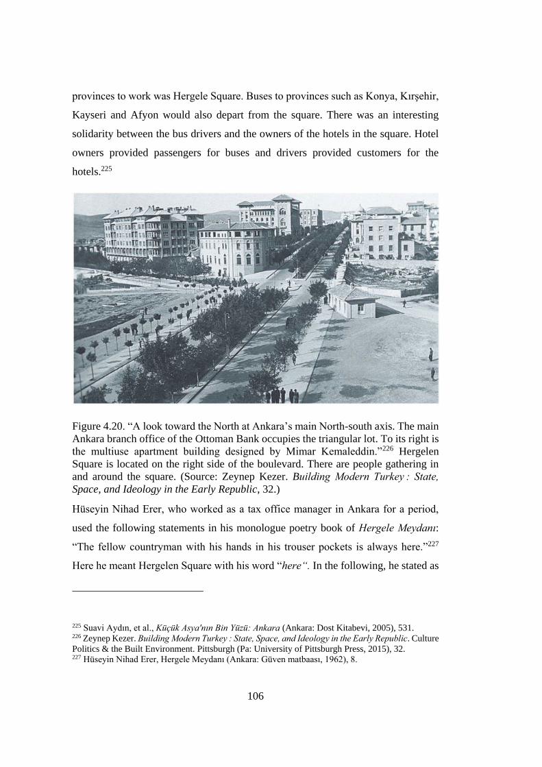
106
provinces to work was Hergele Square. Buses to provinces such as Konya, Kırşehir,
Kayseri and Afyon would also depart from the square. There was an interesting
solidarity between the bus drivers and the owners of the hotels in the square. Hotel
owners provided passengers for buses and drivers provided customers for the
hotels.225
Figure 4.20. “A look toward the North at Ankara’s main North-south axis. The main
Ankara branch office of the Ottoman Bank occupies the triangular lot. To its right is
the multiuse apartment building designed by Mimar Kemaleddin.”226 Hergelen
Square is located on the right side of the boulevard. There are people gathering in
and around the square. (Source: Zeynep Kezer. Building Modern Turkey : State,
Space, and Ideology in the Early Republic, 32.)
Hüseyin Nihad Erer, who worked as a tax office manager in Ankara for a period,
used the following statements in his monologue poetry book of Hergele Meydanı:
“The fellow countryman with his hands in his trouser pockets is always here.”227
Here he meant Hergelen Square with his word “here“. In the following, he stated as
225 Suavi Aydın, et al., Kücük Asya'nın Bin Yüzü: Ankara (Ankara: Dost Kitabevi, 2005), 531. 226 Zeynep Kezer. Building Modern Turkey : State, Space, and Ideology in the Early Republic. Culture
Politics & the Built Environment. Pittsburgh (Pa: University of Pittsburgh Press, 2015), 32. 227 Hüseyin Nihad Erer, Hergele Meydanı (Ankara: Güven matbaası, 1962), 8.
107
follows: “Tonight the black train brought the party members to the Hergele Square
… Party members from the four corners of the country to the big congress. I don't
know which political party is.”228 It is understood from here that there is an easily
accessible link between the train station and Hergelen Square. If this connection is
understood even in 1962, when the book was written, Hergelen Square, located on
the axis of the Station – Castle, emphasized by Raci Bademli, is even more critical.
It is understood from Erer's book that there is an active circulation of people in the
square in general. Although the author complains that the square is neglected and
muddy, the square is in the daily lives of the city dwellers.
Since the planned arrangements for the square were not realized, the square, which
was used as a parking lot, lost its pedestrian crossing point feature mentioned above.
With the sculpture designed and made in the area allocated to Otto Herbert Hajek by
Raci Bademli and his team, it was aimed to revive the square from a sociocultural
perspective.
4.2.3.1 Otto Herbert Hajek’s Sculpture in Hergelen Square
Previously stated that a part of the area that emerged with the demolition of the
buildings in front of Gazi High School was allocated to Otto Hajek. The main aim
of Raci Bademli and his team about the demolishment of buildings was to expose
the architecture of Gazi High School desgined by Ernst A. Egli. Bademli states that
if the sculpture was done successfully, Egli's work would be revealed, and another
German would have made a sculpture right in front of it after a break of 50-60
years.229 And the critical axis between train station and castle along with Hergelen
Square would be much more distinct.
228 Hüseyin Nihad Erer, 36. 229 Raci Bademli, “Hergelen Meydanı.” Essay. In Ankara söyleşileri: Kasım-Aralık 1993, edited by
Çimen Bayar, 7–11 (Ankara: TMMOB Mimarlar Odası Ankara Şubesi, 1993), 11.
108
Otto Herbert Hajek was an artist who was known with his abstract paintings and
sculptures. His works mainly based on geometrical combinations of heavy materials
with primary colour details.230 He designed over 40 architectural spaces in various
cities including Frankfurt, Wiesbaden, Stuttgart, Munich, Bonn, Heidelberg, Mainz
and Ankara. The issue of the freedom of art and the independence of the artist from
politics constitute a crucial part of Hajek's work.231 Hajek's works interpret the
dialogue of art with society through the urban environment by integrating sculpture
and architecture. Artist; “My workshop is where I work. My travel destination within
my workshop can be a street, a square, a neighborhood. It is such a workshop that it
is a workshop of works and being influenced” and expresses the importance of the
environmental in his works. Hajek explains the nature of art, emphasizing the
dialectic of artistic and social space, in a triple development chain that is "nature-
nature", "art-nature" and "social-nature".232 The artist, who sees colors as a style that
determines movement and direction in his works in public spaces, aims to increase
the spatial effect with the colors that characterize him frequently (blue, red, yellow,
sometimes white and gray, silver and gold, orange and earth yellow). And with this
increasing effect, he aims to establish relationships with the people who live in that
space. The determination of his works, which create an alarm effect in the urban
centers that have lost their identity, creates and activates a political force in the
society. In this sense, Hajek's works undertake public duties in urban living spaces.233
Spatial and urban symbols of his works enable individuals to participate in aesthetic
experience in everyday life. With this aesthetic experience, the individual redefines
the surrounding environment with a creative process.
Hajek planned to realize the above-mentioned purposes in his sculpture, which he
designed in Ankara. He also aimed to include the society in the artistic process in the
230 “Otto Herbert Hajek.” Santa & Cole, November 30, 2020. 231 Sevna Aygün, “Otto Herbert Hajek Hergelen Meydanı Çevre Düzenlemesi Ulus”, 80. 232 Mustafa Sevinç, “Bir Hafıza Mekanı Olarak Kent Meydanı Ve Dönüşümü: Otto Herbert Hajek’in
Ankara Hergelen Meydan Projesi Örneği.”, 57. 233 Sevna Aygün, “Otto Herbert Hajek Hergelen Meydanı Çevre Düzenlemesi Ulus”, 81.
109
space it was designed for. Prof. Hajek perceives the Gazi High School, which is
behind the square in his project, as a wall. It aims to draw the castle seen from afar
to the center of the city.234 In the square, Hajek sees orientation in the composition
of cones and cylinders; basic forms express freedom and color. Water and light
games also bring movement to the new formation. Vivid colors are also reflective
colors. In the daytime, the sun and clouds will be reflected in colors. Thus, daily life
will be seen in colors. The signs in the square target the school both with their colors
and sizes. For this reason, the school's color is changed to yellow.235 Bayar Çimen
commented on the sculpture with following words:
While the Gazi High School to be painted emphasizes joy, liveliness and life
with its yellow color, the castle and Ankara stone that remain in the distance
will descend down into the green. Yellow color is more durable than other
basic colors and will bring a permanent new definition to the city. Hajek
wanted to add the sun and the yellow color to the space-light-shadow
relations that are desired to be achieved in the square. The yellow color would
once again shine under the influence of the sun and emphasize “the vitality
of orientalism.” And thus, a new step would be taken for the improvement of
Ankara. The school entrance was highlighted by a column painted in red.
Hergelen Square and Hajek Sculpture would be the sign of the city of Ankara
in the future. The trees that filled the square and triangle areas on both sides
of Hergelen Square reflected the nature / nature relationship; Prof. Hajek's
colorful sculpture expresses artistic nature.236
234 Bayar Çimen, “Hajek Meydanı.” Essay. In Ankara söyleşileri: Kasım-Aralık 1993, edited by
Çimen Bayar, 12 (Ankara: TMMOB Mimarlar Odası Ankara Şubesi, 1993), 12. 235 Bayar Çimen, “Ankara'nın Yeni Meydanları.” Mimarlık no. 250, 1992, 13. 236 Bayar Çimen, “Kentsel ve Mimari Mekanda Sanat Hergelen Meydanı Otto Herbert Hajek.”
Mimarlık no. 256, 1994, 65.
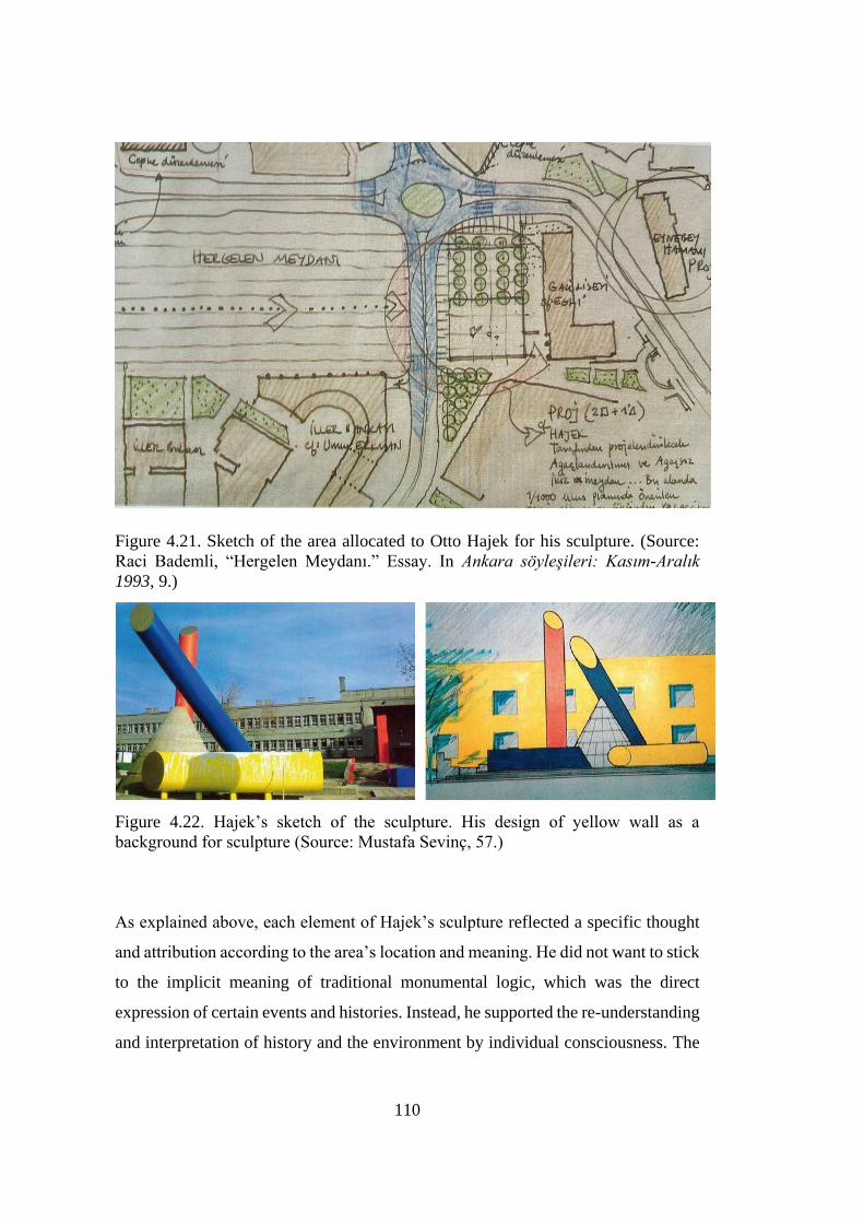
110
Figure 4.21. Sketch of the area allocated to Otto Hajek for his sculpture. (Source: Raci Bademli, “Hergelen Meydanı.” Essay. In Ankara söyleşileri: Kasım-Aralık
1993, 9.)
Figure 4.22. Hajek’s sketch of the sculpture. His design of yellow wall as a
background for sculpture (Source: Mustafa Sevinç, 57.)
As explained above, each element of Hajek’s sculpture reflected a specific thought
and attribution according to the area’s location and meaning. He did not want to stick
to the implicit meaning of traditional monumental logic, which was the direct
expression of certain events and histories. Instead, he supported the re-understanding
and interpretation of history and the environment by individual consciousness. The
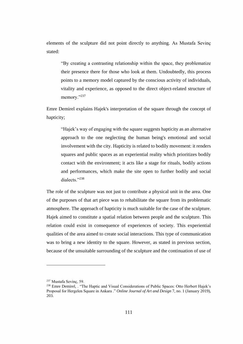
111
elements of the sculpture did not point directly to anything. As Mustafa Sevinç
stated:
“By creating a contrasting relationship within the space, they problematize
their presence there for those who look at them. Undoubtedly, this process
points to a memory model captured by the conscious activity of individuals,
vitality and experience, as opposed to the direct object-related structure of
memory.”237
Emre Demirel explains Hajek's interpretation of the square through the concept of
hapticity;
“Hajek’s way of engaging with the square suggests hapticity as an alternative
approach to the one neglecting the human being's emotional and social
involvement with the city. Hapticity is related to bodily movement: it renders
squares and public spaces as an experiential reality which prioritizes bodily
contact with the environment; it acts like a stage for rituals, bodily actions
and performances, which make the site open to further bodily and social
dialects.”238
The role of the sculpture was not just to contribute a physical unit in the area. One
of the purposes of that art piece was to rehabilitate the square from its problematic
atmosphere. The approach of hapticity is much suitable for the case of the sculpture.
Hajek aimed to constitute a spatial relation between people and the sculpture. This
relation could exist in consequence of experiences of society. This experiential
qualities of the area aimed to create social interactions. This type of communication
was to bring a new identity to the square. However, as stated in previous section,
because of the unsuitable surrounding of the sculpture and the continuation of use of
237 Mustafa Sevinç, 59. 238 Emre Demirel, . “The Haptic and Visual Considerations of Public Spaces: Otto Herbert Hajek’s
Proposal for Hergelen Square in Ankara .” Online Journal of Art and Design 7, no. 1 (January 2019),
203.
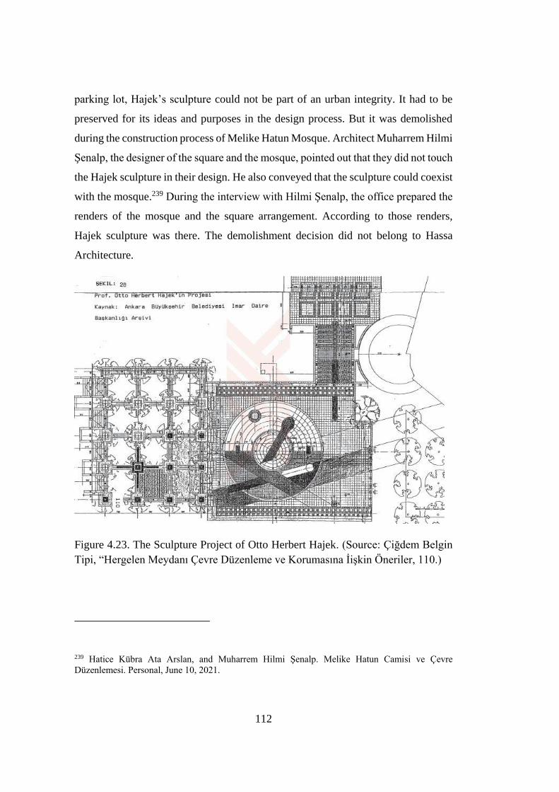
112
parking lot, Hajek’s sculpture could not be part of an urban integrity. It had to be
preserved for its ideas and purposes in the design process. But it was demolished
during the construction process of Melike Hatun Mosque. Architect Muharrem Hilmi
Şenalp, the designer of the square and the mosque, pointed out that they did not touch
the Hajek sculpture in their design. He also conveyed that the sculpture could coexist
with the mosque.239 During the interview with Hilmi Şenalp, the office prepared the
renders of the mosque and the square arrangement. According to those renders,
Hajek sculpture was there. The demolishment decision did not belong to Hassa
Architecture.
Figure 4.23. The Sculpture Project of Otto Herbert Hajek. (Source: Çiğdem Belgin
Tipi, “Hergelen Meydanı Çevre Düzenleme ve Korumasına İişkin Öneriler, 110.)
239 Hatice Kübra Ata Arslan, and Muharrem Hilmi Şenalp. Melike Hatun Camisi ve Çevre
Düzenlemesi. Personal, June 10, 2021.
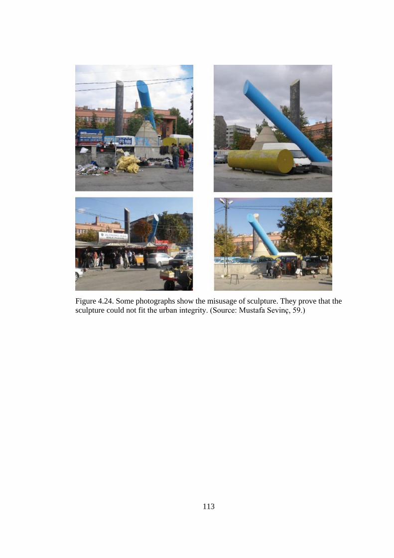
113
Figure 4.24. Some photographs show the misusage of sculpture. They prove that the
sculpture could not fit the urban integrity. (Source: Mustafa Sevinç, 59.)
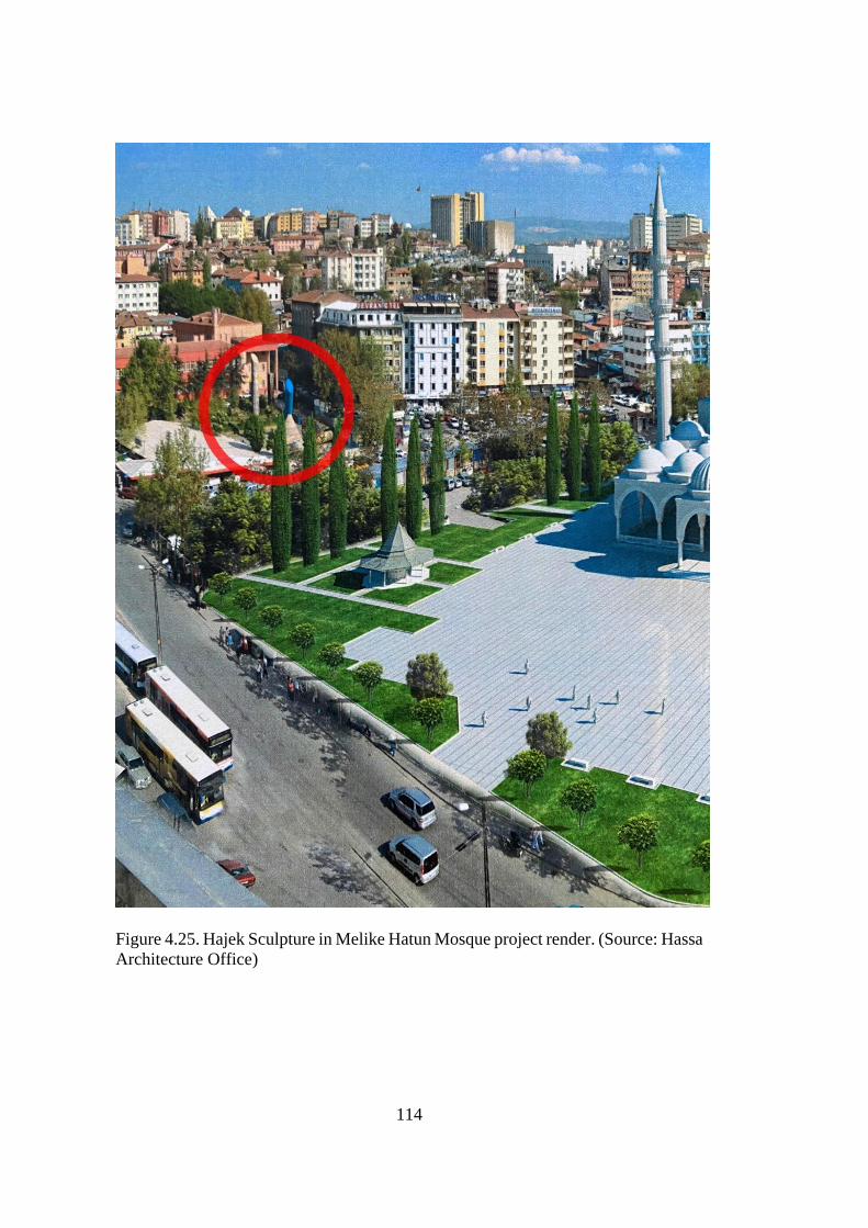
114
Figure 4.25. Hajek Sculpture in Melike Hatun Mosque project render. (Source: Hassa
Architecture Office)
115
4.3 Melike Hatun Mosque and Hergelen Square
According to the latest arrangements, there was a mosque planned to be built for the
square. In addition to the mosque, there was also a rehabilitation intended for the
area. Melike Hatun Mosque, which started to be built in 2013, was completed in
2017. It looks like the 16th century Ottoman mosques with its architectural style. In
addition, the scale of the mosque has a quite dominating character and scale. The
reason of selection in the style and the size of the structure would probably be related
with political power of the current governmental perspective. There is an attempt to
change the identity of the region and as a consequence, the place memory also altered
with this huge structure. In this section, the mosque will be analyzed with regards to
architectural mimicry of Ottoman mosques. Because the buildings around the square
were designed in a particular way to define the square and its surroundings as a new
allocation for the new Republic. This specific environment is marked by the scale
and architectural style of the mew mosque. Analyzing the architecture of the mosque
helps to examine the change in the memory of the place. Depending on this change,
the collective memory related with the place was also affected.
Before examining the architecture of the mosque, it is necessary to present the
relationship between the mosque and the square and the location of the overall
design. It is previously stated that Hergelen Square is located at the intersection point
of two main axes of Ankara. One is Atatürk Boulevard, north-south axis, another is
the main east-west axis. Muharrem Hilmi Şenalp commented on the decision of the
location of Melike Hatun Mosque. He stated that: “In the first years of the Republic,
plans were made by foreign city planners. This is the plan of modernity. It destroyed
the old. We wanted to build it at the intersection of crossroads and at the end of the
protocol road axis, in the heart of Ankara.”240 From this statement of Hilmi Şenalp,
there is not information only about the location of the mosque, it is also understood
240 Muharrem Hilmi Şenalp, Interview by author. Personal interview, İstanbul, June 10, 2021.
116
that critical urban design decisions were made against the plans made during the
Republican period. Also this decision of bringing the old into the area is an issue of
collective memory and history. Şenalp criticizes the design of modernity in Early
Republican times. Designing an Ottoman style mosque is a postmodern approach to
re-establish our connection with the past. Christine Boyer criticizes postmodern
architecture with reference to Maurice Halbwachs as follows:
“Postmodern art and architecture assumed that images and artifacts bear the
record of the past; they either speak historical role or relay memories to
present. But history and memory, as Halbwachs accounted, are actually
opposing terms, the one manipulable and re-presentable in a play of lost
significance, while the other is plural, alive, and cannot be appropriated.”241
Melike Hatun Mosque has elements that highly remind the Ottoman past. This
historical role of the mosque shadows the collective memory of the citizens related
with the Early Republican features of the capital city. The square was characterized
by certain Republican buildings and public open spaces such as the Youth Park and
Atatürk Boulevard. These buildings and spaces defined the identity of the place and
marked the memory specific to the area. The recent intervention of building a new
mosque and the rearrangement of its surroundings has created a discontinuity in
collective memory. “History fixes the past in a uniform manner; drawing upon its
difference from the present, it then reorganizes and resuscitates collective memories
and popular imagery, freezing them in stereotypical forms.”242 The mosque
manipulates the place and represents itself having a mission to retrieve the missing
old in the area.
Classical mosque architecture usually has a courtyard. The courtyard functions as a
preparatory area for prayers and it also serves as gathering place for congregation.
241 M. Christine Boyer, “The City of Collective Memory, Its Historical Imagery and Architectural
Entertainments (Massachusetts: The MIT Press, 1994), 67. 242 Boyer, 67.
117
When the inside of the mosque is completely filled, it can also be used as a prayer
area. Especially during Friday prayers, the congregation moves to the courtyard area.
In classical mosque design, courtyards are generally surrounded by walls. Within the
courtyard, there is also an ablution fountain that also serves for cooling in hot
weathers. Ablution is a ritual of cleaning and purification performed before prayer.
“In traditional mosques, ablution fountains are generally seen as freestanding
structures, which are called şadırvan, mostly placed in the middle of the
courtyard.”243
In the design of Melike Hatun, there is not any closed courtyard. Hergelen Square,
which merges with the courtyard, actually functions as the courtyard of the mosque.
Hilmi Şenalp stressed this specific issue with following words: “We tried to pull the
mosque back in the area given to us and create a square in front of it. We did not
create a courtyard. There are porticoes at the entrance of the mosque, they are also
open to the outside.”244 Designing the courtyard as an open square itself is an issue
to be focused on in terms of urban design and collective memory. As explained
above, the courtyard also functions as a spare area during prayer times, depending
on the occupancy of the mosque. The extra courtyard area used for prayer is also
called son cemaat mahalli which means the last area that congregation uses for
prayer. Even the architectural style of Melike Hatun Mosque is classical, what Şenalp
suggested for the mosque about the courtyard actually does not fit the classical
mosque design. Designing and using the square like a mosque courtyard is also
against the publicity of the place. As the following photographs taken from during a
Friday prayer time show that in the center of Ankara, in Hergelen Square that is a
public space used by people from different worldviews, from different genders etc.,
is to be reserved to the community of prayers, in a way visible to all. In other words,
the religious space is merged with the public realm that surrounds it. However, it is
243 Özgür Ürey “Use Of Traditional Elements in Contemporary Mosque Architecture in Turkey” (M.
Sc. Diss., Middle East Technical University, 2010), 54. 244 Muharrem Hilmi Şenalp, Interview by author. Personal interview, İstanbul, June 10, 2021.
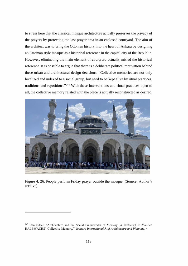
118
to stress here that the classical mosque architecture actually preserves the privacy of
the prayers by protecting the last prayer area in an enclosed courtyard. The aim of
the architect was to bring the Ottoman history into the heart of Ankara by designing
an Ottoman style mosque as a historical reference in the capital city of the Republic.
However, eliminating the main element of courtyard actually misled the historical
reference. It is possible to argue that there is a deliberate political motivation behind
these urban and architectural design decisions. “Collective memories are not only
localized and indexed to a social group, but need to be kept alive by ritual practices,
traditions and repetitions.”245 With these interventions and ritual practices open to
all, the collective memory related with the place is actually reconstructed as desired.
Figure 4. 26. People perform Friday prayer outside the mosque. (Source: Author’s
archive)
245 Can Bilsel, “Architecture and the Social Frameworks of Memory: A Postscript to Maurice
HALBWACHS' ‘Collective Memory.’” Iconarp International J. of Architecture and Planning, 4.
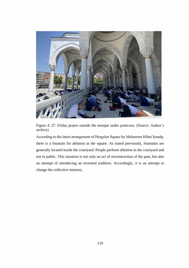
119
Figure 4. 27. Friday prayer outside the mosque under porticoes. (Source: Author’s
archive)
According to the latest arrangement of Hergelen Square by Muharrem Hilmi Şenalp,
there is a fountain for ablution in the square. As stated previously, fountains are
generally located inside the courtyard. People perform ablution in the courtyard and
not in public. This situation is not only an act of reconstruction of the past, but also
an attempt of introducing an invented tradition. Accordingly, it is an attempt to
change the collective memory.

120
Figure 4. 28. Ablution area in the square. (Source: https://www.trthaber.com/foto-
galeri/ankara-melike-hatun-camii/18511/sayfa-1.html)
At first sight the architectural style of the mosque recalls Ottoman style to minds.
While the mosque itself is debatable at a place that was characterized by architectural
styles that symbolized the Republican periods, the very resemblance of classical
Ottoman mosque brings up some questions in minds. There seems a deliberate
decision about choosing an Ottoman mimicked mosque. Here, it is not about an exact
replica of Ottoman mosques but there is an effort to keep the imperial image with a
certain resemblance to Ottoman mosques. Homi Bhabha defines the result of
mimicry as “almost the same but not quite.” Bülent Batuman explained this with
reference to colonized societies;
”Mimicry constantly troubles the colonizer’s authority by minimizing its
difference and simultaneously fails the colonized’s capacity for fully
assuming the identity of the colonizer. In a similar fashion, what is at stake
in the case of mimicking classical Ottoman mosque architecture is the desire
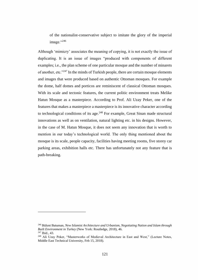
121
of the nationalist-conservative subject to imitate the glory of the imperial
image.“246
Although ‘mimicry’ associates the meaning of copying, it is not exactly the issue of
duplicating. It is an issue of images “produced with components of different
examples; i.e., the plan scheme of one particular mosque and the number of minarets
of another, etc.”247 In the minds of Turkish people, there are certain mosque elements
and images that were produced based on authentic Ottoman mosques. For example
the dome, half domes and porticos are reminiscent of classical Ottoman mosques.
With its scale and tectonic features, the current politic environment treats Melike
Hatun Mosque as a masterpiece. According to Prof. Ali Uzay Peker, one of the
features that makes a masterpiece a masterpiece is its innovative character according
to technological conditions of its age.248 For example, Great Sinan made structural
innovations as well as on ventilation, natural lighting etc. in his designs. However,
in the case of M. Hatun Mosque, it does not seem any innovation that is worth to
mention in our today’s technological world. The only thing mentioned about the
mosque is its scale, people capacity, facilities having meeting rooms, five storey car
parking areas, exhibition halls etc. There has unfortunately not any feature that is
path-breaking.
246 Bülent Batuman, New Islamist Architecture and Urbanism, Negotiating Nation and Islam through
Built Environment in Turkey (New York: Routledge, 2018), 46. 247 Ibid., 43. 248 Ali Uzay Peker, “Masterworks of Medieval Architecture in East and West,” (Lecture Notes,
Middle East Technical University, Feb 15, 2018).
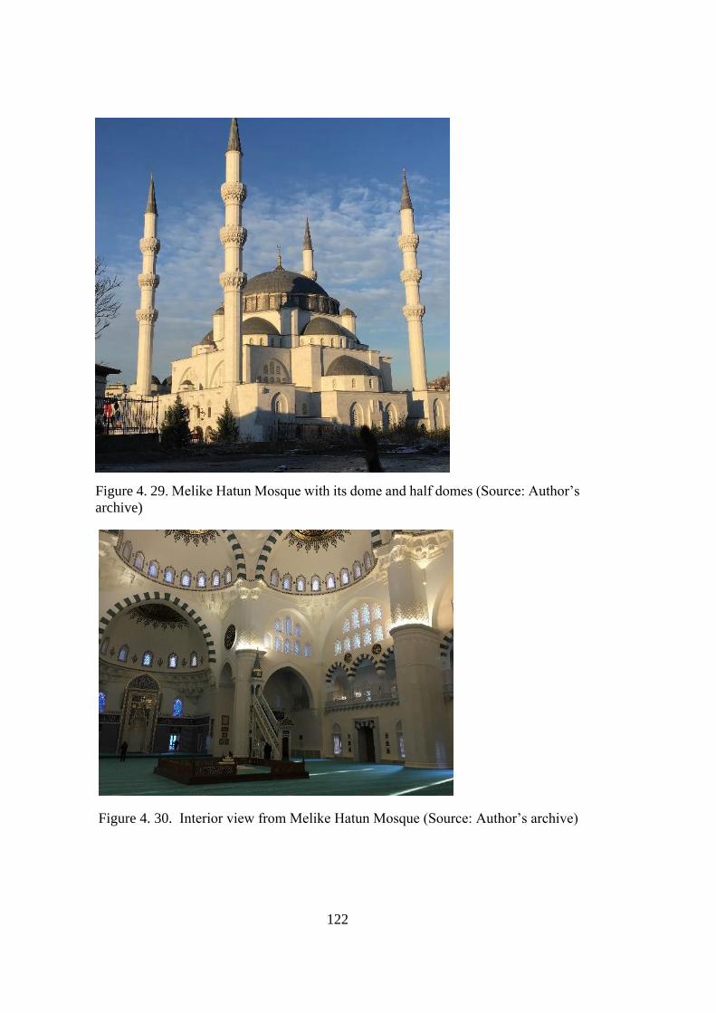
122
Figure 4. 29. Melike Hatun Mosque with its dome and half domes (Source: Author’s
archive)
Figure 4. 30. Interior view from Melike Hatun Mosque (Source: Author’s archive)
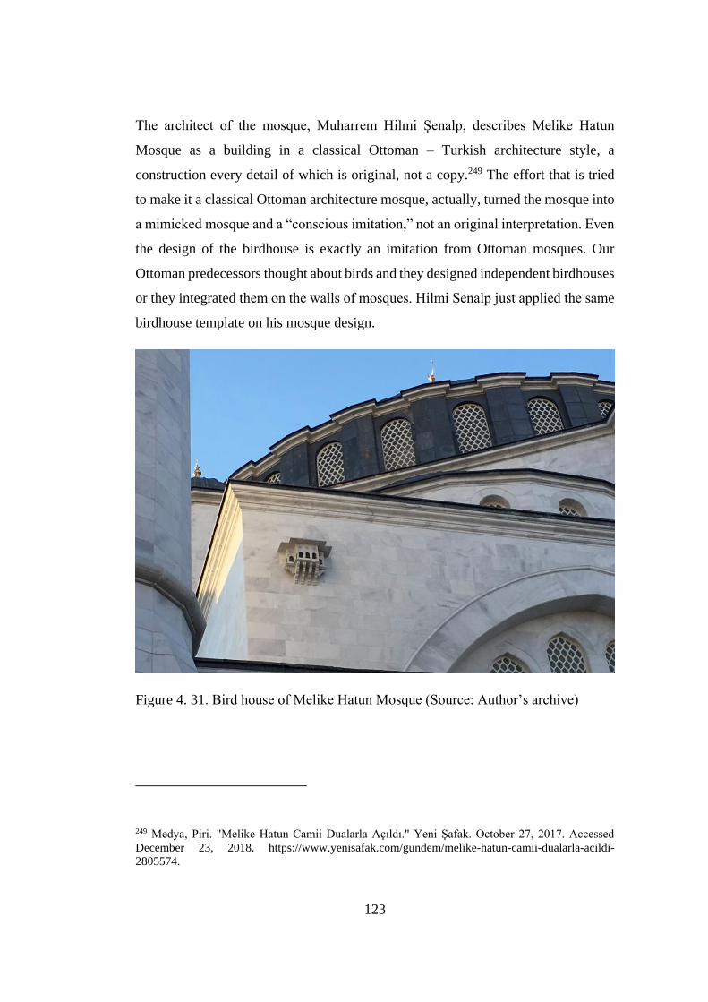
123
The architect of the mosque, Muharrem Hilmi Şenalp, describes Melike Hatun
Mosque as a building in a classical Ottoman – Turkish architecture style, a
construction every detail of which is original, not a copy.249 The effort that is tried
to make it a classical Ottoman architecture mosque, actually, turned the mosque into
a mimicked mosque and a “conscious imitation,” not an original interpretation. Even
the design of the birdhouse is exactly an imitation from Ottoman mosques. Our
Ottoman predecessors thought about birds and they designed independent birdhouses
or they integrated them on the walls of mosques. Hilmi Şenalp just applied the same
birdhouse template on his mosque design.
Figure 4. 31. Bird house of Melike Hatun Mosque (Source: Author’s archive)
249 Medya, Piri. "Melike Hatun Camii Dualarla Açıldı." Yeni Şafak. October 27, 2017. Accessed
December 23, 2018. https://www.yenisafak.com/gundem/melike-hatun-camii-dualarla-acildi-
2805574.
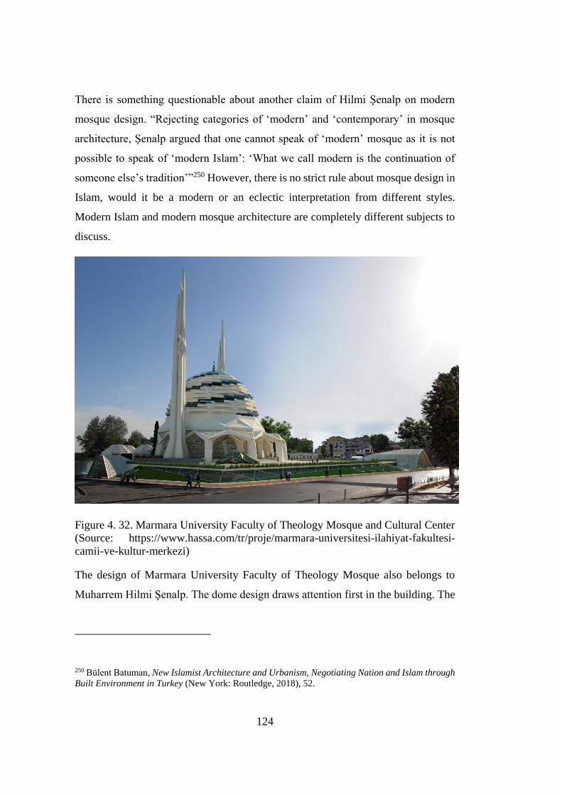
124
There is something questionable about another claim of Hilmi Şenalp on modern
mosque design. “Rejecting categories of ‘modern’ and ‘contemporary’ in mosque
architecture, Şenalp argued that one cannot speak of ‘modern’ mosque as it is not
possible to speak of ‘modern Islam’: ‘What we call modern is the continuation of
someone else’s tradition’”250 However, there is no strict rule about mosque design in
Islam, would it be a modern or an eclectic interpretation from different styles.
Modern Islam and modern mosque architecture are completely different subjects to
discuss.
Figure 4. 32. Marmara University Faculty of Theology Mosque and Cultural Center
(Source: https://www.hassa.com/tr/proje/marmara-universitesi-ilahiyat-fakultesi-
camii-ve-kultur-merkezi)
The design of Marmara University Faculty of Theology Mosque also belongs to
Muharrem Hilmi Şenalp. The dome design draws attention first in the building. The
250 Bülent Batuman, New Islamist Architecture and Urbanism, Negotiating Nation and Islam through
Built Environment in Turkey (New York: Routledge, 2018), 52.

125
architect designed the dome, using the traditional swallow (kırlangıc) dome
technique of 1000 years, inspired by the Turkish triangles, which are widely used in
Seljuk and Ottoman architecture. He created an original structure by interpreting the
minarets of the mosque with an original interpretation. Compared to Melike Hatun
Mosque, two entirely different design vocabulary are seen in this mosque. During
the interview with Hilmi Şenalp, it was asked the reason of the difference between
them. He replied as: “It is necessary to learn the classic correctly. For this, it must
either be demolished or rebuilt. We can build mosques such as Marmara Faculty of
Theology Mosque today, because we could rebuild classical mosques. Marmara
Theology Mosque is an interpretation of the classic.”251 In other words, he expressed
that there should be classical designs for original and modern interpretations.
“Imitating and building to seek and find what is lost are different.”252 He associated
finding and seeking the lost to an archaeological excavation. And he defines the
design of Melike Hatun Mosque as an archeological excavation, not an imitation.
Yeşilvadi Mosque can be another example for one of the modern mosques in Turkey.
It was designed by the architect Adnan Kazmaoğlu by Kiptaş Architecture Office. It
was commissioned by the Municipality of Istanbul in 2004. Kiptaş shares the same
ideology with the current political environment and Hilmi Şenalp but the style of
Yeşilvadi Mosque is quite modern. In addition:
“The traditional elements are used in a totally new and innovative way, both
in terms of their forms and the materials used... Yeşilvadi Mosque is an
interpretation of a domed mosque, which is made up of two different sized
domes brought together in order to increase the spatial quality.”253
251 Muharrem Hilmi Şenalp, Interview by author. Personal interview, İstanbul, June 10, 2021. 252 Muharrem Hilmi Şenalp, “Türk Ve İslam Dünyası’nın Kültür ve Medeniyet Vizyonu Ne
Olmalıdır?”. 253 Özgür Ürey, “Use of Traditional Elements in Contemporary Mosque Architecture in Turkey”
(M.Sc. diss., Middle East Technical University, 2010), 130.
126
One can actually speak of modern mosque like the case in Yeşilvadi Mosque. Instead
of interpretation as in the example, there is a case of imitation in Melike Hatun
Mosque. Being modern does not mean to ignore traditional elements. Interpretation
helps to use traditional elements in design. Just like in the design of Marmara
University Faculty of Theology Mosque.
Muharrem Hilmi Şenalp was also asked about the scale of the mosque during the
interview. He explained as: "We tried to find a scale that could describe its
surroundings. If I wanted to make it more visible, I could move it closer to Atatürk
Boulevard. But we didn't do it to create spaciousness in that area. I didn't want to
eliminate the concept of the square.” Finding a scale that could describe surrounding
is a critical point. The office deliberately selected a scale that dominates the
environment. However, the square was already described by the buildings around.
4.3.1 Evaluation of the Melike Hatun Mosque with respect to collective
memory and memory of place
Ankara, the new capital of the nation state, is being built by the architect planners of
that period in line with their own understanding. Planners were trying to create a
spatial setting suitable for the ideology of Early Republican period. What we call the
capital is not only a place with modern buildings and beautiful parks, but beyond
that, it is planned and built as a city with some places and monumental structures
that symbolize the nation state in the understanding of that period. Ankara was one
of the cities that needed that spatial framework compatible with the understanding
of the nation state. This spatial framework, which started with Lörcher, continued
with Jansen's developments, and the growing city became the scene of larger-scale
plans. This part of the chapter specifically examine Melike Hatun Mosque with
respect to the powerful urban axes of Lörcher and Jansen Plans under the notion of
collective memory and memory of place.

127
Lörcher held the axial organization in his urban design. These axes had very effective
role in cognitive maps of people. Because Lörcher designed monumental structures
at the ends of axes. For example, the Castle was the focal point of most axes. At one
side of Atatürk Boulevard, there was a parliament building designed as a
monumental structure. Along the axis, Lörcher defined a number of cultural
structures such as Ethnography Museum and Painting and Sculpture Museum which
are monumental structures at a high point, public buildings, and recreational areas
on the axis. Jansen Plan maintained many axes of Lörcher’s. The Early Republican
period, while establishing a nation-state, is building a city environment to support a
new collective identity, for the nation. While doing this, it uses cultural structures,
art and sculptures. Later, monumental structures continued to be built at the end of
the major axes of the early republican period. However, this time, the way the
dominant ideology expresses itself changed. The collective memory that the nation
state tried to establish in the early period of the Republic was to be altered. Kocatepe
Mosque is the example of such attempt in 1970s. It is today located at the end of
Mithat Paşa Boulevard which is one of the main axis of Ankara and like Ankara
Castle, the mosque is quite visible from many point of Ankara. As a monumental
structure, instead of cultural institutions, the dominant understanding of that period
wanted to define itself with a religious structure. The case of Melike Hatun Mosque
in Hergelen Square is the same issue of representing today’s dominant
understanding.
Hergelen Square is located at the intersection of Atatürk Boulevard, which is the
main axis, and the middle axis of the Youth Park. The location of the square is
actually an end point of the strong perspective axis through the Youth Park. It is at
the end of a perspective axis that can be seen when looking in the direction of Youth
Park from the train station. With its size, Melike Hatun Mosque can easily be
perceived as a monumental structure from inside of the Youth Park and from İstanbul
Street. As explored in the beginning of the chapter, the area is mainly characterized
by the Early Republican spaces, buildings and art works. Lörcher in his design
defined Hergelen Square as a theatre square which is a cultural institution. Jansen
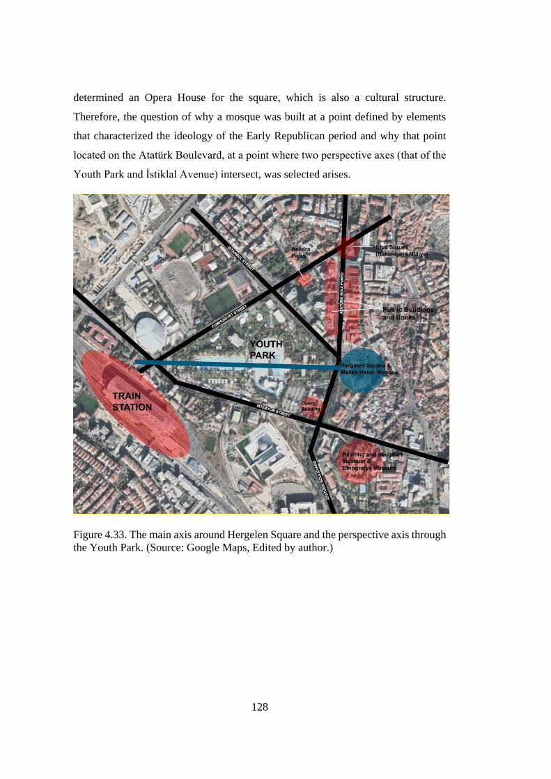
128
determined an Opera House for the square, which is also a cultural structure.
Therefore, the question of why a mosque was built at a point defined by elements
that characterized the ideology of the Early Republican period and why that point
located on the Atatürk Boulevard, at a point where two perspective axes (that of the
Youth Park and İstiklal Avenue) intersect, was selected arises.
Figure 4.33. The main axis around Hergelen Square and the perspective axis through
the Youth Park. (Source: Google Maps, Edited by author.)
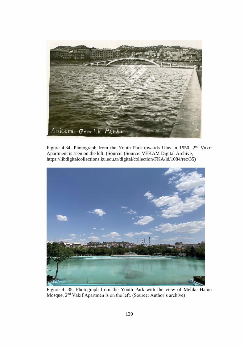
129
Figure 4.34. Photograph from the Youth Park towards Ulus in 1950. 2nd Vakıf
Apartment is seen on the left. (Source: (Source: VEKAM Digital Archive,
https://libdigitalcollections.ku.edu.tr/digital/collection/FKA/id/1084/rec/35)
Figure 4. 35. Photograph from the Youth Park with the view of Melike Hatun
Mosque. 2nd Vakıf Apartmen is on the left. (Source: Author’s archive)
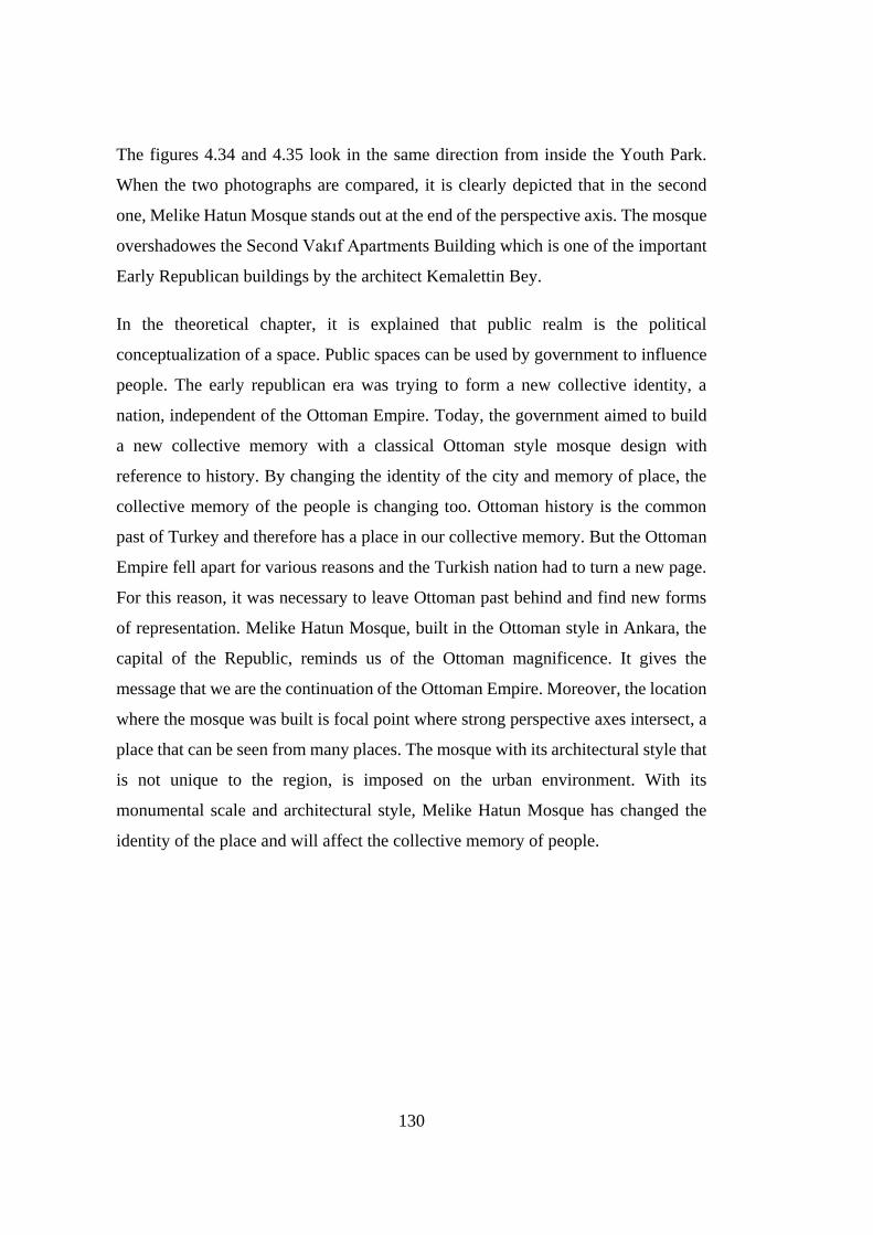
130
The figures 4.34 and 4.35 look in the same direction from inside the Youth Park.
When the two photographs are compared, it is clearly depicted that in the second
one, Melike Hatun Mosque stands out at the end of the perspective axis. The mosque
overshadowes the Second Vakıf Apartments Building which is one of the important
Early Republican buildings by the architect Kemalettin Bey.
In the theoretical chapter, it is explained that public realm is the political
conceptualization of a space. Public spaces can be used by government to influence
people. The early republican era was trying to form a new collective identity, a
nation, independent of the Ottoman Empire. Today, the government aimed to build
a new collective memory with a classical Ottoman style mosque design with
reference to history. By changing the identity of the city and memory of place, the
collective memory of the people is changing too. Ottoman history is the common
past of Turkey and therefore has a place in our collective memory. But the Ottoman
Empire fell apart for various reasons and the Turkish nation had to turn a new page.
For this reason, it was necessary to leave Ottoman past behind and find new forms
of representation. Melike Hatun Mosque, built in the Ottoman style in Ankara, the
capital of the Republic, reminds us of the Ottoman magnificence. It gives the
message that we are the continuation of the Ottoman Empire. Moreover, the location
where the mosque was built is focal point where strong perspective axes intersect, a
place that can be seen from many places. The mosque with its architectural style that
is not unique to the region, is imposed on the urban environment. With its
monumental scale and architectural style, Melike Hatun Mosque has changed the
identity of the place and will affect the collective memory of people.
131
CHAPTER 5
CONCLUSION
As explained in the theoretical chapter of thesis, collective memory is socially
constructed notion. Maurice Halbwachs states that collective memory needs a group
and a space that the group engaged in. Here space indicates physical environment of
people. In order to remember a memory, it is needed an impulse. Physical
environment supplies that impulse for memories to come out. Architecture is an
integral part of this physical environment.
Memory establishes a relationship with the place in which it is located. Thanks to
this relationship, we redefine space as a concept that encodes our past experience.
Space becomes a tool for the recuperation of our past experience in memory. In this
respect, cities where human action occurs also have a spatial content. Cities exist as
memory models, combining the past, present and future with both its physical and
social environment. Therefore, the city undertakes the functions of recalling and
keeping the memory alive. As Halbwachs posited, collective memory needs a
physical environment. Each community leaves certain traces in the space in order to
keep their memories active and revives their memories through these traces. From
this point of view, the city squares are the places where the city's self-memory is
formed and where it becomes clearly visible. They play a vital role in the acquisition
and preservation of memory.
Along their various functions throughout history, squares appear as open spaces that
societies assume very remarkable. They are the reference and attraction point of the
city and the places where the people gather. Squares are public places shared by the
citizens in common. “They create a gathering place for the people, humanizing them
by mutual contact, providing them with a shelter against the haphazard traffic, and
132
freeing them from the tension of rushing through the web of streets.”254 The
characteristics of the squares are a reflection of the development and social
organization of the city. Habermas describes public places as realms of social life
and in consequence of this social life, a public opinion formed. And squares as public
areas also carry traces of memories of public. They have historical and social
indications with specific elements that define their environment. With its history,
important elements and location, public places can also be a political tool. For
governments, open areas are essential in terms of public attractions. As illustrated in
the theoretical part of thesis, there can be various organizations held in open public
areas such as opposing or supporting demonstrations against the government or
cultural activities etc. “Public spaces of a city have always had political significance,
symbolizing the power of the state.”255 With this power, the memory of place can be
altered. Collective memory of people too. In that sense, the context of an area in a
city is crucial for the minds of public.
Sustaining the city and urbanism as a public space is directly related to the multi-
layered historical texture and the existence of public spaces of the city center. Urban
centers with their historical places bear a highly significant place for collective
memory, which is an important component of the public sphere.256 Public remembers
through urban spaces, so remembering is an integral element of urban culture. Spatial
practice is the practice of simultaneously memorizing and preserving in memory.
Hergelen Square is one of the public places of Ankara that enable community to
practice the space. With its multi-layered historical context, it has an extensive place
in urban memory. “Spatial elements play an essential role in the formation of the
254 Paul Zucker, Town and Square: from the Agora to the Village Green. (New York: Columbia
University Press, 1959), 1. 255 Madanipour. “Why Are the Design and Development of Public Spaces Significant for Cities?”
Environment and Planning B: Planning and Design 26, no.6 (December 1999): 880. 256 Cânâ Bilsel, “Kentsel Dönüşüm, Çözülen Kentler ve Parçalanan Kamusal Alan”
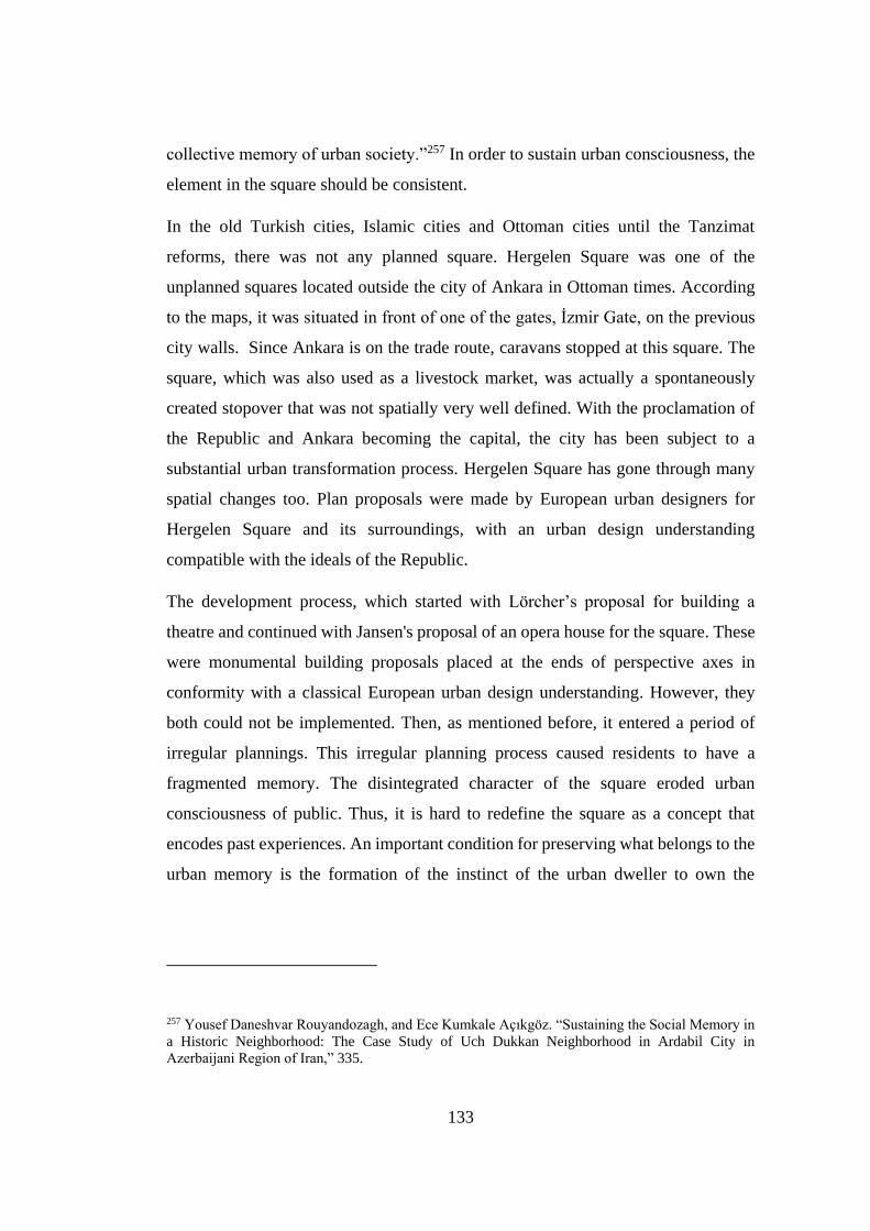
133
collective memory of urban society.”257 In order to sustain urban consciousness, the
element in the square should be consistent.
In the old Turkish cities, Islamic cities and Ottoman cities until the Tanzimat
reforms, there was not any planned square. Hergelen Square was one of the
unplanned squares located outside the city of Ankara in Ottoman times. According
to the maps, it was situated in front of one of the gates, İzmir Gate, on the previous
city walls. Since Ankara is on the trade route, caravans stopped at this square. The
square, which was also used as a livestock market, was actually a spontaneously
created stopover that was not spatially very well defined. With the proclamation of
the Republic and Ankara becoming the capital, the city has been subject to a
substantial urban transformation process. Hergelen Square has gone through many
spatial changes too. Plan proposals were made by European urban designers for
Hergelen Square and its surroundings, with an urban design understanding
compatible with the ideals of the Republic.
The development process, which started with Lörcher’s proposal for building a
theatre and continued with Jansen's proposal of an opera house for the square. These
were monumental building proposals placed at the ends of perspective axes in
conformity with a classical European urban design understanding. However, they
both could not be implemented. Then, as mentioned before, it entered a period of
irregular plannings. This irregular planning process caused residents to have a
fragmented memory. The disintegrated character of the square eroded urban
consciousness of public. Thus, it is hard to redefine the square as a concept that
encodes past experiences. An important condition for preserving what belongs to the
urban memory is the formation of the instinct of the urban dweller to own the
257 Yousef Daneshvar Rouyandozagh, and Ece Kumkale Açıkgöz. “Sustaining the Social Memory in
a Historic Neighborhood: The Case Study of Uch Dukkan Neighborhood in Ardabil City in
Azerbaijani Region of Iran,” 335.
134
urban.258 The disintegrated feature of the area damaged the urge of preserving urban
memory.
Irregular and incomplete planning of the square restrained the creation of social bond
with the square. With Otto Hajek’s sculpture, there was a try to establish a bond.
However, it could not be a part of an urban integrity. “It all comes back to community
process. No public art can succeed in enhancing the social meaning of place without
solid base of community support.”259 Large area of parking lot and the flea market
did not let people to internalize the art piece of Hajek. Spaces that can establish social
bonds can create resistance points in front of transformations that absorb urban
continuity and nuances.260
Figure 5. 1. View from İstanbul Street also called as protocol road. The Vakıf
Apartment and the Ottoman Bank are on the left. The scale of the Mosque is apparent
in terms of its surrounding. (Source: Author’s archive)
The latest arrangement of the square consists of a large mosque called Melike Hatun
Mosque. After all the irregular planning attempts, actually the latest plan made the
square gain the characteristic features of the square. “Squares are empty spaces
defined by the designed environment. In addition, in order for a place to be defined
258 İnci Basa, “Kentsel Hafızanın Sürdürülebilirliği: Bir Mimarlık Stüdyosu Deneyimi.” Sanat ve
Tasarım Dergisi, 32. 259 Dolores Hayden, The Power of Place: Urban Landscape as Public History (Cambridge, MA: The
MIT Press, 1995), 75. 260 İnci Basa, 33.
135
as a square, it must be pedestrianized as a priority.”261 Today, the area is
pedestrianized and has become a gathering point and an atmosphere that people can
share their ideas. There is a place of assembly and association for people and an
opportunity to encounter to one another. However, a large part of the area allocated
for the mosque and as scrutinized previously, the design and the style of the mosque
does not fit the urban and historical context of Ankara. The style of the mosque is
defined as an interpretation of the classic by the architect Muharrem Hilmi Şenalp.
Although he does not express himself as modern, when examining other designs of
the architect, they can be seen as original and modern in their architectural language.
However, in Melike Hatun's design, it can be posited that there were ideological
reasons that shaped the architectural design. In addition, the architect defended the
choice of such a scale in the mosque. The scale was consciously picked for
dominating the environment. Again, defining the square in a different scale and style,
unlike the elements that define the area, may result from political decisions.
It was posited that there was no planned square in Ottoman cities before the
Tanzimat. Most of the existing squares were spontaneously shaped open spaces.
Hergelen Square was actually a square that was also formed spontaneously, used as
a livestock market place and frequented by caravans. During the planning period of
Ankara, the square was attempted to be re-defined by European urban planners.
However, this square could not be re-identified, either as a theatre square as proposed
by Lörcher, or a square in front of a monumental opera house as proposed by Jansen.
Considering that the plans that were prepared for this area later could not be
implemented, the following argument could be maintained: Hergelen Square might
be a public open space that should have remained empty. The location of the square
is not suitable for any architectural and monumental structure that would dominate
its surroundings. Because there are already several buildings from different periods,
261 Çiğdem Varol et. al., Başkent'in Meydanı Kızılay'ın Dönüşüm Öyküsü. Edited by Alev Ayaokur
(Ankara: Koç Üniversitesi VEKAM, 2019), 15.
136
including the Early Republican period that define the perimeters of the square. Any
monumental structure designed for the square is capable of disrupting the character
of the place.
The decision of designing Melike Hatun Mosque as part of an urban design project
and with a historicist, monumental architectural style was a conscious political urban
decision. This is also understood from the statement of Hilmi Şenalp as he stressed:
“we tried to find a scale that could describe its surroundings.” They consciously
wanted to reshape the area with reference the mosque. This intervention has created
a discontinuity in the public sphere of Hergelen Square in terms of collective
memory. As Christine Boyer expresses for postmodern historicism: “The
discontinuities and ruptures, difference and otherness they uncritically celebrate
impose severe consequences on the public realm of the city. They have caused any
sense of collectivity to disappear and undermined any attempt to take critical
stance.”262 Today, there is an otherness in Hergelen Square, located at the gate of the
old town. By manipulating historical references in the design of the mosque, the
identity and memory of the place has been drastically changed. The atmosphere of
the place, that was once characterized both by historic structures, and the public open
spaces and buildings from the Early Republican period, has been radically altered
under a certain political approach which was concretized in the architecture of
Melike Hatun Mosque.
The continuation of any political structure depends on the power of the memory and
identity of urban and spatial practices. Urban and spatial practices and accordingly
architecture have an immense role in the perpetuation of memory and identity of a
city. Melike Hatun Mosque imposes itself in an urban context, which was
characterized by spaces and works of the Early Republican period in particular. Yet,
at the same time, it has displaced the preexisting spatial relations with its scale and
262 M. Christine Boyer, “The City of Collective Memory, Its Historical Imagery and Architectural
Entertainments (Massachusetts: The MIT Press, 1994), 480.
137
the way it merged the religious space of the mosque with the public space of the
square. It has changed the character of the place both with the scale and architectural
style, and also by changing the social practices that take place there. As Meltem
Gürel and Serpil Özaloğlu pointed out, “the mosque has been not only a place for
religious practices but also a social space, allowing the formation of individual,
social, and collective memories.”263 Melike Hatun Mosque dominates its urban
context and the surrounding. It is an attempt to change the memory of place with the
aim of altering the collective memory of the citizens by spatializing a political
discourse. Until the last arrangement for the square, it was not possible to mention
about a steady urban memory for Hergelen Square. With the complete rearrangement
of the public open space and the construction of a monumental mosque in the middle
of it, the character of the locus has been drastically changed.
263 Meltem Gürel, Serpil Özaloğlu, “Designing Mosques for secular congregations: Transformations
Of The Mosque As A Social Space In Turkey,” Journal of Architectural and Planning Research 28,
no.4 (Winter 2011): 336.

138
139
REFERENCES
Alanyalı Aral, Ela. “Ankara Kentinde Frig Dönemi İzleri –Frig Tümülüsleri
Üzerine Bir Araştırma.” Türkiye Bilimler Akademisi Kültür Envanteri
Dergisi, no. 15 (2017): 167–89.
https://doi.org/10.22520/tubaked.2017.15.002.
Aliağaoğlu, Alpaslan, and Abdullah Uğur. “Osmanlı Şehri.” SDÜ Fen Edebiyat
Fakültesi Sosyal Bilimler Dergisi, no. 38 (August 2016): 203–26.
Aliağaoğlu, Alpaslan, and Alper Uzun. “Şehirsel Toponimi (Hodonimi): Türkiye
İçin Bir Tipoloji Denemesi.” Coğrafi Bilimler Dergisi, 2, 9 (2011): 123–33.
https://doi.org/10.1501/cogbil_0000000121.
Allan, Kenneth. Explorations in Classical Sociological Theory: Seeing the Social
World. USA: Pine Forge Press, 2005.
Altan Ergut, Elvan. “BİNA KİMLİKLERİ SÖYLEŞİSİ 5 ‘SERGİ EVİ VE OPERA
BİNASI.’” mimarlarodasiankara, December 24, 2009.
http://www.mimarlarodasiankara.org/_media/6/5533.pdf.
Altan, T. Elvan. “The Forming of the National in Architecture.” METU Journal of
the Faculty of Architecture, 1-2, 19 (1999): 31–43.
https://www.academia.edu/38158547/The_Forming_of_the_National_in_Ar
chitecture.
Apfelbaum, Erika. "Halbwachs and the Social Properties of Memory." In Memory:
Histories, Theories, Debates, edited by RADSTONE SUSANNAH and
SCHWARZ BILL, 77-92. NEW YORK: Fordham University Press, 2010.
Accessed November 11, 2020. doi:10.2307/j.ctt1c999bq.9.
140
“Atatürk Hakkında Bilmek İstediğiniz Herşey.” İşte Atatürk. Accessed July 1,
2021. https://isteataturk.com/g/icerik/Ulus-Ataturk-Aniti-Ankara/1470.
Aydın, Suavi, Kudret Emiroğlu, Ömer Türkoğlu, and Ergi D. Özsoy. Kücük Asya'nın
Bin Yüzü: Ankara. Ankara: Dost Kitabevi, 2005.
Aygün, Sevna. “Otto Herbert Hajek Hergelen Meydanı Çevre Düzenlemesi Ulus.”
Edited by Ali Artun. ANKARA BÜYÜKŞEHIR BELEDIYESI ÇEVRE SANAT
ETKINLIKLERI MART 1989 MART 1994, 1994.
Bademli, R. Raci. “Hergelen Meydanı.” Essay. In Ankara söyleşileri: Kasım-Aralık
1993, edited by Çimen Bayar, 7–11. Ankara: TMMOB Mimarlar Odası
Ankara Şubesi, 1993.
Basa, İnci. “Kentsel Hafızanın Sürdürülebilirliği: Bir Mimarlık Stüdyosu
Deneyimi.” Sanat ve Tasarım Dergisi, no. 15 (June 2015): 27–42.
Basa, İnci. “Producing Representational Spaces for the Republican Memory in
Samsun, Turkey,” Turkish Historical Review 7, (2016).
Batuman, Bülent. “Identity, Monumentality, Security.” Journal of Architectural
Education 59, no. 1 (August 4, 2005): 34–45. https://doi.org/10.1111/j.1531-
314x.2005.00004.x.
Batuman, Bülent. New Islamist Architecture and Urbanism, Negotiating Nation and
Islam through Built Environment in Turkey. New York: Routledge, 2018.
141
Batur, Enis, ed. Ankara Ankara. İstanbul: Yapı Kredi Yayınları, 1994.
Bayramoğlu Alada, Adalet. Osmanlı Şehrinde Mahalle. İstanbul: Sümer Kitabevi,
2008.
Bilsel, Can. “Architecture and the Social Frameworks of Memory: A Postscript to
Maurice HALBWACHS' ‘Collective Memory.’” Iconarp International J. of
Architecture and Planning 5, no. 1 (June 30, 2017): 01–09.
https://doi.org/10.15320/iconarp.2017.14.
Bilsel, Fatma Cânâ. “Ankara'da Kentsel Başkalaşım Karşısında Kentsel Kimlik Sorunu:
Kent Merkezleri ve Kamusal Mekanlar.” Dosya 10, 2 (2009): 33-46.
Bilsel, Cânâ. “Kentsel Dönüşüm, Çözülen Kentler ve Parçalanan Kamusal Alan”
Mimarlıkdergisi.com. Accessed December 19, 2018.
http://www.mimarlikdergisi.com/index.cfm?sayfa=mimarlik&DergiSayi=41
&RecID=
Bilsel, S. Güven “Kent ve Kentli Kültürü, Kimlik Sorunsalı, Yaşanılası Kentsel
Mekan ve Ankara.” Dosya, February 2009, 51.
http://www.mimarlarodasiankara.org/dosya/dosya10-1.pdf.
Boyer, M. Christine. The City of Collective Memory Its Historical Imagery and
Architectural Entertainments. Massachusetts: MIT Press, 1994.
Busquet, Grégory. “Political Space in the Work of Henri Lefebvre: Ideology and
Utopia.” jssj, December 2012. https://www.jssj.org/wp-
content/uploads/2013/09/JSSJ5-3.en_1.pdf.
142
Casey, Edward S. Remembering, Second Edition : A Phenomenological Study. Vol.
Second edition. Studies in Continental Thought. Bloomington: Indiana
University Press,
2000.http://search.ebscohost.com/login.aspx?direct=true&AuthType=ip&db=
nlebk&AN=653044&site=eds-live.
Carmona, Matthew, Tim Heath, Taner Oc, and Steve Tiesdell. Public Places - Urban
Spaces: The Dimensions of Urban Design. Burlington, MA: Architectural
Press, 2003.
Cengizkan, Ali. Ankara’nın Ilk Planı 1924-25 Lörcher Planı. Ankara: Arkadaş
Yayıncılık, 2004.
Cengizkan, Ali, A. Derin. İnan, and N. Müge. Cengizkan. Modernist Acılımda Bir
Öncü: Seyfi Arkan. Ankara: Mimarlar Odası Yayınları, 2012.
Cengizkan, Ali. “Türkiye Için Modern Ve Planlı Bir Başkent Kurmak: Ankara 1920-
1950.” goethe.de. Accessed March 13, 2021.
https://www.goethe.de/ins/tr/ank/prj/urs/geb/sta/trindex.htm.
Cengizkan, N. Müge. “Moderne Yönelik Yeni Bir Yıkım Tehdidi Daha: Seyfi
Arkan’In İller Bankası Binası.” mimarlikdergisi, 2015.
http://www.mimarlikdergisi.com/index.cfm?sayfa=mimarlik&DergiSayi=395
&RecID=3565.
Cinar Ozdil, Nevruz, Henrik Vejre, and Fatma Cana Bilsel. “Emergence and
Evolution of the Urban Public Open Spaces of Ankara within the Urban
Development History: 1923 to Present.” Journal of Planning History 19, no. 1
(February 2020): 26–51. https://doi.org/10.1177/1538513219848434.
143
“City.” etymonline, n.d. https://www.etymonline.com/word/city.
Coser, Lewis A., ed. Maurice Halbwachs on Collective Memory. Chicago: The
University of Chicago Press, 1992.
Crinson, Mark. Urban Memory History and Amnesia in the Modern City. London:
Routledge, 2005.
Cross, Toni Marie, and Gary Leiser. A Brief History of Ankara. Vacaville, Calif:
Indian Ford Press, 2000.
Çimen, Bayar. “Hajek Meydanı.” Essay. In Ankara söyleşileri: Kasım-Aralık 1993,
edited by Çimen Bayar, 12. Ankara: TMMOB Mimarlar Odası Ankara Şubesi,
1993.
Çimen, Bayar. “Ankara'nın Yeni Meydanları.” Mimarlık no. 250, 1992.
Çimen, Bayar. “Kentsel ve Mimari Mekanda Sanat Hergelen Meydanı Otto Herbert
Hajek.” Mimarlık no. 256, 1994.
Çinici, Damla. “Başkent Ankara’Nın İnşasında Etkin Bir Mimar: Giulio Mongeri Ve
Yaşam Öyküsü.” Ankara Araştırmaları Dergisi 3, no. 1 (June 14, 2015): 13–
41.
Demirel, Emre. “The Haptic and Visual Considerations of Public Spaces: Otto
Herbert Hajek’s Proposal for Hergelen Square in Ankara .” Online Journal of
Art and Design 7, no. 1 (January 2019): 202–19.
144
Dinçer, Özgür. “Axiality In The Process Of Space Organization In Architecture,”
M. Sc. Diss., İzmir Institute of Technology, 1999.
Dumont, Paul, and Georgeon François. Modernleşme Sürecinde Osmanlı Kentleri.
Translated by Ali Berktay. Beşiktaş, İstanbul: Tarih Vakfı Yurt Yayınları,
1996.
Erdoğdu, Şeref. Ankara'nın tarihi Semt Isimleri Ve öyküleri. Ankara: T.C. Kültür
Bakanlığı, 2002.
Erzen, Afif. Ilkcagda Ankara. Ankara: Türk Tarih Kurumu Basımevi, 2010.
Evin, Ahmet, and Renata Holod, eds. Modern Turkish Architecture. Ankara:
Chamber of Architects of Turkey, 2005.
Eyice, Semavi. Ankara'nın Eski Bir Resmi tarihi Vesika Olarak Resimler -
Ankara'dan Bahseden Seyyahlar - Eski Bir Ankara Resmi. Ankara: Türk Tarih
Kurumu Basımevi, 1972.
Eyice, Semavi. “Bizans Döneminde Ankara.” Anadolu Araştırmaları, no. 14 (1996):
243–64. https://dergipark.org.tr/tr/pub/iuanadolu/issue/1160/13590.
Gedi, Noa, and Yigal Elam. "Collective Memory — What Is It?" History and
Memory 8, no. 1 (1996): 30-50. Accessed October 6, 2020.
http://www.jstor.org/stable/25618696
Gözaydın, Nevzat. “Başkent’Te Yer Adları Üzerine.” Türk Dili 68, no. 794
(February 2018): 21–25. https://tdk.gov.tr/wp-
content/uploads/2018/02/5_Nevzat-G%c3%96ZAYDIN .pdf.
145
Günduz, Ali Yılmaz, Mehmet Kaya, and Cahit Aydemir. “AHİLİK
TEŞKİLATINDA VE GÜNÜMÜZDE TÜKETİCİLERİN KORUNMASINA
YÖNELİK ÇALIŞMALAR ÜZERİNE BİR DEĞERLENDİRME.” Afyon
Kocatepe Üniversitesi, IIBF Dergisi 14, no. 2 (2012): 37–54.
https://dergipark.org.tr/tr/download/article-file/18878.
Gürel, Meltem, and Serpil Özaloğlu. “Designing Mosques for secular congregations:
Transformations Of The Mosque As A Social Space In Turkey.” Journal of
Architectural and Planning Research 28, no.4 (Winter 2011).
Habermas, Jürgen, Sara Lennox, and Frank Lennox. "The Public Sphere: An
Encyclopedia Article (1964)." New German Critique, no. 3 (1974): 49-55.
doi:10.2307/487737.
Harvey, David. Justice, Nature and the Geography of Difference. Oxford: Blackwell,
1996.
Hayden, Dolores. The Power of Place: Urban Landscape as Public History.
Cambridge, MA: The MIT Press, 1995.
Hobsbawm, E. J., and T. O. Ranger. The Invention of tradition. Cambridge
[Cambridgeshire]: Cambridge University Press. 1983.
Kadıoğlu Musa, Görkay Kutalmış, and Stephen Mitchell. Roma Döneminde
Ankyra. İstanbul: Yapı Kredi Yayınları, 2018.
Karaelmas, Elif. “Mosques Of Ankara: Objects Of Ideological Representation Since
The1950s” M.Sc. diss., Middle East Technical University, 2014.
146
Karaman, Ramazan. “TÜRK AHİ TEŞKİLATININ İŞLEYİŞİ VE ÇORUM
TARİHİNDE AHİLİK.” Hitit Üniversitesi Sosyal Bilimler Enstitüsü Dergisi
7, no. 1 (June 2014): 93–109. https://dergipark.org.tr/tr/download/article-
file/86073.
Kezer, Zeynep. Building Modern Turkey : State, Space, and Ideology in the Early
Republic. Culture Politics & the Built Environment. Pittsburgh, Pa:
University of Pittsburgh Press, 2015.
http://search.ebscohost.com/login.aspx?direct=true&db=nlebk&AN=11717
78&site=ehost-live.
Kılıç, Abdurrahman. “Bir İtfaiye Duayeni Baki Akansel.” yangin.org. Accessed
April 3, 2021.
http://www.yangin.org/dosyalar/bir_itfaiye_duayeni_baki_akansel.pdf.
Kip Akyol, Ayça Nur. “Karyağdı Hatun Türbesinden Operaya Bir Opera
Etnografisi,” Phd diss., Ankara Üniversitesi, 2016.
Koç, Bekir, and Mehmet Murat Baskıcı. Bozkırdan Sanayinin başkentine: Ankara
Sanayi Tarihi. Ankara: Ankara Sanayi Odası, 2013.
Köroğlu, N. Tunga, and Ebru Ölmez. “Cumhuriyetin 75. Yılında Planlama Sergisi.”
Planlama 4 (2002): 7–21.
https://www.spo.org.tr/resimler/ekler/6edc1cd1f36e45d_ek.pdf.
Kumkale Açıkgöz, Ece. “Keeping the Pulse of Heritage Awareness in Ankara: Two
Historic Sites, Two Interventions.” Journal of Contemporary Urban Affairs 3,
no. 2 (2019): 63–72. https://doi.org/10.25034/ijcua.2018.4702.
147
Kuran, Aptullah. Selcuklular'dan Cumhuriyet'e Türkiye'de Mimarlık. Edited by
Kafescioğlu Çiğdem, Thys-Şenocak Lucienne, and Timur Kuran. İstanbul:
Türkiye İş Bankası, 2012.
Larice, Michael, and Elizabeth Macdonald, eds. The Urban Design Reader. New
York: Routledge, 2013.
Lefebvre, Henri, and Donald Nicholson-Smith. The Production of Space. Malden,
MA: Blackwell, 2011.
Mantovani, Lorenzo. “Philology and Toponymy. Commons, Place Names and
Collective Memories in the Rural Landscape of Emilia.” Philology 2 (2016):
237–54.
Madanipour, A. “Why Are the Design and Development of Public Spaces Significant
for Cities?” Environment and Planning B: Planning and Design 26, no. 6
(December 1999): 879–91
Medya, Piri. "Melike Hatun Camii Dualarla Açıldı." Yeni Şafak. October 27, 2017.
Accessed December 23, 2018.
https://www.yenisafak.com/gundem/melike-hatun-camii-dualarla-acildi-
2805574.
“Mekan: Ulus Ankara'da Yitmekte Olan Kültür Ve Tabiat Varlıkları: Mekan, İnsan
Ve Kentin Tarihi.” Şehir Plancıları Odası Ankara Şubesi, 2019.
Mıhçıoğlu, Elif. “The Physical Evolution of the Historic City of Ankara Between
1839 and 1944: A Morphological Analysis” PhD diss., Middle East Technical
University, 2010.

148
Norberg-Schulz, Christian. Genius Loci: towards a Phenomenology of Architecture.
New York: Rizzoli, 1996.
Olick, Jeffrey K., Vered Vinitzky-Seroussi, and Daniel Levy. The Collective
Memory Reader. New York: Oxford University Press, 2011.
Ozdil, Nevruz, Henrik Vejre, And FATMA CÂNÂ BİLSEL. "Emergence and
Evolution of the Urban Public Open Spaces of Ankara within the Urban
Development History: 1923 to Present," JOURNAL OF PLANNING
HISTORY , vol.19, 26-51, 2020.
“Otto Herbert Hajek.” Santa & Cole, November 30, 2020.
https://www.santacole.com/en/biographies/?otto-herbert-hajek.
Özaloğlu, Serpil. "İller Bankası'nın Yıktırılmasının Düşündürdükleri."
Arkitera.com. Accessed December 10, 2018.
http://www.arkitera.com/gorus/1054/iller-bankasinin-yiktirilmasinin-
dusundurdukleri.
Özaloğlu, Serpil. “The Lived Spatiality of Ankara (1935-1950) through the
Memories of Its Citizens.” Essay. In Power and Culture: New Perspectives
on Spatiality in European History, 19–43. Edizioni Plus-Pisa University
Press, 2008. http://repository.bilkent.edu.tr/handle/11693/51928.
Peker, Ali Uzay. “Masterworks of Medieval Architecture in East and West,” Lecture
Notes, Middle East Technical University, Feb 15, 2018.

149
Parsaee, Mojtaba, Mohammad Parva, and Bagher Karimi. “Space and Place
Concepts Analysis Based on Semiology Approach in Residential Architecture
The Case Study of Traditional City of Bushehr, Iran.” HBRC Journal 11, no.
3 (May 17, 2019): 368–83.
Rapoport, Amos. Human Aspects of Urban Form towards a Man-Environment
Approach to Urban Form and Design. Oxford, NY, Toronto, Sydney, Paris,
Frankfurt Main: Pergamon Press, 1977.
Rossi, Aldo. The Architecture of the City. New York: MIT Press, 1982
Rouyandozagh, Yousef Daneshvar, and Ece Kumkale Açıkgöz. “Sustaining the
Social Memory in a Historic Neighborhood: The Case Study of Uch Dukkan
Neighborhood in Ardabil City in Azerbaijani Region of Iran.” International
Journal of Architectural and Environmental Engineering 11, no. 3 (2017):
334–39.
Sargın, Güven Arif, ed. Başkent Üzerine Mekan-Politik Tezler, Ankara’nın Kamusal
Yüzler. İstanbul: İletişim Yayıncılık, 2002.
Sargin, Güven Arif. “Displaced Memories, or the Architecture of Forgetting and
Remembrance.” Environment and Planning D: Society and Space 22, no. 5
(October 2004): 659–80. https://doi.org/10.1068/d311t.
Sargın, Güven Arif. “Kentin Kamusal Kimliğinin Çatkılanmasında İdeoloji Ve
İdeolojik Çatışma .” Dosya, February 2009.
http://www.mimarlarodasiankara.org/dosya/dosya10-1.pdf.
Sevinç, Mustafa. “Bir Hafıza Mekanı Olarak Kent Meydanı Ve Dönüşümü: Otto
Herbert Hajek’in Ankara Hergelen Meydan Projesi Örneği.” Akdeniz Sanat
Dergisi 13, no. 24 (July 19, 2019): 47–62.
150
Sitte, Camillo. “The Art of Building Cities.” Google Kitaplar. Google. Accessed
February 11, 2021. https://books.google.com.tr/books?id=WVS-
DwAAQBAJ&pg=PT21&hl=tr&source=gbs_toc_r&cad=3#v=onepage&q&f
=false.
Suskind, Dana. Otuz Milyon Kelime. Ankara: Buzdağı Yayınevi, 2020.
Şenalp, Muharrem Hilmi. Interview by author. Personal interview. İstanbul, June 10,
2021.
Şenalp, Muharrem Hilmi. “Türk Ve İslam Dünyası’nın Kültür ve Medeniyet
Vizyonu Ne Olmalıdır?” hassa. Accessed June 7, 2021.
https://www.hassa.com/tr/kirkambar/yazi/turk-ve-islam-dunyasinin-kultur-
ve-medeniyet-vizyonu-ne-olmalidir.
Tamur, Erman. Suda Suretimiz cıkıyor: Ankara Dereleri üzerine Tarihi Ve güncel
Bilgiler. Ankara: Kebikeç, 2012.
Tankut Gönül. Bir Başkentin Imarı: Ankara: 1929-1939. Cağaloğlu, İstanbul:
Anahtar Kitablar, 1993.
Tipi, Çiğdem Belgin. “Hergelen Meydanı Çevre Düzenleme ve Korumasına İişkin
Öneriler” M.Sc. diss., Gazi University, 1996.
151
TMMOB Mimarlar Odası Ankara Şubesi, “Tescilli Kültür Varlığı Olarak İller
Bankası Durum Raporu” Mimarlarodasiankara.org. Accessed December 10,
2018.
http://www.mimarlarodasiankara.org/download/IllerBankasiDurumRaporu.p
df.
Tuncer, Mehmet. Ankara (Angora) Sehri Merkez Gelisimi (14.-20. Yy). Ankara:
Kultur Bakanligi, 2001.
Tunçer, Mehmet. “Ankara Tarihi Kent Merkezi Yenileme Alanı Koruma Planı,
Niteliği Ve İptaline İlişkin Gerekçeler.” Ankara Araştırmaları Dergisi 1, no. 2
(December 2013): 10–34.
Türkoğlu, Kamutay, and Ahmet Uzel, Ulus Tarihi Kent Merkezi Koruma/Islah Imar
Planı Kapsamında: Koruma/Sağlıklaştırma Vaziyet Planı Önerisi Acıklama
Raporu, Ankara Metropolitan Municipality Zoning Archive, March 1990.
Uludağ, Zeynep, and Hilal Aycı. “Modernin Güçlü Sahnesi Erken Cumhuriyet
Dönemi Ankara’Sında Kolektif Belleğin İnşası Ve Toplumsal Unutma
Süreci.” Kent Araştırmaları Dergisi 7, no. 20 (December 2016): 746–73.
https://dergipark.org.tr/tr/download/article-file/466205.
Ürey, Özgür. “Use of Traditional Elements in Contemporary Mosque Architecture
in Turkey” M.Sc. diss., Middle East Technical University, 2010.
Varol Çiğdem, N. Aydan Sat, S. Bahar Yenigül, and Z. Aslı Gürel Üçer. Başkent'in
Meydanı Kızılay'ın Dönüşüm Öyküsü. Edited by Alev Ayaokur. Ankara: Koç
Üniversitesi VEKAM, 2019.
Yavuz, Ayşıl Tükel. Tarih icinde Ankara: Eylül 1981 Seminer Bildirileri . Ankara:
Orta Doğu Teknik Üniversitesi Ankaralılar Vakfı, 2000.
152
Yavuz, Yıldırım. Tarih icinde Ankara: Aralık 1998 Seminer Bildirileri. Ankara:
ODTÜ, 2001.
Zucker, Paul. Town and Square: from the Agora to the Village Green. New York:
Columbia University Press, 1959.