Embed Size (px)
Citation preview
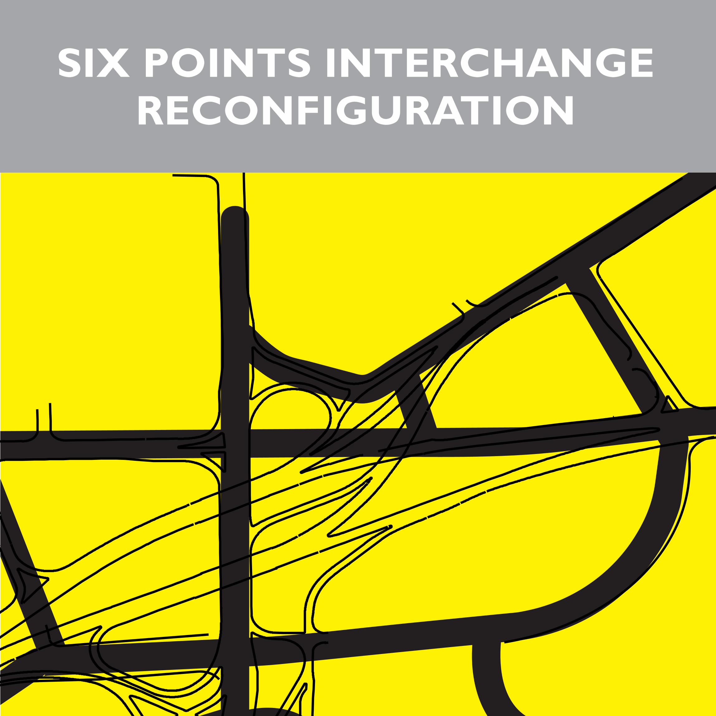
A NEW ETOBICOKE CENTRERECONSTRUCTING THE SIX POINTS INTERCHANGE
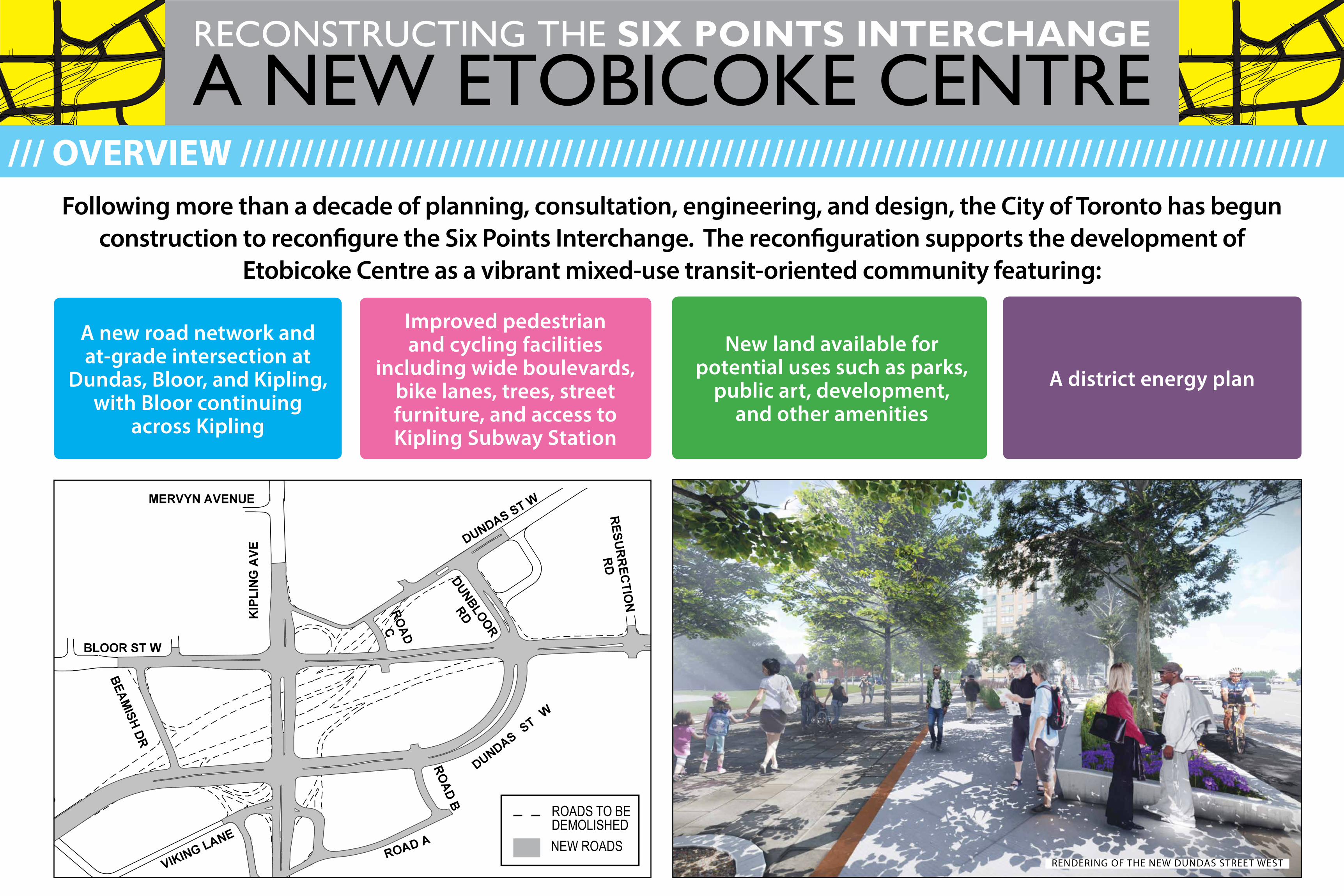
Following more than a decade of planning, consultation, engineering, and design, the City of Toronto has begun construction to reconfigure the Six Points Interchange. The reconfiguration supports the development of
Etobicoke Centre as a vibrant mixed-use transit-oriented community featuring:
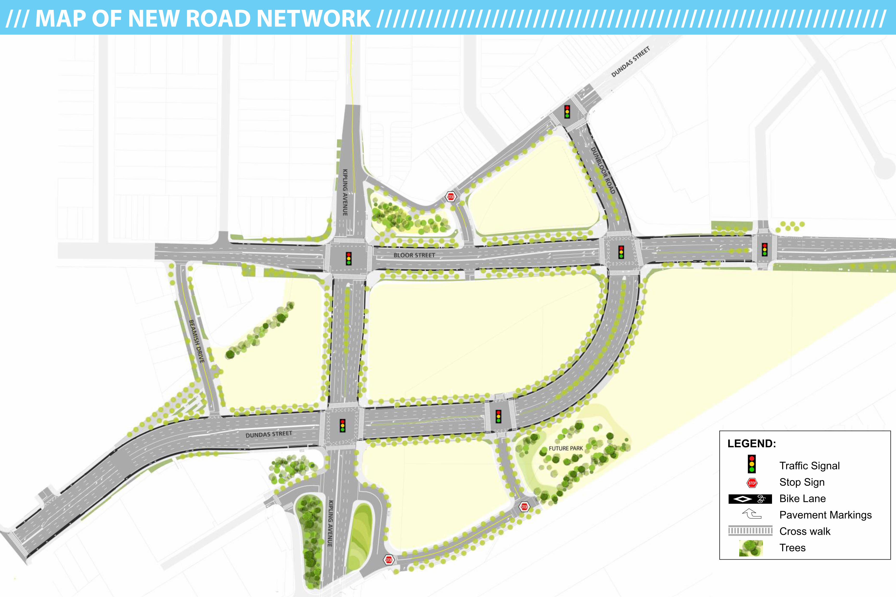
A new road network and at-grade intersection at
Dundas, Bloor, and Kipling, with Bloor continuing
across Kipling
Improved pedestrian and cycling facilities
including wide boulevards, bike lanes, trees, street furniture, and access to Kipling Subway Station
New land available for potential uses such as parks,
public art, development, and other amenities
A district energy plan
ROADS TO BE DEMOLISHEDNEW ROADS
/// OVERVIEW ////////////////////////////////////////////////////////////////////////////////////////
RENDERING OF THE NEW DUNDAS STREET WEST
A NEW ETOBICOKE CENTRERECONSTRUCTING THE SIX POINTS INTERCHANGE
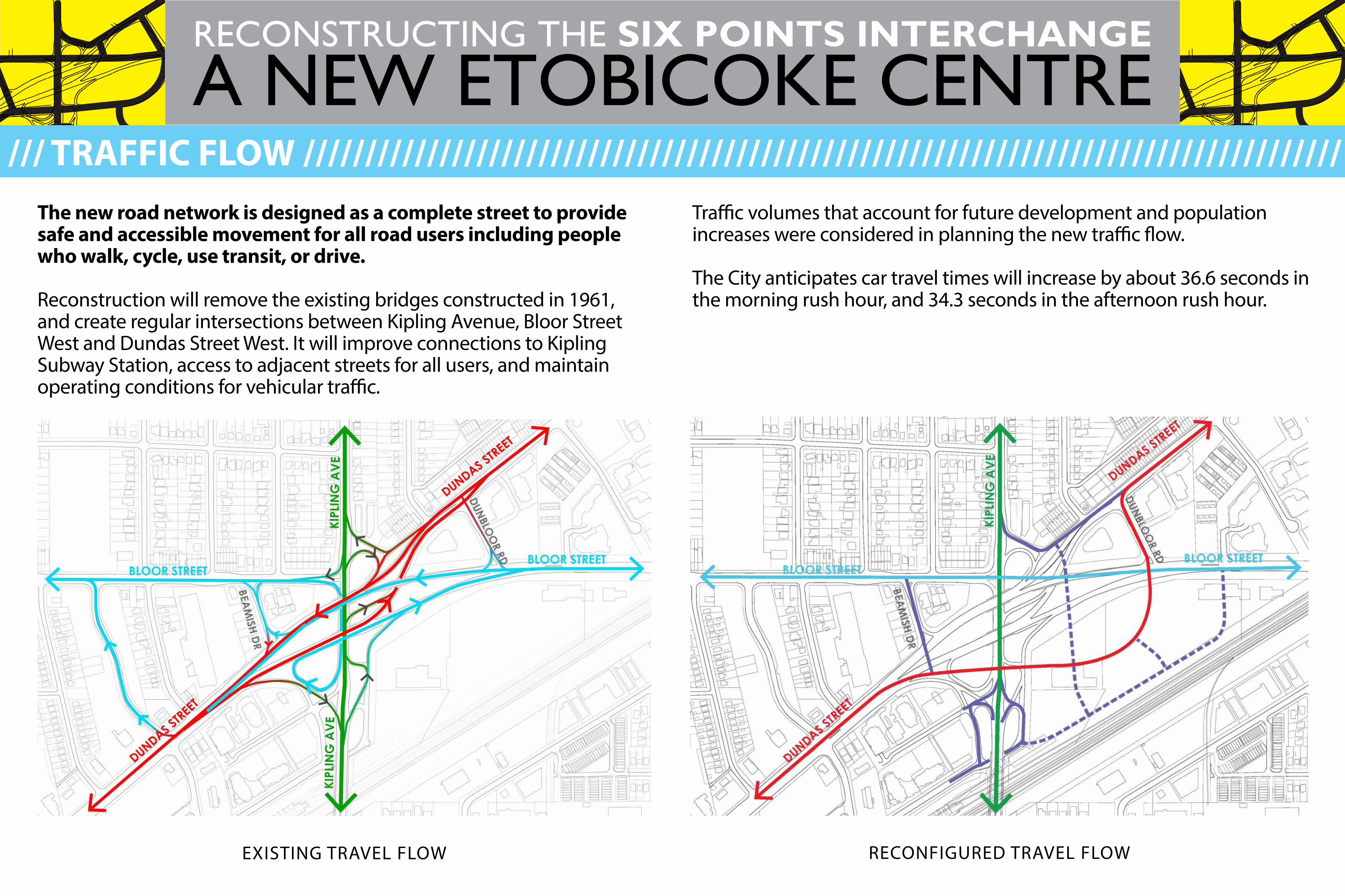
The new road network is designed as a complete street to provide safe and accessible movement for all road users including people who walk, cycle, use transit, or drive.
Reconstruction will remove the existing bridges constructed in 1961, and create regular intersections between Kipling Avenue, Bloor Street West and Dundas Street West. It will improve connections to Kipling Subway Station, access to adjacent streets for all users, and maintain operating conditions for vehicular traffic.
Traffic volumes that account for future development and population increases were considered in planning the new traffic flow.
The City anticipates car travel times will increase by about 36.6 seconds in the morning rush hour, and 34.3 seconds in the afternoon rush hour.
EXISTING TRAVEL FLOW RECONFIGURED TRAVEL FLOW
/// TRAFFIC FLOW ////////////////////////////////////////////////////////////////////////////////////
A NEW ETOBICOKE CENTRERECONSTRUCTING THE SIX POINTS INTERCHANGE
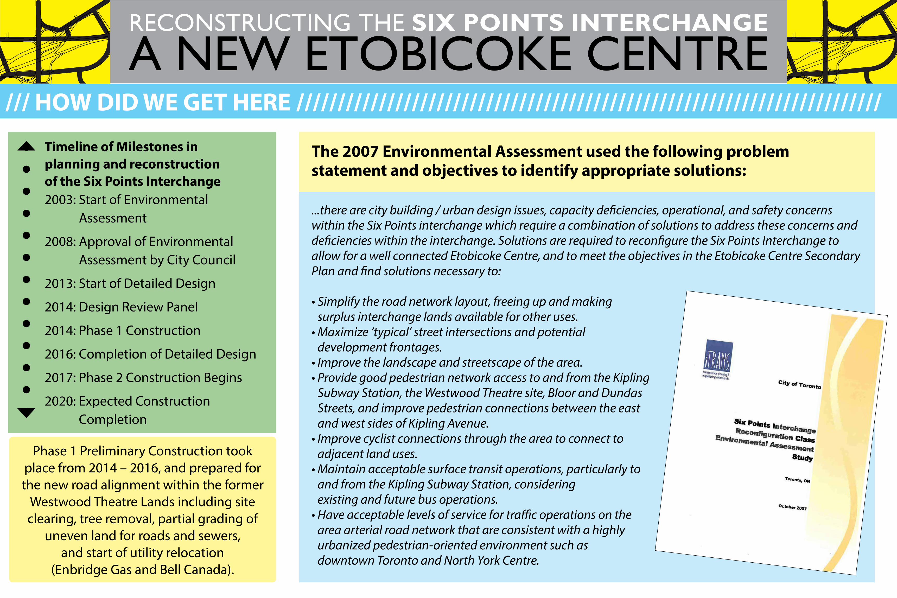
Timeline of Milestones in planning and reconstruction of the Six Points Interchange 2003: Start of Environmental
Assessment 2008: Approval of Environmental
Assessment by City Council 2013: Start of Detailed Design 2014: Design Review Panel 2014: Phase 1 Construction 2016: Completion of Detailed Design
2017: Phase 2 Construction Begins 2020: Expected Construction
Completion
The 2007 Environmental Assessment used the following problem statement and objectives to identify appropriate solutions:
/// HOW DID WE GET HERE ///////////////////////////////////////////////////////////////////////
...there are city building / urban design issues, capacity deficiencies, operational, and safety concerns within the Six Points interchange which require a combination of solutions to address these concerns and deficiencies within the interchange. Solutions are required to reconfigure the Six Points Interchange to allow for a well connected Etobicoke Centre, and to meet the objectives in the Etobicoke Centre Secondary Plan and find solutions necessary to:
• Simplify the road network layout, freeing up and making surplus interchange lands available for other uses.
• Maximize ‘typical’ street intersections and potential development frontages.
• Improve the landscape and streetscape of the area.• Provide good pedestrian network access to and from the Kipling
Subway Station, the Westwood Theatre site, Bloor and Dundas Streets, and improve pedestrian connections between the east and west sides of Kipling Avenue.
• Improve cyclist connections through the area to connect to adjacent land uses.
• Maintain acceptable surface transit operations, particularly to and from the Kipling Subway Station, considering existing and future bus operations.
• Have acceptable levels of service for traffic operations on the area arterial road network that are consistent with a highly urbanized pedestrian-oriented environment such as downtown Toronto and North York Centre.
Phase 1 Preliminary Construction took place from 2014 – 2016, and prepared for the new road alignment within the former
Westwood Theatre Lands including site clearing, tree removal, partial grading of
uneven land for roads and sewers, and start of utility relocation
(Enbridge Gas and Bell Canada).
A NEW ETOBICOKE CENTRERECONSTRUCTING THE SIX POINTS INTERCHANGE
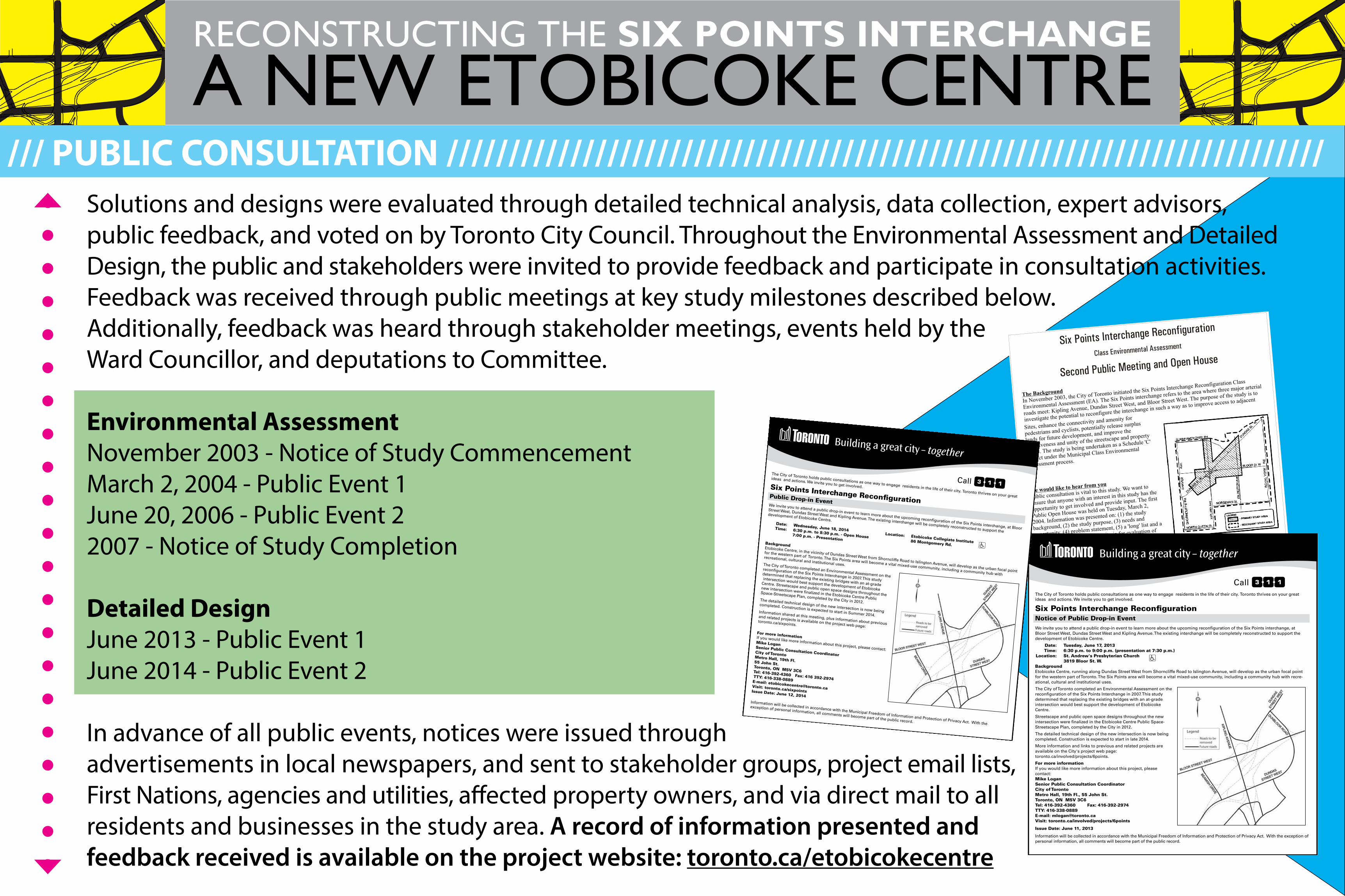
Solutions and designs were evaluated through detailed technical analysis, data collection, expert advisors, public feedback, and voted on by Toronto City Council. Throughout the Environmental Assessment and Detailed Design, the public and stakeholders were invited to provide feedback and participate in consultation activities. Feedback was received through public meetings at key study milestones described below. Additionally, feedback was heard through stakeholder meetings, events held by the Ward Councillor, and deputations to Committee.
Environmental AssessmentNovember 2003 - Notice of Study CommencementMarch 2, 2004 - Public Event 1June 20, 2006 - Public Event 22007 - Notice of Study Completion
Detailed DesignJune 2013 - Public Event 1June 2014 - Public Event 2
In advance of all public events, notices were issued through advertisements in local newspapers, and sent to stakeholder groups, project email lists, First Nations, agencies and utilities, affected property owners, and via direct mail to all residents and businesses in the study area. A record of information presented and feedback received is available on the project website: toronto.ca/etobicokecentre
/// PUBLIC CONSULTATION ///////////////////////////////////////////////////////////////////////
The City of Toronto holds public consultations as one way to engage residents in the life of their city. Toronto thrives on your great ideas and actions. We invite you to get involved.
Six Points Interchange Recon�gurationNotice of Public Drop-in EventWe invite you to attend a public drop-in event to learn more about the upcoming recon�guration of the Six Points interchange, at Bloor Street West, Dundas Street West and Kipling Avenue. The existing interchange will be completely reconstructed to support the development of Etobicoke Centre.
Date: Tuesday, June 17, 2013 Time: 6:30 p.m. to 9:00 p.m. (presentation at 7:30 p.m.) Location: St. Andrew's Presbyterian Church 3819 Bloor St. W.BackgroundEtobicoke Centre, running along Dundas Street West from Shorncliffe Road to Islington Avenue, will develop as the urban focal point for the western part of Toronto. The Six Points area will become a vital mixed-use community, including a community hub with recre-ational, cultural and institutional uses.
The City of Toronto completed an Environmental Assessment on the recon�guration of the Six Points Interchange in 2007. This study determined that replacing the existing bridges with an at-grade intersection would best support the development of Etobicoke Centre.
Streetscape and public open space designs throughout the new intersection were �nalized in the Etobicoke Centre Public Space-Streetscape Plan, completed by the City in 2012.
The detailed technical design of the new intersection is now being completed. Construction is expected to start in late 2014.
More information and links to previous and related projects are available on the City's project web page: toronto.ca/involved/projects/6points.
For more informationIf you would like more information about this project, please contact:Mike LoganSenior Public Consultation CoordinatorCity of Toronto Metro Hall, 19th Fl., 55 John St.Toronto, ON M5V 3C6Tel: 416-392-4360 Fax: 416-392-2974TTY: 416-338-0889E-mail: [email protected]: toronto.ca/involved/projects/6points
Issue Date: June 11, 2013
Information will be collected in accordance with the Municipal Freedom of Information and Protection of Privacy Act. With the exception of personal information, all comments will become part of the public record.
The City of Toronto holds public consultations as one way to engage residents in the life of their city. Toronto thrives on your great
ideas and actions. We invite you to get involved.Six Points Interchange Recon�gurationPublic Drop-in EventWe invite you to attend a public drop-in event to learn more about the upcoming recon�guration of the Six Points interchange, at Bloor
Street West, Dundas Street West and Kipling Avenue. The existing interchange will be completely reconstructed to support the
development of Etobicoke Centre. Date: Wednesday, June 18, 2014 Time: 6:30 p.m. to 8:30 p.m. - Open House 7:00 p.m. - PresentationBackgroundEtobicoke Centre, in the vicinity of Dundas Street West from Shorncliffe Road to Islington Avenue, will develop as the urban focal point
for the western part of Toronto. The Six Points area will become a vital mixed-use community, including a community hub with
recreational, cultural and institutional uses.The City of Toronto completed an Environmental Assessment on the
recon�guration of the Six Points Interchange in 2007. This study
determined that replacing the existing bridges with an at-grade
intersection would best support the development of Etobicoke
Centre. Streetscape and public open space designs throughout the
new intersection were �nalized in the Etobicoke Centre Public Space-Streetscape Plan, completed by the City in 2012.The detailed technical design of the new intersection is now being
completed. Construction is expected to start in Summer 2014.Information shared at this meeting, plus information about previous
and related projects is available on the project web page: toronto.ca/sixpoints.
For more informationIf you would like more information about this project, please contact:
Mike LoganSenior Public Consultation Coordinator City of Toronto Metro Hall, 19th Fl.55 John St.
Toronto, ON M5V 3C6Tel: 416-392-4360 Fax: 416 392-2974 TTY: 416-338-0889E-mail: [email protected]: toronto.ca/sixpointsIssue Date: June 12, 2014Information will be collected in accordance with the Municipal Freedom of Information and Protection of Privacy Act. With the
exception of personal information, all comments will become part of the public record.
Location: Etobicoke Collegiate Institute 86 Montgomery Rd.
/// MAP OF NEW ROAD NETWORK //////////////////////////////////////////////////////////////
STOP
Traffic Signal
Stop Sign
Bike Lane
Pavement Markings
Cross walk
Trees
LEGEND:
STOP
Traffic Signal
Stop Sign
Bike Lane
Pavement Markings
Cross walk
Trees
LEGEND:
A NEW ETOBICOKE CENTRERECONSTRUCTING THE SIX POINTS INTERCHANGE
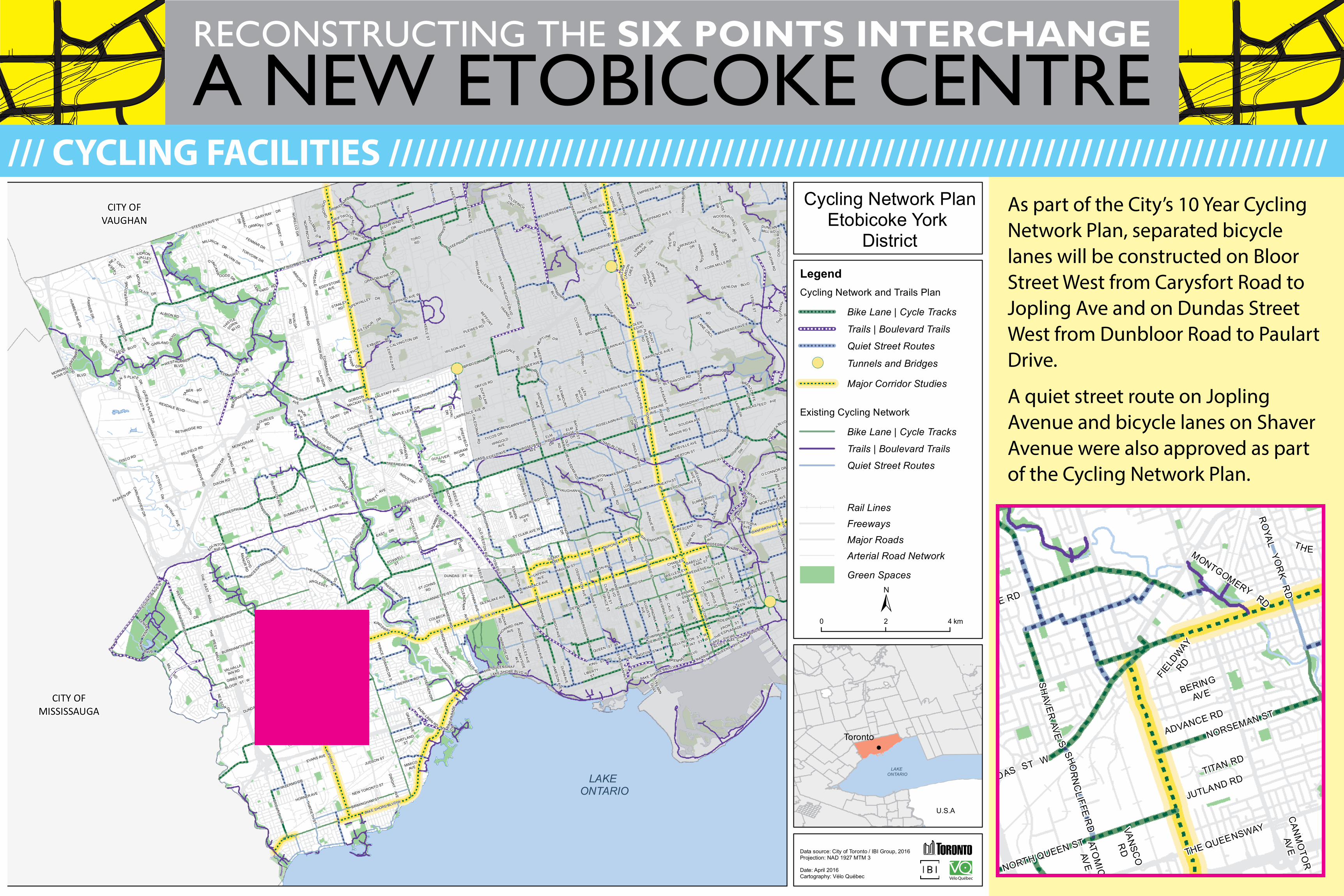
As part of the City’s 10 Year Cycling Network Plan, separated bicycle lanes will be constructed on Bloor Street West from Carysfort Road to Jopling Ave and on Dundas Street West from Dunbloor Road to Paulart Drive.
A quiet street route on Jopling Avenue and bicycle lanes on Shaver Avenue were also approved as part of the Cycling Network Plan.
CITY OFMISSISSAUGA
CITY OFBRAMPTON
CITY OFVAUGHAN
QUEEN ST E
LEDBUR
YS
T
HEATH ST W
HARBORD ST
BAY
VIE
W AV
E
BARTON AVE
SHUTER ST
CA
RLA
WAVE
LOG
AN AVE
LAIRD
DR
BATH
UR
ST
ST
SPADIN
A AV
E
BREM NERBLVD
DUNDAS ST E
YO
NG
E S
T
DIXON RD
RO
YAL
YOR
KR
D
DUNDAS ST W
OS
SING
TON
AV E
VAUGHAN RD
HIG
HW
AY27
N
AD ELAIDE STE
KE
ELE
ST
GARY DR
DU
FFERIN
ST
RU
NN
YMED
E RD
OSLE
RS
T
ROGERS RD
STEPHEN
DR
VARNA
DR
STEELES AVE W
BLOOR ST W
ISABELLA ST
THE
EAST
MA
LL
KEELE ST
KENN
ETH AVE
FAIRLAWN AVE
CH
UR
CH
ST
EI REAN
N
QU
AY
MA
RLEE AV
E
SCARLETTR
D
OVE
RLEA
BLVD
CARLTON ST
WELLINGTON ST W
ST CLAIR AVE W
SHAW
ST
GILTS PUR
DR
AVEN
UE
RD
EGLINTON AVE W
FINCH AVE W
ALBION RD
WEN
DELL
AVE
LES
LIE S
T
CH
RISTIE ST
KIPLIN
GAVE
EMPRESS AVE
DO
RIS AVE
LAKE SHORE BLVD W
MILLWOOD RD
KING ST W
RO
SEMOUNTAVE
SENLAC
RD
LAKE SHORE BLVD W
JAN
E S
T
MA
RTIN G
RO
VE RD
CHAPLIN CRES
LAKE SHORE BLVD W
KIPLING
AVE
LAWRENCE AVE W
WELLINGTON ST W
GLENGROVE AVE W
ISLING
TON
AVE
BELFIELD RD
DO
VERC
OU
RT
RD
HU
MBER
COL LEGE BLVD
MAPLE LEAF DR
GLENLAKE AVE
PAR
KSIDE D
R
DANFORTH AVE
ALNESS
ST
EVANS AVE
SOU
THKINGSW
AY
DUPONT ST
HEATH ST
E
BLOOR ST W
QU
EE
N S PLATE DR
STR
AC
HA
NAV
E
YORK MILLS RD
HIG
HW
AY 27 S
ANNETTE ST
SE
NTI N
EL
RD
COLBECK
ST
THE QUEENSWAY
THE WESTWAY
WESTON RD
ADELAIDE ST W
QUEENS QUAY E
RO
CKC
LIFFE BLVD
WELLESLEY
ST W
OAK
WO
OD
AVE
SHEPPARD AVE W
THE QUEENSWAY
THE POND RD
DAVENPORT RD
WILSON AVE
RATHBURN RD
QUEEN ST W
RANEE AVE
ELLISAVE
REXDALE BLVD
BROOKE AVE
OLD
WE
STON
RD
DUNDAS ST W
LEXFIELD
AVE
DU
FFER
INS
T
MILL
RD
COLLEGE ST
JAMESO
N AVE
WALLACE AVE
GLEN CAIRN AVE
MORTIMER AVE
RUSTIC RD
LAWRENCE AVE E
DAVISVILLE AVE
BURNHAMTHORPE RD
DO
NM
ILLS
RD
UN
IVER
SITY
AVE
SHER
BOU
RN
EST
TRANSITR
D
EGLI
NTON
AVE
W
MOORE AVE
DRIFTWOODAVE
EGLINTON AVE E
CRES CENT RD
WILM
ING
TON
AVE
GR
ACE ST
RICHMOND ST W
SILVERTH
OR
NA
VE
PARKLAW
NRD
LAWRENCE AVE E
LAKE SHORE
BLVD E
BRO
CK AVE
JARVIS ST
TRETHEWEY DR
LAKE SHORE BLVD E
WESTHUMBER
BLVD
JOH
N GARLAN D
BLVD
DUNCAN
W
O ODS DR
ST CLAIR AVE E
DU
PLEX
AVE
BEVERLE
Y S
T
THISTLE
DOWN
BLVD
CHARLES
ST W
BLYTHWOOD RD
HOWARD PARK
AVE
VICTO
RIA
ST
FASKEN DR
BETHRIDGE RD
MIMICO
AVE
LAN
SDO
WN
EAV
E
ROSELAWN AVE
MORNING
STAR DR
KILBARRY RD
CHURCH ST
SHEPPARD AVE E
DAV EN PORT RD
KEELE ST
CA
LED
ON
IAR
D
WELLESLEY ST E
O CONNOR DR
AU
GU
STA
AVE
DISCO RD
BR
OW
NS
LINE
TAM
WO
RTH
RD
DU
NN
AVE
CU
LFOR
DR
D
EARL ST
MILL ST
HOPEST
GO
SFO
RD
BLVD
MANOR RD E
BANNATYNE
DR
DUNC ANMILL RD
ELM R
D
MC
C
AUL
ST
NEW TORONTO ST
WALSHAVE
OLD
PAR
KR
D
NAIR
N
AVE
PR
OV
OS
T
DR
ELM ST
THIR
TIETH ST
LAPPIN
AVE
SH
AVE
RAV
ES
SUN
NYSID
E
AVE
MO
U NT
OLIVE DR
FRONT ST E
FRONT ST W
LAN
YARD RD
SHOR EHAM
DR
AVONDALE AVE
BRENTCLIFFE
RD
SYMIN
GTO
N AVE
HALLAM ST
PRETORIAAVE
FAYW
OO
DBLV
D
SPADIN
A R
D
BE
ECR
OFT
RD
STANLEY
RD
BERRY RD
YONGEBLVD
WIN
COTT
DR
VAN
SCO
RD
INGRAM
DR
FLORENCE AVE
BLACK
CRE
EK
DR
CLEN
DEN
AN
AVE
CLIN
TON
ST
ST JOHNS
RD
KIDRONVALLEY
DR
ROSEDALE VALLEY RD
BICKN
ELL AVE
NORSEMAN ST
EDITH
DR
ARM
OUR
BLV
D
CAR
LING
VIEW D
R
VARSITYRD
PORTLAND
ST
FENNAVE
WILSO
NH
EIG
HTS
BLVD
GERRARD
ST W
MERTON ST
FENMAR DR
SUMMERHILL
AVE
P RIN
CESS
MARGARETBLV
D
PRIN
CE
EDW
AR
D D
R S
ROSELAWN
AVE
HARBOUR
ST
CHA
LKFA
R
M D R
BERING
AVE
GLEN
ECHORD
THE ESPLANADE
BROADWAY AVE
SUMMITCREST DR
ADVANCE RD
DEWSON
ST
DENLO W BLVD
THE KINGSWAY
ST GEO
RG
E ST
GRANDRAVINE DR
HU
MB
ER
LINE
DR
CHERRY
ST
ATTWE
LLD
R
PINE ST
JUDSON ST
BA
RTO
R R
D
SHOR
NC
LIFFER
D
BEFFORT
RD
FLINT
RD
LIBERTY
ST
WIN
DE
RM
ERE
AVE
LA ROSE AVE
YORKDALE
RD
MONTGOMERYRD
ELMH URST DR
HA
RR
I SONR
D
ANGLESEY BLVD
BIRMINGHAM ST
FOXWELL
ST
G
UN
NS
RD
OVERBROOK PL
WILLO
WD
ALE AVE
ELMAVE
WOODSWORTH
R
D
ELM
RIDGE
DR
DU
VAL
DR
GLE
NC
EDAR
RD
SOUDAN AVE
NE
ILSO
NDR
MO
UN
T
PLEA
SAN
T
RD
EXBURYRD
BURTONRD
LLOYD
MA
NO
RR
D
F IFE
SHI
RE
RD BAN
BU
RY
RD
CASTLEFIELD AVE
SHER
MO
UN
T
AVE
FALSTAFF AVE
GLE
NM
OU
NT
AVE
VALERMO DR
KNOBHILLD
R
AMEER
AVE
CLYD
E AVE
GEARY
AVE
RED
PATH AVE
ORMON T DR
SPENVALLEY DR
WE
LLAN
D
AVE
SOUTHVALE
DR
UPJO
HN
RD
CAN
MO
TOR
AVE
IND
IAN
RD
HA
WK
SB
UR
Y DR
BE
RKINDALE
DR
SIGN
ET
DR
CENTENNIAL
PAR
K
B LVD
EDE
NBR
ID
GE
DR
WICKST EED AVE
LONSDALE
RD
GORDON
MACKAY RD
ELM
RIDGEDR
PALM
ERSTO
N
BLVD
RE
SOURCES
RD
ORFUS RD
TORORD
NEP
TUNE D R
INDUSTRY ST
BRIDGELANDAVE
GIBBS RD
FOUR WINDS
DR
PO
TTERY
RD
EG
LINTONAVE W
CH
ESSWO
OD
DR
GU LLI VERR D
STEEPROCK DR
WIN
ON
A
DR
PARK HOME AVE
VALHALLA
INN RD
BARM
AC
DR
TOBERMORYDR
QUEE
NS
PLATED
R
DU
FFLAW
RDTA
BER RD
GARYRAY DRELLERSLIE AVE
PLEWES RD
ERSKINE
AVE
GO
LDFINCHCRT
POST RD
EAST DR
TAN
GIE
RS
RD
RACINE RD
HIG
HPAR
KAV
E
WIL
LIA
MC
ARS
ON
CRE
S
CLAYSO
N
RD
JUTLAND RD
TYCOS DR
MONOGRAM
PL
LESMILL
R
D
ATOM
IC
AVE
WINGOLD
AVE
TORYORK DR
RIVA
LDA
RD
TITAN RD
PARK
LANE CRCL
EDDYSTONE
AVE
MO
UN
TPLE
ASAN
TR
D
SOR
AUR
EN AVE
PAR
LIAMEN
T S
T
BRO
ADVIEW
AVE
BAY
S
T
RE
NFO
RTHD
R
SPADIN
A R
D
CA
RR
IERD
R
RO
NC
ESVALLES AVE
CH
ER
RY
ST
NORTH QUEEN ST
OR
IOLE
PKW
Y
M A RIN
EPA
RAD
ED
R
PAPE AV
E
HUM
BERW
OOD
BLVD
DW
IGH
T AVE
BLOOR
RAM
P
THE
WES
TM
ALL
WE
LLESW
ORTH
DR
SIL
VE
RST
ON
E
DR
CA
BERNET CR
C L
PARK
RDAV
ENU
E RD
THE KINGSWAY
GLEN
RUS
HBLV
D
EMME T T
AVE
HU
MBE
RBL
VD
NO
RFIN
CH
DR
ARROWRD
AR
RO
W R
D
WES
TMO
RE D
R
HU
LLMAR
DR
TH
ED
ONW
AY
W
CALVINGTON DR
BANBURYRD
BROO
KH
AVE
ND
R
HORNER AVE
GLE
N R
D
GR
AND
AVE
UPPER
HIG
HLAN
D
CR
ES
SH
EFFIELD
ST
FIELD
WAY
RD
UPPER
CANADA
DRMILLWICKDR
BERG
AMOT AVE
WILLIA
MR
ALLEN RD
OAK
DA
LER
D
MILVAN DR
TOR
BAR
RIE
RD
SKYWAY
AVE
RONSO
NDR
NO
RE
LCO
DR
LAKE ONTARIO
±
Data source: City of Toronto / IBI Group, 2016Projection: NAD 1927 MTM 3
Date: April 2016Cartography: Vélo Québec
0 2 4 km
!
Toronto
U.S.A
LAKE ONTARIO
Cycling Network PlanEtobicoke York
District
LegendCycling Network and Trails Plan
Existing Cycling Network
FreewaysMajor RoadsArterial Road Network
Green Spaces
Rail Lines
Major Corridor Studies
Trails | Boulevard Trails
Trails | Boulevard Trails
Quiet Street Routes
Bike Lane | Cycle Tracks
Quiet Street Routes
Bike Lane | Cycle Tracks
Tunnels and Bridges!(
CITY OFMISSISSAUGA
CITY OFBRAMPTON
CITY OFVAUGHAN
QUEEN ST E
LEDBUR
YS
T
HEATH ST W
HARBORD ST
BAY
VIE
W AV
E
BARTON AVE
SHUTER ST
CA
RLA
WAVE
LOG
AN AVE
LAIRD
DR
BATH
UR
ST
ST
SPADIN
A AV
E
BREM NERBLVD
DUNDAS ST E
YO
NG
E S
T
DIXON RD
RO
YAL
YOR
KR
D
DUNDAS ST W
OS
SING
TON
AV E
VAUGHAN RD
HIG
HW
AY27
N
AD ELAIDE STE
KE
ELE
ST
GARY DR
DU
FFERIN
ST
RU
NN
YMED
E RD
OSLE
RS
T
ROGERS RD
STEPHEN
DR
VARNA
DR
STEELES AVE W
BLOOR ST W
ISABELLA ST
THE
EAST
MA
LL
KEELE ST
KENN
ETH AVE
FAIRLAWN AVE
CH
UR
CH
ST
EI REAN
N
QU
AY
MA
RLEE AV
E
SCARLETTR
D
OVE
RLEA
BLVD
CARLTON ST
WELLINGTON ST W
ST CLAIR AVE W
SHAW
ST
GILTS PUR
DR
AVEN
UE
RD
EGLINTON AVE W
FINCH AVE W
ALBION RD
WEN
DELL
AVE
LES
LIE S
T
CH
RISTIE ST
KIPLIN
GAVE
EMPRESS AVED
OR
IS AVE
LAKE SHORE BLVD W
MILLWOOD RD
KING ST W
RO
SEMOUNTAVE
SENLAC
RD
LAKE SHORE BLVD W
JAN
E S
T
MA
RTIN G
RO
VE RD
CHAPLIN CRES
LAKE SHORE BLVD W
KIPLING
AVE
LAWRENCE AVE W
WELLINGTON ST W
GLENGROVE AVE W
ISLING
TON
AVE
BELFIELD RD
DO
VERC
OU
RT
RD
HU
MBER
COL LEGE BLVD
MAPLE LEAF DR
GLENLAKE AVE
PAR
KSIDE D
R
DANFORTH AVE
ALNESS
ST
EVANS AVE
SOU
THKINGSW
AY
DUPONT ST
HEATH ST
E
BLOOR ST W
QU
EE
N S PLATE DR
STR
AC
HA
NAV
E
YORK MILLS RD
HIG
HW
AY 27 S
ANNETTE ST
SE
NTI N
EL
RD
COLBECK
ST
THE QUEENSWAY
THE WESTWAY
WESTON RD
ADELAIDE ST W
QUEENS QUAY E
RO
CKC
LIFFE BLVD
WELLESLEY
ST W
OAK
WO
OD
AVE
SHEPPARD AVE W
THE QUEENSWAY
THE POND RD
DAVENPORT RD
WILSON AVE
RATHBURN RD
QUEEN ST W
RANEE AVE
ELLISAVE
REXDALE BLVD
BROOKE AVE
OLD
WE
STON
RD
DUNDAS ST W
LEXFIELD
AVE
DU
FFER
INS
T
MILL
RD
COLLEGE ST
JAMESO
N AVE
WALLACE AVE
GLEN CAIRN AVE
MORTIMER AVE
RUSTIC RD
LAWRENCE AVE E
DAVISVILLE AVE
BURNHAMTHORPE RD
DO
NM
ILLS
RD
UN
IVER
SITY
AVE
SHER
BOU
RN
EST
TRANSITR
D
EGLI
NTON
AVE
W
MOORE AVE
DRIFTWOODAVE
EGLINTON AVE E
CRES CENT RD
WILM
ING
TON
AVE
GR
ACE ST
RICHMOND ST W
SILVERTH
OR
NA
VE
PARKLAW
NRD
LAWRENCE AVE E
LAKE SHORE
BLVD E
BRO
CK AVE
JARVIS ST
TRETHEWEY DR
LAKE SHORE BLVD E
WESTHUMBER
BLVD
JOH
N GARLAN D
BLVD
DUNCAN
W
O ODS DR
ST CLAIR AVE E
DU
PLEX
AVE
BEVERLE
Y S
T
THISTLE
DOWN
BLVD
CHARLES
ST W
BLYTHWOOD RD
HOWARD PARK
AVE
VICTO
RIA
ST
FASKEN DR
BETHRIDGE RD
MIMICO
AVE
LAN
SDO
WN
EAV
E
ROSELAWN AVE
MORNING
STAR DR
KILBARRY RD
CHURCH ST
SHEPPARD AVE E
DAV EN PORT RD
KEELE ST
CA
LED
ON
IAR
D
WELLESLEY ST E
O CONNOR DR
AU
GU
STA
AVE
DISCO RD
BR
OW
NS
LINE
TAM
WO
RTH
RD
DU
NN
AVE
CU
LFOR
DR
D
EARL ST
MILL ST
HOPEST
GO
SFO
RD
BLVD
MANOR RD E
BANNATYNE
DR
DUNC ANMILL RD
ELM R
D
MC
C
AUL
ST
NEW TORONTO ST
WALSHAVE
OLD
PAR
KR
D
NAIR
N
AVE
PR
OV
OS
T
DR
ELM ST
THIR
TIETH ST
LAPPIN
AVE
SH
AVE
RAV
ES
SUN
NYSID
E
AVE
MO
U NT
OLIVE DR
FRONT ST E
FRONT ST W
LAN
YARD RD
SHOR EHAM
DR
AVONDALE AVE
BRENTCLIFFE
RD
SYMIN
GTO
N AVE
HALLAM ST
PRETORIAAVE
FAYW
OO
DBLV
D
SPADIN
A R
D
BE
ECR
OFT
RD
STANLEY
RD
BERRY RD
YONGEBLVD
WIN
COTT
DR
VAN
SCO
RD
INGRAM
DR
FLORENCE AVE
BLACK
CRE
EK
DR
CLEN
DEN
AN
AVE
CLIN
TON
ST
ST JOHNS
RD
KIDRONVALLEY
DR
ROSEDALE VALLEY RD
BICKN
ELL AVE
NORSEMAN ST
EDITH
DR
ARM
OUR
BLV
D
CAR
LING
VIEW D
R
VARSITYRD
PORTLAND
ST
FENNAVE
WILSO
NH
EIG
HTS
BLVD
GERRARD
ST W
MERTON ST
FENMAR DR
SUMMERHILL
AVE
P RIN
CESS
MARGARETBLV
D
PRIN
CE
EDW
AR
D D
R S
ROSELAWN
AVE
HARBOUR
ST
CHA
LKFA
R
M D R
BERING
AVE
GLEN
ECHORD
THE ESPLANADE
BROADWAY AVE
SUMMITCREST DR
ADVANCE RD
DEWSON
ST
DENLO W BLVD
THE KINGSWAY
ST GEO
RG
E ST
GRANDRAVINE DR
HU
MB
ER
LINE
DR
CHERRY
ST
ATTWE
LLD
R
PINE ST
JUDSON ST
BA
RTO
R R
D
SHOR
NC
LIFFER
D
BEFFORT
RD
FLINT
RD
LIBERTY
ST
WIN
DE
RM
ERE
AVE
LA ROSE AVE
YORKDALE
RD
MONTGOMERYRD
ELMH URST DR
HA
RR
I SONR
D
ANGLESEY BLVD
BIRMINGHAM ST
FOXWELL
ST
G
UN
NS
RD
OVERBROOK PL
WILLO
WD
ALE AVE
ELMAVE
WOODSWORTH
R
D
ELM
RIDGE
DR
DU
VAL
DR
GLE
NC
EDAR
RD
SOUDAN AVE
NE
ILSO
NDR
MO
UN
T
PLEA
SAN
T
RD
EXBURYRD
BURTONRD
LLOYD
MA
NO
RR
D
F IFE
SHI
RE
RD BAN
BU
RY
RD
CASTLEFIELD AVE
SHER
MO
UN
T
AVE
FALSTAFF AVE
GLE
NM
OU
NT
AVE
VALERMO DR
KNOBHILLD
R
AMEER
AVE
CLYD
E AVE
GEARY
AVE
RED
PATH AVE
ORMON T DR
SPENVALLEY DR
WE
LLAN
D
AVE
SOUTHVALE
DR
UPJO
HN
RD
CAN
MO
TOR
AVE
IND
IAN
RD
HA
WK
SB
UR
Y DR
BE
RKINDALE
DR
SIGN
ET
DR
CENTENNIAL
PAR
KB LVD
EDE
NBR
ID
GE
DR
WICKST EED AVE
LONSDALE
RD
GORDON
MACKAY RD
ELM
RIDGEDR
PALM
ERSTO
N
BLVD
RE
SOURCES
RD
ORFUS RD
TORORD
NEP
TUNE D R
INDUSTRY ST
BRIDGELANDAVE
GIBBS RD
FOUR WINDS
DR
PO
TTERY
RD
EG
LINTONAVE W
CH
ESSWO
OD
DR
GU LLI VERR D
STEEPROCK DRW
INO
NA
DR
PARK HOME AVE
VALHALLA
INN RD
BARM
AC
DR
TOBERMORYDR
QUEE
NS
PLATED
R
DU
FFLAW
RDTA
BER RD
GARYRAY DRELLERSLIE AVE
PLEWES RD
ERSKINE
AVE
GO
LDFINCHCRT
POST RD
EAST DR
TAN
GIE
RS
RD
RACINE RD
HIG
HPAR
KAV
E
WIL
LIA
MC
ARS
ON
CRE
S
CLAYSO
N
RD
JUTLAND RD
TYCOS DR
MONOGRAM
PL
LESMILL
R
D
ATOM
IC
AVE
WINGOLD
AVE
TORYORK DR
RIVA
LDA
RD
TITAN RD
PARK
LANE CRCL
EDDYSTONE
AVE
MO
UN
TPLE
ASAN
TR
D
SOR
AUR
EN AVE
PAR
LIAMEN
T S
T
BRO
ADVIEW
AVE
BAY
S
TR
EN
FORTH
DR
SPADIN
A R
D
CA
RR
IERD
R
RO
NC
ESVALLES AVE
CH
ER
RY
ST
NORTH QUEEN ST
OR
IOLE
PKW
Y
M A RIN
EPA
RAD
ED
R
PAPE AV
E
HUM
BERW
OOD
BLVD
DW
IGH
T AVE
BLOOR
RAM
P
THE
WES
TM
ALL
WE
LLESW
ORTH
DR
SIL
VE
RST
ON
E
DR
CA
BERNET CR
C L
PARK
RD
AVEN
UE R
D
THE KINGSWAY
GLEN
RUS
HBLV
D
EMME T T
AVE
HU
MBE
RBL
VD
NO
RFIN
CH
DR
ARROWRD
AR
RO
W R
D
WES
TMO
RE D
R
HU
LLMAR
DR
TH
ED
ONW
AY
W
CALVINGTON DR
BANBURYRD
BROO
KH
AVE
ND
R
HORNER AVE
GLE
N R
D
GR
AND
AVE
UPPER
HIG
HLAN
D
CR
ES
SH
EFFIELD
ST
FIELD
WAY
RD
UPPER
CANADA
DRMILLWICKDR
BERG
AMOT AVE
WILLIA
MR
ALLEN RD
OAK
DA
LER
D
MILVAN DR
TOR
BAR
RIE
RD
SKYWAY
AVE
RONSO
NDR
NO
RE
LCO
DR
LAKE ONTARIO
±
Data source: City of Toronto / IBI Group, 2016Projection: NAD 1927 MTM 3
Date: April 2016Cartography: Vélo Québec
0 2 4 km
!
Toronto
U.S.A
LAKE ONTARIO
Cycling Network PlanEtobicoke York
District
LegendCycling Network and Trails Plan
Existing Cycling Network
FreewaysMajor RoadsArterial Road Network
Green Spaces
Rail Lines
Major Corridor Studies
Trails | Boulevard Trails
Trails | Boulevard Trails
Quiet Street Routes
Bike Lane | Cycle Tracks
Quiet Street Routes
Bike Lane | Cycle Tracks
Tunnels and Bridges!(
/// CYCLING FACILITIES ////////////////////////////////////////////////////////////////////////////
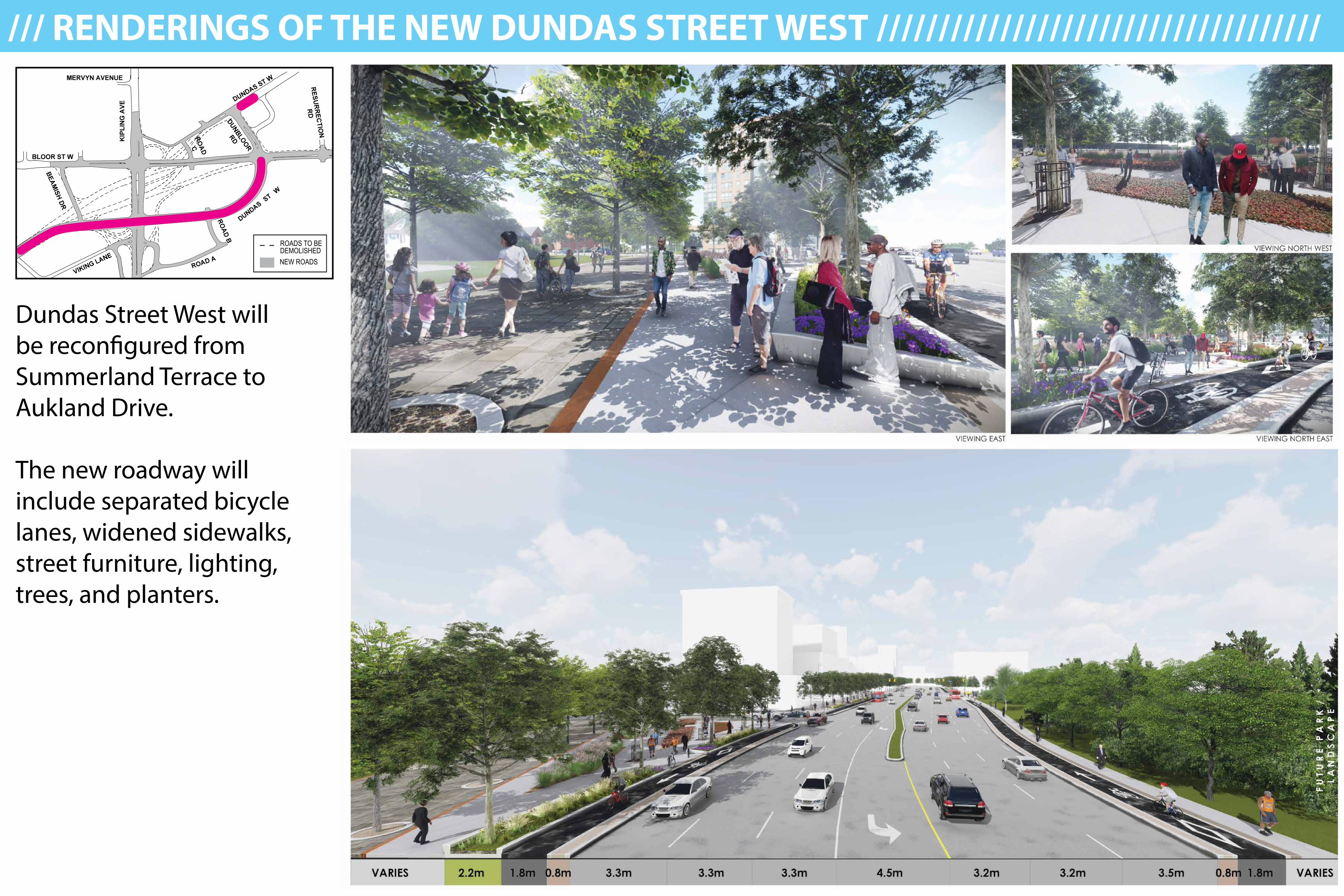
Dundas Street West will be reconfigured from Summerland Terrace to Aukland Drive.
The new roadway will include separated bicycle lanes, widened sidewalks, street furniture, lighting, trees, and planters.
/// RENDERINGS OF THE NEW DUNDAS STREET WEST ////////////////////////////////////
ROADS TO BE DEMOLISHEDNEW ROADS
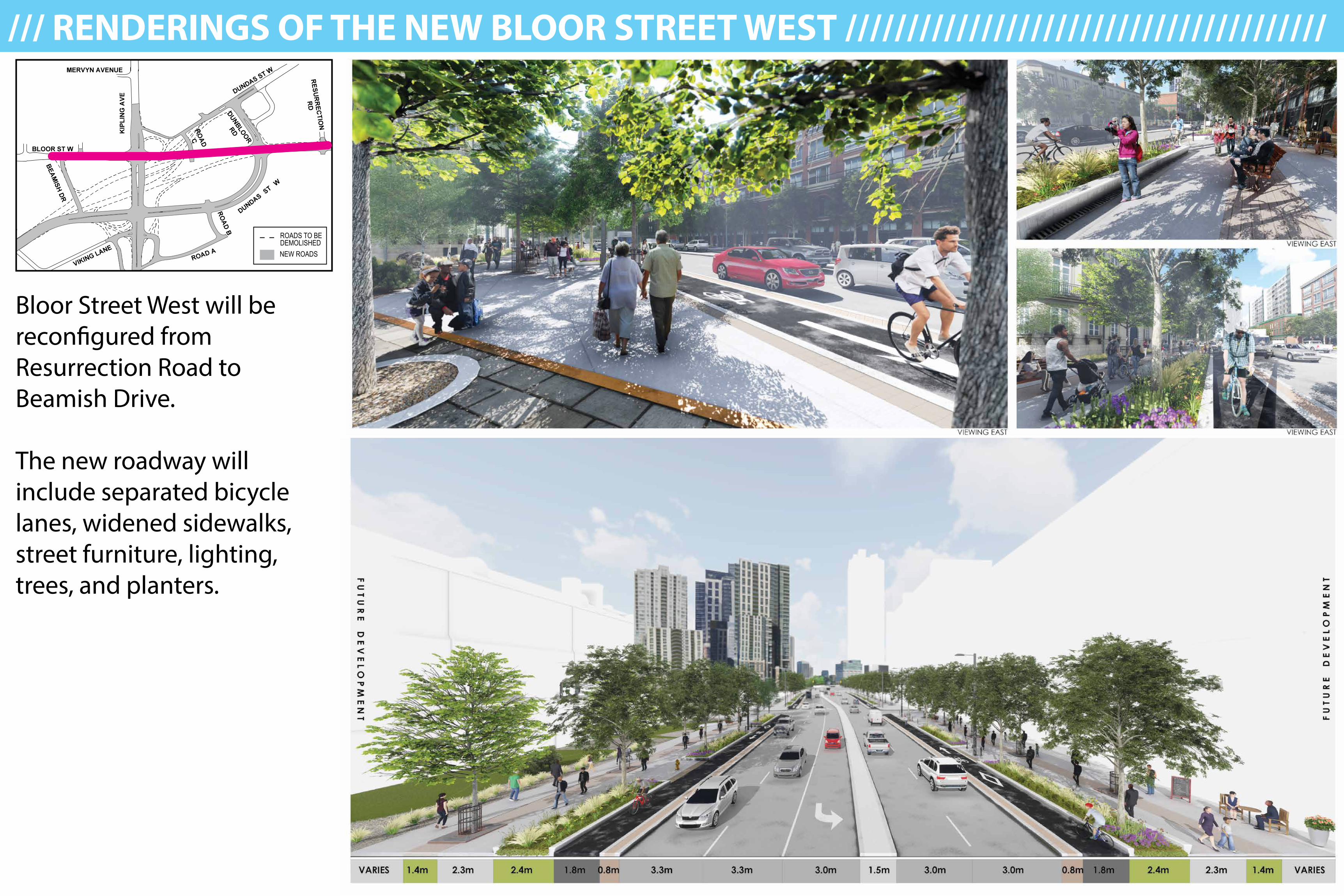
Bloor Street West will be reconfigured from Resurrection Road to Beamish Drive.
The new roadway will include separated bicycle lanes, widened sidewalks, street furniture, lighting, trees, and planters.
/// RENDERINGS OF THE NEW BLOOR STREET WEST ///////////////////////////////////////
ROADS TO BE DEMOLISHEDNEW ROADS
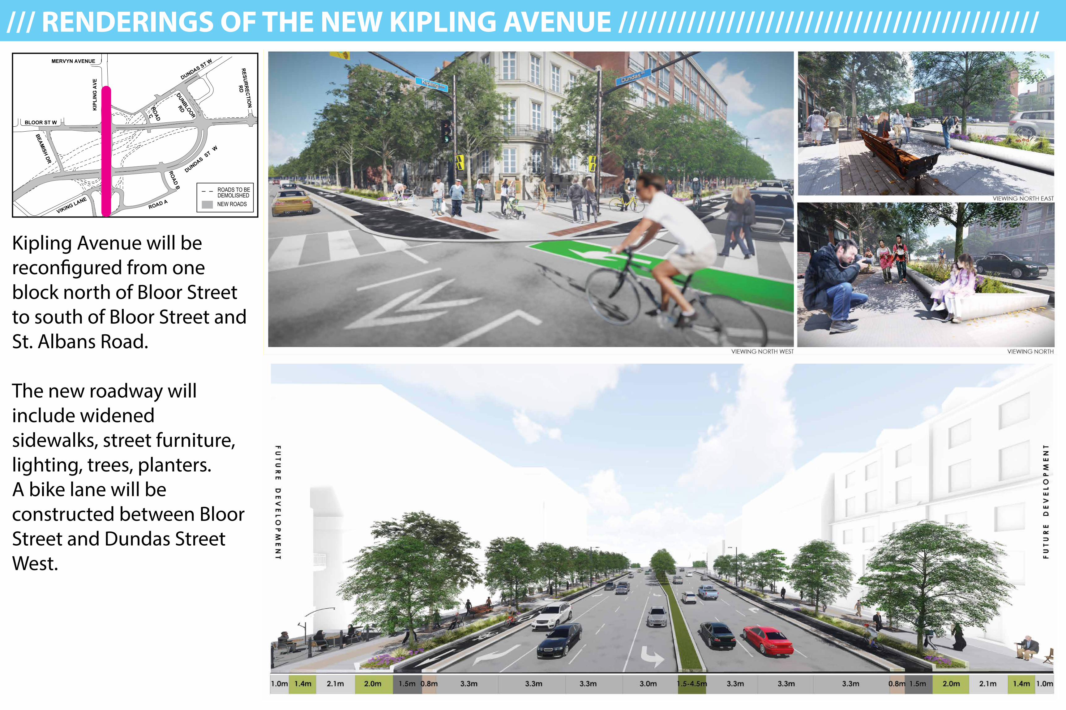
Kipling Avenue will be reconfigured from one block north of Bloor Street to south of Bloor Street and St. Albans Road.
The new roadway will include widened sidewalks, street furniture, lighting, trees, planters. A bike lane will be constructed between Bloor Street and Dundas Street West.
/// RENDERINGS OF THE NEW KIPLING AVENUE ///////////////////////////////////////////
ROADS TO BE DEMOLISHEDNEW ROADS
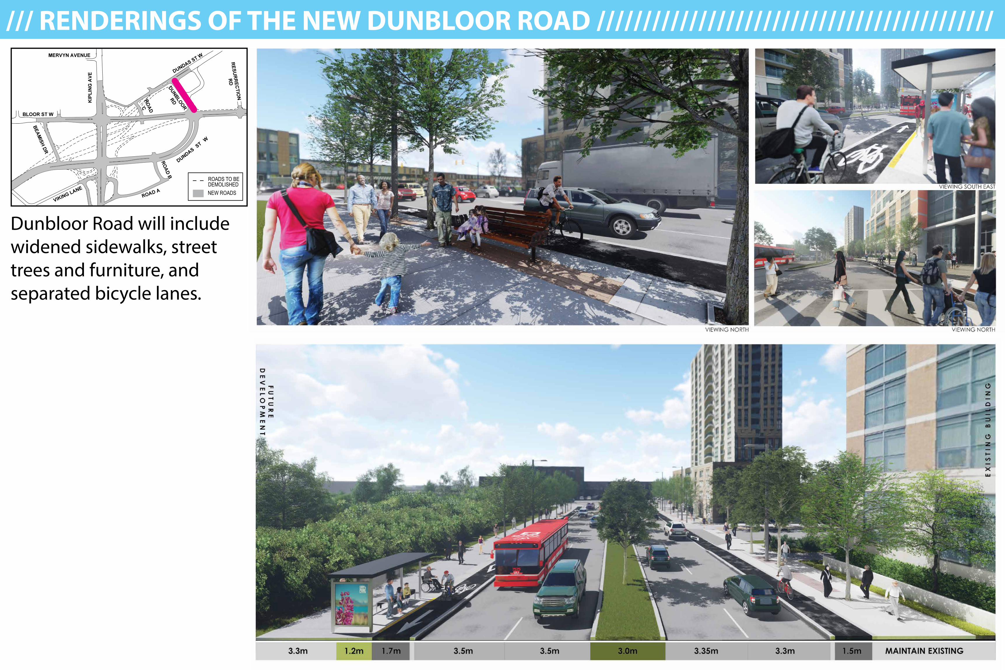
Dunbloor Road will include widened sidewalks, street trees and furniture, and separated bicycle lanes.
/// RENDERINGS OF THE NEW DUNBLOOR ROAD ///////////////////////////////////////////
ROADS TO BE DEMOLISHEDNEW ROADS
A NEW ETOBICOKE CENTRERECONSTRUCTING THE SIX POINTS INTERCHANGE
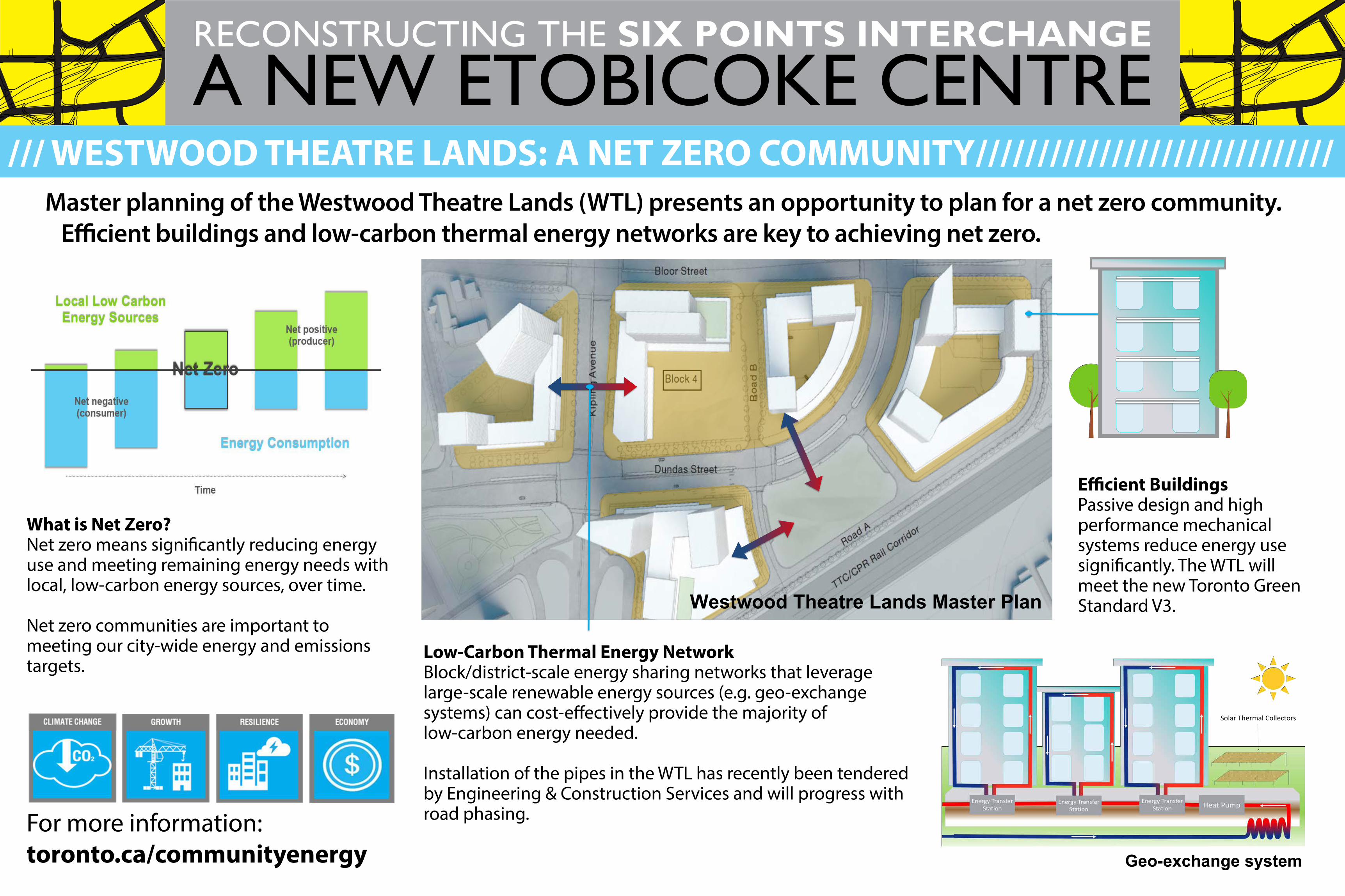
/// WESTWOOD THEATRE LANDS: A NET ZERO COMMUNITY/////////////////////////////
What is Net Zero?Net zero means significantly reducing energy use and meeting remaining energy needs with local, low-carbon energy sources, over time.
Net zero communities are important to meeting our city-wide energy and emissions targets.
Master planning of the Westwood Theatre Lands (WTL) presents an opportunity to plan for a net zero community. Efficient buildings and low-carbon thermal energy networks are key to achieving net zero.
Low-Carbon Thermal Energy NetworkBlock/district-scale energy sharing networks that leverage large-scale renewable energy sources (e.g. geo-exchange systems) can cost-effectively provide the majority of low-carbon energy needed.
Installation of the pipes in the WTL has recently been tendered by Engineering & Construction Services and will progress with road phasing.
Efficient BuildingsPassive design and high performance mechanical systems reduce energy use significantly. The WTL will meet the new Toronto Green Standard V3.
For more information:toronto.ca/communityenergy
WESTWOOD THEATRE LANDS: A NET ZERO COMMUNITY
Efficient Buildings
Low-Carbon Thermal Energy Network
Master planning of the Westwood Theatre Lands (WTL) presents an opportunity to plan for a net zerocommunity. Efficient buildings and low-carbon thermal energy networks are key to achieving net zero.
What is Net Zero?
Net zero means significantlyreducing energy use andmeeting remaining energyneeds with local, low-carbonenergy sources, over time.
Net zero communities areimportant to meeting our city-wide energy and emissionstargets.
Westwood Theatre Lands Master Plan
Geo-exchange system
Block/district-scale energy sharing networksthat leverage large-scale renewable energysources (e.g. geo-exchange systems) cancost-effectively provide the majority of low-carbon energy needed.
Installation of the pipes in the WTL has recentlybeen tendered by Engineering & ConstructionServices and will progress with road phasing.
Passive design and highperformance mechanicalsystems reduce energyuse significantly. The WTLwill meet the new TorontoGreen Standard V3.
For more information:toronto.ca/communityenergy
HEADER
WESTWOOD THEATRE LANDS: A NET ZERO COMMUNITY
Efficient Buildings
Low-Carbon Thermal Energy Network
Master planning of the Westwood Theatre Lands (WTL) presents an opportunity to plan for a net zerocommunity. Efficient buildings and low-carbon thermal energy networks are key to achieving net zero.
What is Net Zero?
Net zero means significantlyreducing energy use andmeeting remaining energyneeds with local, low-carbonenergy sources, over time.
Net zero communities areimportant to meeting our city-wide energy and emissionstargets.
Westwood Theatre Lands Master Plan
Geo-exchange system
Block/district-scale energy sharing networksthat leverage large-scale renewable energysources (e.g. geo-exchange systems) cancost-effectively provide the majority of low-carbon energy needed.
Installation of the pipes in the WTL has recentlybeen tendered by Engineering & ConstructionServices and will progress with road phasing.
Passive design and highperformance mechanicalsystems reduce energyuse significantly. The WTLwill meet the new TorontoGreen Standard V3.
For more information:toronto.ca/communityenergy
HEADER WESTWOOD THEATRE LANDS: A NET ZERO COMMUNITY
Efficient Buildings
Low-Carbon Thermal Energy Network
Master planning of the Westwood Theatre Lands (WTL) presents an opportunity to plan for a net zerocommunity. Efficient buildings and low-carbon thermal energy networks are key to achieving net zero.
What is Net Zero?
Net zero means significantlyreducing energy use andmeeting remaining energyneeds with local, low-carbonenergy sources, over time.
Net zero communities areimportant to meeting our city-wide energy and emissionstargets.
Westwood Theatre Lands Master Plan
Geo-exchange system
Block/district-scale energy sharing networksthat leverage large-scale renewable energysources (e.g. geo-exchange systems) cancost-effectively provide the majority of low-carbon energy needed.
Installation of the pipes in the WTL has recentlybeen tendered by Engineering & ConstructionServices and will progress with road phasing.
Passive design and highperformance mechanicalsystems reduce energyuse significantly. The WTLwill meet the new TorontoGreen Standard V3.
For more information:toronto.ca/communityenergy
HEADER
A NEW ETOBICOKE CENTRERECONSTRUCTING THE SIX POINTS INTERCHANGE
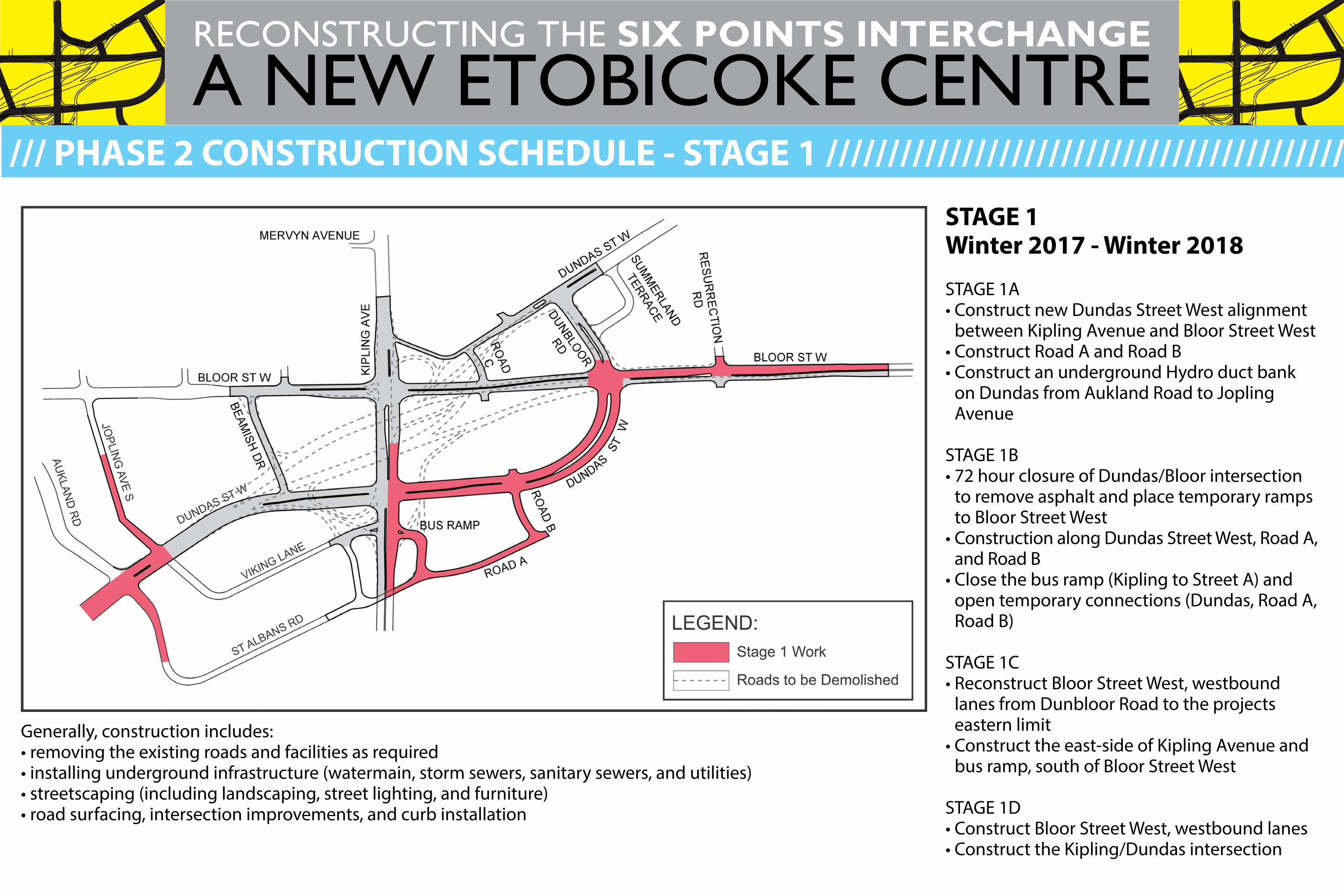
STAGE 1 Winter 2017 - Winter 2018
STAGE 1A• Construct new Dundas Street West alignment
between Kipling Avenue and Bloor Street West• Construct Road A and Road B• Construct an underground Hydro duct bank
on Dundas from Aukland Road to Jopling Avenue
STAGE 1B• 72 hour closure of Dundas/Bloor intersection
to remove asphalt and place temporary ramps to Bloor Street West
• Construction along Dundas Street West, Road A, and Road B
• Close the bus ramp (Kipling to Street A) and open temporary connections (Dundas, Road A, Road B)
STAGE 1C• Reconstruct Bloor Street West, westbound
lanes from Dunbloor Road to the projects eastern limit
• Construct the east-side of Kipling Avenue and bus ramp, south of Bloor Street West
STAGE 1D• Construct Bloor Street West, westbound lanes• Construct the Kipling/Dundas intersection
/// PHASE 2 CONSTRUCTION SCHEDULE - STAGE 1 //////////////////////////////////////////
Generally, construction includes:• removing the existing roads and facilities as required• installing underground infrastructure (watermain, storm sewers, sanitary sewers, and utilities)• streetscaping (including landscaping, street lighting, and furniture)• road surfacing, intersection improvements, and curb installation
A NEW ETOBICOKE CENTRERECONSTRUCTING THE SIX POINTS INTERCHANGE
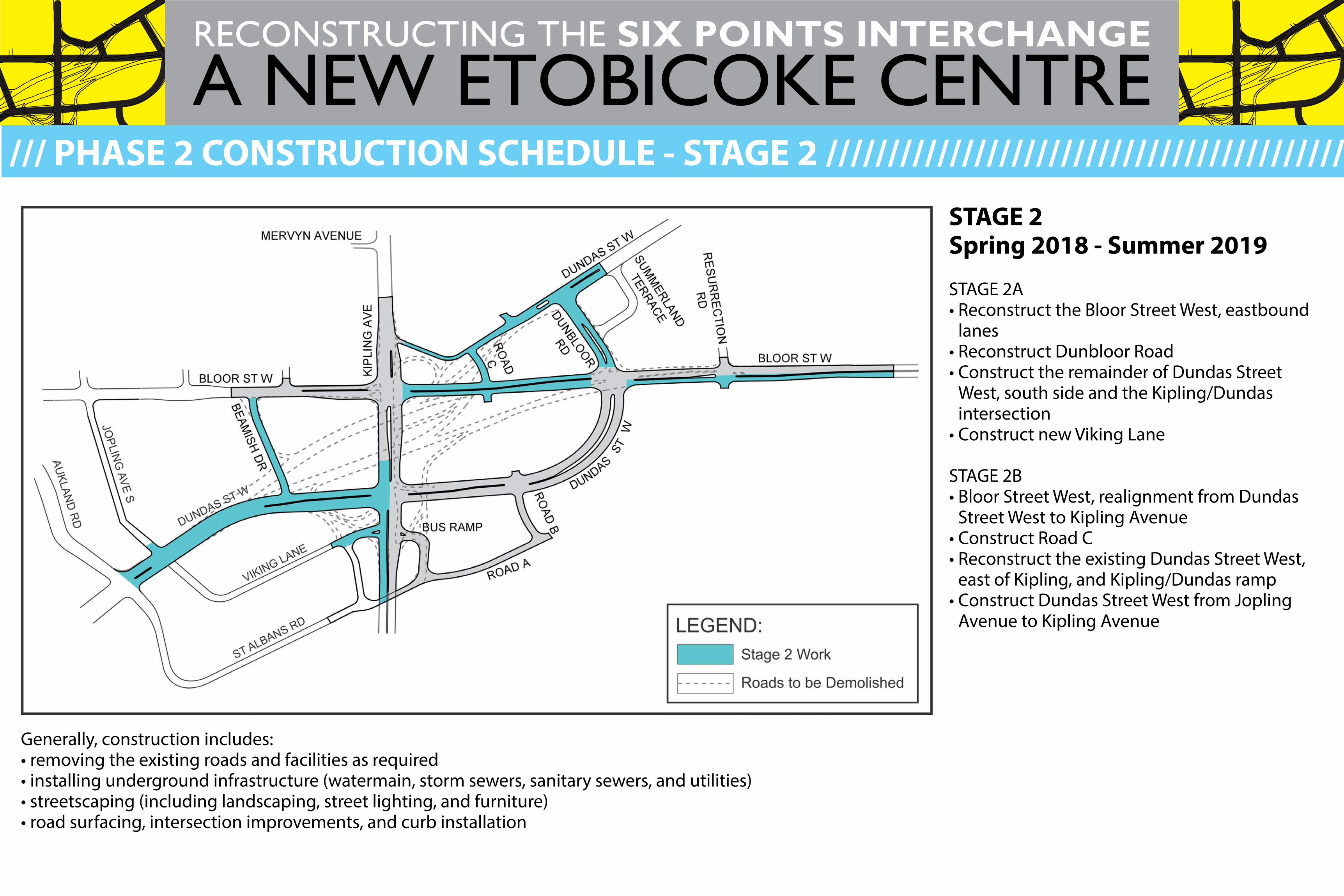
STAGE 2Spring 2018 - Summer 2019
STAGE 2A• Reconstruct the Bloor Street West, eastbound
lanes• Reconstruct Dunbloor Road• Construct the remainder of Dundas Street
West, south side and the Kipling/Dundas intersection
• Construct new Viking Lane
STAGE 2B• Bloor Street West, realignment from Dundas
Street West to Kipling Avenue• Construct Road C• Reconstruct the existing Dundas Street West,
east of Kipling, and Kipling/Dundas ramp• Construct Dundas Street West from Jopling
Avenue to Kipling Avenue
/// PHASE 2 CONSTRUCTION SCHEDULE - STAGE 2 //////////////////////////////////////////
Generally, construction includes:• removing the existing roads and facilities as required• installing underground infrastructure (watermain, storm sewers, sanitary sewers, and utilities)• streetscaping (including landscaping, street lighting, and furniture)• road surfacing, intersection improvements, and curb installation
A NEW ETOBICOKE CENTRERECONSTRUCTING THE SIX POINTS INTERCHANGE
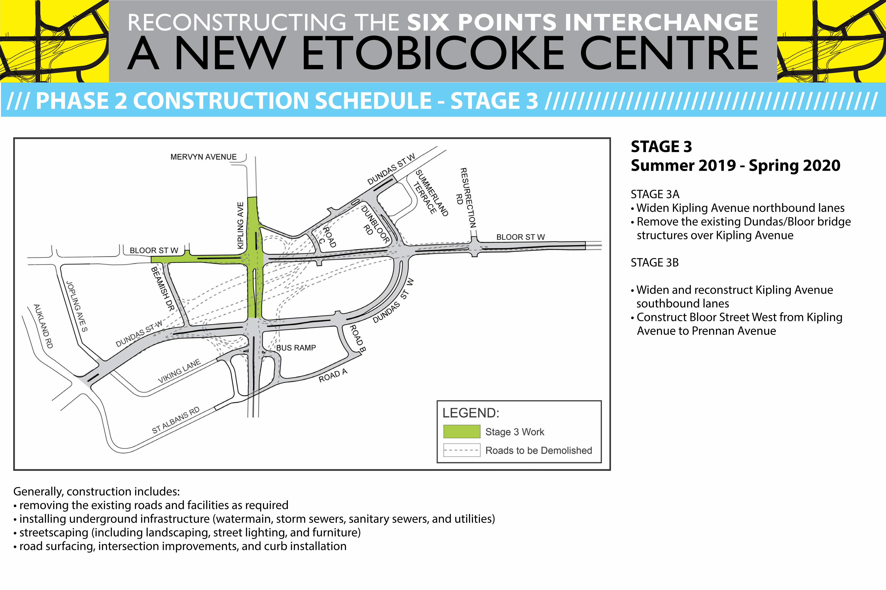
/// PHASE 2 CONSTRUCTION SCHEDULE - STAGE 3 /////////////////////////////////////////
STAGE 3Summer 2019 - Spring 2020
STAGE 3A• Widen Kipling Avenue northbound lanes• Remove the existing Dundas/Bloor bridge
structures over Kipling Avenue
STAGE 3B
• Widen and reconstruct Kipling Avenue southbound lanes
• Construct Bloor Street West from Kipling Avenue to Prennan Avenue
Generally, construction includes:• removing the existing roads and facilities as required• installing underground infrastructure (watermain, storm sewers, sanitary sewers, and utilities)• streetscaping (including landscaping, street lighting, and furniture)• road surfacing, intersection improvements, and curb installation
A NEW ETOBICOKE CENTRERECONSTRUCTING THE SIX POINTS INTERCHANGE
ROAD AND SIDEWALK ACCESS In order to complete the work in a safe manner, there will be road and sidewalk restrictions within the construction work zone. Access for emergency vehicles will be maintained at all times.
DRIVEWAY ACCESSThe contractor will notify residents of any temporary driveway access restrictions. If your property has two entrances, one entrance will be kept open at all times.
TRAFFIC MANAGEMENTEfforts have been made to manage traffic in the area for the safety of workers, road users and residents. Road users should expect delays and increased traffic on nearby main and side streets.
PARKING Parking in the active work zone is not permitted due to space require-ments for construction equipment and materials. If your parked vehicle
affects the construction work, it will be re-located with no charge to the owner. If your vehicle is moved, please contact park-ing control for its location at 416-808-2222.
GARBAGE & RECYCLINGPlease follow your normal routine. If required, the contractor will move bins to an appropriate location and return them. Please ensure that you label your bins with your address.
RESTORATIONThe construction work area will be restored with sod and/or asphalt where required in future stages of the work. Updates will be provided.
TRANSIT SERVICEThis project will affect travel times of ALL TTC and MiWay Routes to and from Kipling Subway Station that travel along Dundas Street West.
Visit ttc.ca or miway.ca for accurate schedule information.
You may experience dust, noise and other inconveniences. The City will make efforts to reduce the impacts. We appreciate your patience.
Work will take place from 7:00 am to 7:00 pm., Monday to Friday, with work after hours and on weekends as required.
Notification about construction impacts will be sent to affected property owners, residents, and businesses, in advance of any construction disruptions via direct mail.
Questions and comments can be directed to:Meghan Bratt, Field Ambassador416-338-7755 | [email protected]
/// WHAT TO EXPECT DURING CONSTRUCTION //////////////////////////////////////////////

A NEW ETOBICOKE CENTRERECONSTRUCTING THE SIX POINTS INTERCHANGE
Building a great city takes time. During construction we will keep you informed about
what’s happening, what’s next, and progress made.www.toronto.ca/etobicokecentre
CONTACT YOUR FIELD AMBASSADOR
Your Field Ambassador is your main point of contact for questions and concerns about reconstruction of the Six Points Interchange.
Meghan Bratt, Field [email protected]
416-338-7755
SIGN UP FOR EMAIL UPDATES
Stay up to date on construction milestones and opportunities to get involved by signing up to receive updates on the project website.
Your contact information will be kept private, and will only be used to share information about the Six Points Interchange Reconfiguration.
NOTIFICATION + NEWSLETTERS
Notification about construction impacts will be sent to property owners 2 weeks in advance of construction via Canada Post delivery.
Newsletters will be sent at key project milestones to share information on construction progress and what’s next.
@
/// STAY INFORMED ///////////////////////////////////////////////////////////////////////////////
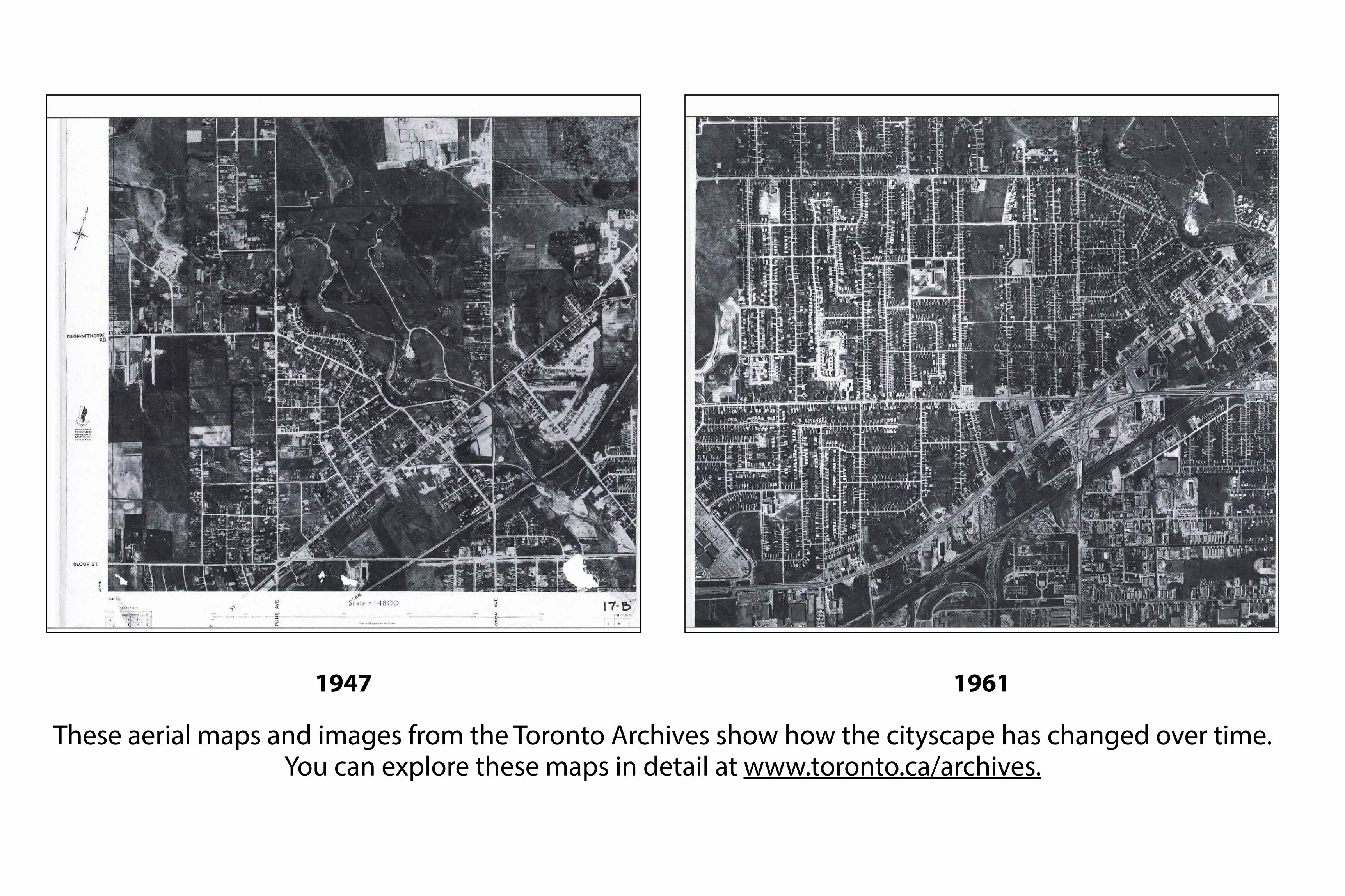
1947 1961
These aerial maps and images from the Toronto Archives show how the cityscape has changed over time. You can explore these maps in detail at www.toronto.ca/archives.
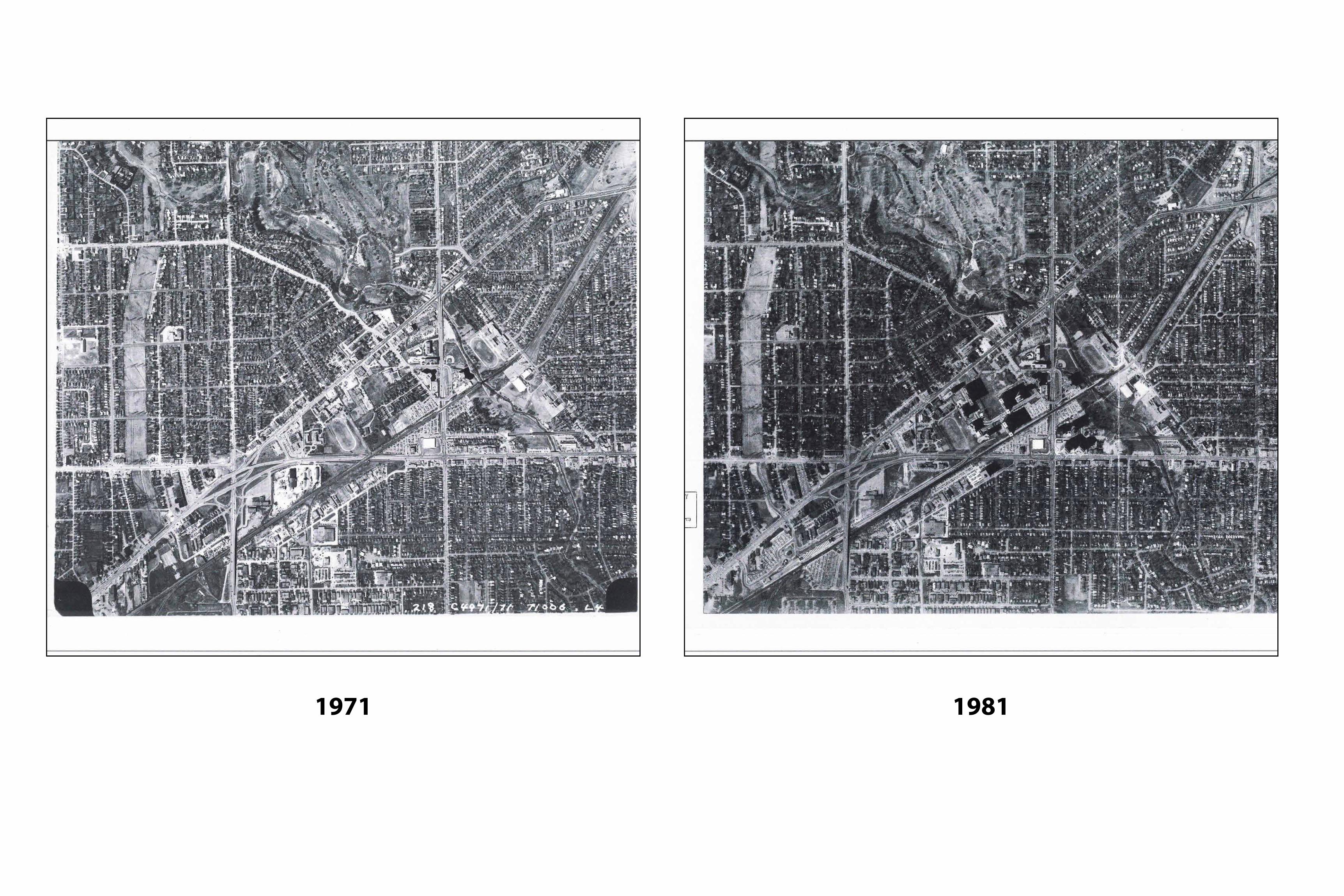
1971 1981
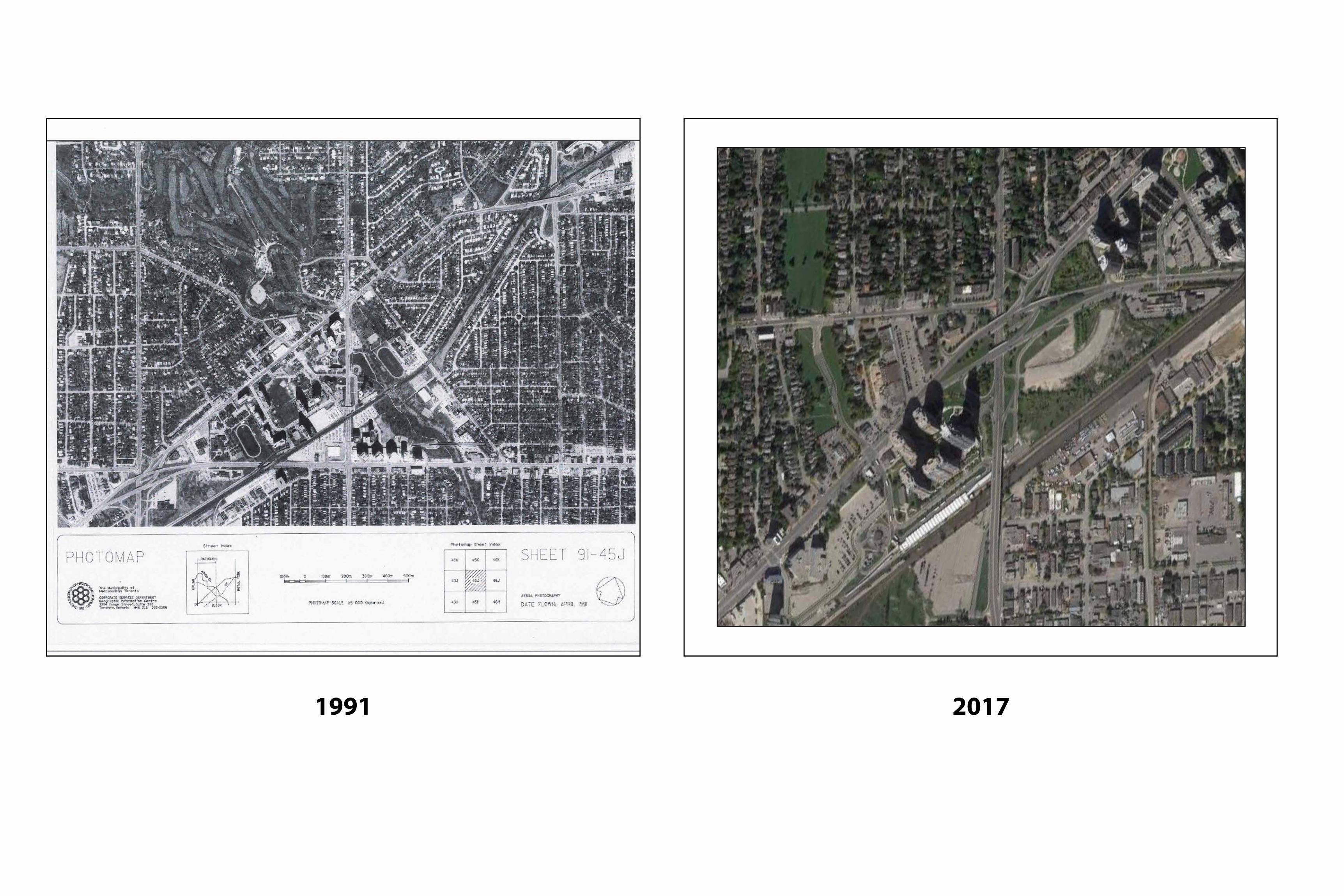
1991 2017
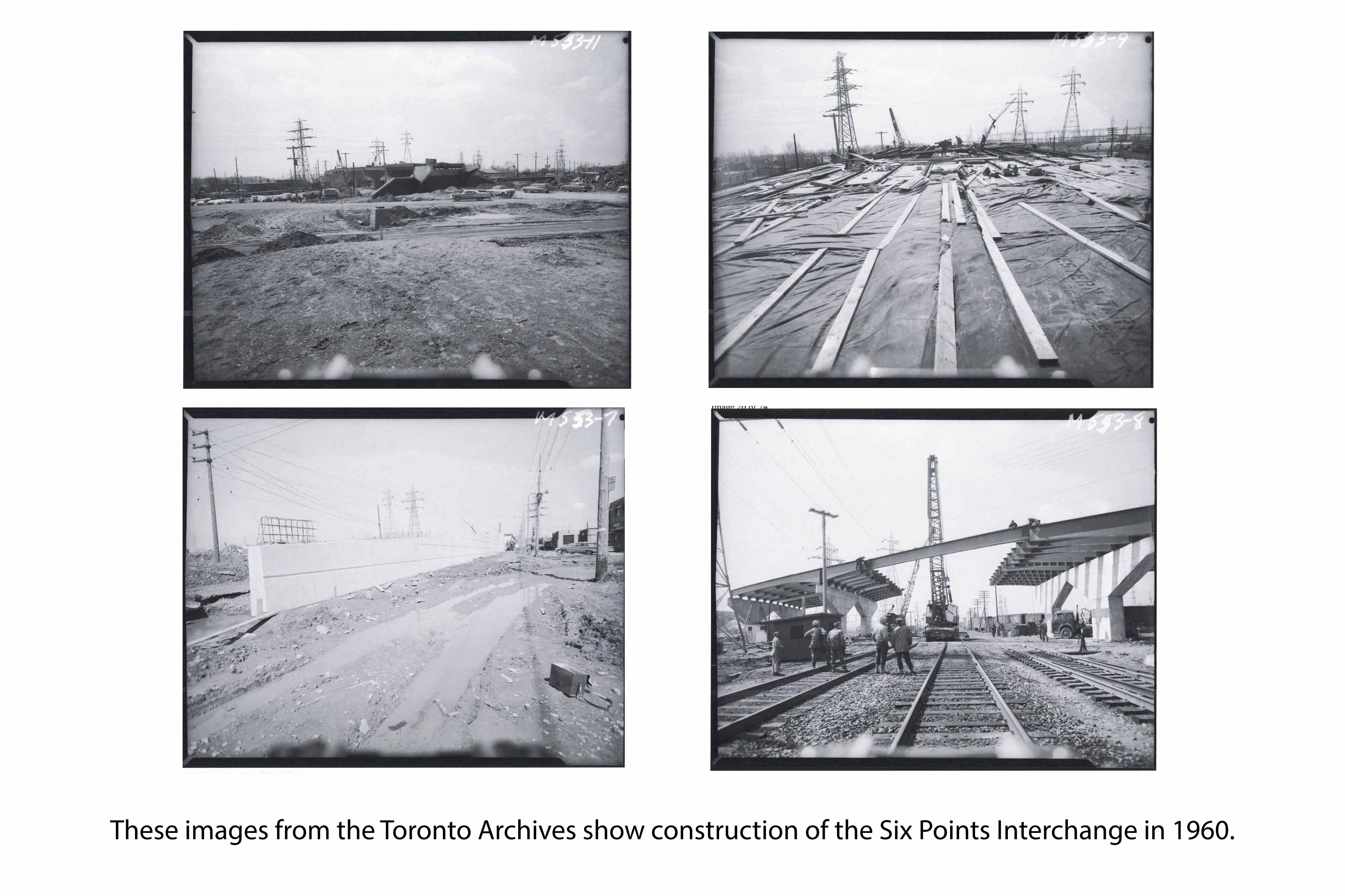
These images from the Toronto Archives show construction of the Six Points Interchange in 1960.
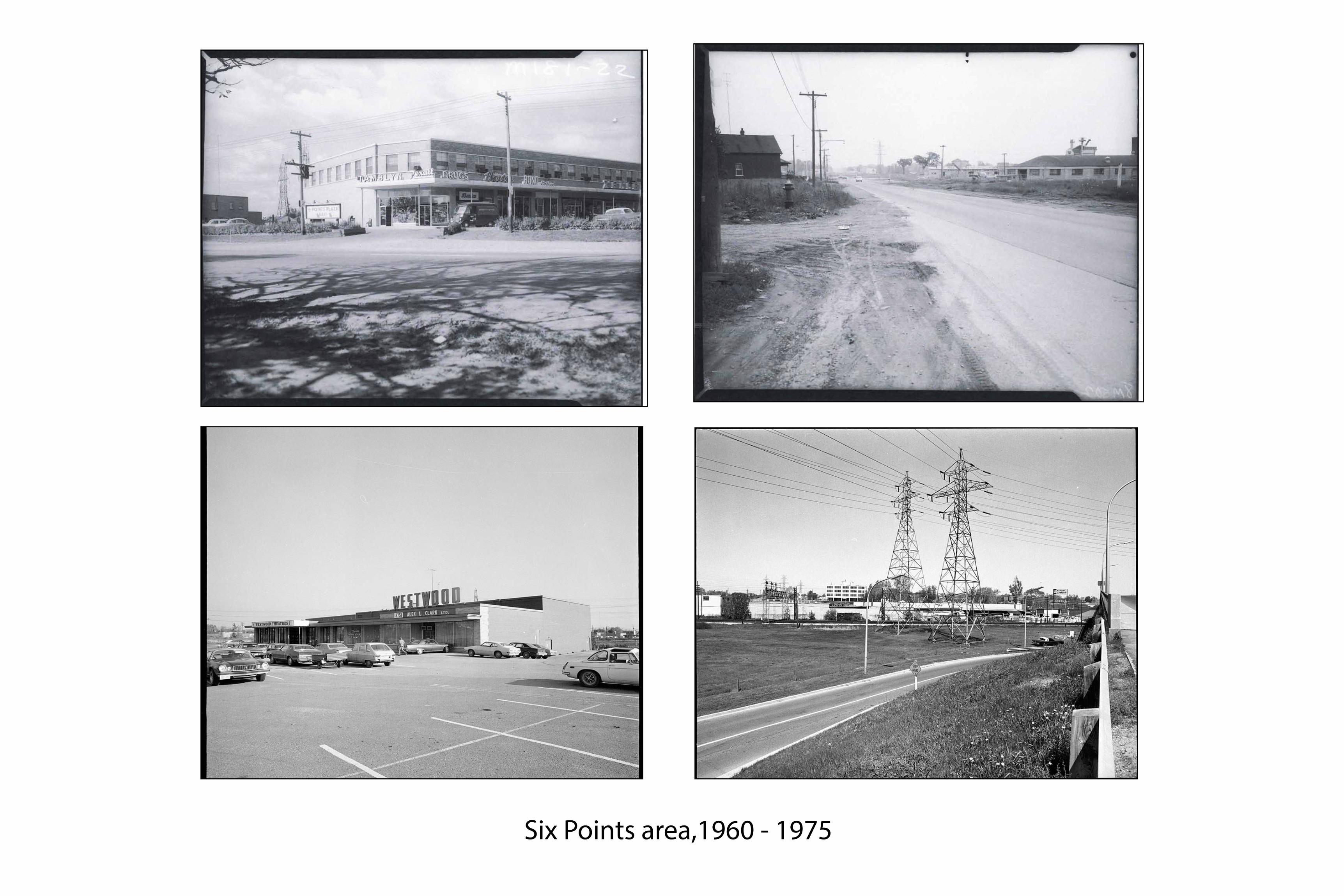
Six Points area,1960 - 1975
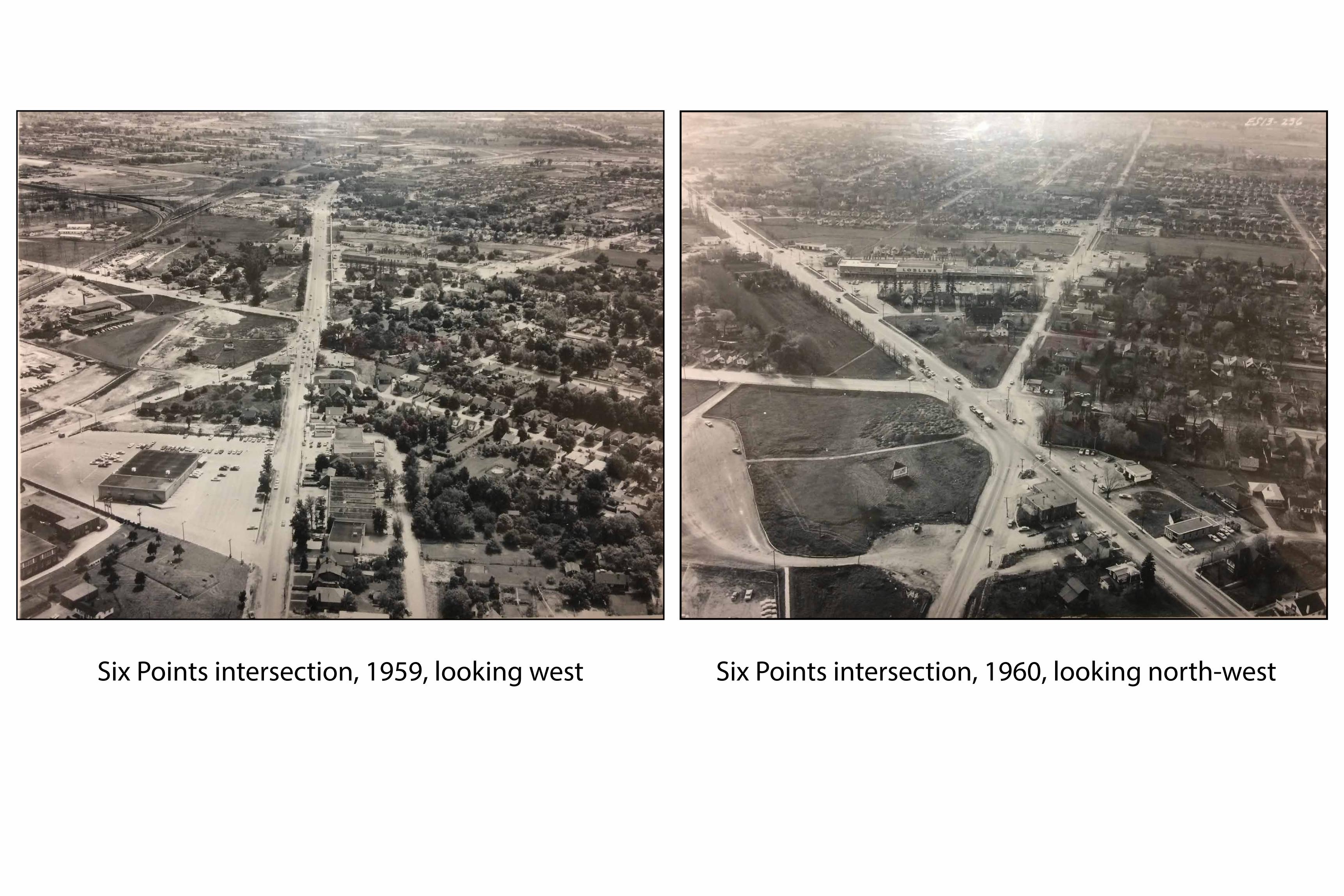
Six Points intersection, 1959, looking west Six Points intersection, 1960, looking north-west
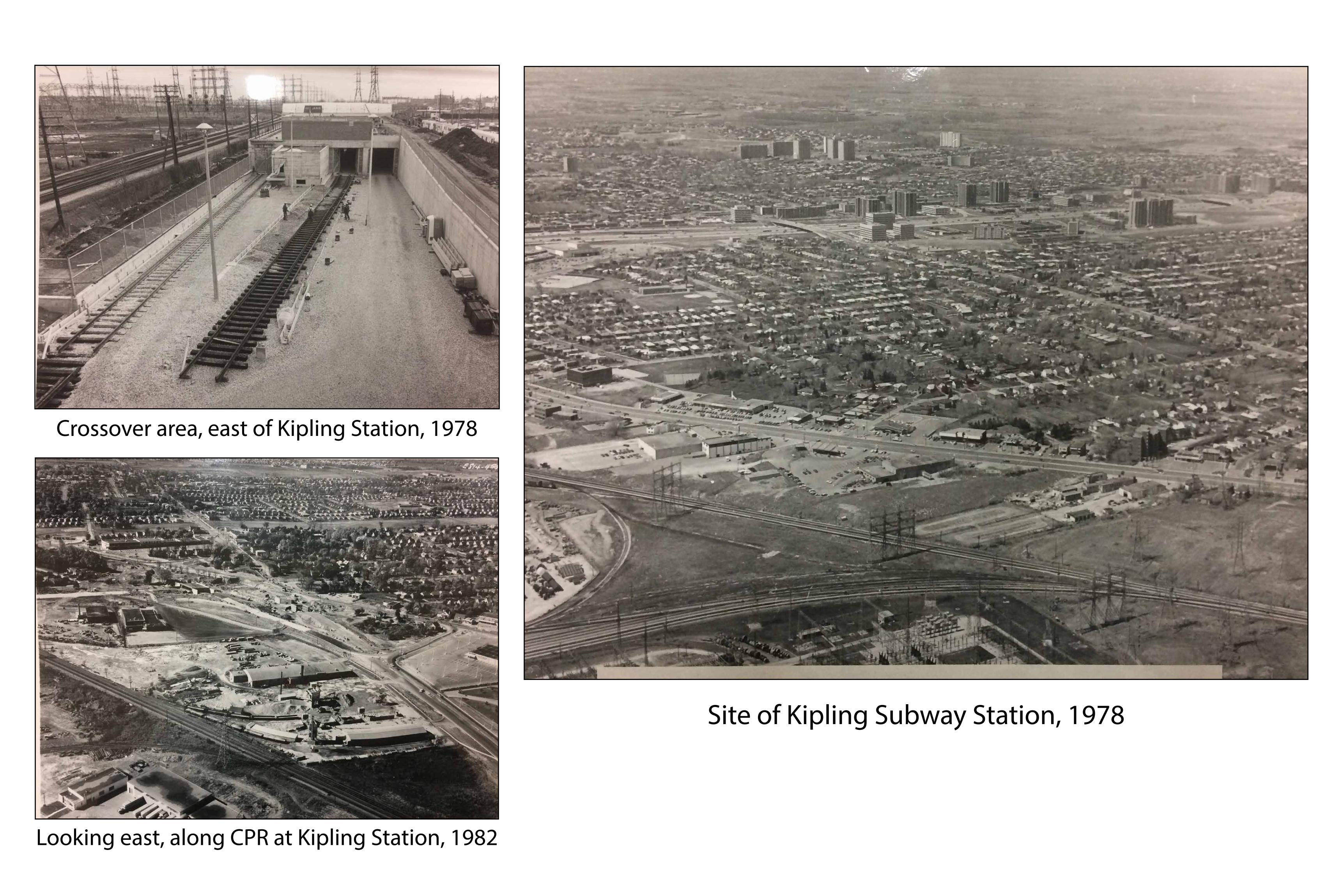
Site of Kipling Subway Station, 1978
Crossover area, east of Kipling Station, 1978
Looking east, along CPR at Kipling Station, 1982
SIX POINTS INTERCHANGE RECONFIGURATION
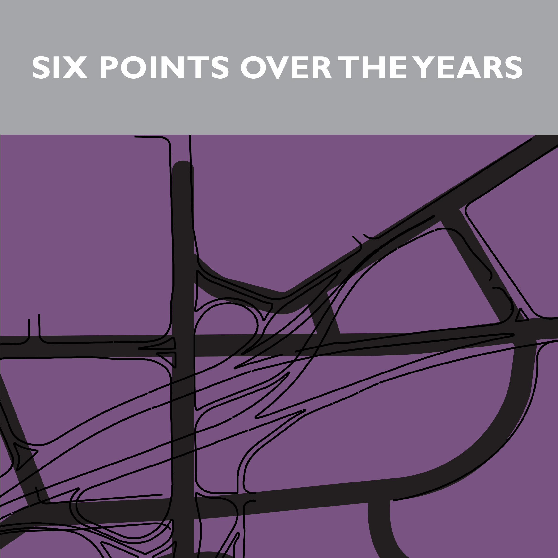
SIX POINTS OVER THE YEARS
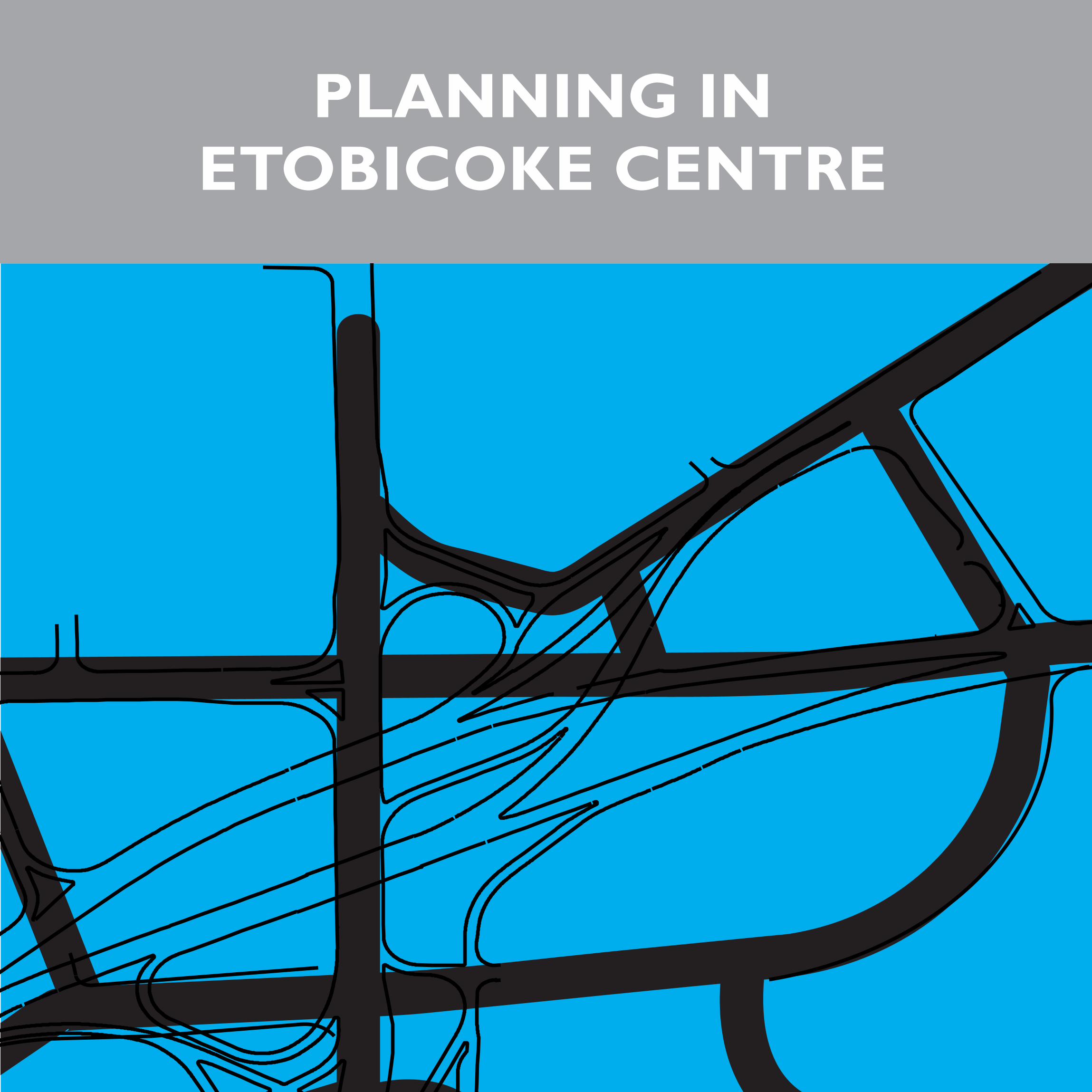
PLANNING IN ETOBICOKE CENTRE
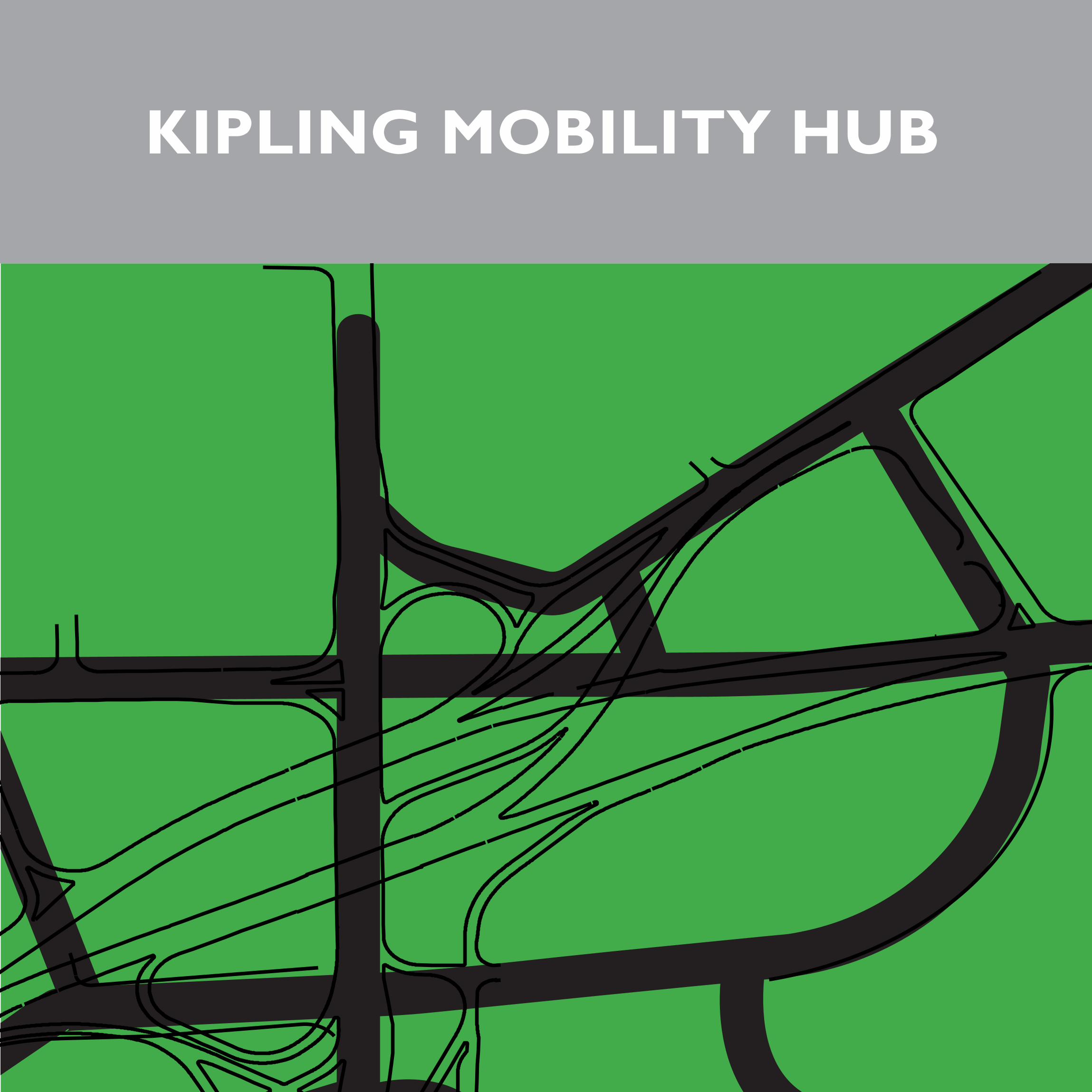
KIPLING MOBILITY HUB
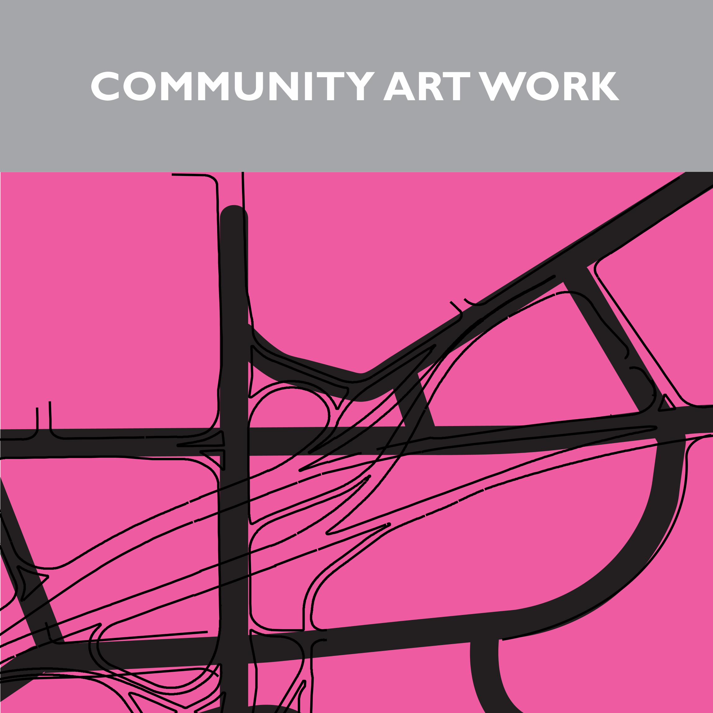
COMMUNITY ART WORK