Embed Size (px)
Citation preview

http://www.iaeme.com/IJCIET/index.asp 910 [email protected]
International Journal of Civil Engineering and Technology (IJCIET)
Volume 10, Issue 05, May 2019, pp. 910-929, Article ID: IJCIET_10_05_092
Available online at http://www.iaeme.com/ijciet/issues.asp?JType=IJCIET&VType=10&IType=5
ISSN Print: 0976-6308 and ISSN Online: 0976-6316
© IAEME Publication
RECONSIDERATION OF THE LOWER
CAMBRIAN EXTENSION IN THE ANTI-ATLAS
BELT, MOROCCO
* Mohamed Yazidi, Khadija Kaid Rassou and Bouchra Razoki
Natural Resources Geosciences Laboratory (NRGL), Department of Geology, Faculty of
Sciences, Ibn Tofail University. Kenitra, Morocco
Geoscience and Geodidactics Team (GGT), Department of Life and Earth Sciences, Regional
Centre for Education and Training Professions (CRMEF Marrakech). Morocco
Fouad Benziane and Abdelaziz Yazidi
Laboratory of Geology; The National School of Mines of Rabat (ENIM), Rabat, Morocco
Saïd Chakiri, Zohra Bejjaji and Mohamed Allouza
Natural Resources Geosciences Laboratory (NRGL), Department of Geology, Faculty of
Sciences, Ibn Tofail University. Kenitra, Morocco
Hassan El Hadi
Laboratory of Applied Geology, Geomatics and Environment, Faculty of Sciences Ben
M‟Sik, University Hassan II, Casablanca, Morocco
Said Ettazarini
Laboratory of Remote sensing and geomatics. Multidisciplinary faculty Taza. University Sidi
Mohamed Ben Abdellah. Morocco
*Corresponding Author
ABSTRACT
The Anti-Atlas belt, which is located in the western part of the West African
Craton, is the result of Eburnean, Pan African and Variscan successive orogenies,
during the Paleoproterozoic, the Neoproterozoic and the Paleozoic. The subsequent
crustal accretions enlarged the craton, forming a series of belts in form of crowns.
In the Anti-Atlas, the Cambrian can be defined by paleontological or radiometric
dating. In the first case, the definition of its chronological lower limit can fluctuate
according to new results. In the second case, the intercalated volcanic levels are
younger and younger. In this study, we have grouped Adoudounian and Taliwinian in
a large lower Cambrian and not in any terminal Neoproterozoic.
The volcano-sedimentary and sedimentary formations of the Adoudounian and the
Taliwinian cover the Precambrian formations of the different domes.
Reconsideration of the Lower Cambrian Extension in the Anti-Atlas Belt, Morocco
http://www.iaeme.com/IJCIET/index.asp 911 [email protected]
Key words: Anti-Atlas, West African Craton, orogenies, lower Cambrian, Adoudounian and
Taliwinian.
Cite this Article: Mohamed Yazidi, Khadija Kaid Rassou, Bouchra Razoki, Fouad
Benziane, Abdelaziz Yazidi, Saïd Chakiri, Zohra Bejjaji, Mohamed Allouza, Hassan
El Hadi, Said Ettazarini, Reconsideration of the Lower Cambrian Extension in the
Anti-Atlas Belt, Morocco, International Journal of Civil Engineering and Technology
10(5), 2019, pp. 910-929.
http://www.iaeme.com/IJCIET/issues.asp?JType=IJCIET&VType=10&IType=5
1. INTRODUCTION
The interest of stratigraphic series of the Moroccan Anti-Atlas is very important for several
reasons. The most important is that outcrops are continuous and well exposed. Indeed, the
transition from the Upper Neoproterozoic to the Cambrian is still the subject of much debate
(Choubert and Faure-Muret 1962; Landing et al., 1998; Benziane, 2007; Alvaro et al., 2008,
Alvaro et al., 2014; Geyer and Landing, 2016; Yazidi et al 2016; Pouclet et al., 2018). Indeed,
the importance of stratigraphic series is essential for the understanding of the Neoproterozoic
- Lower Cambrian boundary. Many previous works have focused on the description and
characterization of the stratigraphic boundary separating Upper Ediacaran and Lower
Cambrian in the Anti-Atlas (Geyer and Landing, 1995, 2004 and 2006, Maloof et al., 2005
and 2010; Alvaro et al., 2014; Landing et al., 2018).
The present work aims at a revised description of the Lower Cambrian based on
geological mapping research data carried out in recent years in the Anti-Atlas (Yazidi et al.,
2002, 2008 and 2016; Benziane et al., 2002, 2007, 2008 and 2016; Harrison and al., 2008,
Walsh et al., 2002 and 2008), supplemented by data available in the literature such as those of
: Ducrot and Lancelot, 1977; Boudda et al., 1979; Bertrand-Sarfati, 1981; Benziane et al.,
1983, Destombes et al., 1985; Buggisch et al., 1988; Geyer; 1989, 1990a, b and 1995;
Soulaimani et al., 2003 and 2013; Gasquet et al., 2005; Soulaimani et al., 2014; Alvaro et al.,
2008 and Alvaro et al., 2014. The available dating data in Benziane et al., (2016) is also used
to discuss the redefinition of the "Lower Cambrian" subperiod and its extension.
2. GEOGRAPHIC CONTEXT
Numerous studies on the Anti-Atlas and more particularly those of Choubert (1963) and
Choubert and Faure-Muret (1970 and 1983) allow subdividing this region into three structural
domains (Choubert and al., 1980) (Figures 1 and 2):
The western part, which contains the Siroua, Tagragra of Tata and Ifni inliers;
The central part which includes the Bou Azzer, Zenaga and Siroua inliers;
The eastern part, which contains the Saghro and Ougnat inliers.
Meanwhile, according to Leblanc (1975), the Anti-Atlas is subdivided into two major
structural domains separated by the Major Fault of the Anti-Atlas (Figures 1 and 2):
An old (Eburnean) south-western domain;
A recent (pan-African) north-eastern domain.
The studies carried out in each field by numerous authors allow establishing chrono-
lithostratigraphic successions that may be different from one author to another. Therefore, the
correlation of formations by considering two or three domains in the Anti-Atlas becomes very
difficult.
Mohamed Yazidi, Khadija Kaid Rassou, Bouchra Razoki, Fouad Benziane, Abdelaziz Yazidi,
Saïd Chakiri, Zohra Bejjaji, Mohamed Allouza, Hassan El Hadi, Said Ettazarini
http://www.iaeme.com/IJCIET/index.asp 912 [email protected]
This study will present the Lower Cambrian series on the basis of subdivisions derived
from previous geological mapping work covering many areas of the Anti-Atlas (Benziane et
al., 2002, 2007, 2008 and 2016; Walsh et al., 2008 and Yazidi et al., 2002, 2008 and 2016).
Figure 1 General map of West African Craton. According to Dallmeyer and Lécorché (1991) cited in
Piqué (2001).
3. GEOLOGY OVERVIEW OF THE ANTI-ATLAS
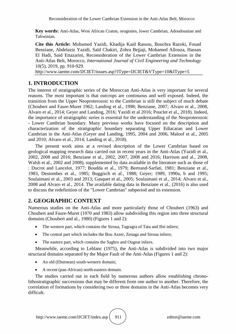
The chain of the Anti-Atlas is located on the northern edge of West African Craton (figure 1).
Its general shape is a large anticline where the inliers constitute the heart. The Anti-Atlas
range covers an area of approximately 750 km long and 250 km wide, oriented SW-NE, from
the Atlantic Ocean in the west to Algeria in the east. The Anti-Atlas is limited to the north by
the major South Atlas fault (figure 2).
Figure 2 Schematic geological map of the Moroccan Anti-Atlas.

Reconsideration of the Lower Cambrian Extension in the Anti-Atlas Belt, Morocco
http://www.iaeme.com/IJCIET/index.asp 913 [email protected]
The Precambrian consists of Proterozoic rocks that crop out in inliers after erosion under a
Paleozoic cover. Paleozoic formations surround the Precambrian formations and correspond
to platform deposits in a shallow sea environment, in regular subsidence (Robert-Charrue,
2006). Their deformation during the Variscan Orogeny influenced the current shape of the
Anti-Atlas. The Paleozoic series are more than 10,000 m thick in the western Anti-Atlas, and
do not exceed 6,000 m in the eastern Anti-Atlas. They begin with platform carbonate deposits
of the Lower Cambrian (Boudda et al., 1979, Geyer and Landing, 1995).
The Paleozoic of the Anti-Atlas domain begins with lower Cambrian series lying with
concordance on the upper Ediacaran alkaline basalts and only separates them from an erosion
unconformity. Early Paleozoic cover rocks deposited in a shallow marine platform
environment.
The Cambrian formations crop out largely in the field. In this study, we will adopt on the
one hand the international stratigraphic scale for the terms and the chronological limits and on
the other hand the subdivision of the Anti-Atlas into three practical domains for the
understanding of the pan-African orogenesis.
In the Anti-Atlas, one distinguishes the outcroppings attributed to the Cambrian,
according to their palaeontological content, and those dated by the radiometric methods.
The "paleontological" Lower Cambrian begins with a new transgression with deposits of a
limestone and clay series where trilobites and Archaeocyata will proliferate;
The "radiometric" Cambrian where the interbedded volcanic levels in the sediments of the
Adoudou Formation gave radiometric ages between 532 ± 12 Ma (Pouclet et al., 2008) and
517 ± 1.5 Ma (Landing et al., 1998). The Cambrian cycle began at an age of less than 541.0 ±
1.0 Ma (Cohen et al., 2018).
4. LITHOSTRATIGRAPHIC EVOLUTION OF THE CAMBRIAN
BELOW THE ANTI-ATLAS
The geological history of the Anti-Atlas inliers began in the Paleoproterozoic and continued
during the Middle Neoproterozoic (Cryogenian or NP2) and Upper Neoproterozoic
(Ediacarian or NP3) and Paleozoic to the present day (Yazidi and al., 2016). Also, no tectonic
unconformity separates the lower Cambrian from the upper Ediacaran (Benziane et al., 2016).
Indeed, the main feature of the Anti-Atlas is the considerable development of lower
Cambrian limestones that can reach 5000 meters thick in the northwest of the Western Anti-
Atlas. These limestones crop out in the western Anti-Atlas and in the southern part of the
central Atlas (Choubert and Marçais, 1952). Lower Cambrian limestones of the Eastern Anti-
Atlas are less thick (figure 3).
These observations suggest that after the volcanic and plutonic phase of the Upper
Ediacaran (NP3s), the northern edge of the West African Craton performed as a passive
margin. A marine transgression from the NW in the Western Anti-Atlas deposited platform
formations, carbonates and silts.

Mohamed Yazidi, Khadija Kaid Rassou, Bouchra Razoki, Fouad Benziane, Abdelaziz Yazidi,
Saïd Chakiri, Zohra Bejjaji, Mohamed Allouza, Hassan El Hadi, Said Ettazarini
http://www.iaeme.com/IJCIET/index.asp 914 [email protected]
Figure 3 Lower Cambrian deposits in the Anti-Atlas. According to Choubert, in Benziane and al.
(1983) and Cornea, 1989.
The Paleozoic volcano-sedimentary cover is conformable with the magmatic formations
of the Upper Ediacarian.
The first volcano-sedimentary and sedimentary formations of the Lower Cambrian are of
Adoudounian age (Choubert, 1952 classification). They cover the Precambrian formations of
the Anti-Atlas inliers. The absence of paleontological witnesses in the Adoudou Formation
allows us to attribute it to an early Cambrian or Infracambrian Cambrian (Yazidi et al., 2007).
We will start the "palaeontological" Cambrian with the Taliwine Formation and the
Cambrian "radiometric" with the Adoudounian as confirm the radiometric ages obtained in
the Bou Azzer inlier (Benziane et al., 2007) on the interbedded volcanic rocks (Figure 4).
Also, according to our different recent studies (Yazidi et al., 2016, Benziane et al., 2016) on
the Anti-Atlas area, we have gathered the formations from the Adoudounian to the ultimate
sandstone series (“Grès Terminaux”) in lower Cambrian (sl).
Figure 4 Northern border of the Bou Azzer inlier: the dark horizons correspond to trachytes in
interbedded flows in the adoudounian dolomites.

Reconsideration of the Lower Cambrian Extension in the Anti-Atlas Belt, Morocco
http://www.iaeme.com/IJCIET/index.asp 915 [email protected]
The Paleozoic sedimentary cycle begins in the Lower Cambrian (s.l.). The latter includes
the Taroudant Group (Adoudou Formation and Taliwine Formation) followed by the Tata or
Lower Cambrian Group, in the strict sense of the term (s.s.). Thus, the formations of the
lower Cambrian (s.l.) ranging from the Adoudounian to the paleontological Cambrian,
constitute the cover of the Precambrian formations of the different inliers of the Anti-Atlas.
4.1. Taroudant Group (Figure 5)
At the end of the magmatic cycle (ultimate Proterozoic), a subsidence of the pan-African
margin leads to widespread floods. The marine transgression begins in the Anti-Atlas by the
Group of Taroudant. The latter consists of the Adoudou and Taliwine Formations. This pan-
African cover sequence is dominated mainly by carbonate rocks. It lies on the volcanic and
volcano-detrital rocks NP3s (Ediacaran) through the Adoudou Formation. Only the
easternmost part of the Anti-Atlas emerged, the sea invaded this part of Anti-Atlas in the
Middle Cambrian, depositing Paradoxides sandstones and siltstones (Robert-Charrue, 2006).
The Taroudant Group has been of particular interest to many researchers. The oldest
works are those of Choubert (1952) and Hupé (1952). They assumed that the Precambrian-
Cambrian boundary is located there.
In some areas of the Anti-Atlas, the transition from one formation to another is
progressive which makes their distinction on the field very difficult especially in the cover of
Ifni inlier, unlike the eastern part of Kerdous inlier where the terranes of the two formations
are very different.
Lithofacies associations are very interesting in the Taroudant group. The first deposits are
those of the Adoudou Formation, developed on a shallow carbonate platform. The deposits
above form the Taliwinian Formation (“Série Lie de Vin”), consisting mainly of carbonate
schists.
Figure 5 Aït Sbouya. Log of Taroudant Group (Ifni inlier).

Mohamed Yazidi, Khadija Kaid Rassou, Bouchra Razoki, Fouad Benziane, Abdelaziz Yazidi,
Saïd Chakiri, Zohra Bejjaji, Mohamed Allouza, Hassan El Hadi, Said Ettazarini
http://www.iaeme.com/IJCIET/index.asp 916 [email protected]
4.1.1. The Adoudou Formation (Figure 5)
At the end of the Ediacaran time, a transgression from the Northwest, first invaded the
Western Anti-Atlas and progressed eastward to reach an area between Ouarzazate and
Tazzarine (Benziane et al., 2002). The transgression began in the Anti-Atlas by the deposit of
the Adoudou Formation, relative to Oued Adoudou in the Western Anti-Atlas. According to
Choubert (1952), this Formation includes the "Basal Series" (“Série de Base”) and the "Lower
Limestones" (“Calcaires Inférieurs”).
According to the work of Blein et al., (2013), the Adoudou Formation is the most basal
lithostratigraphic unit of the Late Neoproterozoic-Lower Cambrian cycle. It unconformably
overlies the continental volcano-sedimentary rocks of the Ouarzazate Group. This formation
fossilizes a phase of uplift and erosion recorded at the end of the volcano-sedimentary episode
of Ediacaran or "Precambrian III" or Ouarzazate Group.
Our recent mapping work in the Anti-Atlas (Yazidi et al., 2016, Benziane et al., 2016) has
defined the main series of the Adoudounian formation. At the base the conglomeratic lower
limb (ЄiAd1c) and detrital member corresponding to "the Basal Series of Adoudounian"
(ЄiAd1). The two members are only separated by an erosion unconformity. Above comes the
Adoudou Formation s.s. (ЄiAd2), composed of the member of Tamjout or "Dolomite of
Tamjout" (ЄiAd2a) and the upper limb or "Lower Limestones" (ЄiAd2b).
4.1.1.1. Lower limb or “Basal Series” of the Adoudou Formation (ЄiAd1c)
At the end of the Ediacaran magmatic cycle, the deposit of the Adoudou Formation began, no
tectonic unconfirmity separates it from the upper Ediacaran (Figure 6). These sedimentary
layers are the result of a transgression in the Anti-Atlas. It is the Conglomerate of the base of
the Adoudou Formation (ЄiAd1c). This conglomerate was deposited in channels, hence its
discontinuity under the “Basal Series” at the edge of the Ifni inlier (south of Ait Sbouya)
(Figure 7).
Figure 6 Mirleft. Log of formation (Ifni inlier).

Reconsideration of the Lower Cambrian Extension in the Anti-Atlas Belt, Morocco
http://www.iaeme.com/IJCIET/index.asp 917 [email protected]
Figure 7 Ait Sbouya - South Moulkinz. View showing: intercalation of ЄiAd1c between basalts of
Ediacarien and ЄiAd1 formations.
4.1.1.2. “Basal Series” of the Adoudou Formation (ЄiAd1)
It is a detrital sedimentation that starts with siltstone deposits and pink to white marl with
interbedded sandstone. The sandstone facies gradually appears and characterizes the higher
levels of the series.
4.1.1.3. Member of Tamjout or Dolomite of Tamjout (ЄiAd2a)
After the terrigenous character of the “Basal Series”, the Adoudounian sedimentation (ЄiAd2)
is predominantly dolomitic. It began with a shallow detrital deposit then, it became dolomitic.
These dolomitic deposits are to thick beds, white color and to layers of chert or flint, it is the
“Dolomite of Tamjout”. These dolomites constitute the wall of the upper limb corresponding
to the "Lower Limestones" (“Calcaires Inférieurs”).
4.1.1.4. Upper limb or ''Lower Limestones'' (ЄiAd2b)
The “Lower Limestones” consist, from the bottom to the top, of gray-blue dolomites with
clay-silty joints followed by pink dolomitic limestones with interbedded light marl. Dolomite
often has laminites and stromatolites. Ashes and volcanic flows are interbedded locally in the
Adoudou dolomites. They were discovered in the Bou-Azzer inlier (Figure 4). The source of
these ashes is spectacularly preserved under the name of "Volcano of Alougoum" in the
eastern massif of El Graara (Choubert, 1952; Choubert et al., 1980, Boudda et al., 1979).
These volcanic events correspond to reorganizations of the basins (Geyer and Landing, 2006).
4.1.2. The Taliwine Formation
A regression of the sea began at the upper Adoudounian. It allows the deposit of sandstones
and purplish siltstones between Kerdous and Ouarzazate. These formations are awarded to the
Taliwinian ("Série Lie-de-vin"). The naming "Série Lie-de-Vin" (Choubert, 1942) refers to
the typical purple or burgundy color of shales in the unit and not to a geographical section.
This formation was defined by Choubert (1952) in the Tata zone and named "Taliwinian".
However, the sea persisted in the Ifni zone (Western Anti-Atlas) where marine carbonate
deposits continued. This situation explains the lateral variation of the Facies of the Taliwin
Formation essentially formed of three parts (Figure 8): the lower Taliwinian (ЄiTw1), the
middle Taliwinian (ЄiTw2) and the upper Taliwinian (ЄiTw3). The lower and upper
Taliwinian deposits are volcano-detrital in nature, while the Middle Taliwinian is
characterized by massive beds of dolomite and commonly known as “Tata Bar” (“Barre de
Tata”).

Mohamed Yazidi, Khadija Kaid Rassou, Bouchra Razoki, Fouad Benziane, Abdelaziz Yazidi,
Saïd Chakiri, Zohra Bejjaji, Mohamed Allouza, Hassan El Hadi, Said Ettazarini
http://www.iaeme.com/IJCIET/index.asp 918 [email protected]
Figure 8 Tata inlier. Section in the right bank of Oued Tata. Ad2: Adoudounian, Ki1: Lower
Cambrian (Єi1), Tw1, Tw2 and Tw3: Taliwinian.
From west to east, the main lithological variations observed in the Taliwine Formation
are:
In the west, the "Série Lie-de-Vin" is of marine facies. This is the case in the eastern and
southern border of the Ifni inlier, where it is represented by dolomitic limestones with white
marly interbeds. The thickness of the "Série Lie-de-Vin" can reach 600 m. The marine facies
gradually changes to continental or lagoon facies;
In the east, it is composed of sandstone and pink to red shales, sometimes green where is
inserted a dolomite bed, the "Bar of Tata";
Much further east and northeast (Eastern Anti-Atlas), it is impossible to separate the Middle
Taliwinian from the Upper Taliwinian (ЄiTw2-3) where the Tata Bar disappears. They only
remain there sandstones with red clay joints. The Upper-Middle Taliwinian (ЄiTw2-3) is thus
called: "Tikirt Sandstone" or "Tikirt Formation" (Figure 9) (Gentil, 1912, Benziane and
Yazidi, 1982; Yazidi et al., 2008, Walsh et al., 2008).
Figure 9 Saghro inlier. Cliff of the Tikirt sandstone (ЄTw2-3) above the Zouzmitane granite.
Reconsideration of the Lower Cambrian Extension in the Anti-Atlas Belt, Morocco
http://www.iaeme.com/IJCIET/index.asp 919 [email protected]
The boundary between the Taliwine Formation and the "Lower Limestones" at the top of
the Adoudou Formation is difficult to distinguish in the field due to the continuity of
dolomitic and marly deposits. But, on satellite imagery, the two formations can be
distinguished by different tones.
The distribution of trilobites (Huppé, 1952) allowed the first biostratigraphic subdivisions
of the Lower Cambrian. Following recent paleontological discoveries (Sdzuy, 1978; Schmitt,
1978; Debrenne, 1978; Monninger, 1979; Sdzuy and Geyer, 1988; Geyer, 1990), the
Precambrian-Cambrian boundary is located within the Tata dolomitic bar or Middle
Taliwinian (ЄiTw2). The upper part of the formation in the Western Anti-Atlas has complex
metazoal traces such as Diplocraterion (Latham and Riding, 1990), which are best interpreted
as indicating a Cambrian age. The transgressive sequence was attributed to the ultimate
Proterozoic (Blein et al., 2013).
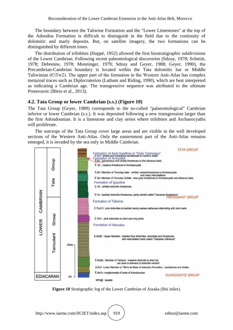
4.2. Tata Group or lower Cambrian (s.s.) (Figure 10)
The Tata Group (Geyer, 1989) corresponds to the so-called "palaeontological" Cambrian
inferior or lower Cambrian (s.s.). It was deposited following a new transgression larger than
the first Adoudounian. It is a limestone and clay series where trilobites and Archaeocyaths
will proliferate.
The outcrops of the Tata Group cover large areas and are visible in the well developed
sections of the Western Anti-Atlas. Only the easternmost part of the Anti-Atlas remains
emerged, it is invaded by the sea only in Middle Cambrian.
Figure 10 Stratigraphic log of the Lower Cambrian of Assaka (Ifni inlier).

Mohamed Yazidi, Khadija Kaid Rassou, Bouchra Razoki, Fouad Benziane, Abdelaziz Yazidi,
Saïd Chakiri, Zohra Bejjaji, Mohamed Allouza, Hassan El Hadi, Said Ettazarini
http://www.iaeme.com/IJCIET/index.asp 920 [email protected]
The transgression to the Lower Cambrian (s.s.) gradually invaded the Anti-Atlas towards
the east and south with some emersions giving deposits of conglomerates to the Ordovician
and Devonian (Robert-Charrue, 2006).
The transition from the Taliwine Formation to the Tata Group is as progressive as the
passage from the Adoudou Formation to that of Taliwine.
The Lower Cambrian type series includes, according to Boudda et al. (1979) "Upper
limestones", "Schisto-limestone series", "Shale series" and "Terminal sandstone".
For this study, the Tata Group corresponds to the succession formed by: the "Igoudine"
Formation or the "Upper Limestones" (Єi1), the "Amouslek" Clay and Carbonate Formation
(Єi2), the "Issafene" Formation schist (Єi3) and the Formation of "Asrir" corresponding to
"Terminal Sandstone" (Єi4).
4.2.1. Igoudine Formation or "Upper limestones" (Calcaires Supérieurs )
The Tata Group begins with an essentially carbonate series called "Upper limestones"
(“Calcaires Supérieurs ») (Choubert, 1952, Boudda et al., 1979) and noted (Єi1). This is the
Igoudine Formation (Geyer, 1989 and 1990). This Formation consists of two members: the
Lower Member (Єi1a) and the Upper Member (Єi1b). In fact, the Tata Group begins with
dolomitic limestones lying in semi-metric and marly-wedge beds or clayey limestones (Єi1a).
The thickness varies regionally and reaches about 300m in the Ifni inlier. Detrital sandstone to
microconglomerate levels slipped in between. Then come deposits of well-defined whitish
dolomitic limestones (Єi1b) (30 to 50 m). The Igoudine Formation shows through the Anti-
Atlas a lateral variation of facies and thickness.
To the east, sandstone and clay occur between the dolomitic limestone beds, and in the
extreme east the detrital facies dominate. The thickness of the Igoudine Formation can reach
500 to 600 m to the west. On the other hand in the east, it is only 75m and disappears to the
east of Saghro.
The Igoudine Formation was deposited under shallow marine conditions. Among the
trilobite and archaeocyath a fauna found in these limestones (Schmitt and Monninger, 1977 ;
Sdzuy et al., 1988), mention may be made of Eofallotaspis, Hupetina, Bigotina, Afiacyathus,
Coscinocyathus, etc.
4.2.2. Amouslek Formation
The Amouslek Formation (Єi2) is known as "Série Schisto-limestone" described by Choubert
(1952), then named Amouslek Formation (Geyer, 1989 and 1990). The unit is widespread in
the Anti-Atlas and extends about 220 m thick in the Amouslek section about 40 m south of
Jbel Kissane. The transition from Igoudine to the Amouslek Formation is a sudden change
from massive carbonates to shale / slate-carbonate. In this study, four members make up the
Amouslek Formation:
The first member is called Member of Timoulay Oufella (Єi2a). It corresponds to massive
limestones in white metric beds. Fossiliferous levels to Archaeocyatha characterize the
Formation.
The second member is Member of Timoulay Isder (Єi2b) with more marlish facies.
Decimetric to metric beds of white limestone and marl alternate. Reddish or greenish gray
nodular limestones with marly interbeds characterize the top of this member.
The third member (Єi2c) consists of massive limestones in amalgamated metric beds, with
rare marly joints. The limestones are of varied color: bluish black, gray or white and contain
Archaeocyathidae.
The fourth member (Єi2d) outcrops in the Ifni inlier. Outcrops are located at "Foum Fast" on
both banks of N'Fast wadi (Ait Sbouya sheet). Other outcrops are located on the banks of

Reconsideration of the Lower Cambrian Extension in the Anti-Atlas Belt, Morocco
http://www.iaeme.com/IJCIET/index.asp 921 [email protected]
Oued Arksis downstream (Assaka sheet). This member is represented by massive dark cloddy
limestones and interbedded shaly marl. The Єi2d generally constitutes the last reliefs that
envelop the Ifni inlier to the east and south.
The Amouslek Formation is about 200 m thick. Shaly levels provided trilobite fauna
(Hupé 1952 and 1953; Geyer, 1996). Abundant shellfish fossils are generally indicative of
Fallotaspididae (Fallotaspis, Choubertella, Daguinaspis) and Neoredlichiidae (eg, Resserops,
Marsaisia). Stromatolites and horizons to low amount of cyanobactéria are present in the
upper carbonated half cycle in many places and have been discussed at Jbel Kissane
(Buggisch et al., 1978).
4.2.3. Formation of Issafene or "Shale series" («Série Schisteuse )
The Issafene Formation (Geyer, 1989) corresponds to Choubert's « Série Schisteuse » (Єi3)
(1952). In the Issafene section type, this Formation consists essentially in shales and easily
recognizable in the landscape by its purplish color. In some areas, shales load in floated micas
and their thickness decrease. Their color is green and they are soft or fairly resistant in the
presence of volcanic material. The thickness of the Formation is about 400m around
Timdghas (Jebel Saghro). The thickness varies in Tata between 150m in the west and 75m in
the east, but it is reduced to 50m in Bou-Azzer area. This Formation can also be characterized
by "scoriaceous limestones", such as those observed in the cover of Ifni's inlier. These
scoriaceous limestones have been interpreted as diagenetically altered layers of volcaniclastic
sediments and fine-grained volcanoclastic sediments and calcareous interlayers (De Koning,
1957; Hupé, 1959).
The paleontological studies of this Formation are very old. In fact, the first recorded
African archeocenes were discovered in 1925 in massive bluish limestones of the Sidi Moussa
d'Aglou Formation (Bourcart, 1927). Boudda et al. (1979) defined Issafenian by its
archaeocyathic bioherms. The archeoliths of the Issafen Formation have been studied by.
Debrenne et al., (1975 and 1992).
4.2.4. Formation of Asrir or "Ultimate Sandstones" (Grès Terminaux )
The Asrir Formation is formerly called « Grès Terminaux » by Choubert (1942 and 1952),
then the Asrir Formation by the same author (1963) and taken over by Hollard (in Destombes
and al., 1985). For Geyer (1989a and 1990b) it is the Tazlaft Formation. For Landing (2006),
the Tazlaft Formation is traditionally assigned to the top of the Asrir Formation, and is
therefore only the lower part of the "Ultimate Sandstones" (Landing et al., 2006).
The Asrir Formation (Єi4) appears gradually over the Issafene Formation. It is
characterized by sandstone deposit. In the section type of Asrir, it is an alternation of
sandstone and shale whose thickness reaches 300 to 400m. Elsewhere, it is mostly sandstone
with intercalations of conglomerates and fine shaly beds, but the thickness does not exceed
100m. The trilobite fauna found in the levels of the Asrir Formation contains: Myopsolenus
[magnus] (Hupé 1953) and Gentilaspis (Hupé 1960).
This Formation outcrops almost continuously on the eastern and southern slopes of
Saghro. In the Western Anti-Atlas (Palaeozoic cover of Ifni's inlier), the Formations of
Issafene and Asrir consist both of terrigenous deposits and it is difficult to distinguish
between them. Both of them are grouped under the name of the Asrir-Issafene Formation
(Єi3-4), consisting of sandstones and siltstones, dark green to red color and containing
volcanic elements. The sandstone layers are decimetric to metric thick with silty joints and
interbeds. The siltstones are thin-bedded and micaceous and sometimes show intercalated
sandstone layers. Sometimes layers of coarse sandstone are intercalated in the siltstones. The
siltites show an alternation of predominantly clay beds and predominantly sandstone beds.

Mohamed Yazidi, Khadija Kaid Rassou, Bouchra Razoki, Fouad Benziane, Abdelaziz Yazidi,
Saïd Chakiri, Zohra Bejjaji, Mohamed Allouza, Hassan El Hadi, Said Ettazarini
http://www.iaeme.com/IJCIET/index.asp 922 [email protected]
The Formation of “Ultimate Sandstones” marks the end of the lower Cambrian cycle of
the Anti-Atlas.
5. GEOCHRONOLOGY OF EVENTS IN LOWER CAMBRIAN
The base of the Early Cambrian begins with the deposition of the Taroudant and Tata Groups
in conformity with the Precambrian rocks. The passage is marked only by a simple erosion
unconformity. The peritidal sedimentation, which shows the formations of Adoudou and
Taliwine, testifies to a beginning of opening which evolves towards the installation of a sea in
which proliferate trilobites and archaeocyatha. These are found in the deposits of the
Formations of Igoudine, Amouslek, Issafene and Asrir. The reef carbonate sedimentation also
testifies to a phase of global warming succeeding the Precambrian glaciation phase. In fact,
diamictites described in different regions of the Anti-Atlas have been interpreted as glaciation
witnesses (Vernhet et al., 2012, Letsch et al., 2018), two phases worth to be distinct.
The ancient dating of the Cambrian series concerns the lavas of Jbel Boho (Choubert,
1952, Boudda et al., 1979; Leblanc, 1973, 1975; Alvaro et al., 2006). These lavas are
intercalated in the "Lower Limestones". They were dated at 534 ± 10 Ma (Leblanc and
Lancelot, 1980). Among the ancient paleontological dating, we can mention the
paleontological discoveries of Buggisch and Flügel (1986) in the "Lower Limestones"
Recent stratigraphic and geochronological studies on the Anti-Atlas place the beginning of
the Adoudounian transgression around 545 Ma and place the upper age limit of this
transgression at 525-531 Ma (Gasquet et al., 2005, Maloof et al., 2005, Yazidi et al., 2016).
These age limits are based on dating volcanic flows in the dolomitic formations of
Adoudounian.
In the Bou-Azzer inlier, the trachytes of Aghbar have been dated to 531 ± 5 Ma by
Gasquet et al. (2005). While the Jebel Boho syenites are dated at 534 ± 10 Ma (Ducrot and
Lancelot, 1977). The syenite age is later recalculated to 529 ± 3 Ma (Gasquet et al., 2005).
We consider that the deposits in which the volcanic rocks are intercalated attest of an
extensive context (Figure 4).
The date of 534 ± 10 Ma on the Lower Adoudou Formation and revised interpretations of
chemostratigraphic data (Maloof et al., 2005) suggest that almost the entire Taroudant group
is Lower Cambrian.
Other datings (Yazidi et al., 2016 a, b) were made on the lower Cambrian formations of
the Ifni area. On the Talata Al Akhçaç Sheet, the detrital zircons of the Adounounian
sandstones (ЄiAd1) give an average age of less than 554 ± 3 Ma. On the Assaka sheet, the
sandstones of the Asrir-Issafene Formation (Єi3-4) dating of detrital zircons have yielded
minimum ages for the lower Cambrian 555 ± 8 Ma. The age of deposition of these units
containing reworked elements is decidedly newer.
Isotopic analyzes performed on volcanic tuffs and intercalations in Adoudounian and
Taliwinian (Ducrot and Lancelot, 1977; Compston et al., 1992; Landing et al., 1998; Gasquet
et al., 2005; Pouclet et al., 2008 ; Maloof et al., 2010) are of great importance. They confirm
our results on the study of the Lower Cambrian in the Anti-Atlas.
All these arguments confirm that it is from the Adoudounian and during the lower
Cambrian, the progressive occupation of the Anti-Atlas by the sea from the northwest took
place. This is an initial opening period. In addition, the formation of this basin was
accompanied by volcanic activities on its periphery and by a global warming favoring reef
carbonate sedimentation (Algouti et al. 2002).
The figure 11 represents a recapitulation of the correlations of the different parts of the
Lower Cambrian cover over the Precambrian formations of the Anti-Atlas. We have grouped
Reconsideration of the Lower Cambrian Extension in the Anti-Atlas Belt, Morocco
http://www.iaeme.com/IJCIET/index.asp 923 [email protected]
Adoudounian and Taliwinian into a lower Cambrian in the broad sense and not in any
terminal Neoproterozoic.
Figure 11 Summary Table and Correlation of Lower Cambrian Coverage Area.

Mohamed Yazidi, Khadija Kaid Rassou, Bouchra Razoki, Fouad Benziane, Abdelaziz Yazidi,
Saïd Chakiri, Zohra Bejjaji, Mohamed Allouza, Hassan El Hadi, Said Ettazarini
http://www.iaeme.com/IJCIET/index.asp 924 [email protected]
6. CONCLUSION
In conclusion, the stratigraphic interest of the Anti-Atlas is confirmed by these large
lithostratigraphic successions of the Paleozoic series. It is a sedimentary basin deposited in a
platform environment. Further, palaeontological and radiometric arguments suggest that the
Lower Cambrian is a period of progressive marine transgression on the Anti-Atlas from the
northwest. The evolution of this epicontinental basin has been a result of transgressive and
regressive fluctuations.
The lower Paleozoic forms the cover of the anti-atlasic Precambrian inliers during a
"rifting" phase. This allowed the transgression of the Taroudant Group and the Tata Group of
the Lower Cambrian. During the initial opening (Adoudounian), the formation of this basin
was accompanied by volcanic activities on its periphery.
The events that took place during the Adoudounian and the Taliwinian are part of the
same geodynamic process of continuous opening that is proposed to be attributed to the lower
Cambrian in the broad sense (s.l.) and not in any terminal or ultimate Neoproterozoic.
REFERENCES
[1] Algouti Ab., Algouti Ah., Chbani B. Etzaimz M. (2002) - Sédimentation et volcanisme
synsédimentaire de la série de base de l‟adoudounien infra-cambrien à travers deux
exemples de I‟Anti-Atlas du Maroc. Journal of African Earth Scrences. Vol. 32, NO. 4,
PP. 541-556.
[2] Álvaro, J. J. & Clausen, S. (2006). Processus de condensation dans les bioaccumulations
cambriennes de la Brèche à Micmacca, Atlas marocain. In: Réunion Spécialisée de la
Société Géologique de France, « Histoire et dynamique des plates-formes cabonatées et de
leurs biotas durant les Phanérozoïque », 18 & 19 Mai 2006, Livret des Résumes des
communications scientifiques, Université de Provence: 7; Marseilles.
[3] Alvaro, J. J., Clausen, S. (2008) - Paleoenvironmental significance of Cambrian hiatal
shell accumulations in an aborted intra-cratonic rift, Atlas Mountains, Morocco. In: Pratt,
B.R., Holmden, C. (Eds.), Dynamics of Epeiric Seas. Geol. Ass. Canada, Spec. Pap. 48,
pp. 39–54.
[4] Alvaro, J. J., Benziane F., Thomas R., Walsh G. Yazidi A. (2014) - Neoproterozoic–
Cambrian stratigraphic framework of the Anti-Atlas and Ouzellagh promontory (High
Atlas), Morocco. Journal of African Earth Sciences · October 2014.
[5] Benziane F., Prost A.E., Yazidi A. (1983) - Le passage du Précambrien au Cambrien
précoce volcanique et sédimentaire de l‟Anti-Atlas oriental ; comparaisons avec l‟Anti-
Atlas occidental. Bull. Soc. Géol. France 4, 549-556.
[6] Benziane, F., Yazidi, A., Walsh, G.J., Armstrong, T.R., Kouhen, M.A., Yazidi, M., El
Khamlichi, M.A., Aleinikoff, J.M. (2002) - Carte géologique du Maroc au 1/50 000,
feuille Afouzar. Notes et Mém. Serv. Géol. n° 422 bis, 1–72.
[7] Benziane, F. (2007) - Lithostratigraphie et évolution géodynamique de l‟Anti-Atlas
(Maroc) du Paléoprotérozoïque au Néoprotérozoïque: exemples de la boutonnière de
Tagragra de Tata et du Jbel Saghro. PhD. Univ. Savoie, France.
[8] Benziane F., Yazidi A., Yazidi M ; Saadane A., Walsh J.C. (2008) - Carte géologique du
Maroc, feuille au 1/50 000 QAL‟AT MGOUNA. Notes et Mémoires du Service
Géologique du Maroc n° 468.
[9] Benziane, F., Yazidi, A., Saadane, A., Yazidi, M., El Fahssi, A., Stone, B.D., Walsh, G.J.,
Burton, W.C., Aleinikoff, J.N., Ejjaouani, H., Kalai, M. (2008) - Carte géologique au1/50
000, Feuille Qal‟at Mgouna. Notes et Mémoires du Service Géologique du Maroc n° 468,
1–139.
Reconsideration of the Lower Cambrian Extension in the Anti-Atlas Belt, Morocco
http://www.iaeme.com/IJCIET/index.asp 925 [email protected]
[10] Benziane F., Yazidi A., Schulte B., Boger S., Stockhammer S., Lehmann A., Saadane A.,
Yazidi M. (2016) - Carte géologique du Maroc, feuille au 1/50 000 Tlata Al Akhçaç.
Notes et Mém. Serv. Géol. Maroc- Rabat n° 543bis.
[11] Bertrand-Sarfati, J. (1981) - Problème de la limite Précambrien –Cambrien: la section de
Tiout (Maroc); les stromatolites et leur biostratigraphie (Schmitt, 1979): critiques et
observations. Newsl. Stratigr. 10, 20–26.
[12] Blein O., Razin P., Baudin T., Chevermont P., Gasquet D., Soulaimani A., Admou H.,
Youbi N., Bouabdelli M., Anzar C. (2013) - Notice de la carte géologique du Maroc au
1/50 000 feuille Alougoum. Notes et mémoires du service géologique n°534 bis.
[13] Boudda A. Choubert G., Faure–Muret A. (1979) - Essai de stratigraphie de la couverture
sédimentaire de l‟Anti-Atlas : Adoudounien – Cambrien inferieur. Notes et Mém. Serv.
Géol. Maroc, N°271.
[14] Bourcart, J. (1927). Découverte du Cambrien à Archaeocyathus dans l‟Anti-Atlas
marocain. Comptes Rendus sommaire, Société géologique de France 1927 (1-2): 10–11,
Paris.
[15] Buggisch, W., Marzela C. & Hügel, P. (1978). Die fazielle und paläogeographische
Entwicklung der infrakambrischen bis ordovizischen Sedimente im Mittleren Antiatlas um
Agdz (S-Marokko). Geologische Rundschau 68 (1): 195–224, Stutt-gart.
[16] Buggisch W. & Flügel E. (1986). The Precambrian/Cambrian boundary in the Anti-Atlas
(Morocco). Discussion and new results. In: V. .JACOBSHAGEN Ed., The atlas system
of Morocco , Springer-Ver-lag, 81-90.
[17] Buggisch, W., Flugel, E. (1988) - The Precambrian/Cambrian boundary in the Anti-Atlas
(Morocco). Discussions and new results. In: Jacobshagen, V.H. (Ed.), The Atlas System
of Morocco. Studies on its Geodynamic Evolution. Lect. Not. Earth Sci. 15, pp. 81–90.
[18] Choubert G. (1942) - Signification tectonique du seuil du Siroua et du bloc oriental du
massif central du Haut-Atlas: Bulletin de la Société des Sciences Naturelles du Maroc, 22,
pp. 126-136.
[19] Choubert G. 1952. Histoire géologique du domaine de l‟AntiAtlas. Notes et Mém. Serv.
géol. Maroc, 100, 77 p.
[20] Choubert G., Marçais J. (1952) - Aperçu structural In: Géologie du Maroc Notes et Mém.
Serv. Géol. Maroc, 100, fasc 1, partie 1 –et : 19ème Congr. Géol. Int, Alger 1952, Monogr
région, 3ème série Maroc, 6, pp 9 – 73.
[21] Choubert, G., Faure Muret, A. (1962) - Evolution du domaine atlasique marocain depuis
les temps paléozoïques, Livre à la mémoire du Professeur Paul Fallot. Société géologique
de France, Paris, pp. 447-527.
[22] Choubert G. (1963) - Histoire Géologique du Précambrien de l'Anti-Atlas. Notes et Mém.
Serv. Géol. Maroc, N°162, 352p.
[23] Choubert G., Faure Muret A. (1970) - Colloque international sur les corrélations du
Précambrien, Agadir-Rabat, 3-23 mai 1970 et livret guide de l‟excursion : Anti-Atlas
occidental et central. Notes et Mém. Serv. Géol. Maroc. 229, 259p.
[24] Choubert, G., Destombes, J., Gauthier, H., Hindermeyer, J. (1980) - Carte géologique du
Maroc, feuille Jbel Saghro-Dadès (Haut Atlas central, sillon Sud-Atlasique et Anti-Atlas
oriental) au 1/200 000ème.
[25] Choubert G., Faure-Muret, A. (1983) - Anti-Atlas. In: Fabre, J. (Ed.), Afrique de l‟Ouest.
Introduction géologique et termes stratigraphiques. Pergamon, Oxford, pp. 80– 95.
[26] Cohen K.M., Finneys C., Gibbard P.L. (2018) - International Commission on
Stratigraphy.

Mohamed Yazidi, Khadija Kaid Rassou, Bouchra Razoki, Fouad Benziane, Abdelaziz Yazidi,
Saïd Chakiri, Zohra Bejjaji, Mohamed Allouza, Hassan El Hadi, Said Ettazarini
http://www.iaeme.com/IJCIET/index.asp 926 [email protected]
[27] Compston W., Williams I.S., Kirshvink J.L, Zhichao, Zhang, Guogan, Ma. (1992): Zircon
U–Pb ages from the Early Cambrian timescale. J. Géol. Soc. London, 149, 171-184.
[28] Cornée A. (1989).- Communautés benthiques à cyanobactéries des milieux hypersales :
Intérêt Géologique. Bull. Soc. Bot. Fr., 136, Actual. Bot., (1), p. 131-145.
[29] Dallmeyer, R.D., Lecorche, J.P. (EDS.) (1991) - The West African Orogens and Circum-
Atlantic Correlatives. IGCP Projet233.ix+405pp.
[30] Debrenne, F. et Debrenne, M. (1975). Age des premières et dernières faunes
d‟Archaeocyates du Cambrien inférieur du Maroc. Réunion de la Groupe Trav. Limite
Précambrien - Cambrien, Maroc, 23. Ok t.–2. Nov. 1975, 7 p., Rabat.
[31] Debrenne, F. et Debrenne, M. (1978). Archaeocyathid fauna of the lowest fossiliferous
levels of Tiout (Lower Cambrian –Southern Morocco). Geological Magazine 115 (2):
1101–119, London.
[32] Debrenne, F., Debrenne, M. & Faure-Muret A. (1992). Faune d‟Archéocyathes de l‟Anti-
Atlas occidental (bordures Nord et Sud) et du Haut Atlas occidental. Cambrien inférieur,
Maroc. Géologie Méditerranéenne XVII [for 1990] (3-4): 177–211, Aix-en-Provence.
[33] Destombes, J., Hollard, H., Willefert, S. (1985) - Lower Palaeozoic rocks of Morocco. In:
Holland, C.H. (Ed.), Lower Palaeozoic Rocks of the World. Lower Palaeozoic of North-
Western and West Central Africa, vol. 4. John Wiley and Sons, Chichester, pp. 57–184.
[34] De Koning, G. (1957). Géologie des Ida ou Zal (Maroc). Stratigraphie, pétrographie et
tectonique de la partie SW du bloc occidental du Massif ancien du Haut Atlas. Ph. D.
dissertation, Univ. Leiden, 209 p., Leiden.
[35] Ducrot J., Lancelot J. R. (1977) - Problème de la limite Précambrien-Cambrien : Etude
radiochronologique par la méthode U-Pb sur zircons du volcan du Jbel Boho (Anti-Atlas
marocain). Can. J. Earth. Sci. 14, p. 2771-3777.
[36] Gasquet D., Levresse G., Cheilletz A., Azizi Samir M.R., Mouttaqi A. (2005) -
Contribution to the geodynamic reconstitution of the Anti6atlas (Morocco) during
Panafrican times with the emphasis on inversion tectonics and metallogenic activity at the
Precambrian-Cambrian transition. Precambrian researth 2587 1-26.
[37] Gentil, L. (1912). Le Maroc physique. Paris, librairie f. Alcan, 313 pp., cartes.
[38] Geyer, G., (1989) - Late Precambrian to early Middle Cambrian lithostratigraphy of
southern Morocco. Beringeria 1, 115–143.
[39] Geyer, G. (1990 a) - Proposal of formal lithostratigraphical units for the Terminal
Proterozoic to early Middle Cambrian of southern Morocco. Newsl. Stratigr. 22, 87–109.
[40] Geyer, G. (1990 b) - Revised Lower to lower Middle Cambrian biostratigraphy of
Morocco. Newsl. Stratigr. 22, 53–70.
[41] Geyer, G. (1996). The Moroccan fallotaspidid trilobites revisited. Beringeria 18: 89–199,
Würzburg.
[42] Geyer, G., & Landing, E. (1995). The Cambrian of the Moroccan Atlas regions. In: Geyer,
G. & Landing, E. (eds.). Morocco „95 - the Lower–Middle Cambrian standard of western
Gondwana. Beringeria Special Issue 2: 7–46, Würzburg.
[43] Geyer, G. & Landing. E. (2004) - A unified Lower–Middle Cambrian chronostratigraphy
for West Gondwana. Acta Geologica Polonica 54: 197–218, Warsaw.
[44] Geyer, G., Landing, E. (EDS.). (2006) - Morocco 2006. Ediacaran–Cambrian depositional
environments and stratigraphy of the western Atlas regions. Explanatory description and
field excursion guide Special Issue 6.UCL Maghreb Petroleum Research Group (MPRG)
Infracambrian/Early Palaeozoic Field Guide Series No. 1.

Reconsideration of the Lower Cambrian Extension in the Anti-Atlas Belt, Morocco
http://www.iaeme.com/IJCIET/index.asp 927 [email protected]
[45] Geyer, G., Landing, E., (2016) - The Precambrian–Phanerozoic and Ediacaran–Cambrian
boundaries: a historical approach to a dilemma. In: Brasier, A.T., McIlroy, D.,
McLoughlin, N. (Eds.), Earth System Evolution and Early Life: A Celebration of the
Work of Martin Brasier. Geological Society, London, Special Publications, pp.
448.doi.org/10.1144/SP448.10.
[46] Harrison, R.W., Yazidi, A., Benziane, F., Quick, J.E., El Fahssi, A., Stone, B.D., Yazidi,
M., Saadane, A., Walsh, G.J., Aleinikoff, J.N., Ejjaouani, H., Kalai, M., (2008) - Carte
géologique au 1/50 000, Feuille Tizgui. Notes et Mémoires Service Géologique Maroc. N°
470, 1–131.
[47] Hupé P. (1952) - contribution à l‟étude du Cambrien inferieur et du Précambrien III de
l‟Anti-Atlas marocain. Notes et Mém. Serv. Géol. du Maroc. N°103.
[48] Hupé, P. (1953). Contribution a l‟étude du Cambrien inférieur et du Précambrien iii de
l‟Anti-Atlas marocain. Notes et mémoires du service géologique du Maroc 103, 402 p.,
Bagnolet, seine (1952).
[49] Hupé, P. (1959). Nouvelle contribution à l‟étude du Cambrien marocain. Thèse
Scientifique, Faculté des Sciences, Université de Paris, 447 p., Paris.
[50] Hupé, P. 1960. Sur le Cambrien inférieur du Maroc. Reports of the XXIth International
Geological Congress, Norden 1960, 8, 8. Late Pre-Cambrian and Cambrian stratigraphy:
75–85, Copenhagen.
[51] Landing E., Bowring S.A., Davidek K.L., Westrop S.R., Geyer G., Heldmaier W. (1998) -
Duration of the early cambrian: U–Pb ages of volcanic ashes from Avalon and Gondwana.
Canadien Journal of Earth Science 35, 329–338.
[52] Landing, E., Geyer, G. & Heldmaier, W. (2006). Distinguishing eustatic and epeirogenic
controls on Lower–Middle Cambrian boundary successions in West Gondwana (Morocco
and Iberia). Sedimentology: 53: 899–918, London.
[53] Landing Ed., Antcliffeb J. B., Geyerc G., Kouchinskyd A., Bowsere S., Andrease A.
(2018) - Early evolution of colonial animals (Ediacaran Evolutionary Radiation–Cambrian
Evolutionary Radiation–Great Ordovician Biodiversification Interval). Earth-Science
Reviews 178 (2018) 105–135.
[54] Latham, A. & Riding, R. (1990). Fossil evidence for the location of the
Precambrian/Cambrian boundary in Morocco. Nature 344 (6268): 752–754, London.
[55] Leblanc M. (1973) - Les formations infracambriennes de Bou-Azzer (Anti-Atlas, Maroc):
lithostratigraphie, tectonique et position structurale. Notes et Mém. Serv. Géol. Maroc,
t.34, n° 254, pp. 7-14.
[56] Leblanc, M. (1975) - Ophiolites Précambriennes et gîtes arseniés de cobalt (Bou Azzer,
Maroc). Centre Géologique et Géophysique Montpellier, Mém. Hors - Serie, 329 p.
[57] Leblanc, M. & Lancelot, J. R. (1980). Interprétation géodynamique du domaine
panafricain (Précambrien terminal) de l‟Anti-Atlas (Maroc) à partir de données
géologiques et éochronologiques. Canadian Journal of Earth Sciences 17: 142–155,
Ottawa.
[58] Letsch D., El Houicha M., Von Quadt A. and Wilfried Winkler W. (2018) A missing link
in the peri-Gondwanan terrane collage: the Precambrian basement of the Moroccan
Meseta and its lower Paleozoic cover.
[59] Maloof, A.C., Schrag, D.P., Crowley, J.L. and Bowring, S.A. (2005) - An expanded
record of Early Cambrian carbon cycling from the Anti-Atlas Margin, Morocco, Canadian
Journal of Earth Sciences , 42 pp. 2195-2216.

Mohamed Yazidi, Khadija Kaid Rassou, Bouchra Razoki, Fouad Benziane, Abdelaziz Yazidi,
Saïd Chakiri, Zohra Bejjaji, Mohamed Allouza, Hassan El Hadi, Said Ettazarini
http://www.iaeme.com/IJCIET/index.asp 928 [email protected]
[60] Maloof A.C., Ramezani J., Bowring S.A., Fike D.A., Porter S.M., Mazouad M. (2010) -
Constraints on early Cambrian carbon cycling from the duration of the Nemalit-
Daldynian–Tommotian boundary d13C shift, Morocco. Geology, 38, 623–626.
[61] Monninger, W. (1979). The section of Tiout (Precambrian/Cambrian boundary beds, Anti-
Atlas, Morocco): An environmental model. Arbeiten aus dem Paläontologischen Institut
Würzburg 1: 289 p., Würzburg.
[62] Pique, A. (2001) - Geology of Northwest Africa. Regional en Geologie der Erde, Vol. 29.
Translated by M. S. N. Carpenter. 310 pp. Berlin, Stuttgart.
[63] Pouclet A., Ouazzani H., Fekkak A. (2008) - The Cambrian volcanosedimentary
formations of the westernmost High Atlas (Morocco) : their place in the geodynamic
evolution of the West African Palaeo-Gondwana northern margin. In: Ennih, N., Liegeois,
J.P. (Eds.), The Boundaries of the West African Craton.Geol. Soc., 297. Spec. Publ.,
London, pp. 303–327.
[64] Pouclet A., El Hadi H., Álvaro J.J., Bardintze J.-M., Benharref M., Fekkak A. (2018) -
Review of the Cambrian volcanic activity in Morocco: geochemical fingerprints and
geotectonic implications for the rifting of West Gondwana. International Journal of Earth
Sciences.
[65] Robert-Charrue C. (2006) - Géologie structurale de l'Anti-Atlas oriental, Maroc. Thèse de
doctorat Université de Neuchâtel.
[66] Schmitt, M., Monninger, W., (1977) - Stromatolites and thrombolites in
Precambrian/Cambrian boundary beds of the Anti-Atlas, Morocco: preliminary results. In:
Flugel, E. (Ed.), Fossil Algae. Springer, Berlin, pp. 80–85.
[67] Schmitt, M. 1978. Stromatolites from the Tiout section, Precambrian–Cambrian boundary
beds, Anti-Atlas, Morocco. Geological Magazine Special issue 115 (2): 95–99,
Cambridge.
[68] Sdzuy K. (1978) : The Precambrian-cambrian boundary beds in Morocco (Preliminary
Report). Geol. Mag., 115 (2), 83-94.
[69] Sdzuy, K. & Geyer, G. (1988). The base of the Cambrian in Mo-rocco. In: Jacobshagen,
V. H. (ed.). The Atlas System of Morocco. Studies on its Geodynamic Evolution. Lecture
Notes in Earth Sciences 15: 91–106, Berlin, Heidelberg, New York, London, Paris, Tokyo
(Springer).
[70] Soulaimani A., Bouabdelli M. (2003) - L'extension continentale au Néo-Protérozoïque
supérieur-Cambrien inférieur dans l'Anti-Atlas (Maroc). Bull. Soc. géol. Fr. no1.
[71] Soulaimani A., Blein O., Chevremont Ph., Ouanaimi H., Hafid A., Admou H., Baudin T.,
Bouabdelli M., Razin Ph., Abia E.H., Beni Akhy R. (2013) - Carte géologique du Maroc
au 1/50 000 Feuille Agadir Melloul. Notes et Mémoires du Service Géologique du Maroc
N°549bis.
[72] Soulaimani, A., Michard A., Baidder L., Ouanaimi H., Raddi Y. (2014) - Ediacaran-
Cambrian structures and their reactivation during the Variscan and Alpine cycles in the
Anti-Atlas (Morocco). J. Afr. Earth Sci.
[73] Vernhet E., Youbi N., Chellai E.H., Villeneuve M., El Archi A. (2012) - The Bou-Azzer
glaciation: Evidence for an Ediacaran glaciation on the West African Craton (Anti-Atlas,
Morocco). Precambrian Research 196– 197 (2012) 106– 112.
[74] Walsh, G.J., Aleinikoff, J.N., Benziane, F., Yazidi, A., Armstrong, T.R. (2002) - U–Pb
zircon geochronology of the Paleoproterozic Tagragra de Tata inlier and its
Neoproterozoic cover, western Anti-Atlas, Morocco. Precambr. Res. 117, 1–20.

Reconsideration of the Lower Cambrian Extension in the Anti-Atlas Belt, Morocco
http://www.iaeme.com/IJCIET/index.asp 929 [email protected]
[75] Walsh G.J., Yazidi A., Benziane F., Burton W.C, Yazidi M., Saadane A. (2008) - Carte
géologique du Maroc, feuille au 1/50 000 Timdghas. Notes et Mémoires Serv. Géol.
Maroc 468.
[76] Walsh G.J., Benziane F., Yazidi A., Burton W.C, Yazidi M., Saadane A. (2008) - Carte
géologique du Maroc, feuille au 1/50 000 Bouskour. Notes et Mémoires Serv. Géol.
Maroc 469.
[77] Yazidi, A., Benziane, F., Walsh, J., Harrison, R.W., Saadane, A., Yazidi, M., Quick, J.E.,
El Fashssi, A., Stone, B.D., Aleinikoff, J.N., Ejjaouani, H., Kalai, M. (2002) - Carte
géologique du Maroc (1/50 000), feuille Zawyat Si Nisser. Not. Mém. Serv. Géol. Maroc.
423, 69.
[78] Yazidi A., Benziane F., Quick J.E., Yazidi M., Saadane A., Walsh G.J. (2008) - Carte
géologique du Maroc, feuille au 1/50 000 Ait Semgane. Notes et Mém. Serv. Géol.
Maroc- Rabat n° 472.
[79] Yazidi A., Benziane F., Schulte B., Boger S., Stockhammer S., Lehmann A., Saadane A.,
Yazidi M. (2016) - Carte géologique du Maroc, feuille au 1/50 000 Assaka. Notes et
Mém. Serv. Géol. Maroc- Rabat n° 544bis.
[80] Yazidi A., Benziane F., Schulte B., Boger S., Stockhammer S., Lehmann A., Saadane A.,
Yazidi M. (2016) - Carte géologique du Maroc, feuille au 1/50 000 Aït Sbouya. Notes et
Mém. Serv. Géol. Maroc- Rabat n° 545bis.