Embed Size (px)
Citation preview
Town Planning Report
Reconfiguration of a Lot Boundary
Realignment (2 Lots into 2 Lots) – on land at
Glendaragh Road, FARLEIGH
4740, more formally described as
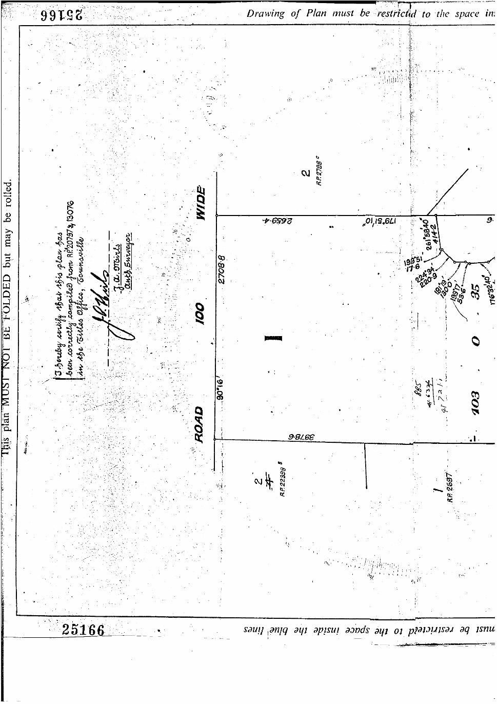
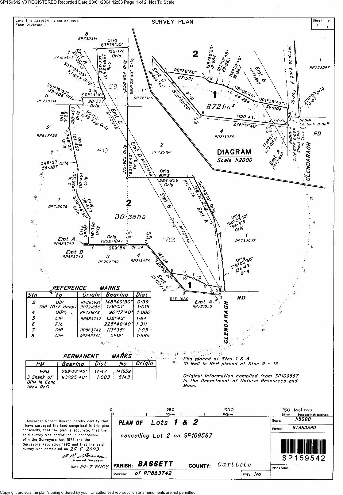
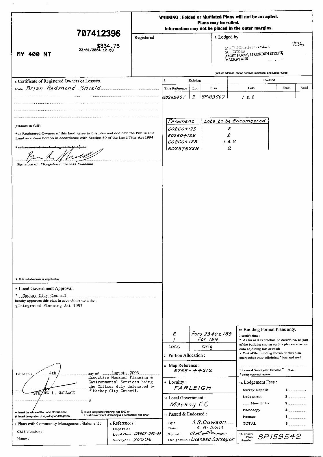
Lot 2 on SP159542
Lot 2 on RP725166 on behalf of
Brian and Thelma Shield
Date: February, 2014
PREPARED BY:
VISION SURVEYS QLD PO BOX 1730 MACKAY QLD 4740
JOB NUMBER: 14016
SMART EDA: 1391138505138
P: 07 4951 0768 F: 07 4953 03440 E: [email protected] W: http://www.visionsurveysqld.com.au/
Town Planning Report Boundary Realignment - 2 into 2
0 Glendaragh Road, Farleigh Page 2 of 10 14016 | February 2014
TABLE OF CONTENTS
1.0 SITE INFORMATION .......................................................................................................................... 3
2.0 APPLICATION DETAILS.................................................................................................................... 3
3.0 SITE FEATURES ................................................................................................................................ 4
4.0 BACKGROUND .................................................................................................................................. 5
4.1 Prelodgement Meeting ................................................................................................................ 5
5.0 PROPOSAL ........................................................................................................................................ 6
6.0 PLANNING ASSESSMENT ................................................................................................................ 8
6.1 Mackay City Planning Scheme 2006 .......................................................................................... 8
7.0 STATUTORY PLANNING ASSESSMENT ......................................................................................... 9
7.1 Assessment Manager ................................................................................................................. 9
7.2 Referral Agencies ....................................................................................................................... 9
7.3 Public Notification ....................................................................................................................... 9
8.0 CONCLUSION .................................................................................................................................. 10
APPENDIX
Appendix A - Current Title Search, Survey Plan, Smart Map & Owners Consent
Appendix B - Proposal Plan, Site Analysis Plan
Appendix C - IDAS Form 1, IDAS Form 7
Appendix D - Rural Zone Code
Appendix E - Environment and Infrastructure Code
Appendix F - Reconfiguration of a Lot Code
Appendix G - Frame Locality Code
Appendix H - Bushfire Management Overlay Code
Appendix I - Steep Land Overlay Code
Appendix J - Overlay Mapping
Appendix K - Prelodgement Meeting Request Form (MRC)
Appendix L - Prelodgement Advice DSDIP (SPL-0114-007589)
Appendix M - Vegetation Mapping, Strategic Cropping Land Mapping , Coastal Management Areas and Coastal
Hazard Mapping
Appendix N - SDAP Module 6.1
DOCUMENT MANAGEMENT
Version Job Number
Date Completed
Author Author initials
Reviewer Date Reviewed Reviewer initials
Draft v1 14016 28/01/2014 Marcus Fossey MF Michael Rudder 29/01/2014 MR
Draft v2 14016 28/01/2014 Marcus Fossey MF Brian Forrester 05/02/2014 BF
Final 14016 12/02/2014 Marcus Fossey MF

Town Planning Report Boundary Realignment - 2 into 2
0 Glendaragh Road, Farleigh Page 3 of 10 14016 | February 2014
1.0 SITE INFORMATION The major site details are as follows:
Site Details
Site Address Glendaragh Road, FARLEIGH,
Real Property Description
Site Area
Land Owner
(refer to Appendix A – CTS)
Lot 2 on SP159542
30.38ha
Brian Shield
Lot 2 on RP725166
20.017ha
Thelma Shield
Brian Shield
Contact Persons Marcus Fossey Vision Surveys QLD [email protected]
2.0 APPLICATION DETAILS An overview of the application details are provided below:
Application Detail
Approval Sought Development Permit for a Reconfiguration of a Lot – Boundary Realignment of
2 Rural Lots into 2 Rural Lots
Level of Assessment Code
Planning Scheme Definition Reconfiguration of a Lot
Local Planning Scheme Mackay City Planning Scheme 2006
Zoning Rural (Refer to Figure 1 – Zoning Plan)
Planning Locality Frame Locality
Planning Precinct Goosepond Creek
Applicable Codes Scheme Codes
Rural Zone Code
Environment and Infrastructure
Code
Frame Locality Code
Rural Zone Code
Overlay Codes
Bushfire Management Overlay Code
Development on Steep Land Overlay
Code
Landscape Character Overlay Code
GQAL Overlay Code
Regional Plan Classification Regional Landscape & Rural Production Area
(Mackay, Isaac and Whitsunday Regional Plan)
Assessment Manager Mackay Regional Council
Referrals Department of State Development Infrastructure and Planning
(Ergon Energy)
Public Notification None
Town Planning Report Boundary Realignment - 2 into 2
0 Glendaragh Road, Farleigh Page 4 of 10 14016 | February 2014
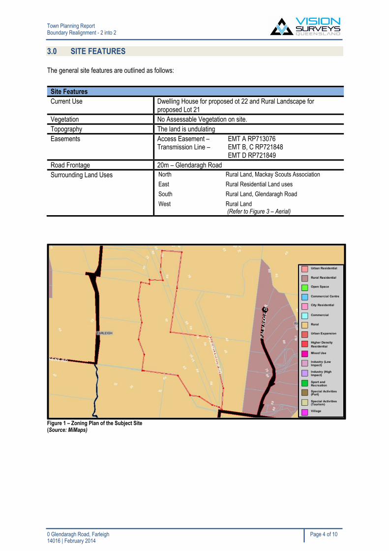
3.0 SITE FEATURES
The general site features are outlined as follows:
Site Features
Current Use Dwelling House for proposed ot 22 and Rural Landscape for proposed Lot 21
Vegetation No Assessable Vegetation on site.
Topography The land is undulating
Easements Access Easement – EMT A RP713076 Transmission Line – EMT B, C RP721848 EMT D RP721849
Road Frontage 20m – Glendaragh Road
Surrounding Land Uses North Rural Land, Mackay Scouts Association
East Rural Residential Land uses
South Rural Land, Glendaragh Road
West Rural Land (Refer to Figure 3 – Aerial)
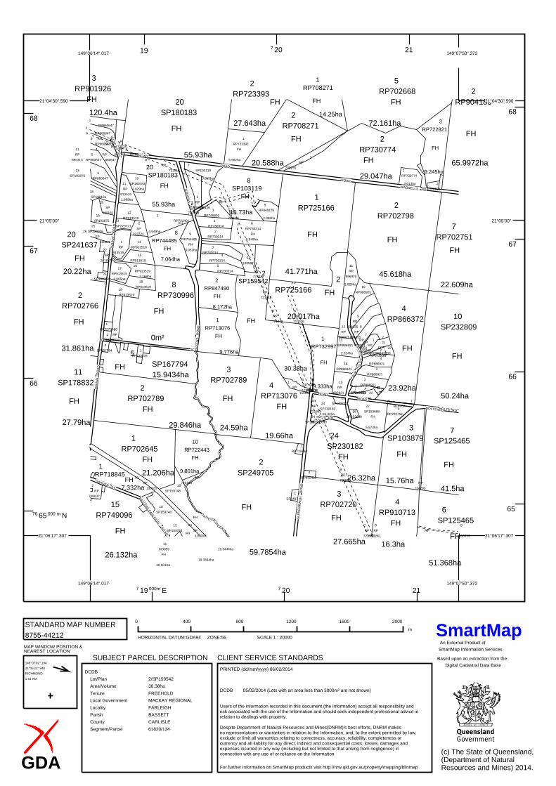
Figure 1 – Zoning Plan of the Subject Site (Source: MiMaps)
Town Planning Report Boundary Realignment - 2 into 2
0 Glendaragh Road, Farleigh Page 5 of 10 14016 | February 2014
4.0 BACKGROUND
4.1 Prelodgement Meeting
Mackay Regional Council
The proposal was recently discussed with Mackay Regional Council Principal Planner Leah Harris on the 22nd
January 2014. Refer to Appendix K for the prelodgement meeting request. The general comments from the
meeting are as follows –
MRC can support the boundary realignment due to the simplicity of the alignment for land management purposes;
As long as there are no significant changes to the cadastre the proposal is considered acceptable;
Department of State Development Infrastructure and Planning
Vegetation Matters
Written advice was requested from DSDIP regarding the remnant vegetation containing endangered regional
ecosystems. DSDIP have mentioned the application does not require a referral as per their correspondence in
Appendix L – DSDIP Prelodgement Advice attached to the Town Planning Report.
Town Planning Report Boundary Realignment - 2 into 2
0 Glendaragh Road, Farleigh Page 6 of 10 14016 | February 2014
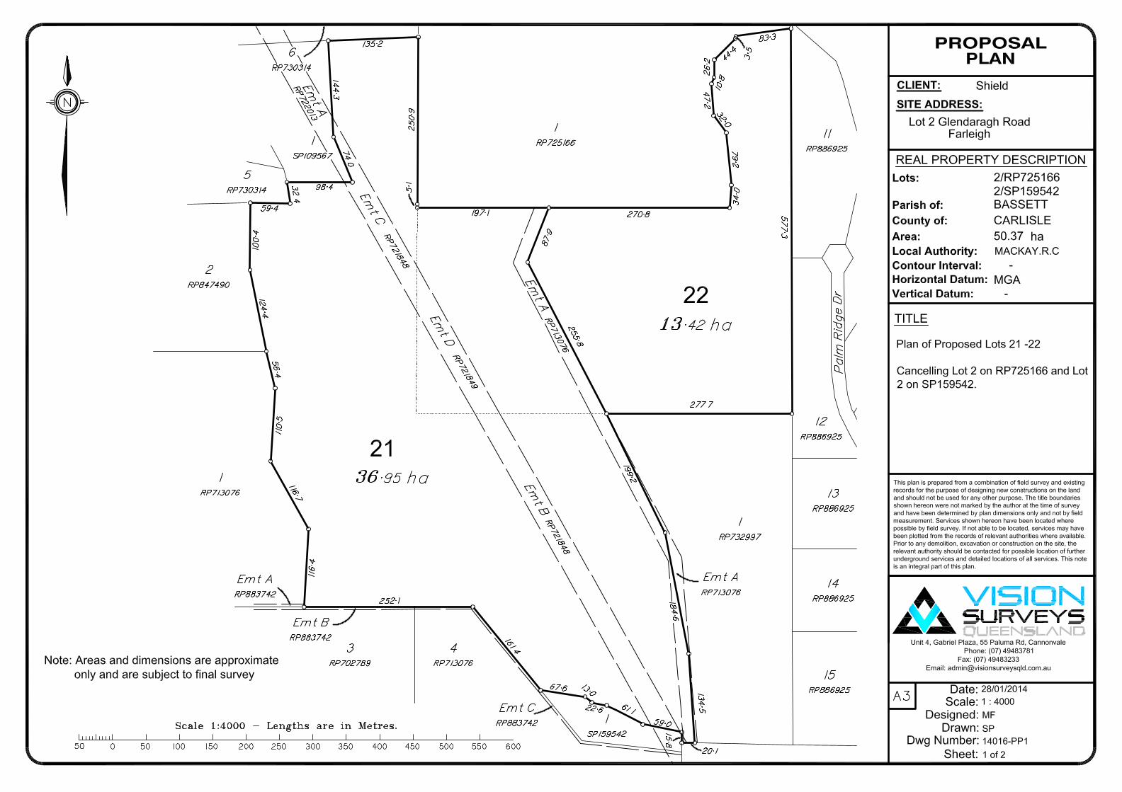
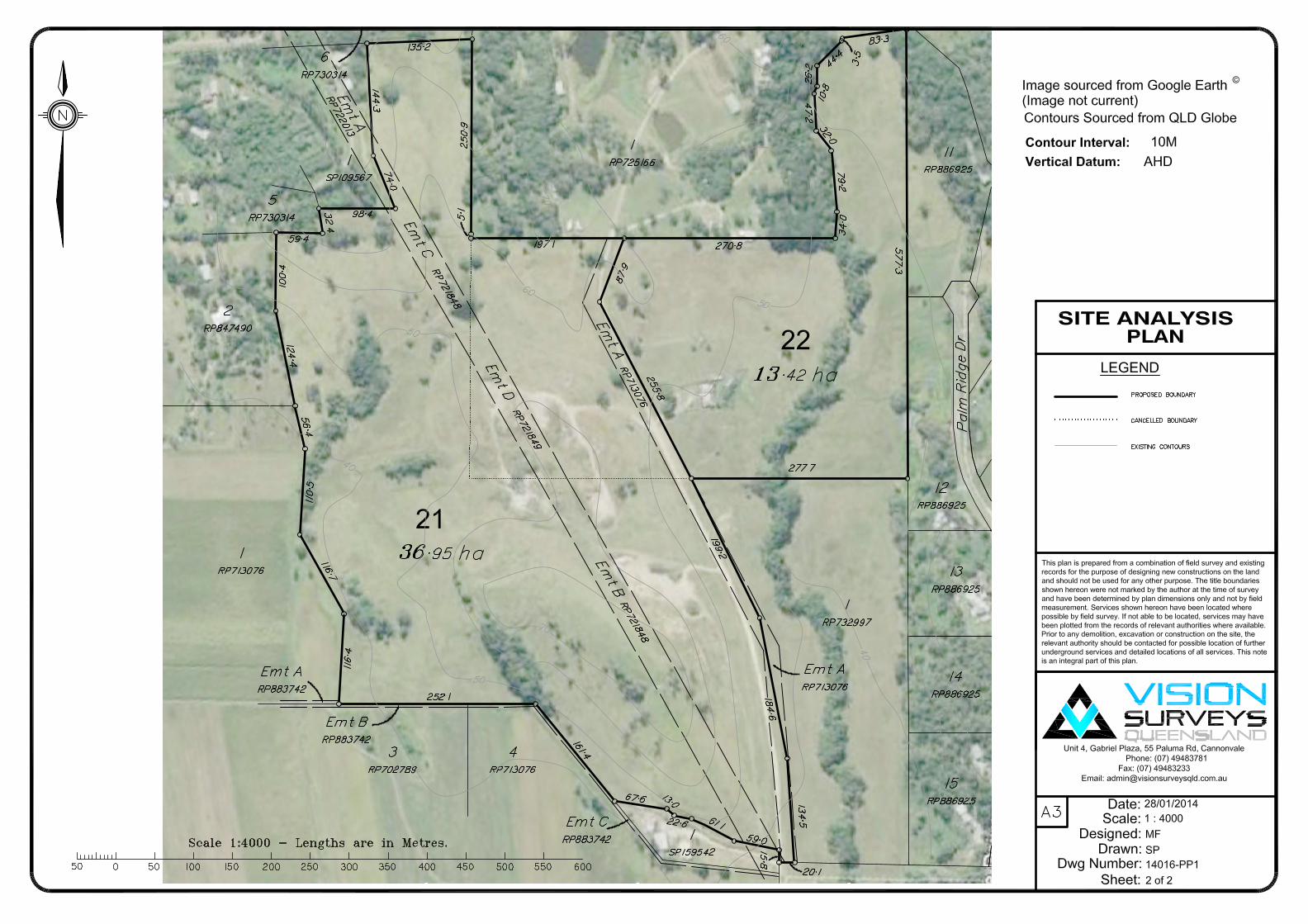
5.0 PROPOSAL The applicant, Brian and Thelma Shield seek to obtain a Development Permit for a Reconfiguration of a lot, Boundary Realignment of 2 Lots into 2 Lots over the subject land being, Lot 2 on SP159542 and Lot 2 on RP725166, Glendaragh Road, Farleigh. The proposed development will realign property boundaries generally in accordance with Appendix B – Proposal Plan. The application is based upon a land management and titling purposes for the applicant. Specifically, the purpose of the realignment will be to contain the access easement (Emt A RP713076) on the one title. There will be a transfer of approximately 6.5ha from Lot 2 on RP725166, (to be known as Lot 22) to Current Lot 2 on SP159542 (to be known as Lot 21). The major points that will assist the Assessment Manager’s assessment pertaining to the proposed boundary realignment are as follows:
The realignment will ensure the access easement is completely on one title (being proposed Lot 21);
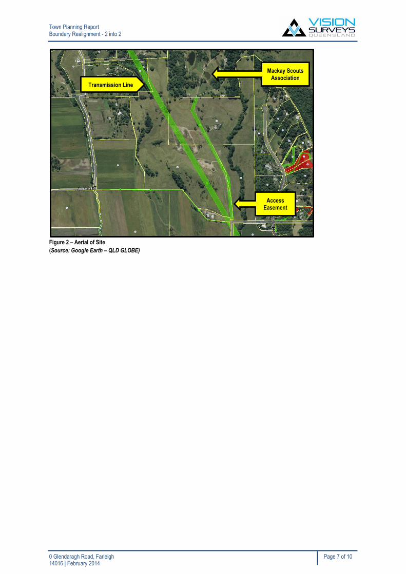
The access easement is in favour of the Lot to the north (Lot 1 on RP725166 – refer to Smart Map,
Figure 2). The lot to the North is the Mackay Scouts Association;
The existing use on Lot 22 is a domestic dwelling (there are no changes to this use);
The existing use on Lot 21 is rural landscaped land (there are no changes to this use);
The transfer of land is approximately 6.5ha (refer to Appendix B – Proposal Plan).
The proposed allotment sizes and frontages are listed in the tables below: Table 1: Proposed Lot Sizes
Services
A brief overview of the infrastructure is outlined below. Due to the small scale the realignment it is considered
conditioning the application with infrastructure requirements is not applicable.
Sewerage Proposed Lot 21 does not have any services on it. Proposed Lot 22 current has adequate sewer.
Access Access will remain in its current extent for both allotments. Access will be achieved from the EMT A – RP713076 which is the existing access easement.
Water Supply Proposed Lot 21 does not have any services on it. Proposed Lot 22 will maintain its current water supply.
Electricity and Telecommunications
Proposed Lot 22 maintains current electricity and telecommunications. There is no connections on Lot 21
Stormwater Stormwater drainage will remain in its current extent. No provisions are considered applicable for stormwater management.
Area of Proposed Lots
Proposed Lot 21 36.95ha
Proposed Lot 22 13.42ha
Town Planning Report Boundary Realignment - 2 into 2
0 Glendaragh Road, Farleigh Page 7 of 10 14016 | February 2014
Figure 2 – Aerial of Site
(Source: Google Earth – QLD GLOBE)
Transmission Line
Access Easement
Mackay Scouts
Association
Town Planning Report Boundary Realignment - 2 into 2
0 Glendaragh Road, Farleigh Page 8 of 10 14016 | February 2014
6.0 PLANNING ASSESSMENT Planning Summary The proposal seeks to relocate the boundary to ensure the access easement is wholly contained on the one title. It is also considered this is a positive outcome for the property owners, as it will aid in the land management for the future of the site. The boundary realignment better aligns the cadastre to suit the access easement. It is envisaged there are limited planning issues associated with this proposal as the reconfiguration is very small scale and no uses are being changed on either title. Such overlay codes such as Landscape Character and GQAL are not considered relevant to the application. However they have been briefly addressed in section 6.1.
6.1 Mackay City Planning Scheme 2006 The proposed reconfiguration is subject to a Code Assessable application involving an assessment against the applicable codes of the Mackay City Planning Scheme 2006. The Code Compliance tables are attached to the Town Planning Report in the appendices listed below. It is noted the Landscape Character Overlay Code and Good Quality Agricultural Land Overlay Code have been addressed in the Town Planning Report for the Assessment Manager. The application will be assessed against the following planning scheme codes:
Rural Zone Code (Refer to Appendix D);
Environment and Infrastructure Code (Refer to Appendix E);
Reconfiguration of a Lot Code (Refer to Appendix F);
Frame Locality Code (Refer to Appendix G);
Bushfire Management Overlay Code (Refer to Appendix G); and
Development on Steep Land Overlay Code (Refer to Appendix G);
The application addresses these codes in the appendices. Landscape Character Overlay Code
This code has been triggered due to a small portion of the land retains the landscape character overlay on it.
This is an area of a small hill. It is considered due to the low complexity of the proposed realignment there will be
no impacts on the character of the hill.
There are no alterations to the land, specifically the area where the overlay occurs. There are no additional uses
being introduced, therefore it can be justified the provisions of the Landscape Character Overlay Code is not
applicable.
Good Quality Agricultural Land Overlay Code
The GQAL overlay occurs around the borders of the subject site (Refer to Appendix J). As the realignment
occurs in an area that does not contain any GQAL, it is considered an assessment against this Overlay Code is
not applicable. The application does not fragment or impact any GQAL and no further domestic housing activities
are occurring as a result of the proposal. It is considered the assessment will not need to consider GQAL factors.
Town Planning Report Boundary Realignment - 2 into 2
0 Glendaragh Road, Farleigh Page 9 of 10 14016 | February 2014
7.0 STATUTORY PLANNING ASSESSMENT
7.1 Assessment Manager
In accordance with the Sustainable Planning Regulation 2009 the assessment manager is determined to be the Local Government, please see below.
Schedule 6, Table 1, Item 1, 1(a)(iii) for reconfiguring a lot - Local Government (Mackay Regional Council)
7.2 Referral Agencies A review of Schedule 7 of the Sustainable Planning Regulation 2009 has determined the application will trigger the following referrals:
Referral Agency Referral Trigger Application Involving
Advice Agency Ergon Energy
Electricity Infrastructure Schedule 7, Table 2, Item 21(a)
Reconfiguring a lot if– any part of the lot is subject to an easement in favour of a distribution entity or transmission entity under the Electricity Act 1994 and the easement is for a transmission grid or supply network under that Act
Concurrence Agency Department of State Development Infrastructure and Planning (Strategic Cropping Land)
Schedule 7, Table 3, Item 28
Reconfiguring a lot if– other than in an area mentioned in schedule 13A, if under the reconfiguration, any lot with SCL or potential SCL in it is less than 15 ha
7.3 Public Notification The application will not require public notification under to Section 295 (1) of the Sustainable Planning Act 2009.
Town Planning Report Boundary Realignment - 2 into 2
0 Glendaragh Road, Farleigh Page 10 of 10 14016 | February 2014
8.0 CONCLUSION The development application sought is for a Development Permit for a Reconfiguration of a Lot by Boundary Realignment of 2 Lots into 2 Lots. The proposal generally complies with the relevant assessment criteria or there are sufficient grounds to otherwise justify the realignment. Prelodgement advice has been provided by Mackay Regional Council where it was understood there were no significant issues with the proposal. The realignment presents an opportunity to improve the use of the land, guided by adequate planning principles. The application has merit which can be supported by the Local Government, particularly as the proposed development –
Does not change the use of any proposed lots;
Generally complies with the provisions of the Mackay City Planning Scheme 2006, or provides
justifiable solutions;
Demonstrates logical land management practices to burden only 1 lot with an access easement; and
Is very small scale and will not impact the environmental or any GQAL.
We hereby recommend that Council consider this proposal favourably and approve the development application subject to reasonable and relevant conditions.
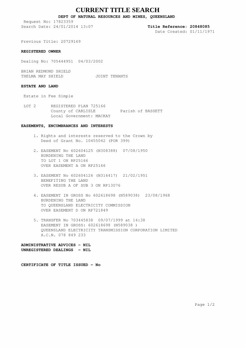
CURRENT TITLE SEARCH DEPT OF NATURAL RESOURCES AND MINES, QUEENSLAND Request No: 17823359Search Date: 24/01/2014 13:07 Title Reference: 20848085 Date Created: 01/11/1971 Previous Title: 20729169 REGISTERED OWNER Dealing No: 705444951 04/03/2002
BRIAN REDMOND SHIELDTHELMA MAY SHIELD JOINT TENANTS ESTATE AND LAND Estate in Fee Simple LOT 2 REGISTERED PLAN 725166 County of CARLISLE Parish of BASSETT Local Government: MACKAY EASEMENTS, ENCUMBRANCES AND INTERESTS 1. Rights and interests reserved to the Crown by Deed of Grant No. 10455042 (POR 399) 2. EASEMENT No 602604125 (N308388) 07/08/1950 BURDENING THE LAND TO LOT 1 ON RP25166 OVER EASEMENT A ON RP25166 3. EASEMENT No 602604126 (N316417) 21/02/1951 BENEFITING THE LAND OVER RESUB A OF SUB 3 ON RP13076 4. EASEMENT IN GROSS No 602618698 (N589038) 23/08/1968 BURDENING THE LAND TO QUEENSLAND ELECTRICITY COMMISSION OVER EASEMENT D ON RP721849 5. TRANSFER No 703445838 09/07/1999 at 14:38 EASEMENT IN GROSS: 602618698 (N589038 ) QUEENSLAND ELECTRICITY TRANSMISSION CORPORATION LIMITED A.C.N. 078 849 233 ADMINISTRATIVE ADVICES - NILUNREGISTERED DEALINGS - NIL CERTIFICATE OF TITLE ISSUED - No Page 1/2

CURRENT TITLE SEARCH DEPT OF NATURAL RESOURCES AND MINES, QUEENSLAND Request No: 17823359Search Date: 24/01/2014 13:07 Title Reference: 20848085 Date Created: 01/11/1971
Caution - Charges do not necessarily appear in order of priority
** End of Current Title Search **
COPYRIGHT THE STATE OF QUEENSLAND (DEPT OF NATURAL RESOURCES AND MINES) [2014]Requested By: D APPLICATIONS GLOBAL X Page 2/2
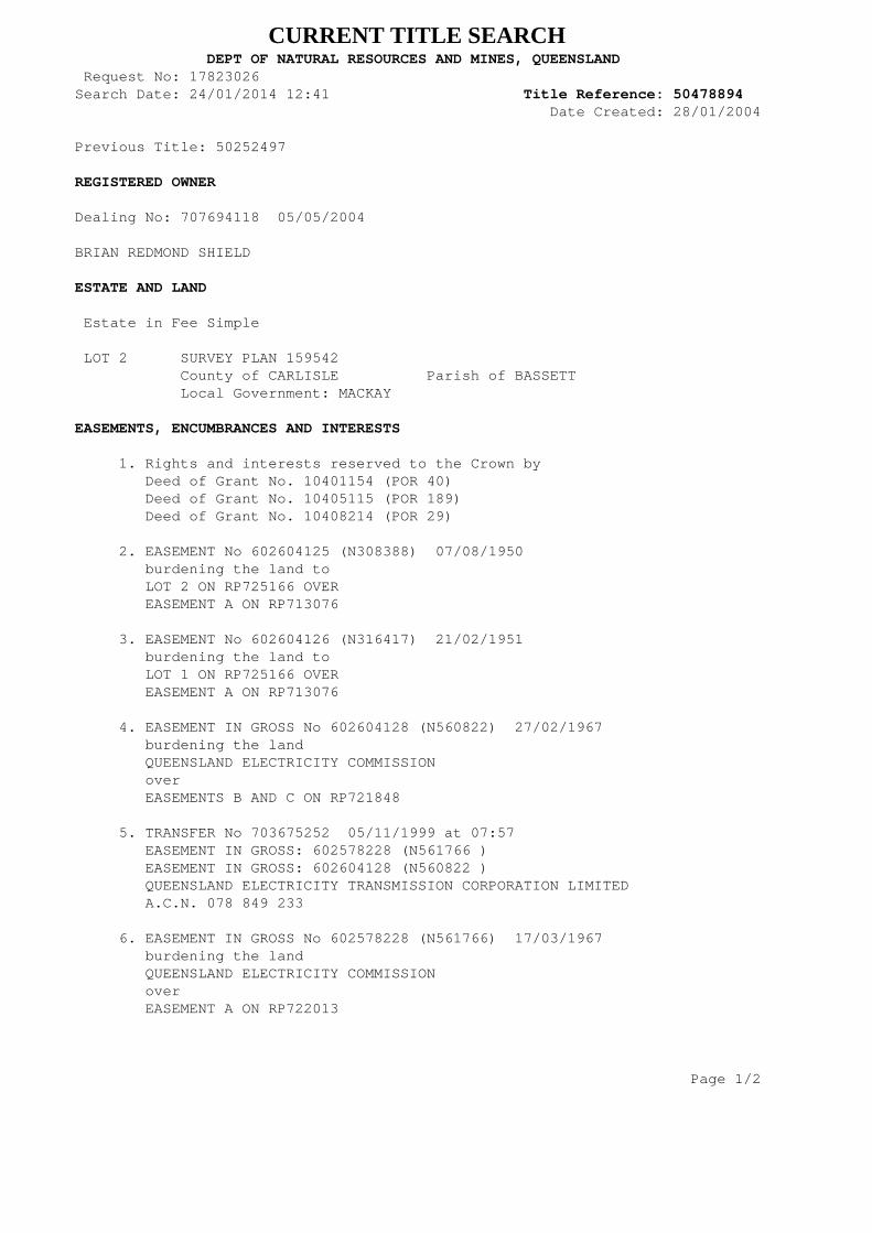
CURRENT TITLE SEARCH DEPT OF NATURAL RESOURCES AND MINES, QUEENSLAND Request No: 17823026Search Date: 24/01/2014 12:41 Title Reference: 50478894 Date Created: 28/01/2004 Previous Title: 50252497 REGISTERED OWNER Dealing No: 707694118 05/05/2004
BRIAN REDMOND SHIELD ESTATE AND LAND Estate in Fee Simple LOT 2 SURVEY PLAN 159542 County of CARLISLE Parish of BASSETT Local Government: MACKAY EASEMENTS, ENCUMBRANCES AND INTERESTS 1. Rights and interests reserved to the Crown by Deed of Grant No. 10401154 (POR 40) Deed of Grant No. 10405115 (POR 189) Deed of Grant No. 10408214 (POR 29) 2. EASEMENT No 602604125 (N308388) 07/08/1950 burdening the land to LOT 2 ON RP725166 OVER EASEMENT A ON RP713076 3. EASEMENT No 602604126 (N316417) 21/02/1951 burdening the land to LOT 1 ON RP725166 OVER EASEMENT A ON RP713076 4. EASEMENT IN GROSS No 602604128 (N560822) 27/02/1967 burdening the land QUEENSLAND ELECTRICITY COMMISSION over EASEMENTS B AND C ON RP721848 5. TRANSFER No 703675252 05/11/1999 at 07:57 EASEMENT IN GROSS: 602578228 (N561766 ) EASEMENT IN GROSS: 602604128 (N560822 ) QUEENSLAND ELECTRICITY TRANSMISSION CORPORATION LIMITED A.C.N. 078 849 233 6. EASEMENT IN GROSS No 602578228 (N561766) 17/03/1967 burdening the land QUEENSLAND ELECTRICITY COMMISSION over EASEMENT A ON RP722013 Page 1/2

CURRENT TITLE SEARCH DEPT OF NATURAL RESOURCES AND MINES, QUEENSLAND Request No: 17823026Search Date: 24/01/2014 12:41 Title Reference: 50478894 Date Created: 28/01/2004 ADMINISTRATIVE ADVICES - NILUNREGISTERED DEALINGS - NIL CERTIFICATE OF TITLE ISSUED - No
Caution - Charges do not necessarily appear in order of priority
** End of Current Title Search **
COPYRIGHT THE STATE OF QUEENSLAND (DEPT OF NATURAL RESOURCES AND MINES) [2014]Requested By: D APPLICATIONS GLOBAL X Page 2/2
3RP702720
FH
27.665ha
4
RP859411
C
RP
721860
24SP230182
FH
26.32haB
RP
721859
4RP910713
FH
16.3ha
3SP103879
FH
15.76ha
D
RP
721861
2RP702766
FH
31.861ha
3RP901926
FH
120.4ha1
RP8606472
RP860647
3
RP860647
4
RP
860647
5
RP860647
6
RP860647
11
RP
895313
7
RP
860647
A
RP722128A
RP722012
15
SP103875
13
SP103875
11SP178832
FH
27.79ha
20SP180183
FH
55.93ha
21
SP190258
18
SP199181
19
SP
199181
25
SP22092626
SP
220926
A
RP
722128
20SP241637
FH
20.22ha
22
SP
241637
11
CI3059
FH
40.901ha
10
SP159748
FH
19.3444ha
12
SP159748
10
SP159748
FH
19.3444ha
43
SP
130209
1
SP249705
2SP249705
FH
59.7854ha
1
RP719794
1RP702645
FH
21.206ha
2RP702789
FH
29.846ha
1
RP723378
10
RP722443
FH
9.801ha7
RP
722443
3RP702789
FH
24.59ha
4RP713076
FH
19.66ha
5SP167794FH15.9434ha
3
SP167794
1RP718845
FH7.332ha
15RP749096
FH
26.132ha
2
RP
708037
43
SP
130209
2RP904183
FH
65.9972ha
1
CI1061
1
RP72758410
RP
736929
1
RP723401FH
4.649ha
1
RP
722398
9
RP744485
FH
3.052ha
1
RP730314
1
RP713076
FH
9.776ha
2
RP730314
5
RP730314
4
RP730314
3
RP730314
6
RP730314
FH
6.549ha
1
RP723393
FH
5.562ha
2RP723393
FH
27.643ha2
RP708271
FH
20.588ha
2RP725166 FH
20.017ha
1RP725166
FH
41.771ha
1
RP
708255
2RP730774FH
29.047ha
1RP708271
FH
14.25ha
1
RP732997
FH
9.333ha
5RP702668
FH
72.161ha
2RP702798
FH
45.618ha
4
RP702752
1
RP730774
2.013ha
2
RP
7458023
RP745802
5
RP849126
2.096ha
2
RP847490
FH
8.172ha
11
RP
886925
2.826ha10
RP886925
9
RP
886925 8
RP
8869257
RP
886921
4
RP886921
3
RP886921
2
RP88692115
RP
886921
14
RP886921
13
RP886921
2.014ha
12
RP
886925
17
RP913519
2.005ha18
RP91351919
RP913519
1
RP
913519
12
RP913519
11
RP
913519
1.989ha
8RP730996
FH
0m²
14
RP913519
15
RP913519
16
RP913519
2.169ha
8
RP744485
FH
7.064ha
D
RP
722016
C
RP
722015
A
RP
722013
C
RP
721848
D
RP
721849
A
RP
721858
1
SP
109567
1
RL6707
7
SP103119
3.615ha 8SP103119
FH
15.73ha
B
RP
849126
25
SP143701
B
RP
721848
26
SP153668
27
SP153668
FH
5.573ha
1
SP
159542
2SP159542
FH
30.38ha
19
SP180183
1.829ha
20SP180183
FH
55.93ha
3
RP722821
FH
9.245ha
2
RP722821
A
RP
713076
A
RP
713076
A
RP
713076
24
SP230182
24
SP230182
26.32haB
RP721859
3
SP2237212
SP
223721
21
SP
233830
22
SP233830F
SP233830
2
SP
235050
1
SP
235050
21
SP247644 22
SP247644
B
SP247644
4RP866372
FH
23.92ha
1
RP
734293
7RP702751
FH
22.609ha
7SP125465
FH
41.5ha
6SP125465
FH
51.368ha
G
RP
910713
10SP232809
FH
50.24ha
RD
RS
CK
EVI
ROAD
JE N
SE
NS
RO
AD
RD
JEN
SE
NS
PAL
MR
IDG
ED
RIV
E
RO
AD
WA
INA
I
RO
AD
WA
INA
I
ROADROAD
HOLTS RD
HOLTS RD
GLE
ND
AR
AG
HR
OA
D
ADR
O
MIC
LERE-FAR
LEIGH
GARNER ST
RDHOLTS
KEE
RCSE
NAJ
ROAD
WADDELLS RD
ROAD
DCDB
Lot/Plan 2/SP159542
Area/Volume 30.38ha
Tenure FREEHOLD
Local Government MACKAY REGIONAL
Locality FARLEIGH
Parish BASSETT
County CARLISLE
Segment/Parcel 61820/134
SUBJECT PARCEL DESCRIPTION
SCALE 1 : 20000HORIZONTAL DATUM:GDA94 ZONE:55
m
400 800 1200 1600 20000
8755-44212
STANDARD MAP NUMBER
149°07'02".194
21°05'23".948
RICHMOND
1.61 KM
MAP WINDOW POSITION &NEAREST LOCATION
PRINTED (dd/mm/yyyy) 06/02/2014
DCDB 05/02/2014 (Lots with an area less than 3000m² are not shown)
Users of the information recorded in this document (the Information) accept all responsibility andrisk associated with the use of the Information and should seek independent professional advice inrelation to dealings with property.
Despite Department of Natural Resources and Mines(DNRM)'s best efforts, DNRM makesno representations or warranties in relation to the Information, and, to the extent permitted by law,exclude or limit all warranties relating to correctness, accuracy, reliability, completeness orcurrency and all liability for any direct, indirect and consequential costs, losses, damages andexpenses incurred in any way (including but not limited to that arising from negligence) inconnection with any use of or reliance on the Information
For further information on SmartMap products visit http://nrw.qld.gov.au/property/mapping/blinmap
CLIENT SERVICE STANDARDS
SmartMapAn External Product of
SmartMap Information Services
Based upon an extraction from the
Digital Cadastral Data Base
(c) The State of Queensland,(Department of NaturalResources and Mines) 2014.
7 19 000m E
19
7 20
7 20
21
21
1
76 65 000 m N65
2
6666
3
6767
4
6868
GDA
21°06'17".307
149°06'14".017 149°07'50".372
21°06'17".307
21°05'00"
21°04'30".590
149°07'50".372
21°04'30".590
149°06'14".017
21°05'00"
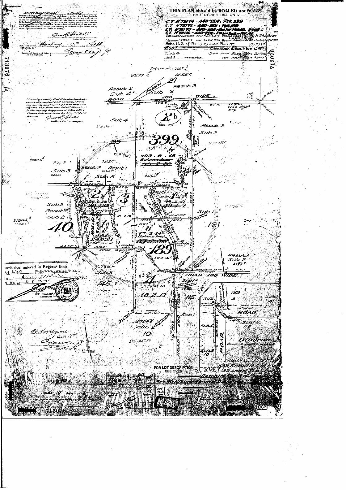
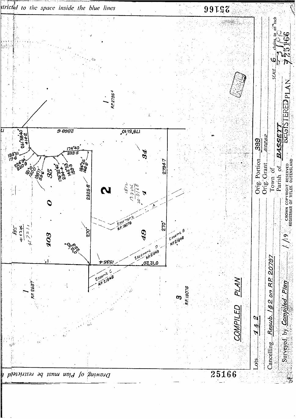

APPENDIX A – CURRENT TITLE SEARCH, SURVEY PLAN, SMART MAP & OWNERS CONSENT

APPENDIX B – PROPOSAL PLAN + SITE ANALYSIS PLAN
IDAS form 1—Application details (Sustainable Planning Act 2009 version 3.0 effective 1 July 2013)
This form must be used for ALL development applications.
You MUST complete ALL questions that are stated to be a mandatory requirement unless otherwise identified on this form.
For all development applications, you must:
• complete this form (IDAS form 1—Application details)
• complete any other forms relevant to your application
• provide any mandatory supporting information identified on the forms as being required to accompany your application.
Attach extra pages if there is insufficient space on this form.
All terms used on this form have the meaning given in the Sustainable Planning Act 2009 (SPA) or the Sustainable Planning Regulation 2009.
This form and any other IDAS form relevant to your application must be used for development applications relating to strategic port land and Brisbane core port land under the Transport Infrastructure Act 1994 and airport land under the Airport Assets (Restructuring and Disposal) Act 2008. Whenever a planning scheme is mentioned, take it to mean land use plan for the strategic port land, Brisbane core port land or airport land.
PLEASE NOTE: This form is not required to accompany requests for compliance assessment.
This form can also be completed online using MyDAS at www.dsdip.qld.gov.au/MyDAS
Mandatory requirements
Applicant details (Note: the applicant is the person responsible for making the application and need not be the owner of the land. The applicant is responsible for ensuring the information provided on all IDAS application forms is correct. Any development permit or preliminary approval that may be issued as a consequence of this application will be issued to the applicant.)
Name/s (individual or company name in full)
For companies, contact name
Postal address
Suburb
State Postcode
Country
Contact phone number
Mobile number (non-mandatory requirement)
Fax number (non-mandatory requirement)

IDAS form 1—Application details Version 3.0—1 July 2013
Email address (non-mandatory requirement)
@
Applicant’s reference number (non-mandatory requirement)
1. What is the nature of the development proposed and what type of approval is being sought?
Table A—Aspect 1 of the application (If there are additional aspects to the application please list in Table B—Aspect 2.)
a) What is the nature of the development? (Please only tick one box.)
Material change of use
Reconfiguring a lot Building work Operational work
b) What is the approval type? (Please only tick one box.)
Preliminary approval under s241 of SPA
Preliminary approval under s241 and s242 of SPA
Development permit
c) Provide a brief description of the proposal, including use definition and number of buildings or structures where applicable (e.g. six unit apartment building defined as a multi-unit dwelling, 30 lot residential subdivision etc.)
d) What is the level of assessment? (Please only tick one box.)
Impact assessment
Code assessment
Table B—Aspect 2 of the application (If there are additional aspects to the application please list in Table C—Additional aspects of the application.)
a) What is the nature of development? (Please only tick one box.)
Material change of use
Reconfiguring a lot Building work Operational work
b) What is the approval type? (Please only tick one box.)
Preliminary approval under s241 of SPA
Preliminary approval under s241 and s242 of SPA
Development permit
c) Provide a brief description of the proposal, including use definition and number of buildings or structures where applicable (e.g. six unit apartment building defined as a multi-unit dwelling, 30 lot residential subdivision etc.)
d) What is the level of assessment?
Impact assessment
Code assessment
Table C—Additional aspects of the application (If there are additional aspects to the application please list in a separate table on an extra page and attach to this form.)
Refer attached schedule
Not required

IDAS form 1—Application details Version 3.0—1 July 2013
2. Location of the premises (Complete Table D and/or Table E as applicable. Identify each lot in a separate row.)
Table D—Street address and lot on plan for the premises or street address and lot on plan for the land adjoining or adjacent to the premises (Note: this table is to be used for applications involving taking or interfering with water). (Attach a separate schedule if there is insufficient space in this table.)
Street address and lot on plan (All lots must be listed.)
Street address and lot on plan for the land adjoining or adjacent to the premises (Appropriate for development in water but adjoining or adjacent to land, e.g. jetty, pontoon. All lots must be listed.)
Street address Lot on plan description
Lot Unit no.
Street no.
Street name and official suburb/ locality name
Post-code
Lot no. Plan type and plan no.
Local government area (e.g. Logan, Cairns)
i)
ii)
iii)
Planning scheme details (If the premises involves multiple zones, clearly identify the relevant zone/s for each lot in a separate row in the below table. Non-mandatory)
Lot Applicable zone / precinct Applicable local plan / precinct Applicable overlay/s
i)
ii)
iii)
Table E—Premises coordinates (Appropriate for development in remote areas, over part of a lot or in water not adjoining or adjacent to land e.g. channel dredging in Moreton Bay.) (Attach a separate schedule if there is insufficient space in this table.)
Coordinates (Note: place each set of coordinates in a separate row)
Easting Northing Latitude Longitude
Zone reference
Datum Local government area (if applicable)
GDA94
WGS84
other
3. Total area of the premises on which the development is proposed (indicate square metres)
4. Current use/s of the premises (e.g. vacant land, house, apartment building, cane farm etc.)

IDAS form 1—Application details Version 3.0—1 July 2013
5. Are there any current approvals (e.g. a preliminary approval) associated with this application? (Non-mandatory requirement)
No Yes—provide details below
List of approval reference/s Date approved (dd/mm/yy) Date approval lapses (dd/mm/yy)
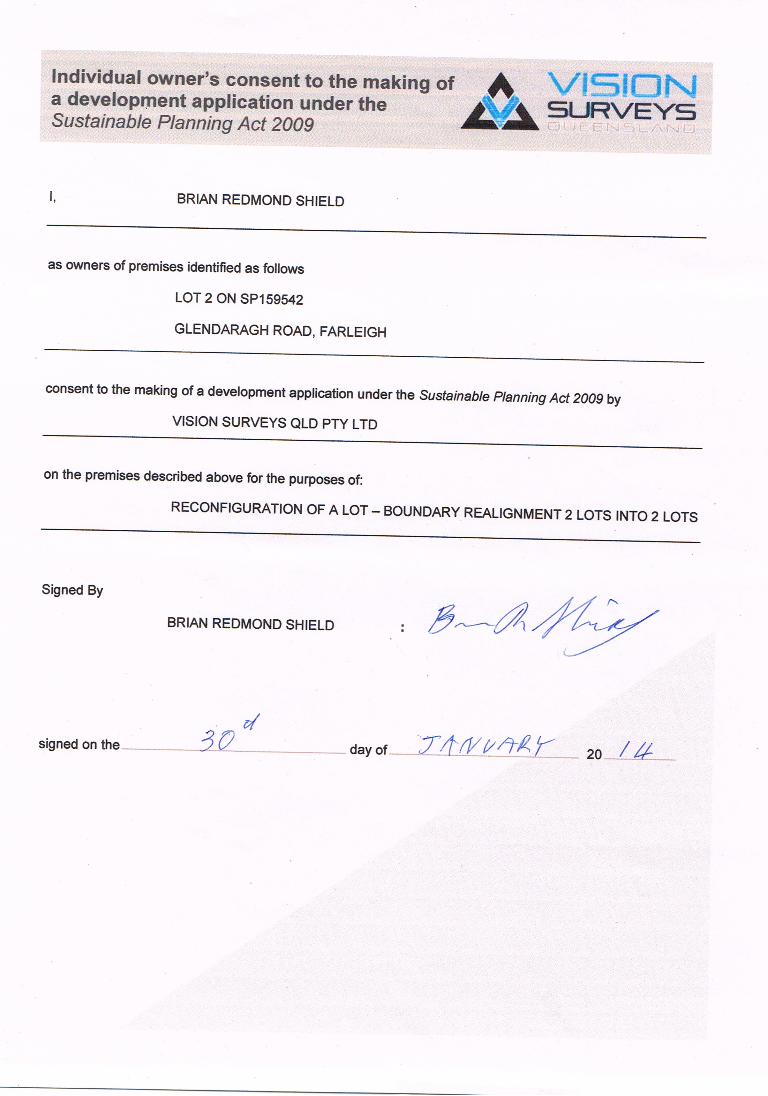
6. Is owner’s consent required for this application? (Refer to notes at the end of this form for more information.)
No
Yes—complete either Table F, Table G or Table H as applicable
Table F
Name of owner/s of the land
I/We, the above-mentioned owner/s of the land, consent to the making of this application.
Signature of owner/s of the land
Date
Table G
Name of owner/s of the land
The owner’s written consent is attached or will be provided separately to the assessment manager.
Table H
Name of owner/s of the land
By making this application, I, the applicant, declare that the owner has given written consent to the making of the application.
7. Identify if any of the following apply to the premises (Tick applicable box/es.)
Adjacent to a water body, watercourse or aquifer (e.g. creek, river, lake, canal)—complete Table I
On strategic port land under the Transport Infrastructure Act 1994—complete Table J
In a tidal water area—complete Table K
On Brisbane core port land under the Transport Infrastructure Act 1994 (No table requires completion.)
On airport land under the Airport Assets (Restructuring and Disposal) Act 2008 (no table requires completion)
Table I
Name of water body, watercourse or aquifer
Table J
Lot on plan description for strategic port land Port authority for the lot

IDAS form 1—Application details Version 3.0—1 July 2013
Table K
Name of local government for the tidal area (if applicable) Port authority for the tidal area (if applicable)
8. Are there any existing easements on the premises? (e.g. for vehicular access, electricity, overland flow, water etc)
No Yes—ensure the type, location and dimension of each easement is included in the plans submitted
9. Does the proposal include new building work or operational work on the premises? (Including any services)
No Yes—ensure the nature, location and dimension of proposed works are included in plans submitted
10. Is the payment of a portable long service leave levy applicable to this application? (Refer to notes at the end of this form for more information.)
No—go to question 12 Yes
11. Has the portable long service leave levy been paid? (Refer to notes at the end of this form for more information.)
No
Yes—complete Table L and submit with this application the yellow local government/private certifier’s copy of the receipted QLeave form
Table L
Amount paid Date paid
(dd/mm/yy)
QLeave project number (6 digit number starting with A, B, E, L or P)
12. Has the local government agreed to apply a superseded planning scheme to this application under section 96 of the Sustainable Planning Act 2009?
No
Yes—please provide details below
Name of local government Date of written notice given by local government (dd/mm/yy)
Reference number of written notice given by local government (if applicable)
IDAS form 1—Application details Version 3.0—1 July 2013
13. List below all of the forms and supporting information that accompany this application (Include all IDAS forms, checklists, mandatory supporting information etc. that will be submitted as part of this application. Note: this question does not apply for applications made online using MyDAS)
Description of attachment or title of attachment Method of lodgement to assessment manager
14. Applicant’s declaration
By making this application, I declare that all information in this application is true and correct (Note: it is unlawful to provide false or misleading information)
Notes for completing this form • Section 261 of the Sustainable Planning Act 2009 prescribes when an application is a properly-made application.
Note, the assessment manager has discretion to accept an application as properly made despite any non-compliance with the requirement to provide mandatory supporting information under section 260(1)(c) of the Sustainable Planning Act 2009
Applicant details
• Where the applicant is not a natural person, ensure the applicant entity is a real legal entity. Question 1
• Schedule 3 of the Sustainable Planning Regulation 2009 identifies assessable development and the type of assessment. Where schedule 3 identifies assessable development as “various aspects of development” the applicant must identify each aspect of the development on Tables A, B and C respectively and as required.
Question 6
• Section 263 of the Sustainable Planning Act 2009 sets out when the consent of the owner of the land is required for an application. Section 260(1)(e) of the Sustainable Planning Act 2009 provides that if the owner’s consent is required under section 263, then an application must contain, or be accompanied by, the written consent of the owner, or include a declaration by the applicant that the owner has given written consent to the making of the application. If a development application relates to a state resource, the application is not required to be supported by evidence of an allocation or entitlement to a state resource. However, where the state is the owner of the subject land, the written consent of the state, as landowner, may be required. Allocation or entitlement to the state resource is a separate process and will need to be obtained before development commences.
Question 11
• The Building and Construction Industry (Portable Long Service Leave) Act 1991 prescribes when the portable long service leave levy is payable.
• The portable long service leave levy amount and other prescribed percentages and rates for calculating the levy are prescribed in the Building and Construction Industry (Portable Long Service Leave) Regulation 2002.

IDAS form 1—Application details Version 3.0—1 July 2013
Department of State Development, Infrastructure and Planning PO Box 15009 City East Qld 4002 tel 13 QGOV (13 74 68) [email protected] www.dsdip.qld.gov.au
Question 12
• The portable long service leave levy need not be paid when the application is made, but the Building and Construction Industry (Portable Long Service Leave) Act 1991 requires the levy to be paid before a development permit is issued.
• Building and construction industry notification and payment forms are available from any Queensland post office or agency, on request from QLeave, or can be completed on the QLeave website at www.qleave.qld.gov.au. For further information contact QLeave on 1800 803 481 or visit www.qleave.qld.gov.au.
Privacy—The information collected in this form will be used by the Department of State Development, Infrastructure and Planning (DSDIP), assessment manager, referral agency and/or building certifier in accordance with the processing and assessment of your application. Your personal details should not be disclosed for a purpose outside of the IDAS process or the provisions about public access to planning and development information in the Sustainable Planning Act 2009, except where required by legislation (including the Right to Information Act 2009) or as required by Parliament. This information may be stored in relevant databases. The information collected will be retained as required by the Public Records Act 2002.
OFFICE USE ONLY
Date received Reference numbers
NOTIFICATION OF ENGAGEMENT OF A PRIVATE CERTIFIER
To Council. I have been engaged as the private certifier for the building work referred to in this application
Date of engagement Name BSA Certification license number
Building classification/s
QLEAVE NOTIFICATION AND PAYMENT (For completion by assessment manager or private certifier if applicable.)
Description of the work QLeave project number
Amount paid ($)
Date paid
Date receipted form sighted by assessment manager
Name of officer who sighted the form
The Sustainable Planning Act 2009 is administered by the Department of State Development, Infrastructure and Planning. This form and all other required application materials should be sent to your assessment manager and any referral agency.

IDAS form 7—Reconfiguring a lot (Sustainable Planning Act 2009 version 3.0 effective 1 July 2013)
This form must be used for development applications or requests for compliance assessment for reconfiguring a lot.
You MUST complete ALL questions that are stated to be a mandatory requirement unless otherwise identified on this form.
For all development applications, you must:
• complete IDAS form 1—Application details
• complete any other forms relevant to your application
• provide any mandatory supporting information identified on the forms as being required to accompany your application.
For requests for compliance assessment, you must:
• complete IDAS form 32—Compliance assessment
• Provide any mandatory supporting information identified on the forms as being required to accompany your request
Attach extra pages if there is insufficient space on this form.
All terms used on this form have the meaning given in the Sustainable Planning Act 2009 (SPA) or the Sustainable Planning Regulation 2009.
This form can also be completed online using MyDAS at www.dsdip.qld.gov.au/MyDAS
Mandatory requirements
1. What is the total number of existing lots making up the premises?
2. What is the nature of the lot reconfiguration? (Tick all applicable boxes.)
subdivision—complete questions 3–6 and 11
boundary realignment—complete questions 8, 9 and 11
creating an easement giving access to a lot from a constructed road—complete questions 10 and 11
dividing land into parts by agreement—please provide details below and complete questions 7 and 11
3. Within the subdivision, what is the number of additional lots being created and their intended final use?
Intended final use of new lots Residential Commercial Industrial Other—specify
Number of additional lots created
4. What type of approval is being sought for the subdivision?
Development permit
Preliminary approval
Compliance permit

IDAS form 7—Reconfiguring a lot Version 3.0—1 July 2013
5. Are there any current approvals associated with this subdivision application or request? (E.g. material change of use.)
No Yes—provide details below
List of approval reference/s Date approved (dd/mm/yy) Date approval lapses (dd/mm/yy)
6. Does the proposal involve multiple stages?
No—complete Table A Yes—complete Table B
Table A
a) What is the total length of any new road to be constructed? (metres)
b) What is the total area of land to be contributed for community purposes? (square metres)
c) Does the proposal involve the construction of a canal or artificial waterway?
No Yes
d) Does the proposal involve operational work for the building of a retaining wall?
No Yes
Table B—complete a new Table B for every stage if the application involves more than one stage
a) What is the proposed estate name? (if known and if applicable)
b) What stage in the development does this table refer to?
c) If a development permit is being sought for this stage, will the development permit result in additional residential lots?
No Yes—specify the total number
d) What is the total area of land for this stage? (square metres)
e) What is the total length of any new road to be constructed at this stage? (metres)
f) What is the total area of land to be contributed for community purposes at this stage? (square metres)
g) Does the proposal involve the construction of a canal or artificial waterway?
No Yes
h) Does the proposal involve operational work for the building of a retaining wall?
No Yes
7. Lease/agreement details—how many parts are being created and what is their intended final use?
Intended final use of new parts Residential Commercial Industrial Other—specify
Number of additional parts created

IDAS form 7—Reconfiguring a lot Version 3.0—1 July 2013
8. What are the current and proposed dimensions following the boundary realignment for each lot forming the premises?
Current lot Proposed lot
Lot plan description Area (square metres)
Length of road frontage Lot number Area (square metres)
Length of road frontage
9. What is the reason for the boundary realignment?
10. What are the dimensions and nature of the proposed easement? (If there are more than two easements proposed please list in a separate table on an extra page and attach to this form.)
Width (m) Length (m) Purpose of the easement (e.g. pedestrian access)?
What land is benefitted by the easement?
Mandatory supporting information
11. Confirm that the following mandatory supporting information accompanies this application or request
Mandatory supporting information Confirmation of lodgement
Method of lodgement
All applications and requests for reconfiguring a lot
Site plans drawn to an appropriate scale (1:100, 1:200 or 1:500 are the recommended scales) which show the following:
• the location and site area of the land to which the application or request relates (relevant land)
• the north point
• the boundaries of the relevant land
• any road frontages of the relevant land, including the name of the road
• the contours and natural ground levels of the relevant land
• the location of any existing buildings or structures on the relevant land
• the allotment layout showing existing lots, any proposed lots (including the dimensions of those lots), existing or proposed road reserves, building envelopes and existing or proposed open space (note: numbering is required for all lots)
• any drainage features over the relevant land, including any watercourse, creek, dam, waterhole or spring and any land subject to a flood with an annual exceedance probability of 1%
• any existing or proposed easements on the relevant land and their function
• all existing and proposed roads and access points on the relevant land
• any existing or proposed car parking areas on the relevant land
• the location of any proposed retaining walls on the relevant land and their height
• the location of any stormwater detention on the relevant land
• the location and dimension of any land dedicated for community
Confirmed

IDAS form 7—Reconfiguring a lot Version 3.0—1 July 2013
Department of State Development, Infrastructure and Planning PO Box 15009 City East Qld 4002 tel 13 QGOV (13 74 68) [email protected] www.dsdip.qld.gov.au
purposes
• the final intended use of any new lots.
For a development application – A statement about how the proposed development addresses the local government’s planning scheme and any other planning documents relevant to the application.
For a request for compliance assessment – A statement about how the proposed development addresses the matters or things against which the request must be assessed.
Confirmed
A statement addressing the relevant part(s) of the State Development Assessment Provisions (SDAP).
Confirmed
Not applicable
For an application involving assessable development in a wild river area
Documentation that:
• describes how the development to which the application relates is not prohibited development and
• demonstrates how the proposed development will meet the requirements set out in the relevant wild river declaration and any applicable code mentioned in the relevant wild river declaration under the Wild Rivers Act 2005.
Confirmed
Not applicable
A map showing the proposed location of the development in relation to any nominated waterways under the Wild Rivers Act 2005 and wild river management areas. (a map may be produced digitally at www.ehp.qld.gov.au/wildrivers/wildrivers-map.php).
Wild river management area means any of the following areas under the Wild Rivers Act 2005:
• special floodplain management area • preservation area • high preservation area • floodplain management area • subartesian management area • designated urban area.
Editor's note: A floodplain management area, subartesian management area or designated urban area may be over all or part of a high preservation area or preservation area. A subartesian management area or designated urban area may be over all or part of a special floodplain management area.
Confirmed
Not applicable
Notes for completing this form
•••• For supporting information requirements for requests for compliance assessment, please refer to the relevant matters for which compliance assessment will be carried out against. To avoid an action notice, it is recommended that you provide as much of the mandatory information listed in this form as possible.
Privacy—Please refer to your assessment manager, referral agency and/or building certifier for further details on the use of information recorded in this form.
OFFICE USE ONLY
Date received Reference numbers
The Sustainable Planning Act 2009 is administered by the Department of State Development, Infrastructure and Planning. This form and all other required application materials should be sent to your assessment manager and any referral agency.

APPENDIX C – IDAS FORMS

APPENDIX D
RURAL ZONE CODE [FRAME LOCALITY]
MACKAY CITY PLANNING SCHEME 2006

Rural Zone Code Glendaragh Road, FARLEIGH
Mackay City Planning Scheme 20096 ` 14016 – Shield
Specific Outcomes Acceptable / Probable Solutions Responses
Assessable Development
P1 The use of land within the Rural Zone for rural purposes is sustainable over the long term by:
(i) avoiding fragmentation of agricultural lots; and
(ii) using the land according to industry best practice, including:
(a) risk reduction for natural hazards such as bushfire, flooding, land slips and soil erosion;
(b) the management of weeds and pests;
(c) waste reduction and management;
(d) ensuring the intensity of use is in keeping with the
capacity of the land.
S1 No solution specified. Complies
The uses on both proposed lots are not being altered.
Fragmentation is not occurring
Realignment is for land management purposes in accordance with the information outlined in the Town Planning Report.
The intensity of uses will remain the same and continue to be in keeping with the capacity of the land
P2 The major infrastructure supporting the sugar industry mills and associated network of tramways and haul-out roads is protected from the effects of encroaching sensitive land uses.
S2 No solution specified. Not Applicable
P3 Any expansion of either the Pleystowe and Racecourse mills is designed to mitigate any adverse impacts on surrounding land.
S3 No solution specified. Not Applicable
No expansions of the Pleystowe and Racecourse mills are proposed.
P4 Intense forms of rural activity requiring upgrade of the existing service infrastructure, are located within reasonable proximity to the urban area of Mackay and the Port of Mackay, providing that the environmental impacts can be managed and the particular nature of the activity does not require a more remote location.
S4 No solution specified. Not Applicable

Rural Zone Code Glendaragh Road, FARLEIGH
Mackay City Planning Scheme 20096 ` 14016 – Shield
P5 Non-rural activities do not occur on land included in the Rural Zone. S5 No solution specified. Not Applicable
Each proposed Lot will remain as land in the rural zone in which no uses will occur.
P6 Rural residential development does not occur. S6 No solution specified. Complies
The proposal will not include any rural-residential development.

APPENDIX E
ENVIRONMENT AND INFRASTRUCTURE CODE
MACKAY CITY PLANNING SCHEME 2006

Environment and Infrastructure Code Glendaragh Road, FARLEIGH
Mackay City Planning Scheme 2006 14016 – Shield
Compliance column key:
Achieved A/S Alternative solution N/A Not applicable
Specific Outcomes Acceptable / Probable Solutions Compliance Response
INFRASTRUCTURE PROVISIONS
P1 Adequate infrastructure is provided in time
to meet the needs of the development.
S1 The timing for provision of infrastructure for
development complies with the standards and contribution
requirements detailed in the Engineering Design Guidelines
Planning Scheme Policy
N/A Not Applicable
P2 Premises are provided with appropriate
areas of private and public open space.
Note: Guidance in regards to the design and
provision of open space is provided in the Open
Space Planning Scheme Policy and the Contributions
Planning Scheme Policy.
S2 The provision of open space complies with the
standards and requirements detailed in the Open Space
Planning Scheme Policy and the Contributions Planning
Scheme Policy.
N/A Not Applicable
No open space is associated with this application.
P3 Premises have
(i) an adequate, safe and reliable supply of
water, including potable water, and is connected,
where possible, to an existing reticulated water
supply.
(ii) the planning and design of potable water
infrastructure considers Water Sensitive Urban
Design (WSUD) such as water conservation
initiatives.
S3.1 Premises are connected to Council’s reticulated water
supply system.
S3.2 If connection to Council’s reticulated water supply
system is not possible, a potable water supply is provided in
accordance with the standards detailed in the Engineering
Design guidelines Planning Scheme Policy).
N/A Not Applicable
Both allotments do not retain any Council infrastructure in regards to
water networks.

Environment and Infrastructure Code Glendaragh Road, FARLEIGH
Mackay City Planning Scheme 2006 14016 – Shield
P4 Treatment and disposal of waste water
ensures:
(i) no adverse ecological impacts on the
environment, particularly nearby receiving
environments including surface waters and ground
water; and
(ii) the cumulative impacts of on site waste
water treatment will not cause deterioration of
environmental conditions;
(iii) the planning and design of wastewater
infrastructure considers Water Sensitive Urban
Design (WSUD) such as wastewater management
measures.
S4.1 Connection to Council’s reticulated sewerage
treatment system; or
S4.2 Where connection to Council reticulated sewerage
system is not possible, and where 20 people or less, Council
will refer to the requirements of the Environmental
Protection (Water) Policy 1997 and the On Site Sewerage
Code (NR&M July 2002) and AS 1547. to ensure the
premises are suitable for effluent disposal.
S4.3 Where more than 20 people, no solution specified.
N/A Not Applicable
Both allotments do not retain any Council infrastructure in regards to
sewerage systems.
Stormwater Management
P5 Drainage works are planned for and
designed to ensure that adjoining land and the
existing upstream and downstream drainage systems
are not adversely affected by development, taking
into account:
(i) Water Sensitive Urban Design (WSUD)
principles such as:
- protect natural systems;
- enhance natural waterway systems within
- detention of stormwater instead of rapid
conveyance;
- minimise impervious areas;
- utilisation of stormwater to conserve
potable water;
- integrate stormwater treatment into the
landscape;
S5 Drainage works complies with the requirements of
the Engineering Design Guidelines Planning Scheme Policy
N/A Not Applicable
There is no drainage works proposed.

Environment and Infrastructure Code Glendaragh Road, FARLEIGH
Mackay City Planning Scheme 2006 14016 – Shield
- water efficient landscaping; and
- protection of water related environmental
values.
(ii) need for a stormwater system that can be
economically maintained;
(iii) safety of pedestrians and vehicles;
(iv) location of discharge;
(v) construction of buildings, structures or
paving up to site boundaries which avoid blocking
or concentrating natural flow paths .
(vi) fauna movement is provided for through
bridges and culverts
External Works
P6 Kerb and channelling is provided to a
satisfactory standard and constructed to:
(i) prevent edge fretting;
(ii) perform required drainage functions;
(iii) provide the appropriate level of control for
vehicle movement;
(iv) allow ready access to abutting properties at
suitable locations; and
(v) contribute to the desired streetscape
character of the locality.
S6 Premises are provided with kerb and channel in
accordance with the Engineering Design Guidelines
Planning Scheme Policy.
N/A Not Applicable
Not applicable to the application
Roads
P7 All proposed road pavement surfaces:
(i) are of a quality and durability suitable to
the intended traffic volumes and loads;
(ii) provide all-weather access;
(iii) allow the discharge of rainfall;
(iv) provide the safe passage of vehicles and
pedestrians; and
S7 Roads are provided in accordance with the
Engineering Design Guidelines Planning Scheme Policy ‘.
N/A Not Applicable
The application does not propose any new roads.

Environment and Infrastructure Code Glendaragh Road, FARLEIGH
Mackay City Planning Scheme 2006 14016 – Shield
(v) provide a reasonable, comfortable riding
quality.
Drainage Network
P8 In urban areas, the major drainage network
is designed and constructed with the capacity to
control stormwater flows under normal and minor
system blockage conditions for the DFE applicable to
drainage so that:
(i) floodways are restricted to areas where
there is no damage to property or hazards for
motorists, and
(ii) runoff is directed to a lawful point of
discharge through competently designed and
constructed outlet works.
S8 Design requirements of the Engineering Design
Guidelines Planning Scheme Policy.
N/A Not Applicable
The application does not propose a drainage network.
Public Utilities
P9 Street lighting and signs are provided to
ensure the safety of both vehicles and pedestrians,
and to facilitate access and movement.
S9 Street lighting and signage comply with the
requirements of the Engineering Design Guidelines Planning
Scheme Policy.
N/A Not Applicable
Not applicable to the application.
Infrastructure Payments
P10 The costs of providing infrastructure is
funded by the development giving rise to the need for
the infrastructure.
S10 The funding of infrastructure complies with the
requirements of the Contributions Planning Scheme Policy.
N/A Not Applicable
Not applicable to the application.
Car Parking and Access
P11 Premises are provided with:
(i) adequate vehicle parking spaces to satisfy
the anticipated requirements of the activity;
(ii) safe and efficient access and manoeuvring
areas to meet the anticipated volume and type of
S11.1 Vehicle parking on the site is in accordance with the
rates specified in Schedule 2.
S11.2 Vehicles are able to enter and exit the site (with the
exception of dwelling house and duplex) in a forward gear.
N/A Not Applicable.
The proposal does not consider any vehicle parking as there are no
changes to the existing uses of each property. Therefore vehicle
parking is not applicable.

Environment and Infrastructure Code Glendaragh Road, FARLEIGH
Mackay City Planning Scheme 2006 14016 – Shield
traffic;
(iii) large vehicles are able to enter and leave
the site without prejudicing the safety and efficiency
of the road;
(iv) access driveways are located and
designed to minimise conflicts with traffic and
pedestrians; and
(v) vehicle crossings from the carriageway to
the frontage of the site are constructed and finished
to appropriate standards for the expected volume and
type of traffic generated by activities on the site.
S11.3 The design of car parking and access complies with
the requirements detailed in the Engineering Design
Guidelines Planning Scheme Policy.
Access will remain in its current extent.
ENVIRONMENTAL ACTIVITY
Lighting Management
P1 Outdoor lighting does not cause a loss of
amenity to adjacent premises or adversely impact on
native fauna as a result of the light it emits either
directly or by reflection.
Note: Council will refer to the provisions of AS4282 –
Control of the Obtrusive Effects of Outdoor Lighting
S1 No solution specified. Complies
The subject site will not cause loss of amenity as a result from outdoor
lighting.
Overshadowing
P2 The amenity of adjacent residential land is
not adversely affected by shadows cast by adjoining
building or structures.
S2 Buildings do not cast a shadow over more than
30% of an adjoining residential lot at any time
between the hours of 9am and 3pm on 22 June.
N/A Not Applicable.
No new buildings are proposed.
Building Setbacks
P3 Residential buildings are sited to minimise
loss of amenity for residents’ adjacent to cane tram
lines.
S3 Residential buildings are set back a minimum of:
(i) 50m from cane tram lines; and
(ii) 100m from cane tram line level crossings and
sidings.
N/A Not Applicable.

Environment and Infrastructure Code Glendaragh Road, FARLEIGH
Mackay City Planning Scheme 2006 14016 – Shield
NOISE AND VIBRATION MANAGEMENT
P1 Noise and vibration do not detract from the
amenity of residents or employees of any adjacent
premises.
S1 No solution specified. N/A Not Applicable
Not applicable to the application.
P2 Premises accommodating uses which are
likely to generate noise are designed and constructed
with noise attenuation measures to avoid noise
nuisance to nearby uses.
S2 No solution specified. N/A Not Applicable
Not applicable to the application.
P3 Noise sensitive uses locating adjacent to
State controlled transport infrastructure incorporate
attenuation, building design and orientation
measures.
Note: Development adjacent to State controlled
roads complies with the Department of Main Roads –
Road Traffic Noise Management Code of Practice.
S3 No solution specified. N/A Not Applicable
Not applicable to the application.
AIR QUALITY
P1 Premises used for purposes likely to
generate emissions such as air pollutants, heat and
odours incorporate:
(i) physical measures for removing pollutants
from emissions prior to discharge to the atmosphere;
(ii) physical measures for reducing the
temperature gradient between emissions and the
atmosphere prior to discharge; and
(iii) operational systems, including monitoring
systems for major industry and major infrastructure,
which maintain emissions within ANZECC guideline
standards.
S1 No solution specified. N/A Not Applicable
Not applicable to the application.

Environment and Infrastructure Code Glendaragh Road, FARLEIGH
Mackay City Planning Scheme 2006 14016 – Shield
FLOODING
P1 Premises subject to risk of inundation or
damage through flood are provided with immunity to
that risk in order to reduce potential property damage
and to ensure public safety.
S1.1 Development is sited on land that would not be
subject to flooding during a DFE; or
S1.2 For development comprising a residential element,
the floors of all habitable rooms are located 300mm above
the DFE; or
S1.3 For non residential development or development
involving temporary or moveable residential structures (e.g.
caravan parks):
(i) buildings are located and designed so that floor
levels (except areas used for car parking) are 300mm above
the DFE; or
(ii) there is at least one evacuation route that remains
passable for emergency evacuations during all floods up to
and including the DFE.
N/A Not Applicable
Not applicable to the application.
P2 There is no increase in the number of
people living or working on a flood prone site, except
where the premises are occupied on a short term or
intermittent basis.
S2 No solution specified. N/A Not Applicable
Not applicable to the application.
P3 Development does not result in adverse
impacts for the safety of people or the capacity to use
land within a floodplain and does not involve:
(i) Any physical alteration to a watercourse; or
(ii) Net filling of 50 cubic metres; or
(iii) The proposed works either:
(A) avoid any reductions of on-site flood
storage capacity and contain within the subject site
S3 No solution specified. N/A Not Applicable
Not applicable to the application.

Environment and Infrastructure Code Glendaragh Road, FARLEIGH
Mackay City Planning Scheme 2006 14016 – Shield
any changes in depth / duration / velocity in flood
waters of all floods up to and including the DFE; or
(B) do not change the flood characteristics at
the DFE outside the subject site in ways that result in:
- loss of flood storage;
- loss of / changes to flow paths;
- acceleration or retardation of flows; or
- any reduction of flood warning times
elsewhere on the floodplain.
P4 Storage and handling of hazardous
substances on sites that are subject to risk of
inundation or damage through flood, ensures that
persons and property are not placed at unreasonable
risk.
S4 Storage or handling of substances that may be a
hazard to the environment or human safety by the risk of
contamination due to flooding:
(i) is undertaken in accordance with a risk
assessment; and
(ii) provides for the storage of any hazardous
substances above or securely isolated from the DFE level.
N/A Not Applicable
Not applicable to the application.
P5 The use is designed to minimise the impact
of Cyclonic Hazards
S5 No solution specified. N/A Not Applicable
Not applicable to the application.
Undefined Flood and Inundation Areas
P6 Where flood limits are not identified,
development is undertaken such that there is no
adverse effects on flood levels or flows on the site or
up-stream and down-stream of the site
S6 No solution specified. N/A Not Applicable
Not applicable to the application.

Environment and Infrastructure Code Glendaragh Road, FARLEIGH
Mackay City Planning Scheme 2006 14016 – Shield
WATER QUALITY
P1 Development does not detract from the
maintenance of water quality in the City’s
watercourses and bulk water storages, in particular
its:
(i) environmental values; and
(ii) where applicable, potability of the water
supply.
S1 No solution specified. N/A Not Applicable
Not applicable to the application.
P2 Premises incorporate:
(i) physical measures for intercepting and
treating surface water drainage and spilled
substances prior to their release to the watercourses;
and
(ii) bunding of sites or areas within sites or
integrated drainage systems which include waste
water treatment measures, where chemicals, fuels,
lubricants or other soluble pollutants are being
handled or stored.
Note: Council will refer to the Environmental
Protection Policy (Water) 1997
S2 No solution specified. N/A Not Applicable
Not applicable to the application.
P3 The City’s groundwater resources and
surface waters are maintained by:
(i) providing a stormwater system that
manages stormwater quantity and quality prior to
discharging into receiving waters;
(ii) providing non-structural source control
measures;
S3 No solution specified. N/A Not Applicable
Not applicable to the application.

Environment and Infrastructure Code Glendaragh Road, FARLEIGH
Mackay City Planning Scheme 2006 14016 – Shield
(iii) providing structural source control
measures;
(iv) retaining or rehabilitating natural waterway
corridors such as natural channels, wetlands
and riparian vegetation
(v) providing storage of waste water in secure
and sealed storage facilities;
(vi) ensuring efficient disposal areas and
ground and surface water retrieval areas are buffered
from each other;
(vii) ensuring that contaminants do not enter
the groundwater resources; and
(viii) with reuse of reclaimed water, ensuring
safe treatment and disposal of contaminated water.
P4 The biodiversity and habitat values of
coastal areas and associated estuarine systems are
protected from:
(i) increased nutrient or sediment levels; or
(ii) changed flow, inhibited passage, or
hydrologic regimes of the natural coastal and marine
margins, which may result from development.
S4 No solution specified. N/A Not Applicable
Not applicable to the application.
P5 Sediment and nutrient loadings into a
watercourse are minimised through:
(i) treated on-site effluent;
(ii) adequate stormwater run-off controls; and
S5 No solution specified. N/A Not Applicable
The proposal will not alter the use of the both existing allotments. The
application seeks to realign a small area of the property boundary
between proposed lot 21 and 22.

Environment and Infrastructure Code Glendaragh Road, FARLEIGH
Mackay City Planning Scheme 2006 14016 – Shield
(iii) on-site and off site erosion and sediment
controls.
EROSION AND SEDIMENT CONTROL
P1 Minimisation of the risk of erosion and
sedimentation either on-site or elsewhere, by a
comprehensive approach to soil erosion control and
sedimentation management, including:
(i) the minimisation of:
(ii) (ii) earthworks;
(a) clearing of land;
(b) long term stockpiling of excavated
materials;
(iii) use of appropriate construction
management techniques;
(iv) diverting surface water drainage around
disturbed areas; and
(v) treating and removing sediments from
stormwater over disturbed areas prior to release from
the site.
S1 The control of Erosion and Sedimentation
complies with Planning Scheme Policy 15.07 - Engineering
Design Guideline D7 Soil and Water Quality Management.
N/A Not Applicable
Not applicable to the application.
P2 Progressive rehabilitation of disturbed
areas occurs within the site through a comprehensive
rehabilitation program including:
(i) the grading and reshaping of the disturbed
areas to provide controlled and stable drainage flow
paths;
(ii) the construction of drainage paths which
S2 No solution specified. N/A Not Applicable
Not applicable to the application.

Environment and Infrastructure Code Glendaragh Road, FARLEIGH
Mackay City Planning Scheme 2006 14016 – Shield
divert high velocity flows away from disturbed areas;
(iii) the re-spreading of stored top soil stripped
from the site; and
(iv) the planting of the disturbed area with
native species of grasses, ground covers and trees.
COASTAL MANAGEMENT
Public Access and Roads
P1
(i) there is no net loss of public access to the
foreshore, or of public useability of coastal waters;
(ii) appropriate location and design is achieved
with respect to sensitive coastal resources and their
values;
(iii) roads that run parallel to the coast, are set
back from erosion prone areas and significant coastal
resources, with only smaller access roads running to
the coast; and
(iv) minor spur roads to the foreshore and
associated car parks provide access to the foreshore
at locations that are convenient to the public, have
low environmental sensitivity, and avoid locations that
may increase storm tide hazard.
S1 No solution specified. N/A Not Applicable
Not applicable to the application.
Erosion Prone Areas
P1 Development and permanent buildings are
minimised in erosion-prone areas as defined in this
code (apart from temporary or relocatable structures
required for safety and recreational purposes).
S1.1 Reconfiguring a lot within an erosion prone area
incorporates erosion prone land as undeveloped open
space.
S1.2 Relocatable structures such as picnic tables,
N/A Not Applicable
Not applicable to the application.
Environment and Infrastructure Code Glendaragh Road, FARLEIGH
Mackay City Planning Scheme 2006 14016 – Shield
barbecues, coastal trails, bikeways, demountable structures,
equipment sheds, lookouts, elevated decks, shelter sheds
etc are located within erosion prone areas only where they
remain relocatable.
S1.3 All other development is;
(i) located outside of the erosion prone area;
Or
(ii) as far landward as practical within the lot ;
And
(iii) is coastal dependent development (as
defined in this code).
S1.4 All building works (excluding demolition), including
extension to existing buildings, on lots wholly or partly within
the erosion prone area are:
(i) For rural areas and undeveloped urban areas,
located landward of the erosion prone area to minimise the
extent of permanent building inside the erosion prone area;
and
(i) (ii) For urban areas, located wholly
landward of the alignment of existing
neighbouring buildings and of a scale and
intensity similar to that of the surrounding
development.
P2 Where there is existing development within
an erosion-prone area, redevelopment and
extensions do not (as defined in this code):-
P2 No solution specified. N/A Not Applicable
Not applicable to the application.

Environment and Infrastructure Code Glendaragh Road, FARLEIGH
Mackay City Planning Scheme 2006 14016 – Shield
(i) extend the intensity of the existing level; or
(ii) compromise coastal management
outcomes and principles
Note: Supporting information required in order to
demonstrate compliance is set out in the Erosion
Prone Area Planning Scheme Policy.
COASTAL MANAGEMENT
P1 Development is provided with adequate
and suitable landscaping and screening on the site
which ensures:
(i) an attractive streetscape appearance; and
(ii) the privacy and amenity of any adjoining
residences.
S1 Landscaping is provided in accordance with the
Landscaping Planning Scheme Policy
N/A Not Applicable
Not applicable to the application.
P2 Landscaping is designed to prevent
encroachment upon electricity infrastructure.
S2.1 Landscaping near electricity lines or substations, are
designed and developed so that any vegetation at maturity
or landscaping structures or works will not exceed 4.0m in
height on land:
(i) in an electric line shadow9 ; or
(ii) within 5m of an electric line shadow; or
(iii) within 5m of a substation boundary.
S2.2 Elsewhere, vegetation is planted in a position that is
further from the nearest edge of an electric line shadow or
substation boundary than the expected maximum height at
maturity of vegetation.
S2.3 On land adjoining an electricity substation boundary,
the vegetation foliage at maturity will not be within 3m of the
substation boundary. However, where a substation has a
N/A Not Applicable
The application does not propose any electricity.

Environment and Infrastructure Code Glendaragh Road, FARLEIGH
Mackay City Planning Scheme 2006 14016 – Shield
solid wall along any part of its boundary, foliage may extend
to, but not above or beyond, that solid wall.
P3 Landscaping provides a 2m wide
landscaped strip adjacent to the road frontage
incorporating existing vegetation wherever possible.
S3 No solution specified. N/A Not Applicable
Not applicable to the application.
P4 A landscape strip is provided comprising
either a 1.8m high solid fence or 2m wide planted
screen adjacent to all side and rear boundaries of a
site which adjoins any residential area.
S4 No solution specified. N/A Not Applicable
Not applicable to the application.
P5 Landscaping around buildings is designed
to maximise shade and redirect cooling breezes in
summer and to provide a windbreak in winter.
S5 No solution specified.
.
N/A Not Applicable
Not applicable to the application.
P6 Landscaping incorporates planting for
shading summer sun, including:
(i) tall shade trees to the west and east of the
building; and
(ii) trellises or pergolas adjacent to windows to
the north of the building.
S6 No solution specified. N/A Not Applicable
Not applicable to the application.
P7 Landscaping is designed to maximise the
outdoor shade areas and minimise use of hard
reflective surfaces around the building.
S7 No solution specified.
.
N/A Not Applicable
Not applicable to the application.

Environment and Infrastructure Code Glendaragh Road, FARLEIGH
Mackay City Planning Scheme 2006 14016 – Shield
Landscaping for Outdoor Vehicle Parking Areas
P8 Landscaping for outdoor vehicle parking
areas, where development is for the purposes of
Accommodation units, multiple dwelling units, Sport
and recreation, indoor entertainment, outdoor
entertainment, child care centre, service station,
motel, Industrial uses and retail or commercial uses,
will:
(i) visually enhance the area along any road
frontage;
(ii) screen the area from any adjoining
residential or other sensitive uses;
(iv) provide visual relief and shade throughout
the area; and
(iv) be compatible with local native species.
S8.1 Landscaping of outdoor vehicle parking areas
provides planting of trees and shrubs:
(i) in a strip 2m wide along any primary road
frontage at a density and a scale appropriate to the size of
the vehicle parking area and the function of the adjoining
road; and
(ii) in median areas throughout the vehicle parking
area at a rate of 1 shade tree for every 6 parking spaces.
S8.2 Provide a wall, fence or continuous screen planting,
to a height of at least 1.8m along any boundary to land used
or likely to be used for residential or other sensitive use.
N/A Not Applicable
Not applicable to the application.
Landscaping - General Requirements
P9 Landscaping is designed and established
to:
(i) an appropriate scale relative to both the
street reserve width and to the size and nature of the
development;
(ii) incorporate remnant vegetation, where
possible;
(iii) provide summer shade and shelter for
pedestrian comfort and energy efficiency of buildings;
S9 No solution specified. N/A Not Applicable
The proposal does not incorporate any landscaping.

Environment and Infrastructure Code Glendaragh Road, FARLEIGH
Mackay City Planning Scheme 2006 14016 – Shield
(v) maximise areas suitable for on-site
infiltration of stormwater;
(vi) allow for pedestrian and vehicle
safety;
(vi) generate a cohesive and distinct visual
character for the streetscape and locality;
(vii) be suitable to the tropical climate;
(viii) provides planting, paving and other
landscape treatment according to a Landscaping
Plan; and
(ix) minimise irrigation requirements through
appropriate plant selection, mulching and water
efficient irrigation systems.
Note: The Landscape Planning Scheme Policy should
be referred to for information that may be required by
Council to assist in assessment of an application.
Vegetation Management
P10 Natural vegetation is maintained wherever
possible.
Note: Assessable development being operational
work that is clearing of native vegetation of freehold
land consistent with Schedule 8, Part 1, 3A of IPA will
be assessed under the provisions of the Vegetation
Management Act 1999 and the State code for
clearing of vegetation on freehold land.
S10 No solution specified. N/A Not Applicable

Environment and Infrastructure Code Glendaragh Road, FARLEIGH
Mackay City Planning Scheme 2006 14016 – Shield
COMMUNITY SAFETY DESIGN PRINCIPLES
Surveillance and Sightlines
P1 Premises provide opportunities for informal
surveillance from surrounding buildings and land
uses.
Note: Ways of showing compliance are as follows:
(i) Windows in buildings overlook pedestrian
routes, open space areas and carparks.
(ii) No blank building facade is presented to
any street frontage.
(iii) Street level windows are provided in buildings
fronting onto public spaces and movement routes.
S1 No solution specified. N/A Not Applicable
Not applicable to the application.
P2 Where located adjacent to public areas,
premises are designed to permit surveillance of public
areas.
S2 No solution specified. N/A Not Applicable
Not applicable to the application.
P3 Buildings and street addresses in urban
areas are easily identified.
S3 No solution specified. N/A Not Applicable
Not applicable to the application.
P4 Premises for uses other than dwelling
houses and dual occupancy, are illuminated at night
to:
(i) maximise personal safety of site users; and
(ii) minimise opportunities for attack by hidden
persons.
S4 No solution specified. N/A Not Applicable
Not applicable to the application.

Environment and Infrastructure Code Glendaragh Road, FARLEIGH
Mackay City Planning Scheme 2006 14016 – Shield
(iii) provide lighting along access routes, in
building entrances, site entries, car parking areas and
other movement areas used after dark.
P5 Visibility is provided into stairwells,
elevators, car parks, lobby entrances and bicycle
parking facilities.
S5 No solution specified. N/A Not Applicable
Not applicable to the application.
P6 Premises and their surrounds do not
include:
(i) ‘blind’ corners (including on stairs, in
corridors or other situations where movement can be
predicted);
(ii) sudden changes of grade on pathways
which reduces sightlines;
(iii) concealment spots (unless they can be
secured after hours); and
(iv) pedestrian tunnels, excepting that where
unimpeded sightlines or the absence of concealment
points cannot be reasonably achieved, equipment
(such as security mirrors) and good lighting is
provided to enhance visibility.
(v) Potential concealment areas (i.e. dead-end
alleys) are restricted or locked after hours.
(vi) Where a concealment spot is unavoidable,
there are aids to visibility such as convex mirrors and
good secure lighting.
(vii) Concealment spots such as:
(A) dark areas adjacent to a main/designated
S6 No solution specified. N/A Not Applicable
Not applicable to the application.

Environment and Infrastructure Code Glendaragh Road, FARLEIGH
Mackay City Planning Scheme 2006 14016 – Shield
pedestrian routes;
(B) private dead-end alleyways;
(C) indentation in fencing or walls;
(D) gaps in the streets such as entrances to
interior courtyards and recessed doorways; and
(E) areas that are isolated after dark are not
located on the premises.
(vii) Concealment spots such as:
(A) dark areas adjacent to a main/designated
pedestrian routes;
(B) private dead-end alleyways;
(C) indentation in fencing or walls;
(D) gaps in the streets such as entrances to
interior courtyards and recessed doorways; and
(E) areas that are isolated after dark are not
located on the premises.
N/A Not Applicable
Not applicable to the application.
P7 Building entrances:
(i) are clearly defined;
(ii) are well lit and face the street;
(iii) do not create concealment spots;
(iv) provide clear sightlines from the building
foyer so that occupants can see outside before
S7 No solution specified. N/A Not Applicable
Not applicable to the application.

Environment and Infrastructure Code Glendaragh Road, FARLEIGH
Mackay City Planning Scheme 2006 14016 – Shield
leaving the building;
(v) have lobbies visible from the exterior; and
(vi) have staff entrances, if separate, which are
well lit and maximise opportunities for informal
surveillance and for clear sightlines.
P8 Landscaping is designed and maintained to
provide informal surveillance and clear sight lines on
accessways and to other public spaces.
S8 “Vulnerable premises” provide landscaping
designed to promote safety including:
(i) planting which does not obscure doors and
windows overlooking public spaces and isolated areas;
(ii) shrubbery and low-level planting associated with
footpaths which does not exceed 0.5m in height where
abutting pavements;
(iii) trees in vulnerable settings which do not have
branches below 1.5m; and
(iv) hard landscaping elements such as low fencing
and walls (below 1.2m) which guide pedestrians and
vehicles along designated paths.
N/A Not Applicable
Not applicable to the application.
Safe Movement and Access
P9 The design of premises provides for
unimpeded sightlines, particularly along pedestrian
and bicycle routes.
S9 All barriers (including landscaping features) along
bicycle and pedestrian routes are visually permeable (i.e.
can be easily seen through to reduce concealment points).
N/A Not Applicable
Not applicable to the application.
P10 Car parking areas are:
(i) designed to optimise informal surveillance
and illumination, and to minimise unlawful access;
(ii) well lit to enable visibility of all external
S10 No solution specified. N/A Not Applicable
Not applicable to the application.

Environment and Infrastructure Code Glendaragh Road, FARLEIGH
Mackay City Planning Scheme 2006 14016 – Shield
edges and routes providing access to the car park;
(iii) designed to minimise instances of large
numbers of cars being co-located (over
100 cars in a single block). If more than
100 cars, more than one entry / exit point is provided
so that the car park does not become an entrapment
area.
P11 Underpasses and overpasses are
designed and located to reduce opportunities for
crime, so that:
(i) pedestrians are able to see what is in an
underpass or tunnel and at the end of it before
entering; and
(ii) signs at each end of an underpass indicate
where it leads and an alternative route to use at night.
S11 No solution specified. N/A Not Applicable
Not applicable to the application.
P12 Underpasses are wide enough to
accommodate both pedestrian and cycle traffic,
(Note: Council will refer to the provisions of
AUSTROADS Guide to Traffic Engineering Practice
Part 14- Bicycles).
S12 No solution specified. N/A Not Applicable
Not applicable to the application.
P13 The design and location of laneways and
alleyways promotes community safety.
S13.1 Laneways are straight and have more than one
entrance.
S13.2 Unnecessary access to buildings from laneways is
avoided.
N/A Not Applicable
Not applicable to the application.

Environment and Infrastructure Code Glendaragh Road, FARLEIGH
Mackay City Planning Scheme 2006 14016 – Shield
Building Design and Lighting
P14 Buildings contribute positively to the
enhancement of public safety and security.
S14.1 Ramps and elevator entrances are located in areas
which are not isolated.
S14.2 Lifts are located within a secure entrance, and
incorporate graffiti and vandal-resistant measures (i.e. a fully
glazed and enclosed vestibule area at the exit to the lifts).
S14.3 Loading and storage areas are well lit or can be
locked after hours.
S14.4 Parking spaces are allocated near the building entry
for employees working after hours.
S14.5 Enclosed or underground car parks can only be
accessed from inside the building or through a security
system.
S14.6 All windows, particular those at street level are
secure, without creating a ‘fortress-like’ appearance (i.e.
avoid solid roller shutters).
N/A Not Applicable
Not applicable to the application.
P15 Lighting is provided which:
(i) increases safety and security in and
around the premises;
(ii) considers vegetation, in both its existing
and mature forms, or other elements that may have
the potential to block out light;
(iii) illuminates inset spaces, access/egress
routes car parking areas and signage; and
(iv) supports visibility for pedestrians, as well
as road users.
S15 No specific solution.
Note: Council will refer to the following as guidance in
assessment of compliance:
Security lighting is consistent with Australian Standard S
4282 (1997) (The Control of Obtrusive Effects of Outdoor
Lighting.
Lighting of pedestrian and bicycle movement routes, public
spaces and outdoor signage in public spaces is to the
N/A Not Applicable
Not applicable to the application.

Environment and Infrastructure Code Glendaragh Road, FARLEIGH
Mackay City Planning Scheme 2006 14016 – Shield
minimum Australian Standard of AS1158 (Public Lighting
Code).
CONSTRUCTED LAKES
P1 Natural design concepts are a primary
consideration for a constructed lake.
S1 No solution specified. N/A Not Applicable
Not applicable to the application.
P2 Constructed lakes are designed to be:
(i) consistent with the area’s social and
recreational masterplans;
(ii) sustainable;
(iii) appropriately managed; and
(iv) have minimal adverse impacts on
surrounding environments.
S2.1 Lake depth is ≤3 m.
S2.2 The design of a constructed lake complies with the
Engineering Design Guideline Planning Scheme Policy.
N/A Not Applicable
Not applicable to the application.
P3 Constructed lakes are to operate under a
financially sustainable management regime.
S3 Lakes are provided under private ownership. N/A Not Applicable
Not applicable to the application.

APPENDIX F
RECONFIGURATION OF A LOT CODE
MACKAY CITY PLANNING SCHEME 2006

Reconfiguration of a Lot Code Glendaragh Road, FARLEIGH
Mackay City Planning Scheme 2006 14016 – Shield
Specific Outcomes Acceptable / Probable Solutions Compliance Response
Overall Design
P1 The proposed lot layout facilitates the desired future use of land
in accordance with the relevant Locality Code by:
(i) Establishing an orderly and acceptable land use pattern;
(ii) Providing a road network consistent with the road hierarchy
identified on the Key Infrastructure Maps (A and B);
(iii) Providing a network, incorporating linkages, of public open
space meeting community needs and protecting valuable features; and
(iv) Providing an integrated drainage system based on natural
drainage patterns and ecological processes.
S1 No solution specified.
Complies
The proposed realignment will establish an acceptable land
use pattern.
The realignment will not significantly alter the cadastral layout.
The land use pattern will not be altered.
Lot Areas and Dimensions
P1 Each lot has an area and dimensions such that it:
(i) is suitable for the range of likely uses;
(ii) offers a high level of utility and amenity for its subsequent use
and the use of adjoining allotments by providing ample opportunity for the
separation of uses within adjoining lots;
(iii) where in the Higher Density Residential zone, is able to be
developed to achieve the desired dwelling unit density levels for the zone;
and
(iv) does not prejudice the desired future use of the land such that:
a) suitable access is provided for pedestrians, cyclists, and
vehicles; and
S1 No solution specified. Complies
Each proposed allotment will still uphold sufficient area for the
existing uses.

Reconfiguration of a Lot Code Glendaragh Road, FARLEIGH
Mackay City Planning Scheme 2006 14016 – Shield
b) adequate provision is made for any other area necessary for
the conduct of the intended use for the site;
(v) takes account of the physical characteristics of the site; and
(vi) provides efficient servicing of the lot.
(vii) Where on site effluent disposal is proposed, the allotment size
and dimensions need to take into consideration the following issues:
the number of existing on site domestic water treatment plant systems in the locality;
the cumulative effect of the proposed and existing systems in the locality on water quality objectives for waters in the locality;
the size of the lots and the soil types, land slopes, hydrology and hydrogeology in the locality;
the proximity of systems to surface water and ground waters in the locality
the rainfall and other climatic conditions of the locality;
the existing quality of waters in the locality and the water quality objectives for the waters;
any relevant ground water protection plan.
P2 Each lot is consistent with the minimum area and dimensions
as set out in Table 9-18.1 Minimum Area & Dimensions.
Table 9-18.1 Minimum Area & Dimensions
S2 No solution specified. A/S Grounds to Justify
The allotments involved in the proposal cannot comply with the
minimum lot size of the rural zone as neither lot is 100ha.
That being, it is considered there will not be significant impacts
as a result of the boundary realignment. The proposal will
amend the areas of each lot slightly.

Reconfiguration of a Lot Code Glendaragh Road, FARLEIGH
Mackay City Planning Scheme 2006 14016 – Shield
(Note: (1) Zones located in the City Centre Locality Code)
P3 In the Rural Zone, new lots are not created unless:
(i) the result of the reconfiguration is that new lots and the balance
lot are above the minimum area stated for the Rural Zone; or
(ii) the result of the reconfiguration is that an equal or lesser
number of lots is created and the utility and accessibility of all
subject lots is an improvement on the original situation in
relation to enhancing or supporting the rural use of the lots.
S3 No solution specified. N/A Not Applicable
There are no additional lots being created.

Reconfiguration of a Lot Code Glendaragh Road, FARLEIGH
Mackay City Planning Scheme 2006 14016 – Shield
P4 Irregular shaped lots are designed to have:
(i) a frontage to depth ratio of no more than 1:3;
(ii) for land in the Urban Residential Zone:
a) a minimum frontage of 10m to any cul-de-sac road or along any
curved road alignment; and
b) an area within the lot with the minimum dimensions of 15 by
15m; and
(iii) for land in the Higher Density Residential Zone, a minimum
width of 20m at a point 6 m in the lot parallel to the longest road frontage.
S4 No solution specified. N/A Not Applicable
The boundary realignment will not cause any irregular shaped
lots.
P5 Battleaxe lots do not occur in any proposal for reconfiguring a
lot that creates more than 1 additional lot. Battleaxe lots are provided only
where:
(i) there is no increase in the density that is applicable to the zone
that the subject land is included in;
(ii) the lot handle is not less than 5m in width;
(iii) both sides of the lot handle are landscaped for the full length of
the handle;
(iv) the maximum length of the lot handle is not greater than the
minimum depth specified in Table 9-18.1
Minimum Area and Dimensions;
(v) the area of the lot handle is not included in the calculation of
the area of the lot for minimum area purposes; and
(vi) for land in the Urban Residential Zone, two adjacent lots have a
combined frontage of 50% of the minimum road frontage for a single lot,
and a common access drive is provided between the kerb and the head of
S5 No solution specified. N/A Complies
No battle axes configurations are proposed.

Reconfiguration of a Lot Code Glendaragh Road, FARLEIGH
Mackay City Planning Scheme 2006 14016 – Shield
the access handle.
Small Lots in the Urban Residential Zone
P1 Lots having areas less than 450m2 or an average width less
than 18 m enable the design and siting of buildings such that they do not
detract from the amenity or character of the area.
S1 Development proposals where lots with areas
with
450m² or less are proposed are accompanied by a
Plan of Development showing at least the following:
North point.
Access to lots.
Footprint of buildings on subject lots.
Footprints of buildings on adjoining lots.
Building setbacks.
Existing and proposed services.
S2 Lots having areas less than 350 m² form part of
an integrated residential development of at least 4 lots,
except where:
(i) the lot is located in a Residential Character
Area; and
(ii) there is an existing dwelling of character located
on the existing residential lot; in which case, such a lot,
less than 350m2 will be considered, if the existing dwelling
of character is retained.
N/A Not Applicable
There are no small lots proposed in the Urban Residential
Zone.
Road Layout and Design
P1 Each road has sufficient reserve and pavement width to cater
for all the functions that the road is expected to fulfil, including:
S1 Road layout and design complies with the
Engineering Design Guidelines Planning Scheme Policy.
N/A Not Applicable

Reconfiguration of a Lot Code Glendaragh Road, FARLEIGH
Mackay City Planning Scheme 2006 14016 – Shield
(i) the safe and efficient movement of all users,
(ii) provision for parked vehicles,
(iii) provision of cycle and pedestrian networks;
(iv) provision of public utilities landscaping, sound attenuation; and
(v) public transport use.
There are no roads proposed.
P2 The road layout is designed to have street intersections:
(i) as T-junctions, roundabouts or other appropriate means; and
(ii) adequately spaced to enable efficient and safe operation.
S2 The road layout provides corner truncations
including:
(i) at major intersections, acute angled
intersections, not less than a 10mx3 chord truncation; and
(ii) at minor intersections, not less than a 6mx3
chord truncation.
N/A Not Applicable
There are no roads proposed.
P3 Roads are designed to make provision for adjoining potential
development sites.
S3 The road layout indicates possible connections
to external roads and provision to service adjoining
development sites.
N/A Not Applicable
There are no roads proposed.
P4 All lots have frontage to a road. S4 Lots do not rely on an easement for access to a
road.
A/S Grounds to Justify
The existing cadastral layout does not allow for this. An access
easement is existing (EMT A RP73076 ??) which ensures
access isachieved for both allotments.
Open Space Requirements
P1 In residential, commercial and industrial areas, public open space is provided as part of development involving reconfiguration of a lot:
(i) as part of a linked open space system for safe pedestrian and cycling paths linking centres;
(ii) in a location, size and shape to satisfy the local, district or regional recreational
S1 The provision and design of open space complies with the requirements of the Open Space Planning Scheme Policy and the Parks Contributions Planning Scheme Policy.
N/A Not Applicable
This is not applicable to the application.

Reconfiguration of a Lot Code Glendaragh Road, FARLEIGH
Mackay City Planning Scheme 2006 14016 – Shield
needs of the community; and
(iii) to have a multi-functional role such as for stormwater management or fauna habitat.
Note: Guidelines for complying with Council information requirements is detailed in the Open Space Planning Scheme Policy.
Community Title
P1 Community Title Development for a specific use is provided at
the same density for that use in the relevant zone and locality codes in
which the site is located and the overall and specific outcomes for the
relevant zone and locality codes apply.
S1 No solution specified. N/A Not Applicable
This is not applicable to the application.
Infill Development
P1 Infill development addresses the social outcomes of IPA. S1 Infill development achieves sustainable development
outcomes, and occurs where amenity is addressed and
achieves integrated networks of pleasant and safe public
areas and cultural, recreational or social interaction are
provided within well-serviced communities.
N/A Not Applicable
This is not applicable to the application.

APPENDIX G
MACKAY FRAME LOCALITY CODE
MACKAY CITY PLANNING SCHEME 2006

Frame Locality Code Glendaragh Road, FARLEIGH
Mackay City Planning Scheme 2006 14016 – Shield
Specific Outcomes Acceptable / Probable Solutions Responses
Assessable Development
P1 Commercial development is located in the commercial
zone and does not detract from the network of centres referred to in
the Desired Environmental Outcomes.
S1 No solution specified. Not Applicable
P2 Residential development where residential use is the
predominant activities (as distinct from farming for example) occurs
on land located within the Village zone, Urban Residential zone and
the Rural Residential zone.
S2 No solution specified. Not Applicable
P3 Tourist development sites generally exhibit a number of
the following characteristics:
(i) proximity to infrastructure and services adequate to meet
the day-to-day needs of the tourist population likely to be generated
by development on the site; and
(ii) proximity to a natural attraction without the potential for
adverse effects upon the attributes or values which give rise to the
attractiveness of the site; or
(iii) an area of land sufficient to contain fully the extent of the
proposed development and the potential impacts likely to flow from
it;
(iv) land suitable in its physical characteristics to
accommodate the form, scale and intensity of development
proposed without imposing unnecessary or unacceptable impacts
upon the surrounding area; or
(v) are not located within established residential areas or
accessed only via residential street.
S3 No solution specified. Not Applicable

Frame Locality Code Glendaragh Road, FARLEIGH
Mackay City Planning Scheme 2006 14016 – Shield
P4 Land uses adjacent to industrial areas and key extractive
resources areas which are incompatible with those areas include a
buffer which mitigates any adverse impacts from the industrial use
on the new use.
S4 No solution specified. Not Applicable
P5 Residential development on land zoned for residential
uses, adopts or creates new traffic and transport systems which:
(i) are based on the hierarchy of roads;
(ii) are appropriate to the transport and traffic tasks required
by the proposed development, having regard to its scale, intensity
and character;
(iii) are linked efficiently and safely with the existing road
network;
(iv) promote the safe movement of traffic, cyclists and
pedestrians throughout the development area; and
(v) minimises the potential for through traffic and local traffic
conflicts and for industrial and non-industrial traffic conflicts.
S5 No solution specified. Not Applicable
P6 Rail infrastructure corridors in the City are protected from
the constraining effects of proximate, sensitive land uses by seeking
buffers, acoustic screens or other forms of physical separation.
Where development occurs in close proximity to a rail corridor,
appropriate mitigation measures in the design and siting of buildings
and recreation space are provided.
S6 No solution specified. Not Applicable
P7 New uses and development within the rail corridor,
including rail freight yards, stations and shunting yards, has regard
for the environmental impacts upon adjacent and adjoining
properties.
S7 No solution specified. Not Applicable

Frame Locality Code Glendaragh Road, FARLEIGH
Mackay City Planning Scheme 2006 14016 – Shield
P8 The network of cane tramways throughout the City is
protected from the effects of incompatible development. New estate
development for urban residential, rural residential or village
purposes is planned to minimise the potential for tramway traffic to
conflict with vehicular, bicycle or pedestrian traffic through a
combination of careful design and maintaining adequate buffers or
separations.
S8 No solution specified. Not Applicable
P9 New development is serviced by the full range of urban
infrastructure in an orderly, efficient and equitable manner as
established in the priority infrastructure plan
S9 No solution specified. Not Applicable
P10 Land fronting the Bruce Highway has limited direct
access, if any, to the highway in accordance with the requirements
and specifications of the Department of Main Roads.
S10 No solution specified. Not Applicable
P11 The route of the possible future Port Access corridor
linking the industrial areas of the City with the Mackay seaport is
preserved.
S11 No solution specified. Not Applicable
P12 The use and development of port land subject to freehold
lease or similar title, or land adjacent to the airport, includes
mechanisms to minimise, mitigate and manage any environmental
impacts on the freehold land which may arise from the port
operations.
S12 No solution specified. Not Applicable
P13 The operational efficiency of the major road transport
routes serving the Mackay seaport, the airport, the railway and the
Paget industrial area is maintained by:
(i) ensuring adequate buffers or separations between noise
and traffic sensitive activities and these major routes; and
(ii) planning development according to the road hierarchy
illustrated on the Information Map – Key Infrastructure.
S13 No solution specified. Not Applicable

Frame Locality Code Glendaragh Road, FARLEIGH
Mackay City Planning Scheme 2006 14016 – Shield
P14 Open space areas are protected from the adverse effects
of development through:
(i) limiting development within open space areas to low
impact activities, facilities and works that maintain the value of the
area;
(ii) locating development on adjoining land in parts of the site
less likely to have adverse effects;
(iii) providing buffers to open space areas of sufficient width
to mitigate any adverse effects; and
(iv) adopting impact mitigation and management measures
for development likely to cause adverse effects.
S14 No solution specified. Not Applicable
P15 Open space and recreation areas are preserved by
providing that development of land in proximity to high use areas
(e.g. the racecourse at Ooralea) is designed and sited to take into
account:
(i) noise;
(ii) lighting; and
(iii) traffic impacts of activities and major events.
S15 No solution specified. Not Applicable

APPENDIX H
BUSHFIRE MANAGEMENT OVERLAY CODE
MACKAY CITY PLANNING SCHEME 2006
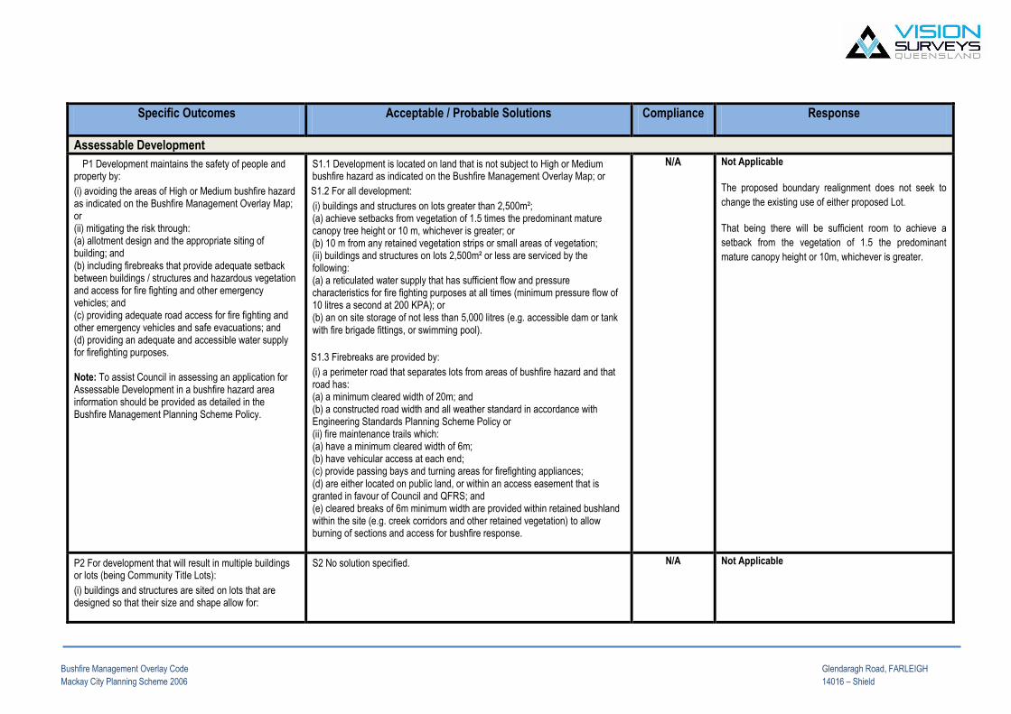
Bushfire Management Overlay Code Glendaragh Road, FARLEIGH
Mackay City Planning Scheme 2006 14016 – Shield
Specific Outcomes Acceptable / Probable Solutions Compliance Response
Assessable Development
P1 Development maintains the safety of people and property by:
(i) avoiding the areas of High or Medium bushfire hazard as indicated on the Bushfire Management Overlay Map; or (ii) mitigating the risk through: (a) allotment design and the appropriate siting of building; and (b) including firebreaks that provide adequate setback between buildings / structures and hazardous vegetation and access for fire fighting and other emergency vehicles; and (c) providing adequate road access for fire fighting and other emergency vehicles and safe evacuations; and (d) providing an adequate and accessible water supply for firefighting purposes. Note: To assist Council in assessing an application for Assessable Development in a bushfire hazard area information should be provided as detailed in the Bushfire Management Planning Scheme Policy.
S1.1 Development is located on land that is not subject to High or Medium bushfire hazard as indicated on the Bushfire Management Overlay Map; or
S1.2 For all development:
(i) buildings and structures on lots greater than 2,500m²; (a) achieve setbacks from vegetation of 1.5 times the predominant mature canopy tree height or 10 m, whichever is greater; or (b) 10 m from any retained vegetation strips or small areas of vegetation; (ii) buildings and structures on lots 2,500m² or less are serviced by the following: (a) a reticulated water supply that has sufficient flow and pressure characteristics for fire fighting purposes at all times (minimum pressure flow of 10 litres a second at 200 KPA); or (b) an on site storage of not less than 5,000 litres (e.g. accessible dam or tank with fire brigade fittings, or swimming pool).
S1.3 Firebreaks are provided by:
(i) a perimeter road that separates lots from areas of bushfire hazard and that road has: (a) a minimum cleared width of 20m; and (b) a constructed road width and all weather standard in accordance with Engineering Standards Planning Scheme Policy or (ii) fire maintenance trails which: (a) have a minimum cleared width of 6m; (b) have vehicular access at each end; (c) provide passing bays and turning areas for firefighting appliances; (d) are either located on public land, or within an access easement that is granted in favour of Council and QFRS; and (e) cleared breaks of 6m minimum width are provided within retained bushland within the site (e.g. creek corridors and other retained vegetation) to allow burning of sections and access for bushfire response.
N/A Not Applicable
The proposed boundary realignment does not seek to
change the existing use of either proposed Lot.
That being there will be sufficient room to achieve a
setback from the vegetation of 1.5 the predominant
mature canopy height or 10m, whichever is greater.
P2 For development that will result in multiple buildings or lots (being Community Title Lots):
(i) buildings and structures are sited on lots that are designed so that their size and shape allow for:
S2 No solution specified.
N/A Not Applicable
Bushfire Management Overlay Code Glendaragh Road, FARLEIGH
Mackay City Planning Scheme 2006 14016 – Shield
(a) efficient emergency access to buildings for firefighting appliances (e.g. by avoiding long narrow lots with long access drive to buildings); (b) setbacks and buildings siting
P3 Roads have:
(i) a maximum gradient of 12.5%; (ii) exclude cul de sacs, except where a perimeter road isolates the development from hazardous vegetation or the cul de sac is provided with an alternative access linking the cul de sac to other through roads.
S2 No solution specified.
N/A Not Applicable
There are no roads proposed.
Hazardous Materials
P4 Public safety and the environment are not adversely affected by the detrimental impacts of bushfire on hazardous materials manufactured or stored in bulk.
S2 No solution specified.
N/A Not Applicable
No hazardous material is stored or manufactured in bulk.

APPENDIX I
DEVELOPMENT ON STEEP LAND OVERLAY CODE
MACKAY CITY PLANNING SCHEME 2006

Development on Steep Land Overlay Code Glendaragh Road, FARLEIGH
Mackay City Planning Scheme 2006 14016 – Shield
Specific Outcomes Acceptable / Probable Solutions Response
Assessable Development
P1 No development is located on steep land or on any part of a site subject to landslide hazard from sloping land above the site17.
17 A site specific geotechnical analysis prepared by a registered professional engineer (NPER-3 Civil Engineer (geotechnical specialisation)) may be required to demonstrate that the site is not subject to landslide hazard and that the development will not impact on the long term stability of the site.
S1.1 Development is carried out only on parts of a site containing geologically stable land, or unlikely to be affected by surrounding unstable land.
Not Applicable
There is no development on steep land as part of the development
application.
S1.2 Buildings and structures are located on less steep parts of the site to allow natural land forms and vegetation to be maintained as much as possible.
Not Applicable
There is no development on steep land as part of the development
application.
There are no buildings or structures proposed.
P2 The land is geologically suitable having regard to :
(i) The construction of any buildings and other structures; (ii) Stormwater drainage and wastewater disposal; (iii) Onsite works for driveways, retaining walls, pools, dams, etc; and
(iv) Loss of existing vegetation.
S2 No solution specified. Not Applicable
Items mentioned in P2 are not incorporated in the proposal.
P3 Extensions to existing premises located on steep land are minimal.
S3 Where existing premises are located on steep land, development does not: (i) involve any new building work other than a minor extension of less than 20m² gross floor area to an existing building; or
Not Applicable
There is no extensions to an existing premise located over steep land.

Development on Steep Land Overlay Code Glendaragh Road, FARLEIGH
Mackay City Planning Scheme 2006 14016 – Shield
P4 Development located on steep land with an existing or proposed slope of 15% or more is certified18 as very low risk in accordance with the publication referenced in the guidelines to State Planning Policy 1/03; “Landscape Risk Management Concepts and Guidelines”, Australian Geomechanics Journal Vol 35, No. 1, March 2000.
18 The certifying engineer is to be a registered professional engineer,
specifically NPER-3 civil with geotechnical specialisation and registered to
practise in Queensland (RPEQ)
S4.1 Land in its pre-development condition is certified: (i) that the land is classified as very low risk, or
(ii) that the land will be able to be classified as very low risk after specified works have been carried out.
Not Applicable
S4.2 Land subject to development works related to reconfiguring a lot or material change of use is certified: (i) that the development works can be carried out without altering the very low classification of landslip risk, or (ii) that the development works can be carried out without altering the very low classification of landslip risk provided specified works are carried out and/or specified measures are taken during the course of the development works; and (iii) after completion of the works:
(a) that building and associated further development works can be carried out on the land without altering the very low classification of landslip risk, or
that building and associated further development works can be carried out on the land without altering the very low classification of landslip risk provided specified works are carried out and/or specified measures are taken during the course of the building and associated further development works.
Not Applicable
There is no development occurring as a result of the proposed
development application.
Reconfiguring a Lot
P5 Timbered and scenic ridgelines are maintained in their natural state.
S5 No solution specified. Not Applicable.
Operational Works
P6 The extent of excavation (cut) and fill is minimised and revegetated immediately following completion of the works.
S6.1 Earthworks does not: (i) involve a change in level of more than 1m relative to natural ground surface at any point; and
(ii) occur within 1.5m of any site boundary.
S6.2 Retaining walls are not constructed within 3m of a property
Not Applicable
No OW is involved in the application.

Development on Steep Land Overlay Code Glendaragh Road, FARLEIGH
Mackay City Planning Scheme 2006 14016 – Shield
boundary other than where retaining walls are less than 1m in height
on a continuous vertical plane.
P7 Paths, driveways, roads and other activity areas are designed to: (i) Follow the natural contours; (ii) Minimise the length of driveways and roads; and (iii) Minimise the number of crossings of water courses and
drainage lines.
S7 No solution specified. Not Applicable
No OW is involved in the application.
Stormwater
P8 Stormwater runoff is managed such that:
(i) Runoff from hard surfaces and drainage
installations is collected and discharged to a lawful
point of downstream discharge.
(ii) Any adverse impact on on-site natural
watercourses is prevented.
S8 No solution specified. Not Applicable
There is no stormwater runoff matters involved in the proposed
application. The proposal is based upon a boundary realignment.
Airlie Beach Office Mackay Office Moranbah Office Directors Unit 4, Gabriel Plaza, 55 Paluma Rd, Cannonvale Qld 4802 PO Box 103, Airlie Beach Qld 4802 Phone: 07 4948 3781 Fax: 07 4948 3233
33 River St, Mackay Qld 4740 PO Box 1730, Mackay Qld 4740 Phone: 07 4951 0768 Fax: 074953 0340
3 Griffin St, Moranbah Qld 4744 PO Box 200, Moranbah Qld 4744 Phone: 07 4941 9069
Brian Forrester David Wilson
Email: [email protected] www.visionsurveysqld.com.au ABN: 84 128 752 947
Our Ref: 14016 – Shield Title: Appendix J – Overlay Mapping
STEEP LAND OVERLAY
GOOD QUALITY AGRICULTURAL LAND OVERLAY
Airlie Beach Office Mackay Office Moranbah Office Directors Unit 4, Gabriel Plaza, 55 Paluma Rd, Cannonvale Qld 4802 PO Box 103, Airlie Beach Qld 4802 Phone: 07 4948 3781 Fax: 07 4948 3233
33 River St, Mackay Qld 4740 PO Box 1730, Mackay Qld 4740 Phone: 07 4951 0768 Fax: 074953 0340
3 Griffin St, Moranbah Qld 4744 PO Box 200, Moranbah Qld 4744 Phone: 07 4941 9069
Brian Forrester David Wilson
Email: [email protected] www.visionsurveysqld.com.au ABN: 84 128 752 947
BUSHFIRE MANAGEMENT OVERLAY
LANDSCAPE CHARACTER OVERLAY
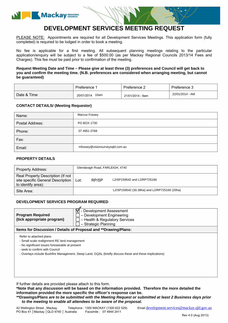
42 Wellington Street , Mackay Telephone : 1300 MACKAY (1300 622 529) Email [email protected] PO Box 41 │Mackay │QLD 4740 │ Australia Facsimile : 07 4944 2411 Rev 4.0 (Aug 2013)
DEVELOPMENT SERVICES MEETING REQUEST PLEASE NOTE: Appointments are required for all Development Services Meetings. This application form (fully completed) is required to be lodged in order to book a meeting. No fee is applicable for a first meeting. All subsequent planning meetings relating to the particular application/enquiry will be subject to a fee of $500.00 (as per Mackay Regional Councils 2013/14 Fees and Charges). This fee must be paid prior to confirmation of the meeting. Request Meeting Date and Time – Please give at least three (3) preferences and Council will get back to you and confirm the meeting time. (N.B. preferences are considered when arranging meeting, but cannot be guaranteed)
Preference 1 Preference 2 Preference 3
Date & Time
CONTACT DETAILS/ (Meeting Requestor)
Name:
Postal Address:
Phone:
Fax:
Email:
PROPERTY DETAILS
Property Address:
Real Property Description (If not site specific General Description to identify area):
Lot: RP/SP
Site Area:
DEVELOPMENT SERVICES PROGRAM REQUIRED
Program Required (tick appropriate program)
- Development Assessment – Development Engineering – Health & Regulatory Services – Strategic Planning
Items for Discussion / Details of Proposal and **Drawing/Plans:
If further details are provided please attach to this form. *Note that any discussion will be based on the information provided. Therefore the more detailed the information provided the more specific the officer’s response can be. **Drawings/Plans are to be submitted with the Meeting Request or submitted at least 2 Business days prior
to the meeting to enable all attendees to be aware of the proposal.
20/01/2014 21/01/2014 - 9am10am 22/01/2014 - AM
Marcus Fossey
PO BOX 1730
07 4951 0768
Glendaragh Road, FARLEIGH, 4740
L2/SP159542 and L2/RP725166
L2/SP159542 (30.38ha) and L2/RP725166 (20ha)
Refer to attached plans - Small scale realignment RE land management - No significant issues foreseeable at present - seek to confirm with Council - Overlays include Bushfire Management, Steep Land, GQAL (briefly discuss these and these implications)

42 Wellington Street , Mackay Telephone : 1300 MACKAY (1300 622 529) Email [email protected] PO Box 41 │Mackay │QLD 4740 │ Australia Facsimile : 07 4944 2411 Rev 4.0 (Aug 2013)
MEETING PARTICIPANTS (Maximum 4 applicant representatives)
Applicant Representatives Name Role (eg. Owner or Consultant)
DETAILS OF PREVIOUS CONTACT WITH COUNCIL (Date & which officer/s involved)
Once a meeting time has been established a tentative booking will be placed in the Council officer’s diary and notification of the meeting time will be sent to the requestor. A confirmation from the requestor will be required, if no confirmation from the requestor has been provided within 24 hours the meeting will be deleted and a new meeting request will have to be made if the meeting is still required. DECLARATION In lodging this request for a meeting I/We ……..………………………… acknowledge that: This meeting is intended to: Confirm Council requirements (Planning Scheme, Policies, Local Laws) Identify Council information requirements (additional studies) Identify Council approvals required Identify need for referral to other agencies Identify design issues that will need to be addressed based on a preliminary assessment Explore possible solutions to those issues Provide clarity about the assessment process and potential timeframes This meeting is not intended to: Provide a detailed assessment of the proposal Indicate the likely outcome of the ensuing assessment process Provide a detailed compliance audit of the proposal against applicable codes / local laws or other Council
requirements Speculate on Council’s view on specific issues Provide feedback on issues other than that for which the meeting was requested. Signature(s) ________________________________________________________________________ Date ______________________________________________________________________________ Mackay Regional Council is collecting your personal information in order to process your application. This information will only be disclosed to any other third party with your written authorisation or as we are required to by law.
Marcus Fossey COnsultant
n/a
Marcus Fossey
16/01/2014

APPENDIX K – PRELODGEMENT MEETING REQUEST FORM (MRC)
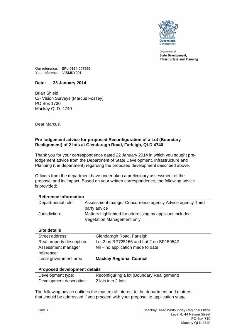
Page 1 Mackay Isaac Whitsunday Regional OfficeLevel 4, 44 Nelson Street
PO Box 710Mackay QLD 4740
Our reference: SPL-0114-007589Your reference: VISMKY001
Date: 23 January 2014
Brian ShieldC/- Vision Surveys (Marcus Fossey)PO Box 1730Mackay QLD 4740
Dear Marcus,
Pre-lodgement advice for proposed Reconfiguration of a Lot (BoundaryRealignment) of 2 lots at Glendaragh Road, Farleigh, QLD 4740
Thank you for your correspondence dated 22 January 2014 in which you sought pre-lodgement advice from the Department of State Development, Infrastructure andPlanning (the department) regarding the proposed development described above.
Officers from the department have undertaken a preliminary assessment of theproposal and its impact. Based on your written correspondence, the following adviceis provided:
Reference informationDepartmental role: Assessment manger Concurrence agency Advice agency Third
party adviceJurisdiction: Matters highlighted for addressing by applicant included
Vegetation Management only
Site detailsStreet address: Glendaragh Road, FarleighReal property description: Lot 2 on RP725166 and Lot 2 on SP159542Assessment managerreference:
Nil – no application made to date
Local government area: Mackay Regional Council
Proposed development detailsDevelopment type: Reconfiguring a lot (Boundary Realignment)Development description: 2 lots into 2 lots
The following advice outlines the matters of interest to the department and mattersthat should be addressed if you proceed with your proposal to application stage.

Department of State Development, Infrastructure and Planning Page2
Pre-lodgement adviceItem AdviceDepartment of Natural Resources and Mines (DNRM) regarding Vegetation Management
1. The proposed boundary realignment for Lot 2 on RP725166 and Lot 2 on SP159542 asshown in the document titled Shield Proposal provided by Vision Surveys with the pre-lodgement request, does not trigger for Vegetation Management
2. The Vegetation Map provided by Vision Surveys with the pre-lodgement request has beendisregarded, as it focuses on a different parcel of land (being Lot 201 on SP225070)
This pre-lodgement advice does not constitute an approval or an endorsement thatthe department supports the development proposal. Additional information may berequired to allow the department to properly assess the development proposal whena formal application has been lodged.
If you require any further information, please contact Alice Slark, Senior PlanningOfficer, Mackay Isaac Whitsunday Regional Office, on (07) 4898 6815 who will bepleased to assist.
Yours sincerely
Jamie ThorleyManager (Planning) – Mackay Isaac Whitsunday Regional Office

APPENDIX L – PRELODGEMENT ADVICE DSDIP (SPL-0114-007589)
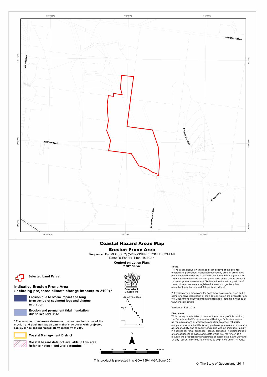
JENSENS ROAD
HOLTS ROAD
WAIN
AI R
OAD
GLEN
DARA
GH R
OAD
P ALM RIDGE DR IVE
WADDELLS ROAD
149 °7'30 "E
149 °7'30 "E
149 °7'0"E
149 °7'0"E
149 °6'30 "E
149 °6'30 "E21
°5'0"
S
21°5
'0"S
21°5
'30"S
21°5
'30"S
21°6
'0"S
21°6
'0"S
Coastal Hazard Areas MapErosion Prone Area
¯© The State of Queensland, 2014
Requested By: [email protected]: 05 Feb 14 Time: 15.49.14
Centred on Lot on Plan:2 SP159542
This product is projected into GDA 1994 MGA Zone 55
0 130 260 390 520 650 m
LOCALITY D IAGRAMErosion due to storm impact and longterm trends of sediment loss and channelmigrationErosion and permanent tidal inundationdue to sea level rise
* The erosion prone areas shown on th is map are indicative of theerosion and tidal inundation extent that may occur with projectedsea level rise and increased storm intensity at 2100.
Notes1. The areas shown on this map are indicative of the extent oferosion and permanent inundation defined by erosion prone areaplans declared under the Coastal Protection and Management Act1995. Only the declared erosion prone area plans should be usedfor development assessment. To determine the actual position ofthe erosion prone area a registered surveyor or geotechnicalconsultant may be required if there is any doubt.
2. Erosion prone area plans for each local government area and acomprehensive description of their determination are available fromthe Department of Environment and Heritage Protection website atwww.ehp.qld.gov.auVersion 2 - Feb 2013
DisclaimerWhilst every care is taken to ensure the accuracy of this product,the Department of Environment and Heritage Protection makesno representations or warranties about its accuracy, reliability,completeness or suitability for any particular purpose and disclaimsall responsibility and all liability (including without l imitation, l iabil ityin negligence) for all expenses, losses, damages (including indirector consequential damage) and costs which you may incur as aresult of the product being inaccurate or incomplete in any way andfor any reason. This map is intended to be printed on an A4 page.
Coastal Management DistrictCoastal hazard data not available in this area
Selected Land Parcel
Indicative Erosion Prone Area(including projected climate change impacts to 2100) *
Refer to notes 1 and 2 to determine
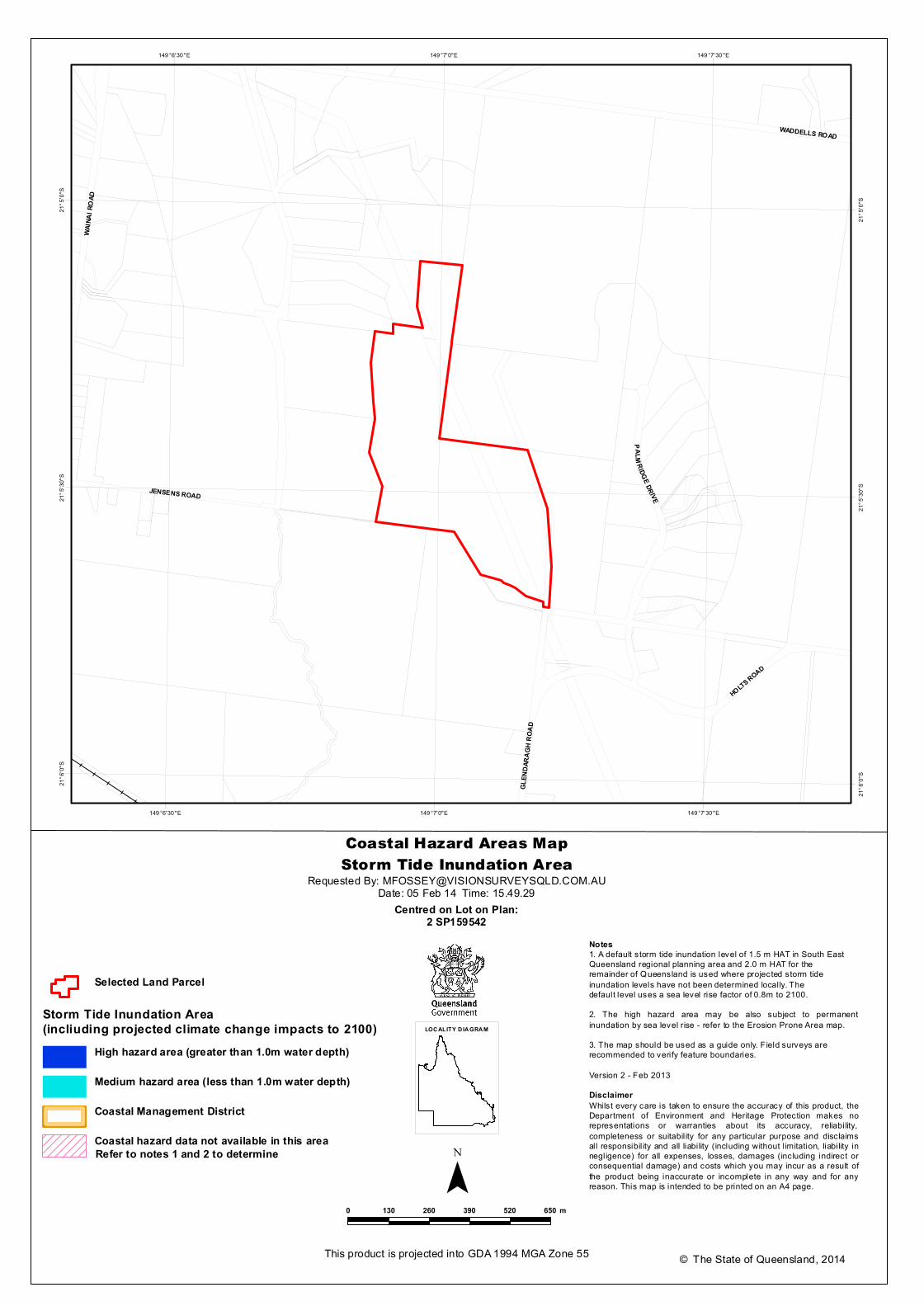
JENSENS ROAD
HOLTS ROAD
WAIN
AI R
OAD
GLEN
DARA
GH R
OAD
P ALM RIDGE DR IVE
WADDELLS ROAD
149 °7'30 "E
149 °7'30 "E
149 °7'0"E
149 °7'0"E
149 °6'30 "E
149 °6'30 "E21
°5'0"
S
21°5
'0"S
21°5
'30"S
21°5
'30"S
21°6
'0"S
21°6
'0"S
Coastal Hazard Areas MapStorm Tide Inundation Area
¯© The State of Queensland, 2014
Requested By: [email protected]: 05 Feb 14 Time: 15.49.29
Centred on Lot on Plan:2 SP159542
This product is projected into GDA 1994 MGA Zone 55
0 130 260 390 520 650 m
LOCALITY D IAGRAM
Selected Land Parcel
Notes1. A default storm tide inundation level of 1.5 m HAT in South EastQueensland regional planning area and 2.0 m HAT for theremainder of Queensland is used where projected storm tideinundation levels have not been determined locally. Thedefault level uses a sea level rise factor of 0.8m to 2100.2. The high hazard area may be also subject to permanentinundation by sea level rise - refer to the Erosion Prone Area map.3. The map should be used as a guide only. Field surveys arerecommended to verify feature boundaries.
Version 2 - Feb 2013DisclaimerWhilst every care is taken to ensure the accuracy of this product, theDepartment of Environment and Heritage Protection makes norepresentations or warranties about its accuracy, reliability,completeness or suitabil ity for any particular purpose and disclaimsall responsibil ity and all liability (including without l imitation, liability innegligence) for all expenses, losses, damages (including indirect orconsequential damage) and costs which you may incur as a result ofthe product being inaccurate or incomplete in any way and for anyreason. This map is intended to be printed on an A4 page.
Refer to notes 1 and 2 to determine
High hazard area (greater than 1.0m water depth)
Medium hazard area (less than 1.0m water depth)
Coastal Management District
Coastal hazard data not available in this area
Storm Tide Inundation Area(incliuding projected climate change impacts to 2100)

1
Marcus Fossey
From: [email protected]
Sent: Wednesday, 5 February 2014 3:49 PM
Subject: Map Request Error Occurred
Your map request has failed for the following reason:
Lot 2 on plan SP159542 is NOT in the Coastal Zone.
------------------------------
The information in this email together with any attachments is intended only for the person or entity to which it is
addressed and may contain confidential and/or privileged material. There is no waiver of any
confidentiality/privilege by your inadvertent receipt of this material.
Any form of review, disclosure, modification, distribution and/or publication of this email message is prohibited,
unless as a necessary part of Departmental business.
If you have received this message in error, you are asked to inform the sender as quickly as possible and delete this
message and any copies of this message from your computer and/or your computer system network.
------------------------------
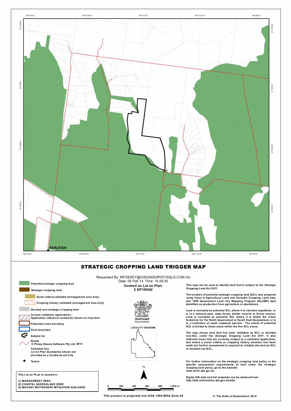
!
FARLEIGH149 °8'0"E
149 °8'0"E
149 °7'30 "E
149 °7'30 "E
149 °7'0"E
149 °7'0"E
149 °6'30 "E
149 °6'30 "E
149 °6'0"E
149 °6'0"E
21°4
'30"S
21°4
'30"S
21°5
'0"S
21°5
'0"S
21°5
'30"S
21°5
'30"S
21°6
'0"S
21°6
'0"S
STRATEGIC CROPPING LAND TRIGGER MAP
¯© The State of Queensland, 2014
Requested By: [email protected]: 05 Feb 14 Time: 15.49.25
Centred on Lot on Plan:2 SP159542
This product is projected into GDA 1994 MGA Zone 55
0 200 400 600 800 1,000 m
LOCALITY DIAGRAM
This map can be used to identify land that is subject to the StrategicCropping Land Act 2011 .The location of potential strategic cropping land (SCL) was preparedusing Class A Agricultural Land and Versatile Cropping Land dataand 1999 Queensland Land Use Mapping Program (QLUMP) dataidentified as production from agriculture or plantations.Land is excluded as potential SCL where it is remnant vegetation, oris in a national park, state forest, timber reserve or forest reserve.Land is excluded as potential SCL where it is within the urbanfootprints for Far North Queensland or South East Queensland, or isin a collection of small cadastral parcels. The extent of potentialSCL is limited to those areas within the five SCL zones.The map shows land that has been validated as SCL or decidednon-SCL under the Strategic Cropping Land Act 2011 . It alsoindicates areas that are currently subject to a validation application,and where a zonal criteria or cropping history decision has beenmade but further assessment is required to validate the land as SCLor decided non-SCL.
For further information on the strategic cropping land policy or thespecific assessment requirements of land under the strategiccropping land policy, go to the website:www.dnrm.qld.gov.au
Digital GIS data and full metadata can be obtained fromhttp://dds.information.qld.gov.au/dds/
This Lot on PLan is located in:(1) MANAGEMENT AREA(2) COASTAL QUEENSLAND ZONE(3) MACKAY WHITSUNDAY MITIGATION SUB-ZONE
2014
Potential strategic cropping land
Strategic cropping land
Zonal criter ia validated (management area only)Cropping history validated (management area only)
Decided non-strategic cropping landCurrent validation applicationsApplication reference number(s) shown on map faceProtection area boundaryZone boundarySubject lotRoads © Pitney Bowes Software Pty LtdCadastral lineLot on Plan boundaries shown areprovided as a locational aid only
! Towns

APPENDIX M – REFERRAL MAPPING SEARCHES
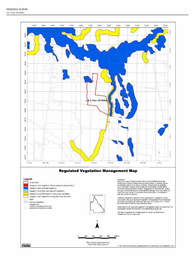
05/02/2014 15:49:56Lot: '2' Plan: 'SP159542'
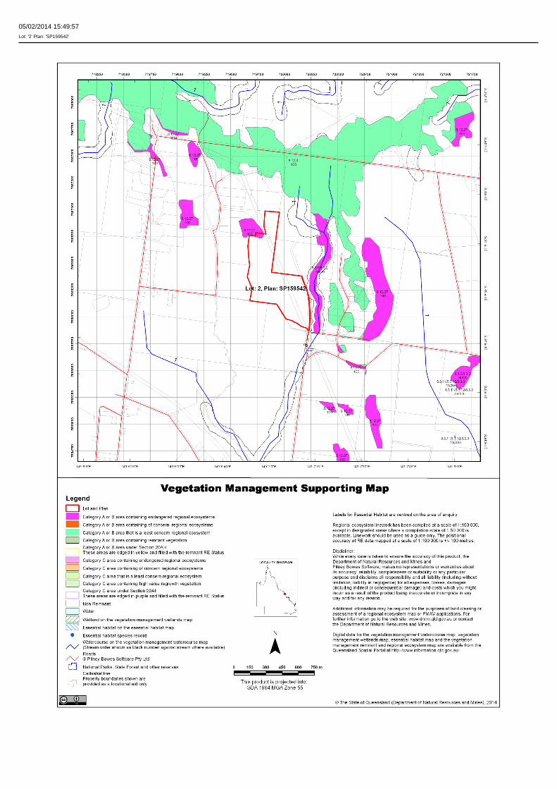
05/02/2014 15:49:57Lot: '2' Plan: 'SP159542'

05/02/2014 15:49:59Lot: '2' Plan: 'SP159542'
Vegetation Management Act 1999 - Extract from the essential habitat database - version 4.0
Essential habitat is required for assessment under the:
• State Development Assessment Provisions - Module 8: Native vegetation clearing which sets out the matters of interest to the state for development assessment under the Sustainable PlanningAct 2009; and
• Self-assessable vegetation clearing codes made under the Vegetation Management Act 1999
Essential habitat for one or more of the following species is found on and within 1.1 km of the identified subject lot/s or on and within 2.2 km of an identified coordinate on the accompanying essential habitatmap.
This report identifies essential habitat in Category A, B and Category C areas.
The numeric labels on the essential habitat map can be cross referenced with the database below to determine which essential habitat factors might exist for a particular species.
Essential habitat is compiled from a combination of species habitat models and buffered species records.
The Department of Natural Resources and Mines website (http://www.dnrm.qld.gov.au) has more information on how the layer is applied under the State Development Assessment Provisions - Module 8:Native vegetation clearing and the Vegetation Management Act 1999.
Regional ecosystem is a mandatory essential habitat factor, unless otherwise stated.
Essential habitat, for protected wildlife, means a category A area, a category B area or category C area shown on the regulated vegetation management map-
(a) that has at least 3 essential habitat factors for the protected wildlife that must include any essential habitat factors that are stated as mandatory for the protected wildlife in the essential habitatdatabase; or
(b) in which the protected wildlife, at any stage of its life cycle, is located.
Essential habitat identifies endangered or vulnerable native wildlife prescribed under the Nature Conservation Act 1994.
Essential habitat in Category A and B (Remnant vegetation species record) areas:1100m Species Information - (no results)
Essential habitat in Category A and B (Remnant vegetation species record) areas:1100m Regional Ecosystems Information - (no results)
Essential habitat in Category A and B (Remnant vegetation) areas:1100m Species Information - (no results)
Essential habitat in Category A and B (Remnant vegetation) areas:1100m Regional Ecosystems Information - (no results)
Essential habitat in Category C (High value regrowth vegetation) areas:1100m Species Information - (no results)
Essential habitat in Category C (High value regrowth vegetation) areas:1100m Regional Ecosystems Information - (no results)

APPENDIX N
STATE DEVELOPMENT ASSESSMENT PROVISIONS –
6.1 PARTICULAR DEVELOPMENT ON STRATEGIC CROPPING LAND CODE

6.1 Particular Development on Strategic Cropping Land Glendaragh Road, FARLEIGH
State Development Assessment Provisions 14016 – Shield
Table 6.1.3: Reconfiguring a lot
Performance outcomes Acceptable outcomes Response Comment
PO1 The area available for cropping and the area of strategic cropping land which has the opportunity for cropping, is maintained or enhanced.
AO1.1 No additional domestic housing activity will result from the development unless they are located in an area not strategic cropping land or an area that is not an area available for cropping.
AND
Complies
There is no additional domestic housing activity being proposed.
The proposal intends to shift a boundary for land management purposes and will not impact upon the Strategic Cropping Land.
AO1.2 Lot boundaries are located in an area that is not strategic cropping land or is not available for cropping.
Complies
The realigned lot boundaries are not located in SCL.
It is noted the SCL occurs around the outside of the property.