Embed Size (px)
Citation preview
Geoinformatica (2015) 19:525–565DOI 10.1007/s10707-014-0220-8
Recommendations in location-based socialnetworks: a survey
Jie Bao · Yu Zheng · David Wilkie · Mohamed Mokbel
Received: 23 September 2013 / Revised: 23 August 2014 /Accepted: 15 September 2014 / Published online: 6 February 2015© Springer Science+Business Media New York 2015
Abstract Recent advances in localization techniques have fundamentally enhanced socialnetworking services, allowing users to share their locations and location-related contents,such as geo-tagged photos and notes. We refer to these social networks as location-basedsocial networks (LBSNs). Location data bridges the gap between the physical and digitalworlds and enables a deeper understanding of users’ preferences and behavior. This additionof vast geo-spatial datasets has stimulated research into novel recommender systems thatseek to facilitate users’ travels and social interactions. In this paper, we offer a systematicreview of this research, summarizing the contributions of individual efforts and exploringtheir relations. We discuss the new properties and challenges that location brings to rec-ommender systems for LBSNs. We present a comprehensive survey analyzing 1) the datasource used, 2) the methodology employed to generate a recommendation, and 3) the objec-tive of the recommendation. We propose three taxonomies that partition the recommendersystems according to the properties listed above. First, we categorize the recommender sys-tems by the objective of the recommendation, which can include locations, users, activities,or social media. Second, we categorize the recommender systems by the methodologiesemployed, including content-based, link analysis-based, and collaborative filtering-basedmethodologies. Third, we categorize the systems by the data sources used, including userprofiles, user online histories, and user location histories. For each category, we summarizethe goals and contributions of each system and highlight the representative research effort.
J. Bao (�) · M. MokbelUniversity of Minnesota, Minneapolis, MN, USAe-mail: [email protected]
M. Mokbele-mail: [email protected]
Y. ZhengMicrosoft Research, Beijing, Chinae-mail: [email protected]
D. WilkieUniversity of North Carolina, Wilmington, NC, USAe-mail: [email protected]
526 Geoinformatica (2015) 19:525–565
Further, we provide comparative analysis of the recommender systems within each cate-gory. Finally, we discuss the available data-sets and the popular methods used to evaluate theperformance of recommender systems. Finally, we point out promising research topics forfuture work. This article presents a panorama of the recommender systems in location-basedsocial networks with a balanced depth, facilitating research into this important researchtheme.
Keywords Location-based social networks · Recommender systems · Location-basedservices · Location recommendations · Friend recommendations · Communitydiscoveries · Activity recommendations · Social media recommendations
1 Introduction
With millions of users, social networking services like Facebook and Twitter have becomesome of the most popular Internet applications. The rich knowledge that has accumulatedin these social sites enables a variety of recommender systems for new friends and media.
Recently, advances in location-acquisition and wireless communication technologieshave enabled the creation of location-based social networking services, such as Foursquare,Twinkle, and GeoLife [131]. In such a service, users can easily share their geo-spatial loca-tions and location-related contents in the physical world via online platforms. For example,a user with a mobile phone can share comments with his friends about a restaurant at whichhe has dined via an online social site. Other users can expand their social networks usingfriend suggestions derived from overlapped location histories. For instance, people whoconstantly hike on the same mountain can be put in contact.
The location dimension bridges the gap between the physical world and the digital onlinesocial networking services, giving rise to new opportunities and challenges in traditionalrecommender systems in the following aspects:
1. Complex objects and relations: A location is a new object in location-based socialnetworks (LBSNs), generating new relations between users, between locations, andbetween users and locations. New recommendation scenarios, like location anditinerary recommendations, can be enabled using this new knowledge, and tradi-tional recommendation scenarios, such as friend and media recommendation, can beenhanced. However, doing so requires new methodologies for generating high-qualityrecommendations.
2. Rich knowledge: A location is one of the most important components defining a user’scontext. Extensive knowledge about a user’s behavior and preferences can be learnedvia their location history [113]. The huge volume of location-related data generatedby users improves the likelihood that social opinions, e.g., the most favorite dish in arestaurant or the most popular activity at a point of interest, can be accurately assessedby recommender systems.
These opportunities and challenges have been tackled by many new approaches to rec-ommender systems, using different data sources and methodologies to generate differentkinds of recommendations. In this article, we provide a survey of these systems, and the pub-lications proposing them, with a systematic review on over sixty articles published over thelast five years in the major journals, conferences, and workshops, including but not limitedto KDD, WWW, Ubicomp, ACM SIGSPATIAL, LBSN, RecSys, ACM TIST, and VLDB.
Geoinformatica (2015) 19:525–565 527
For each publication, we analyze 1) what a produced recommendation is (i.e., the objectiveof a recommendation), 2) the methodology employed to generate a recommendation, and3) the data source it used. According to these three aspects, we propose three taxonomiesto respectively partition the recommender systems. This survey presents a panorama ofthe recommendations in location-based social networks with a balanced depth, facilitatingresearch into this rising topic. The contributions of this article are detailed as follows:
– We distinguish LBSNs from conventional social networks and define their uniqueproperties, challenges, and opportunities.
– We categorize the major recommender systems for LBSNs in three taxonomies,organized by data sources, methodologies, and recommendation objectives. In eachcategory, we summarize the goals and contributions of each system. In addition, wehighlight one representative system in each category, providing a more in-depth viewof the methodology.
– We summarize the public LBSN datasets and the major methods for evaluating therecommendations in LBSNs.
– We point out promising research directions in LBSN recommender systems, payingspecial attention to directions that result from the analysis and synthesis of the differentrecommender system categories.
The rest of the paper is organized as follows: In Section 2, we provide an overviewof location-based social networks. We then propose taxonomies for existing recommendersystems for LBSNs in the three subsequent sections. In Section 3, we propose a taxon-omy organized by objective of the recommendations. In Section 4, we propose a taxonomyorganized by the methodology of the recommendation system. In Section 5, we propose ataxonomy organized by the data source used by the recommender systems. In Section 6, wesummarize the datasets and major methods for evaluating a recommendation in an LBSN.In Section 7, we present potential future research directions and discuss how they relate tothe existing recommender systems. Finally, in Section 8 we present our concluding remarks.
2 Overview
In this section, we first present a formal definition of location-based social networks. Afterthat, we summarize the unique properties of locations as the new data type and discuss thenew challenges they bring to recommender systems for LBSNs.
2.1 Concepts of location-based social networks
A social network is an abstract structure contains different relations between the individuals,such as friendships, common interests, and shared knowledge. An online social networkingservice is a participatory digital representation of real-world social networks. The socialnetworking services reveal user’s real social connections, and also enhance the growth byallowing them to share and communicate about ideas, activities, events, news, and interestsin a much easier fashion.
The addition of spatial aspect in a location-based social networking service strengthensthe connection between the social networking services and the real-world social networks.Location-based Social Networks or Geosocial Network is formally defined as a type ofsocial networking in which geographic services and capabilities such as geocoding and
528 Geoinformatica (2015) 19:525–565
geotagging are used to enable additional social dynamics [78]. Zheng further elaborate theconcept for these location-based social networks [137], as:
“A location-based social network (LBSN) does not only mean adding a location toan existing social network so that people in the social structure can share location-embedded information, but also consists of the new social structure made up ofindividuals connected by the interdependency derived from their locations in the phys-ical world as well as their location-tagged media content, such as photos, video, andtext. Here, the physical location consists of the instant location of an individual at agiven timestamp and the location history that an individual has accumulated in a cer-tain period. Further, the interdependency includes not only that two persons co-occurin the same physical location or share similar location histories but also the knowl-edge, e.g., common interests, behaviors, and activities, inferred from an individual’slocation (history) and location-tagged data.”
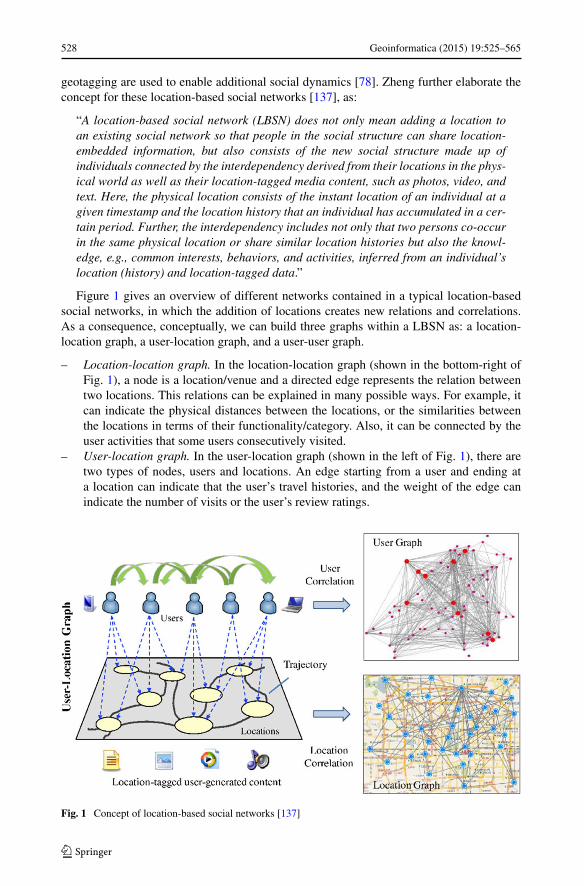
Figure 1 gives an overview of different networks contained in a typical location-basedsocial networks, in which the addition of locations creates new relations and correlations.As a consequence, conceptually, we can build three graphs within a LBSN as: a location-location graph, a user-location graph, and a user-user graph.
– Location-location graph. In the location-location graph (shown in the bottom-right ofFig. 1), a node is a location/venue and a directed edge represents the relation betweentwo locations. This relations can be explained in many possible ways. For example, itcan indicate the physical distances between the locations, or the similarities betweenthe locations in terms of their functionality/category. Also, it can be connected by theuser activities that some users consecutively visited.
– User-location graph. In the user-location graph (shown in the left of Fig. 1), there aretwo types of nodes, users and locations. An edge starting from a user and ending ata location can indicate that the user’s travel histories, and the weight of the edge canindicate the number of visits or the user’s review ratings.
Fig. 1 Concept of location-based social networks [137]
Geoinformatica (2015) 19:525–565 529
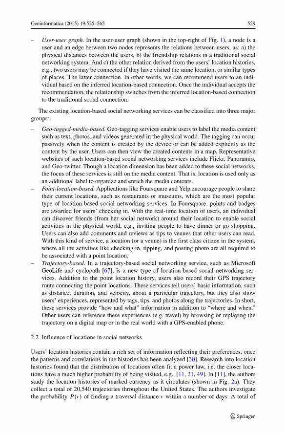
– User-user graph. In the user-user graph (shown in the top-right of Fig. 1), a node is auser and an edge between two nodes represents the relations between users, as: a) thephysical distances between the users, b) the friendship relations in a traditional socialnetworking system. And c) the other relation derived from the users’ location histories,e.g., two users may be connected if they have visited the same location, or similar typesof places. The latter connection. In other words, we can recommend users to an indi-vidual based on the inferred location-based connection. Once the individual accepts therecommendation, the relationship switches from the inferred location-based connectionto the traditional social connection.
The existing location-based social networking services can be classified into three majorgroups:
– Geo-tagged-media-based. Geo-tagging services enable users to label the media contentsuch as text, photos, and videos generated in the physical world. The tagging can occurpassively when the content is created by the device or can be added explicitly as thecontent by the user. Users can then view the created contents in a map. Representativewebsites of such location-based social networking services include Flickr, Panoramio,and Geo-twitter. Though a location dimension has been added to these social networks,the focus of these services is still on the media content. That is, location is used only asan additional label to organize and enrich the media contents.
– Point-location-based. Applications like Foursquare and Yelp encourage people to sharetheir current locations, such as restaurants or museums, which are the most populartype of location-based social networking services. In Foursquare, points and badgesare awarded for users’ checking in. With the real-time location of users, an individualcan discover friends (from her social network) around their location to enable socialactivities in the physical world, e.g., inviting people to have dinner or go shopping.Users can also add comments and reviews as tips to venues that other users can read.With this kind of service, a location (or a venue) is the first class citizen in the system,where all the activities like checking in, tipping, and posting photo are all required tobe associated with a point location.
– Trajectory-based. In a trajectory-based social networking service, such as MicrosoftGeoLife and cyclopath [67], is a new type of location-based social networking ser-vices. Addition to the point location history, users also record their GPS trajectoryroute connecting the point locations. These services tell users’ basic information, suchas distance, duration, and velocity, about a particular trajectory, but they also showusers’ experiences, represented by tags, tips, and photos along the trajectories. In short,these services provide “how and what” information in addition to “where and when.”Other users can reference these experiences (e.g. travel) by browsing or replaying thetrajectory on a digital map or in the real world with a GPS-enabled phone.
2.2 Influence of locations in social networks
Users’ location histories contain a rich set of information reflecting their preferences, oncethe patterns and correlations in the histories has been analyzed [30]. Research into locationhistories found that the distribution of locations often fit a power law, i.e. the closer loca-tions have a much higher probability of being visited, e.g., [11, 21, 49]. In [11], the authorsstudy the location histories of marked currency as it circulates (shown in Fig. 2a). Theycollect a total of 20,540 trajectories throughout the United States. The authors investigatethe probability P(r) of finding a traversal distance r within a number of days. A total of
530 Geoinformatica (2015) 19:525–565
Fig. 2 Location Influences in LBSNs [11, 73]
14,730 (that is, a fraction Q = 0.71) secondary reports occurred outside a short range radiusLmin = 10 km. The distribution shows power-law behavior P(r) r(1+β) with an exponentβ = 0.59 ± 0.02. Recent investigations found similar patterns in users’ location histories inLBSNs. For example, [73] studies a large point-location data set collected from Foursquarethat reveals several patterns: a user’s activities are different during the weekdays and week-ends, and the spatio-temporal patterns of users’ check-ins fit the power law distribution.They found that 20 % of the user’s check-ins occur within a distance of 1 km, 60 % occurbetween 1 and 10 km, 20 % occur between 10 km and 100 km, and a small percentageextend to distances beyond 100 km. Analysis such as the above, coupled with investigationsinto user and location correlations and patterns, provide clues of user preferences that canguide recommender systems.
2.3 Unique properties of locations
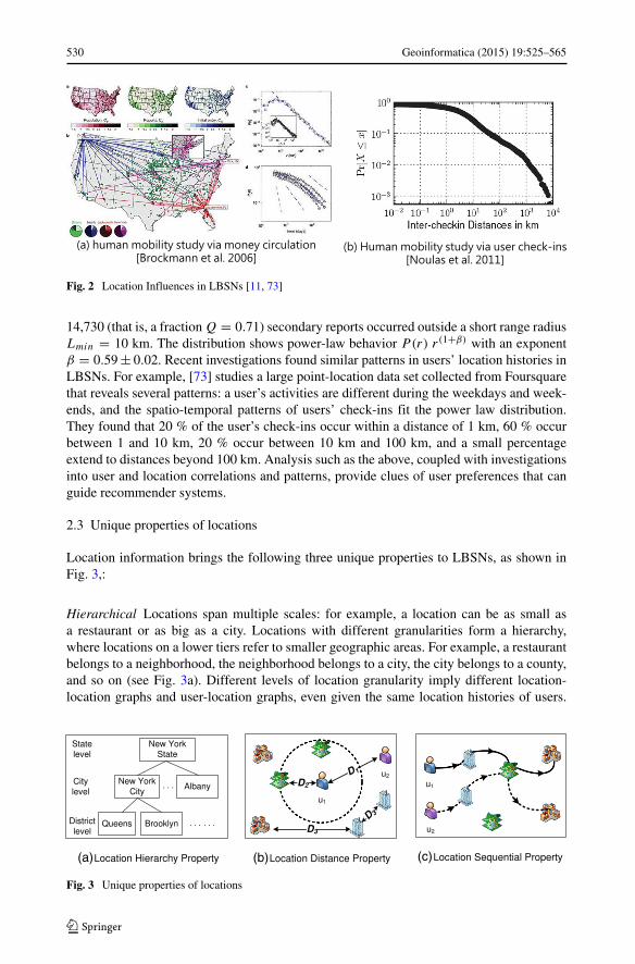
Location information brings the following three unique properties to LBSNs, as shown inFig. 3,:
Hierarchical Locations span multiple scales: for example, a location can be as small asa restaurant or as big as a city. Locations with different granularities form a hierarchy,where locations on a lower tiers refer to smaller geographic areas. For example, a restaurantbelongs to a neighborhood, the neighborhood belongs to a city, the city belongs to a county,and so on (see Fig. 3a). Different levels of location granularity imply different location-location graphs and user-location graphs, even given the same location histories of users.
Fig. 3 Unique properties of locations
Geoinformatica (2015) 19:525–565 531
These hierarchical relationships need to be considered as, for example, users who sharelocations at a lower level (such as a restaurant) likely have a stronger connection than thosewho share locations at a higher level (such as living in the same city). This hierarchicalproperty is unique in LBSNs, as it does not hold in an academic social network, where aconference never belongs to others.
Measurable distances Connecting the physical world to a LBSN leads to three new geospa-tial distance relations, the distance between different users’ locations (shown as D1 inFig. 3b), the distance between a user and a location (shown as D2 in Fig. 3b), and thedistance between two locations (shown as D3 in Fig. 3b). According to the first law of geog-raphy posed by Waldo Tobler [97], “everything is related to everything else, but near thingsare more related than distant things”, we propose that distance affects an LBSN in the fol-lowing three ways. 1) The user-user distance influences the similarity between users. Forexample, users with a history of visiting nearby locations are more likely to have similarinterests and preferences [56, 105], and users who live close to each other are more likely tobe friends [26]. 2) The user-location distance influences the likelihood a user will be inter-ested in a location. For instance, users in Foursquare visit restaurants close to their homesmore frequently than others [55]. 3) The location-location distance affects the correlationsbetween locations. For example, car dealerships are often placed close to each other.
Sequential ordering Subsequent visits by a user to two locations creates a relation witha chronological ordering. For instance, the two users in Fig. 3c share a location visitingpattern. From the time of each visit, we can create an ordering which may indicate somesimilarities between their preferences [129] or may imply traffic conditions [96].
2.4 Challenges to recommendations in LBSNs
While creating new opportunities for LBSNs, the unique properties of locations also bringnew challenges such as 1) location context awareness, 2) the heterogeneous domain, and3) the rate of growth.
2.4.1 Location context awareness
Recommender systems in LBSNs need to consider how the current location of a user,the location history of the user, and the location histories of other users influences whatrecommendation to make.
The current location of a user A user’s current location plays a vital role in generatingrecommendations in LBSNs due to the following three reasons.
First, a user’s current location can be represented on different levels of granularity (thehierarchical property of locations). Choosing a proper granularity for the recommendationscenario is important and challenging. For instance, we should use a fine granularity whenrecommending restaurants to a user, while a relatively coarse granularity (like in a city orstate) for local news recommendations.
Second, the distance property of locations implies that people are more likely to visitnearby locations than distant ones. However, the quality of a location (like a restaurant) isalso important for recommendation-making. Ranking a recommendation based on both theuser-location distance and the quality of a location is non-trivial. Further, a location indicatesa spatial constraint for generating recommendations, but also influences user preferences.
532 Geoinformatica (2015) 19:525–565
For example, beaches might be given a high recommendation rank to a user traveling toHawaii, even though the user prefers sporting events more than beaches typically. The sameuser may be more interested in seeing the status of her friends living in Hawaii. An addi-tional challenge is that fine grain location needs to be taken into account quickly: usersoften access LBSNs via mobile devices that frequently update their location information.Addressing this requires efficient algorithms to generate recommendations quickly.
Third, due to the sequential property of locations, a user’s current location affects futuretravel decisions. For instance, the majority of people visiting Tiananmen Square will sub-sequently travel to the Forbidden City, or a dessert or drink recommendation may beappropriate after visiting certain restaurants. Discovering these sequential relations andincorporating them into recommendations presents subtle challenges.
The historical locations of the user Earlier works, e.g., [29, 31], have suggest that a user’shistorical behaviors is a powerful indicator of the user’s preferences. A user’s historicallocations accumulated in an LBSN (e.g., check-ins and geo-tagged photos) reflect moreaccurately a user’s experiences, living patterns, preferences and interests than the user’sonline behaviors [137]. However, it is non-trivial to model a user’s location history due tothe hierarchy, distance, and sequential properties of locations. Moreover, learning a user’spersonal preferences from the user’s location history is very challenging for the followingreasons. 1) As users do not share their locations everywhere, a full set of a user’s locationhistory does not exist. Learning a user’s preferences from sparse location data is challenging.2) A user’s preferences span multiple kinds of interests, such as shopping, cycling, and arts,rather than consisting of binary decisions, e.g., a set of ’like or dislike’ statements. 3) Auser’s preferences have hierarchies and granularity, such as “Food” → “Italian food” →“Italian pasta”. 4) A user’s preferences are constantly evolving (and location dependent).
The location histories of other users Location histories generated by other users in LBSNsmake up the social opinion, which is one of the most important information bases for makingrecommendations. To extract social opinions from the location histories, however, we arefaced with the following two challenges. 1) It is difficult to design a model to consistentlyrepresent different users’ distinct locations and make these location histories comparableand computable. 2) Users have different degrees of knowledge about different geospatialregions. For instance, local experts of a town are more likely to find high quality restau-rants and shopping malls. As a result, weighting different users’ data according to theirexperiences and knowledge is useful when inferring social opinions from the massive user-generated and location-related data. Further, the knowledge of a user is region-related andchanges over the granularity of a location. A travel expert in New York City might haveless knowledge of Seattle. Likewise, people who are shopping experts in one district of acity might not be the most knowledgeable of the city as a whole. Effectively and efficientlyinferring social opinions with respect to users’ knowledge of different regions is a difficultproblem.
2.4.2 Heterogeneous domain
The graph representing an LBSN is heterogeneous, consisting of at least two types of nodes(user and location) and three types of edges (user-user, location-location, and user-location).Alternatively, we can say there are at least three tightly associated graphs that model anLBSN (as mentioned in Section 2.1). If an LBSN is trajectory-based, trajectories can beregarded as another type of node in the social network.
Geoinformatica (2015) 19:525–565 533
A location is not only an additional dimension of information about the user, but also animportant object in the LBSN. Inferring the similarity or correlation between two objects ina heterogeneous graph must incorporate the information from related nodes of other types.For instance, determining the connection between two users in an LBSN needs to involvethe user-location and location-location relations. A location shared by two users could beevidence of similarity, or it could simply indicate that a location is very popular. Only carefulanalysis can determine which case holds, and to what extent it should influence the strengthof the connection between the users.
2.4.3 The rate of growth
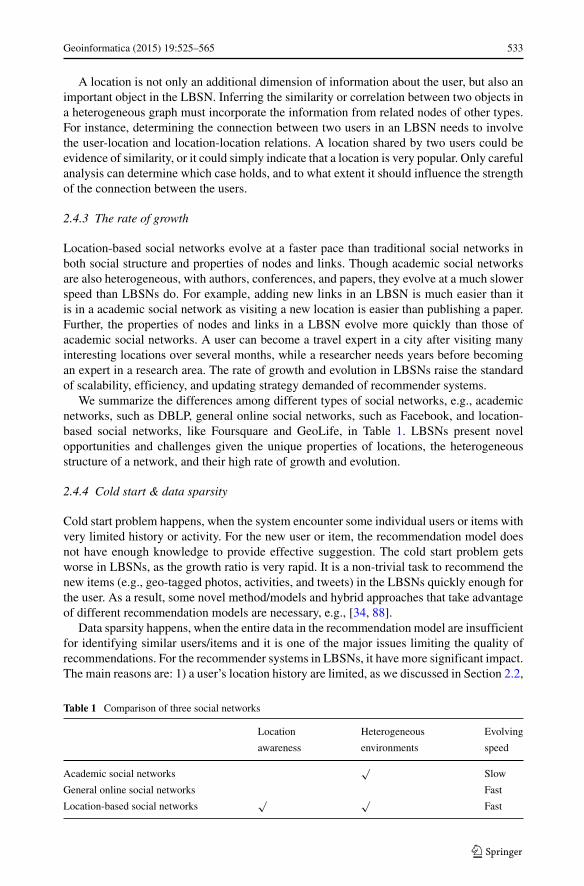
Location-based social networks evolve at a faster pace than traditional social networks inboth social structure and properties of nodes and links. Though academic social networksare also heterogeneous, with authors, conferences, and papers, they evolve at a much slowerspeed than LBSNs do. For example, adding new links in an LBSN is much easier than itis in a academic social network as visiting a new location is easier than publishing a paper.Further, the properties of nodes and links in a LBSN evolve more quickly than those ofacademic social networks. A user can become a travel expert in a city after visiting manyinteresting locations over several months, while a researcher needs years before becomingan expert in a research area. The rate of growth and evolution in LBSNs raise the standardof scalability, efficiency, and updating strategy demanded of recommender systems.
We summarize the differences among different types of social networks, e.g., academicnetworks, such as DBLP, general online social networks, such as Facebook, and location-based social networks, like Foursquare and GeoLife, in Table 1. LBSNs present novelopportunities and challenges given the unique properties of locations, the heterogeneousstructure of a network, and their high rate of growth and evolution.
2.4.4 Cold start & data sparsity
Cold start problem happens, when the system encounter some individual users or items withvery limited history or activity. For the new user or item, the recommendation model doesnot have enough knowledge to provide effective suggestion. The cold start problem getsworse in LBSNs, as the growth ratio is very rapid. It is a non-trivial task to recommend thenew items (e.g., geo-tagged photos, activities, and tweets) in the LBSNs quickly enough forthe user. As a result, some novel method/models and hybrid approaches that take advantageof different recommendation models are necessary, e.g., [34, 88].
Data sparsity happens, when the entire data in the recommendation model are insufficientfor identifying similar users/items and it is one of the major issues limiting the quality ofrecommendations. For the recommender systems in LBSNs, it have more significant impact.The main reasons are: 1) a user’s location history are limited, as we discussed in Section 2.2,
Table 1 Comparison of three social networks
Location Heterogeneous Evolving
awareness environments speed
Academic social networks√
Slow
General online social networks Fast
Location-based social networks√ √
Fast
534 Geoinformatica (2015) 19:525–565
while the number of places in a LBSN is a much larger number even in one city. In thiscase, the recommender system will generate a very sparse user-location model; and 2) auser’s location history is always locally crowded [73]. As a consequence, even if a user hasenough location history near her residential area, the recommender system will run into thedata sparsity issue, when she travels to some new areas.
2.5 Structure of the paper
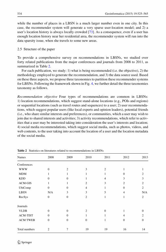
To provide a comprehensive survey on recommendations in LBSNs, we studied overforty related publications from the major conferences and journals from 2008 to 2011, assummarized in Table 2.
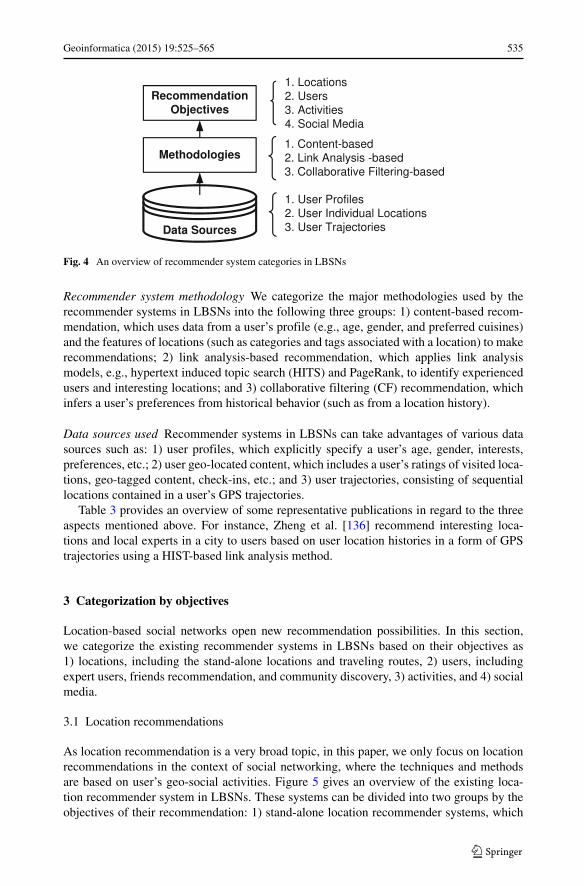
For each publication, we study: 1) what is being recommended (i.e. the objective), 2) themethodology employed to generate the recommendation, and 3) the data source used. Basedon these three aspects, we propose three taxonomies to partition these recommender systemsfor LBSNs. Following the framework shown in Fig. 4, we further detail the three taxonomiestaxonomy as follows.
Recommendation objective Four types of recommendations are common in LBSNs:1) location recommendations, which suggest stand-alone locations (e.g., POIs and regions)or sequential locations (such as travel routes and sequences) to a user; 2) user recommenda-tions, which suggest popular users (like local experts and opinion leaders), potential friends(i.e., who share similar interests and preferences), or communities, which a user may wish tojoin due to shared interests and activities; 3) activity recommendations, which refer to activ-ities that a user may be interested taking into consideration the user’s interests and location;4) social media recommendations, which suggest social media, such as photos, videos, andweb contents, to the user taking into account the location of a user and the location metadataof the social media.
Table 2 Statistics on literatures related to recommendations in LBSNs
Names 2008 2009 2010 2011 2012 2013
Conferences
WWW 0 2 3 2 1 1
MDM 1 1 1 1 0 2
KDD 0 0 1 4 3 3
ACM-GIS 1 1 2 3 2 2
UbiComp 0 0 4 1 0 2
LBSN N/A 3 3 5 4 N/A
RecSys 0 0 2 1 1 2
Journals
VLDB 0 0 2 0 1 0
ACM-TIST 0 0 1 1 4 2
ACM TWEB 0 0 0 1 0 0
Total numbers 2 7 19 19 16 14
Geoinformatica (2015) 19:525–565 535
Fig. 4 An overview of recommender system categories in LBSNs
Recommender system methodology We categorize the major methodologies used by therecommender systems in LBSNs into the following three groups: 1) content-based recom-mendation, which uses data from a user’s profile (e.g., age, gender, and preferred cuisines)and the features of locations (such as categories and tags associated with a location) to makerecommendations; 2) link analysis-based recommendation, which applies link analysismodels, e.g., hypertext induced topic search (HITS) and PageRank, to identify experiencedusers and interesting locations; and 3) collaborative filtering (CF) recommendation, whichinfers a user’s preferences from historical behavior (such as from a location history).
Data sources used Recommender systems in LBSNs can take advantages of various datasources such as: 1) user profiles, which explicitly specify a user’s age, gender, interests,preferences, etc.; 2) user geo-located content, which includes a user’s ratings of visited loca-tions, geo-tagged content, check-ins, etc.; and 3) user trajectories, consisting of sequentiallocations contained in a user’s GPS trajectories.
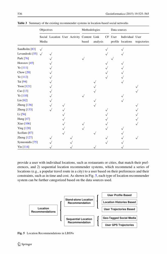
Table 3 provides an overview of some representative publications in regard to the threeaspects mentioned above. For instance, Zheng et al. [136] recommend interesting loca-tions and local experts in a city to users based on user location histories in a form of GPStrajectories using a HIST-based link analysis method.
3 Categorization by objectives
Location-based social networks open new recommendation possibilities. In this section,we categorize the existing recommender systems in LBSNs based on their objectives as1) locations, including the stand-alone locations and traveling routes, 2) users, includingexpert users, friends recommendation, and community discovery, 3) activities, and 4) socialmedia.
3.1 Location recommendations
As location recommendation is a very broad topic, in this paper, we only focus on locationrecommendations in the context of social networking, where the techniques and methodsare based on user’s geo-social activities. Figure 5 gives an overview of the existing loca-tion recommender system in LBSNs. These systems can be divided into two groups by theobjectives of their recommendation: 1) stand-alone location recommender systems, which
536 Geoinformatica (2015) 19:525–565
Table 3 Summary of the existing recommender systems in location-based social networks
Objectives Methodologies Data sources
Social Location User Activity Content Link CF User Individual User
Media based analysis profile locations trajectories
Sandholm [83]√ √ √
Levandoski [55]√ √ √ √
Park [76]√ √ √
Horozov [45]√ √ √
Ye [111]√ √ √
Chow [20]√ √ √
Ye [112]√ √ √
Tai [94]√ √ √
Yoon [121]√ √ √
Cao [13]√ √ √
Ye [110]√ √ √
Liu [62]√ √ √
Zheng [136]√ √ √ √
Zheng [133]√ √ √ √
Li [56]√ √ √
Hung [47]√ √ √
Xiao [106]√ √ √ √
Ying [120]√ √ √ √
Scellato [87]√ √ √
Zheng [127]√ √ √ √ √
Symeonidis [75]√ √ √ √
Yin [114]√ √ √ √
provide a user with individual locations, such as restaurants or cities, that match their pref-erences, and 2) sequential location recommender systems, which recommend a series oflocations (e.g., a popular travel route in a city) to a user based on their preferences and theirconstraints, such as in time and cost. As shown in Fig. 5, each type of location recommendersystem can be further categorized based on the data sources used.
Fig. 5 Location Recommendations in LBSNs
Geoinformatica (2015) 19:525–565 537
3.1.1 Stand-alone location recommendations
The stand-alone location recommender systems have been a focus of recent research,including the development of multiple prototype systems, e.g., [20, 76, 95, 111, 126, 127,132, 136]. We can further subdivide and categorize the stand-alone location recommendersystems based on the data sources used, as follows.
User profiles These location recommendation systems suggest locations by matching theuser’s profile against the location meta data, such as description and semantic text and tags.The first prototype of system proposed in [76] matches user’s profile data – including age,gender, cuisine preferences, and income – against the price and category of a restaurantusing a Bayesian network model. In [80], Ramaswamy et al., focus on enabling locationrecommendation on low-end devices capable only of voice and short text messages (SMS).Their approach focuses on using a user’s address and ’social affinity’, social connectionsimplied by a user’s address book, to make recommendations. The social affinity computa-tion and spatio-temporal matching techniques in the system are continuously tuned throughthe user feedback. In [52], Kodama et al., select location candidates using semantic dataand make a final recommendation using a skyline operator [9] that takes into account boththe price and the distance of the candidate locations. The advantage of this type of tech-nique is that, the recommendation will not suffer from the cold-start problem, where theusers or venues are new and have limited history. As long as the user or venue has a com-plete profile and category information, the recommendation can be done in an efficientway by matching the keywords and applying some filtering conditions. However, such sys-tems potentially suffer from the recommendation quality issue, because the system mayrecommend a matching place with poor quality from the social opinion.
User location histories A user’s location history includes a) their online rating historyof locations (e.g., hotels and restaurants) and b) their the check-in history in location-based social networking systems. Using users’ location histories, as described above, formaking recommendations has advantages over relying solely on profile data as locationhistories also capture the ratings from the other users. It therefore improves the qual-ity of recommendation by ignoring poorly-reviewed locations that otherwise match user’sprofile.
Many online web services, e.g. Yelp and Yellowpage, allow users to explicitly expresstheir preferences for locations using ratings. Using these ratings, a body of research,e.g., [20, 25, 45, 111], proposes location recommendation systems using CollaborativeFiltering (CF) models that give personalized recommendations for locations that takeinto account other users’ ratings. The intuition behind these methods is that a user willshare location preferences with similar users. Most of the CF-based location recommendersystems undertake three discrete operations, 1) similarity inference, which calculates a sim-ilarity score between users based on their historical ratings, 2) candidate selection, whichselects a subset of candidate locations using the user’s current location, and 3) recommen-dation score predication, which predicts the rating a user would give to a location. Forexample, motivated by the observation that “people who live in the same neighborhood arelikely to visit the same local places”, [45] uses the historical ratings from users living closeto the user’s query location, which significantly reduces the number of users in the user sim-ilarity matrix and thus reduces the computational cost of the recommendation. Similarly,Ye et al. 2010 [111] suggest that solely using the ratings of a user’s friends is more effi-cient and just as effective as using the ratings generated by the top-k most similar users.
538 Geoinformatica (2015) 19:525–565
The authors present a set of experiments showing that a user’s friends share more prefer-ences than strangers. Ye et al. 2011 [112], use user check-ins to study the effects of theCF-model, geographical distance, and social structures in making location recommenda-tions. The authors find that geographical distance has the largest impact in their model.In their following work [32], they extend the solution to consider the user’s social rela-tions and her current position. Zhang and Chow [125] further explore the geographicalinfluences in location recommendation, from the perspective of a user’s personalized travelpattern. In their model, each user in the system has a personalized travel distance pref-erences, which has the biggest impact on choosing the location recommendation. Theproposed technique achieves 40 % in precision and 25 % in recall, which are signifi-cantly superior than the conventional user-based collaborative filtering. In paper [119],the recommendation model extended by considering the general popularity of the can-didate venues by analyzing the large scale user check-in behavior. Shi et al. 2011 [89]propose a personalized location recommender system to take advantage of the venue cate-gory information using on a category-regularized matrix constructed from the user locationhistories. This type of location recommendations consider both the user’s preferences aswell as a category-based location similarity. Bao et al. [8] identify the the “new-city”recommendation issue, and propose a solution with three key components in a locationrecommender system, a) the user’s current location, which constrains the location candi-dates, b) the user’s location category histories, which reflects the user’s preferences, andc) the opinions from the local experts. Yin et al. 2013 [114] further extend the problemby proposing an LCA-LDA model, a location-content-aware probabilistic generative modelto quantify both the local preference and the item content information in the recommen-dation process. Yang et al. [108] also take advantage of the content information in theusers’ comments left in the check-ins to build a more fine-grained user preference modelfor personalized location ranking using tensor factorization techniques. In terms of improv-ing the efficiency of the location recommendations [20, 107], Chow et al., propose a newrecommendation algorithm that using the safe region technique to reduce the system com-municational and computational overhead for the users moving on their paths. In [25],Del Prete and Capra present a decentralized mobile recommendation service designed forpervasive environments using peer knowledge to avoid the bottleneck of the centralizedserver.
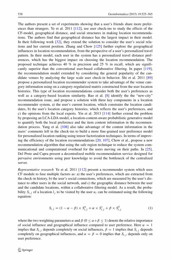
Representative research Ye et al. 2011 [112] present a recommender system which usesCF module to fuse multiple factors as: a) the user’s preferences, which are extracted fromthe check-in history, b) the user’s social connections, which are measured by the user’s dis-tance to other users in the social network, and c) the geographic distance between the userand the candidate locations, within a collaborative filtering model. As a result, the proba-bility Si,j of a location lj to be visited by the user ui can be estimated using the followingequation:
Si,j = (1 − α − β) × Sui,j + α × Ss
i,j + β × Sgi,j (1)
where the two weighting parameters α and β (0 ≤ α+β ≤ 1) denote the relative importanceof social influence and geographical influence compared to user preference. Here α = 1implies that Si,j depends completely on social influences, β = 1 implies that Si,j dependscompletely on geographical influences, and α = β = 0 implies that Si,j depends only onuser preference.
Geoinformatica (2015) 19:525–565 539
The authors explore the effect of the different factors in two large data sets fromFoursquare and Whrrl. They found their model allowed high precision and recall. Further,they observed that a) geographical influences had a greater impact on the probability of auser visiting a location than did social influences, b) Random Walk and Restart may notbe suitable for POI recommendations in LBSNs as close social network connections stillexhibit significantly different location preferences, and c) the insufficient number of visitorsto many locations limits some Collaborative Filtering approaches.
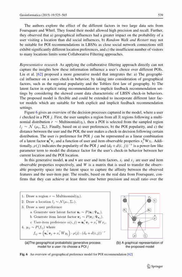
Representative research As applying the collaborative filtering approach directly can notcapture the insights how these information influence a user’s choice over different POIs.Liu et al. [62] proposed a more generative model that integrates the: a) The geographi-cal influence on a users check-in behavior, by taking into consideration of geographicalfactors, such as the regional popularity and the Toblers first law of geography. b) Thelatent factor in explicit rating recommendation to implicit feedback recommendation set-tings by considering the skewed count data characteristic of LBSN check-in behaviors.The proposed model is flexible and could be extended to incorporate different later fac-tor models which are suitable for both explicit and implicit feedback recommendationsettings.
Figure 6 gives an overview of the decision processes captured in the model, where a useri checked in a POI j . First, the user samples a region from all R regions following a multi-nomial distribution r ∼ Multinomial(ηi), then a POI is selected from the sampled regionlj ∼ N (μr, �r). Finally, based on a) user preferences, b) the POI popularity, and c) thedistance between the user and the POI, the user makes a check-in decision following certaindistribution. The user is preference for POI j can be represented as a linear combinationof a latent factor uᵀ
i vj and a function of user and item observable properties xᵀi Wyi . Addi-
tionally, ρ(j) indicates the popularity of the POI j and (d0 + d(i, j))−τ is a power-law likeparameter term to model the distance factor for the user’s check-in behavior between hercurrent location and the POI location.
In this generative model, u and v are user and item factors, xi and xj are user and itemobservable properties respectively, and W is a matrix that is used to transfer the observ-able prosperity space into the latent space to capture the affinity between the observedfeatures and the user-item pair. The results, based on the real data from Foursquare, con-firms that they can achieve at least three time better precision and recall ratio over the
(a) (b)
Fig. 6 An overview of geographical preference model for POI recommendation [62]
540 Geoinformatica (2015) 19:525–565
traditional single value decomposition (SVD), probabilistic matrix factorization(PMF),non-negative matrix factorization (NMF) and Bayesian non-negative matrix factorization(BMF) methods.
User trajectories Compared to stand-alone check-in data, user-generated trajectories con-tain a richer set of information, such as the visiting sequence between locations, the pathtraveled, and the duration of stay at each location. As a result, trajectory data can be usedto more accurately estimate a user’s preferences. Examples of recommender systems usingtrajectory data include [54, 58, 95, 135, 136]. In particular, Zheng, et al. [135, 136] proposea recommendation framework to find expert users and interesting locations by mining GPStrajectory data. In [13], Cao et al. extend the previous work to consider location-locationrelations as well as location-user relations. In [54], Leung et al. propose a dynamic cluster-ing algorithm in a collaborative location recommendation framework that takes advantageof user classes.
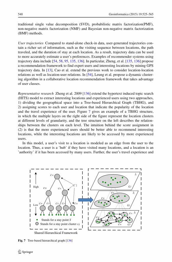
Representative research Zheng et al. 2009 [136] extend the hypertext induced topic search(HITS) model to extract interesting locations and experienced users using two approaches,1) dividing the geographical space into a Tree-based Hierarchical Graph (TBHG), and2) assigning scores to each user and location that indicate the popularity of the locationand the travel experience of the user. Figure 7 gives an example of a TBHG structure,in which the multiple layers on the right side of the figure represent the location clustersat different levels of granularity, and the tree structure on the left describes the relation-ships between the clusters on each level. The intuition behind the score assignment in(2) is that the more experienced users should be better able to recommend interestinglocations, while the interesting locations are likely to be accessed by more experiencedusers.
In this model, a user’s visit to a location is modeled as an edge from the user to thelocation. Thus, a user is a ’hub’ if they have visited many locations, and a location is an’authority’ if it has been accessed by many users. Further, the user’s travel experience and
Stands for a stay point SStands for a stay point cluster cij
{C }High
Low
Shared Hierarchical Framework
c10
c20 c21
c30 c31 c32 c33 c34
l1
G3
G1
G2
c30
c31
c32
c33
c34
c20
c21 l2
l3
Fig. 7 Tree-based hierarchical graph [136]
Geoinformatica (2015) 19:525–565 541
a location’s interest have a mutually reinforcing relationship. Based on this relationship, aranking of experienced users and interesting locations can be derived from the model usingthe following equations:
alij =
∑
uk∈U
vkjk × hk
lq (2)
hklq =
∑
cij ∈clq
vkij × al
ij (3)
where the subscripts ij implies that the quantity xij is of the ith level of the j th clusterin the TBHG, hk
ij represents the kth user’s experience, alij represents the location interest,
and clq is cij ’s parent node on the lth level. The rating is local, as the system rates userexperience and location interest at every level of the TBHG, which is consistent with theintuition, for example, that a very experienced user in New York may not have any idea ofthe interesting locations in Beijing. The authors use this model to extract the top n mostinteresting locations and the top k most experienced users in a given region using a poweriteration method. Based on the traveling trajectory from 108 users in GeoLife, the solutionachieves the score at 1.6/2, which is at least 20 % better than the ranking by count method,in a real user study.
3.1.2 Sequential location recommendations
Sequential location recommendations can have more complex objectives. For example, asuggested location path could maximize the number of interesting places visited while min-imizing travel time or energy consumption. From a user’s location history, one can inferhow a users preferences for locations are correlated [132]. A number of sequential locationrecommender systems have been proposed based on either users’ geo-tagged social mediaposts [58, 63, 65, 94, 102] and users’ GPS trajectories [15, 28, 35, 36, 121, 122, 133].
1) Mining Geo-tagged social media A user’s geo-tagged social media content can be usedas a knowledge base for making sequential location recommendations, e.g., as done in[4, 42]. In [94] the authors use association rule mining [2, 41] and sequence mining [40,93] over sequences of locations extracted from geo-tagged photos. Based on the user’shistorical visiting pattern, the system creates an itinerary of scenic locations to visit thatare popular among other users. Using a vast amount of geo-tagged photos collectedfrom Panoramio, the authors of [65] propose a Travel Route Suggestion algorithm tosuggest customized travel plans that take into account the time spent at each location,the total travel time, and user preferences. In [115], Yin et al. propose a trip recommen-dation method that focuses on ranking trajectory patterns mined from uploaded photos.In [58], the authors make use of users’ historical visiting patterns, including the type oflocation, to suggest subsequent locations.
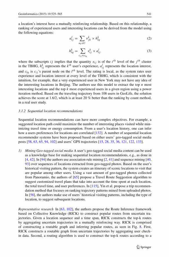
Representative research In [63, 102], the authors propose the Route Inference frameworkbased on Collective Knowledge (RICK) to construct popular routes from uncertain tra-jectories. Given a location sequence and a time span, RICK constructs the top-k routesby aggregating uncertain trajectories in a mutually reinforcing way. RICK is comprisedof constructing a routable graph and inferring popular routes, as seen in Fig. 8. First,RICK constructs a routable graph from uncertain trajectories by aggregating user check-in data. Second, a routing algorithm is used to construct the top-k routes according to a
542 Geoinformatica (2015) 19:525–565
Fig. 8 Construct popular routes [63, 102]
user-specified query. The proposed routable graph provides a good model of the uncer-tain trajectory with an accuracy of 0.9. Also, on average, the system can find the top-3routes within 0.5 seconds, with a distance error smaller than 300 meters compared to itscorresponding ground-truth.
2) Mining GPS trajectoryGPS trajectories contain a rich set of information, including the duration a user
spent at a location and the order of location visits, that can improve sequential loca-tion recommendations. In [28], the authors present a graph model for socio-spatialnetworks that stores information about frequently traveled routes and implement aroute recommender system using their query language. In [15], the authors proposea route recommender system that takes into account a user’s own historically pre-ferred road segments, mined from the user’s historical trajectories. The intuition forthis approach is that users may feel more comfortable traveling on familiar roads. In[35], Ge et al 2011. propose an approach to travel recommendation based on the user’scost constraints, where the travel costs are learned using tour data from professionaltravel agencies. In [36], Ge et al. 2010 integrate energy consumption into a mobilerecommender system by learning energy-efficient transportation patterns from trajec-tories. In [43], the system integrates the real-time information updates from the localcommunity to recommend a better route to avoid the traffic.
Representative research The itinerary recommender system [121, 122, 133] furtherextended the previous works by incorporating additional constraints, such as 1) a total timeconstraint on the trip, e.g., a user only has 8 hours for traveling, 2) a destination constraint,which indicates that the user wants to end the trip with a selected location, e.g. a user mayneed to return to a hotel or the airport, and 3) a constraint on specific ratio metrics, includ-ing a) the elapsed time ratio (ETR) between the duration of the recommended trip to thetotal time constraint, which captures a user’s desire to utilize as much available time aspossible, b) the stay time ratio (STR) between the amount of time a user stays at locationto the amount of time spent traveling between locations, which captures a user’s desire to
Geoinformatica (2015) 19:525–565 543
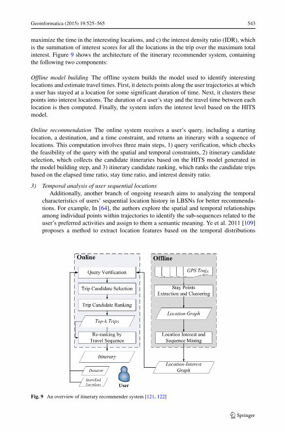
maximize the time in the interesting locations, and c) the interest density ratio (IDR), whichis the summation of interest scores for all the locations in the trip over the maximum totalinterest. Figure 9 shows the architecture of the itinerary recommender system, containingthe following two components:
Offline model building The offline system builds the model used to identify interestinglocations and estimate travel times. First, it detects points along the user trajectories at whicha user has stayed at a location for some significant duration of time. Next, it clusters thesepoints into interest locations. The duration of a user’s stay and the travel time between eachlocation is then computed. Finally, the system infers the interest level based on the HITSmodel.
Online recommendation The online system receives a user’s query, including a startinglocation, a destination, and a time constraint, and returns an itinerary with a sequence oflocations. This computation involves three main steps, 1) query verification, which checksthe feasibility of the query with the spatial and temporal constraints, 2) itinerary candidateselection, which collects the candidate itineraries based on the HITS model generated inthe model building step, and 3) itinerary candidate ranking, which ranks the candidate tripsbased on the elapsed time ratio, stay time ratio, and interest density ratio.
3) Temporal analysis of user sequential locationsAdditionally, another branch of ongoing research aims to analyzing the temporal
characteristics of users’ sequential location history in LBSNs for better recommenda-tions. For example, In [64], the authors explore the spatial and temporal relationshipsamong individual points within trajectories to identify the sub-sequences related to theuser’s preferred activities and assign to them a semantic meaning. Ye et al. 2011 [109]proposes a method to extract location features based on the temporal distributions
Fig. 9 An overview of itinerary recommender system [121, 122]
544 Geoinformatica (2015) 19:525–565
of users’ check-ins. Ye et al. [110] extends their work by considering two additionalaspects, 1) a set of explicit patterns, including the total number of check-ins, the totalnumber of unique visitors, the maximum number of check-ins by a single visitor, thedistribution of check-in times in a week, and the distribution of check-in times in a24-hour interval, and 2) implicit relatedness, which captures the correlations betweenlocations in check-in behavior. Based on the temporal characteristics of users’ check-in behaviors, recommender systems in LBSNs now recommend locations based onthe current time. For example, Cho et al. [19] propose a location recommendationmethod based on the periodicity of the human movement. They propose two methodsPMM (Periodic Mobility Model) and PSMM (Periodic Social Mobility Model) using atemporal probability distribution function and the social relations. Gao et al. [33] fur-ther extends the model with using more aggregated temporal functions, such as sum,mean, maximum and voting, over the users’ check-in data. Most recently, Rahimi andWang [79] further extend the existing work by studying the spatial and temporal peri-odicity activities in the users’ check-in data, and propose two novel recommendationalgorithms, Probabilistic Category Recommender, which uses the temporal probabil-ity distribution to recommend the category of location that would be interested for theuser based on her historical behavior, and Probabilistic Category-based Recommender,which further considers the user’s spatial traveling behaviors. The experimental resultsshow that they can achieve over 15 % improvement in both recall and precisionevaluations.
Representative research Cho et al. [19] analyzed a large scale user check-in dataset fromBrightKite and Gowalla, where they find that humans experience a combination of periodicmovement affected by both the geographical location and the social relations. More specif-ically, their short-ranged travel is periodic both spatially and temporally and not effectedby the social network structure, while long-distance travel is more influenced by social net-work ties. The data reveals that social relationships can explain about 10 % to 30 % of allhuman movement, while periodic behavior explains 50 % to 70 %.
Based on the insights, they propose two methods PMM (Periodic Mobility Model) andPSMM (Periodic Social Mobility Model) to predict/recommend the user’s locations. InPMM model, the authors define a limited number of states for the user that has periodicityactivities, like home or work. Based on the different time of the day, they build a temporalcomponent of PMM model as:
P [cu] = H ] = NH (t)
NH (t) + NW (t)(4)
P [cu] = W ] = NW (t)
NH (t) + NW (t)(5)
where P [cu(t)] models the probability distribution over the state of the user over time andNW (t) and NH (t) are with a truncated Gaussian distribution parameterized by the time ofthe day.
The spatial component is generated by modeling the movement when a user is in thehome/work state using a 2-dimensional time-independent Gaussian distribution:
P [xu(t) = xi |cu(t)] ={
N (μH ,�H ) if cut = H
N (μW ,�W ) if cut = W(6)
Geoinformatica (2015) 19:525–565 545
where �H , �w are the home, work check-in position co-variance matrices. μH and μH arethe means of users check-in locations hen she is in home and work state, respectively.
PMMS model further improves the previous model by adding the factor from the user’ssocial relations. To include the social network information to the model, we introduceanother check-in classification zu(t), where zu(t) = 1 implies the check-in is social (non-periodic) and zu(t) = 0 implies that it is periodic. The PSMM mobility model thenbecomes:
Pu[x(t) = x] = P [x(t) = x|zu(t) = 1] · P [zu(t) = 1]+ P [x(t) = x|zu(t) = 0] · P [zu(t) = 0] (7)
where P [x(t) = x|zu(t) = 0] is the Periodic Mobility Model.
3.2 User recommendations
User recommendations, which includes popular user discovery [12, 38, 98], friend recom-mendation [5, 16, 82, 104, 117], and community discovery [60, 103], have been extensivelystudied in the context of traditional social networks. The traditional user recommenda-tion approaches are based on the underlying social structure and user interaction patterns.Location-based social networks provide a new way to make user recommendations by alsoconsidering users’ location histories. Location histories provide rich contextual informa-tion and have significant correlations to real social behaviors [22]. Several studies revealthat geographical information actually plays a vital role in determining user relationshipswithin social networks. For example, by analyzing the spatial dissemination of new babynames, [39] confirms the importance of geographical proximity, despite the interconnect-edness of the Internet era. Liben-Nowell [59] shows that at least 2/3 of the friendshipsin an online social network are determined by the users’ locations. Scellato [86] analyzesthe data collected from a location-based social networking system (Foursquare) and findsthat 1) about 40 % of the connections are within 100 km, 2) a strong heterogeneity existsacross users regarding the spatial distances of connections between their social ties and tri-ads, and 3) gravity models may influence how these social connections are created. Thus,considering users’ location histories in an LBSN can improve the effectiveness and effi-ciency of user recommendations. In this section, we summarize the existing work in userrecommendation for location-based social networks, e.g., [48, 56, 105, 118, 120, 136], cat-egorizing each work by its objective, 1) popular user discovery, 2) friend recommendation,or 3) community discovery.
Popular user discovery Traditional approaches to popular user discovery [12, 98] find theopinion leaders in a social networking service by analyzing the node degrees within theinformation diffusion networks. In LBSNs, we consider ’popular users’ to be the users withmore knowledge about the locations. Finding experienced users is very important for therecommender systems in LBSNs as these users can provide high quality location recom-mendations. Zheng et al. 2009 [136] finds that a user’s traveling experiences are regional,and a user’s experience is best determined by considering the qualities of the locations inaddition to the number of locations visited. The authors propose a system to identify experi-enced travelers by applying a HITS inference model over a Tree-Based Hierarchical Graphof users’ historical trajectories. Ying et al. 2011 [118] extends the previous work and pro-poses four metrics that are used for analysis on EveryTrail (a website for sharing trips).They found that users who share more trajectories get more attention from other users, andusers who are popular are more likely to connect to other popular users.
546 Geoinformatica (2015) 19:525–565
Friend recommendation Traditional friend recommender systems provide a user withpromising potential friends based on their user profiles [16, 104], the social structure [27],and the users’ interactions [5, 38, 82]. Location information in can significantly improve theeffectiveness of friend recommendations. The basic intuition is that user location historiesreveal preferences, and thus users with similar location histories have similar preferencesand are more likely to become friends. Several publications investigate the impact of users’geographical locations on their social relations. For example, a recent study [26] on MyS-pace data reveals that users’ social connections are highly related to their geographicaldistances, i.e. that the users living close to each other are more likely to be friends. More-over, Backstrom et al. [6] observe that at medium to long-range distances, the probability offriendship is roughly proportional to the inverse of the distance. However, at shorter ranges,distance does not play as large a role in determining the likelihood of friendships. Similarly,Scellato et al. 2011 [87] analyze a large set of data from Gowalla (a location-based socialnetworking system), from which they find that the link prediction space can be reduced by15 times by focusing on location-friends and friends-of-friends. Based on this observation,they propose a link predication model using supervised learning that considers the users’visited locations. Yu et al. [123] builds a pattern-based heterogeneous information networkto predict connection probabilities using an unsupervised link analysis model. The connec-tions inside the information network reflect users’ geographical histories as well as theirsocial relationships. The connection probability and the friend recommendation score arecalculated by a random walk process over the user-location network. Other works, suchas [19], study the relationship between user movement and friendships through an analy-sis of mobile phone communications and check-ins. The authors discover that users’ shortterm periodical movement is irrelevant to social structure, but their long distance movementsignificantly affects their social structure.
A related body of research proposes to measure the similarity between two users fromtheir historical locations and trajectories. Li et al. 2008 [56] present a user similarity algo-rithm that builds a tree-based hierarchical graph of locations. A user’s detailed trajectory isabstracted as a set of sequentially visited locations. Based on a sequence matching algorithmthat takes into account location hierarchies, the system finds users with similar travelingpatterns. Xiao et al. [105] extend the user similarity approach by considering the availablesemantic information for each location, such as its tags and categories. This allows connec-tions between users who have different geographic behaviors, e.g., living in different cities,but share similar semantic behaviors, i.e. they go to the same types of locations. For thisapproach, the authors transform users’ trajectories int location histories with category infor-mation. Similarity scores between users are calculated by matching their maximal travelingsequences at different spatial granularities. Ye et al. 2010 [120] expand on the use of locationsemantic information. Their framework consists of four phases, 1) semantic trajectory trans-formation, which converts a user trajectory into a sequence of locations with semantic data,such as parks and schools; 2) maximum semantic trajectory pattern mining, which appliesthe sequential pattern mining algorithm to each user’s trajectory to find the most frequentsequence, 3) semantic similarity measurement, which computes a similarity score betweenusers maximum semantic trajectories, and 4) potential friend recommendation, which usesthe constructed user similarity matrix to suggest potential friends.
Representative research Zheng et al. 2011 [134] further extends the user similarity mea-sure framework presented in [56] by considering the sequences of locations at differentspatial granularities. The authors propose a new sequence matching algorithm that dividesthe location sequences and considers the popularity of each visited locations separately. The
Geoinformatica (2015) 19:525–565 547
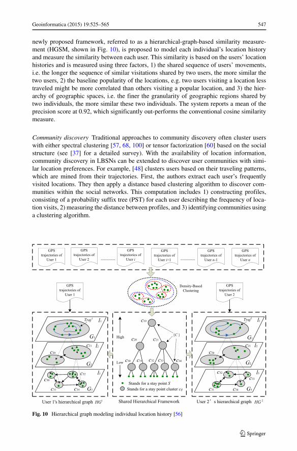
newly proposed framework, referred to as a hierarchical-graph-based similarity measure-ment (HGSM, shown in Fig. 10), is proposed to model each individual’s location historyand measure the similarity between each user. This similarity is based on the users’ locationhistories and is measured using three factors, 1) the shared sequence of users’ movements,i.e. the longer the sequence of similar visitations shared by two users, the more similar thetwo users, 2) the baseline popularity of the locations, e.g. two users visiting a location lesstraveled might be more correlated than others visiting a popular location, and 3) the hier-archy of geographic spaces, i.e. the finer the granularity of geographic regions shared bytwo individuals, the more similar these two individuals. The system reports a mean of theprecision score at 0.92, which significantly out-performs the conventional cosine similaritymeasure.
Community discovery Traditional approaches to community discovery often cluster userswith either spectral clustering [57, 68, 100] or tensor factorization [60] based on the socialstructure (see [37] for a detailed survey). With the availability of location information,community discovery in LBSNs can be extended to discover user communities with simi-lar location preferences. For example, [48] clusters users based on their traveling patterns,which are mined from their trajectories. First, the authors extract each user’s frequentlyvisited locations. They then apply a distance based clustering algorithm to discover com-munities within the social networks. This computation includes 1) constructing profiles,consisting of a probability suffix tree (PST) for each user describing the frequency of loca-tion visits, 2) measuring the distance between profiles, and 3) identifying communities usinga clustering algorithm.
Fig. 10 Hierarchical graph modeling individual location history [56]
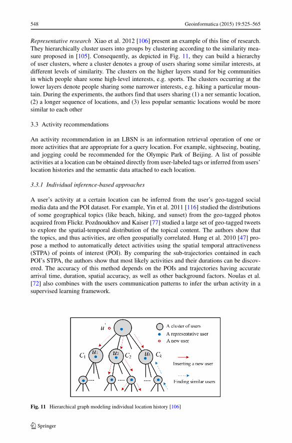
548 Geoinformatica (2015) 19:525–565
Representative research Xiao et al. 2012 [106] present an example of this line of research.They hierarchically cluster users into groups by clustering according to the similarity mea-sure proposed in [105]. Consequently, as depicted in Fig. 11, they can build a hierarchyof user clusters, where a cluster denotes a group of users sharing some similar interests, atdifferent levels of similarity. The clusters on the higher layers stand for big communitiesin which people share some high-level interests, e.g. sports. The clusters occurring at thelower layers denote people sharing some narrower interests, e.g. hiking a particular moun-tain. During the experiments, the authors find that users sharing (1) a ner semantic location,(2) a longer sequence of locations, and (3) less popular semantic locations would be moresimilar to each other
3.3 Activity recommendations
An activity recommendation in an LBSN is an information retrieval operation of one ormore activities that are appropriate for a query location. For example, sightseeing, boating,and jogging could be recommended for the Olympic Park of Beijing. A list of possibleactivities at a location can be obtained directly from user-labeled tags or inferred from users’location histories and the semantic data attached to each location.
3.3.1 Individual inference-based approaches
A user’s activity at a certain location can be inferred from the user’s geo-tagged socialmedia data and the POI dataset. For example, Yin et al. 2011 [116] studied the distributionsof some geographical topics (like beach, hiking, and sunset) from the geo-tagged photosacquired from Flickr. Pozdnoukhov and Kaiser [77] studied a large set of geo-tagged tweetsto explore the spatial-temporal distribution of the topical content. The authors show thatthe topics, and thus activities, are often geospatially correlated. Hung et al. 2010 [47] pro-pose a method to automatically detect activities using the spatial temporal attractiveness(STPA) of points of interest (POI). By comparing the sub-trajectories contained in eachPOI’s STPA, the authors show that most likely activities and their durations can be discov-ered. The accuracy of this method depends on the POIs and trajectories having accuratearrival time, duration, spatial accuracy, as well as other background factors. Noulas et al.[72] also combines with the users communication patterns to infer the urban activity in asupervised learning framework.
Fig. 11 Hierarchical graph modeling individual location history [106]
Geoinformatica (2015) 19:525–565 549
3.3.2 Collaborative learning-based approaches
One shortcoming of individual inference-based approaches is that they have difficulty deal-ing with data sparsity, which can be a common occurrence in LBSNs as some users mayhave a limited location history and some locations may receive few visitors. An alterna-tive approach based on collaborative learning uses information from all users to discoveractivities. This idea was first proposed in [129], which extracts the location semantics fromGPS data and uses it in conjunction with user profile data to identify activities. The sys-tem exploits the connections between the user activities and profiles in a joint learningprocess. Further, Zheng et al. 2010 [127] propose a new model for location and activ-ity histories using a user-location-activity rating tensor. Their system uses this model toprovide location-specific activity recommendations. Zheng et al. [128] proposes a new algo-rithm that uses a ranking-based collective tensor and matrix factorization model. Separately,[75] extends the previous work by using the Higher Order Singular Value Decomposition(HOSVD) technique to perform dimensionality reduction and semantic analysis. As moredata is accumulated by their system, it uses incremental solutions to update a tensor thatincludes users, locations and activities.
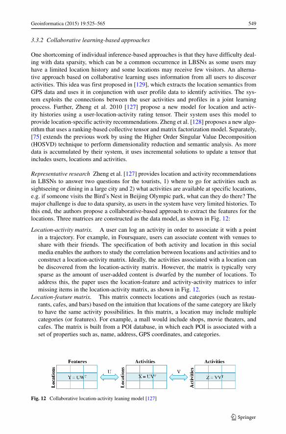
Representative research Zheng et al. [127] provides location and activity recommendationsin LBSNs to answer two questions for the tourists, 1) where to go for activities such assightseeing or dining in a large city and 2) what activities are available at specific locations,e.g. if someone visits the Bird’s Nest in Beijing Olympic park, what can they do there? Themajor challenge is due to data sparsity, as users in the system have very limited histories. Tothis end, the authors propose a collaborative-based approach to extract the features for thelocations. Three matrices are constructed as the data model, as shown in Fig. 12:
Location-activity matrix. A user can log an activity in order to associate it with a pointin a trajectory. For example, in Foursquare, users can associate content with venues toshare with their friends. The specification of both activity and location in this socialmedia enables the authors to study the correlation between locations and activities and toconstruct a location-activity matrix. Ideally, the activities associated with a location canbe discovered from the location-activity matrix. However, the matrix is typically verysparse as the amount of user-added content is dwarfed by the number of locations. Toaddress this, the paper uses the location-feature and activity-activity matrices to infermissing items in the location-activity matrix, as shown in Fig. 12.
Location-feature matrix. This matrix connects locations and categories (such as restau-rants, cafes, and bars) based on the intuition that locations of the same category are likelyto have the same activity possibilities. In this matrix, a location may include multiplecategories (or features). For example, a mall would include shops, movie theaters, andcafes. The matrix is built from a POI database, in which each POI is associated with aset of properties such as, name, address, GPS coordinates, and categories.
Fig. 12 Collaborative location-activity leaning model [127]
550 Geoinformatica (2015) 19:525–565
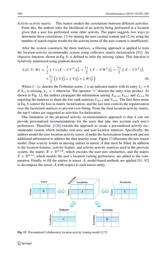
Activity-activity matrix. This matrix models the correlations between different activities.From this, the authors infer the likelihood of an activity being performed at a locationgiven that a user has performed some other activity. The paper suggests two ways todetermine these correlations, (1) by mining the user-created content and (2) by using thenumber of search engine results for the activity terms (if the user-content is insufficient).
After the system constructs the three matrices, a filtering approach is applied to trainthe location-activity recommender system using collective matrix factorization [91]. Anobjective function, shown in Eq. 8, is defined to infer the missing values. This function isiteratively minimized using gradient descent.
L(U, V,W) = 1
2‖ I ◦ (X − UV T )‖2
F + λ1
2‖ Y − UWT ‖2
F + λ2
2‖ Z − V V T ‖2
F
+λ3
2
(‖ U‖2
F + ‖ V ‖2F + ‖ W‖2
F
)(8)
Where ‖ · ‖F denotes the Frobenius norm. I is an indicator matrix with its entry Iij = 0if Xij is missing, Iij = 1 otherwise. The operator “◦” denotes the entry-wise product. Asshown in Fig. 12, the authors propagate the information among Xm×n, Ym×l and Zn×n byrequiring the matrices to share the low-rank matrices Um×k and Vn×k . The first three termsin Eq. 8 control the loss in matrix factorization, and the last term controls the regularizationover the factorized matrices to prevent over-fitting. From the final location-activity matrix,the top k values are suggested as activities for thelocation.
One limitation of the proposed activity recommendation approach is that it can notprovide personalized recommendations for the users that take into account each user’spreferences. Therefore, [126] extends the approach to create a personalized activity rec-ommender system which includes user-user and user-location matrices. Specifically, theauthors model the user-location-activity tensor A under the factorization framework and useadditional information to address the data sparsity issue. Figure 13 illustrates the new tensormodel. Data scarcity results in missing entries in tensor A that must be filled. In additionto the location-features, activity-feature, and activity-activity matrices used in the previoussystem, the matrix B ∈ R
m×m, which encodes the user-user similarities, and the matrixE ∈ R
m×n, which models the user’s location visiting preferences, are added to the com-putation. Finally, to fill the entries in tensor A, model-based methods are applied [91, 92]to decompose the tensor A with respect to each tensor entity.
Fig. 13 Personalized Collaborative location-activity leaning model [127]
Geoinformatica (2015) 19:525–565 551
3.4 Social media recommendations
Social media recommendation aims to provide users with suggestions of photos, videos,or other web content they might like. Using location information in LBSNs can improveboth the effectiveness and efficiency of traditional social media recommendations. Severalworks in spatial keyword searching for web content show the effectiveness of this pairing,e.g., [10, 17, 84, 124].
Mokbel et al. [69] analyzes the rating data from MovieLens [70] and finds that people atdifferent locations have different preferences. For example, users from Minnesota are moreinterested in crime and war movies, while users from Florida are more interested in fantasyand animation movies. Location-aware image ranking algorithms have been proposed toincrease the relevance of the search results, e.g., [3, 50]. Silva and Martins [90] improves thequality of the image tags using a recommender system to automatically infer and suggestcandidate location tags. Daly and Geyer [23] discovers events using both social and locationinformation. Hu and Ester [46] propose a topic model that considering the spatial and textualaspects of the user’s post and build a spatial topic model to capture the relation between theuser’s location and interests.
The efficiency of recommender systems can be significantly improved by using loca-tion data to prune out irrelevant information. Scellato et al. [85] improves the efficiencyof content delivery networks using a novel caching mechanism based on geographiclocation. Sandholm and Ung [83] builds a real-time recommender system for onlineweb content using a collaborative filtering method to make more diverse and person-alized recommendations within a geographical area. Levandoski et al. [55] proposes anovel location-aware recommendation framework, LARS, which considers the influencesof the spatial ratings and spatial users in the location-aware recommendations. In [84],the authors further extend the viral marketing model in a location-based social network,where they consider the user opinion, spatial distance and the social influences to rec-ommend a best set of customers to the venue owners that may maximize the potentialprofit.
4 Categorization by methodology
Although traditional recommendation systems have been successful by using communityopinions, e.g., inventories in Amazon [61] and news from Google [24], incorporatinglocation information requires novel approaches. In this section, we categorize the majormethodologies used by recommendation systems in location-based social networks as beingbased on: 1) content, 2) link analysis, or 3) collaborative filtering.
4.1 Content-based recommendations
Content-based recommendation systems, such as [76, 80], match user preferences, discov-ered from users’ profiles, with features extracted from locations, such as tags and categories,to make recommendations. These systems require accurate and structured information forboth the user profiles and the location features to make high quality recommendations.
The major advantages of the content-based approach that such a system is robust againstthe cold start problem for both new users and locations. As long as the newly added useror location has the appropriate descriptive content, they can be handled effectively. How-ever, content-based recommendation systems have many drawbacks in regard to LBSNs:
552 Geoinformatica (2015) 19:525–565
1) content-based recommendation systems do not consider the aggregated communityopinions (inferred from users), which may result low quality recommendations, and 2)content-based recommendation systems require that the structured information for bothusers and locations be created and maintained, which can be costly, especially in LBSNsin which the majority of the contents (i.e., user profiles and location tags) are generated bythe users.
4.2 Link analysis-based recommendations
Link analysis algorithms, e.g., PageRank [74] and Hypertext Induced Topic Search(HITS) [14, 51], are widely used to rank the web pages. These algorithms extract highquality nodes from a complex network by analyzing the structure. In LBSNs, there are inter-connected networks of different types, e.g., user-user, user-location, and location-locationnetworks. Zheng et al. [136] extends the HITS algorithm for discovering experienced usersand interesting locations in an LBSN. In their system, each location is assigned a popularityscore, and each user is assigned a hub score, which indicates their travel expertise. Basedon a mutually reinforcing relationship, a ranking of expert users and interesting locations iscomputed. Similarly, [81] extends a random walk-based link analysis algorithm to providelocation recommendation.
The advantages of link analysis-based methodologies are that 1) they take into accountthe user’s experiences when making recommendations and amplify ratings from experi-enced users, and 2) they are robust against the cold start problem. However, they havea major drawback: they can only provide generic recommendations for all users, whichoverlooks users’ personal preferences.
4.3 Collaborative filtering-based recommendations
Collaborative filtering (CF) is widely used in conventional recommendation systems [1].The intuition in extending the CF model for recommendations in LBSNs is that a user ismore likely to visit a location if it is preferred by similar users. The CF approach usedby recommender systems in LBSNs consists of three processes: 1) candidate selection,2) similarity inference, and 3) recommendation score predication.
Candidate selections The first step of CF-based recommendation systems is to select asubset of candidate nodes to reduce the computational overhead. The traditional CF-basedrecommendation algorithms use the most similar users (or locations, activities, etc.) as thecandidates. CF-based recommender systems in LBSNs can also use geographic bounds andassociations to constrain the candidate selection process. A spatial range can be computed toprune candidate locations, e.g., [20]. Horozov et al. [45] selects candidate users by consid-ering only individuals who live near the user’s querying location. Non-geographic criteriacan also be used. In [111], the authors select candidates by considering user preferenceand social influence, but also geographic influence modeled as a power-law probabilisticmodel.
Similarity inferences Similarities between users (or locations, activities, etc.) are inferredfrom users’ ratings and location histories in LBSNs. The traditional CF models can bedivided into two subgroups: 1) user-based models, such as [44], that use similarity measuresbetween each pair of users; and 2) item-based models, such as [53], that use similarity mea-sures between each pair of items (media content, activities, etc.). The following equation
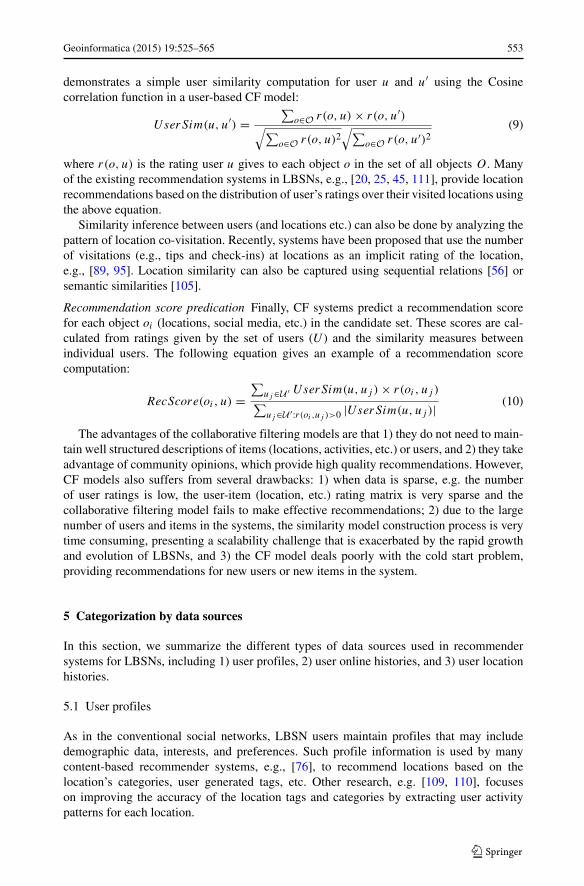
Geoinformatica (2015) 19:525–565 553
demonstrates a simple user similarity computation for user u and u′ using the Cosinecorrelation function in a user-based CF model:
UserSim(u, u′) =∑
o∈O r(o, u) × r(o, u′)√∑
o∈O r(o, u)2√∑
o∈O r(o, u′)2(9)
where r(o, u) is the rating user u gives to each object o in the set of all objects O. Manyof the existing recommendation systems in LBSNs, e.g., [20, 25, 45, 111], provide locationrecommendations based on the distribution of user’s ratings over their visited locations usingthe above equation.
Similarity inference between users (and locations etc.) can also be done by analyzing thepattern of location co-visitation. Recently, systems have been proposed that use the numberof visitations (e.g., tips and check-ins) at locations as an implicit rating of the location,e.g., [89, 95]. Location similarity can also be captured using sequential relations [56] orsemantic similarities [105].
Recommendation score predication Finally, CF systems predict a recommendation scorefor each object oi (locations, social media, etc.) in the candidate set. These scores are cal-culated from ratings given by the set of users (U ) and the similarity measures betweenindividual users. The following equation gives an example of a recommendation scorecomputation:
RecScore(oi, u) =∑
uj ∈U ′ UserSim(u, uj ) × r(oi, uj )∑
uj ∈U ′:r(oi ,uj )>0 |UserSim(u, uj )| (10)
The advantages of the collaborative filtering models are that 1) they do not need to main-tain well structured descriptions of items (locations, activities, etc.) or users, and 2) they takeadvantage of community opinions, which provide high quality recommendations. However,CF models also suffers from several drawbacks: 1) when data is sparse, e.g. the numberof user ratings is low, the user-item (location, etc.) rating matrix is very sparse and thecollaborative filtering model fails to make effective recommendations; 2) due to the largenumber of users and items in the systems, the similarity model construction process is verytime consuming, presenting a scalability challenge that is exacerbated by the rapid growthand evolution of LBSNs, and 3) the CF model deals poorly with the cold start problem,providing recommendations for new users or new items in the system.
5 Categorization by data sources
In this section, we summarize the different types of data sources used in recommendersystems for LBSNs, including 1) user profiles, 2) user online histories, and 3) user locationhistories.
5.1 User profiles
As in the conventional social networks, LBSN users maintain profiles that may includedemographic data, interests, and preferences. Such profile information is used by manycontent-based recommender systems, e.g., [76], to recommend locations based on thelocation’s categories, user generated tags, etc. Other research, e.g. [109, 110], focuseson improving the accuracy of the location tags and categories by extracting user activitypatterns for each location.
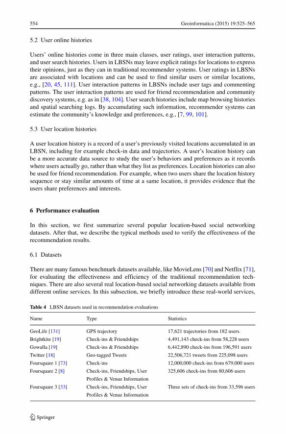
554 Geoinformatica (2015) 19:525–565
5.2 User online histories
Users’ online histories come in three main classes, user ratings, user interaction patterns,and user search histories. Users in LBSNs may leave explicit ratings for locations to expresstheir opinions, just as they can in traditional recommender systems. User ratings in LBSNsare associated with locations and can be used to find similar users or similar locations,e.g., [20, 45, 111]. User interaction patterns in LBSNs include user tags and commentingpatterns. The user interaction patterns are used for friend recommendation and communitydiscovery systems, e.g. as in [38, 104]. User search histories include map browsing historiesand spatial searching logs. By accumulating such information, recommender systems canestimate the community’s knowledge and preferences, e.g., [7, 99, 101].
5.3 User location histories
A user location history is a record of a user’s previously visited locations accumulated in anLBSN, including for example check-in data and trajectories. A user’s location history canbe a more accurate data source to study the user’s behaviors and preferences as it recordswhere users actually go, rather than what they list as preferences. Location histories can alsobe used for friend recommendation. For example, when two users share the location historysequence or stay similar amounts of time at a same location, it provides evidence that theusers share preferences and interests.
6 Performance evaluation
In this section, we first summarize several popular location-based social networkingdatasets. After that, we describe the typical methods used to verify the effectiveness of therecommendation results.
6.1 Datasets
There are many famous benchmark datasets available, like MovieLens [70] and Netflix [71],for evaluating the effectiveness and efficiency of the traditional recommendation tech-niques. There are also several real location-based social networking datasets available fromdifferent online services. In this subsection, we briefly introduce these real-world services,
Table 4 LBSN datasets used in recommendation evaluations
Name Type Statistics
GeoLife [131] GPS trajectory 17,621 trajectories from 182 users.
Brightkite [19] Check-ins & Friendships 4,491,143 check-ins from 58,228 users
Gowalla [19] Check-ins & Friendships 6,442,890 check-ins from 196,591 users
Twitter [18] Geo-tagged Tweets 22,506,721 tweets from 225,098 users
Foursquare 1 [73] Check-ins 12,000,000 check-ins from 679,000 users
Foursquare 2 [8] Check-ins, Friendships, User 325,606 check-ins from 80,606 users
Profiles & Venue Information
Foursquare 3 [33] Check-ins, Friendships, User Three sets of check-ins from 33,596 users
Profiles & Venue Information
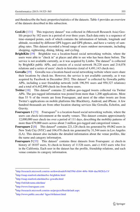
Geoinformatica (2015) 19:525–565 555
and thendescribe the basic properties/statistics of the datasets. Table 4 provides an overviewof the datasets described in this subsection.
GeoLife [131] This trajectory dataset1 was collected in (Microsoft Research Asia) Geo-life project by 182 users in a period of over three years. Each data entry is a sequence oftime-stamped points, each of which contains the information of latitude, longitude andaltitude, recorded by different GPS loggers and GPS-phones, and have a variety of sam-pling rates. This dataset recorded a broad range of users outdoor movements, includingshopping, sightseeing, dining, hiking, and cycling.
BrightKite [19] Brightkite was a location-based social networking website, where theusers were able to ”check in” at places and able to see who has been there before. Theservice is not available currently, as it was acquired by Limbo. The dataset2 is collectedby BrightKit public APIs, and consists of a social network 58,228 users and 214,078relations and a series of users’ check-in histories (total of 4,491,143 check-ins).
Gowalla [19] Gowalla was a location-based social networking website where users sharetheir locations by check-ins. However, the service is not available currently, as it wasacquired by Facebook in December 2012. This dataset3 is collected by Gowalla publicAPIs, including a user friendship network (with 196,591 users and 950,327 relations)and a total of 6,442,890 check-ins from these users.
Twitter [18] This dataset4 contains 22 million geo-tagged tweets collected via TwitterAPIs. The geo-tagged information was posted from more than 1,200 applications. Morethan 53 % of the tweets are from Foursquare, and most of the other tweets are fromTwitter’s applications on mobile platforms like Blackberry, Android, and iPhone. A fewhundred thousands are from other location sharing services like Gowalla, Echofon, andGravity.
Foursquare 1 [73] Foursquare5 is a location-based social networking website, where theusers can check-in/comment at the nearby venues. This dataset contains approximately12,000,000 user check-ins over a period of 111 days, describing the mobility patterns ofmore than 679,000 users across about 3 million geo-tagged and categorized venues.
Foursquare 2 [8] This dataset6 contains 221,128 check-ins generated by 49,062 users inNew York City (NYC) and 104,478 check-ins generated by 31,544 users in Los Angeles(LA). This dataset also includes the detailed information about the venue profiles, likethe name and category information.
Foursquare 3 [33] This dataset7 contains three datasets from Foursquare: a) check-inhistory of 18107 users, b) check-in history of 11326 users, and c) 4163 users who livein the California. Each user in the dataset has the profile, friendship relations, and eachvenue contains its category information.
1http://research.microsoft.com/en-us/downloads/b16d359d-d164-469e-9fd4-daa38f2b2e13/2http://snap.stanford.edu/data/loc-brightkite.html3http://snap.stanford.edu/data/loc-gowalla.html4http://infolab.tamu.edu/data/5http://www.foursquare.com6http://research.microsoft.com/en-us/projects/lbsn/default.aspx7http://www.public.asu.edu/∼hgao16/dataset.html
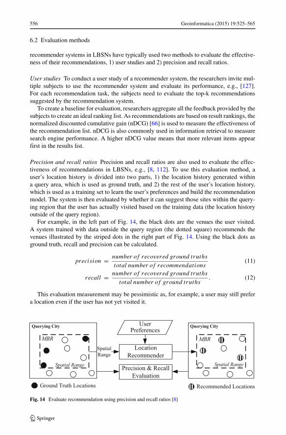
556 Geoinformatica (2015) 19:525–565
6.2 Evaluation methods
recommender systems in LBSNs have typically used two methods to evaluate the effective-ness of their recommendations, 1) user studies and 2) precision and recall ratios.
User studies To conduct a user study of a recommender system, the researchers invite mul-tiple subjects to use the recommender system and evaluate its performance, e.g., [127].For each recommendation task, the subjects need to evaluate the top-k recommendationssuggested by the recommendation system.
To create a baseline for evaluation, researchers aggregate all the feedback provided by thesubjects to create an ideal ranking list. As recommendations are based on result rankings, thenormalized discounted cumulative gain (nDCG) [66] is used to measure the effectiveness ofthe recommendation list. nDCG is also commonly used in information retrieval to measuresearch engine performance. A higher nDCG value means that more relevant items appearfirst in the results list.
Precision and recall ratios Precision and recall ratios are also used to evaluate the effec-tiveness of recommendations in LBSNs, e.g., [8, 112]. To use this evaluation method, auser’s location history is divided into two parts, 1) the location history generated withina query area, which is used as ground truth, and 2) the rest of the user’s location history,which is used as a training set to learn the user’s preferences and build the recommendationmodel. The system is then evaluated by whether it can suggest those sites within the query-ing region that the user has actually visited based on the training data (the location historyoutside of the query region).
For example, in the left part of Fig. 14, the black dots are the venues the user visited.A system trained with data outside the query region (the dotted square) recommends thevenues illustrated by the striped dots in the right part of Fig. 14. Using the black dots asground truth, recall and precision can be calculated.
precision = number of recovered ground truths
total number of recommendations(11)
recall = number of recovered ground truths
total number of ground truths. (12)
This evaluation measurement may be pessimistic as, for example, a user may still prefera location even if the user has not yet visited it.
Precision & Recall
Evaluation
Location
Recommender
Spatial Range Spatial Range
Spatial
Range
Ground Truth Locations Recommended Locations
Querying City Querying CityUser
Preferences
MBR MBR
Fig. 14 Evaluate recommendation using precision and recall ratios [8]
Geoinformatica (2015) 19:525–565 557
7 Future work
Although many recommender systems have been proposed in LBSNs, there are still manyopen questions and challenges to be addressed. In this section, we summarize potentialresearch directions to improve the effectiveness and efficiency of recommender systems inLBSNs.
7.1 Effectiveness of recommendations
To improve their effectiveness, recommender systems need more accurate estimations ofuser preferences and social knowledge. Potential paths to achieve this include 1) usingdiverse data sources, 2) integrating and hybridizing different types of recommendationmethodologies, and 3) increasing context awareness.
Diverse data sources Most recommender systems in LBSNs currently use only one type ofthe data source to make recommendations. However, there are many different types data inLBSNs, e.g., users’ friendships, online interactions, and user location histories. By consid-ering more diversified data sources, more effective recommendations can be provided. Forinstance, the user online interactions, social structures, and location histories are all veryrelevant to friend recommendation. If two users have more online interactions, are close inthe social structure, and have overlapped location histories, these users are likely to be com-patible. A friend recommender system that can consider all these factors will make higherquality friend recommendations. In addition, other data sources outside LBSNs, such asPOIs, road networks, and traffic conditions, can also be considered in the recommendation.fusing the knowledge from multiple heterogeneous data sources into a recommendationsystem is also a challenge [130].
Hybrid methodologies The recommendation methodologies used in the existing recom-mender systems each have their own drawbacks. For example, in collaborative filteringbased recommender systems, data sparsity and cold starts are challenging problems. Linkanalysis-based recommender systems avoid these problems, but only provide genericrecommendations that ignore users’ personal preferences. By integrating CF and linkanalysis-based techniques, a hybrid recommender system could overcome the weaknessesof both.
Context awareness Current recommender systems in LBSNs use a user’s history to extractpreferences. However, the user’s context is currently ignored. A context aware recommendersystem in LBSNs would need to consider 1) user context, including static attributes likeincome, profession, and age, as well as dynamic attributes include current user location,mood, and status, (e.g., at home or in meeting) and 2) environmental context, includ-ing information about the surrounding environment, e.g. the current time, weather, trafficconditions, events, etc.
7.2 Efficiency of recommendations
Recommendations in LBSNs can be computationally costly, especially given the frequencywith which users add new location data and content.
User mobility Users in LBSNs interact with the services using mobile devices and want up-to-date recommendations based on their current location. However, processing continuous
558 Geoinformatica (2015) 19:525–565
recommendation requests as multiple individual requests is inefficient as many redun-dant computations are undertaken between the consecutive recommendation queries. Toaddress this, more advanced recommendation algorithms are required that leverage priorcomputations to reduce the cost of continuous recommendation requests.
Frequent user updates Users in LBSNs can be very active. They visit many locations overshort time spans, which adds information related to their preferences at a high rate. It is veryinefficient to re-compute the user preferences and user similarities every time a user under-takes a new activity. As a result, new recommendation techniques are required to efficientlyaddress the update frequency in LBSNs.
8 Conclusion
Motivated by the prevalence of location-based social networks and the importance of rec-ommender systems, we have provided a systematic survey of the related recent research. Westudied over 60 papers published in the last five years, including but not limited to KDD,WWW, RecSys, UbiComp, ACM SIGSPATIAL LBSN, ACM TIST, and ACM TWEB. Weprovided categorizations of existing systems in regard to their data sources, their methodolo-gies, and their recommendation objective. This survey presents a panorama of this researchwith a balanced depth and scope. Further, this survey serves as a tutorial, introducing theconcepts, unique properties, challenges, representative solutions and systems, evaluationmethods, and future work for recommender systems in LBSNs.
References
1. Adomavicius G, Tuzhilin A (2005) Toward the next generation of recommender systems: a survey ofthe state-of-the-art and possible extensions. IEEE Trans Knowl Data Eng 17(6):734–749
2. Agrawal R, Srikant R et al (1994) Fast algorithms for mining association rules. In: Proc. 20th int. conf.very large data bases, VLDB, vol 1215, pp 487–499
3. Arase Y, Xie X, Duan M, Hara T, Nishio S (2009) A game based approach to assign geographicalrelevance to web images. In: Proceedings of the 18th international conference on World wide web.ACM, pp 811–820
4. Arase Y, Xie X, Hara T, Nishio S (2010) Mining people’s trips from large scale geo-tagged photos. In:Proceedings of the international conference on multimedia. ACM, pp 133–142
5. Backstrom L, Leskovec J (2011) Supervised random walks: predicting and recommending links insocial networks. In: Proceedings of the fourth ACM international conference on Web search and datamining. ACM, pp 635–644
6. Backstrom L, Sun E, Marlow C (2010) Find me if you can: improving geographical prediction withsocial and spatial proximity. In: Proceedings of the 19th international conference on World wide web.ACM, pp 61–70
7. Ballatore A, McArdle G, Kelly C, Bertolotto M (2010) Recomap: an interactive and adaptive map-basedrecommender. In: Proceedings of the 2010 ACM symposium on applied computing. ACM, pp 887–891
8. Bao J, Zheng Y, Mokbel M (2012) Location-based and preference-aware recommendation using sparsegeo-social networking data. In: ACM SIGSPATIAL
9. Borzsony S, Kossmann D, Stocker K (2001) The skyline operator. In: 2001 Proceedings 17thinternational conference on data engineering. IEEE, pp 421–430
10. Bouidghaghen O, Tamine L, Boughanem M (2011) Personalizing mobile web search for location sen-sitive queries. In: 2011 12th IEEE international conference on mobile data management (MDM), vol 1.IEEE, pp 110–118
11. Brockmann D, Hufnagel L, Geisel T (2006) The scaling laws of human travel. Nature 439(7075):462–465
12. Burt RS (1999) The social capital of opinion leaders. Ann Amer Acad Polit Social Sci 566(1):37–54
Geoinformatica (2015) 19:525–565 559
13. Cao X, Cong G, Jensen CS (2010) Mining significant semantic locations from gps data. Proc VLDBEndowment 3(1–2):1009–1020
14. Chakrabarti S, Dom B, Raghavan P, Rajagopalan S, Gibson D, Kleinberg J (1998) Automatic resourcecompilation by analyzing hyperlink structure and associated text. Comput Netw ISDN Syst 30(1):65–74
15. Chang K-P, Wei L-Y, Peng W-C, Yeh M-Y (2011) Discovering personalized routes from tejaectories.In: GIS-LBSN
16. Chen J, Geyer W, Dugan C, Muller M, Guy I (2009) Make new friends, but keep the old: recommendingpeople on social networking sites. In: Proceedings of the SIGCHI conference on human factors incomputing systems. ACM, pp 201–210
17. Chen Y, Wang W, Liu Z, Lin X (2009) Keyword search on structured and semi-structured data. In:Proceedings of the 2009 ACM SIGMOD international conference on management of data. ACM, pp1005–1010
18. Cheng Z, Caverlee J, Lee K, Sui DZ (2011) Exploring millions of footprints in location sharing services.ICWSM 2011:81–88
19. Cho E, Myers SA, Leskovec J (2011) Friendship and mobility: user movement in location-based socialnetworks. In: Proceedings of the 17th ACM SIGKDD international conference on knowledge discoveryand data mining. ACM, pp 1082–1090
20. Chow C-Y, Bao J, Mokbel MF (2010) Towards location-based social networking services. In: The 2ndACM SIGSPATIAL international workshop on location based social networks
21. Couldry N, McCarthy A (2004) Mediaspace: place, scale and culture in a media age. Routledge22. Cranshaw J, Toch E, Hong J, Kittur A, Sadeh N (2010) Bridging the gap between physical location
and online social networks. In: Proceedings of the 12th ACM international conference on Ubiquitouscomputing. ACM, pp 119–128
23. Daly EM, Geyer W (2011) Effective event discovery: using location and social information for scopingevent recommendations. In: Proceedings of the fifth ACM conference on recommender systems. ACM,pp 277–280
24. Das AS, Datar M, Garg A, Rajaram S (2007) Google news personalization: scalable online collaborativefiltering. In: Proceedings of the 16th international conference on World wide web. ACM, pp 271–280
25. Del Prete L (2010) Licia Capra: differs: A mobile recommender service. In: 2010 eleventh internationalconference on mobile data management (MDM). IEEE, pp 21–26
26. DeScioli P, Kurzban R, Koch EN, Liben-Nowell D (2011) Best friends alliances, friend ranking, andthe myspace social network. Perspect Psychol Sci 6(1):6–8
27. Doyle PG, Laurie Snell J (1984) Random walks and electric networks. Carus Math Monogr:2228. Doytsher Y, Galon B, Kanza Y (2011) Storing routes in socio-spatial networks and supporting social-
based route recommendation. In: Proceedings of the 3nd ACM SIGSPATIAL international workshopon location based social networks. ACM
29. Eagle N, Pentland A (2006) Reality mining: sensing complex social systems. Personal Ubiquit Comput10(4):255–268
30. Eagle N, Pentland AS (2009) Eigenbehaviors: identifying structure in routine. Behav Ecol Sociobiol63(7):1057–1066
31. Eagle N, Pentland AS, Lazer D (2009) Inferring friendship network structure by using mobile phonedata. Proc Natl Acad Sci 106(36):15274–15278
32. Ference G, Ye M, Lee W-C (2013) Location recommendation for out-of-town users in location-based social networks. In: Proceedings of the 22nd ACM international conference on conference oninformation & knowledge management. ACM, pp 721–726
33. Gao H, Tang J, Hu X, Liu H (2013) Exploring temporal effects for location recommendation onlocation-based social networks. In: Proceedings of the 7th ACM conference on recommender systems.ACM, pp 93–100
34. Gao H, Tang J, Liu H (2014) Addressing the cold-start problem in location recommendation usinggeo-social correlations. Data Min Knowl Discov:1–25
35. Ge Y, Liu Q, Xiong H, Tuzhilin A, Chen J (2011) Cost-aware travel tour recommendation. In: Pro-ceedings of the 17th ACM SIGKDD international conference on knowledge discovery and data mining.ACM, pp 983–991
36. Ge Y, Xiong H, Tuzhilin A, Xiao K, Gruteser M, Pazzani M (2010) An energy-efficient mobile rec-ommender system. In: Proceedings of the 16th ACM SIGKDD international conference on knowledgediscovery and data mining. ACM, pp 899–908
37. Getoor L, Diehl CP (2005) Link mining: a survey. ACM SIGKDD Explor Newslett 7(2):3–1238. Gilbert E, Karahalios K (2009) Predicting tie strength with social media. In: Proceedings of the SIGCHI
conference on human factors in computing systems. ACM, pp 211–220
560 Geoinformatica (2015) 19:525–565
39. Goldenberg J, Levy M (2009) Distance is not dead: social interaction and geographical distance in theinternet era. arXiv:0906.3202
40. Han J-W, Pei J, Yan X-F (2004) From sequential pattern mining to structured pattern mining: a pattern-growth approach. J Comput Sci Technol 19(3):257–279
41. Han J, Pei J, Yin Y (2000) Mining frequent patterns without candidate generation. In: ACM SIGMODrecord, vol 29–2. ACM, pp 1–12
42. Hao Q, Cai R, Wang C, Xiao R, Yang J-M, Pang Y, Zhang L (2010) Equip tourists with knowledgemined from travelogues. In: Proceedings of the 19th international conference on World wide web.ACM, pp 401–410
43. Harding M, Finney J, Davies N, Rouncefield M, Hannon J (2013) Experiences with a social travelinformation system. In: Proceedings of the 2013 ACM international joint conference on pervasive andubiquitous computing. ACM, pp 173–182
44. Herlocker JL, Konstan JA, Borchers A, Riedl J (1999)45. Horozov T, Narasimhan N, Vasudevan V (2006) Using location for personalized poi recommendations
in mobile environments. In: International symposium on applications and the internet. SAINT 2006.IEEE, 6–pp
46. Hu B, Ester M (2013) Spatial topic modeling in online social media for location recommendation. In:Proceedings of the 7th ACM conference on recommender systems. ACM, pp 25–32
47. Huang L, Li Q, Yue Y (2010) Activity identification from gps trajectories using spatial temporal pois’attractiveness. In: Proceedings of the 2nd ACM SIGSPATIAL international workshop on location basedsocial networks. ACM, pp 27–30
48. Hung C-C, Chang C-W, Peng W-C (2009) Mining trajectory profiles for discovering user communities.In: Proceedings of the 2009 international workshop on location based social networks. ACM, pp 1–8
49. Jiang B, Yin J, Zhao S (2009) Characterizing the human mobility pattern in a large street network. PhysRev E 80(2):021136
50. Kawakubo H, Yanai K (2011) Geovisualrank: a ranking method of geotagged imagesconsidering visualsimilarity and geo-location proximity. In: Proceedings of the 20th international conference companionon World wide web. ACM, pp 69–70
51. Kleinberg JM (1999) Authoritative sources in a hyperlinked environment. J ACM (JACM) 46(5):604–632
52. Kodama K, Iijima Y, Guo X, Ishikawa Y (2009) Skyline queries based on user locations and preferencesfor making location-based recommendations. In: Proceedings of the 2009 international workshop onlocation based social networks. ACM, pp 9–16
53. Lemire D, Maclachlan A (2005) Slope one predictors for online rating-based collaborative filtering. In:SDM, vol5. SIAM, pp 1–5
54. Leung KW-T, Lee DL, Lee W-C (2011) Clr: a collaborative location recommendation framework basedon co-clustering. In: Proceedings of the 34th international ACM SIGIR conference on research anddevelopment in information retrieval. ACM, pp 305–314
55. Levandoski J, Sarwat M, Eldawy A, Mokbel M (2012) Lars: a location-aware recommender system.In: IEEE international conference on data engineering
56. Li Q, Zheng Y, Xie X, Chen Y, Liu W, Ma W-Y (2008) Mining user similarity based on loca-tion history. In: Proceedings of the 16th ACM SIGSPATIAL international conference on advances ingeographic information systems. ACM, p 34
57. Li Y, Zhang Z-L, Bao J (2012) Mutual or unrequited love: Identifying stable clusters in social networkswith uni-and bi-directional links. In: Algorithms and models for the web graph. Springer, pp 113–125
58. Lian D, Xie X (2011) Learning location naming from user check-in histories. In: ACM SIGSPATIAL.ACM
59. Liben-Nowell D, Novak J, Kumar R, Raghavan P, Tomkins A (2005) Geographic routing in socialnetworks. Proc Natl Acad Sci USA 102(33):11623–11628
60. Lin Y-R, Sun J, Castro P, Konuru R, Sundaram H, Kelliher A (2009) Metafac: community discov-ery via relational hypergraph factorization. In: Proceedings of the 15th ACM SIGKDD internationalconference on knowledge discovery and data mining. ACM, pp 527–536
61. Linden G, Smith B, York J (2003) Amazon. com recommendations: item-to-item collaborative filtering.IEEE Int Comput 7(1):76–80
62. Liu B, Fu Y, Yao Z, Xiong H (2013) Learning geographical preferences for point-of-interest recommen-dation. In: Proceedings of the 19th ACM SIGKDD international conference on knowledge discoveryand data mining. ACM, pp 1043–1051
63. Liu H, Wei L-Y, Zheng Y, Schneider M, Peng W-C (2011) Route discovery from mining uncertaintrajectories. In: 2011 IEEE 11th international conference on data mining workshops (ICDMW). IEEE,pp 1239–1242
Geoinformatica (2015) 19:525–565 561
64. Lu C-T, Lei P-R, Peng W-C, Su J (2011) A framework of mining semantic regions from trajectories.In: Database systems for advanced applications. Springer, pp 193–207
65. Lu X, Wang C, Yang J-M, Pang Y, Zhang L (2010) Photo2trip: generating travel routes from geo-tagged photos for trip planning. In: Proceedings of the international conference on multimedia. ACM,pp 143–152
66. Manning CD, Raghavan P, Schutze H (2008) Introduction to information retrieval, vol 1. CambridgeUniversity Press, Cambridge
67. Masli M, Bouma L, Owen A, Terveen L (2013) Geowiki+ route analysis= improved transportationplanning. In: Proceedings of the 2013 conference on computer supported cooperative work companion.ACM, pp 213–218
68. Mishra N, Schreiber R, Stanton I, Tarjan RE (2007) Clustering social networks. In: Algorithms andmodels for the web-graph. Springer, pp 56–67
69. Mokbel M, Bao J, Eldawy A, Levandoski J, Sarwat M (2011) Personalization, socialization, and rec-ommendations in location-based services 2.0. In: 5th international VLDB workshop on personalizedaccess, profile management and context awareness in databases (PersDB). VLDB
70. MovieLens. http://www.MovieLens.org/71. NetFlix Prize Data. http://www.netflixprize.com/72. Noulas A, Mascolo C, Frias-Martinez E (2013) Exploiting foursquare and cellular data to infer
user activity in urban environments. In: 2013 IEEE 14th international conference on mobile datamanagement (MDM), vol 1. IEEE, pp 167–176
73. Noulas A, Scellato S, Mascolo C, Pontil M (2011) An empirical study of geographic user activitypatterns in foursquare. ICWSM 11:70–573
74. Page L, Brin S, Motwani R, Winograd T (1999) The pagerank citation ranking. Bringing order to theweb. Technical Report
75. Panagiotis S, Alexis P, Yannis M, Pinar S, Ismail T (2011) Geo-social recommendations based onincremental tensor reduction and local path traversal. In: Proceedings of the 3nd ACM SIGSPATIALinternational workshop on location based social networks. ACM
76. Park M-H, Hong J-H, Cho S-B (2007) Location-based recommendation system using bayesian userspreference model in mobile devices. In: Ubiquitous intelligence and computing. Springer, pp 1130–1139
77. Alexei P, Christian K (2011) Space-time dynamics of topics in streaming text. In: Proceedings of the3rd ACM SIGSPATIAL international workshop on location-based social networks. ACM, pp 1–8
78. Quercia D, Lathia N, Calabrese F, Di Lorenzo G, Crowcroft J (2010) Recommending socialevents from mobile phone location data. In: International conference on data mining. IEEE,pp 971–976
79. Rahimi SM, Wang Xin (2013) Location recommendation based on periodicity of human activities andlocation categories. In: Advances in knowledge discovery and data mining. Springer, pp 377–389
80. Ramaswamy L, Deepak P, Polavarapu R, Gunasekera K, Garg D, Visweswariah K, Kalyanara-man S (2009) Caesar: a context-aware, social recommender system for low-end mobile devices. In:Tenth international conference on mobile data management: systems, services and middleware, 2009.MDM’09. IEEE, pp 338–347
81. Raymond R, Sugiura T, Tsubouchi K (2011) Location recommendation based on location history andspatio-temporal correlations for an on-demand bus system. In: ACM SIGSPATIAL. ACM
82. Roth M, Assaf B-D, Deutscher D, Flysher G, Horn I, Leichtberg A, Leiser N, Matias Y, Merom R(2010) Suggesting friends using the implicit social graph. In: Proceedings of the 16th ACM SIGKDDinternational conference on knowledge discovery and data mining. ACM, pp 233–242
83. Sandholm T, Ung H (2011) Real-time, location-aware collaborative filtering of web content. In: Pro-ceedings of the 2011 workshop on context-awareness in retrieval and recommendation. ACM, pp14–18
84. Sarwat M, Eldawy A, Mokbel MF, Riedl J (2013) Plutus: leveraging location-based social networks torecommend potential customers to venues. In: 2013 IEEE 14th international conference on mobile datamanagement (MDM), vol 1. IEEE, pp 26–35
85. Scellato S, Mascolo C, Musolesi M, Crowcroft J (2011) Track globally, deliver locally: improving con-tent delivery networks by tracking geographic social cascades. In: Proceedings of the 20th internationalconference on World wide web. ACM, pp 457–466
86. Scellato S, Noulas A, Lambiotte R, Mascolo C (2011) Socio-spatial properties of online location-basedsocial networks, vol 11
87. Scellato S, Noulas A, Mascolo C (2011) Exploiting place features in link prediction on location-basedsocial networks. In: Proceedings of the 17th ACM SIGKDD international conference on knowledgediscovery and data mining. ACM, pp 1046–1054
562 Geoinformatica (2015) 19:525–565
88. Schein AI, Popescul A, Ungar LH, Pennock DM (2002) Methods and metrics for cold-start recom-mendations. In: Proceedings of the 25th annual international ACM SIGIR conference on research anddevelopment in information retrieval. ACM, pp 253–260
89. Shi Y, Serdyukov P, Hanjalic A, Larson M (2011) Personalized landmark recommendation based ongeotags from photo sharing sites. ICWSM 11:622–625
90. Silva A, Martins B (2011) Tag recommendation for georeferenced photos. In: Proceedings of the 3ndACM SIGSPATIAL international workshop on location based social networks. ACM
91. Singh AP, Gordon GJ (2008) Relational learning via collective matrix factorization. In: Proceedings ofthe 14th ACM SIGKDD international conference on knowledge discovery and data mining. ACM, pp650–658
92. Srebro N, Jaakkola T et al (2003) Weighted low-rank approximations. In: ICML, vol 3, pp 720–72793. Srikant R, Agrawal R (1996) Mining sequential patterns: generalizations and performance improve-
ments. Springer94. Tai CH, Yang D-N, Lin LT, Chen MS (2008) Recommending personalized scenic itinerarywith geo-
tagged photos. In: 2008 IEEE international conference on multimedia and expo. IEEE, pp 1209–121295. Takeuchi Y, Sugimoto M (2006) Cityvoyager: an outdoor recommendation system based on user
location history. In: Ubiquitous intelligence and computing. Springer, pp 625–63696. Tang KP, Lin J, Hong JI, Siewiorek DP, Sadeh N (2010) Rethinking location sharing: exploring the
implications of social-driven vs. purpose-driven location sharing. In: Proceedings of the 12th ACMinternational conference on ubiquitous computing. ACM, pp 85–94
97. Waldo R (1970) Tobler: a computer movie simulating urban growth in the detroit region. EconGeogr:234–240
98. Thomas W (1996) Valente: social network thresholds in the diffusion of innovations. Social Netw18(1):69–89
99. Venetis P, Gonzalez H, Jensen CS, Halevy A (2011) Hyper-local, directions-based ranking of places.Proc VLDB Endowment 4(5):290–301
100. Von Luxburg U (2007) A tutorial on spectral clustering. Stat Comput 17(4):395–416101. Weakliam J, Bertolotto M, Wilson D (2005) Implicit interaction profiling for recommending spatial
content. In: Proceedings of the 13th annual ACM international workshop on geographic informationsystems. ACM, pp 285–294
102. Wei L-Y, Zheng Y, Peng W-C (2012) Constructing popular routes from uncertain trajectories. In:Proceedings of the 18th ACM SIGKDD international conference on knowledge discovery and datamining. ACM, pp 195–203
103. Wiese J, Kelley PG, Cranor LF, Dabbish L, Hong JI, Zimmerman J (2011) Are you close with me? areyou nearby?: investigating social groups, closeness, and willingness to share. In: Proceedings of the13th international conference on ubiquitous computing. ACM, pp 197–206
104. Xiang R, Neville J, Rogati M (2010) Modeling relationship strength in online social networks. In:Proceedings of the 19th international conference on World wide web. ACM, pp 981–990
105. Xiao X, Zheng Y, Luo Q, Xie X (2010) Finding similar users using category-based location history. In:Proceedings of the 18th SIGSPATIAL international conference on advances in geographic informationsystems. ACM, pp 442–445
106. Xiao X, Zheng Y, Luo Q, Xie X (2014) Inferring social ties between users with human location history,vol 5
107. Xu W, Chow C-Y, Zhang J-D (2013) Calba: capacity-aware location-based advertising in temporarysocial networks. In: Proceedings of the 21st ACM SIGSPATIAL international conference on advancesin geographic information systems. ACM, pp 354–363
108. Yang D, Zhang D, Yu Z, Yu Z (2013) Fine-grained preference-aware location search leveraging crowd-sourced digital footprints from lbsns. In: Proceedings of the 2013 ACM international joint conferenceon pervasive and ubiquitous computing. ACM, pp 479–488
109. Ye M, Janowicz K, Mulligann C, Lee W-C (2011) What you are is when you are: the temporaldimension of feature types in location-based social networks. In: Proceedings of the 19th ACMSIGSPATIAL international conference on advances in geographic information systems. ACM, pp102–111
110. Ye M, Shou D, Lee W-C, Yin P, Janowicz K (2011) On the semantic annotation of places inlocation-based social networks. In: Proceedings of the 17th ACM SIGKDD international conferenceon knowledge discovery and data mining. ACM, pp 520–528
111. Ye M, Yin P, Lee W-C (2010) Location recommendation for location-based social networks. In: Pro-ceedings of the 18th SIGSPATIAL international conference on advances in geographic informationsystems. ACM, pp 458–461
Geoinformatica (2015) 19:525–565 563
112. Ye M, Yin P, Lee W-C, Lee D-L (2011) Exploiting geographical influence for collaborative point-of-interest recommendation. In: Proceedings of the 34th international ACM SIGIR conference on researchand development in information retrieval. ACM, pp 325–334
113. Ye Y, Zheng Y, Chen Y, Feng J, Xie X (2009) Mining individual life pattern based on location history.In: Tenth international conference on mobile data management: systems, services and middleware,2009. MDM’09. IEEE, pp 1–10
114. Yin H, Sun Y, Cui B, Hu Z, Chen L (2013) Lcars: a location-content-aware recommender system.In: Proceedings of the 19th ACM SIGKDD international conference on knowledge discovery and datamining. ACM, pp 221–229
115. Yin Z, Cao L, Han J, Luo J, Huang TS (2011) Diversified trajectory pattern ranking in geo-taggedsocial media. In: SDM. SIAM, pp 980–991
116. Yin Z, Cao L, Han J, Zhai C, Huang T (2011) Geographical topic discovery and comparison. In:Proceedings of the 20th international conference on World wide web. ACM, pp 247–256
117. Yin Z, Gupta M, Weninger T, Han J (2010) Linkrec: a unified framework for link recommendation withuser attributes and graph structure. In: Proceedings of the 19th international conference on World wideweb. ACM, pp 1211–1212
118. Ying JJ-C, Lee W-C, Ye M, Chen TC-Y, Tseng VS. (2011) User association analysis of locales onlocation based social networks. In: GIS-LBSN
119. Ying JJ-C, Lu EH-C, Kuo W-N, Tseng VS (2012) Urban point-of-interest recommendation by min-ing user check-in behaviors. In: Proceedings of the ACM SIGKDD international workshop on urbancomputing. ACM, pp 63–70
120. Ying JJ-C, Lu EH-C, Lee W-C, Weng T-C, Tseng VS (2010) Mining user similarity from semantictrajectories. In: Proceedings of the 2nd ACM SIGSPATIAL international workshop on location basedsocial networks. ACM, pp 19–26
121. Yoon H, Zheng Y, Xie X, Woo W (2010) Smart itinerary recommendation based on user-generated gpstrajectories. In: Ubiquitous intelligence and computing. Springer, pp 19–34
122. Yoon H, Zheng Y, Xie X, Woo W (2012) Social itinerary recommendation from user-generated digitaltrails. Personal Ubiquit Comput 16(5):469–484
123. Yu X, Pan A, Tang L-A, Li Z, Han J (2011) Geo-friends recommendation in gps-based cyber-physicalsocial network. In: 2011 International conference on advances in social networks analysis and mining(ASONAM). IEEE, pp 361–368
124. Zhang D, Chee YM, Mondal A, Tung A, Kitsuregawa M (2009) Keyword search in spatial databases:towards searching by document. In: IEEE 25th international conference on data engineering, 2009.ICDE’09. IEEE, pp 688–699
125. Zhang J-D, Chow C-Y (2013) igslr: personalized geo-social location recommendation: a kernel den-sity estimation approach. In: Proceedings of the 21st ACM SIGSPATIAL international conference onadvances in geographic information systems. ACM, pp 324–333
126. Zheng V, Cao B, Zheng Y, Xie X, Yang Q (2010a) Collaborative filtering meets mobile recommenda-tion: a user-centered approach. In: AAAI conference on artificial intelligence
127. Zheng VW, Zheng Y, Xie X, Yang Q (2010) Collaborative location and activity recommendations withgps history data. In: Proceedings of the 19th international conference on World wide web. ACM, pp1029–1038
128. Zheng VW, Zheng Y, Xie X, Yang Q (2012) Towards mobile intelligence: learning from gps historydata for collaborative recommendation. Artif Intell 184:17–37
129. Zheng VW, Zheng Y, Yang Q (2009) Joint learning user’s activities and profiles from gps data. In:Proceedings of the 2009 international workshop on location based social networks. ACM, pp 17–20
130. Zheng Y, Capra L, Wolfson O, Yang H (2014) Urban computing: concepts, methodologies, andapplications. ACM Trans Intell Syst Technol (ACM TIST)
131. Zheng Y, Chen Y, Xie X, Ma W-Y (2009c) GeoLife2.0: a location-based social networking service.In: MDM
132. Zheng Y, Xie X (2010) Learning location correlation from gps trajectories. In: 2010 Eleventhinternational conference on mobile data management (MDM). IEEE, pp 27–32
133. Zheng Y, Xie X (2011) Learning travel recommendations from user-generated gps traces. ACM TransIntell Sys Technol (TIST) 2(1):2
134. Zheng Y, Zhang L, Ma Z, Xie X, Ma W-Y (2011) Recommending friends and locations based onindividual location history. ACM Trans Web (TWEB) 5(1):5
135. Zheng Y, Zhang L, Xie X, Ma W-Y (2009) Mining correlation between locations using human loca-tion history. In: Proceedings of the 17th ACM SIGSPATIAL international conference on advances ingeographic information systems. ACM, pp 472–475

564 Geoinformatica (2015) 19:525–565
136. Zheng Y, Zhang L, Xie X, Ma W-Y (2009) Mining interesting locations and travel sequences from gpstrajectories. In: Proceedings of the 18th international conference on World wide web. ACM, pp 791–800
137. Zheng Y, Zhou X (2011) Computing with spatial trajectories. Springer
Jie Bao is a Ph.D student in University of Minnesota. He got hisbachlor and master degree from Zhejiang University and AuburnUniversity in 2007 and 2009 respectively. He is interested in thespatial data management, location-based services, social networkingservices and recommendations.
Dr. Yu Zheng is a lead researcher from Microsoft Research. He isalso a Chair Professor at Shanghai Jiao Tong University and an Affili-ate Professor at Southwest Jiaotong University. His research interestsinclude urban big data analytics, spatio-temporal data mining, andubiquitous computing. Specifically, he is passionate about usingurban big data to tackle cities’ challenges. He has published over 50referred papers as a leading author at prestigious conferences andjournals, such as SIGMOD, VLDB, SIGKDD, UbiComp, and IEEETKDE. He received five best paper awards from ICDE’13, ACMSIGSPATIAL’10, and Ubicomp’11, etc. Zheng is currently a mem-ber of Editorial Advisory Board of IEEE Spectrum. He has servedas chair on 10 prestigious international conferences–most recently,as the program co-chair of ICDE 2014. He has been invited to giveover 10 keynote speeches at international conferences and forums(e.g. IE 2014, ISKE 2013 and APEC 2014 smart city forum). Zhenghas been featured multiple times by influential journals. In 2013, hewas named one of the Top Innovators under 35 by MIT Technology
Review (TR35) for his research using data science to solve urban challenges. He was featured by Time Mag-azine due to his research on urban computing in Nov 2013. In 2014, he was named one of the top 40 BusinessElites under 40 in China by Fortune Magazine, because of the business impact of urban computing he hasbeen advocating since 2008.
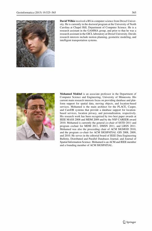
Geoinformatica (2015) 19:525–565 565
David Wilkie received a BS in computer science from Drexel Univer-sity. He is currently in the doctoral program at the University of NorthCarolina at Chapel Hill, Department of Computer Science. He is aresearch assistant in the GAMMA group, and prior to that he was aresearch assistant in the GICL laboratory at Drexel University. Davidsresearch interests include motion planning, geometric modeling, andintelligent transportation systems.
Mohamed Mokbel is an associate professor in the Department ofComputer Science and Engineering, University of Minnesota. Hiscurrent main research interests focus on providing database and plat-form support for spatial data, moving objects, and location-basedservices. Mohamed is the main architect for the PLACE, Casper,and CareDB systems that provide a database support for location-based services, location privacy, and personalization, respectively.His research work has been recognized by two best paper awards atIEEE MASS 2008 and MDM 2009 and by the NSF CAREER award2010. Mohamed is currently the general co-chair of SSTD 2011 andprogram cochair for MDM 2011, DMSN 2011, and LBSN 2011.Mohamed was also the proceeding chair of ACM SIGMOD 2010,and the program co-chair for ACM SIGSPATIAL GIS 2008, 2009,and 2010. He serves in the editorial board of IEEE Data EngineeringBulletin, Distributed and Parallel Databases Journal, and Journal ofSpatial Information Science. Mohamed is an ACM and IEEE memberand a founding member of ACM SIGSPATIAL.