Defence Research and Development Canada Recherche et développement pour la défense Canada Canada Recognized Maritime Picture Tools and Analysis Mr Steven Horn DRDC CORA, JTFP OR Team October 2009
Recherche et développementpour la défense Canada Canada
Recognized Maritime Picture Tools and Analysis
Mr Steven HornDRDC CORA, JTFP OR Team
October 2009
Presenter
Presentation Notes
Presentation to MORS Workshop: Analytic Support for Maritime Domain Awareness and Counter-Piracy, October 2009 Presented by: Steven Horn, DRDC CORA
Report Documentation Page Form ApprovedOMB No. 0704-0188
Public reporting burden for the collection of information is estimated to average 1 hour per response, including the time for reviewing instructions, searching existing data sources, gathering andmaintaining the data needed, and completing and reviewing the collection of information. Send comments regarding this burden estimate or any other aspect of this collection of information,including suggestions for reducing this burden, to Washington Headquarters Services, Directorate for Information Operations and Reports, 1215 Jefferson Davis Highway, Suite 1204, ArlingtonVA 22202-4302. Respondents should be aware that notwithstanding any other provision of law, no person shall be subject to a penalty for failing to comply with a collection of information if itdoes not display a currently valid OMB control number.
1. REPORT DATE OCT 2009 2. REPORT TYPE
3. DATES COVERED 00-00-2009 to 00-00-2009
4. TITLE AND SUBTITLE Recognized Maritime Picture Tools and Analysis
5a. CONTRACT NUMBER
5b. GRANT NUMBER
5c. PROGRAM ELEMENT NUMBER
6. AUTHOR(S) 5d. PROJECT NUMBER
5e. TASK NUMBER
5f. WORK UNIT NUMBER
7. PERFORMING ORGANIZATION NAME(S) AND ADDRESS(ES) Defence R&D Canada -CORA,Joint Task Force (Pacific),PO BOX 17000Stn. Forces,Victoria, British Columbia, CanadaV9A 7N2,
8. PERFORMING ORGANIZATIONREPORT NUMBER
9. SPONSORING/MONITORING AGENCY NAME(S) AND ADDRESS(ES) 10. SPONSOR/MONITOR’S ACRONYM(S)
11. SPONSOR/MONITOR’S REPORT NUMBER(S)
12. DISTRIBUTION/AVAILABILITY STATEMENT Approved for public release; distribution unlimited
13. SUPPLEMENTARY NOTES Maritime Domain Awareness and Counter Piracy, 26-29 October 2009, Ottawa, Canada
14. ABSTRACT
15. SUBJECT TERMS
16. SECURITY CLASSIFICATION OF: 17. LIMITATION OF ABSTRACT Same as
Report (SAR)
18. NUMBEROF PAGES
24
19a. NAME OFRESPONSIBLE PERSON
a. REPORT unclassified
b. ABSTRACT unclassified
c. THIS PAGE unclassified
Standard Form 298 (Rev. 8-98) Prescribed by ANSI Std Z39-18
Defence R & D Canada – CORA • R & D pour la défense Canada – CARO
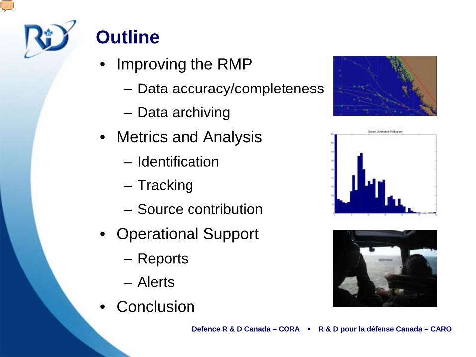
Outline• Improving the RMP
– Data accuracy/completeness– Data archiving
• Metrics and Analysis– Identification– Tracking– Source contribution
• Operational Support– Reports– Alerts
• Conclusion
Presenter
Presentation Notes
Addresses three main subjects suggested in the TOR: Improving the RMP. -addresses the “exploitation of information to develop and disseminate decision quality MDA” Metrics and Analysis -includes “processing, analysis and exploitation of available sensor, information and intelligence” Operational Support -”the identification, tasking, scheduling and coordination of available surveillance assets”
Defence R & D Canada – CORA • R & D pour la défense Canada – CARO
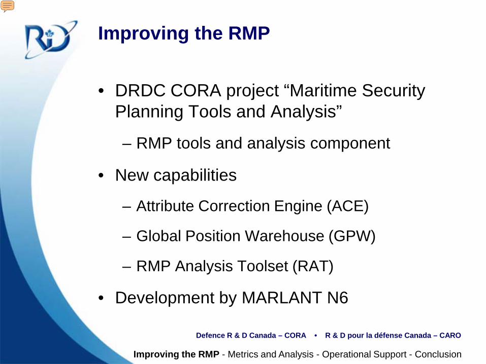
Improving the RMP
• DRDC CORA project “Maritime Security Planning Tools and Analysis”
– RMP tools and analysis component
• New capabilities
– Attribute Correction Engine (ACE)
– Global Position Warehouse (GPW)
– RMP Analysis Toolset (RAT)
• Development by MARLANT N6
Improving the RMP - Metrics and Analysis - Operational Support - Conclusion
Presenter
Presentation Notes
The bulk of this presentation is work that is being done under DRDC CORA ARP on Maritime Security Planning Tools and Analysis WBE4: RMP tools and analysis. Although this project officially started in April 2009, work on the topic was already underway in both JTFA and JTFP Operational Research Teams. The work introduces three main components to the architecture: ACE, GPW, and RAT. The next slide shows more information on the new architecture
Defence R & D Canada – CORA • R & D pour la défense Canada – CARO
Archive
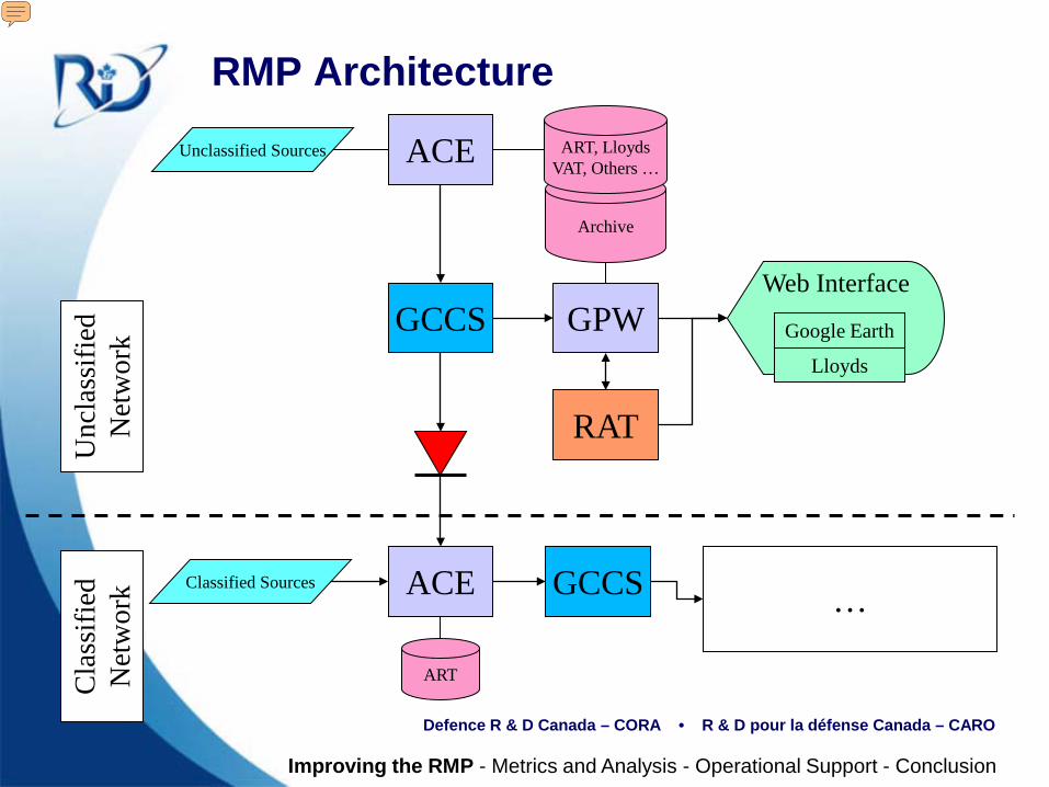
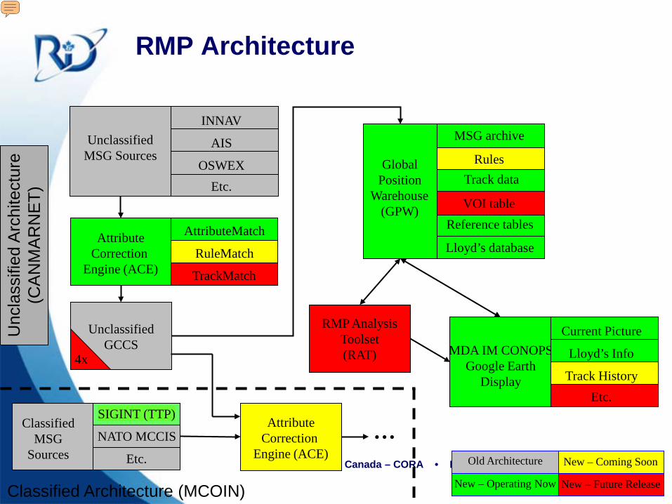
RMP Architecture
Unclassified Sources ACE
GCCS GPW
ART, LloydsVAT, Others …
RAT
Web Interface
Google Earth
Lloyds
Classified Sources ACE
ART
GCCS …
Unc
lass
ified
N
etw
ork
Cla
ssifi
ed
Net
wor
k
Improving the RMP - Metrics and Analysis - Operational Support - Conclusion
Presenter
Presentation Notes
Unclassified Architecture: Unclassified sources are increasing in number. New sources include: LRIT AIS Data from other government departments ACE works in three stages to clean the incoming messages before they enter GCCS AttributeMatch is online now and helps to fill in missing information. If a contact comes in with only part of its identification information, AttributeMatch tries to find a match in Lloyds or our own reference tables and fill in the rest of the information RuleMatch will be online in the next release and allows operators to set rules for fixing repeating mistakes in contact reports. This includes misspellings, incorrect information, etc. TrackMatch will be implemented in a future release and will attempt to match contacts to an existing track when AttributeMatch and RuleMatch are unsuccessful. This will largely be for unknown contacts, matching to tracks based on geo-feasibility. Also, a minimum distance algorithm is used to correlate by name to existing tracks and assist with track correlation. This process of matching new contact reports with known vessels and existing tracks will reduce the number of unknowns and ambiguities in the picture. We are already seeing much longer tracks meaning that tracks are being fused into longer segments than previously. Once the data is clean it is displayed, as usual, in GCCS. A web interface to the GPW service allows a user to query the current RMP, in addition to the historical RMP. Google Earth Pro is used as the visualization front-end. The user can also cross-reference data in the RMP to other data sources such as Lloyds by following links. RAT interfaces with GPW and is a set of tools and stored procedures to present to the user reports, on-demand metrics, or alerts. On the classified side, ACE is also implemented with the unclassified RMP as an input in addition to other classified sources. The entire architecture is repeated on the classified network
Defence R & D Canada – CORA • R & D pour la défense Canada – CARO
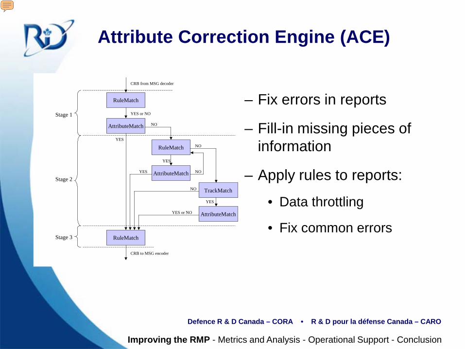
Attribute Correction Engine (ACE)
AttributeMatch
RuleMatch
RuleMatch
TrackMatch
RuleMatch
AttributeMatch
AttributeMatch
Stage 1
Stage 2
Stage 3
YES
NO
YES
YES or NO
NO
YES
NO
YES or NO
YES
NO
CRB from MSG decoder
CRB to MSG encoder
– Fix errors in reports
– Fill-in missing pieces of information
– Apply rules to reports:
• Data throttling
• Fix common errors
Improving the RMP - Metrics and Analysis - Operational Support - Conclusion
Presenter
Presentation Notes
The Attribute Correction Engine (ACE) has three stages. Stage 1: Data is pre-cleaned and the reports are compared against a database, if there is a database entry, extra information is filled in. Stage 2: More advanced rules are applied to the reports, the reports are analyzed for errors and completeness. The data is again compared against the database. The data is also compared against the RMP to check if there are any existing tracks or possible spelling errors in the reports. Stage 3:Post-cleaning rules are applied. This includes data throttling and identification of vessels with alerts.
Defence R & D Canada – CORA • R & D pour la défense Canada – CARO
Global Position Warehouse (GPW)
• Global Position Warehouse (GPW)
– Archives reports post-ACE for historic analysis.
– Filters tracks
– Ability to sort tracks by common properties (category, location, flag, etc.)
Screenshots:
Improving the RMP - Metrics and Analysis - Operational Support - Conclusion
Presenter
Presentation Notes
GPW is an archive of all data that was shown in GCCS. An important feature of GPW is the Intelligence Collection Structure (ICS) feature, which allows the user to sort through the history by certain criteria, in addition to traditional searching methods.
Defence R & D Canada – CORA • R & D pour la défense Canada – CARO
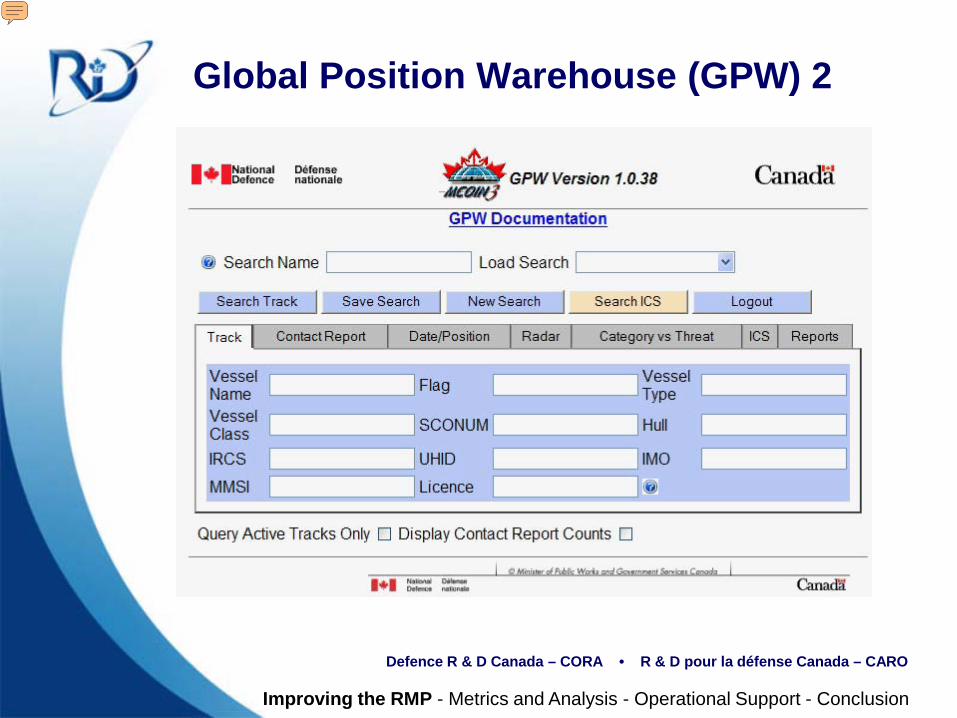
Global Position Warehouse (GPW) 2
Improving the RMP - Metrics and Analysis - Operational Support - Conclusion
Presenter
Presentation Notes
This is a screenshot of the Operational GPW front-end interface.
Defence R & D Canada – CORA • R & D pour la défense Canada – CARO
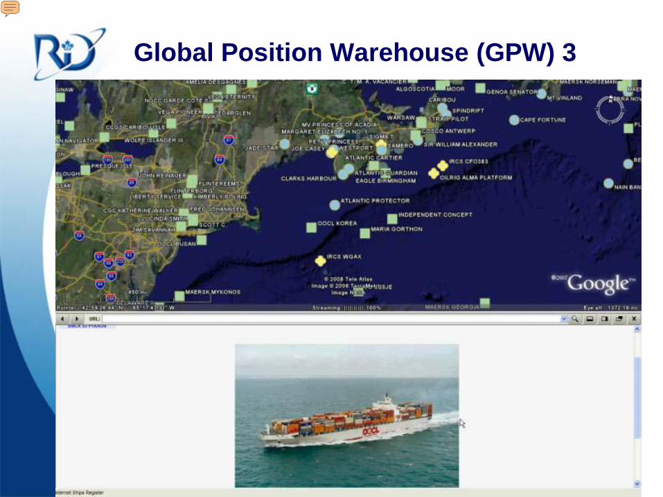
Global Position Warehouse (GPW) 3
Presenter
Presentation Notes
A search in GPW has the option to be displayed on Google Earth. Once in GE, the user can click on tracks for more information. See below, a search in Lloyds for the ship image.
Defence R & D Canada – CORA • R & D pour la défense Canada – CARO
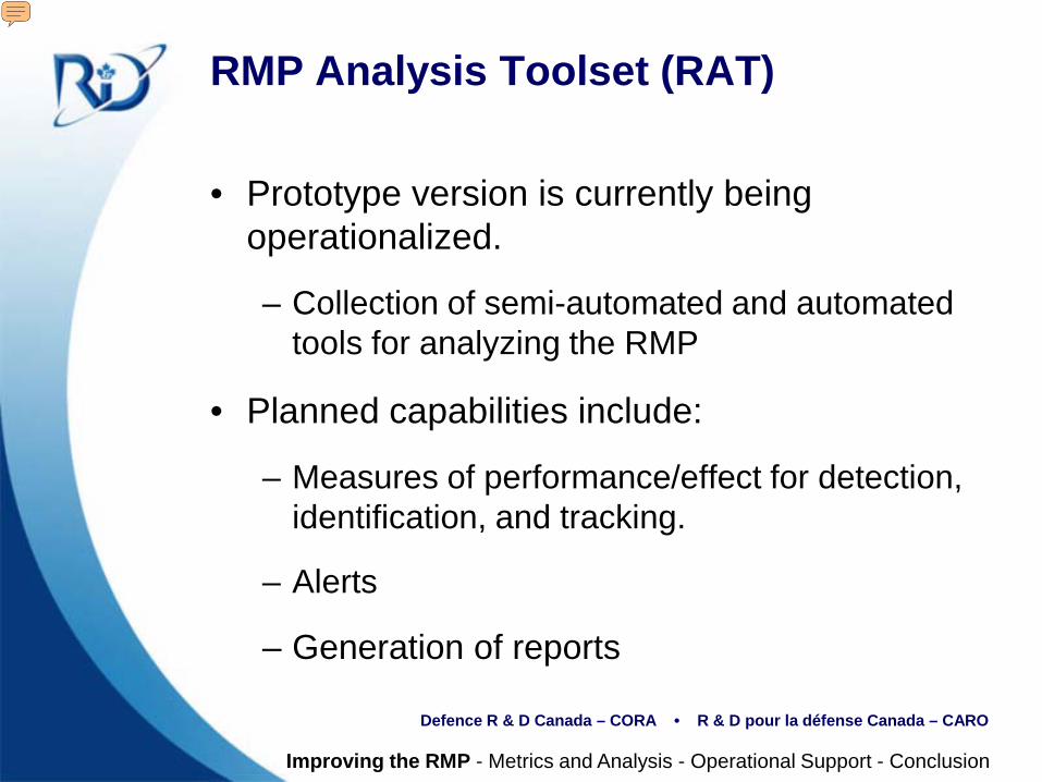
RMP Analysis Toolset (RAT)
• Prototype version is currently being operationalized.
– Collection of semi-automated and automated tools for analyzing the RMP
• Planned capabilities include:
– Measures of performance/effect for detection, identification, and tracking.
– Alerts
– Generation of reports
Improving the RMP - Metrics and Analysis - Operational Support - Conclusion
Presenter
Presentation Notes
RAT is the core analysis component of the new RMP architecture. RAT is a collection of tools which will provide services to the operator. A prototype version (PRAT) is used by researchers, to develop new tools to be operationalized in RAT. RAT has the ability to run some tools automatically (e.g. to generate alerts when certain conditions are met). It can also generate reports on demand (e.g. weekly or quarterly reports)
Defence R & D Canada – CORA • R & D pour la défense Canada – CARO
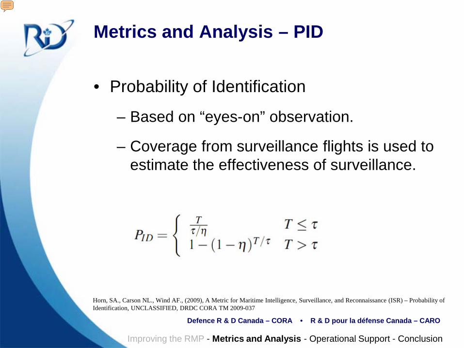
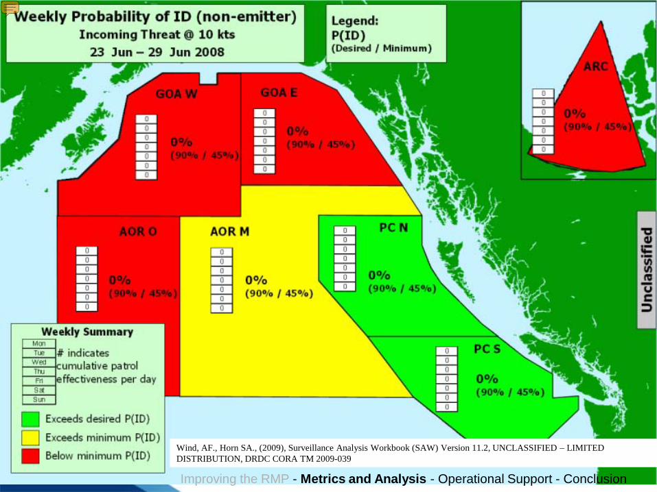
Metrics and Analysis – PID
• Probability of Identification
– Based on “eyes-on” observation.
– Coverage from surveillance flights is used to estimate the effectiveness of surveillance.
Horn, SA., Carson NL., Wind AF., (2009), A Metric for Maritime Intelligence, Surveillance, and Reconnaissance (ISR) – Probability of Identification, UNCLASSIFIED, DRDC CORA TM 2009-037
Improving the RMP - Metrics and Analysis - Operational Support - Conclusion
Presenter
Presentation Notes
Probability of Identification is a measure of the effect of surveillance for identification. The first implementation is limited to reporting PID only by visual or active sensing. PID is a function of the frequency of patrols (tau), the transit time (T), and the patrol effectiveness (eta). Note that PID is a function of the speed of targets. There are future plans to expand the metric to include identification by passive sensors. See ref. for more information
Defence R & D Canada – CORA • R & D pour la défense Canada – CARO
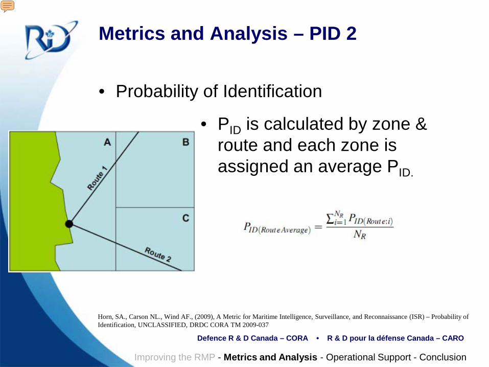
Metrics and Analysis – PID 2
• Probability of Identification
Horn, SA., Carson NL., Wind AF., (2009), A Metric for Maritime Intelligence, Surveillance, and Reconnaissance (ISR) – Probability of Identification, UNCLASSIFIED, DRDC CORA TM 2009-037
• PID is calculated by zone & route and each zone is assigned an average PID.
Improving the RMP - Metrics and Analysis - Operational Support - Conclusion
Presenter
Presentation Notes
PID is calculated by dividing an area of interest into patrol zones. High traffic routes through the zones are identified and the probability of identifying traffic along the routes through each zone is calculated using the PID equation. The calculation filters for incoming routes, to simplify the interpretation of the metric. The final reported PID value is the average PID for all incoming routes terminating in a patrol zone.
Defence R & D Canada – CORA • R & D pour la défense Canada – CARO
Improving the RMP - Metrics and Analysis - Operational Support - Conclusion
Example of a weekly PID report. No information is entered in this report, the inner zones and middle zone is coloured for effect. See ref. for more information on the generation of the report
Defence R & D Canada – CORA • R & D pour la défense Canada – CARO
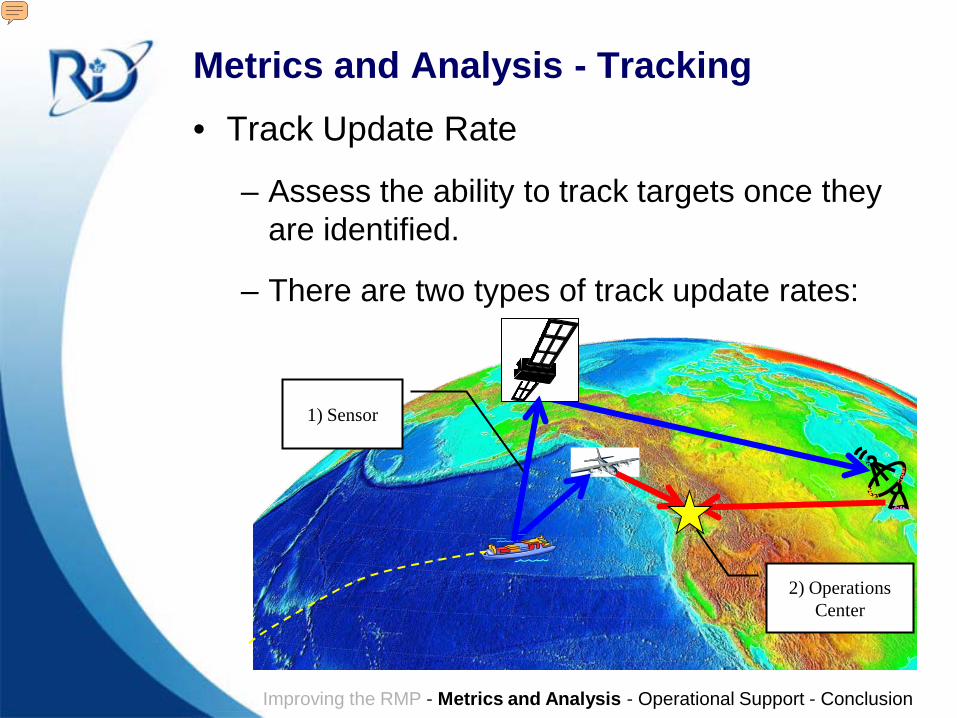
Metrics and Analysis - Tracking• Track Update Rate
– Assess the ability to track targets once they are identified.
– There are two types of track update rates:
2) Operations Center
1) Sensor
Improving the RMP - Metrics and Analysis - Operational Support - Conclusion
Presenter
Presentation Notes
The Track Update rate metric is based on the ability to track ships in the RMP once they are identified. There are two important parts to this metric: The sensor component, and the operations center component. Because there are multiple sensors observing the same ships, the latency between the sensor and the Operations Center plays an important role for how often the track will be updated in the RMP. The update rates are a function of the coverage, and the latency of the position reports.
Defence R & D Canada – CORA • R & D pour la défense Canada – CARO
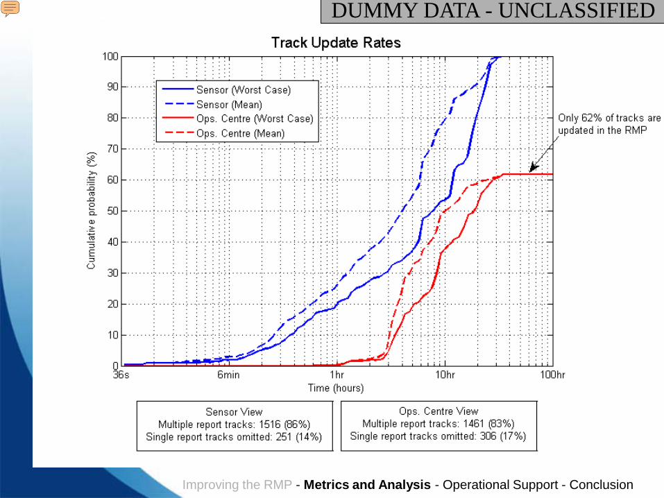
DUMMY DATA - UNCLASSIFIED
Improving the RMP - Metrics and Analysis - Operational Support - Conclusion
Presenter
Presentation Notes
For a given area, the update rates for all tracks is analyzed statistically. The X axis has the time to update the track, and the Y axis is a cumulative probability. Ideally, the less time to update a track, the better. Note that the sensor and Ops. Center values are not the same. This is because some of the position reports from some sensors will not provide an update to the RMP position if another sensor provides an update sooner. There are therefore two avenues to improve the tracking in the RMP: Increased sensor coverage, and Decrease sensor latency.
Defence R & D Canada – CORA • R & D pour la défense Canada – CARO
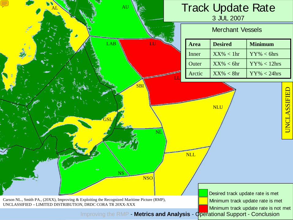
AL AU
LAB LU
LL
NL
NS
SBI
NLU
NLL
NSO
GSL
UN
CLA
SSIF
IED
Track Update Rate3 JUL 2007
Merchant Vessels
Desired track update rate is metMinimum track update rate is metMinimum track update rate is not met
YY% < 24hrsXX% < 8hrArctic
YY% < 12hrsXX% < 6hrOuter
YY% < 6hrsXX% < 1hrInner
MinimumDesiredArea
Improving the RMP - Metrics and Analysis - Operational Support - Conclusion
By defining standards for the update rate, the metric can be run on specific areas providing a spatially distributed report.
Defence R & D Canada – CORA • R & D pour la défense Canada – CARO
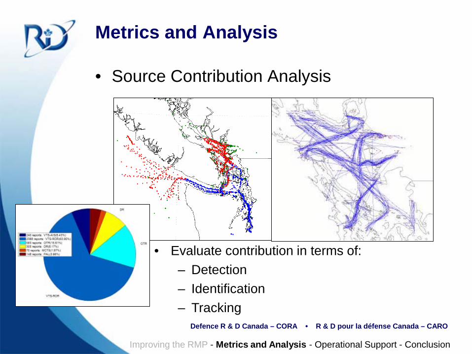
Metrics and Analysis
• Source Contribution Analysis
Improving the RMP - Metrics and Analysis - Operational Support - Conclusion
• Evaluate contribution in terms of:– Detection– Identification– Tracking
Defence R & D Canada – CORA • R & D pour la défense Canada – CARO
Operational Support
• Added value to RMP: from dots to MDA
• Reports provide a new way for decision makers to use MDA.
• New information for improved planning.
– Better understanding of sensors
– MOEs and MOPs
• Alerts and analysis to improve responsiveness.
Improving the RMP - Metrics and Analysis - Operational Support - Conclusion
Presenter
Presentation Notes
RAT provides new information for decision makers. This is useful for improving planning methods (e.g. allocation of resources) One goal of this work is to be able to generate information to perform more cueued reconnaissance missions based on analysis of information. Hopefully, this would improve the effectiveness of high-cost assets.
Defence R & D Canada – CORA • R & D pour la défense Canada – CARO
Conclusion
• Work is continuing to improve the RMP architecture
• Continued research & development
– New metrics, new algorithms, etc.
• Products are being deployed for use by operational staff
Improving the RMP - Metrics and Analysis - Operational Support - Conclusion
Presenter
Presentation Notes
Improving the RMP – The new architecture continues to be developed Metrics and Analysis – Defence research continues to prototype new concepts. Operational Support – Working closely with military partners, new technology is being applied to help operations.
Defence R & D Canada – CORA • R & D pour la défense Canada – CARO
Acknowledgements
• Neil Carson (NORAD ORT)
• Pete Smith (MARLANT ORT)
• Andrew Wind (MARLANT ORT)
Improving the RMP - Metrics and Analysis - Operational Support - Conclusion
Presenter
Presentation Notes
I am not the first person working on this project, and hopefully, won’t be the last. Much of the original work was done by Mr. Neil Carson and Mr. Pete Smith.
Defence R & D Canada – CORA • R & D pour la défense Canada – CARO
Contact
Steven Horn
Operational Research (J02 OR)Joint Task Force (Pacific)PO BOX 17000 Stn. ForcesVictoria, British Columbia, CanadaV9A 7N2
Improving the RMP - Metrics and Analysis - Operational Support - Conclusion
Presenter
Presentation Notes
Contact Information
Defence R & D Canada – CORA • R & D pour la défense Canada – CARO
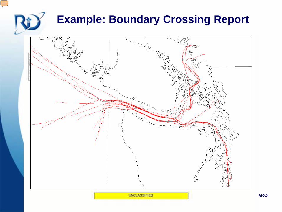
Example: Boundary Crossing Report
Presenter
Presentation Notes
The boundary crossing report identifies tracks in a dataset that cross over a pre-defined line. This is useful to identify which tracks are inbound and where they came from.
Defence R & D Canada – CORA • R & D pour la défense Canada – CARO
Unc
lass
ified
Arc
hite
ctur
e(C
AN
MA
RN
ET)
UnclassifiedMSG Sources
INNAV
AIS
Etc.OSWEX Rules
Reference tables
Lloyd’s database
MSG archive
VOI table
GlobalPosition
Warehouse(GPW)
Track data
AttributeCorrection
Engine (ACE) TrackMatch
AttributeMatch
RuleMatch
UnclassifiedGCCS MDA IM CONOPS
Google EarthDisplay
Current Picture
Lloyd’s Info
Etc.Track History
RMP AnalysisToolset(RAT)
Old Architecture
New – Operating Now New – Future Release
New – Coming Soon
Legend
Classified Architecture (MCOIN)
AttributeCorrection
Engine (ACE)
ClassifiedMSG
Sources
SIGINT (TTP)
NATO MCCIS
Etc.
…
4x
RMP Architecture
Presenter
Presentation Notes
N02OR prototyped the new architecture Now I hope you don’t mind but I need to make a bit more room on the slide Additional unclassified sources are expected in service in 2009/10: LRIT (long range identification and tracking) & CG’s shored-based AIS ACE works in three stages to clean the incoming messages before they enter GCCS AttributeMatch is online now and helps to fill in missing information. If a contact comes in with only part of its identification information, AttributeMatch tries to find a match in Lloyds or our own reference tables and fill in the rest of the information RuleMatch will be online in the next release and allows operators to set rules for fixing repeating mistakes in contact reports. This includes misspellings, incorrect information, etc. TrackMatch will be implemented in a future release and will attempt to match contacts to an existing track when AttributeMatch and RuleMatch are unsuccessful. This will largely be for unknown contacts, matching to tracks based on geo-feasibility. This process of matching new contact reports with known vessels and existing tracks will reduce the number of unknowns and ambiguities in the picture. We are already seeing much longer tracks meaning that tracks are being fused into longer segments than previously. GPW is a database that holds the complete historical archive of contact reports and tracks that are broadcast from GCCS. GPW also contains the Lloyds ship information, our own additional reference table for vessels not found in Lloyds, and it will hold a VOI table to alert operators when a known VOI is in the picture. Other pieces of information including the rules for ACE RuleMatch will also be held here. The GPW can be queried for information through a web application but more powerful is the connection that has been built to GoogleEarth for displaying the picture. The Google Earth display can show the current picture in near-real-time with less than a 5 min delay. It is also possible from there to select a vessel and bring up the Lloyds website information for the vessel. In the future more features will be added such as being able to select a vessel and show its track history. The RMP Analysis Toolset will provide reports and analyses for exploiting the RMP and these results will also be displayed in Google Earth. There are several reports and analyses that have already been developed by N02OR in the prototyping environment, and together with the RJOC we have a prioritized list for future development. The operational version, RAT, will be implemented in segments as modules become available and subject to N6 resource availability. One thing to note is that the GPW and Google Earth interfaces are available on CANMARNET as secure web based services. As such, MSOC partners can be given access to the unclassified RMP through these CANMARNET interfaces. ---------- Now to look at the classified architecture, it will be a similar copy but placed on MCOIN/CSNI. Here the classified sources are received and will be passed to the classified ACE. These sources include the SIGINT sources which pass through TTP (The Translator Program) developed by Pete. The broadcast from the unclassified GCCS is also sent to the classified ACE. Most of this data has already been cleaned by the unclassified ACE. The classified ACE and GPW are currently waiting for equipment purchases and an RFC but should be implemented in Feb/Mar. At this point, because the unclassified data is already passing through ACE it is already helping to clean the classified picture also. Once implemented, MSOC East will have access to the classified RMP interfaces on MCOIN ------------------ When GCCS 4x comes, it will replace the old GCCS. This is part of the reason for the updated architecture because the old archive (CHDB) will not be compatible with GCCS 4x.
Defence R & D Canada – CORA • R & D pour la défense Canada – CARO
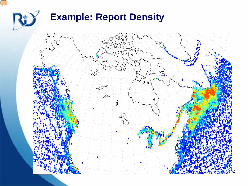
Example: Report Density
Presenter
Presentation Notes
The image illustrates a 1-month time period for reports from the unclassified C2 system. Warmer colors indicate more reports, white = no reports.