Embed Size (px)
Citation preview
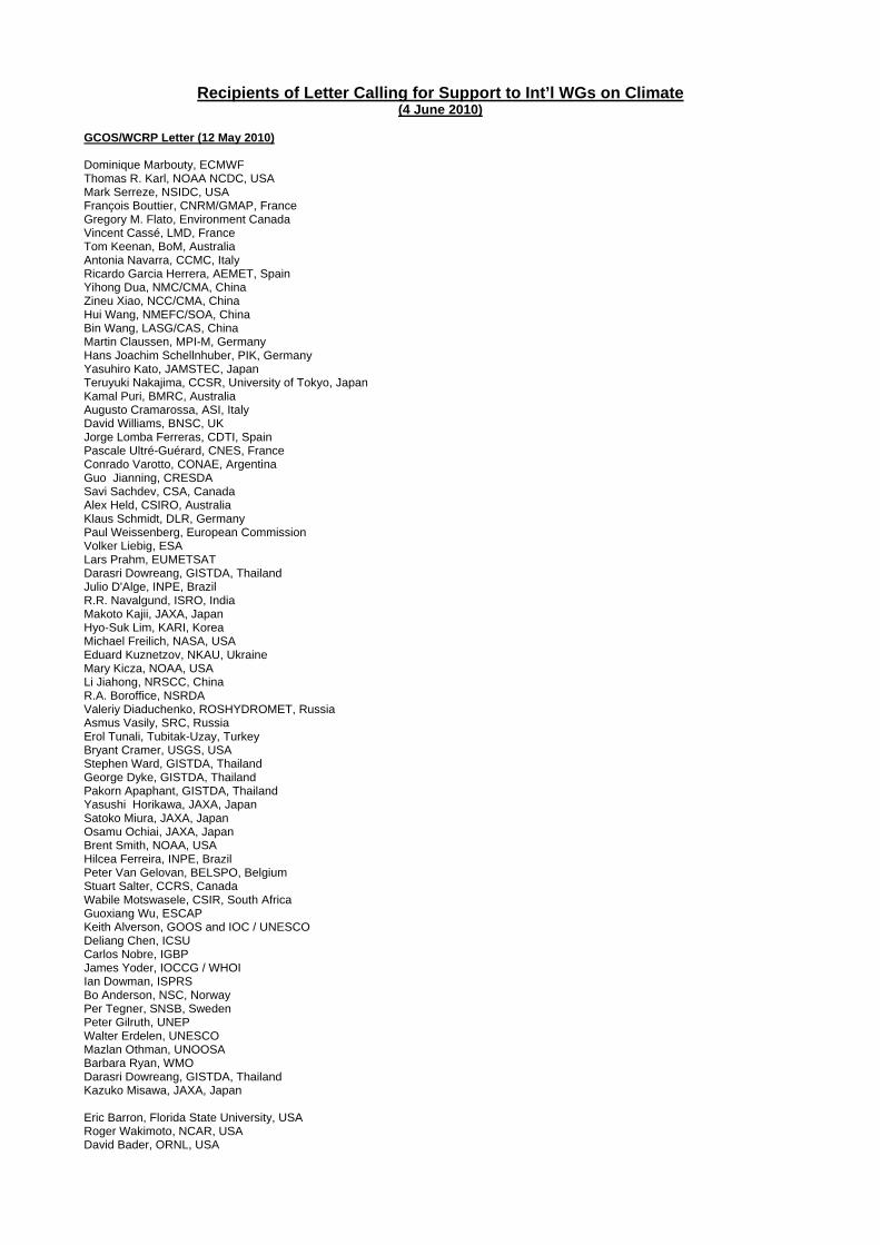
Recipients of Letter Calling for Support to Int’l WGs on Climate (4 June 2010)
GCOS/WCRP Letter (12 May 2010) Dominique Marbouty, ECMWF Thomas R. Karl, NOAA NCDC, USA Mark Serreze, NSIDC, USA François Bouttier, CNRM/GMAP, France Gregory M. Flato, Environment Canada Vincent Cassé, LMD, France Tom Keenan, BoM, Australia Antonia Navarra, CCMC, Italy Ricardo Garcia Herrera, AEMET, Spain Yihong Dua, NMC/CMA, China Zineu Xiao, NCC/CMA, China Hui Wang, NMEFC/SOA, China Bin Wang, LASG/CAS, China Martin Claussen, MPI-M, Germany Hans Joachim Schellnhuber, PIK, Germany Yasuhiro Kato, JAMSTEC, Japan Teruyuki Nakajima, CCSR, University of Tokyo, Japan Kamal Puri, BMRC, Australia Augusto Cramarossa, ASI, Italy David Williams, BNSC, UK Jorge Lomba Ferreras, CDTI, Spain Pascale Ultré-Guérard, CNES, France Conrado Varotto, CONAE, Argentina Guo Jianning, CRESDA Savi Sachdev, CSA, Canada Alex Held, CSIRO, Australia Klaus Schmidt, DLR, Germany Paul Weissenberg, European Commission Volker Liebig, ESA Lars Prahm, EUMETSAT Darasri Dowreang, GISTDA, Thailand Julio D'Alge, INPE, Brazil R.R. Navalgund, ISRO, India Makoto Kajii, JAXA, Japan Hyo-Suk Lim, KARI, Korea Michael Freilich, NASA, USA Eduard Kuznetzov, NKAU, Ukraine Mary Kicza, NOAA, USA Li Jiahong, NRSCC, China R.A. Boroffice, NSRDA Valeriy Diaduchenko, ROSHYDROMET, Russia Asmus Vasily, SRC, Russia Erol Tunali, Tubitak-Uzay, Turkey Bryant Cramer, USGS, USA Stephen Ward, GISTDA, Thailand George Dyke, GISTDA, Thailand Pakorn Apaphant, GISTDA, Thailand Yasushi Horikawa, JAXA, Japan Satoko Miura, JAXA, Japan Osamu Ochiai, JAXA, Japan Brent Smith, NOAA, USA Hilcea Ferreira, INPE, Brazil Peter Van Gelovan, BELSPO, Belgium Stuart Salter, CCRS, Canada Wabile Motswasele, CSIR, South Africa Guoxiang Wu, ESCAP Keith Alverson, GOOS and IOC / UNESCO Deliang Chen, ICSU Carlos Nobre, IGBP James Yoder, IOCCG / WHOI Ian Dowman, ISPRS Bo Anderson, NSC, Norway Per Tegner, SNSB, Sweden Peter Gilruth, UNEP Walter Erdelen, UNESCO Mazlan Othman, UNOOSA Barbara Ryan, WMO Darasri Dowreang, GISTDA, Thailand Kazuko Misawa, JAXA, Japan Eric Barron, Florida State University, USA Roger Wakimoto, NCAR, USA David Bader, ORNL, USA

Stephen Lord, NCEP, USA Tim Kileen, NSF, USA Anna Palmisano, US Department of Energy Jack Kaye, NASA, USA Diane Evans, NASA; USA Alan Thorpe, NERC, UK Steven Wilson, NERC, UK Jan-Gunnar Winther, NPO, Norway Sandven Stein, Nansen Environmental and Remote Sensing Centre, Norway Joseph Alcamo, UNEP Duncan Wingham, University College London, UK Yann Kerr, CESBIO, France Reiner Rummel, TU Munich, Germany Gary Lagerloef, Earth System Research, USA David Crisp, NASA, USA Michael Mishchenko, NASA, USA Berrien Moore III, Climate Central, USA
Annex I
INTERNATIONAL SCIENTIFIC WORKING GROUPS AND OTHER EXPERT BODIES RELEVANT TO THE
GENERATION AND EVALUATION OF FUNDAMENTAL CLIMATE DATA RECORDS AND
ESSENTIAL CLIMATE VARIABLE PRODUCTS
(DRAFT)
May 2010
For further details on these groups (members, mandate etc.), please contact:
Global Climate Observing System Secretariat ([email protected]) or World Climate Research Programme ([email protected])
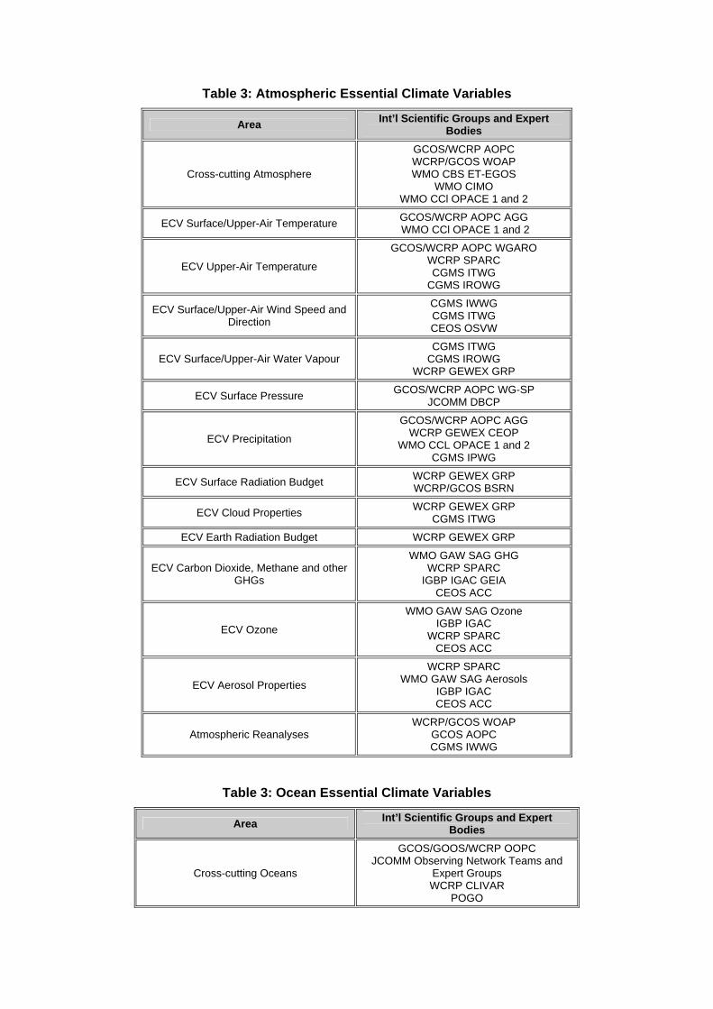
Table 3: Atmospheric Essential Climate Variables
Area Int’l Scientific Groups and Expert Bodies
Cross-cutting Atmosphere
GCOS/WCRP AOPC WCRP/GCOS WOAP WMO CBS ET-EGOS
WMO CIMO WMO CCl OPACE 1 and 2
ECV Surface/Upper-Air Temperature GCOS/WCRP AOPC AGG WMO CCl OPACE 1 and 2
ECV Upper-Air Temperature
GCOS/WCRP AOPC WGARO WCRP SPARC CGMS ITWG
CGMS IROWG
ECV Surface/Upper-Air Wind Speed and Direction
CGMS IWWG CGMS ITWG CEOS OSVW
ECV Surface/Upper-Air Water Vapour CGMS ITWG
CGMS IROWG WCRP GEWEX GRP
ECV Surface Pressure GCOS/WCRP AOPC WG-SP JCOMM DBCP
ECV Precipitation
GCOS/WCRP AOPC AGG WCRP GEWEX CEOP
WMO CCL OPACE 1 and 2 CGMS IPWG
ECV Surface Radiation Budget WCRP GEWEX GRP WCRP/GCOS BSRN
ECV Cloud Properties WCRP GEWEX GRP CGMS ITWG
ECV Earth Radiation Budget WCRP GEWEX GRP
ECV Carbon Dioxide, Methane and other GHGs
WMO GAW SAG GHG WCRP SPARC
IGBP IGAC GEIA CEOS ACC
ECV Ozone
WMO GAW SAG Ozone IGBP IGAC
WCRP SPARC CEOS ACC
ECV Aerosol Properties
WCRP SPARC WMO GAW SAG Aerosols
IGBP IGAC CEOS ACC
Atmospheric Reanalyses WCRP/GCOS WOAP
GCOS AOPC CGMS IWWG
Table 3: Ocean Essential Climate Variables
Area Int’l Scientific Groups and Expert Bodies
Cross-cutting Oceans
GCOS/GOOS/WCRP OOPC JCOMM Observing Network Teams and
Expert Groups WCRP CLIVAR
POGO
ECV Sea Surface Temperature
GCOS/WCRP OOPC WG SST & Sea Ice WCRP/GCOS WOAP
GHRSST JCOMM DBCP JCOMM SOOP
ECV Ocean Surface Salinity
WCRP CLIVAR GSOP SMOS and Aquarius/SAC-D science teams
Argo Steering Committee JCOMM SOOP
ECV Sea Level JCOMM GLOSS
CEOS OST Ocean Surface Topography Science Team
ECV Sea State JCOMM Expert Team on Wind, Waves and Storm Surges
ECV Sea Ice
WCRP CliC ASPeCt Expert Group
GCOS/GOOS/WCRP OOPC WG SST & Sea Ice
JCOMM Expert Team on Sea Ice IICWG
ECV Surface Current JCOMM DBCP
CEOS OST CEOS OSVW
ECV Ocean Colour IOCCG IOCCP
CEOS OCR
ECV Carbon dioxide partial pressure IOCCP GCOS/GOOS/WCRP OOPC
ECV Ocean Acidity IOCCP GCOS/GOOS/WCRP OOPC
ECV Sub-Surface Temperature
Argo Steering Team JCOMM SOOP
JCOMM DBCP/TIP IOCCP
GO-SHIP WCRP CLIVAR GSOP
OceanSITES
ECV Sub-Surface Salinity
Argo Steering Team JCOMM TIP
IOCCP GO-SHIP
WCRP CLIVAR GSOP
ECV Sub-Surface Current
Argo Steering Team OceanSITES JCOMM TIP
GO-SHIP
ECV Sub-Surface Nutrients
IOCCP GO-SHIP
IGBP IMBER GEOTRACES
ECV Sub-Surface Carbon dioxide partial pressure
IOCCP GO-SHIP
GCOS/GOOS/WCRP OOPC
ECV Sub-Surface Ocean Acidity IOCCP
GO-SHIP WCRP CLIVAR GSOP
ECV Sub-Surface Oxygen IOCCP
GO-SHIP WCRP CLIVAR GSOP
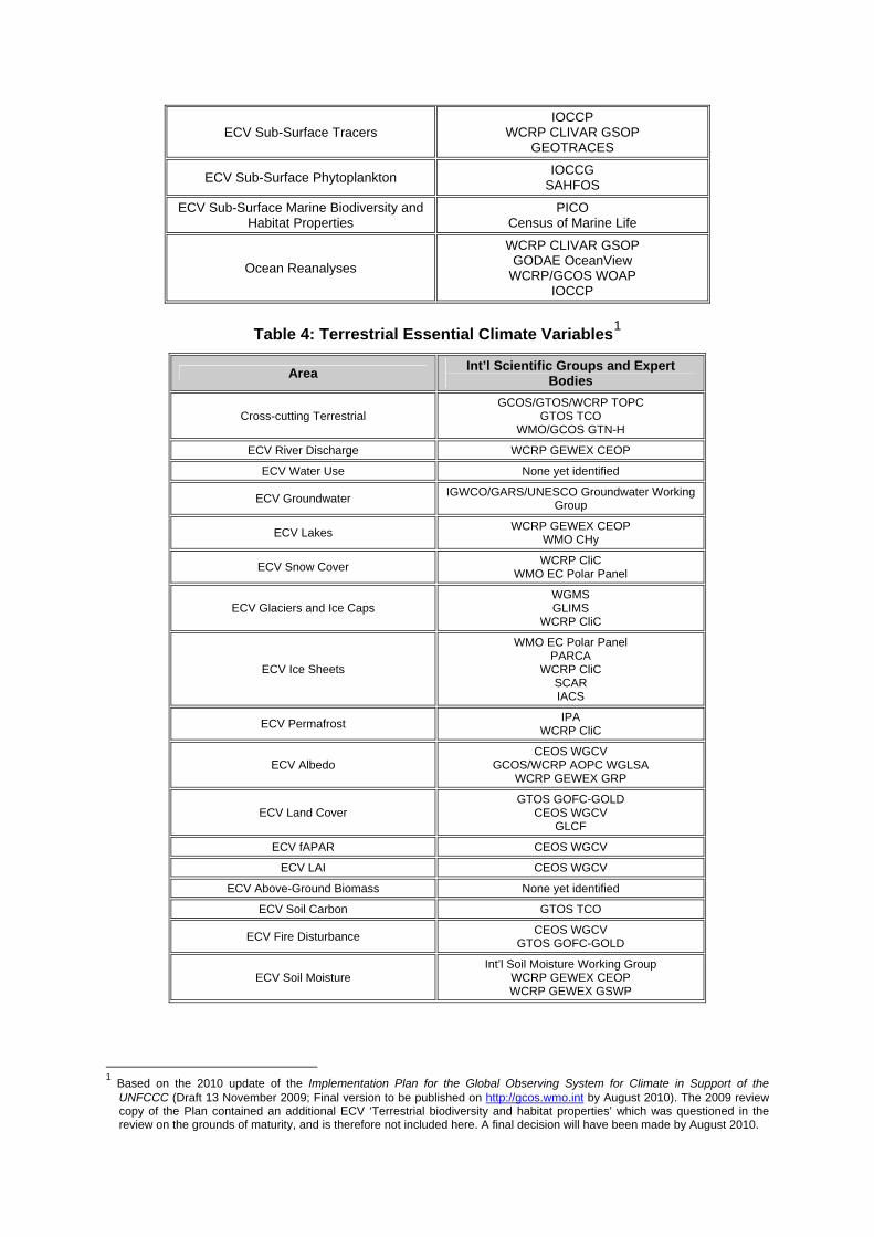
ECV Sub-Surface Tracers IOCCP
WCRP CLIVAR GSOP GEOTRACES
ECV Sub-Surface Phytoplankton IOCCG SAHFOS
ECV Sub-Surface Marine Biodiversity and Habitat Properties
PICO Census of Marine Life
Ocean Reanalyses
WCRP CLIVAR GSOP GODAE OceanView
WCRP/GCOS WOAP IOCCP
Table 4: Terrestrial Essential Climate Variables1
Area Int’l Scientific Groups and Expert Bodies
Cross-cutting Terrestrial GCOS/GTOS/WCRP TOPC
GTOS TCO WMO/GCOS GTN-H
ECV River Discharge WCRP GEWEX CEOP
ECV Water Use None yet identified
ECV Groundwater IGWCO/GARS/UNESCO Groundwater Working Group
ECV Lakes WCRP GEWEX CEOP WMO CHy
ECV Snow Cover WCRP CliC WMO EC Polar Panel
ECV Glaciers and Ice Caps WGMS GLIMS
WCRP CliC
ECV Ice Sheets
WMO EC Polar Panel PARCA
WCRP CliC SCAR IACS
ECV Permafrost IPA WCRP CliC
ECV Albedo CEOS WGCV
GCOS/WCRP AOPC WGLSA WCRP GEWEX GRP
ECV Land Cover GTOS GOFC-GOLD
CEOS WGCV GLCF
ECV fAPAR CEOS WGCV
ECV LAI CEOS WGCV
ECV Above-Ground Biomass None yet identified
ECV Soil Carbon GTOS TCO
ECV Fire Disturbance CEOS WGCV GTOS GOFC-GOLD
ECV Soil Moisture Int’l Soil Moisture Working Group
WCRP GEWEX CEOP WCRP GEWEX GSWP
1 Based on the 2010 update of the Implementation Plan for the Global Observing System for Climate in Support of the
UNFCCC (Draft 13 November 2009; Final version to be published on http://gcos.wmo.int by August 2010). The 2009 review copy of the Plan contained an additional ECV ‘Terrestrial biodiversity and habitat properties’ which was questioned in the review on the grounds of maturity, and is therefore not included here. A final decision will have been made by August 2010.
Glossary of Acronyms
ACC ATMOSPHERIC COMPOSITION CONSTELLATION (CEOS) AGG ADVISORY GROUP ON GSN AND GUAN (AOPC) AOPC ATMOSPHERIC OBSERVATION PANEL FOR CLIMATE ASPECT ANTARCTIC SEA ICE PROCESSES AND CLIMATE (WCRP CLIC, SCAR) BSRN BASELINE SURFACE RADIATION NETWORK CBS COMMISSION FOR BASIC SYSTEMS (WMO) CCl COMMISSION FOR CLIMATOLOGY (WMO) CEOP COORDINATED ENERGY AND WATER CYCLE OBSERVATIONS PROJECT
(WCRP) CEOS COMMITTEE ON EARTH OBSERVATION SATELLITES CIMO COMMISSION FOR INSTRUMENTS AND METHODS OF OBSERVATION
(WMO) CGMS COORDINATION GROUP FOR METEOROLOGICAL SATELLITES CHy COMMISSION FOR HYDROLOGY (WMO) CliC CLIMATE AND CRYOSPHERE PROJECT (WCRP) CLIVAR CLIMATE VARIABILITY AND PREDICTABILITY PROJECT (WCRP) DBCP DATA BUOY COOPERATION PANEL (JCOMM) EC EXECUTIVE COUNCIL (WMO) ECV ESSENTIAL CLIMATE VARIABLE ET-EGOS EXPERT TEAM ON THE EVOLUTION OF THE GLOBAL OBSERVING
SYSTEM (WMO CBS) FAPAR FRACTION OF ABSORBED PHOTOSYNTHETICALLY ACTIVE RADIATION FCDR FUNDAMENTAL CLIMATE DATA RECORD GAW GLOBAL ATMOSPHERE WATCH (WMO) GCMP GCOS CLIMATE MONITORING PRINCIPLE GCOS GLOBAL CLIMATE OBSERVING SYSTEM GEIA GLOBAL EMISSIONS INVENTORY ACTIVITY (IGBP IGAC) GEO GROUP ON EARTH OBSERVATIONS GEOSS GLOBAL EARTH OBSERVATION SYSTEM OF SYSTEMS GEOTRACES INTERNATIONAL STUDY OF THE GLOBAL MARINE BIOGEOCHEMICAL
CYCLES OF NUTRIENTS (SCOR) GEWEX GLOBAL ENERGY AND WATER CYCLE EXPERIMENT (WCRP) GHG GREENHOUSE GAS GHRSST GROUP FOR HIGH-RESOLUTION SEA-SURFACE TEMPERATURE GLCF GLOBAL LAND COVER FACILITY GLIMS GLOBAL LAND ICE MEASUREMENTS FROM SPACE INITIATIVE GLOSS GLOBAL SEA LEVEL OBSERVING SYSTEM GODAE GLOBAL OCEAN DATA ASSIMILATION EXPERIMENT GOFC-GOLD GLOBAL OBSERVATION OF FOREST AND LAND COVER DYNAMICS (GTOS) GOOS GLOBAL OCEAN OBSERVING SYSTEM GOS GLOBAL OBSERVING SYSTEM (WMO) GO-SHIP GLOBAL OCEAN SHIP-BASED HYDROGRAPHIC INVESTIGATIONS
PROGRAM (WCRP CLIVAR, IOCCP) GRP GEWEX RADIATION PANEL (WCRP) GSOP GLOBAL SYNTHESIS AND OBSERVATIONS PANEL (WCRP CLIVAR) GSWP GLOBAL SOIL WETNESS PROJECT (WCRP GEWEX) GTN-H GLOBAL TERRESTRIAL NETWORK FOR HYDROLOGY (WMO, GCOS) GTOS GLOBAL TERRESTRIAL OBSERVING SYSTEM IACS INTERNATIONAL ASSOCIATION OF CRYOSPHERIC SCIENCES ICSU INTERNATIONAL COUNCIL FOR SCIENCE IGAC INTERNATIONAL GLOBAL ATMOSPHERIC CHEMISTRY (IGBP) IGBP INTERNATIONAL GEOSPHERE-BIOSPHERE PROGRAMME IGOS INTEGRATED GLOBAL OBSERVING STRATEGY IGWCO INTEGRATED GLOBAL WATER CYCLE OBSERVATION THEME (IGOS)
IICWG INTERNATIONAL ICE CHARTING WORKING GROUP IMBER INTEGRATED MARINE BIODIVERSITY AND ECOSYSTEMS RESEARCH
(IGBP) IOC INTERGOVERNMENTAL OCEANOGRAPHIC COMMISSION (OF UNESCO) IOCCG INTERNATIONAL OCEAN COLOUR COORDINATING GROUP IOCCP INTERNATIONAL OCEAN CARBON COORDINATION PROJECT IPA INTERNATIONAL PERMAFROST ASSOCIATION IPWG INTERNATIONAL PRECIPITATION WORKING GROUP (CGMS) IROWG INTERNATIONAL RADIO OCCULTATION WORKING GROUP (CGMS) ITWG INTERNATIONAL TOVS WORKING GROUP (CGMS) IWWG INTERNATIONAL WINDS WORKING GROUP (CGMS) JCOMM JOINT TECHNICAL COMMISSION FOR OCEANOGRAPHY AND MARINE METEOROLOGY (WMO, IOC) LAI LEAF AREA INDEX NASA NATIONAL AERONAUTICS AND SPACE ADMINISTRATION (USA) OCR OCEAN COLOUR RADIOMETRY CONSTELLATION (CEOS) OOPC OCEAN OBSERVATIONS PANEL FOR CLIMATE OPACE OPEN PANEL OF CCL EXPERTS (WMO CCL) OST OCEAN SURFACE TOPOGRAPHY CONSTELLATION (CEOS) OSVW OCEAN SURFACE VECTOR WIND CONSTELLATION (CEOS) PARCA PROGRAM FOR ARCTIC REGIONAL CLIMATE ASSESSMENT PICO PANEL FOR INTEGRATED COASTAL OBSERVATIONS (GOOS) POGO PARTNERSHIP FOR OBSERVATION OF THE GLOBAL OCEANS SAG SCIENTIFIC ADVISORY GROUP SAHFOS SIR ALISTAIR HARDY FOUNDATION FOR OCEAN SCIENCE SCAR SCIENTIFIC COMMITTEE ON ANTARCTIC RESEARCH SCOR SCIENTIFIC COMMITTEE ON OCEANIC RESEARCH (ICSU) SMOS SOIL MOISTURE AND OCEAN SALINITY MISSION (ESA) SOOP SHIP OF OPPORTUNITY PROGRAMME (JCOMM) SPARC STRATOSPHERIC PROCESSES AND THEIR ROLE IN CLIMATE (WCRP) SST SEA-SURFACE TEMPERATURE TCO TERRESTRIAL CARBON OBSERVATION PANEL (GTOS) TIP TROPICAL MOORED BUOY IMPLEMENTATION PANEL TOPC TERRESTRIAL OBSERVATION PANEL FOR CLIMATE UNESCO UNITED NATIONS EDUCATIONAL, SCIENTIFIC AND CULTURAL
ORGANIZATION WCRP WORLD CLIMATE RESEARCH PROGRAMME WGARO WORKING GROUP ON ATMOSPHERIC REFERENCE OBSERVATIONS
(AOPC) WGCV WORKING GROUP ON CALIBRATION AND VALIDATION (CEOS) WGLSA JOINT WORKING GROUP ON LAND-SURFACE ATMOSPHERE ISSUES
(AOPC, TOPC) WGMS WORLD GLACIER MONITORING SERVICE WG-SP WORKING GROUP SURFACE PRESSURE (AOPC) WMO WORLD METEOROLOGICAL ORGANIZATION WOAP WCRP/GCOS OBSERVATION AND ASSIMILATION PANEL

Annex II
WORLD METEOROLOGICAL
ORGANIZATION INTERGOVERNMENTAL
OCEANOGRAPHIC COMMISSION
Guideline for the Generation of Datasets and Products
Meeting GCOS Requirements*
*An update of the “Guideline for the Generation of Satellite-based Datasets and Products meeting GCOS Requirements” (GCOS-128, WMO/TD-No. 1488),
including in situ datasets and amendments
May 2010
GCOS-143 (WMO/TD No. 1530)
UNITED NATIONS ENVIRONMENT PROGRAMME
INTERNATIONAL COUNCIL FOR SCIENCE
© World Meteorological Organization, 2010 The right of publication in print, electronic and any other form and in any language is reserved by WMO. Short extracts from WMO publications may be reproduced without authorization provided that the complete source is clearly indicated. Editorial correspondence and requests to publish, reproduce or translate this publication (articles) in part or in whole should be addressed to: Chairperson, Publications Board World Meteorological Organization (WMO) 7 bis, avenue de la Paix Tel.: +41 (0)22 730 84 03 P.O. Box No. 2300 Fax: +41 (0)22 730 80 40 CH-1211 Geneva 2, Switzerland E-mail: [email protected] NOTE The designations employed in WMO publications and the presentation of material in this publication do not imply the expression of any opinion whatsoever on the part of the Secretariat of WMO concerning the legal status of any country, territory, city or area or of its authorities, or concerning the delimitation of its frontiers or boundaries. Opinions expressed in WMO publications are those of the authors and do not necessarily reflect those of WMO. The mention of specific companies or products does not imply that they are endorsed or recommended by WMO in preference to others of a similar nature which are not mentioned or advertised. This document is not an official publication of WMO and has not been subjected to its standard editorial procedures. The views expressed herein do not necessarily have the endorsement of the Organization.
Guideline for the Generation of
Datasets and Products Meeting GCOS Requirements*
*An update of the “Guideline for the Generation of Satellite-based Datasets and Products meeting GCOS Requirements” (GCOS-128, WMO/TD-No. 1488),
including in situ datasets and amendments
May 2010
GCOS-143 (WMO/TD No. 1530)
1
Guideline for the Generation of Datasets and Products Meeting GCOS Requirements1
May 2010
1. Purpose of this Document This guideline is intended to help all producers of climate-relevant datasets (e.g., meteorological services, research institutions, oceanographic centres, environmental agencies, space agencies, universities) in the way they document, assess the quality of, and publicize their work related to the generation, processing and analysis of climate datasets and derived products (i.e. Fundamental Climate Data Records (FCDRs)2 and Essential Climate Variable products (ECV, cf. Annex I)), based on observations from surface-based, airborne and satellite-based instruments. Following this guideline would help to: • Facilitate the self-assessment of quality by data producers; • Ensure transparency in the generation of climate datasets and products; and thereby • Enable users to judge the quality and fitness for purpose of climate datasets and products. In addition, complying with this guideline can help producers of climate datasets and products to demonstrate that they aspire to address GCOS requirements for data quality, completeness and transparency. Nevertheless, following this guideline does not: • imply that those datasets and products necessarily attain climate standards for accuracy,
resolution and stability as stipulated by GCOS; • guide the operation of the observing networks and systems themselves that are the original
source of datasets in support of climate applications. Such guidance is provided by the internationally-adopted GCOS Climate Monitoring Principles, and adherence by observing system operators to these Principles greatly enhances the likelihood for obtaining climate-quality datasets from those systems (cf. Annex II);
• replace any obligations on data producers for quality assurance existing within their home institution, or for example within WMO or QA4EO guidelines (see section 3 for details).
2. Guideline General guidance for the generation of FCDRs and derived ECV products based on surface-based, airborne and satellite-based observing systems, and subsequent quality assessment by providers as well as users, is given by the GCOS requirements3 (e.g., for accuracy, stability, temporal/spatial resolution) as recommended in the GCOS Implementation Plan (and its 2010 update) and the Satellite Supplement4; these requirements are based on a broad consensus by the international climate community; and are reviewed on a regular basis.
1 An update of the Guideline for the Generation of Satellite-Based Datasets and Products Meeting GCOS Requirements,
GCOS-128 (WMO/TD-No. 1488), including in situ datasets and amendments 2 See section 4 for terminology. 3 The most recent version of the GCOS requirements can be found at
http://www.wmo.int/pages/prog/sat/Databases.html#UserRequirements (WMO/CEOS database) 4 Overview of all documentation related to GCOS needs given at:
http://www.wmo.int/pages/prog/gcos/index.php?name=ClimateObservationNeeds ; see ‘Background’ section for details
2
Specifically, to ensure full documentation, transparency and scientific stewardship in the generation (and update) of FCDRs and ECV products, the GCOS Steering Committee recommends that data producers pay particular attention to the following 12 needs5:
1. Full description of all steps taken in the generation of FCDRs and ECV products, including algorithms used, specific FCDRs used, and characteristics and outcomes of validation activities
2. Application of appropriate calibration/validation activities
3. Statement of expected accuracy6, stability and resolution (time, space) of the product, including, where possible, a comparison with the GCOS requirements
4. Assessment of long-term stability and homogeneity of the product
5. Information on the scientific review process related to FCDR/product construction (including algorithm selection), FCDR/product quality and applications7
6. Global coverage of FCDRs and products where possible
7. Version management of FCDRs and products, particularly in connection with improved algorithms and reprocessing
8. Arrangements for access to the FCDRs, products and all documentation
9. Timeliness of data release to the user community to enable monitoring activities
10. Facility for user feedback
11. Application of a quantitative maturity index if possible
12. Publication of a summary (a webpage or a peer-reviewed article) documenting point-by-point the extent to which this guideline has been followed
Experience with historical climate data records has shown that continuous, cyclical improvement of the quality of datasets and product is generally needed, since historical records usually have challenges in terms of homogeneity. An audit trail associated with climate data records is needed to document how such challenges have been met. A one-time assessment of quality/maturity of datasets and products must not preclude this improvement over time. 3. Background: Requirements and Guidance Formulation and regular review of requirements for observations-based climate datasets and products derived from those datasets in support of climate applications has been an ongoing activity under GCOS auspices8. In support of climate as well as of other application areas, the call has been repeatedly made by a number of international groups for adequate documentation, transparency and end-to-end scientific stewardship of observational datasets, ranging from their basic measurement to their use in analyses, reanalyses, models and other applications. 3.1. Background to GCOS Requirements The 2004 Implementation Plan for the Global Observing System for Climate in Support of the UNFCCC9 (GCOS-92, the ‘GCOS Implementation Plan’) identified 131 Actions required from many ‘Agents for Implementation’ to meet the needs for sustained, high-quality observations for the
5 These 12 needs should be addressed without prejudice to any other recommendations or obligations for quality assurance
within data producers’ home institutions or, for example, within WMO or QA4EO guidelines (see section 3 for details). 6 See section 4 for terminology. 7 This could be publications in peer-reviewed journals, or evaluations by independent, internationally-recognized science
groups. 8 Overview of all documentation related to GCOS needs given at:
http://www.wmo.int/pages/prog/gcos/index.php?name=ClimateObservationNeeds 9 GCOS (2004): Implementation Plan for the Global Observing System for Climate in Support of the UNFCCC, GCOS-92,
October 2004, http://www.wmo.int/pages/prog/gcos/Publications/gcos-92_GIP.pdf
3
purposes of the Convention. This implies the provision of climate-quality datasets and derived products addressing the Essential Climate Variables, variables for which observation is both feasible and relevant to the work of the IPCC and the UNFCCC. The GCOS Implementation Plan: • has led to the formulation of detailed observational requirements for all ECVs within the WMO
Rolling Review of Requirements process10. The requirements are inter alia expected also to cover the requirements of the World Climate Research Programme for long-term sustained observations;
• identified the need for proper data management and stewardship as critical activities to be undertaken in order to ensure that high-quality climate datasets are collected, retained and made accessible for analysis and/or reanalysis by current and future generations of scientists;
• stressed the importance of data exchange and comprehensive metadata accompanying the data in order to provide transparency for quality assessments (see e.g. Action C11).
In 2006, GCOS provided supplemental detail on the space-based requirements of the ‘GCOS Implementation Plan’) by issuing the document Systematic Observation Requirements for Satellite-based Products for Climate11 (GCOS-107, September 2006, hereafter called the ‘Satellite Supplement’). The Satellite Supplement stated requirements for datasets and products addressing 26 ECVs for which there is a major satellite observing component, as well as nine cross-cutting needs related to systematic observation of climate from space. The document indicated expected target accuracy, stability and resolution of ECV satellite products. It also included indications for the FCDRs required for the generation of products, relevant satellite instruments, necessary involvement of expert groups, supplemental needs for non-FCDR-type data records, and other application areas of ECV satellite products. As such, the Satellite Supplement by itself provides a substantial body of guidance for the generation of datasets and products that meet GCOS requirements. These requirements are reviewed by GCOS science panels on a regular basis, with involvement of relevant expert groups as appropriate. In addition, given the complexity of climate variability and, in part, limited knowledge of the expected variability of ECVs over space and time, several caveats apply to the use of requirements as such. For example, it is possible that a combination of data records from two satellite instruments, neither of which separately meet any of the requirements given in the Satellite Supplement, could usefully meet the needs for climate monitoring if applied together in careful analysis. The 2010 update of the GCOS Implementation Plan12 re-iterates and updates, as appropriate, the needs identified in the 2004 Plan. 3.2. Background to the Development of this Guideline The GCOS/WCRP Atmospheric Observation Panel for Climate, at its 13th session in April 2007, recognized that “it could be beneficial for GCOS to develop a process through which it might formally or informally recognize products that meet the requirements expressed in the Second Adequacy Report and the [GCOS] Implementation Plan. As an example, it was suggested that a data set might be formally recognized once it had been described in the peer-reviewed literature and made freely available to users.” The GCOS Steering Committee, at its 15th session in October 2007, requested “the GCOS Secretariat, in collaboration with the GCOS science panels, to develop guidelines for datasets and products meeting GCOS requirements, in response to the needs of […] space agencies.” In October 2008, the Committee “endorsed the approach taken in developing the guidelines [and] encouraged their use [..]. It also requested the GCOS Secretariat to expand the scope of the guidelines to in situ observations.” Based on the above requests, in March 2009, the GCOS Secretariat published the
10 The GCOS requirements in the WMO/CEOS database can be found at
http://www.wmo.int/pages/prog/sat/Databases.html#UserRequirements (February 2010) 11 GCOS (2006): Systematic Observation Requirements for Satellite-based Products for Climate – Supplemental details to the
satellite-based component of the GCOS Implementation Plan, GCOS-107, September 2006, http://www.wmo.int/pages/prog/gcos/Publications/gcos-107.pdf
12 Draft at the time of writing; Final version to be published on http://gcos.wmo.int by August 2010
4
Guideline for the Generation of Satellite-Based Datasets and Products Meeting GCOS Requirements (GCOS-128)13 which provides the basis for this expanded guideline. The need for guidelines to support a recognition process has been identified by space agencies, for example, in the context of the SCOPE-CM initiative (Sustained Coordinated Processing of Environmental Satellite Data for Climate Monitoring). It has also been expressed by producers of in situ datasets for climate, e.g. the scientific group maintaining the International Surface Pressure Databank. The ‘CIMO Guide’ (WMO, 2007a)14 provides guidance to measurement techniques for a range of meteorological variables from ground-based, airborne and space-based observing systems, and contains recommendations for quality management of observing systems, including metadata documentation. As noted in the GCOS Implementation Plan and the Satellite Supplement, observing systems should, for the purpose of climate monitoring and other climate applications, adhere to the GCOS Climate Monitoring Principles (see Annex II) to the greatest extent possible. Datasets obtained from such systems (ultimately, FCDRs) will be of enhanced value for monitoring the state of the Earth’s climate, through, for example, trend analyses, assimilation in climate models, use in reanalyses, and validation of model outputs. Observations coordinated by the WMO Global Atmosphere Watch programme address key ECVs related to atmospheric composition and fall under the WMO GAW quality assurance system15. The system has been set up to ensure that the data in the GAW World Data Centres are consistent, of known and adequate quality (including adherence to the GCOS Climate Monitoring Principles), supported by comprehensive metadata, and sufficiently complete to describe global atmospheric states with respect to spatial and temporal distribution. WMO (2007b)16 provides guidance to climate data management using standardized software tools which include the provision of minimum metadata. WMO (2003)17 makes recommendations on best practices in climate data management and homogenization, including required metadata, site documentation and data analysis tools, and WMO (2004)18 gives practical procedures for data rescue. Finally, the Guide to Climatological Practices (WMO, 2009)19 encompasses the full range of best practices in acquiring, handling and analyzing climate datasets.
The Quality Assurance framework for Earth Observation (QA4EO)20 has been developed as a contribution by space agencies, through CEOS, to the quality assurance strategy of the Global Earth Observation System of Systems (GEOSS). Based on the fundamental principle that "all Earth observation data and derived products should be associated with a documented and fully traceable quality indicator”, a set of guidance documents has been published with the aim to enable harmonization and interoperability of observing systems within GEOSS. While initially focusing on satellite-based data, contributions by national metrology institutes to QA4EO also reflect best practices of the non-space communities. Finally, the Open Archival Information System21 has provided guidance to space agencies on the set-up of data archive systems conforming to ISO standards. The checklist given in section 2 of this guideline represents a condensed synthesis of the existing body of guidance literature. It is recognized that, given the complexity of some ECV-related datasets and products, additional expertise and guidance may be needed for the generation of FCDRs and ECV satellite products, depending on the specifics of each case and application.
13 GCOS (2009) : Guideline for the Generation of Satellite-Based Datasets and Products Meeting GCOS Requirements,
GCOS-128 (WMO/TD-No. 1488), http://www.wmo.int/pages/prog/gcos/Publications/gcos-128.pdf 14 WMO (2007a): Guide to Meteorological Instruments and Methods of Observation (Seventh Edition), WMO-No. 8, 15 WMO (2007): WMO Global Atmosphere Watch (GAW) Strategic Plan: 2008-2015, WMO-GAW Report 172 (WMO/TD-No.
1384). ftp://ftp.wmo.int/Documents/PublicWeb/arep/gaw/gaw172-26sept07.pdf 16 WMO (2007b): Guidelines on Climate Data Management, WCDMP-60 (WMO/TD-No. 1376) 17 WMO (2003): Guideline on Climate Metadata and Homogenization, WCDMP-53 (WMO/TD-No. 1186) 18 WMO (2004): Guidelines on Climate Data Rescue, WCDMP-55 (WMO/TD-No. 1210) 19 WMO (2009): Guide to Climatological Practices. WMO-No. 100
http://www.wmo.int/pages/prog/wcp/ccl/guide/guide_climat_practices.html 20 http://qa4eo.org 21 http://en.wikipedia.org/wiki/Open_Archival_Information_System
5
4. Terminology Fundamental Climate Data Record (FCDR): In this document, the term “Fundamental Climate Data Record” (FCDR) is used to denote a long-term data record, generally involving a series of instruments (all platforms), with potentially changing measurement approaches, but with overlaps, calibration and quality control sufficient to allow the generation of homogeneous products providing a measure of the intended variable that is accurate and stable enough for climate monitoring. FCDRs include the ancillary data used to calibrate them. For “one-off” research-type measurements, the principles of continuity obviously do not apply, but as many of the other principles as possible (e.g., those for rigorous instrument characterization prior and during operations, complementarity of surface and satellite-based observations, etc.) should be followed. Product: The term "Product" denotes, in the context of this document, values or fields of Essential Climate Variables derived from FCDRs. Products may be generated by blending satellite observations and in situ data, or by blending multiple in situ or multiple satellite data sources. Some products are generated within model assimilation schemes. Some satellite-based products are created by using the laws of radiative transfer to retrieve ECVs from the FCDRs. Other documents use the term "Thematic Climate Data Record" (TCDR) 22 for such products; in the GCOS Implementation Plan, the term "integrated climate product" was used. The development of products may require strong collaboration between organizations responsible for the generation of datasets (e.g., meteorological services, oceanographic centres, environmental agencies, space agencies) and the separate research or operational groups that generate products, to ensure continuous refinement and extension. Adequate details of the product generation approach need to be documented and made available, along with the products, to ensure repeatability and incremental improvement of the products. Accuracy: Measured by the bias or systematic error of the data, i.e. the difference between the short-term average measured value of a variable and the true value. The short-term average is the average of a sufficient number of successive measurements of the variable under identical conditions, such that the random error is negligible relative to the systematic error. The latter can be introduced by instrument biases or through the choice of remote sensing retrieval schemes. Stability: The extent to which accuracy remains constant with time. Stability is measured by the maximum excursion of the short-term average (e.g., daily, monthly, seasonal) measured value of a variable under identical conditions over the long term, e.g. a decade. The smaller the maximum excursion, the greater the stability of the dataset. Horizontal resolution: Usually means sampling distance on the ground. In the case of satellite images, horizontal resolution means the image resolution. Vertical resolution: Vertical sampling distance or average spacing of independent pieces of information. Observing cycle: The required interval between two successive observations. For applications of global nature, this is the time needed for the whole Earth surface to be observed at least once within each grid square of size equal to the horizontal resolution and with the specified accuracy. Calibration: The process of quantitatively defining system responses to known, controlled signal inputs. Thus, a calibrated product is the output from the complete calibrated data generation chain. In the case of 22 For further discussion of the terms “Fundamental Climate Data Records (FCDRs)” and “Thematic Climate Data Records
(TCDRs)” see e.g. National Research Council (2004): Climate Data Records from Environmental Satellites, The National Academies Press, Washington D.C., USA, 150pp.
6
satellite-based measurements, vicarious calibration is indirect calibration achieved by simulating the signal at the satellite sensor input based on independently measured geophysical parameters, and comparing it to the actual signal measured by the sensor. The outcome of the comparison can be used to calibrate the sensor output. Validation: The process of assessing, by independent means, the quality of the data products derived from system outputs. Validation ensures that the quality of the products is properly assessed. In the case of satellite-based measurements, this is done via quantification of the uncertainties in Level 1b and Level 2 products. Thus, a validated product is the output from the complete validated data generation chain. Traceability: Refers to an unbroken chain of comparisons relating an instrument's measurement to a known standard. Calibration to a traceable standard can be used to determine an instrument's precision, accuracy and stability.
7
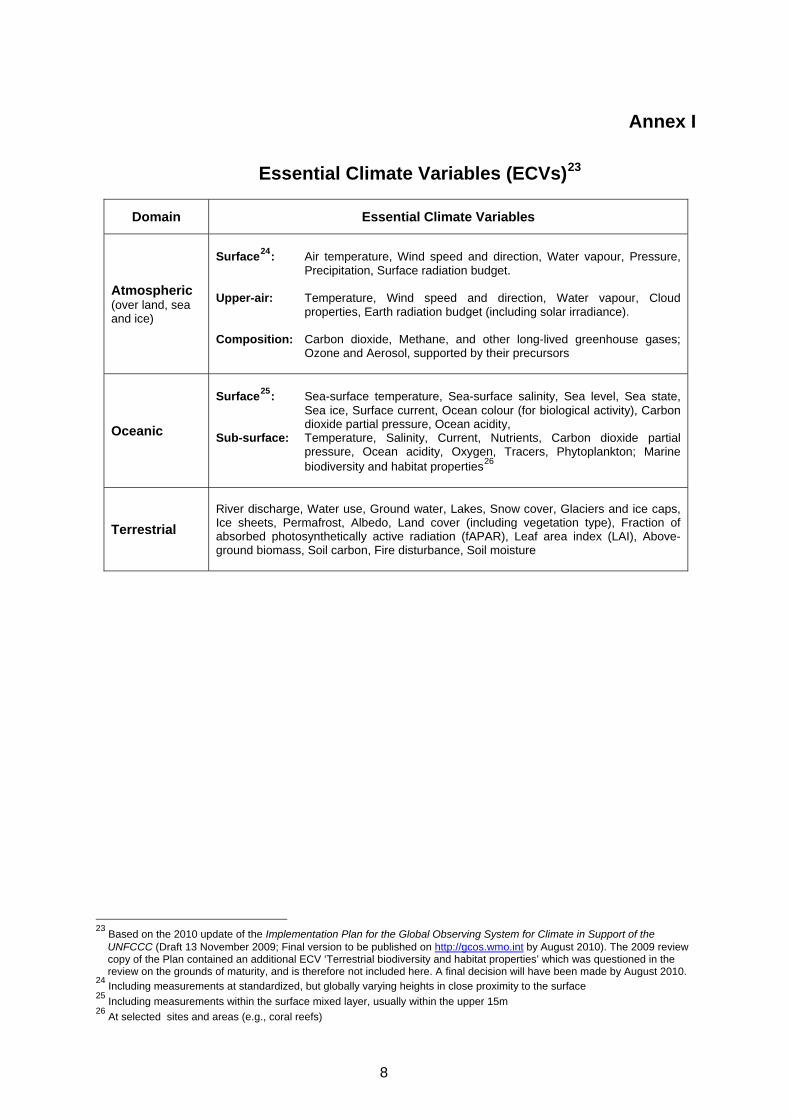
Annex I
Essential Climate Variables (ECVs)23
Domain Essential Climate Variables
Atmospheric (over land, sea and ice)
Surface24: Air temperature, Wind speed and direction, Water vapour, Pressure,
Precipitation, Surface radiation budget. Upper-air: Temperature, Wind speed and direction, Water vapour, Cloud
properties, Earth radiation budget (including solar irradiance). Composition: Carbon dioxide, Methane, and other long-lived greenhouse gases;
Ozone and Aerosol, supported by their precursors
Oceanic
Surface25: Sea-surface temperature, Sea-surface salinity, Sea level, Sea state,
Sea ice, Surface current, Ocean colour (for biological activity), Carbon dioxide partial pressure, Ocean acidity,
Sub-surface: Temperature, Salinity, Current, Nutrients, Carbon dioxide partial pressure, Ocean acidity, Oxygen, Tracers, Phytoplankton; Marine biodiversity and habitat properties26
Terrestrial
River discharge, Water use, Ground water, Lakes, Snow cover, Glaciers and ice caps, Ice sheets, Permafrost, Albedo, Land cover (including vegetation type), Fraction of absorbed photosynthetically active radiation (fAPAR), Leaf area index (LAI), Above-ground biomass, Soil carbon, Fire disturbance, Soil moisture
23 Based on the 2010 update of the Implementation Plan for the Global Observing System for Climate in Support of the
UNFCCC (Draft 13 November 2009; Final version to be published on http://gcos.wmo.int by August 2010). The 2009 review copy of the Plan contained an additional ECV ‘Terrestrial biodiversity and habitat properties’ which was questioned in the review on the grounds of maturity, and is therefore not included here. A final decision will have been made by August 2010.
24 Including measurements at standardized, but globally varying heights in close proximity to the surface 25 Including measurements within the surface mixed layer, usually within the upper 15m 26 At selected sites and areas (e.g., coral reefs)
8
Annex II
GCOS Climate Monitoring Principles (GCMPs) Effective monitoring systems for climate should adhere to the following principles 27: 1. The impact of new systems or changes to existing systems should be assessed prior to
implementation. 2. A suitable period of overlap for new and old observing systems is required. 3. The details and history of local conditions, instruments, operating procedures, data processing
algorithms and other factors pertinent to interpreting data (i.e., metadata) should be documented and treated with the same care as the data themselves.
4. The quality and homogeneity of data should be regularly assessed as a part of routine operations. 5. Consideration of the needs for environmental and climate-monitoring products and assessments,
such as IPCC assessments, should be integrated into national, regional and global observing priorities.
6. Operation of historically-uninterrupted stations and observing systems should be maintained. 7. High priority for additional observations should be focused on data-poor regions, poorly-observed
parameters, regions sensitive to change, and key measurements with inadequate temporal resolution.
8. Long-term requirements, including appropriate sampling frequencies, should be specified to
network designers, operators and instrument engineers at the outset of system design and implementation.
9. The conversion of research observing systems to long-term operations in a carefully-planned
manner should be promoted. 10. Data management systems that facilitate access, use and interpretation of data and products
should be included as essential elements of climate monitoring systems. Furthermore, operators of satellite systems for monitoring climate need to: (a) Take steps to make radiance calibration, calibration-monitoring and satellite-to-satellite cross-
calibration of the full operational constellation a part of the operational satellite system; and (b) Take steps to sample the Earth system in such a way that climate-relevant (diurnal, seasonal,
and long-term interannual) changes can be resolved. Thus satellite systems for climate monitoring should adhere to the following specific principles: 11. Constant sampling within the diurnal cycle (minimizing the effects of orbital decay and orbit drift)
should be maintained. 12. A suitable period of overlap for new and old satellite systems should be ensured for a period
adequate to determine inter-satellite biases and maintain the homogeneity and consistency of time-series observations.
27 The 10 basic principles (in paraphrased form) were adopted by the Conference of the Parties (COP) to the United Nations
Framework Convention on Climate Change (UNFCCC) through decision 5/CP.5 at COP-5 in November 1999. This complete set of principles was adopted by the Congress of the World Meteorological Organization (WMO) through Resolution 9 (Cg-XIV) in May 2003; agreed by the Committee on Earth Observation Satellites (CEOS) at its 17th Plenary in November 2003; and adopted by COP through decision 11/CP.9 at COP-9 in December 2003.
9
13. Continuity of satellite measurements (i.e. elimination of gaps in the long-term record) through appropriate launch and orbital strategies should be ensured.
14. Rigorous pre-launch instrument characterization and calibration, including radiance confirmation
against an international radiance scale provided by a national metrology institute, should be ensured.
15. On-board calibration adequate for climate system observations should be ensured and
associated instrument characteristics monitored. 16. Operational production of priority climate products should be sustained and peer-reviewed new
products should be introduced as appropriate. 17. Data systems needed to facilitate user access to climate products, metadata and raw data,
including key data for delayed-mode analysis, should be established and maintained. 18. Use of functioning baseline instruments that meet the calibration and stability requirements stated
above should be maintained for as long as possible, even when these exist on de-commissioned satellites.
19. Complementary in situ baseline observations for satellite measurements should be maintained
through appropriate activities and cooperation. 20. Random errors and time-dependent biases in satellite observations and derived products should
be identified.
GCOS Secretariat Global Climate Observing System
c/o World Meteorological Organization 7 bis, Avenue de la Paix
P.O. Box No. 2300 CH-1211 Geneva 2, Switzerland
Tel: +41 22 730 8275/8067 Fax: +41 22 730 8052
Email: [email protected]
10