Embed Size (px)
Citation preview
Recent Offshore Energy SEA funded projects
Since 1999, the UK’s Department for Business, Energy & Industrial Strategy and its forerunner departments (most recently the Department of Energy and Climate Change) has undertaken Strategic Environmental Assessment (SEA) in relation to Offshore Energy plans. The SEA programme has funded a significant number of marine surveys and research projects to improve the information base for undertaking strategic assessment and support activity specific consenting. The reports of, and data from, these studies are publicly available and deposited in the SEA data archive hosted by the British Geological Survey at http://www.bgs.ac.uk/data/sea/home.html, and the output from the most recent studies are available on the SEA pages of the gov.uk website. These most recent studies are tabulated below, arranged under 3 headings: Marine mammals (including noise), Birds, and Seabed and Water Column. A summary of the research, its status and a link to the project report (where published) are also provided. The authors and researchers involved in the SEA studies have been encouraged to submit papers for peer reviewed publication, and a list of recent publications related to each project is also provided.
Marine mammals (including noise)
Modelling of received sound levels by marine mammals during geophysical surveys (OESEA-17-78)
Project Ongoing
Project overview
As part of developing guidance on noise risk assessments for activities generating impulsive underwater noise, this modelling study aims to establish reliable expectations of sound exposure for a set of ‘typical’ seismic surveys, reflecting the most common combination of survey activity, location and duration on the UK continental shelf. The use of a soft-start as mitigation is assumed in each case and predictions are made with respect to thresholds for injury for all marine mammal functional hearing groups that may be regularly encountered (low, mid and high frequency cetaceans and seals).
Outputs
Research reports: Project in progress.
Seal habitat preference and distribution on west and north UK coasts (OESEA-16-76) SMRU
Project Ongoing
Project overview
This study includes a targeted programme of telemetry based grey seal tagging and spatial-temporal analyses of both grey seals (current deployment of 48 GPS/GSM tags) and harbour seals (previous deployment) high-resolution data.
Outputs
Research reports: Project in progress.
Offshore Energy SEA Research
October 2017
Behavioural responses by seals to offshore energy activities (OESEA-16-74) University of St. Andrews
Project Ongoing
Project overview
This project is a jointly funded (with the University of St Andrews) PhD studentship to investigate the behavioural responses of seals to a range of real and simulated anthropogenic sound sources, including tidal turbines, pile-driving and Acoustic Deterrent Devices (ADDs). The data have been already collected (high-resolution tagging data); the project is focussed on the analysis of individual movement patterns by seals in relation to estimated sound exposure.
Outputs
Research reports: Project in progress.
Analysis of seal behaviour at sea (OESEA-15-66) University of St Andrews
Project Completed
Project overview
High resolution GPS/GSM tags were deployed on 25 harbour seals and 20 grey seals in the southern North Sea to study animal activity budgets (resting, foraging and travelling intervals) at 2 hourly intervals. Data for 21 and 17 harbour and grey seals respectively was considered to be of sufficient quality to be used in the study. Activity budgets were defined within a Bayesian state-space model. Location data was treated both geographically (i.e. the recorded movements) and as the vector of seal speed and current speed to avoid potential misinterpretation of foraging and travelling behaviour due to tidal flow. Overall activity budgets were similar for harbour and grey seals with time divided approximately between resting (30%), foraging (45%) and travelling (25%). Significantly more time was spent foraging (at the expense of travelling) in hydro-space compared to geo-space, though note that for hydro-space there is an unknown error associated with the current data used. These activity budgets could serve as a baseline to the proportion of time in each state which can be compared with future telemetry data to determine any changes in foraging effort.
Outputs
Research reports: Russell DJF (2016). Activity budgets: analysis of seal behaviour at sea. Report for the Department for Business, Energy and Industrial Strategy, 21pp.
Analysis of impulsive sounds (OESEA-15-61) SMRU Ltd, with Cefas and University of Aberdeen
Project Ongoing
Project overview
It is common practice to compare predicted underwater sound exposure with predefined threshold criteria to assess the risk of injury from noise generating anthropogenic activities. Commonly adopted threshold criteria differentiate between impulsive and non-impulsive sounds, with impulsive sounds (e.g. seismic, piling) having a greater potential for auditory damage and behavioural response. However, over large distance, impulsive sounds may lose their impulsive characteristics with potential implications for impact assessment. A limiting factor in current understanding is the paucity of empirical data; to address this gap, this study uses previously recorded sounds to investigate how acoustic signals vary as a result of propagation effects.
Outputs
Research reports: Project in progress. Hastie G, Gotz T, Russell D, Janik VM, Thompson P & Merchant N (2017). Range dependent characteristics of impulsive sounds: implications for marine mammal behavioural responses and auditory damage. Report to BEIS.
Peer reviewed papers: in prep
Offshore Energy SEA Research
October 2017
Southern North Sea seal tagging (OESEA-14-47) and update to grey seal usage maps (OESEA-15-65) SMRU/University of St Andrews
Project Completed
Project overview
The project aim is to improve understanding of areas of grey seal usage in the southern North Sea where grey seal populations are rapidly increasing. Previous tagging data is sparse and old, and the foraging areas overlap with proposed offshore wind farm and gas field developments. 21 GPS/GSM tags were deployed on grey seals at Blakeney Point and at Donna Nook to provide improved understanding of transit routes, foraging areas, SAC haulout site fidelity, and interspecific interaction with harbour seals. Fieldwork was undertaken in May 2015. This work has also fed into a separate project to update grey seal usage maps, with data from the above tags and some additional tags deployed in eastern Scottish waters in 2013 being combined to provide data based on 175 tags spanning the years 1991-2015. When combined with 2014 population data, species distribution maps and confidence intervals were mapped on a 5x5km grid.
Outputs
Research reports: Russell DJF (2016). Movements of grey seal that haul out on the UK coast of the southern North Sea. Report for the Department of Energy & Climate Change, 18pp. Jones EL & Russell DJF (2016). Updated grey seal (Halichoerus grypus) usage maps in the North Sea. Report for the Department of Energy & Climate Change, 15pp.
Comparing the performance of Interim PCoD and the Moray Firth Seal Assessment Framework (OESEA-14-48) University of Aberdeen and others
Project Ongoing
Project overview
This study has used available data from intensively studied harbour seal populations (Moray Firth & the Wash) to compare the performance of two assessment frameworks under different development scenarios. A further element, a new expert elicitation exercise is being undertaken in 2017 to allow enhancement of the models.
Outputs
Research reports: Thompson P, Harwood J, Booth C, Hastie G & McLean N (2017). Comparing the performance of Interim PCoD and the Moray Firth Seal Assessment Framework. Report to BEIS
Tidal stream noise propagation (OESEA-13-42) SAMS (with University of Loughborough)
Project Completed
Project overview
From first principles, since sound velocity in water is high (1500 m/s) relative to tidal current velocity (max 4 m/s), flow should have negligible effect – however, field data indicate that this may not be the case with several possible influences identified e.g. effects of turbulence on absorption, vertical density stratification, topographic constraints. To test this, receiver stations and an acoustic source were set up in slack water with an intervening area of strong tidal flow in Falls of Lora, Connel, Argyll. Measurements were made at different tidal states (spring ebb, and slack neap) with peak flow measurements recorded at ~3m/s. Potential influences include basin shape, water column and sediment properties and water surface smoothness. Sound propagation was found to vary, with lower acoustic levels recorded during high tidal flow periods compared to low flow periods for frequencies in the 200Hz-6.3kHz range, with this observation gradually reversed for frequencies below 200Hz. Higher attenuation rates during higher flow periods for frequencies of interest were recorded, perhaps due to increased suspended sediment and entrained bubbles, as were higher background noise levels leading to lower source to background noise ratios. This may possibly be advantageous in terms of effects on hearing, but less so for avoidance of tidal structures.
Outputs
Research reports: Lepper PA, Elliot J, Benjamins S & Wilson B (2016). Variation in acoustic propagation across a tidal flow. SAMS and the University of Loughborough, 10pp.
Peer reviewed papers: in prep
Offshore Energy SEA Research
October 2017
Measuring fine scale marine mammal responses around an operational tidal turbine (OESEA-13-38) SMRU/SMRU Ltd.
Project Completed
Project overview
An understanding of marine mammal behaviour in the vicinity of tidal turbines is important in the prediction of potential impacts on individual species from the wider deployment of devices and arrays. Work to date by SMRU at the SeaGen tidal turbine, Strangford Lough, has sought to develop an active multibeam sonar system to detect the movement of marine mammals in proximity to the device. A range of systems were assessed during a DECC (now BEIS) funded study by SMRU (OESEA-11-23). As a result of this project, multibeam imaging sonar was trialled on SeaGen (see figure below) and capabilities for identifying marine mammals and tracking individuals around the turbine are much improved, but would benefit from validation by visual means or high resolution tagging. Operational licence conditions of the Strangford Lough turbine were such that the turbine was shut down when marine mammals are within 30m of the installation. The resulting data from the development of the active sonar system has been useful, but has not resolved the gap in understanding interactions of marine mammals with tidal turbines in continuous operation. In order to help fill this data gap and to further develop the active sonar system, permission was granted by the Northern Ireland Department of Environment Marine Division to temporarily suspend the shutdown protocol.
Outputs
The project main objectives could not be completed following the decision to decommission the tidal turbines. A paper “Behaviour of harbour seals (Phoca vitulina) around an operational tidal turbine” is in preparation.
Sonar detection of marine mammals (OESEA-11-23) SMRU Ltd.
Project Completed
Project overview
Currently, there is an information gap on the environmental impacts of tidal stream marine renewable energy devices on marine mammals (seals, whales and dolphins) as few of these devices have been installed in the sea. A principal environmental concern is the potential for physical injury to marine mammals through direct contact with rotating turbine blades and there is a need to improve understanding of this risk. The ability to detect and track marine mammals (or other large animals such as basking sharks) around devices would assist with such understanding. The information will aid environmental impact assessments and permitting decisions, including European Protected Species licensing and assessments of plans or projects under the Habitats Regulations. The four-phase project involved collaborations between marine mammal specialists, marine renewable developers, and sonar engineers to develop a user-friendly sonar system for the marine renewable industry. The four phases involved: Identification of the requirements of a generic sonar monitoring system for the renewable energy industry, Formal trials with captive seals to test the system prior to any further development and subsequent field deployment, Development and upgrading of selected system based on the findings of the previous phase, Upgraded sonar deployed on the SeaGen tidal turbine in Strangford Lough for a period of several months to evaluate the efficiency and reliability of the system. A secondary objective was to evaluate the frequency of encounters between marine mammals and the tidal turbine, and to measure potential behavioural responses to turbine operation.
Outputs
Research reports: Hastie GD (2012). Tracking marine mammals around marine renewable energy devices using active sonar. SMRU Ltd report URN:12D/328 to the Department of Energy and Climate Change, September 2012, 99pp.
Offshore Energy SEA Research
October 2017
Seal distribution and ecology (OESEA-10-10) SMRU/University of St Andrews
Project Completed
Project overview
SMRU holds a large database of telemetry data on grey and harbour seals (600 tags have been deployed on seals around the UK since 1988), which presented the opportunity to collate, analyse and interpret seal data for UK waters as a whole. Tagging has been carried out over various years, seasons, and regions and with animals of different ages and sexes. This tagging information represents one of the most comprehensive datasets for two seal species worldwide. The range of spatial, temporal, age and other data enabled a wide variety of analyses to be undertaken. The results provide baseline information and enhanced ecological understanding which in turn can inform conservation and development consenting decisions.
Outputs
Research reports: SMRU (2014). Seal at-sea distribution, movements and behaviour. Report to DECC by the Sea Mammal Research Unit, URN 14D/085, 25pp + appendices.
Peer reviewed papers: McClintock BT, Russell DJF, Matthiopoulos J & King R (2013). Combining individual animal movement and ancillary biotelemetry data to investigate population-level activity budgets. Ecology 94: 838-849. Russell DJ, McConnell BJ, Thompson D, Duck CD, Morris C, Harwood, J & Matthiopoulos J (2013). Uncovering the links between foraging and breeding regions in a highly mobile mammal. Journal of Applied Ecology 50: 499-509. Russell DJF, McClintock BT, Matthiopoulos J, Thompson PM, Thompson D, Hammond PS, Jones EL, MacKenzie ML, Moss S & McConnell BJ (2015). Intrinsic and extrinsic drivers of activity budgets in sympatric grey and harbour seals. Oikos 124: 1462–1472. Jones EL, McConnell BJ, Smout S, Hammond PS, Duck CD, Morris CD, Thompson D, Russell DJF, Vincent C, Cronin M, Sharples RJ & Matthiopoulos J (2015). Patterns of space use in sympatric marine colonial predators reveal scales of spatial partitioning. Marine Ecology Progress Series 534: 235–249.
The effects of wind farm construction and operation on harbour seals in the south western North Sea (OESEA-11-24) SMRU/University of St Andrews
Project Completed
Project overview
Seals have sensitive low- to mid-frequency hearing (50Hz to 86kHz) which overlaps much of the sound generated during wind farm construction (e.g. pile-driving) and operation and therefore makes them potentially susceptible to behavioural disturbance as well as auditory damage. Impulsive underwater sounds during pile-driving have the potential to elicit strong behavioural reactions which may affect foraging behaviour and location but it is currently not known how long such effects will persist. There are also concerns that marine mammals may avoid operational wind farms because of the low intensity but continuous noise associated with arrays of functioning turbines. Alternatively, they may be attracted to wind farms if any ‘reef effect’ enhances local fish abundance. The Wash in south east England is an area of past and current wind farm construction and also an internationally important area (Special Area of Conservation) for harbour seals, with their historic foraging areas overlapping with wind farms and therefore ideal to study the response of seals to wind-farm developments from tagging data. The 2012 project built on baseline data collected between 2003 and 2006 largely with DECC (now BEIS) SEA funding and worked alongside a complimentary project in the Thames Estuary (supported by Zoological Society of London). Since the original tagging studies wind farm construction has taken place in the southern North Sea, largely within territorial waters, which are used by the study animals. Additional wind farms located further offshore have also been consented or are under construction.
Offshore Energy SEA Research
October 2017
Outputs
Peer reviewed papers: Russel DJF, Brasseur SMJM, Thompson D, Hastie GD, Janik VM, Aarts G, McClintock BT, Matthiopoulos J, Moss S & McConnell B (2014). Marine mammals trace anthropogenic structures at sea. Current Biology 24: R638-R639. Hastie GD, Russell DJF, McConnell B, Moss S, Thompson D & Janik VM (2015). Sound exposure in harbour seals during the installation of an offshore wind farm: predictions of auditory damage. Journal of Animal Ecology 52: 631–640. Hastie GD, Russell DJF, McConnell BJ, Thompson D & Janik VM (2016). Multiple-pulse sounds and seals: results of a harbour seal (Phoca vitulina) telemetry study during windfarm construction. Advances in Experimental Medicine and Biology 875: 425-430. Russell DJF, Hastie GD, Thompson D, Janik V, Hammond P, Scott-Hayward L, Matthiopoulos J, Jones E & McConnell B (2016). Avoidance of windfarms by harbour seals is limited to pile driving activities. Journal of Applied Ecology 53: 1642-1652.
Lucke K, Hastie GD, Ternes K, McConnell B, Moss S, Russel DJ, Weber H & Janik VM (2016). Aerial low‑
frequency hearing in captive and free‑ranging harbour seals (Phoca vitulina) measured using auditory
brainstem responses. Journal of Comparative Physiology A 202: 859-868.
A study to assess cetacean behavioural responses to pile-driving (OESEA-11-29) University of Aberdeen
Project Completed
Project overview
There is limited information on the scale at which marine mammals may be disturbed by pile-driving or other anthropogenic noise, with previous assessments highlighting the need for more data on the duration of displacement following pile-driving activity. This information is important for determining whether intermittent pile-driving can lead to either intermittent or complete exclusion of animals from the area during a construction period. Such information will help further inform environmental impact assessment at a strategic and project level.
This project built on DECC (now BEIS) and industry funded studies in the Moray Firth which have provided significant baseline data on the occurrence of marine mammals in the area and their responses to sound sources from 2 seismic surveys. The original scope of this study was to assess marine mammal responses to piling during the installation of a meteorological mast within a Moray Firth wind farm development zone. Since the met mast installation did not proceed, the study used the development of the Nigg Energy Park to assess responses of both bottlenose dolphins and harbour porpoises to piling activity (both impact and vibropiling) during jetty construction over the winter of 2013/14.
Outputs
Peer reviewed papers: Graham IM, Pirotta E, Merchant ND, Farcas A, Barton T, Cheney B, Hastie GD & Thompson PM (2017). Responses of bottlenose dolphins and harbour porpoises to impact and vibration piling noise during harbour construction. Ecosphere 8: 1-16, Farcas A, Thompson PM & Merchant ND (2016). Underwater noise modelling for environmental impact assessment. Environmental Impact Assessment Review 57: 114-122.
SCANS-III Planning Support (OESEA-11-30) SMRU/University of St Andrews
Project Completed
Project overview
SCANS-III builds on previous large scale cetacean surveys beginning in 1994 (Small Cetaceans in European Atlantic waters and the North Sea, SCANS) and followed by SCANS II (2005) and CODA (2007). The Department provided staff in order to facilitate the planning and European partner alignment for 3rd SCANS survey. Surveys were successfully conducted in 2016 in order to meet the objective of estimating the abundance of all cetacean species in shelf and oceanic waters of the European Atlantic continental shelf, and results are available from the SCANS-III website.
Outputs
SCANS-III website: http://synergy.st-andrews.ac.uk/scans3/
Offshore Energy SEA Research
October 2017
The eastern Scotland bottlenose dolphin population: Improving understanding of ecology outside the Moray Firth SAC to inform marine energy consenting decisions (OESEA-11-31, OESEA-14-44) University of St Andrews
Project Completed
Project overview
A small, seemingly resident population of bottlenose dolphins Tursiops truncatus exists off the east coast of Scotland. They typically range from coastal waters of the Moray Firth to the Firth of Forth, with occasional observations from further offshore in the North Sea; the dolphins are most frequently sighted within the inner Moray Firth and this has been an area of focus for bottlenose dolphin research, with former studies funded by DECC (now BEIS), and undertaken by SMRU, University of Aberdeen, SNH and others. Sighting histories of individual animals were constricted using photo-identification of long-lasting natural marks. Animals are known to range along the east coast but there is much spatial and temporal variability between individuals. Dolphins were encountered more often in and around the Tay estuary in waters less than 20m and within 2km of the coast. Encounter rates were consistently high in the Tay, with 2009-13 estimates representing approximately 35-46% of the Scottish east coast population. Dolphins were also frequently encountered along the coast between Montrose and Aberdeen, with an estimated 25% of the population occurring between Stonehaven and Aberdeen, and >60% using the area between the Firth of Forth and Aberdeen in 2012 and 2013. The project sought to improve the understanding of the distribution and abundance of bottlenose dolphin outside of the Moray Firth and of the ecology of the population throughout its range, such that the results of the study will contribute to informing offshore energy consenting decisions.
Outputs
Research reports: Quick N, Arso M, Cheney B, Islas V, Janik V, Thompson PM & Hammond PS (2014). The east coast of Scotland bottlenose dolphin population: improving understanding of ecology outside the Moray Firth SAC. Document produced as part of UK Department of Energy and Climate Change’s offshore energy Strategic Environmental Assessment Programme, URN 14D/086, 87pp.
Birds
Cross-validation of at-sea survey and GPS tracking methods to determine marine distribution of seabirds (OESEA-15-54) RSPB
Project Ongoing
Project overview
Comparison of estimates derived from at-sea survey and GPS tracking data, to determine: 1. whether there is broad agreement in the patterns of distribution and densities estimated from the two methods 2. causes of any discrepancies in distribution estimates 3. whether the inability to conduct survey in sea states greater than F4 lead to bias in measured distributions, due to birds favouring sheltered locations, or spending more time at the colony or on the water surface than in flight, during poor weather 4. whether inability to conduct at-sea survey during the night leads to seriously biased estimates of marine distribution during the entire 24 hour cycle. The analyses are of RSPB 2015 collected tracking data from razorbill and guillemots breeding on the Shiant Isles, and simultaneous surveys in the waters of the Minch surrounding the breeding colony.
Outputs
Research reports: In prep
Offshore Energy SEA Research
October 2017
High resolution tagging of gannets (OESEA-14-46) University of Leeds
Project Completed
Project overview
This project is a follow-on piece of work to previous University of Leeds (OESEA-13-41) and RSPB (OESEA-11-27) tagging studies to allow improved collision risk modelling. The foraging behaviour of birds remains a key data gap in the assessment of potential effects of offshore wind farms. The study tagged 35 adult gannets (129 foraging trips for 31 birds were received, also note pressure loggers were also added to some adults) and 22 immature gannets (118 foraging trips for 15 birds were received) from the Bass Rock colony between June and August 2015. The data received provided information on bird behaviour (foraging, distribution) and time spent within proposed wind farm sites. Differences between adult and immature birds and between sexes were observed but were considered minor such that similar potential collision risks could be considered for each, that is that the greatest risk to collision is likely to be during periods of active foraging. Further research is required on immature birds, including flight heights, wind turbine avoidance rates and numbers of immature birds attending colonies.
Outputs
Research reports: Hamer KC, Gecian WJ & Lane J (2016). Fine-scale foraging behaviour of adult and immature northern gannets: distributions, movements and potential interactions with offshore wind-farms. University of Leeds, 23pp.
Gannet flight behaviour (OESEA-13-41) University of Leeds
Project Completed
Project overview
In order to assess potential collision risks, and other impacts, e.g. displacement, from the construction offshore wind farms, and therefore also the potential for effects on individuals, populations and the status of any related conservation sites, data on flight heights and tracks of relevant birds are required. Large colonies of northern gannets are present in relatively close proximity to several proposed offshore wind sites, or within foraging range of these sites.
This project extends a NERC-funded study carried out over the summers of 2010-2012 where GPS tracks of gannets foraging from Bass Rock were collected. While GPS loggers accurately recorded location in the horizontal plane, errors associated with height estimates were large and unpredictable. Therefore, during the 2010-2012 study, a bird-borne pressure logger was trialled (11 in 2011 and 5 in 2012) on a subset of tagged birds with a view to using the barometric technique to estimate flight height more accurately; such loggers have had previous success recording the flight heights of other birds (e.g. red-footed boobies and frigate birds) whereby altitude was derived from the pressure difference between a sea-level weather station and the logger. The work was intended as a proof of concept study to determine that accurate three dimensional foraging data could be collected. It was found that during commuting to foraging areas, birds flew at a median height of 12m, which increased to 27m during active foraging, therefore collision risk may differ depending on which of these behaviours is being exhibited.
Outputs
Peer reviewed papers: Cleasby IR, Wakefield ED, Bearhop S, Bodey TW, Votier SC & Hamer KC (2015). Three-dimensional tracking of a wide-ranging marine predator: flight heights and vulnerability to offshore wind farms. Journal of Applied Ecology 52: 1474-1482.
Offshore Energy SEA Research
October 2017
Foraging ranges of northern gannets Morus bassanus in relation to proposed offshore wind farms in the UK 2010-2012 (OESEA-11-27) RSPB
Project Completed
Project overview
Britain and Ireland are of outstanding international importance for their breeding seabirds for which they host a high proportion of the biogeographical populations of several species, one of which is the northern gannet (Morus bassanus). The UK hosts approximately 59% of the world population of gannets at colonies distributed mainly around the western and northern coasts of Britain. The only gannet colony in England is at Flamborough Head and Bempton Cliffs, a Special Protection Area (SPA) that includes gannet as part of the breeding seabird assemblage that forms a qualifying feature of the site. Gannets may be vulnerable to collision with offshore wind turbines; they have poor manoeuvrability and their long, narrow wings and high wing-loading (wing loading is the ratio of weight to wing area) are adaptations to using the wind to assist fast flight. The risk with wind farms is unclear, with it depending on levels of flight activity within the wind farm footprints and within the rotor swept area and extent of avoidance behaviour. It is known that gannets fly at and plunge-dive from elevations within rotor swept height.
The three seasons of study, in 2010 (n=14 birds), 2011 (n=13) and 2012 (n=15), have identified the previously unknown sea areas used by adult gannets from Bempton Cliffs. Locations during the three chick-rearing periods show a marked similarity in the area of active use, but a notable difference in the extent of the core area used in 2012. Distance to colony had the over-riding influence on foraging range. Relatively small annual samples mean that we remain unsure how representative the data are of year to year foraging activity by breeding gannets from Bempton Cliffs, especially in years of lower breeding productivity. However, the collective foraging range of the forty two tagged birds encompassed the full seaward radius around Bempton Cliffs such that the results represent the sea areas used by adult gannets, at least in seasons of good breeding productivity. Approximately 70% of foraging trips were within 50 km of Bempton Cliffs (mean range all three years, 43.0 ± SD 49.1km, range 5-404km, n=2,721 trips), only 25 exceeding 200km, of which just two exceeded 300km.
Outputs
Research reports: RSPB (2011). Foraging ranges of northern gannets Morus bassanus in relation to proposed offshore wind farms in the UK. RSPB Report to DECC, URN 11D/845, 19pp. RSPB (2012). Foraging ranges of northern gannets Morus bassanus in relation to proposed offshore wind farms in the UK: 2011. RSPB Report to DECC, URN 12D/315, 29pp. RSPB (2013). Foraging ranges of northern gannets Morus bassanus in relation to proposed offshore wind farms in the UK: 2010-2012. RSPB Report to DECC, URN 13D/306, 74pp.
Peer reviewed papers: Wakefield ED, Bodey TW, Bearhop S, Blackburn J, Colhoun K, Davies R, Dwyer RG, Green J, Grémillet D, Jackson AL, Jessopp MJ, Kane A, Langston RHW, Lescroël A, Murray S, Le Nuz M, Patrick SC, Péron C, Soanes L, Wanless S, Votier SC & Hamer KC (2013). Space partitioning without territoriality in gannets. Science 341: 68-70.
Offshore Energy SEA Research
October 2017
High resolution tagging of west coast Lesser black backed gulls (OESEA-15-50) BTO
Project Ongoing
Project overview
This study is the second phase of the work initiated with project OESEA-13-40. The research involves fieldwork, data recovery, analyses and reporting for lesser black-backed gulls fitted with Amsterdam GPS tags at Skokholm and South Walney for a second breeding season (2015) and two non-breeding seasons (2014/15 and 2015/16); and fieldwork data recovery, analyses and reporting for herring gulls fitted with Pathtrack GPS tags at South Walney for a second breeding season (2015) and two non-breeding seasons (2014/15 and 2015/16).
Outputs
Peer reviewed papers: Ross-Smith V, Thaxter C, Clark N, Shamoun-Baranes J, Bouten W & Burton N (2016). GPS telemetry reveals differences in the foraging ecology of breeding lesser black-backed gulls between three Special Protection Area colonies. BOU Proceedings – Birds in time and space: avian tracking and remote sensing. Ross-Smith V, Thaxter CB, Masden EA, Shamoun-Baranes J, Burton NHK, Wright LJ, Rehfisch MM & Johnston A (2016). Modelling flight heights of lesser black-backed gulls and great skuas from GPS: a Bayesian approach. Journal of Applied Ecology 53: 1635-1891. Thaxter CB, Ross-Smith VH, Clark NA, Bouten W & Burton NHK (2015). GPS telemetry reveals within-wind farm behavior of lesser black-backed gulls during the breeding season. In: Köppel J & Schuster E (eds.) Book of Abstracts (page 65). Conference on Wind energy and Wildlife impacts (CWW 2015), March 10-12, 2015. Berlin, Germany. Thaxter CB (2017). Chapter 15: Tracking and telemetry of marine birds. In: Perrow, M. (ed.) Wildlife and Wind Farms: Offshore Volume 2: Conflicts and Solutions. Conservation Handbooks. Pelagic Publishing.
Tagging of Lesser black backed gulls (OESEA-13-40 and OESEA-13-40Var1) BTO
Project Completed
Project overview
Building on earlier BTO work (OESEA-11-28) 30 tags were fitted to Lesser black backed gulls on Skomer/Skokholm and Walney Islands to obtain data on migration routes and flying heights in different conditions.
Outputs
Peer reviewed papers: Thaxter CB, Ross-Smith VH, Clark JA, Clark NA, Conway GJ, Marsh M, Leat EHK & Burton NHK (2014). A trial of three harness attachment methods and their suitability for long-term use on lesser black-backed gulls and great skuas. Ringing & Migration 29: 65-76. Ross-Smith V, Thaxter C, Clark N, Shamoun-Baranes J, Bouten W & Burton N (2016). GPS telemetry reveals differences in the foraging ecology of breeding lesser black-backed gulls between three Special Protection Area colonies. BOU Proceedings – Birds in time and space: avian tracking and remote sensing. Ross-Smith V, Thaxter CB, Masden EA, Shamoun-Baranes J, Burton NHK, Wright LJ, Rehfisch MM & Johnston A (2016). Modelling flight heights of lesser black-backed gulls and great skuas from GPS: a Bayesian approach. Journal of Applied Ecology 53: 1635-1891. Thaxter CB, Ross-Smith VH, Clark NA, Bouten W & Burton NHK (2015). GPS telemetry reveals within-wind farm behavior of lesser black-backed gulls during the breeding season. In: Köppel J & Schuster E (eds.) Book of Abstracts (page 65). Conference on Wind energy and Wildlife impacts (CWW 2015), March 10-12, 2015. Berlin, Germany. Thaxter CB (2017). Chapter 15: Tracking and telemetry of marine birds. In: Perrow, M. (ed.) Wildlife and Wind Farms: Offshore Volume 2: Conflicts and Solutions. Conservation Handbooks. Pelagic Publishing.
Offshore Energy SEA Research
October 2017
Measuring the interaction between marine features of Special Protection Areas with offshore wind farm development sites through telemetry (OESEA-11-28) BTO
Project Completed
Project overview
Potential areas for development of offshore wind farms include locations that may hold large numbers of seabirds, seaduck and other waterbirds. Both consented and proposed development sites within the North Sea may also overlap the foraging areas of seabirds that are features of protected sites. Offshore wind farms may potentially have an impact on these bird populations through four main effects: (1) displacement due to the disturbance associated with developments; (2) the barrier effect posed by developments to migrating birds and birds commuting between breeding sites and feeding areas; (3) collision mortality; (4) indirect effects due to changes in habitat or prey availability.
In summer 2011, GPS tags were fitted to 14 lesser black-backed gulls at Orford Ness, part of the Alde-Ore Estuary SPA. This was in addition to 11 birds tagged at this site in 2010. Following the tagging of four great skuas on the Foula SPA in Shetland in 2010, a further 10 birds were tagged in 2011. Ten great skuas were also tagged on the Hoy SPA in the Orkney archipelago. All individuals tagged were members of breeding pairs, and were caught on the nest. In summer 2012, 17 GPS-tagged lesser black-backed gulls returned to breed at Orford Ness (Alde-Ore Estuary SPA), including all 14 tagged in 2011 and three tagged in 2010. Only one tagged great skua returned to the Foula and Hoy breeding colonies in 2012, and this bird had lost its tag and harness, whereas a control group for skuas at both colonies showed a high return rate. No adverse effect had been seen during the 2011 breeding season, but clearly the attachment of the tags caused an adverse effect over the migration/winter period. While it is conceivable that the remaining tagged skuas just skipped a breeding attempt, this is considered unlikely. Consequently, the skua study was immediately terminated. In total 13% of the 2,717 trips recorded in 2012 for lesser black-backed gulls contained a marine component. The maximum foraging range offshore in 2012 during breeding was 159km. Some individual gulls never ventured offshore, whilst others spent a substantial amount of time away from the colony at sea. The proportion of birds that used areas of operational, consented and proposed offshore wind farm areas was highest in 2010 (70% of 10 birds), similar in 2011 (78% of 18 birds) and lowest in 2012 (57% of 14 birds), however despite these high numbers of encounters, time spent in each wind farm area was relatively low (peaking at 4% in 2010) and area usage was 14% for the same year. For lesser black-backed gulls, the use of offshore areas and thus of the areas of operational, consented and proposed offshore wind farms during the breeding season (covering the pre-breeding, breeding and post-breeding periods) showed (1) individual, (2) seasonal, (3) sex-specific and (4) annual variations. Annual differences in the use of wind farm areas is such that tracking birds over longer periods may be necessary to avoid incorrect estimates of the level of risk to seabirds, additionally, the work also indicated it would be useful to investigate other populations of lesser black-backed gulls from other SPAs, and also migration strategies, or the exposure of other migratory species to offshore wind farms outwith the breeding season.
Outputs
Research reports: Thaxter CB, Ross-Smith VH, Clark NA, Conway GJ, Rehfisch MM, Bouten W & Burton NHK (2011). Measuring the Interaction Between Marine Features of Special Protection Areas with Offshore Wind Farm Development Sites Through Telemetry: first breeding season report. BTO Research Report No. 590. Thetford, Norfolk. URN 11D/846, 70pp. Thaxter CB, Ross-Smith VH, Clark NA, Conway GJ, Wade H, Masden EA, Rehfisch MM, Bouten W & Burton NHK (2012). Measuring the Interaction Between Marine Features of Special Protection Areas with Offshore Wind Farm Development Sites Through Telemetry: second breeding season report. BTO Research Report No. 610, 50pp. Thaxter CB, Ross-Smith VH, Johnston A, Clark NA, Conway GJ, Wade H, Masden EA, Bouten W & Burton NHK (2013). Measuring the Interaction Between Marine Features of Special Protection Areas with Offshore Wind Farm Development Sites Through Telemetry: third year report. BTO Research Report No. 639, 42pp. Thaxter CB, Ross-Smith VH, Clark NA, Conway GJ, Johnston A, Wade H, Masden EA, Bouten W & Burton NHK (2014). Measuring the Interaction Between Marine Features of Special Protection Areas with Offshore Wind Farm Development Sites Through Telemetry: Final Report. BTO Research Report No. 649, 183pp.
Offshore Energy SEA Research
October 2017
Measuring the interaction between marine features of Special Protection Areas with offshore wind farm development sites through telemetry (OESEA-11-28) BTO
Project Completed
Peer reviewed papers: Thaxter C, Ross-Smith V, Burton N, Wade H, Masden E & Bouten W (2013). Connectivity between seabird features of protected sites and offshore wind farms: lesser black-backed gulls and great skuas through breeding, migration and non-breeding seasons. BOU proceedings – Marine Renewables and Birds. Thaxter CB, Ross-Smith VH, Bouten W, Clark NA, Conway GJ, Rehfisch MM & Burton NHK (2015). Seabird-wind farm interactions during the breeding season vary within and between years: A case study of lesser black-backed gull Larus fuscus in the UK. Biological Conservation 186: 347-358. Thaxter CB, Ross-Smith VH, Clark JA, Clark NA, Conway GJ, Masden EA, Wade HM, Leat EHK, Gear SC, Marsh M, Booth C, Furness RW, Votier SC & Burton NHK (2016). Contrasting effects of GPS device and harness attachment on adult survival of lesser black-backed gulls Larus fuscus and great skuas Stercorarius skua. Ibis doi: 0.1111/ibi.12340. Ross-Smith V, Thaxter C, Clark N, Shamoun-Baranes J, Bouten W & Burton N (2016). GPS telemetry reveals differences in the foraging ecology of breeding lesser black-backed gulls between three Special Protection Area colonies. BOU Proceedings – Birds in time and space: avian tracking and remote sensing. Wade HM, Masden EA, Jackson AC, Thaxter CB, Burton NHK, Bouten W & Furness RW (2014). Great skua (Stercorarius skua) movements at sea in relation to marine renewable energy developments. Marine Environmental Research 101: 69-80.
High resolution tagging of Bewick’s swans (OESEA-12-35 and OESEA-14-49) WWT
Project Completed
Project overview
The movement of several swan and goose populations along coastal Britain and through Scotland has been described through satellite-tracking studies undertaken by WWT under contract to COWRIE Ltd. and to DECC (now BEIS), and these have highlighted key areas where the construction of offshore wind farms may pose a risk to these birds, particularly for whooper swans migrating to Iceland and for Barnacle Geese that cross the North Sea to Norway en route to breeding grounds on Svalbard (see: Griffin et al. 2011). Much less is known, however, about flight-lines taken by birds migrating between southeast England and the Low Countries of Continental Europe. Further satellite-tracking of bird migration was therefore recommended to clarify potential effects of wind farm development for birds moving across this part of the North Sea. Additionally, tracking migratory birds that winter at inland sites helps to identify those designated as Special Protection Areas (SPAs) under EU legislation that may be affected by offshore wind development, which should therefore be taken into account in Scoping Reports and Environmental Impact Assessments on considering the likely significant effects (LSE) of a wind farm on SPAs. Without such studies, the link between inland SPAs and offshore wind farm development would be less well understood. From winter 2013/14 onwards, the Wildfowl & Wetlands Trust tracked Bewick’s swan movements in relation to offshore and onshore wind farms along their migration route, with a particular focus on the birds’ flight-paths between Britain and mainland Europe. Eight swans were tagged in the winter of 2013/14 (though some tags had a software problem limiting their data collection) and another 14 tagged in the winter of 2014/15. A total of 52 offshore wind site footprints were encountered, 11 of which were operational and of limited flight height data recorded, most birds flew at <150m, with a mean and modal height in the 0-50m range. The study has served to demonstrate that birds wintering at sites some distance from proposed wind farm developments may encounter these developments during their annual migration, however this relates to a relatively small sample size and more tracking and possibly radar studies could improve knowledge of migration routes, including for other species.
Outputs
Research reports: Griffin L, Rees E & Hughes B (2016). Satellite-tracking of Bewick’s swan migration in relation to offshore and onshore wind farm sites. WWT Final Report to the Department of Energy and Climate Change. WWT, Slimbridge 55pp.
Offshore Energy SEA Research
October 2017
Seabed and water column
British bivalve identification tools (OESEA-15-55) National Museum of Wales
Project Completed
Project overview
The British Bivalve Website was launched in 2010 to aid the identification of all bivalve species found in British waters at all depths from the intertidal to 5,000 metres. Since then over 20 species have been newly described or found in UK waters and the website has been updated to include these, and adding a series of dichotomous keys to all species, to all deep water species and to several difficult to identify genera or families.
Outputs
Project website: http://naturalhistory.museumwales.ac.uk/britishbivalves/
Defining the potential influence of internal waves on offshore energy activities on the UKCS (OESEA-15-51 and OESEA-17-73) University of Plymouth with SAMS
Project Ongoing
Project overview
The influence of internal waves on the ecology and temporal variability of shelf edge areas is not reflected in current conservation and management models. The project was undertaken in two phases. Phase 1 investigated the feasibility and possible methods of using satellite data to detect internal waves, and Phase 2 built on the first phase by applying the identified methods to produce monthly, seasonal, annual and climatology maps of internal waves for the UKCS, including occurrence and their predicted interaction with the seabed. The study concluded that though this was the first time such an exercise had been undertaken, there were some limitations to the work such as the ability to detect wave amplitude, and recommendations were made for future work which would refine estimates on the impact of internal waves on the seabed.
Outputs
Research reports: Kurekin A, Land P & Miller PI (2015) Remote sensing for estimating impact of internal waves on the seabed. Phase 1: Feasibility study. Report for the Department of Energy and Climate Change, 36pp. Kurekin A, Land P & Miller PI (2017). Remote sensing for estimating impact of internal waves on the seabed. Phase 2: Implementation. Report for the Department for Business, Energy & Industrial Strategy, 46pp.
Behaviour of dense phase CO2 subsea release (contribution) (OESEA-14-51) DNV with JIP funding from BEIS, Gassnova, National Grid, Petrobras
Project Completed
Project overview
An OESEA2 recommendation was for improved understanding of the behaviour of dense phase CO2
releases into the marine environment. Investigations of the behaviours of underwater dense phase CO2 releases were carried out in tanks at DNV GL’s Spadeadam Testing and Research Centre. Phase 1 testing included releases from 0.5mm to 10mm diameters. During Phase 2, 15 tests were carried out with release diameters ranging from 1 mm to 25mm. Three tests were carried out in a water depth of 6m and 12 were carried out in 10m. The results showed that only a small percentage of CO2 was recorded above the water and the measured concentrations were always below 8% by volume. For comparable nozzle sizes the CO2 concentrations above the water were lower than those recorded in the tests conducted in the 3m depth in Phase 1. The temperature of the water was seen to decrease but no CO2 solids were observed in any of the tests.
Outputs
Research reports: DNV-GL (2016a). Underwater CO2 3m Release JIP Report V4.pdf DNV-GL (2016b). Underwater CO2 10m Release JIP Report V6.pdf
Offshore Energy SEA Research
October 2017
Brahan project (OESEA-13-4) Marine Scotland Science, Heriot-Watt University (ICIT), UK Integrated Monitoring Network, UK Meteorological Office, QUALITAS Remos S.L. & CODAR Ocean Sensors Ltd
Project Completed
Project overview
Collaborative project to deploy a CODAR SeaSonde HF oceanographic radar system in the Orkney/Shetland sea area commencing in the summer of 2013. Equipment deployment adjacent to the North Ronaldsay Lighthouse on Orkney and at the Sumburgh Lighthouse on Shetland extended to full year through DECC (now BEIS) contribution.
Outputs
Project website: http://www.thebrahanproject.com/
Fish behaviour in the vicinity of renewable energy devices (OESEA-10-20) Marine Biological Association of the UK
Project Completed
Project overview
There is a need to determine the movements and spatial use of commercially important species within and adjacent to renewable energy devices to adequately assess their impacts on marine fish abundance and diversity. Long-term monitoring of fish movements in offshore sites is challenging and the project required the design, testing and proving of new seabed lander technologies, as these deployments (up to around 5 years) are far in excess of traditional mooring installations, generally have to be serviced annually. The following output represents work undertaken (for which DECC were a part-funder) which along with the NERC QBEX project have put in place the required long-term fish and shellfish monitoring arrays and developed analysis tools, with a view to future consolidation of data recording and analysis.
Outputs
Research reports: The Marine Biological Association of the UK (2013). Understanding commercial fish space use around Marine Renewable Energy sites: novel acoustic array-based fish tracking and monitoring at Wave Hub, Cornwall. MBA Report to DECC, URN 14D/061, 15pp.
Suspended Sediment Climatologies around the UK (OESEA-15-58) Cefas
Project Completed
Project overview
Ocean colour satellite imagery from 1998-2015 were averaged into 12 monthly means to calculate climatological and monthly climatological averages of non-algal suspended sediment concentrations, and yearly anomalies between years in the dataset studied. The largest observed feature was the Anglian Plume, which extends from the Thames Estuary eastwards across the Southern Bight and the Danish coast, with sediment concentrations often >30mg/l and a seasonal signal displaying lower concentrations in summer months. Estuaries in the UK (Thames, Humber, the Wash, Severn and Liverpool Bay) all showed concentrations above 10mg/l, as did the European rivers of the Elbe, Rhine and Meuse. The calculated monthly average data for 1998-2015, and for individual years, has been made available through the Cefasdatahub.
Outputs
Research reports: Cefas (2016). Suspended Sediment Climatologies around the UK. Report for the UK Department for Business, Energy & Industrial Strategy Offshore Energy Strategic Environmental Assessment programme. 39pp.
Offshore Energy SEA Research
October 2017
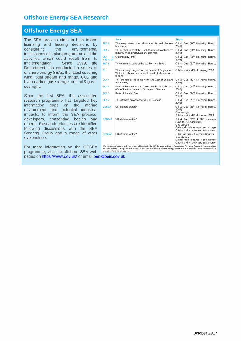
Offshore Energy SEA
The SEA process aims to help inform licensing and leasing decisions by considering the environmental implications of a plan/programme and the activities which could result from its implementation. Since 1999, the Department has conducted a series of offshore energy SEAs, the latest covering wind, tidal stream and range, CO2 and hydrocarbon gas storage, and oil & gas – see right. Since the first SEA, the associated research programme has targeted key information gaps on the marine environment and potential industrial impacts, to inform the SEA process, developers, consenting bodies and others. Research priorities are identified following discussions with the SEA Steering Group and a range of other stakeholders. For more information on the OESEA programme, visit the offshore SEA web pages on https://www.gov.uk/ or email [email protected]
Area Sector
SEA 1
The deep water area along the UK and Faroese boundary
Oil & Gas (19th Licensing Round, 2001)
SEA 2
The central spine of the North Sea which contains the majority of existing UK oil and gas fields
Oil & Gas (20th Licensing Round, 2002)
SEA 2 Extension
Outer Moray Firth Oil & Gas (20th Licensing Round, 2002)
SEA 3 The remaining parts of the southern North Sea Oil & Gas (21st Licensing Round, 2003)
R2 Three strategic regions off the coasts of England and Wales in relation to a second round of offshore wind leasing
Offshore wind (R2 of Leasing, 2003)
SEA 4
The offshore areas to the north and west of Shetland and Orkney
Oil & Gas (22nd Licensing Round, 2004)
SEA 5
Parts of the northern and central North Sea to the east of the Scottish mainland, Orkney and Shetland
Oil & Gas (23rd Licensing Round, 2005)
SEA 6 Parts of the Irish Sea Oil & Gas (24th Licensing Round, 2006)
SEA 7 The offshore areas to the west of Scotland Oil & Gas (25th Licensing Round, 2008)
OESEA UK offshore waters* Oil & Gas (26th Licensing Round, 2009) Gas storage Offshore wind (R3 of Leasing, 2009)
OESEA2 UK offshore waters* Oil & Gas (27th & 28th Licensing Rounds, 2012 and 2014) Gas storage Carbon dioxide transport and storage Offshore wind, wave and tidal energy
OESEA3 UK offshore waters* Oil & Gas (future Licensing Rounds) Gas storage Carbon dioxide transport and storage Offshore wind, wave and tidal energy
*For renewable energy included potential leasing in the UK Renewable Energy Zone (now Exclusive Economic Zone) and the territorial waters of England and Wales but not the Scottish Renewable Energy Zone and Northern Irish waters within the 12 nautical mile territorial sea limit