Embed Size (px)
Citation preview
r I
'1 z I
1
i
Int. J. Salt Lake Res. 2(1) (1993) 17-28
Recent limnological changes in a saline lake of the Bolivian Altiplano, Lake Poopo
André Iltis
Museum National d'Histoire Naturelle, Laboratoire de Cryptogamie, 12 rue Buffon, 75005, Paris, France.
c
Key Words: evolution, morphometry, phytoplankton, saline lake, high plateaux, Bolivia, South America
Abstract
During the past twelve years, Lake Poopo, located on the Bolivian Altipiano, has had two main types of morphometry. Before 1985, its level was low and the depth shallow (maximum 3 m); there was no outlet and a strong salinity gradient existed from north to south. After 1985, the depth doubled, an outlet developed and the salinity became uniform throughout the lake (-10 g L-1). Before 1985, the phytoplankton was distinguished by a high number of diatom taxa and by the dominance of diatoms in the algal biomass. After 1985, while diatoms were still numerous in terms of species composition, Peridiniales or Chlorophyceae dominated the algal biomass.
Introduction
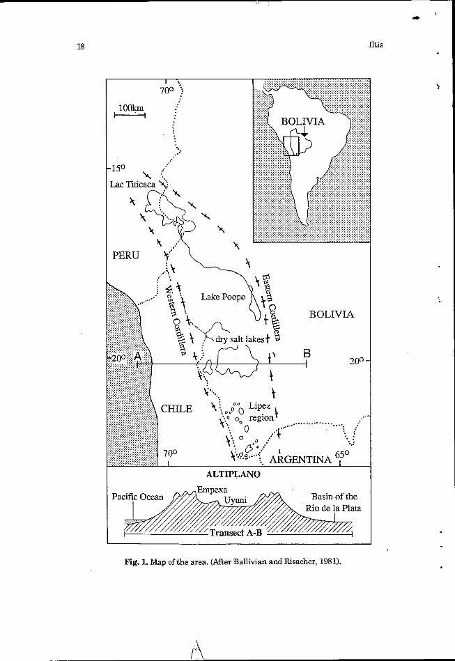
The drainage basin of Lake Poopo, with an area of -55,000 km2, is situated between 66'22' and 70'05' E and 16"16' and 20" S. It is part of the endorheic system of the Peruvian-Bolivian Altiplano, which, with an area of -190,000 km2, includes to the north the basin of Lake Titicaca, in the centre the basin of Lake Poopo, and in the south the zone óf salars (Coipasa, Uyuni, South-Lipez) (Fig. 1). A strong salinity gradient exists in this system from north to south: Lake Titicaca is a deep freshwater lake, Lake Poopo is a shallow saline lake, and the 'salars' comprise salt crusts covered only temporarily and partially by a thin layer of water which at maximum is only 20 cm deep (Ballivian and Risacher, 1981).
i The principal inflow of Lake Poopo is the Desaguadero. This arises from the southern part of Lake Titicaca and reaches Lake Poopo after
18
PERU Y'
..... . . : /.......... . .... . . . . . . . . -..:
ALTIPLANO
Basin of the ta
4vzzzZ//////////// Transect A-B - Fig. 1. Map of the area. (After Ballivian and Risacher, 1981).
r)
Iltis
Recent limnological changes in Lake Poopo 19 L
some 350 km. The average gradient of this river is very slight (0.03 per cent) since the altitude of Titicaca is 3,810 m and that of Poopo -3,690 m, that is, only about 120 m lower.
4
The level of Lake Titicaca can vary up t o 2 m between years, and so its outflow and thus the inflow into Lake Poopo is also variable (Carmouze et al., 1977 and 1978, Guyot et al., 1989). As a result, significant variations in the nature of the lake have occurred in the past as well as in more recent times. The first observations on Lake Poopo were made by exploring naturalists at the beginning of the century, They indicated the presence of a lake that was 88 km long and 40 km wide. More comprehensive limnological observations were not made until 1977. The present paper reports on important changes in the nature of the lake during the past fifteen years.
Recent changes in major limnological features
Two configurations of the lake can be distinguished from observations made during the past dozen years.
The first configuration relates to the situation prior to 1985. The Desaguadero then discharged near the town of Oruro into a wide zone of flooded pampa which formed an extensive area of shallow water, Lake Uru-Uru, where suspended matter settled. From there, waters reached the north of Lake Poopo by a narrow channel -20 km long. It is noteworthy that Lake Uru-Uru did not exist at the beginning of this Century.
The maximum depth of Lake Poopo in 1977 varied between 2.20 m at high water-levels t o 1.60 m at low water-levels. According t o i ts morphometry, two large zones could be distinguished: a central region of -1,500 km2 where the depth varied between 0.50 and 2.20 m, and a peripheral region which could reach 1,000 km2 in area but which had a depth <50 cm (Boulangé e t al., 1978). Observations made in 1979 indicated a maximal depth of 2.90 m with a total area of -2,700 km2 (Collot, 1982).
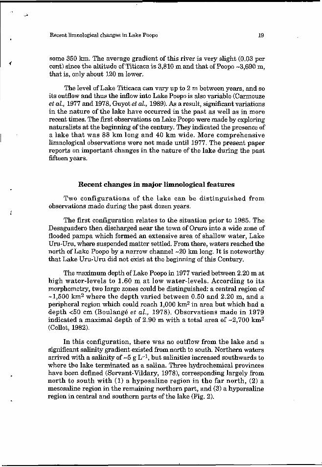
In this configuration, there was no outflow from the lake and a significant salinity gradient existed from north to south. Northern waters arrived with a salinity of -5 g L-1, but salinities increased southwards to where the lake terminated as a salina. Three hydrochemical provinces have been defined (Servant-Vildary, 19781, corresponding largely from north t o south with (1) a hyposaline region in the far north, (2) a mesosaline region in the remaining northern part, and (3) a hypersaline region in central and southern parts of the lake (Fig. 2).
20 Iltis
Fig. 2. Map of Lake Poopo. Dashed line, approximate contour of the lake before 1985 (three hydrochemical provinces); continuous line, approximate contour after 1985. (After Servant-Vildary, 1978). A and B: Location of samples made before 1982. Lines indicate approximate sample transects between March 1987 and April 1989.

Recent limnological changes in Lake Poopo 21 . An important flora of aquatic macrophytes W e n , 1940; Tutin, 1940)
occurred on the bottom sediments of part of the lake basin (68 per cent around the surface). The bottom of the central part, aligned north-south (32 per cent of the area), comprised compact grey sediment and lacked vegetation. Where macrophytes existed, Ruppia and Chara constituted most of them (Collot, 1982). This situation still existed at the end of 1982: a salinity of 7.5 g L-1 was observed at the level of Pazna in the north of the lake and of 75 g L-1 near Huari in the south (unpublished information).
.?
The second configuration relates to the situation after 1985. The exceptionally large increase in the level of Lake Titcaca in 1985 resulted in an increase in the flow of the Desaguadero and, then, a large increase in the level of Lake Poopo. The Desaguadero changed the course of its lower reaches and discharged not into Lake Uru-Uru but into the north- western part of Lake Poopo itself. The maximum depth in the centre of the lake reached 6 m and surface waters extended to the level of the lake shores. The area of the lake was then approximately 3,500 km2. A former river outlet, the Laca Jahuira, was reactivated. Leaving from the southern part of the lake, it flowed westwards, overflowing from the lake towards the salar of Coipasa some hundred kilometres away.
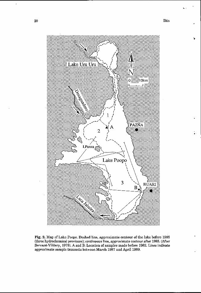
A uniform salinity developed throughout the lake: in all regions, it was between 8 and 11 g L-I (hyposaline). From observations between 1987 and 1989 (Table 11, the major features of the water-body were as follows. Surface temperatures (between 13.3 and 18.8"C on the basis of occasional measurements) were analogous to those observed in Lake Titicaca in the shallow southern part referred to locally as 'Huinaimarca' where they varied from about 8 to 18" according to season. Conductivity varied from 10,000 to 14,300 pS cm-1 (at 25°C). Given the relatively slight depth of certain lake regions, water transparency varied widely according to position, wind speed, the nature of the bottom and the rate of inflows following rain. The mean of nine observations at different positions in the lake was from 0.9 min March 1987,O.W min December of the same year, 1.67 m in March 1988,1.19 m in December 1988, and 1.8 min April 1989. The most turbid regions were $ways in the north-west of the lake where the Desaguadero then discharged, with a transparency regularly <1 m.
i / '
Values of pH ranged from 8.17 to 9.05. The major ions comprising the dissolved salts were Cl-, SO4% and Na+. As before, an important aquatic flora developed on the lake bed, principally in all the zones of recent inundation. Nevertheless, there was always an elongated central zone where macrophytes were absent. There are no precise estimates of the area occupied by different genera at each stage of the lake water; it appears, even so, that Ruppia is in regression in different border zones compared with the previous situation when the lake lacked outlet. The
22 Iltis I
Characeae seem largely dominant except in the north-west at the new inlet of the River Desaguadero where Ruppia still covers large areas.
U
Recent limnological changes in Lake Poop0 I
23
Changes in the phytoplankton t
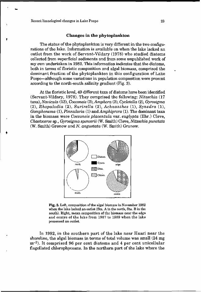
The status of the phytoplankton is very different in the two configu- rations of the lake. Information is available on when the lake lacked an outlet from the work of Servant-Vildary (1978) who studied diatoms collected from superficial sediments and from some unpublished work of my own undertaken in 1982. This information indicates that the diatoms, both in terms of floristic composition and algal biomass, comprised the dominant fraction of the phytoplankton in this configuration of Lake Poopo-although some variations in population composition were present according to the north-south salinity gradient (Fig. 3).
.
At the floristic level, 49 different taxa of diatoms have been identified (Servant-Vildary, 1978). They comprised the following: Nitzschia (17 taxa), Navicula (13), Cocconeis (31, Amphora (3), Cyclotella (21, Gyrosigma (2), Rhopalodia (2), Surirella (2), Achnanthes (l), Synedra (l), Gomphomma (11, Pinnularia (1) and Amphiprora (1). The dominant taxa in the biomass were Cocconeis placentula var. euglypta (Ehr.) Cleve, Chaetoceros sp., Gyrosigma spencerii (W. Smith) Cleve, Nitzschia punctata (W. Smith) Grunow and N. angustata (W. Smith) Grunow.
4
Centre south
Fig. 3. Left, composition of the algal biomass in November 1982 when the lake lacked an outlet (Sta. A in the north, Sta. B in the south). Right, mean composition of the biomass near the edge and centre of the lake from 1987 t o 1989 when the lake possessed an outlet.
In 1982, in the southern part of the lake near Huari near the shoreline, the algal biomass in terms of total volume was small (24 mg m-3). It comprised 96 per cent diatoms and 4 per cent unicellular flagellated chlorophyceans. In the northern part of the lake where the
24 Iltis
salinity was about ten times lower (7.5 g L-I), the algal biomass was much higher (21.5 g m-3). It comprised 64 per cent diatoms, 34 per cent pyrrophytes and 2 per cent cyanophytes.
Information on the situation when the lake had an outlet was obtained between 1987 and 1989 during five expeditions to different parts of the lake basin (Fig. 3). The floristic composition at this time was 3 taxa of cyanophytes, 13 chlorophyceans, 3 dinophyceans and 1 euglenophycean. Diatoms, identified only to generic level, were represented by 8 genera.
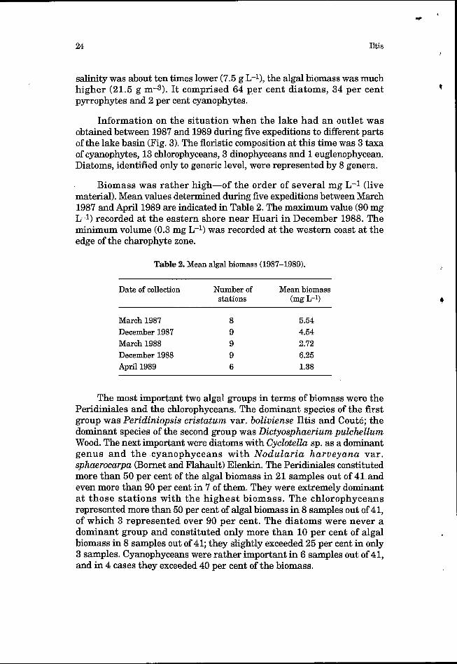
Biomass was rather high-of the order of several mg L-1 (live material). Mean values determined during five expeditions between March 1987 and April 1989 are indicated in Table 2. The maximum value (90 mg L-1) recorded at the eastern shore near Huari in December 1988. The minimum volume (0.3 mg L-I) was recorded at the western coast at the edge of the charophyte zone.
Table 2. Mean algal biomass (1987-1989).
Date of collection Number of Mean biomass stations (mg L-9
March 1987 8 5.54 December 1987 9 4.54 March 1988 9 2.72 December 1988 9 6.25 April 1989 6 1.38
The most important two algal groups in terms of biomass were the Peridiniales and the chlorophyceans. The dominant species of the first group was Peridiniopsis cristatum var. boliviense Iltis and Couté; the dominant species of the second group was Dictyosphaerium pulchellum Wood. The next important were diatoms with Cyclotella sp. as a dominant genus and the cyanophyceans with Nodularia harveyana var. sphaerocarpa (Bornet and Flahault) Elenkin. The Peridiniales constituted more than 50 per cent of the algal biomass in 21 samples out of 41 and even more than 90 per cent in 7 of them. They were extremely dominant at those stations with the highest biomass. The chlorophyceans represented more than 50 per cent of algal biomass in 8 samples out of 41, of which 3 represented over 90 per cent. The diatoms were never a dominant group and constituted only more than 10 per cent of algal biomass in 8 samples out of 41; they slightly exceeded 25 per cent in only 3 samples. Cyanophyceans were rather important in 6 samples out of 41, and in 4 cases they exceeded 40 per cent of the biomass.
Recent limnological changes in Lake Poopo 25 <
With regard to the spatio-temporal distribution of the biomass, because of the timing of sample collections it is not possible to discern seasonal variations. No differences have been observed between samples collected at the end of the dry season (December ) and those collected at the end of the wet season (March-April); presumably, those differences encountered were not related t o a seasonal cycle. More frequent observations would be needed for adequate resolution of this question.
t
With regard to spatial variation, the following points may be made. The greatest biomass occurred near the lake’s shores, with Peridiniopsis cristatum var. boliviense dominant. The central zone, with a smaller biomass, was characterised by an abundance of Dictyosphaerium pulchellum. The central zone had a low transparency throughout. Presumably, suspended matter was the principal cause of the water’s turbidity. Elsewhere, turbidity was highest near the inlet of the Desaguadero. It was high too in the central region lacking macrophytes where, during strong winds, disturbed sediments remained in suspension.
Discussion
Because salt lakes are most often found in hydrologically endoreic or areic systems, these athalassic waters are frequently subject to signif3cant interannual variations in physicochemical features, especially salinity. Biological changes which follow are often of considerable amplitude. However, changes of this sort over extended periods have been seldom studied. An exception is provided by studies of the Great Salt Lake in Utah, USA (Jensen and Arnow, 1972; Greer, 1977; Amow, 1978; and Stephens, 1990). These studies cover environmental changes from 1847 until 1987.
In the case of Lake Poopo and its evolution over the last 12 years, apart from the observations on the phytoplankton reported in this paper, there exist only isolated observations on variations in other biological components. A few analyses of the benthic fauna made between 1987 and 1989 (Iltis et al., 1990) suggest that this fauna adapted only slowly to the new environmental conditions after 1985. In 1989, colonisation of new aquatic regions had begun. Changes to the composition of the macrophyte flora also appeared after 1985. Taking the situation described by Collot (1982) as a reference point, the areas of Ruppia showed a net regression after 1985, although the change was relatively slow. For fish populations, observations are almost non-existent: according to some local fishermen, the ‘pejerrey’ (Basilichthys bonariensis), an introduced species, and several species of the endemic genus Orestìas are available in local fish catches. Fish used to occur only in the northern part of the lake as the
26
* *
Iltis
southern part was too saline before 1985. After 1985, when salinity was
parts. In this regard, the evolution of populations as a response to salinity variations remains little known and unpredictable: information on the response of organisms to changes in salinity in athalassic waters of South America does not exist, unlike, for example, the situation with regard t o aquatic species in Australia (Hart et al., 1991). Even so, observations on these components of the biota show that variation displayed by them follows salinity variation after an important delay.
uniformly low throughout the basin, fishing was equally good in both t
Finally, in the present state of our knowledge of Lake Poopo, the phytoplankton appears to respond most rapidly to changed physico-chemical conditions and is therefore the best biological indicator of these conditions, especially salinity, in the lake at any given time. According to observations made on African carbonate lakes, an inverse relationship exists between the number of algal species and salinity (Iltis, 1973a). Elsewhere, a general relationship between the number of species and salinity is indicated by Hammer (1986) and, in modified form, by Williams et al, (1990) for Australian lakes. A positive correlation has been observed between algal biomass and salinity in the salt lakes of Chad and variations in the proportions of different
concentration of dissolved salts (Iltis, 197313).
1
algal groups in the biomass have been related t o fluctuations in the 1
It is evident that each geographical athalassic assemblage has its own characteristics, and so conclusions obtained from studies of one of them cannot be applied directly to a group of saline lakes in another region. Further studies to complement those on Lake Poopo are necessary and these should particularly address conditions in the period between the two configurations of the lake. I t should then be possible to provide a predictive model on the qualitative and quantitative composition of the plankton in relation to the concentration of dissolved salts and lake level. Such a model would complement that on the energy flux outlined by Hurlbert et al. (1986) for the Altiplano lakes of South America. However, access to study Lake Poopo is relatively difficult and one can anticipate that good limnological knowledge will not be acquired for several years.
Acknowledgements
This work has been undertaken with the help of a convention between the Universidad Mayor de San Andrés at La Paz and the Institut Fransais de RechercheScientifique pour le Développement en Coopération in Paris. Professor W.D. Williams is thanked very much for his k h d translation of the original manuscript.
i
Recent limnological changes in Lake Poopo 27
i
References
Allen, G.O., 1940. M. Charophyta. In: Reports of the Percy Sladen Trust Expedition to Lake Titicaca in 1937. Transactions of the Linnean Society ofLondon, ser. 3, l(2): 155-160.
h o w , T., 1978. Water budget and water-surface fluctuations, Great Salt Lake, Utah, US Dept. Interior, Geol. Survey, Open-File Dept. 78- 912. Salt Lake City, Utah, 21 p.
Ballivian, O., and Risacher, F., 1981. Los Salares del Altiplano Boliviano. ORSTOM, Paris, 246 p., multigr.
Boulange, B., Rodrigo, L.A., and Vargas, C., 1978. Morphologie, formation et aspects sédimentologiques du lac Poopo (Bolivie). Cahiers ORSTOM, sbrie Gbologie lO(1): 69-78.
Carmouze, J.P., Arce, C., and Quintanilla, J., 1977. La régulation hydrique des lacs Titicaca et Poopo. Cahiers ORSTOM, sbrie Hydrobiologie ll(4): 269-283.
Carmouze, J.P., Arce C., and QLntanilla, J., 1978. Circulacion de materia (aguas, sales disueltas) en el sistema del Altiplano: la regulacion hidroquimica de los lagos Titicaca y Poopo. Cahiers ORSTOM, sbrie Gbologie lO(1): 49-68.
Collot, J.L., 1982. Vegetacion acuatica del Lago 1Poopo. Revista del Instituto de Ecologia de La Paz 1: 47-55.
Greer, D.C., Ed., 1977. Desertic Terminal Lakes. Utah Water Res. Lab., Utah State Univ., Logan, Utah.
Guyot, J.L., Roche, M.A., Quintanilla, J., Calliconde, N., Noriega, L., Calle, H., and Cortes, J., 1989. Cargas en suspension y transportes de materia sobre el Altiplano boliviano. Doc. PHICAB-ORSTOM, 20 p., multigr.
Hammer, U.T., 1986. Saline Lake Ecosystems of the World.
Hart, B.T., Bailey, P., Edwards, R., Hortle, K., James, K., McMahon, A., Meredith, C., and Swadling, K., 1991. A review of the salt sensitivity of the Australian freshwater biota. Hydrobiologia 210: 105-144.
Hurlbert, S.H., Loayza, W., and Moreno, T., 1986. Fish flamingo plankton interactions in the Peruvian Andes. Limnology and Oceanography 31(3): 457468.
Iltis, A., 1973a. Algues des eaux natronées du Kanem (Tchad) (2éme Partie). Cahiers ORSTOM, skrie Hydrobiologie 7( 1): 25-54.
Iltis, A., 1973b. Phytoplancton des eaux natronées du h e m (Tchad). VI. Estimation des biomasses et groupes d'algues dominants. Cahiers ORSTOM, sbrie Hydrobiologie 7(34): 167-194:.
Iltis, A., and Couté, A., 1984. Péridiniales (Algae, Pyrrhophyta) de Bolivie. Revue d'Hydrobiologie Tropicale 17(4): 279-286.
Monographiae biologicae 59, Junk, Dordrecht. t
28 Iltis
Iltis, A., Dejoux, C., and Wasson, J.G., 1990. Datos hidrobiologicos referentes al Lag Poopo (Bolivia). Doc. UMSA-ORSTOM 21: 19p., multigr.
Jensen, L.J.j and h o w , T., 1972. Fluctuations of the surface elevation of Great Salt Lake, Utah. In: J.P. Riley (Ed.) The Great Salt Lake and Utah's Water Resources. pp. 41-48. Proc. First Ann. Conf. Utah Sec., Am. Water Res. ASSOC., Utah Water Res. Lab., Utah State
Neveu-Lemaire, M., 1906. El Titicaca y el Poopo. Contribucion al estudio de los lagos de los altiplanos bolivianos. Revista del Ministerio de Colonias y Agricultura, ano 11( 16-17-18): 568-591.
Neveu-Lemaire, M., 1906. Les Lacs des Hauts Plateaux de l'Amérique de Sud. Imprimerie Nationale, Paris.
Servant-Vildary, S., 1978. Les Diatomées des sédiments superficiels d'un lac salé sulfaté sodique de YAltiplano bolivien, le lac Poopo. Cahiers ORSTOM, skrie Gkologie 10( 1): 79-87.
Stephens, D.W., 1990. Changes in lake levels, salinity and the biological community of Great Salt Lake (Utah, USA), 1847-1987. Hydrobiologia 197: 139-146.
Tutin, M.A., 1940. X. The macrophytic vegetation. In: Reports of the Percy Sladen Trust Expedition to Lake Titicaca in 1937. Transactions of the Linnean Society of London, series 3, l(2): 161-190.
Williams, W.D., Boulton, A.J., and Taaffe, R.G., 1990. Salinity as a determinant of salt lake fauna: A question of scale. Hydrobiologia
univ., Logan, Utah.
197: 257-266.