Embed Size (px)
Citation preview
GPS Occultation Studies of the Lower GPS Occultation Studies of the Lower Ionosphere: Current Investigations and Ionosphere: Current Investigations and Future Roles for C/NOFS & COSMIC Future Roles for C/NOFS & COSMIC
SensorsSensors
R. BishopR. Bishop11, P. Straus, P. Straus11, P. Anderson, P. Anderson22, M. Nicolls, M. Nicolls33, V. Wong, V. Wong33, M. , M. KelleyKelley33, T. Bullett, T. Bullett44
1The Aerospace Corporation, 2University of Texas @ Dallas, 3Cornell University, 4AFRL
Copyright of The Aerospace Corporation, 2005
OutlineOutlineOngoing GPS RO Ionospheric Ongoing GPS RO Ionospheric
InvestigationsInvestigations ScintillationScintillation
Global equatorial Global equatorial distributiondistribution
Tropospheric/Ionospheric Tropospheric/Ionospheric couplingcoupling
Mid-latitude scintillation Mid-latitude scintillation occurrenceoccurrence
E-region StudiesE-region Studies Single profile extraction Single profile extraction
techniquestechniques Validation with ISRValidation with ISR E-F region couplingE-F region coupling
Future Roles for C/NOFS & Future Roles for C/NOFS & COSMIC GPS receiversCOSMIC GPS receivers
Brief CORISS Brief CORISS (C/NOFS) instrument (C/NOFS) instrument overviewoverview
Goals of C/NOFS Goals of C/NOFS studystudy
Possible future Possible future equatorial Studiesequatorial Studies
Collaboration with Collaboration with COSMIC satellites COSMIC satellites Study examplesStudy examples

Satellite GPS Occultation Satellite GPS Occultation Ionospheric Data SourcesIonospheric Data Sources
CHAMPCHAMP ~400 km~400 km 88° inclination 88° inclination
SAC-CSAC-C ~700 km~700 km 98° inclination – sun synchronous98° inclination – sun synchronous
PICO Sat/IOXPICO Sat/IOX ~800 km~800 km 75° inclination75° inclination
IOX is the only instrument with ionospheric IOX is the only instrument with ionospheric mission focusmission focus Provides majority of assimilated ionospheric Provides majority of assimilated ionospheric
occultation dataoccultation data Up to 500 occultations a dayUp to 500 occultations a day
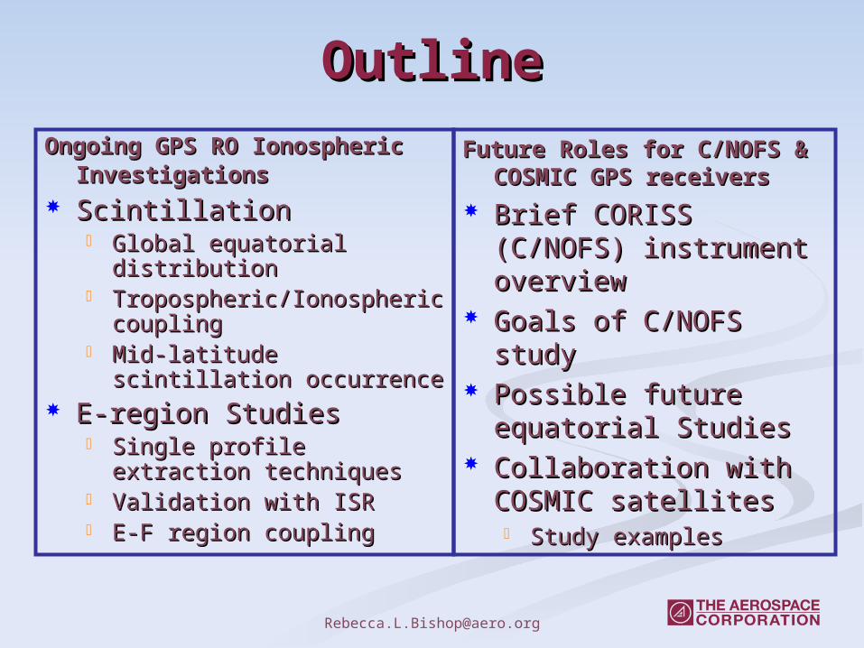
2002 Scintillation 2002 Scintillation OccurrenceOccurrence
PICOSat/IOX orbit precesses PICOSat/IOX orbit precesses 360º in ~100 days - full local 360º in ~100 days - full local time coverage in ~50 daystime coverage in ~50 days
CHAMP orbit precesses 360º CHAMP orbit precesses 360º in ~260 days - full local time in ~260 days - full local time coverage in ~130 dayscoverage in ~130 days
Analysis limited to ray path Analysis limited to ray path tangent point altitudes above tangent point altitudes above 200km.200km.
Rate of descent of the ray path Rate of descent of the ray path tangent point:tangent point: IOX and SAC-C - from ~300 m/sec IOX and SAC-C - from ~300 m/sec
to ~2.5 km/sec to ~2.5 km/sec CHAMP - from ~150 m/sec to ~2 CHAMP - from ~150 m/sec to ~2
km/seckm/sec Equivalent to minimum scale Equivalent to minimum scale
sizes of the irregularities sizes of the irregularities sampled by the GPS sampled by the GPS occultation receivers for 1-sec occultation receivers for 1-sec observationsobservations
Local Time Distribution
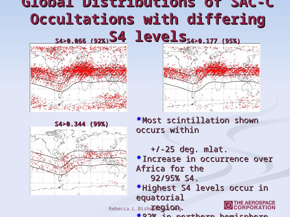
Global Distributions of SAC-C Global Distributions of SAC-C Occultations with differing S4 Occultations with differing S4
levelslevelsS4>0.066 (92%)S4>0.066 (92%) S4>0.177 (95%)S4>0.177 (95%)
S4>0.344 (99%)S4>0.344 (99%)Most scintillation shown occurs within Most scintillation shown occurs within +/-25 deg. mlat.+/-25 deg. mlat.Increase in occurrence over Africa for the Increase in occurrence over Africa for the 92/95% S4.92/95% S4.Highest S4 levels occur in equatorial Highest S4 levels occur in equatorial region.region.82% in northern hemisphere82% in northern hemisphere
Driven by magnetic field configuration Driven by magnetic field configuration and occultation geometry.and occultation geometry.
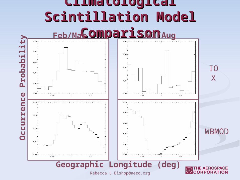
Climatological Scintillation Climatological Scintillation Model ComparisonModel Comparison
Geographic Longitude (deg)
Occ
urr
ence
Pro
bab
ilit
y
WBMOD
Feb/Mar Jul/Aug
IOX
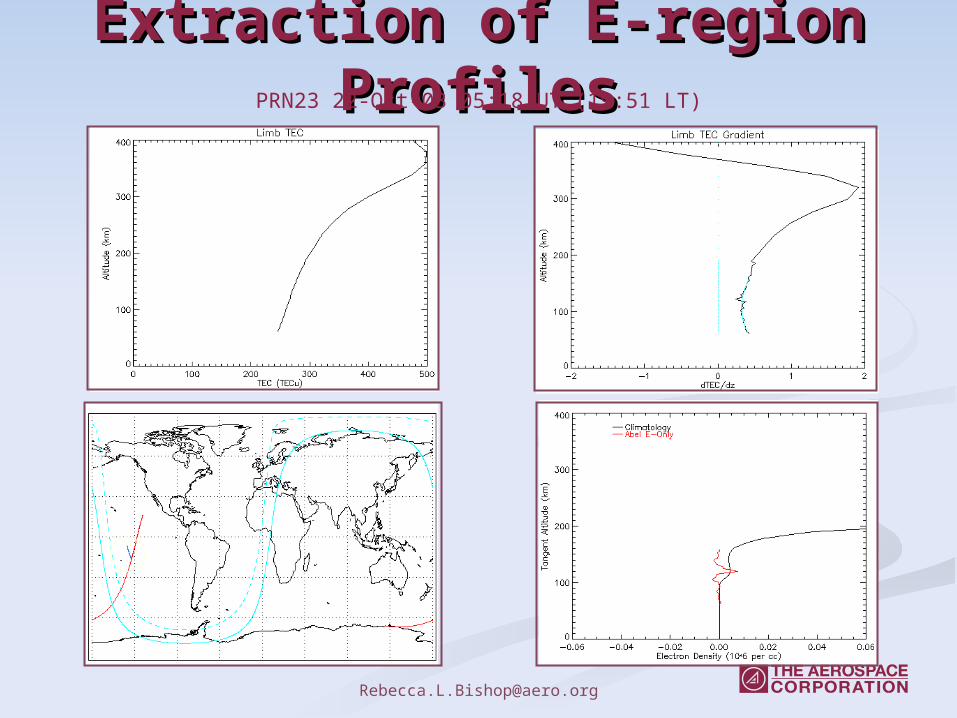
Extraction of E-region Extraction of E-region ProfilesProfilesPRN23 22-Oct-03 05:18 UT (19:51 LT)
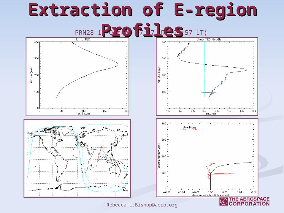
Extraction of E-region Extraction of E-region ProfilesProfilesPRN28 15-Oct-03 17:17 UT (23:57 LT)
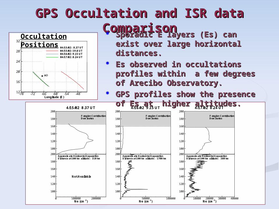
GPS Occultation and ISR data GPS Occultation and ISR data ComparisonComparison
Longitude (E)
Latitude(N)
-78 -72 -66 -60 -54 -4812
16
20
24
28
32
04/15/02: 8.37 UT04/15/02: 19.8 UT04/16/02: 9.15 UT04/17/02: 8.24 UT
°
°
°
°
°
°
°° ° ° °
AO
°
Occultation Positions
Altitude(km)
100
120
140
160
180
2004/17/02 8.24 UT
F-region ContributionDominates
Ne (cm-3)
Altitude(km)
0 10000 20000 30000 40000
100
120
140
160
180
200Approximate Horizontal SeparationDistance at 100 km altitude: 380 km
Altitude(km)
100
120
140
160
180
2004/16/02 9.15 UT
F-region ContributionDominates
Ne (cm-3)
Altitude(km)
0 50000 100000
100
120
140
160
180
200Approximate Horizontal SeparationDistance at 100 km altitude: 1700 km
Altitude(km)
100
120
140
160
180
2004/15/02 8.37 UT
F-region ContributionDominates
Ne (cm-3)
Altitude(km)
0 100000 200000
100
120
140
160
180
200Approximate Horizontal SeparationDistance at 100 km altitude: 310 km
Not Available
Sporadic E layers (Es) can exist Sporadic E layers (Es) can exist over large horizontal distances.over large horizontal distances.
Es observed in occultations Es observed in occultations profiles within a few degrees of profiles within a few degrees of Arecibo Observatory.Arecibo Observatory.
GPS profiles show the presence GPS profiles show the presence of Es at higher altitudes.of Es at higher altitudes.
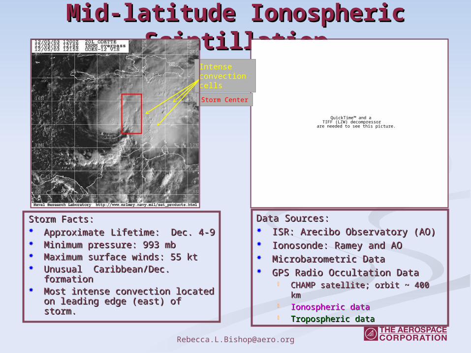
Mid-latitude Ionospheric Mid-latitude Ionospheric ScintillationScintillation
QuickTime™ and aTIFF (LZW) decompressor
are needed to see this picture.
Intense convection cells
Storm Center
Data Sources:Data Sources: ISR: Arecibo Observatory (AO)ISR: Arecibo Observatory (AO) Ionosonde: Ramey and AOIonosonde: Ramey and AO Microbarometric DataMicrobarometric Data GPS Radio Occultation DataGPS Radio Occultation Data
CHAMP satellite; orbit ~ 400 kmCHAMP satellite; orbit ~ 400 km Ionospheric dataIonospheric data Tropospheric dataTropospheric data
Storm Facts:Storm Facts: ApproximateApproximate Lifetime: Dec. 4-9Lifetime: Dec. 4-9 Minimum pressure: 993 mbMinimum pressure: 993 mb Maximum surface winds: 55 ktMaximum surface winds: 55 kt Unusual Caribbean/Dec. formationUnusual Caribbean/Dec. formation Most intense convection located on Most intense convection located on
leading edge (east) of storm. leading edge (east) of storm.
Surface & Geomagnetic Surface & Geomagnetic ConditionsConditions
Dst
Dst
-50
0
50 Spreading Occurrence
December 2003
nT
2 4 6 8 10-20
0
20Bz
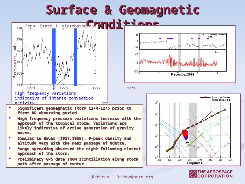
High frequency variations indicative of intense convection activity.
Pre
ssu
re, m
b
978
976
974
972
970
12/3 12/5 12/7 12/9968
Penn. State U. microbarograph
Significant geomagnetic storm 12/4-12/5 prior to first AO Significant geomagnetic storm 12/4-12/5 prior to first AO observing period.observing period.
High frequency pressure variations increase with the approach High frequency pressure variations increase with the approach of the tropical storm. Variations are likely indicative of active of the tropical storm. Variations are likely indicative of active generation of gravity waves.generation of gravity waves.
Similar to Bauer [1957,1958], F-peak density and altitude vary Similar to Bauer [1957,1958], F-peak density and altitude vary with the near passage of Odette.with the near passage of Odette.
Range spreading observed the night following closest Range spreading observed the night following closest approach of the storm.approach of the storm.
Preliminary GPS data show scintillation along storm path after Preliminary GPS data show scintillation along storm path after passage of center.passage of center. Longitude E
LatitudeN
280 285 290 295 300 305 310 31510
15
20
25
30
35
Storm Eye/CenterApproximate width
AO
°
°°°°°°
°°°°
°
°
°
° ° ° ° °
AO
°
°°°°°°
°°°°
°
°
°
° ° ° ° °
°
°°°°°°
°°°°
°
°
°
° ° ° ° °
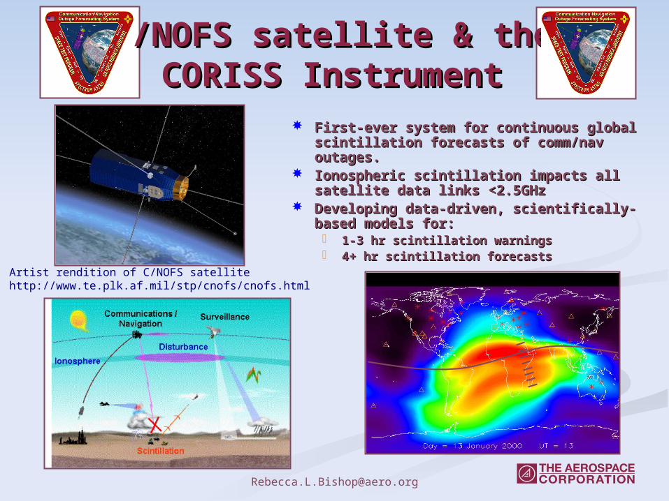
C/NOFS satellite & the C/NOFS satellite & the CORISS InstrumentCORISS Instrument
First-ever system for continuous global First-ever system for continuous global scintillation forecasts of comm/nav outages.scintillation forecasts of comm/nav outages.
Ionospheric scintillation impacts all satellite Ionospheric scintillation impacts all satellite data links <2.5GHzdata links <2.5GHz
Developing data-driven, scientifically-based Developing data-driven, scientifically-based models for:models for: 1-3 hr scintillation warnings1-3 hr scintillation warnings 4+ hr scintillation forecasts4+ hr scintillation forecasts
Artist rendition of C/NOFS satellitehttp://www.te.plk.af.mil/stp/cnofs/cnofs.html
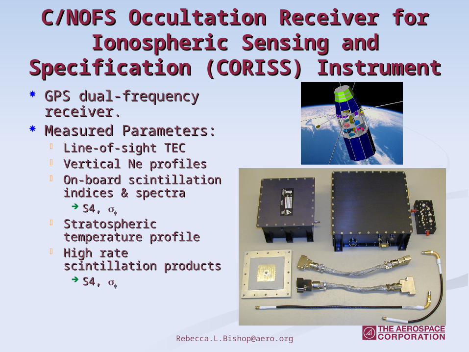
C/NOFS Occultation Receiver for C/NOFS Occultation Receiver for Ionospheric Sensing and Specification Ionospheric Sensing and Specification
(CORISS)(CORISS) Instrument Instrument GPS dual-frequency GPS dual-frequency
receiver.receiver. Measured Measured
Parameters:Parameters: Line-of-sight TECLine-of-sight TEC Vertical Ne profilesVertical Ne profiles On-board scintillation On-board scintillation
indices & spectraindices & spectra S4, S4,
Stratospheric Stratospheric temperature profiletemperature profile
High rate scintillation High rate scintillation productsproducts
S4, S4,
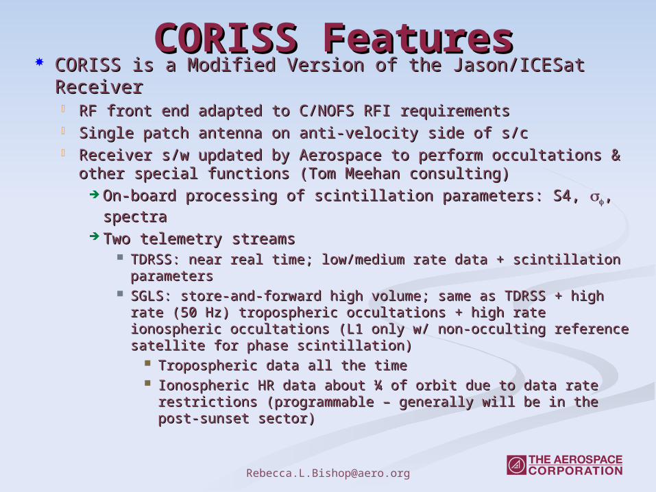
CORISS FeaturesCORISS Features CORISS is a Modified Version of the Jason/ICESat CORISS is a Modified Version of the Jason/ICESat
ReceiverReceiver RF front end adapted to C/NOFS RFI requirementsRF front end adapted to C/NOFS RFI requirements Single patch antenna on anti-velocity side of s/cSingle patch antenna on anti-velocity side of s/c Receiver s/w updated by Aerospace to perform occultations & Receiver s/w updated by Aerospace to perform occultations &
other special functions (Tom Meehan consulting)other special functions (Tom Meehan consulting) On-board processing of scintillation parameters: S4, On-board processing of scintillation parameters: S4, , spectra, spectra Two telemetry streamsTwo telemetry streams
TDRSS: near real time; low/medium rate data + scintillation TDRSS: near real time; low/medium rate data + scintillation parametersparameters
SGLS: store-and-forward high volume; same as TDRSS + high rate SGLS: store-and-forward high volume; same as TDRSS + high rate (50 Hz) tropospheric occultations + high rate ionospheric (50 Hz) tropospheric occultations + high rate ionospheric occultations (L1 only w/ non-occulting reference satellite for phase occultations (L1 only w/ non-occulting reference satellite for phase scintillation)scintillation)
Tropospheric data all the timeTropospheric data all the time Ionospheric HR data about ¼ of orbit due to data rate Ionospheric HR data about ¼ of orbit due to data rate
restrictions (programmable – generally will be in the post-restrictions (programmable – generally will be in the post-sunset sector)sunset sector)
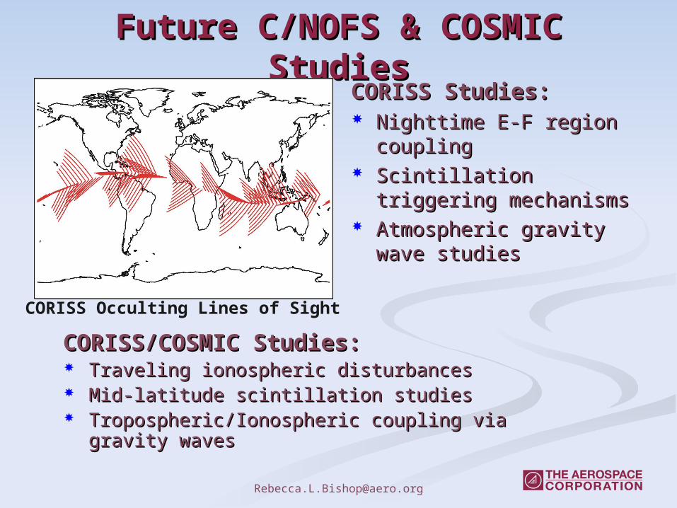
Future C/NOFS & COSMIC Future C/NOFS & COSMIC StudiesStudies
CORISS Studies:CORISS Studies: Nighttime E-F region Nighttime E-F region
couplingcoupling Scintillation triggering Scintillation triggering
mechanismsmechanisms Atmospheric gravity Atmospheric gravity
wave studieswave studies
CORISS Occulting Lines of Sight
CORISS/COSMIC Studies:CORISS/COSMIC Studies: Traveling ionospheric disturbancesTraveling ionospheric disturbances Mid-latitude scintillation studiesMid-latitude scintillation studies Tropospheric/Ionospheric coupling via gravity Tropospheric/Ionospheric coupling via gravity
waveswaves
Summary Summary GPS occultation data is highly useful for GPS occultation data is highly useful for
ionospheric studies. ionospheric studies. Provides global observations of the state of the Provides global observations of the state of the
ionosphereionosphere On-going investigations include:On-going investigations include:
Scintillation studies (IOX, C/NOFS)Scintillation studies (IOX, C/NOFS) Lower E-region validation studiesLower E-region validation studies Tropospheric/Ionospheric coupling via tropical stormsTropospheric/Ionospheric coupling via tropical storms
Future ionospheric studies would greatly Future ionospheric studies would greatly benefit from C/NOFS and COSMIC data and benefit from C/NOFS and COSMIC data and collaborative efforts.collaborative efforts. Ionospheric specification related to scintillation.Ionospheric specification related to scintillation. TEC response to geomagnetic changes.TEC response to geomagnetic changes.
Acknowledgements: The GPS data comes from the SAC-C and CHAMP/JPL website. This work was supported under The Aerospace Corporation's Independent Research and Development Program.The Arecibo Observatory is the principal facility of the National Astronomy and Ionosphere Center, which is operated by the Cornell University under a cooperative agreement with the National Science Foundation.