Embed Size (px)
Citation preview

Anil Kumar
Director, Environment Information Management
26 April 2012
Geospatial World Forum, Amsterdam, The Netherlands
Realizing benefits of Spatial Data Infrastructure A user’s perspective from Environment Agency - Abu Dhabi

PAGE 2 ENVIRONMENT AGENCY – ABU DHABI
Agenda Where is Abu Dhabi?
Introduction to Environment Agency – Abu Dhabi (EAD)
What does EAD do?
Geospatial initiatives – a quick glimpse
Evolution of AD – SDI
AD – SDI Benefits/Advantages
What Should SDI do?
Conclusion


PAGE 4 ENVIRONMENT AGENCY – ABU DHABI
Introduction • Governmental agency
• Established in 1996 (Law No. 4) as ERWDA
• Designated Competent Authority in 2000
– Charged with implementing Environmental laws
• Overall function of
– Protection, Conservation & Management
– Promote sustainable development
– Assist the AD Govt in implementing environmental
laws, policies and regulations

PAGE 5 ENVIRONMENT AGENCY – ABU DHABI
Preserve our
Natural Heritage
Protecting our
future
Educate and raise awareness
Our key roles:
• Preserve our Natural Heritage
• Protect our future
• Educate & raise awareness
Our priorities:
• To develop and implement an effective environmental
regulatory & policy framework for Abu Dhabi
• To conserve groundwater through integrated water
resources management
• To conserve and protect biodiversity
• To ensure our air is clean and minimize climate change & its
impacts
• To promote sustainable communities and engaged
stakeholders
• To continually improve the way we work
What do we do?

PAGE 6 ENVIRONMENT AGENCY – ABU DHABI
Geospatial Initiatives Protected Area Delineation
Coastal Sensitivity & Vulnerability
Groundwater Studies
Soils Survey
Wildlife Conservation

PAGE 7 ENVIRONMENT AGENCY – ABU DHABI
Geospatial Initiatives
Environmental Baseline Database Imagery Database
Air Quality Monitoring Climate Change Studies
Geospatial Analysis
Mobile Solutions

PAGE 8 ENVIRONMENT AGENCY – ABU DHABI
EAD Geospatial Portal

PAGE 9 ENVIRONMENT AGENCY – ABU DHABI
• Rapid growth and development
• Socio economic changes
• Increase in awareness of local & global
environmental issues
• National, Regional, International obligations
• Environment 2030, State of Environment
reporting, EPI, Ecological Footprint, etc…
• Information requests from leadership,
stakeholders, etc.
Need for Information
……requires comprehensive, accurate, timely and relevant
data & information…….

PAGE 10 ENVIRONMENT AGENCY – ABU DHABI
AD-SDI Evolution • EAD assigned “Competent Authority” Status in 2000
• Comprehensive review of data & information
requirements
• Major data elements held by other organizations
• Conceived Abu Dhabi Environmental Database (AD –
EDB)
• AD – EDB leading towards SDI
• ADSIC launched AD – SDI together with EAD & seven
other entities in 2007

PAGE 11 ENVIRONMENT AGENCY – ABU DHABI
GIS
Spatial
Data +
Base Map
Data
ba
se
Ap
plic
atio
n
GIS
Spatial
Data +
Base Map
Data
ba
se
Ap
plic
atio
n GIS
Spatial
Data +
Base Map
Data
ba
se
Ap
plic
atio
n
GIS
Spatial Data
+
Base Map
Data
ba
se
Ap
plic
atio
n GIS
Spatial Data
+
Base Map
Data
ba
se
Ap
plic
atio
n
Entity’s Geospatial Data & Applications
Utilities
Municipal
Natural Resources
Economy
Urban Planning
Infrastructure
Safety & Security
Others
AD-SDI Central Node Geospatial Data & Applications
Internet
GIS
Spati
al
Data
Data
ba
se
A
pp
lica
tion
GIS
Spati
al
Data
Data
ba
se
A
pp
lica
tion
GIS
Spati
al
Data
Data
ba
se
A
pp
lica
tion
GIS
Spatial
Data
Data
ba
se
A
pp
lica
tion
GeoPortal
SD Thematic
Layers + Data
Common
Base Map
Data
ba
ses
A
pp
licatio
n
Metadata
Catalog
Private
Sector
Academia
General
Public
Before 2007 Current Status
Utilities
Municipal
Natural Resources
Economy
Urban Planning
Infrastructure
Safety & Security
Others
SDC
AD-SDI Evolution

PAGE 12 ENVIRONMENT AGENCY – ABU DHABI
Operations
Planning & Analysis Decision Support
AD-SDI program supports inter-government and multi-stakeholder collaboration for better planning, analysis and decision making…
Information Sources
Inter-Government Collaboration
Multi-Stakeholder Collaboration

PAGE 13 ENVIRONMENT AGENCY – ABU DHABI
Enterprise
Info
Solutions
Enterprise
Info
Solutions
Enterprise
Info
Solutions
Enterprise
Info
Solutions
Enterprise
Info
Solutions
Enterprise
Info
Solutions
Enterprise
Info
Solutions
Decision
Making
Analysis
Advisory
Operations Strategic
Plan
Strategic
Plan
Strategic
Plan
Strategic
Plan
Strategic
Plan
Strategic
Plan
Strategic
Plan
KPI’s KPI’s KPI’s KPI’s KPI’s KPI’s KPI’s
Entity 1 Entity 2 Entity 3 Entity 4 Entity 5 Entity 6 Entity 7
Interdepartmental analysis and coordination
Interdisciplinary Technical Analysis, Planning, Coordination and Performance
Management
Whole Government
Economic
Social Environment &
Infrastructure
Executive
Council
Strategy and Policy Unit
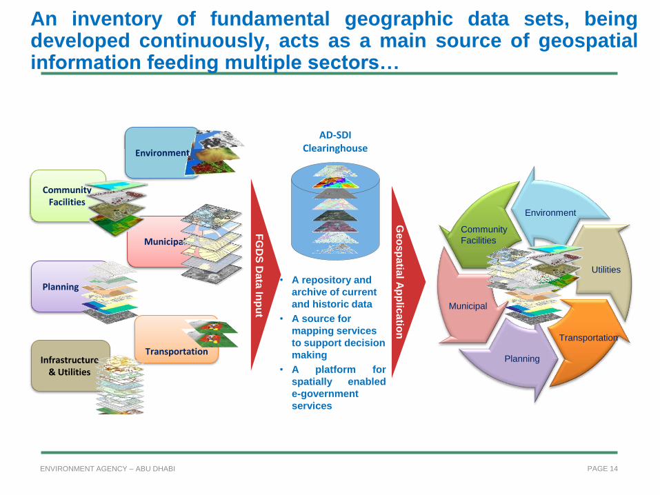
PAGE 14 ENVIRONMENT AGENCY – ABU DHABI
Municipal
Transportation
Community Facilities
Planning
Infrastructure & Utilities
Geo
sp
atia
l Ap
plic
atio
n
جيومكانيةت ال
طبيقا الت
FG
DS
Data
Inp
ut
AD-SDI Clearinghouse
• A repository and
archive of current
and historic data
• A source for
mapping services
to support decision
making
• A platform for
spatially enabled
e-government
services
Environment
Community
Facilities
Municipal
Planning
Transportation
Utilities
An inventory of fundamental geographic data sets, being developed continuously, acts as a main source of geospatial information feeding multiple sectors…

PAGE 15 ENVIRONMENT AGENCY – ABU DHABI
AD-SDI Geospatial Portal

PAGE 16 ENVIRONMENT AGENCY – ABU DHABI
8 Entities
100 Layers
36 governmental and semi-governmental Entities, with a limited number of academic and private Entities
250 Layers
51 Governmental & semi-governmental Entities, with increased participation of academic and private sectors, as well as partnerships with international organizations
400 Layers
2007
2008
2009
2010 2011
Evolution of the AD-SDI Community

PAGE 17 ENVIRONMENT AGENCY – ABU DHABI
• Instigate Geospatial thinking among the leadership
• Facilitates geospatial data sharing
– Acts as a data broker
License Agreements
– Fundamental Geospatial Data Sets (FGDS)
• SDI Standards
– Technology, Data & Services
• Software licensing policy (Abu Dhabi)
• Spatially enabling eServices
• Unified spatial reference system
• Provision of geospatial data services
– Enabling entities to create portals
AD-SDI Benefits

PAGE 18 ENVIRONMENT AGENCY – ABU DHABI
AD-SDI Benefits • GeoMaturity Assessment
– Create a geomature society
• Assists agencies (in need) with GIS
implementation
• Data acquisition and project/program
alignment
• Communications
– Coordinators
– Regular meetings (Stakeholders)
– Technical Committee, Working Groups,
Special Interest Groups (SIGs)
– Focus on community
– GIS User Conference/GIS Day
– Publication (newsletter “Coordinates”)

PAGE 19 ENVIRONMENT AGENCY – ABU DHABI
What should SDI do? Focus on Solutions
• Primarily SDI is all about making data or services accessible
and available
• Contribution to decision making is rarely assessed
• Generic data quality – one size fits all?
• True value realized only when solutions found for global &
local challenges
• Global environmental challenges such as Climate Change,
Water scarcity, land degradation, biodiversity loss, etc.
• Local challenges manifestations of Global Challenges
• Need to come up with solutions in a proactive manner
• “leverage the power of our collective intelligence”
• “Empowering a billion+ geospatially”

PAGE 20 ENVIRONMENT AGENCY – ABU DHABI
What should SDI do? Real Time Data
• We need real time understanding to make better informed decisions
• Real time data “transformed into information and knowledge leading
to understanding”
• “Rear view mirror driving” or “Bowling in the dark”
• Take real time data and feed it back with minimal turn around time.
• GEO/GEOSS, UNEP Live, Eye on Earth Network, etc.
• Prerequisites
• Ability to collect, manage and process real time data
• Have the right capacity – “good % of decision makers are still
not aware that the Geospatial community exist”
• Most leading GIS software have limited capability to process
large real time datasets & make sense out of it

PAGE 21 ENVIRONMENT AGENCY – ABU DHABI
Conclusion • SDIs have played a major role in making data available
• Many interesting initiatives already in place
• NSDIs, UN SDI, GSDI, etc.
• Build on the solid foundation created
• Focus needs to shift to utilization for making informed
decisions – “creating a better world”
• Real time monitoring and ability to quickly turnaround the
findings in making decisions
• Public Private partnership is essential for addressing the
global challenges.
• Government needs to provide authoritative data
• Let us “leverage our collective intelligence” and “empower a
billion+ spatially”

www.ead.ae
www.geoportal.ae
sdi.abudhabi.ae
geoportal.abudhabi.ae
Our site links :
Thank you all for listening !!!