Embed Size (px)
Citation preview
Real2sim: Automatic Generation of Open Street MapTowns For Autonomous Driving Benchmarks
Avishek MondalUniversity of Oxford, UK
Panagiotis TigasUniversity of Oxford, UK
Yarin GalUniversity of Oxford, UK
Abstract
Research in machine learning for autonomous driving (AD) is a constantly evolvingfield as researchers strive to build a Level 5 autonomous driving system. However,current benchmarks for such learning algorithms do not satisfactorily allow re-searchers to evaluate and compare performance across safety-critical metrics suchas generalizability, out-of-distribution performance, etc. Reasons for this includethe expensive nature of data collection from the real-world for autonomous drivingand the limitations of software tools currently available for autonomous drivingsimulators.We develop a pipeline that allows for automatic generation of new town mapsfor simulator environments from OpenStreetMap [Haklay and Weber, 2008].We demonstrate that our pipeline is capable of generating towns that, when per-ceived via LiDAR , share similar footprint to real-world gathered datasets likeNuScenes [Caesar et al., 2020]. Additionally, we learn a realistic noise aug-mentation via Conditional Adversarial Networks [Isola et al., 2017] to furtherimprove the similarity with real-world LiDAR . Our pipeline allows researchers forthe first time to benchmark at scale various AD agents, both in-distribution, andout-of-distribution.
1 Introduction
The challenge of autonomous driving has received a lot of attention in these past two decades from anumber of organizations, ranging from governmental entities such as Defense Advanced ResearchProjects Agency (DARPA) which ran the DARPA Grand Challenge in the mid/late 2000s [DARPA],to commercial actors like Weymo, Tesla or Toyota. Despite this attention over a long period of time,fully autonomous (Level 5) driving in urban environments remains an elusive problem to solve.
The main paradigm of developing autonomous driving agents is via simulated driving environments,such as CARLA [Dosovitskiy et al., 2017]. Simulators allow for quick turnaround of training andtesting different Autonomous Driving (AD) agents, with the aim of deploying such agents in realworld. Overcoming the so-called reality gap [Jakobi et al., 1995] requires significant engineeringeffort and measuring the safety and performance of the agents in real-world can be potentiallyrisky. Existing benchmarking tools focus on a limited set of maps or real world data gathered in thewild [Caesar et al., 2020, Sun et al., 2020], which don’t allow testing behaviors in an online fashion.
With this project we propose to overcome these limitations by bringing real world maps into asimulation environment (Real2Sim) to allow researchers to quickly test out-of-distribution andin-distribution scenarios.
Correspondence: [email protected]
Machine Learning for Autonomous Driving Workshop at the 34th Conference on Neural Information ProcessingSystems (NeurIPS 2020), Vancouver, Canada.
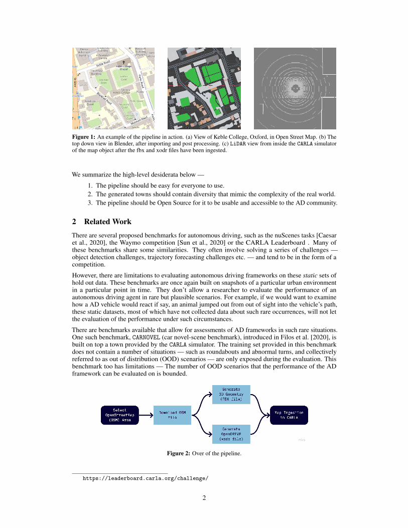
Figure 1: An example of the pipeline in action. (a) View of Keble College, Oxford, in Open Street Map. (b) Thetop down view in Blender, after importing and post processing. (c) LiDAR view from inside the CARLA simulatorof the map object after the fbx and xodr files have been ingested.
We summarize the high-level desiderata below —
1. The pipeline should be easy for everyone to use.2. The generated towns should contain diversity that mimic the complexity of the real world.3. The pipeline should be Open Source for it to be usable and accessible to the AD community.
2 Related Work
There are several proposed benchmarks for autonomous driving, such as the nuScenes tasks [Caesaret al., 2020], the Waymo competition [Sun et al., 2020] or the CARLA Leaderboard . Many ofthese benchmarks share some similarities. They often involve solving a series of challenges —object detection challenges, trajectory forecasting challenges etc. — and tend to be in the form of acompetition.
However, there are limitations to evaluating autonomous driving frameworks on these static sets ofhold out data. These benchmarks are once again built on snapshots of a particular urban environmentin a particular point in time. They don’t allow a researcher to evaluate the performance of anautonomous driving agent in rare but plausible scenarios. For example, if we would want to examinehow a AD vehicle would react if say, an animal jumped out from out of sight into the vehicle’s path,these static datasets, most of which have not collected data about such rare occurrences, will not letthe evaluation of the performance under such circumstances.
There are benchmarks available that allow for assessments of AD frameworks in such rare situations.One such benchmark, CARNOVEL (car novel-scene benchmark), introduced in Filos et al. [2020], isbuilt on top a town provided by the CARLA simulator. The training set provided in this benchmarkdoes not contain a number of situations — such as roundabouts and abnormal turns, and collectivelyreferred to as out of distribution (OOD) scenarios — are only exposed during the evaluation. Thisbenchmark too has limitations — The number of OOD scenarios that the performance of the ADframework can be evaluated on is bounded.
Figure 2: Over of the pipeline.
https://leaderboard.carla.org/challenge/
2
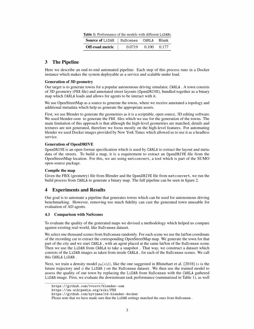
Table 1: Performance of the models with different LiDARs
Source of LiDAR NuScenes CARLA Blank
Off-road metric 0.0719 0.100 0.177
3 The PipelineHere we describe an end-to-end automated pipeline. Each step of this process runs in a Dockerinstance which makes the system deployable as a service and scalable under load.
Generation of 3D geometryOur target is to generate towns for a popular autonomous driving simulator, CARLA . A town consistsof 3D geometry (FBX file) and annotated street layouts (OpenDRIVE), bundled together as a binarymap which CARLA loads and allows for agents to be interact with it.
We use OpenStreetMap as a source to generate the towns, where we receive annotated a topology andadditional metadata which help us generate the appropriate assets.
First, we use Blender to generate the geometries as it is a scriptable, open source, 3D editing software.We used blender-osm to generate the FBX files which we use for the generation of the towns. Themain limitation of this approach is that although the high-level geometries are matched, details andtextures are not generated, therefore we focus mostly on the high-level features. For automatingblender we used Docker images provided by New York Times which allowed us to use it as a headlessservice.
Generation of OpenDRIVEOpenDRIVE is an open format specification which is used by CARLA to extract the layout and meta-data of the streets. To build a map, it is a requirement to extract an OpenDRIVE file from theOpenStreetMap location. For this, we are using netconvert, a tool which is part of the SUMOopen-source package.
Compile the mapGiven the FBX (geometry) file from Blender and the OpenDRIVE file from netconvert, we run thebuild process from CARLA to generate a binary map. The full pipeline can be seen in figure 2.
4 Experiments and ResultsOur goal is to automate a pipeline that generates towns which can be used for autonomous drivingbenchmarking. However, removing too much fidelity can cast the generated town unusable forevaluation of AD agents.
4.1 Comparison with NuScenes
To evaluate the quality of the generated maps we devised a methodology which helped us compareagainst existing real-world, like NuScenes dataset.
We select one thousand scenes from NuScenes randomly. For each scene we use the lat/lon coordinateof the recording car to extract the corresponding OpenStreetMap map. We generate the town for thatpart of the city and we start CARLA , with an agent placed at the same lat/lon of the NuScenes scene.Then we use the LiDAR from CARLA to take a snapshot . That way, we construct a dataset whichconsists of the LiDAR images as taken from inside CARLA , for each of the NuScenes scenes. We callthis CARLA LiDAR .
Next, we train a density model pθ(s|φ), like the one suggested in Rhinehart et al. [2018] (s is thefuture trajectory and φ the LiDAR ) on the NuScenes dataset. We then use the trained model toassess the quality of our town by replacing the LiDAR from NuScenes with the CARLA gatheredLiDAR image. First, we evaluate the downstream task performance (summarized in Table 1), as well
https://github.com/vvoovv/blender-osmhttps://en.wikipedia.org/wiki/FBXhttps://github.com/nytimes/rd-blender-dockerPlease note that we have made sure that the LiDAR settings matched the ones from NuScenes .
3
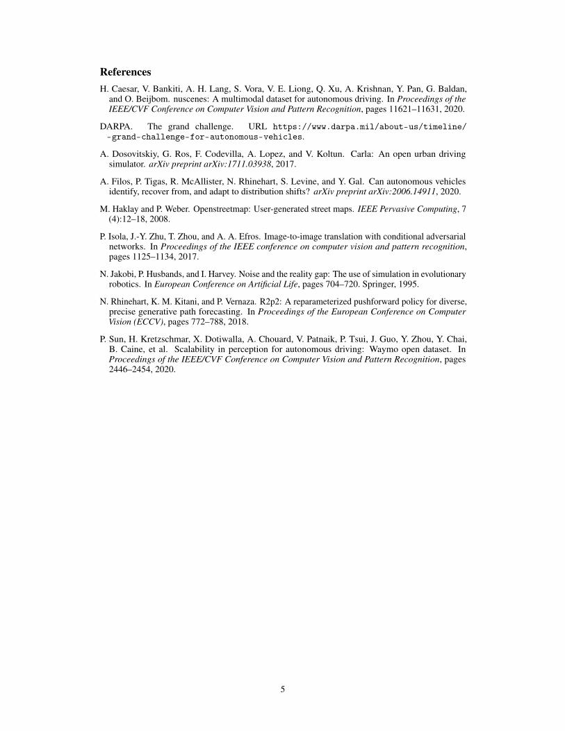
Figure 3: (a) LiDAR from CARLA (b) corresponding LiDAR from NuScenes (c) Results of applying P2P onLiDAR images from the CARLA images
as the difference of the distributions between pθ(s|φ, for different φ settings, measured with Kullback-Leibler (KL) divergence. Specifically we compare the following LiDAR settings: NuScenes (NS),CARLA (CARLA), corrupted NuScenes LiDAR with Bernoulli noise of probability α (NS-α) andfinally blank LiDAR (blank). We summarize the comparisons KLNS_α-NS, KLNS_CARLA, KLNS_blank onTable 2.
Experiment KLNS_α-NS, α = 0.2 KLNS_CARLA KLNS_blank
Mean 0.38334 0.38994 0.41349
Table 2: Table showing the average of KL divergences between using LiDAR images from the NuScenes dataset,and using LiDAR images from the CARLA simulator and lidar images after applying various values of α zeroingon the nuScenes dataset.
We found the distribution induced when LiDAR is fed from NuScenes , has the same KL divergencewhen we corrupt NuScenes with Bernoulli noise of p = 0.2 and when we replace NuScenes withCARLA dataset.
As summarized in table 1, we can see that the downstream task, although is affected when swappingNuScenes LiDAR with the one from CARLA , it’s less that the performance evaluated with emptyLiDAR (blank LiDAR case), suggesting the our generated towns maintain the fidelity required to solvethe task.
4.2 Realistic Noise Augmentation via Conditional Adversarial Networks
Although the LiDAR in CARLA captures the high level geometry (obstacles) correctly, in the real worldthere is noise that is not modeled in the LiDAR sensor of CARLA , making the received LiDAR imageslook unrealistic. We cast the problem of learning a noise model into an Image to Image translation.We used Pix2Pix [Isola et al., 2017], a GAN based model, to learn the conditional noise modelwhich make the LiDAR look closer to NuScenes . As we see in Figure 3, the image after the appliedtransformation look closer to the original NuScenes LiDAR . Although this is a promising direction,extra care need to be taken as the learned noise can introduce artifacts that can increase the uncertaintyof the model.
5 Discussion And Future WorkWith this work we demonstrated a pipeline for automatic generation of towns for autonomous drivingfrom real maps. The generated maps share similar LiDAR footprint with real-world gathered dataand therefore can allow for scaled-up benchmarks or data gathering of in-distribution and out-of-distribution scenarios. While this is a promising first step of brining real-world maps in simulatedenvironments, we are currently working in bring more detailed geometry and texture generation toallow also camera based perception systems as well.
An open challenge remains to generate diverse towns with various difficulties. We aim to extendthis work equipping it with an active process which will use the epistemic uncertainty of the trainedmodels to select map locations that will improve the policy.
Finally, we aim to make the tools and source code available online for the research community to useand build upon.
4
ReferencesH. Caesar, V. Bankiti, A. H. Lang, S. Vora, V. E. Liong, Q. Xu, A. Krishnan, Y. Pan, G. Baldan,
and O. Beijbom. nuscenes: A multimodal dataset for autonomous driving. In Proceedings of theIEEE/CVF Conference on Computer Vision and Pattern Recognition, pages 11621–11631, 2020.
DARPA. The grand challenge. URL https://www.darpa.mil/about-us/timeline/-grand-challenge-for-autonomous-vehicles.
A. Dosovitskiy, G. Ros, F. Codevilla, A. Lopez, and V. Koltun. Carla: An open urban drivingsimulator. arXiv preprint arXiv:1711.03938, 2017.
A. Filos, P. Tigas, R. McAllister, N. Rhinehart, S. Levine, and Y. Gal. Can autonomous vehiclesidentify, recover from, and adapt to distribution shifts? arXiv preprint arXiv:2006.14911, 2020.
M. Haklay and P. Weber. Openstreetmap: User-generated street maps. IEEE Pervasive Computing, 7(4):12–18, 2008.
P. Isola, J.-Y. Zhu, T. Zhou, and A. A. Efros. Image-to-image translation with conditional adversarialnetworks. In Proceedings of the IEEE conference on computer vision and pattern recognition,pages 1125–1134, 2017.
N. Jakobi, P. Husbands, and I. Harvey. Noise and the reality gap: The use of simulation in evolutionaryrobotics. In European Conference on Artificial Life, pages 704–720. Springer, 1995.
N. Rhinehart, K. M. Kitani, and P. Vernaza. R2p2: A reparameterized pushforward policy for diverse,precise generative path forecasting. In Proceedings of the European Conference on ComputerVision (ECCV), pages 772–788, 2018.
P. Sun, H. Kretzschmar, X. Dotiwalla, A. Chouard, V. Patnaik, P. Tsui, J. Guo, Y. Zhou, Y. Chai,B. Caine, et al. Scalability in perception for autonomous driving: Waymo open dataset. InProceedings of the IEEE/CVF Conference on Computer Vision and Pattern Recognition, pages2446–2454, 2020.
5